1. Introduction
Surface lignite mines exploited using a continuous mining method are typically large-scale excavation sites of high significance for primary energy production. The lignite extracted from these mines fuels high capacity thermal power plants. Although the operational life of a lignite mine usually spans many decades, after an intensive exploitation period, the content of lignite basins is depleted. Then, the lignite mines enter the closure phase that necessitates restoration of the post-mining sites, with beneficial effects to environment and society.
Continuous surface mining projects are very complicated because of the uncertainties associated with their dynamic situation. In this type of projects, the risks may relate to geological, technical, environmental, social, economic and other factors. In this framework, strategic mine planning, aimed at the rational exploitation of the coal/lignite deposits, is crucial for the sustainability of such projects. This planning should incorporate the restoration of mining sites, considering the optimal mine development and the related risks as well as the time and cost data of mining activities. It requires, therefore, an integrated approach and optimization based on technical, economic, environmental, safety or social parameters.
Post-mining land restoration is related to integrated and long term practices of high social, economic and environmental impact. Literature reports various restoration methods. Some are more technical, dealing with engineering solutions for mitigating environmental impacts of the post-mining sites [
1,
2]. Others focus on restorations mainly achieved by natural processes, known as ‘spontaneous succession’ [
3] or suggest hybrid or ‘near natural’ solutions [
3,
4]. Most of the methods cited consider reclamation as a fundamental activity related to extended earthworks for the removal of the excavated waste material (mainly consisting of interburden, overburden and topsoil material) and subsequent use of as much volume of this material as possible for the filling of excavation pits, voids and other open trenches shaped during the mine life cycle [
2,
5,
6]. Based on the rules of aesthetics as well as of landscape architecture, the reclaimed areas should be perfectly integrated towards landscape reformulation and upgrading [
7].
The planning of mining restoration is a multidisciplinary task requiring the synergies of managers, engineers, environmentalists, risk analysts and experts from various fields of science and technology, as well as local stakeholders (i.e., independent parties/bodies with interests or concerns in the approval and licensing of restoration projects). The main planning objective is to select the techno-economically feasible and low risk sustainable restoration methods that are the most advantageous for each site-specific case in terms of economic growth, prosperity of local society and ecosystem balance. In this context, the spatial analysis of selected indicators and cartographic overlay using ArcGIS applications can provide a useful tool, either for evaluating the corresponding sustainable exploitation of a mineral deposit [
8] or for selecting the optimum land uses that should be developed in the reclaimed lands after the mine closure [
9,
10,
11].
The surface mine restoration projects are associated with numerous risks and uncertainties related to natural and technological parameters [
12,
13]. As a result, the decision making for the selection of the most advantageous alternative is a difficult and complicated process. Therefore, the early identification of restoration risks and their impacts enables decision makers to have a substantial basis of understanding the advantages and disadvantages of each alternative. In turn, they will be able to select the optimal one which combines the lower risks with the higher expected benefits for the environment, society and economy. This is still a challenging research topic in the field of optimization, restoration and sustainability of surface coal mines.
The development of MCDM methods and techniques is a growing trend worldwide. Recently, a considerable literature has grown up around this field, covering a wide spectrum of academic research and practical applications in the industry, such as project and risk management, business and finance, manufacturing, etc. [
14,
15,
16,
17] From this spectrum, the mining industry should not be an exception [
18]. Taking into account that the mining projects are long term and large scale frameworks with high inherent complexity, the needs of solving problems regarding the production optimization, land management and reclamation planning are critical and require substantial, cost effective, environmentally friendly and regulatory compliance decisions.
In the mining industry, various MCDM techniques and associated research have been developed in the recent decades. According to Mahase et al. [
18], those techniques are applied to support, in principle, decision making needs for mine planning and related problems. Sousa Jr. et al. [
19] used the PROMETHEE and ELECTREE methods in a process for the selection of highway trucks for mining operations. Musingwini [
20] and Musingwini and Minnitt [
21] ranked the efficiency of certain mining methods using the analytical hierarchy process (AHP) technique. Relevant to the mining methods selection are also the works of Bitarafan and Ataei [
22] and De Almedida et al. [
23] Yavouz [
24] proposed a method for equipment selection using a combination of Yager’s method and AHP. For the selection of the most appropriate underground mining method, Karadogan et al. [
25] presented the application of fuzzy set theory in a case for the selection of an underground mining method. Kazakidis et al. [
26] suggested the application of the AHP in a series of different case studies/scenarios to investigate the investment analysis of a new mining technology, the design aspects for the ground support, the design of tunneling systems, the shaft location selection and the mine planning risk assessment. Khakestar et al. [
27] performed a multi-criteria evaluation based on a hybrid combination of the fuzzy AHP and the technique for order of preference by similarity to ideal solution (TOPSIS) techniques for the selection of the optimum method regarding the slope stability analysis in open pit lignite mines. Bazzazi et al. [
28] assessed a combination of the AHP and TOPSIS techniques to select optimal loading-haulage equipment for the Sungun open pit mine in Iran. Bascetin [
29] recommended a decision support system using the AHP technique for the optimal reclamation of an open-pit mine. Finally, Uberman and Ostrega [
30] applied the AHP in a project selection for the revitalization of post-mining areas.
The results of the above investigation indicate several interesting findings:
- (a)
The MCDM methods are mainly focused on needs for improvement of the mining operations and equipment supply, while the post-mining restoration activities seem to be of a lower priority.
- (b)
A preference for the development of decision making methods as combinations (or “hybrids”) of two, or more, MCDM techniques is noted.
- (c)
The AHP tends to be the fundamental constituent element in most of the hybrid techniques and, especially, for the decision making step, where the weights of the criteria are determined.
- (d)
References regarding the assessment of risk-based decision making for the restoration of continuous surface mines are limited.
In this context, the aim of this paper is to propose a new approach to the research field of planning the land reclamation of surface mines by (a) demonstrating the decision-making problems and risks related to the selection of an appropriate post-mining restoration technology/method and (b) suggesting a low risk methodology based on multi-criteria decision making (MCDM) techniques, aiming to better understand and control the risks in surface mining restoration projects. Within this framework, the paper introduces a hybrid MCDM methodology [
31,
32,
33,
34,
35], which is a combination of AHP (analytical hierarchy process) [
36,
37,
38] and TOPSIS (technique for order of preference by similarity to ideal solution) [
34,
35], and fills a gap in the literature regarding the quantitative risk assessment in the field of mine land reclamation. A case study approach was used for the implementation of the methodology considering the selection of the lower risk restoration/reclamation method in a continuous surface lignite mining project.
The paper is organized as follows: the second section provides background information on restoration planning and the related risks and impacts. The third section presents practical decision-making problems and questions. The fourth section describes the suggested MCDM methodology. The fifth section demonstrates the implementation of the methodology in a case study. The final section provides conclusions, and directions for future research.
2. Background
In many countries, such as Germany [
1], the Czech Republic [
2], India [
5], UK [
39], the US [
40] and Greece [
41], the restoration of mining sites and industrial areas is a regulatory requirement. In this frame, the restoration of continuous surface lignite mines requires a multidisciplinary approach and properly planned activities of returning the mined-out lands to a form of acceptable environmental condition and productivity [
5], along with beneficial returns to society and the economy. Nevertheless, the analysis of mining industry practices reveals that there are several restoration approaches, since the restoration does not follow a standard conceptual model, because of the significant differences in mining conditions. The exploitation models depend on the specific physical and operational characteristics of each mine. However, the post exploitation situation depends, mainly, on the geo-environmental features of the mined-out sites, as well as on the environmental legislation and regulatory constraints. Empirical evidence and literature deals with various restoration approaches, however, three representative technologies can be, in principle, figured out: (a) technical restoration [
2,
42], (b) natural restoration driven by interactions between various bio-ecological and non-biotic factors [
1] and (c) combined restoration consisting of partial human intervention developed in parallel to the natural restoration processes [
2,
4,
6].
The basis for a techno-economically effective and environmentally friendly restoration plan is the successful reclamation of mined-out lands [
1,
2,
5,
6]. Reclamation is a large scale reinstatement activity aimed at returning the mined-out site to its original form, productivity and land use. Thus, reclamation enables landscape remodeling and, being conducted with other human activities and/or natural restoration processes, it contributes to the recovery of areas affected by the intensive operations of mine exploitation. The reclamation works during mining operations are mainly related to the extended backfilling of open pits, benches, open trenches and voids shaped by the mining activities.
From the project management viewpoint, restoration may be seen as a sub-project in a wider environmental management program, which maintains its own budget, execution schedule, organization, human resources, equipment and materials. Once a restoration project is under planning, managers, engineers and restoration experts are working in synergy to outline, in an appropriate level of integration, a multidisciplinary project definition report. For this purpose, they decompose and analyze thoroughly the geo-environmental conditions of the mining landform characteristics, as well as the techno-economic profile of the restoration project. In this analysis, critical parameters for the identification of restoration methods are assessed, i.e., quality of disposed soils, lakes and rivers, air pollution, topsoil fertility, infrastructure (roads, railways and welfare facilities), abandoned mining machinery, toxicity of discarded wastes, reforestation, recreation, geo-hazards, land use parameters, etc. The data required for the restoration analysis are collected through field investigations across the mined-out sites, water and soil laboratory analyses, satellite imagery and cartographic/GIS analysis products [
2,
43], as well as through review of statistical records, scientific literature and technical documents of the mine facility. The synthesis of a comprehensive restoration plan, recommending several technically adequate restoration methods and suggesting the most advantageous one for implementation, is a common practice in the evaluation phase of such projects. The plan is also delivered to the involved parties and stakeholders (environmental agencies, investors, municipalities, NGOs, etc.) for consideration and decision making.
On the other hand, the long term mine restoration projects, with time frames varying from few years to decades, are related to various risks. These risks have to be identified as early as possible, and an assessment of the impacts should be conducted. This work is critical for the determination of the overall risk associated with each alternative restoration method, in order to evaluate and finally select the lower risk alternative as appropriate and technically adequate for implementation.
A thorough investigation of the fundamental restoration risks has been reported in the work of Roumpos et al. [
12], however, a further analysis on this topic exceeds the scope of this paper. The main risks are grouped in five categories, while each category is further divided into sub-categories as depicted in
Table 1,
Table 2,
Table 3,
Table 4 and
Table 5: technical risks, geological and geotechnical risks, permitting risks, socio-economic risks and environmental risks.
3. Decision Making: Problems and Questions
The restoration of continuous surface lignite mines are projects of high technical, environmental and socioeconomic complexity, since the post-mining sites cover hundreds of square kilometers. In addition, restoration activities usually last for many years. The success of the restoration projects depends on the quality of restoration planning and decisions taken in the pre-investment phase. In fact, the improper evaluation of restoration plans might lead to unsuccessful decisions to accept inappropriate plans as feasible or, conversely, to reject restoration plans which in a deeper level of analysis are feasible and sustainable. Therefore, the decision making for the evaluation and selection of the most advantageous restoration technology for implementation is very critical, as it is directly related to whether a restoration project can be successfully implemented, delayed or may even lead to failure. Therefore, the quality of decisions is crucial and constitutes a vital element that indicates whether a restoration project can be implemented or not, particularly in the pre-investment phase, where the project feasibility and planning is subject to investigation.
The mining practice shows that the significant differences observed between restoration projects introduce various technical and managerial problems. Consequently, several considerations and screenings for the primary geo-environmental factors and reclamation technologies or methods advised by the restoration experts may be conflicting. For instance, a simple and low cost reclamation technology in sites polluted by toxic discarded materials might generate new environmental impacts of high severity. Moreover, the inappropriate restoration activity may relate to land use incompatibilities in a way that the restored land could become inappropriate for reforestation, recreation or re-cultivation. This fact might be subject to rejection by environmentalists, permitting agencies, socioeconomic analysts or stakeholders.
There are various decision making practices with respect to project management. Each practice depends on the nature of the project, the collective performance of experts and managers, environmental sustainability policies and regulations, budgetary and resource constraints and other geo-environmental factors. Some practices are very formal and move within the standards of administrative and legal protocols of public agencies and organizations involved with the regulatory compliance of mining restoration plans or wider programs. Other more empirical and subjective practices are based on mining experts’ judgement and rely on comparisons with previous projects of similar scale, type and techno-economic profile. Some practices examine combinations of empirical evidence of the geo-environmental and ecological conditions of the under restoration areas, while others focus on the perspectives of restoration returns by considering the restoration project as a pure business case. In this view, project managers and restoration experts, in order to achieve an integrated and substantial approach to select the most adequate alternative technology/method of restoration, are called to solve various technical problems and to answer critical questions, such as:
Which restoration technology/method is environmentally friendly, sustainable and cost-effective against others?
Which technology/method should be appropriate for obtaining the approval of the authorities?
Which technology/method requires the minimum modifications of existing infrastructures?
Which technology/method ensures efficient soil improvement, landscape remodeling and visual amenity?
Are the environmental, ecological and biodiversity requirements completely met?
Do the alternative technologies/methods satisfy needs for new businesses opportunities, reduction of unemployment and enhancing the livelihood of local communities?
Are the alternatives appropriate for the recovery of biodiversity, reforestation, replantation and recultivation?
Are the water management proposals suitable for the development of recreational facilities?
Are the measures for protection against natural hazards properly investigated?
Are the methods of toxic wastes removal and water treatment ensuring people’s safety/health?
Are the required mechanical means and resources available for the execution of the restoration earthworks?
Are there any possibilities for restart, if necessary, of the mining activities in the future?
As the list of relevant questions is long, it becomes obvious that there are many open points which, by their nature, generate significant and multilateral risks. Since the main decision making objective is the selection of the restoration alternative with the lower risk, it is suggested that these risks should not be simply considered as a contingency element in the project investment analysis. Instead, it is suggested that the decision makers should perform a substantial analysis of the restoration risks, where the risks are grouped and classified into specific categories. In this analysis, the risks can be quantified in a form of numerical data and used as criteria for the evaluation of the restoration alternatives. The quantification of risks can be obtained through properly structured questionnaires, where evaluators/experts can express their own perception on the significance of each risk, based on their professional experience. To this regard, the alternative technologies/methods can be evaluated, in terms of an MCDM methodological approach, considering the relative risks. Thus, the ‘total risk score’ for each alternative can be determined in a numerical form and the alternative with the lower total risk score can be selected as the most appropriate.
4. Suggested Methodology
The suggested methodology focuses on the application of MCDM methods and techniques [
44], highlighting their utility as a tool for supporting decision making, regarding the evaluation of post mining restoration projects. The main objectives of the methodology are the following:
- (a)
To interpret the restoration risks in terms of evaluation criteria and to show how the relative weight of every individual criterion/sub-criterion can be expressed in numerical form.
- (b)
To show how any alternative restoration technology/method can be decomposed in a risk-based classification matrix in accordance with a pattern for the classification of risk impacts as low, medium or high severity.
- (c)
To present how the relative weights of the identified criteria/sub-criteria can be used in combination with the risk and sub risk factors to calculate the overall risk of each alternative and, thus, to rank the alternatives.
- (d)
To prove the applicability of the methodology in a case study regarding the restoration project of a continuous surface mining operation in Northern Greece that enters the closing phase.
The methodology combines two widely known MCDM techniques: the AHP, applied for the quantitative expression of risk-based criteria and sub-criteria, and TOPSIS, applied for the calculation of the overall risk of each alternative and the ranking of the alternatives according to their total risk scores. In the AHP technique, experts use their knowledge, insight and professional experience to analyze the decision-making problem, by defining hierarchy levels and to solve it. In this framework, they follow an evaluation process based on quantified criteria. The selection criteria and sub-criteria in the restoration project of the case study are the relative weights of the identified risk and sub-risk factors. The decision makers perform pairwise comparisons, taking into account the 1–9 rating scale advised by Saaty [
36,
37,
38,
45], to evaluate the criteria and to structure and normalize a reciprocal pairwise comparison matrix. The computational process is verified by a mathematical consistency check and the relative weights of risk factors and sub-factors are finally identified. TOPSIS is based on the assumption that the most advantageous alternative should have the shortest distance from the ideal solution and the highest distance from the negative ideal solution (this distance is also known as ‘Euclidean entity’). In this context, the distances of each alternative from the ideal and the negative alternative, respectively, enable the final ranking and classification of all alternatives [
32,
33,
35].
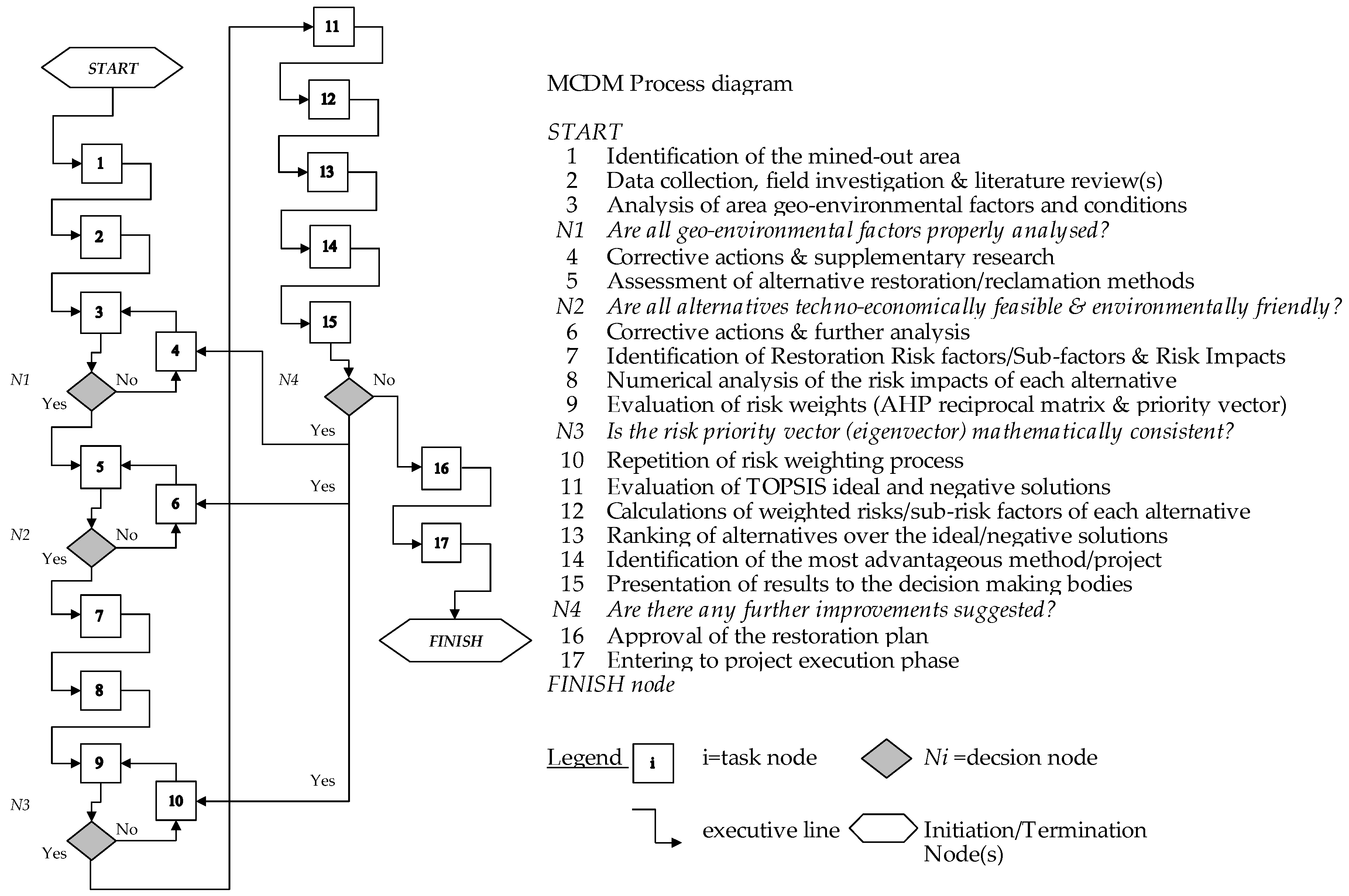
Figure 1 describes the suggested methodology as a process model, based on the combination of the AHP and TOPSIS techniques.
5. Implementation
5.1. Case Study: Restoration Project Overview
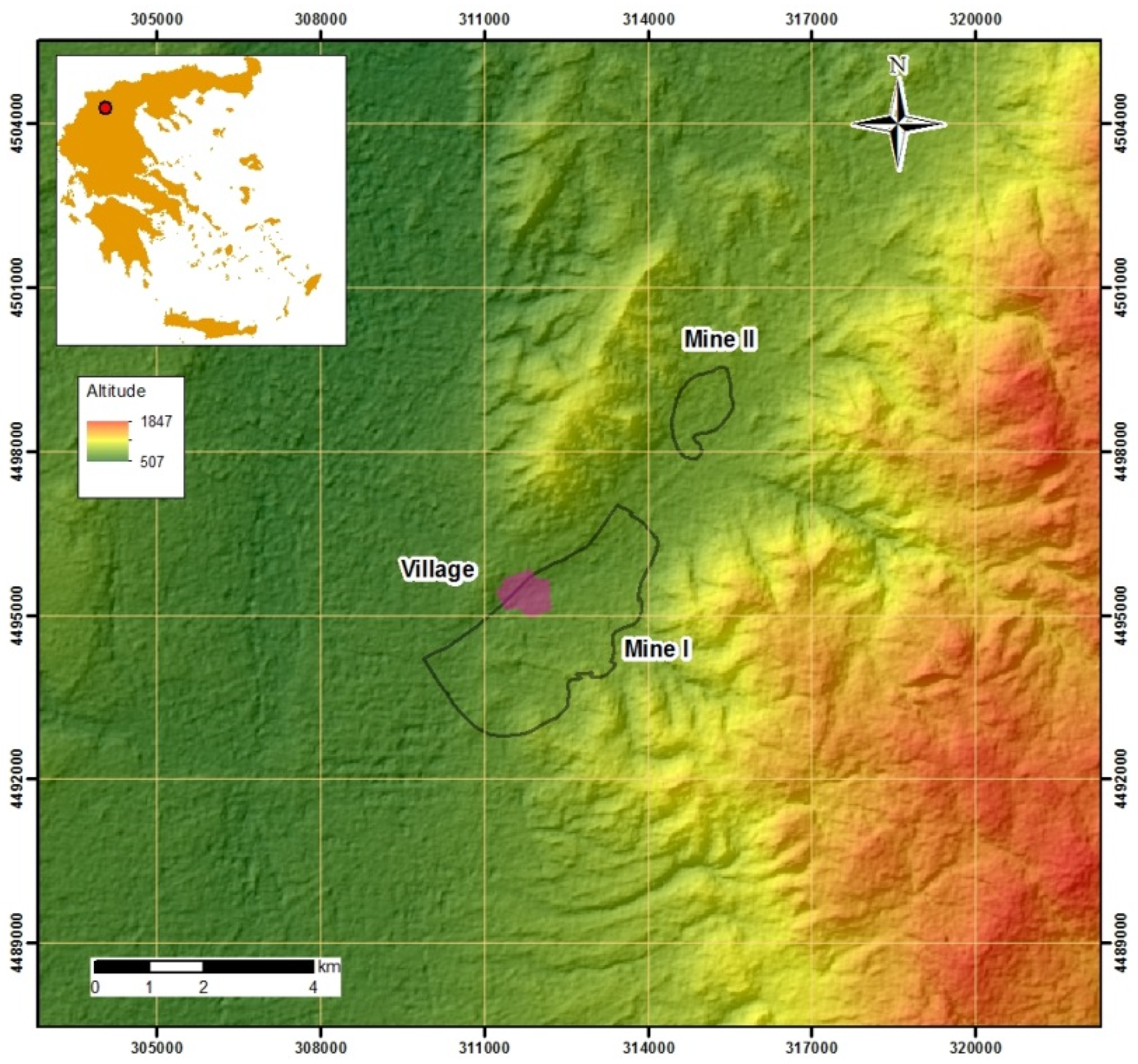
The case study refers to a restoration project of a continuous surface mine, including two lignite fields (Mine I and Mine II,
Figure 2) planned for the exploitation of a lignite deposit located in northern Greece. Between the two mining fields a ridge is found with no lignite occurrence. The mining site is hilly, with surface altitudes ranging between 700 m–900 m above sea level. At the western boundary of the mining area, there is a village with 100 inhabitants. The mine contributes in meeting the lignite demand of a power plant located 12 km west of the mining area.
The lignite basin has a channeled form and it is broadened from the NE to the SW direction, along with local increases of surface elevations. The area of mining activity covers approximately 10 km2. The deposit is of a multiple-layered form, and lignite seams are almost horizontally bedded. However, a series of normal faults results in a progressive and systematic deepening of the beds and in a corresponding increase the thickness of overburden material towards the SE rim of the basin. The main characteristic of the deposit is the occurrence of conglomerate hard material in the overburden formations.
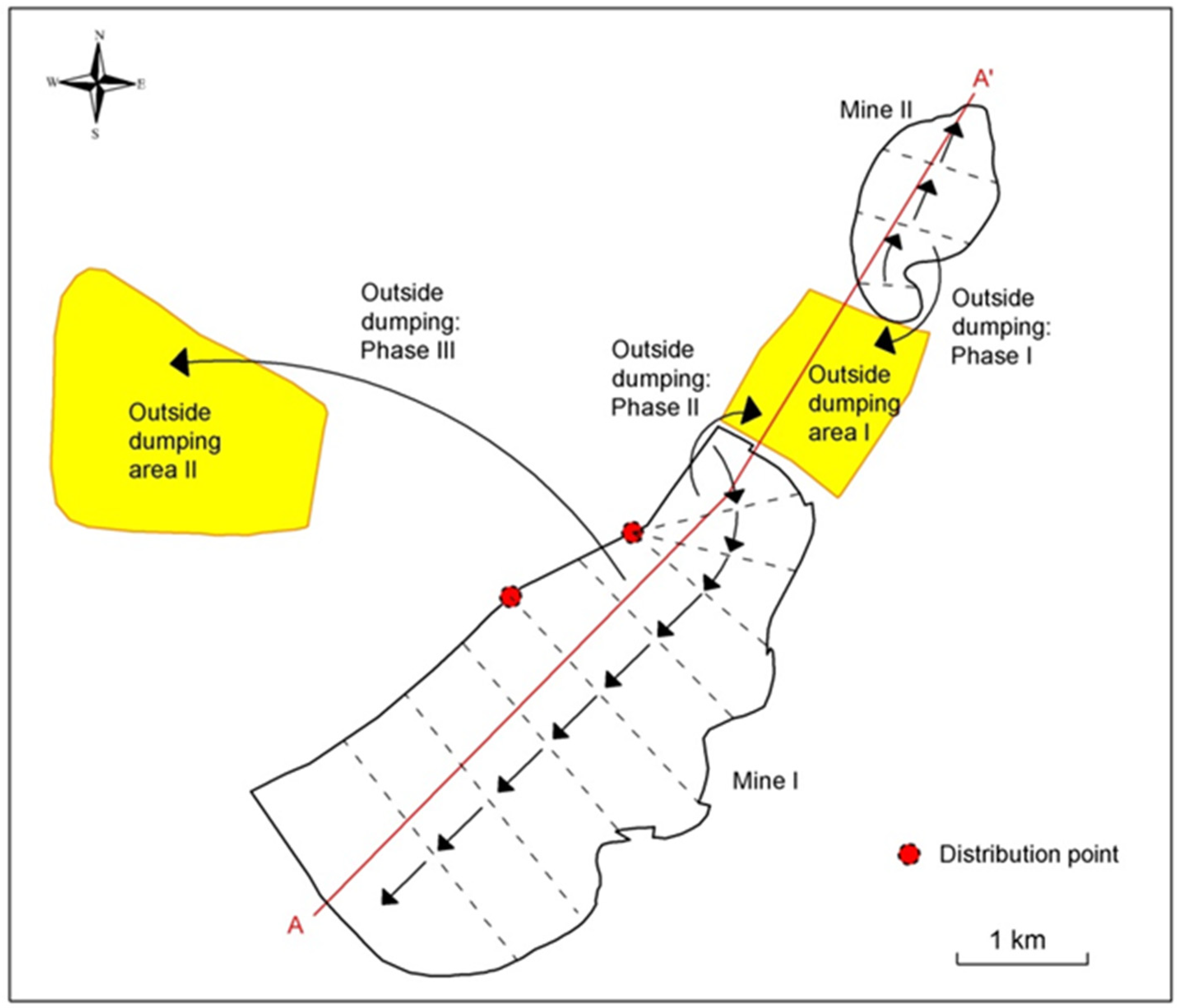
The strategic mine development, including the two outside dumping areas, is shown in
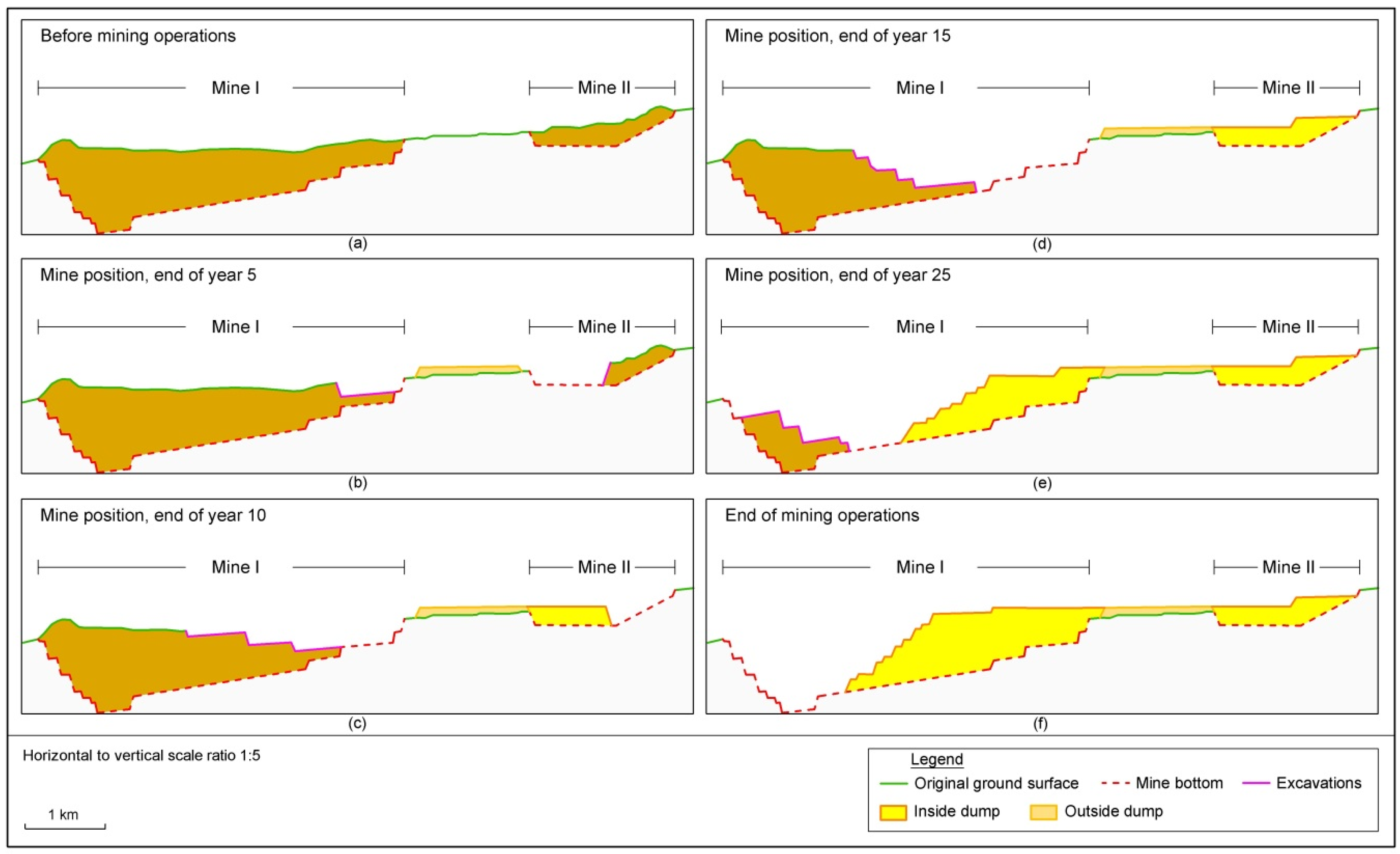
Figure 3. The main outside waste dumping area is located 1.5 km NW from the mine. The sequence of mining operations, considering time periods of 10 years, from the initial to the mine closure stage, is presented in
Figure 4.
The main mining equipment consists of bucket wheel excavators, conveyors and spreaders and the decision making regards the optimal restoration of the mine after 25 years of operation, while its remaining life is 10 years. At this stage, the waste material of the excavation activities is transported to the inside dumping area. Following the mine closure plan, a lake was planned to fill the existing area voids.
5.2. Description of Alternatives
The following three (3) restoration alternatives were examined (the comparative cost data were collected from [
46,
47,
48,
49]):
(A1) Technical Restoration: It refers to a project with high capital expenditures (3.500–5.000 €/ha) and an implementation period of 3–4 years. The project targets are: (a) large-scale reclamations for recovering the affected landscape, (b) treatment of contaminated, polluted or toxic soils and waters, (c) measures and infrastructures enabling development of recreation activities, (d) upgrading of biodiversity at post mining ecosystems. The measures and main infrastructures suggested are: slope stabilization; excavation/backfilling of removed earth material; land compaction/relevelling; redesign and reconstruction of existing roads; erection of buildings for accommodation of 300 visitors; erection of recreation and cultural facilities (sport camps and a museum for the mining history); reforestation/replantation to the 35–40% of the entire project area; upgrading of near lake settlement; installation of fire protection system; utilities for irrigation, sewing, water supply, power and communication; removal of polluted, contaminated and toxic wastes and charged waters; replacement of selected topsoil; measures ensuring land fertility; measures for recovery of sensitive habitats and biota; measures for increase of employment.
(A2) Restoration focused on Natural Processes: It refers to a project with low capital expenditures (less than 500 €/ha) and an implementation period of 10 years. The project targets are: (a) medium to low scale reclamations for recovering the affected landscape, (b) treatment of contaminated, polluted or toxic soils and waters, (c) protection of biodiversity at post mining ecosystems. The measures and main infrastructures suggested are: selective backfilling at the most adversely excavated lignite layers and seams; soil and stabilization at locations with the highest possibility of post mining erosion effects; removal of polluted, contaminated and toxic soil, mining wastes and water bodies; installation of fire protection system; irrigation and water management measures; measures for recovery of sensitive habitats and biota; replacement of selected topsoil at locations with recultivation capability and good fertility; implementation of a long-term environmental monitoring and physical restoration plan (also known as ‘spontaneous succession’ [
5]) plan.
(A3) Combined Solution: It refers to a project with moderate capital expenditures (800–1500 €/ha), with an implementation period of 5–7 years. The project targets are: (a) large-scale reclamations for recovering the affected landscape, (b) treatment of contaminated, polluted and toxic soils and waters, (c) measures and infrastructures enabling mainly the development of agroforestal activities, (d) upgrading of the biodiversity at post mining ecosystems. The measures and main infrastructures suggested are: excavation and backfilling of removed earth material; soil and slope stabilization; compaction and levelling; local modifications of existing traffic network; erection of low scale recreation and cultural facilities (sport camps and a museum of mining history); reforestation/replantation of the 25–35% of the project area; installation of fire protection system; removal of polluted, contaminated and toxic soil, mining wastes and water bodies; replacement of removed/selected topsoil at the 40–50% of the project area; measures for recovery of sensitive habitats and biota; implementation of a long-term environmental monitoring and physical restoration plan.
5.3. Risk-Based Analysis
The risk severity impacts are presented in
Table 6, reflecting the classification of risks and the units/parameters used to measure the risk severity. In turn, the risk severity is classified into three main categories: low, medium and high, along with the numerical values. Based on these values, the severity of any impact can be determined (the risk impact measuring units were identified by empirical evidence and by considering the specific geo-environmental conditions of the mine restoration plan that were described in the
Section 5.1). These values are based on the PMI [
50] practice, not to follow a linear order for the escalation of risk severity, but to apply the relation a(n) = 2
n (n∈N
0). Thus: 2
0 = 1: low impact, 2
1 = 2: medium impact and 2
2 = 4: high impact [
51] (
Table 7).
5.4. Risk Factors Definition
The definition of the relative weight of each criterion has been performed by applying the AHP technique according to the following steps [
32,
37,
38,
45]:
Step 1: Establishment of a pairwise comparison matrix for weighting the main risks; the experts compose a square matrix consisted of two triangular sub-matrices by making pairwise comparisons of each criterion with each one of the other criteria using the Saaty scale of comparison (
Table 8). Calculation mode: if a(i, j) is an element of this matrix (k: column and l: row) the lower diagonal element is produced using the formula a(k, l)*a(l, k) = 1 (
Table 9);
Step 2: Normalization of the pairwise comparison matrix and extracting the relative weight of each criterion, WRi | i = 1, 2,.., n, n ∈ N
; n is the number of criteria; WR(i) represents the priority, or eigenvalue, vector (
Table 10); mathematical conditions: 0 < WRi < 1 and
;
Step 3: Performing the consistency control to validate the consistency of priority vector; the control aims to check if the consistency ratio CR < 0.10; if so, the data of priority vector is appropriate for further utilization as inputs in TOPSIS calculations. Otherwise, the risk weighting process is repeated;
Step 4: Steps similar to the above 1–3 and consistency controls are carried out to produce the priority vectors WR(i, j) of each group of sub-criteria (sub-risks).
5.5. Ranking of Alternatives
The application of TOPSIS aims to define the score of each alternative and the final ranking of the alternatives and, hence, to demonstrate the lower risk, or ‘best’, alternative restoration method (
Table 7). The steps developed for TOPSIS technique application are the following:
Step 1: calculation of S =
1/2, where, i = number of criteria/sub-criteria, j = number of alternatives and Rv(i, j) the risk severity value of each alternative j over the criterion i (data extracted from
Table 2) and division of each Rv(i, j) element by S to get the R(i, j) vector;
Step 2: Multiplication of each R(i, j) element by WR(i) to get the vector V(i, j);
Step 3: Determination of the ideal solution A* by forming the vector V*(j) that contains the minimum value elements of vector V(i, j) (the lower risk element of each criterion);
Step 4: Determination of the negative ideal solution A’ by forming the vector V’(j) that contains the maximum value elements of vector V(i, j) (i.e., the higher risk element of each criterion);
Step 5: Calculation of the separation from the ideal solution (Euclidean distance) by forming the vector Si* = {[V(j)* − V(i, j)]2}1/2;
Step 6: Calculation of the separation from the negative ideal solution (Euclidean distance) by forming the vector Si’= {[V(j)’ − V(i, j)]2}1/2;
Step 7: Calculation of the relative closeness to the ideal solution Cj* = Sj’*(Sj* + Sj)−1; the elements of vector Cj* represent the score of each alternative; the optimum, or ‘best’ or most advantageous alternative, is the one with the highest total score: max [Cj*] = max [C1*, C2*, …, Cj*].
The final ranking is: C3* = 0.819 < C2* = 0.515 < C1* = 0.447 (
Table 11). The lower risk alternative with the higher performance in the scheme AHP/TOPSIS is A3, which refers to the combined restoration technology. The second best is A2 (restoration focused on natural processes) and the last in the sequence, the higher risk alternative, is A1 (technical restoration). This result clearly indicates that the evaluators (experts) consider the alternative A3 as optimal, taking into account that this has the lower total risk score and also that it is based on the balance between the technical activities and the natural processes at the mined-out area.
5.6. Discussion
The analysis confirms that the suggested methodology can provide a decision making framework for the landscape planning and restoration of surface mining projects. In this context, the proposed approach (a) ensures objectivity in the identification and determination of the relative weight of each risk factor/sub-factor and (b) demonstrates the selection of the optimum restoration technology in a clear and explicit way, enabling decision makers to understand the results of the multi-criteria evaluation process and to make a reasonable decision.
The lack of precise quantitative data in the mining projects makes the complete understanding of the restoration needs and perspectives quite difficult. To overcome this deficiency, the study suggests the knowledge elicitation of mining managers and production engineers and the transformation in an explicit form by combining AHP and TOPSIS techniques.
The combination of the two techniques allows better decision making, considering the advantages and the shortcomings of each technique. For example, since TOPSIS by its nature (based on the Euclidean distance) does not allow correlation of the criteria, the correlation can be achieved by means of the AHP pairwise comparison.
Regarding the strengths of the AHP/TOPSIS combination, the AHP is flexible in application and allows the consideration of subjective and objective factors in the decision making process. Furthermore, in AHP applications, the experts, through interpersonal contacts or properly prepared questionnaires, offer their judgment for the structuring and processing of reciprocal matrices, where the risk factors are identified and correlated. The higher experience of the experts in the management of mining restoration risks ensures the better identification and evaluation of the relative weights of risk factors and sub-factors. In this work, the option of interviewing three qualified experts with long term experience (>20 years) in surface mining systems was adopted. In this way, the relative weights of the identified risks meet a high level of technical justification and reliability that increases the objectivity of the technique, to the extent possible. In addition, the application of TOPSIS allows the “bounding” of the risk ranking between the “positive ideal” and the “negative ideal” solution, thus, the definition of the total risk is combined with mathematical clarity and simplicity.
On the other hand, with the combination of the AHP and TOPSIS techniques, the subjectivity cannot be eliminated, since the experts have their own perceptions and biases on the significance of each individual risk in relation to the restoration alternatives. This problem is more complicated in cases where the group of experts is not exclusively composed of mining specialists, but also includes representatives assigned by municipalities, public agencies, NGOs, etc., with different educational background, environmental perception or objectives. In such cases, many repetitions of the AHP may be required to fulfill the consistency criterion. Another weakness is the performance limitation and inefficiency, especially in cases where the number of alternatives and/or the number of risk factors and sub-factors is high.
In conclusion, for the successful implementation of the methodology, an appropriate organization and control of the whole decision making context is required. The objectives of the restoration project should be well defined, and the weaknesses and inefficiencies of the AHP/TOPSIS applications must be identified and considered.
6. Conclusions and Perspectives for Further Research
The MCDM philosophy could be adopted to support the risk management needs in projects of surface lignite mines restoration. The selection of a lower risk restoration technology/method is critical as it provides a substantial basis for the decision makers to realize that a restoration project is technically feasible and environmentally friendly, with benefits for the environment, society and economy, and can be completed meeting the cost and time constraints.
This work makes an important contribution to the field of geo-energy, by demonstrating how the principles of risk management can be adapted in complex projects of mining restoration on the basis of computational simplicity of the applied MCDM methods. In this context, the appropriate multi-criteria methodology can be an efficient decision making support tool in terms of objectivity, mathematical consistency and clarity of the quantitative results.
The suggested methodology enables the evaluation and selection of technically appropriate and low risk technologies/methods for the restoration/reclamation of closing surface mines through the combination of AHP and TOPSIS techniques, with an aim to solve practical risk-based decision making problems. However, the combined AHP and TOPSIS application has specific limitations, especially in cases where the number of criteria or the alternatives is high, or the group of experts presents educational, professional or cultural heterogeneities.
The AHP method, as a decision-making tool, is simple and easy to use and allows the low cost analysis and quantification of project risks, by aggregating the knowledge of mining and restoration experts and transforming it in an explicit form. The TOPSIS uses the relative weights of the risk-based criteria and sub-criteria, identified by the AHP, as inputs of the numerical calculations for the definition of the ideal and negatively ideal solutions and, therefore, for obtaining the ranking of mine restoration alternatives. Both techniques are used, on an individual basis or in combination with others, in the evaluation of mining projects.
Finally, some proposals for further research are pointed out. One relates to the investigation of restoration risks in a more analytical concept. For example, the crisp values 1, 2 and 4 corresponding to risk impacts classification as low, medium and high, could be further analyzed in five levels, by defining interim numerical values between low and medium and also between medium and high levels of severity. Thus, the classification of risk impacts can be analyzed in a more detailed basis. Moreover, the aforementioned crisp values can be interpreted in a form of fuzzy variables to express the uncertainty of each specific risk using simplified linguistic expressions. Therefore, the methodology could be further improved in more sophisticated approaches. Moreover, other MCDM techniques such as PROMETHEE (I or II), ELECTRE, SMART, VIKOR, DEMATEL, fuzzy versions of these techniques, Bayesian networks, neuro-fuzzy algorithms or other hybrid techniques could be used instead of TOPSIS for risks quantification and processing. Finally, a comparative analysis of the performance and efficiency of various MCDM methods in a decision making framework related to mine restorations can be performed.


