Evaluation of the Potential of Biomass to Energy in Portugal—Conclusions from the CONVERTE Project


 ,
,  , ,
, ,
Abstract
1. Introduction
2. Materials and Methods
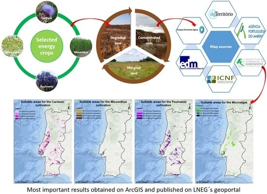
- To select the energy crops to implement in the mainland Portugal;
- To search which types of soils are of interest and present a low ILUC (indirect land-use change) risk;
- To search and download all colletected maps finded in shapefile or raster format from official websites of Portuguese Institutions like Agência Portuguesa do Ambiente (APA), Instituto Superior de Agronomia da Universidade de Lisboa (ISA-UL), Instituto da Conservação da Natureza e das Florestas (ICNF), Empresa de Desenvolvimento Mineiro (EDM) and European Institutions too as the European Environment Agency (EEA);
- To create the georeferenced databases on ArcGIS, an ArcMAP document (tool of ArcGIS software) has to be created for each chosen culture, introducing only the selected maps for specif properties and/or attributes of interest such as temperature, precipitation, frost, land steepness, soil texture, soil pH, soil thickness, presence of physical obstacles, ecological soil value, current permeability, natural and semi-natural vegetation with conservation value, soil-morphological aptitude to irrigated agriculture and silviculture, soil susceptibility to desertification, protected areas, land use and land cover (COS 2010 and COS 2015), corine land cover (CLC 2012), contaminated soils, wastewater treatment plant capacity, CO2 production in the energy and industrial sectors in mainland Portugal, among others. Bearing in mind the characteristics of growth and adaptation of each culture combined with the intersection of all maps, output data have been obtained suggesting available and appropriate areas for the cultivation of each culture. The productivity forecasting and predicted bioenergy generation are presented and critically discussed;
- Lastly, the publication on Laboratório Nacional de Energia e Geologia–LNEG´s spatial data infrastructure, i.e., institutional geoportal of energy and geology, to access all the created maps and related information.
2.1. Selected Energy Crops and Microalgae Culture
- Herbaceous crops: perennial crops which can last for 15 years or longer, being usually harvested annualy. Within this category are species such as switchgrass (Panicum virgatum), reed canary grass (Phalaris arundinacea), giant reed (Arundo donax) [7], perennial ryegrass (Lolium perenne) as well as cardoon (Cynara cardunculus) and miscanthus (Miscanthus x giganteus) [8];
- Short-rotation coppice: fast-growing woody species that have a short cycle, being cut and regenerated every three to five years to a total of 25 years, with the idea of obtaining high yields in a short time for energy production. Among the species classified within this criterion are eucaliptus (Eucaliptus spp.), willow (Salix spp.), poplar (Populus spp.) [7], among others. paulownia (Paulownia tomentosa) may also be included as a short-cycle species.
2.1.1. Cardoon (Cynara cardunculus)
2.1.2. Miscanthus (Miscanthus x giganteus)
- It can be cropped with the existing machinery;
- It requires low levels of fertilizers and presents high levels of carbon sequestration rates when compared with other species;
- The nitrogen and other nutrients are translocated to the roots and rhizomes, when the crop starts to lignify, thus presenting a high nutrient-use efficiency;
- It is a species that has a low incidence of plant disease and attack of pests, being considered a non-invasive plant, factor that allows plantation and utilization for energy;
- It is a species that adapt easily to various types of soils including marginal land [14].
2.1.3. Paulownia (Paulownia tomentosa)
2.1.4. Microalgae Culture
- Microalgae have a fast growth rate (short biomass duplication time) compared to land-based crops and could be harvested the whole year, even daily. They are able to double their biomass in less than 24 h. Remarkably, some species can even double their biomass in periods shorter than 3.5 h [30];
- The photosynthetic machinery in microalgae is analogous to higher plants, but present a higher photosynthetic efficiency (about 4–7.5%) compared to 0.5% for land-based cultures [31];
- Microalgae cultivation requires less water and land resources than terrestrial crops. Water quality and salinity do not create any problems, it being possible to use brackish, sea or freshwater and non-arable land (even rocky and/or sandy areas) minimizing the environmental impacts, while not compromising the production of food crops [32], even very steep land is not a problem as photobioreactors can be tilted at any angle or even placed vertically;
- Microalgae can obtain nutrients (such as nitrogen and phosphorus) from wastewater, while providing treatment to domestic, food and agro-industrial effluents among others [32];
- Microalgae are able of biofixing CO2 from the atmosphere, but may also utilize anthropogenic CO2 emissions from power stations and other industries. Typically, 1 kg of microalgae is produced from the biofixation of, at least, 1.83 kg of CO2 [31];
- Microalgae biomass can be converted into a wide range of valued products such as food, feed, nutraceuticals, cosmetics, and fuels such as biodiesel, gasoline, jet fuel, hydrogen, aviation gas, and bioethanol, among others. The leftover biomass may be recycled to be further used as feed or fertilizer [31];
- The microalgal biochemical composition can be changed simply through the variation (manipulation) of culture conditions [32].
- To study the areas where the species will be cultivated, so as not to generate negative impacts;
- To analyze specific areas considered sensitive within the zones of interest as a form of protection;
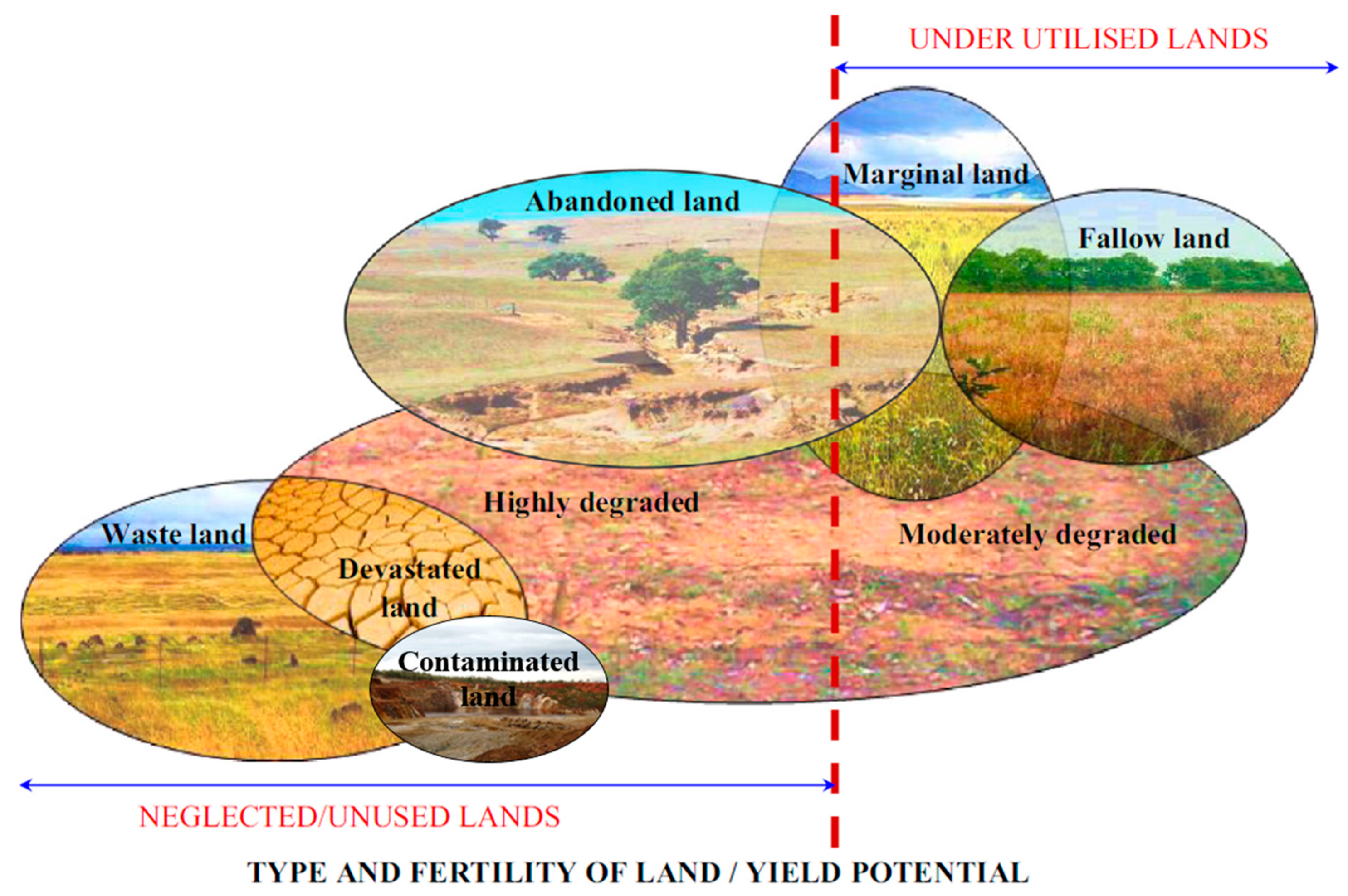
2.2. Low Indirect Land-Use Change (ILUC) Risk Soils
2.3. Colleted Maps
3. Results and Discussions
3.1. Georreferenced Databases on ArcGIS
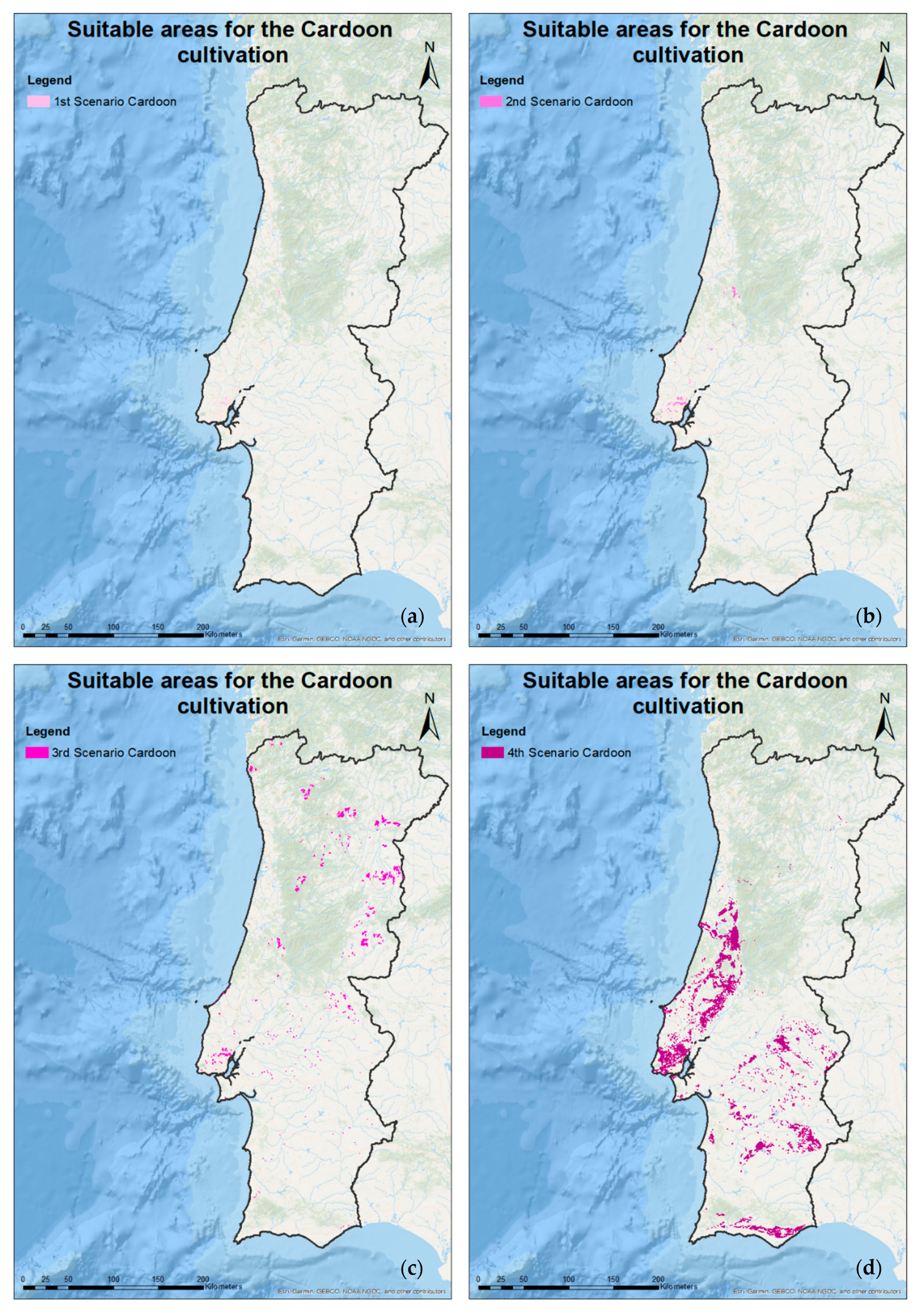
3.1.1. Suitable Areas/Soils to the Cardoon, Miscanthus and Paulownia Cultivation
3.1.2. Suitable Areas/Soils for Microalgae Cultivation
3.1.3. Cultivated Crops (Agricultural/Silviculture) and their Residues with Potential Interest for Portuguese Inland Territory
3.1.4. Estimated Production of Energy Crops
3.2. Publication on Laboratório Nacional de Energia e Geologia – LNEG´s geoportal
4. Conclusions and Recommendations
Supplementary Materials
Author Contributions
Funding
Conflicts of Interest
References and Notes
- The European Parliament and the Council of the European Union. Directive (EU) 2015/1513 of the European Parliament and of the Council of 9 September 2015; Official Journal of the European Union: Brussels, Belgium, 2015; pp. L239/1–L239/29. [Google Scholar]
- Barbosa, B.J.; Fernando, A.L. Production of Energy Crops in Heavy Metals Contaminated Land: Opportunities and Risks. In Land Allocation for Biomass Crops; Li, R., Monti, A., Eds.; Springer: Cham, Switzerland, 2018; pp. 83–102. ISBN 978-3-319-74536-7. [Google Scholar]
- Decreto-Lei n. 152-C/2017; Diário da República n.° 236/2017, 2° Suplemento, Série I de 2017-12-11. pp. 6584-(73)–6584-(88). Available online: https://dre.pt/application/file/a/114336874 (accessed on 26 August 2019).
- Caetano, M.; Marcelino, F.; Igreja, C.; Girão, I. Estatísticas e Dinâmicas Territoriais em Portugal Continental 1995–2007–2010–2015 com Base na Carta de Uso e Ocupação do Solo (COS); Direção-Geral do Território (DGT) Lisboa: Lisboa, Portugal, 2018. [Google Scholar]
- Nunes, L.J.R.; Matias, J.C.O.; Catalão, J.P.S. Biomass in the generation of electricity in Portugal: A review. Renew. Sustain. Energy Rev. 2017, 71, 373–378. [Google Scholar] [CrossRef]
- Ferreira, S.; Monteiro, E.; Brito, P.; Vilarinho, C. Biomass resources in Portugal: Current status and prospects. Renew. Sustain. Energy Rev. 2017, 78, 1221–1235. [Google Scholar] [CrossRef]
- Castillo, C.; Baranzelli, C.; Maes, J.; Zulian, G.; Barbosa, A.; Vandecasteele, I.; Mari-Rivero, I.; Vallecillo, S.; Batista e Silva, F.; Jacobs-Crisioni, C.; et al. An Assessment of Dedicated Energy Crops in Europe under the EU Energy Reference Scenario 2013. Application of the LUISA Modelling Platform-Updated Configuration 2014; EUR 27644; European Union: Brussels, Belgium, 2016. [Google Scholar] [CrossRef]
- Allen, B.; Kretschmer, B.; Baldock, D.; Menadue, H.; Nanni, S.; Tucker, G. Space for Energy Crops–Assessing the Potential Contribution to Europe’s Energy Future; IEEP: London, UK, 2014. [Google Scholar]
- SilvaPlus Espécies Energéticas Herbáceas e Arbustivas. Available online: http://www.silvaplus.com/pt/culturas-energeticas-florestais/especies-energeticas-herbaceas-e-arbustivas/ (accessed on 16 November 2018).
- Gominho, J.; Dolores, M.; Lourenço, A.; Fernández, J.; Pereira, H. Cynara cardunculus L. as a biomass and multi-purpose crop: A review of 30 years of research. Biomass Bioenergy 2018, 109, 257–275. [Google Scholar] [CrossRef]
- Mancini, M.; Lanza Volpe, M.; Gatti, B.; Malik, Y.; Moreno, A.C.; Leskovar, D.; Cravero, V. Characterization of cardoon accessions as feedstock for biodiesel production. Fuel 2019, 235, 1287–1293. [Google Scholar] [CrossRef]
- Fernando, A.L.; Costa, J.; Barbosa, B.; Monti, A.; Rettenmaier, N. Environmental impact assessment of perennial crops cultivation on marginal soils in the Mediterranean Region. Biomass Bioenergy 2018, 111, 174–186. [Google Scholar] [CrossRef]
- Mañas, P.; Castro, E.; de las Heras, J. Application of treated wastewater and digested sewage sludge to obtain biomass from Cynara cardunculus L. J. Clean. Prod. 2014, 67, 72–78. [Google Scholar] [CrossRef]
- Chung, J.; Kim, D. Miscanthus as a Potential Bioenergy Crop in East Asia. J. Crop Sci. Biotechnol. 2012, 15, 65–77. [Google Scholar] [CrossRef]
- Barbosa, B.; Boléo, S.; Sidella, S.; Costa, J.; Duarte, M.P.; Mendes, B.; Cosentino, S.L.; Fernando, A.L.; Fernando, A.L. Phytoremediation of Heavy Metal-Contaminated Soils Using the Perennial Energy Crops Miscanthus spp. and Arundo donax L. Bioenergy Res. 2015, 8, 1500–1511. [Google Scholar] [CrossRef]
- Barbosa, B.; Costa, J.; Fernando, A.L.; Papazoglou, E.G. Wastewater reuse for fiber crops cultivation as a strategy to mitigate desertification. Ind. Crop. Prod. 2015, 68, 17–23. [Google Scholar] [CrossRef]
- Alexopoulou, E.; Casler, M.D.; Christou, M.; Clifton-Brown, J.; Copani, V.; Cosentino, S.L.; Montaño, C.M.D.; Donnison, I.S.; Elbersen, H.W.; Farrar, K.; et al. Perennial Grasses for Bioenergy and Bioproducts; Academic Press: London, UK, 2018; ISBN 9780128129005. [Google Scholar]
- Fernando, A.L.; Godovikova, V.; Oliveira, J.F.S. Miscanthus x giganteus: Contribution to a Sustainable Agriculture of a Future/Present-Oriented Biomaterial. Mater. Sci. Forum Adv. Mater. Forum II 2004, 455, 437–441. [Google Scholar] [CrossRef]
- Oliveira, J.; Duarte, M.; Christian, D.; Eppel-Hotz, A.; Fernando, A.L. Environmental aspects of Miscanthus production. In Miscanthus: For Energy and Fibre; Jones, M.B., Walsh, M., Eds.; James & James (Science Publishers): London, UK, 2001; pp. 172–178. ISBN 9781849710978. [Google Scholar]
- Zhu, Z.H.; Chao, C.J.; Lu, X.Y.; Xiong, Y.G. Paulownia in China: Cultivation and Utilization; Chinese Academy of Forestry Staff, Ed.; Asian Network for Biological Sciences and International Development Research Centre: Singapore, 1986; ISBN 9971845466. [Google Scholar]
- El-Showk, N.; El-Showk, S. The Paulownia Tree an Alternative for Sustainable Forestry; The Farm—Crop Development.org: Rabat, Morocco, 2003. [Google Scholar]
- Direção Nacional das Fileiras Florestais Culturas Energéticas Florestais-Primeira Abordagem do Levantamento da Situação Actual. Available online: http://www2.icnf.pt/portal/florestas/fileiras/resource/doc/biom/biomass-gtce-jun10 (accessed on 16 November 2018).
- Decreto-Lei n. 565/99; Diário da República n.º 295/1999, Série I-A de 1999-12-21; pp. 9100–9115.
- Jiménez, L.; Rodriguez, A.; Ferrer, J.L.; Pérez, A.; Angulo, V. Paulownia, a fast-growing plant, as a raw material for paper manufacturing. Afinidad Barcelona 2005, 62, 100–105. [Google Scholar]
- López, F.; Pérez, A.; Zamudio, M.A.M.; De Alva, H.E.; García, J.C. Paulownia as raw material for solid biofuel and cellulose pulp. Biomass Bioenergy 2012, 45, 77–86. [Google Scholar] [CrossRef]
- Zamudio, M.A.M.; Alfaro, A.; de Alva, H.E.; García, J.C.; García-Morales, M.; López, F. Biorefinery of paulownia by autohydrolysis and soda-anthraquinone delignification process. Characterization and application of lignin. J. Chem. Technol. Biotechnol. 2015, 90, 534–542. [Google Scholar] [CrossRef]
- Yadav, N.K.; Vaidya, B.N.; Henderson, K.; Lee, J.F.; Stewart, W.M.; Dhekney, S.A.; Joshee, N. A Review of Paulownia Biotechnology: A Short Rotation, Fast Growing Multipurpose Bioenergy Tree. Am. J. Plant Sci. 2013, 4, 2070–2082. [Google Scholar] [CrossRef]
- Domínguez, E.; Romaní, A.; Domingues, L.; Garrote, G. Evaluation of strategies for second generation bioethanol production from fast growing biomass Paulownia within a biorefinery scheme. Appl. Energy 2017, 187, 777–789. [Google Scholar] [CrossRef]
- Vega, D.J.; Dopazo, R.; Ortiz, L. Manual de Cultivos Energéticos; Vigo University: Vigo, Spain, 2010. [Google Scholar]
- Rawat, I.; Kumar, R.R.; Mutanda, T.; Bux, F. Biodiesel from microalgae: A critical evaluation from laboratory to large scale production. Appl. Energy 2013, 103, 444–467. [Google Scholar] [CrossRef]
- Raheem, A.; Azlina, W.A.K.G.W.; Tau, Y.H.; Danquah, M.K. Thermochemical conversion of microalgal biomass for biofuel production. Renew. Sustain. Energy Rev. 2015, 49, 990–999. [Google Scholar] [CrossRef]
- Brennan, L.; Owende, P. Biofuels from microalgae-A review of technologies for production, processing, and extractions of biofuels and co-products. Renew. Sustain. Energy Rev. 2010, 14, 557–577. [Google Scholar] [CrossRef]
- El Bassam, N. Handbook of Bioenergy Crops: A Complete Reference to Species, Development and Applications, 1st ed.; Earthcan Ltd.: London, UK, 2010; ISBN 9781138975712. [Google Scholar]
- Gonçalves, M. Aproveitamento da Biomassa Florestal para Fins Energéticos (o início de um novo ciclo para a floresta portuguesa)—Potencial das Culturas Energéticas. Feira Nac. Agric. 2007. [Google Scholar]
- AFG-Asociación Forestal de Galicia ECAS-Cultivos Energéticos en el Espacio Atlántico. Available online: http://enersilva.navegantes.info/areasubir/libros/FolletoECAS.pdf (accessed on 17 October 2017).
- Almeida, A.R. Avaliação do potencial ecológico para a influência do perímetro de rega do Alqueva. Master’s Thesis, Engenharia Agronómica—Agro-pecuária, Universidade Técnica de Lisboa, Lisboa, Portugal, 2009. [Google Scholar]
- Edrisi, S.A.; Abhilash, P.C. Exploring marginal and degraded lands for biomass and bioenergy production: An Indian scenario. Renew. Sustain. Energy Rev. 2016, 54, 1537–1551. [Google Scholar] [CrossRef]
- Olsson, L.; Barbosa, H.; Bhadwal, S.; Cowie, A.; Delusca, K.; Flores-Renteria, D.; Hermans, K.; Jobbagy, E.; Kurz, W.; Li, D.; et al. Chapter 4: Land Degradation; Special Report on Climate Change and Land of Intergovernmental Panel on Climate Change (IPCC); IPCC: Geneva, Switzerland, 2019. [Google Scholar]
- United Nations Convention to Combat Desertification (UNCCD). United Nations Convention to Combat Desertification in Those Countries Experiencing Serious Drought and/or Desertification, Particularly in Africa; UNCCD: Paris, France, 1994. [Google Scholar]
- Mirzabaev, A.; Wu, J.; Evans, J.; Garcia-Oliva, F.; Hussein, I.A.G.; Iqbal, M.M.; Kimutai, J.; Knowles, T.; Meza, F.; Nedjraoui, D.; et al. Chapter 3: Desertification; Special Report on Climate Change and Land of Intergovernmental Panel on Climate Change (IPCC); IPCC: Geneva, Switzerland, 2019; Volume 21. [Google Scholar]
- ICNF Cartografia de Apoio ao PDR 2020-Suscetibilidade dos Solos à Desertificação. Available online: http://www2.icnf.pt/portal/pn/biodiversidade/ei/unccd-PT/pancd/o-pancd-2014-2020/cartografia-apoio-pdr2020 (accessed on 7 October 2018).
- Empresa de Desenvolvimento Mineiro (EDM) Shapefiles sent by email with contaminated areas from EDM 2018.
- Milbrandt, A.; Overend, R.P. Assessment of Biomass Resources from Marginal Lands in APEC Economies; Asia-Pacific Economic Cooperation (APEC): Singapore, 2009. [Google Scholar]
- Direção-Geral do Território Carta de Uso e Ocupação do Solo de Portugal Continental Para 2010–(COS2010v1.0). Available online: mapas.dgterritorio.pt/inspire/atom/CDG_COS2015v1_Continente_Atom.xml (accessed on 7 January 2019).
- ECA. Desertification in the EU. Background Paper; European Court of Auditors (ECA)—Guardians of the EU Finances: Luxembourg, 2018. [Google Scholar]
- CABI Invasive Species Compendium-Cynara Cardunculus (Cardoon). Available online: https://www.cabi.org/isc/datasheet/17584 (accessed on 7 March 2019).
- CABI Invasive Species Compendium-Paulownia Tomentosa (Paulownia). Available online: https://www.cabi.org/isc/datasheet/39100 (accessed on 7 March 2019).
- Laboratório Nacional de Energia e Geologia—LNEG Projeto Converte. Available online: http://geoportal.lneg.pt/geoportal/mapas/index.html?mapa=converte (accessed on 25 September 2019).


| Biomass | Binomial Name | Species and Culture Type | Productivity/Yield | Growth Rate | Harvest | Number of Harvests/Year |
|---|---|---|---|---|---|---|
| Cardoon | Cynara cardunculus | Herbaceous (lignocellulosic and oleaginous type) | 10 to 25 t/year, with 500 mm/year rainfall in the Mediterranean Region [33]. In the 1st year, it is possible to obtain 10 t (dry matter)/ha and in the 2nd year, 12–15 t (dry matter)/ha with 400 and 550 mm/year of rainfall during the vegetative period [9] | Life span from 10 to 15 years [33] and crop height up to 2 m [9] | Harvest occurs between July and September, with moisture in between 10% and 15% and before seed dissemination [33] | 1 [33] |
| Miscanthus | Miscanthus x giganteus | Herbaceous (lignocellulosic type) | From 15 [34] to 30 t/ha of dry matter, with precipitation higher than 500 mm/year [18] | Life span between 10 and 15 years (in some cases can reach up to 20 years [9]) achieving maturity after 2 or 3 years. The stems in the 1st year, with favorable summer temperatures, reach a height of 1.5 to 2 m (sometimes up to 3 m [9]), with higher yields in Southern Europe (water cannot be a limiting factor) [18] | Rhizomes are planted between march and may (in Europe and depending on the weather). Harvesting is performed when the dry matter content is high [18] (usually in autumn [34] or end of winter) [18] | 1 [18] |
| Paulownia | Paulownia tomentosa | Woody (lignocellulosic type) | 35 to 45 t/ha/year (30% moisture) with minimum precipitation of 500 mm/year. Planting density is on average 1600 trees/ha [22] | It is possible to reach a height of 20 m in rotation cycles of 4 and 5 years [22] | - | - |
| Microalgae | - | Aqueous medium | 55 t/ha year (conservative) | Achievable biomass doubling time of 7h for mass culture | Daily | 365 |
| Biomass | Insolation | Precipitation | Temperature | Land Steepness | Soil Type | Weather Limitations or other Aspects |
|---|---|---|---|---|---|---|
| Cardoon | - | The highest demand of water (precipitation higher than 450 mm) is from autumn until early spring [35], therefore, it can growth in dry areas [34]. However, with lower rainfall, a decrease in productivity is observed [35] | It supports temperatures down to −5 °C, as long as it has developed four leaves [33] | The maximum value between 8 and 15% [36] | It supports pH above 6 in the soil. Preference for well drained deep soils, with water retention in the subsoil between 1 and 3 m [33]. It is a little sensitive to stony conditions [35] | Winter frost causes leaf death, however, it survives and recovers as soon this period ends. Requires water (in the Mediterranean) in the late spring [33]. It isn´t very exigent in relation to the type of soil and water. It requires high temperature climate [34] |
| Miscanthus | - | It presents moderate needs, therefore, rainfall has to exceed 500 mm [18] | It can grow with soil temperature above 8 °C. Negative temperatures can cause rhizomes death [18] | The maximum value between 8 and 15% [36] | Optimum pH between 5.5 and 7.5. Sandy soils: maximum productivity attained in 3 years. Loamy or clay soils: higher yields obtained after 5 years. Preference for loamy-sandy soils (up to 10% clay, well-aerated and with high water retention capacity) with high organic matter content [18] | - |
| Paulownia | - | It requires minimum average precipitation of 500 mm [22] | It supports cold very well (down to −17 °C) and heat (up to 45 °C) [22] | It stands slope up to 25% [22] | It requires a soil pH of 5.5 to 8. Prefers well-drained soils, with water table higher than 2 or 2.5 m and not very clayey. It adapts to a great variety of climates and soils and resists moderately periods of dryness between the 1st and 2nd year [22] | It resists fires very well, being a species free from pests and diseases [22] |
| Microalgae | Elevated | Not relevant a | From 10 to 40 °C | - | Not relevant a | Not relevant a |
| Maps | Crops | 1st Scenario | 2nd Scenario | 3rd Scenario | 4th Scenario |
|---|---|---|---|---|---|
| Districts | 3 species | Aveiro; Beja; Braga; Bragança; Castelo Branco; Coimbra; Évora; Faro; Guarda; Leiria; Lisboa; Portalegre; Porto; Santarém; Setúbal; Viana do Castelo; Vila Real; Viseu | |||
| Land Use and Land Cover - COS 2010 | 3 species | 3.2.1.01.1 Natural herbaceous vegetation; 3.2.2.01.1 Dense bushes; 3.2.2.02.1 Low dense bushes; 3.2.3.01.1 Dense sclerophyte vegetation; 3.2.3.02.1 Sclerophyte vegetation not very dense; 3.2.4.07.1 Other woody formations; 3.3.3.01.1 Vegetation sparse | × | ||
| Corine Land Cover - CLC 2012 | 3 species | Bushes; Sclerophyllic vegetation; Sparse vegetation; Natural herbaceous vegetation | × | ||
| COS 2015 | 3 species | Natural herbaceous vegetation; Bushes; Spaces discovered or with little vegetation | × | ||
| Temperature | Cardoon | Equal or superior than 7.5 °C | Equal or superior than 0 °C | Equal or superior than 7.5 °C | |
| Miscanthus | Equal or superior than 10 °C | ||||
| Paulownia | Equal or superior than 0 °C | ||||
| Precipitation | Cardoon | Equal or superior than 500 mm/year | Equal or superior than 400 mm/year | Equal or superior than 500 mm/year | |
| Miscanthus | Equal or superior than 500 mm/year | ||||
| Paulownia | |||||
| Frost | Cardoon | Up to 60 days | |||
| Miscanthus | |||||
| Paulownia | Up to 80 days | ||||
| Land steepness | Cardoon | 0–3%; 3–5%; 5–8%; 8–12%; 12–16% | |||
| Miscanthus | × | 0–3%; 3–5%; 5–8%; 8–12%; 12–16% | |||
| Paulownia | 0–3%; 3–5%; 5–8%; 8–12%; 12–16%; 16–25% | ||||
| Soil texture | Cardoon | Fine; Median | Fine; Median; Coarse | Fine; Median | |
| Miscanthus | Coarse | ||||
| Paulownia | Fine; Median | ||||
| Soil pH | Cardoon | 6.0–6.5; 6.5–7.0; 7.0–7.5; 6.0–7.5; 7.5–8.0; 8.0–8.5; ≥ 7.5 | 4.5–5.0; 5.0–5.5; 5.5–6.0; 4.5–6.0; 6.0–6.5; 6.5–7.0; 7.0–7.5; 6.0–7.5; 7.5–8.0; 8.0–8.5; ≥7.5 | 6.0–6.5; 6.5–7.0; 7.0–7.5; 6.0–7.5; 7.5–8.0; 8.0–8.5; ≥7.5 | |
| Miscanthus | 5.5–6.0; 6.0–6.5; 6.5–7.0; 7.0–7.5; 6.0–7.5 | 5.5–6.0; 4.5–6.0; 6.0–6.5; 6.5–7.0; 7.0–7.5; 6.0–7.5 | 5.5–6.0; 6.0–6.5; 6.5–7.0; 7.0–7.5; 6.0–7.5 | ||
| Paulownia | 5.5–6.0; 6.0–6.5; 6.5–7.0; 7.0–7.5; 6.0–7.5; 7.5–8.0; ≥7.5 | 4.5–5.0; 5.0–5.5; 5.5–6.0; 4.5–6.0; 6.0–6.5; 6.5–7.0; 7.0–7.5; 6.0–7.5 | 5.5–6.0; 6.0–6.5; 6.5–7.0; 7.0–7.5; 6.0–7.5; 7.5–8.0; ≥7.5 | ||
| Soil thickness (cm) | Cardoon | 0–10; 0–25; 0–30; 10–25; 25–50; 30–50; 50–100; >100 | |||
| Miscanthus | 0–10; 0–25; 0–30; 10–25 | 0–10; 0–25; 0–30; 10–25; 25–50 | 0–10; 0–25; 0–30; 10–25 | ||
| Paulownia | 0–10; 0–25; 0–30; 10–25; 25–50; 30–50; 50–100; >100 | ||||
| Ecological Soil Value | 3 species | Very reduced (E.V 1); Reduced (E.V 2) | Very reduced (E.V 1); Reduced (E.V 2); Variable (E.V 3) | ||
| Current Permeability | Cardoon | Moderate to High-Class 4; High-Class 5 | Very reduced (E.V 1); Reduced (E.V 2); Variable (E.V 3) | ||
| Miscanthus | Low-Class 1 | Moderate-Class 3; Moderate to High-Class 4; High-Class 5 | |||
| Paulownia | Moderate to High-Class 4; High-Class 5 | Low-Class 1; Low to Moderate-Class 2; Moderate-Class 3 | |||
| Natural and semi-natural vegetation with conservation value | Cardoon | Very low; Low | Very low; Low; Moderate | × | |
| Miscanthus | |||||
| Paulownia | Very low; Low | ||||
| Soil-morphological aptitude to irrigated agriculture | Cardoon | Without aptitude-25.3%; Low-34.7% | Without aptitude-25.3%; Low-34.7%; Moderate-4.5% | ||
| Miscanthus | |||||
| Soil-morphological aptitude to silviculture | Paulownia | Forestry not recommended-15.7% | Forestry not recommended-15.7%; Undifferentiated silviculture-20.3% | ||
| Unprotected areas | 3 species | Zones that not included the protected areas, namely, Important Community Sites (SIC); Protected Special Zones (ZPE); Protected Areas National Network (RNAP); Ramsar Sites (wetlands) and Biosphere Reserve | |||
| Soil susceptibility to desertification | Cardoon | 3-High; 4-Very High | 2-Moderate; 3-High; 4-Very High | ||
| Miscanthus | |||||
| Paulownia | 3-High; 4-Very High | ||||
| Classification of soils according to each mine group | 3 species | As (Others); Asbestos (Asbestos); Au (Gold); Au, Ag (Gold); Ba, Pb, W, Sn (Tin and Wolfram); Barium (Polymetallic); Coal (Coal); Cu (Basic Metals); Cu, Pb, Ag (Basic Metals); Cu, Pb, Zn (Polymetallic); Fe (Iron and Manganese); Fe, Cu, Pb, Zn (Iron and Manganese); Mn (Iron and Manganese); Pb (Basic Metals); Pb, Au (Basic Metals); Pb, Zn (Basic Metals); Pb, Zn, Ag (Basic Metals); Pb, Zn, Ag (Polymetallic); Qz, Felds (Others); Ra (Radioactive); Ra, U (Radioactive); Sb (Others); Sb, Au (Gold); Sn (Tin and Wolfram); Sn, Nb, Ta, W (Tin and Wolfram); Sn, W (Tin and Wolfram); Sn, W, Ti (Tin and Volphamium); Sn, W, Ti (Tin and Volphamium); W (Tin and Wolfram); W, As (Tin and Wolfram); W, Mo (Tin and Wolfram); W, Sb, Au (Gold); W, Sn (Tin and Wolfram); W, Sn, Li (Tin and Wolfram); W, Sn, Qz (Tin and Wolfram); Zn, Pb (Basic Metals) | |||
| Wastewater Treatment Plant - WWTP capacity (p.e—population equivalent) | 3 species | 400–31,500; 31,500–97,200; 97,200–216,000; 216,000–400,000; 400,000–920,000 | |||
| Treatments applied to wastewater facilities | 3 species | Primary; Secondary; Tertiary | |||
| Maps | 1st Scenario | 2nd Scenario | 3rd Scenario | 4th Scenario |
|---|---|---|---|---|
| Districts | Aveiro; Beja; Braga; Bragança; Castelo Branco; Coimbra; Évora; Faro; Guarda; Leiria; Lisboa; Portalegre; Porto; Santarém; Setúbal; Viana do Castelo; Vila Real; Viseu | |||
| Land Use and Land Cover - COS 2010 | 3.3.2.01.1 bare rock | × | ||
| Corine Land Cover - CLC 2012 | Bare rock | × | ||
| Insolation | Superior than 2500 h | |||
| Temperature | Equal or superior than 10 °C | |||
| Municipalities with CO2 production in the energy sector | 28.184080–224.886097; 224.886098–345.873456; 345.873457–974.625606; 974.625607–3602.772540; 3602.772541–8665.540705 | |||
| Municipalities with CO2 production in the industrial sector | 26.595721–82.594012; 82.594013–226.494754; 226.494755–551.636051; 551.636052–1481.167615; 1481.167616–2788.265732 | |||
| Pollutant Release and Transfer Register (PRTR) | Steel; Biomass; Hydraulic lime; Non-hydraulic lime; Coal; Iron; Fuel oil; Natural gas; Kraft with bleaching; Unbleached Kraft; No specific (are just of interest the identified as Paste production, Manufacture of refined petroleum products; Manufacture of industrial gases; Manufacture of cement and iron and steel industry and manufacture of ferro-alloys); Other [it is only of interest Paste production, Manufacture of paper and paperboard (except corrugated paper); Manufacture of paper and paper products for domestic and sanitary purposes; Manufacture of refined petroleum products; Manufacture of petroleum products from waste; Manufacture of cement and production of thermal origin electricity)]; Other-Biofuels; Other-Biodiesel; Other-Co-incineration; Other-Incineration of hazardous waste; Other-Fuel Treatment; Printing and writing paper; Paper, cardboard and packaging; Bleached sulphite; Tissue (paper mills); Glass packaging; Domestic glass and Oils (Biodiesel Manufacturing Only) | |||
| Land steepness | Superior than 25% | |||
| Presence of physical obstacles | P-Stony phase; R2-Rock outcrops exceeding 25–40% of the area; R3-Rock outcrops exceeding 50–70% of the area | |||
| Unprotected areas | × | Zones that not included the protected areas, namely, Important Community Sites (SIC); Protected Special Zones (ZPE); Protected Areas National Network (RNAP); Ramsar Sites (wetlands) and Biosphere Reserves | × | |
| Wastewater Treatment Plant - WWTP capacity (p.e—population equivalent) | 400–31,500; 31,500–97,200; 97,200–216,000; 216,000–400,000; 400,000–920,000 | |||
| Treatments applied to Wastewater Facilities | Primary; Secondary; Tertiary | |||
| Maps | 1st Scenario | 2nd Scenario | 3rd Scenario | ||
|---|---|---|---|---|---|
| COS 2010 | CLC 2012 | COS 2015 | |||
| Districts | Aveiro; Beja; Braga; Bragança; Castelo Branco; Coimbra; Évora; Faro; Guarda; Leiria; Lisboa; Portalegre; Porto; Santarém; Setúbal; Viana do Castelo; Vila Real; Viseu | ||||
| Land Use and Land Cover - COS 2010 | All the parameters that correspond to the Agriculture (except 2.1.1.02 Greenhouses and nurseries), the areas classified as Forest (without the criteria that include aspects related to burned areas) and all the lands that correspond the agroforestry systems (SAF) | × | × | ||
| Corine Land Cover - CLC 2012 | Agriculture with natural and semi-natural spaces; Rice paddies; Temporary irrigated crops; Temporary rainfed crops; Temporary crops and/or pastures associated with permanent crops; Open forests, cuts and new plantations; Hardwood forests; Softwood forests; Mixed forests; Olive groves; Orchards; Agro-forestry systems; Cultural systems and complex parcel and Vineyards. | × | Agriculture with natural and semi-natural spaces; Rice paddies; Temporary irrigated crops; Temporary rainfed crops; Temporary crops and/or pastures associated with permanent crops; Open forests, cuts and new plantations; Hardwood forests; Softwood forests; Mixed forests; Olive groves; Orchards; Agro-forestry systems; Cultural systems and complex parcel and Vineyards. | × | |
| COS 2015 | Criteria relating to agriculture as rainfed and irrigated temporary crops were considered; Rice paddies; Vineyards; Orchards; Olive groves; Temporary crops and/or pastures associated with permanent crops; Cultural systems and complex parcel and lastly, Agriculture with natural and semi-natural spaces. The SAFs of Cork oak; Holm oak; Other oaks; Stone pine; Other species; Cork oak with holm oak and Other mixed. The forest areas of Cork oak; Holm oak; Other oaks; Chestnut; Eucalyptus; Invasive species; Other hardwood; Maritime pine; Stone pine and Other | × | × | Criteria relating to agriculture as rainfed and irrigated temporary crops were considered; Rice paddies; Vineyards; Orchards; Olive groves; Temporary crops and/or pastures associated with permanent crops; Cultural systems and complex parcel and lastly, Agriculture with natural and semi-natural spaces. The SAFs of Cork oak; Holm oak; Other oaks; Stone pine; Other species; Cork oak with holm oak and Other mixed. The forest areas of Cork oak; Holm oak; Other oaks; Chestnut; Eucalyptus; Invasive species; Other hardwood; Maritime pine; Stone pine and Other | |
| Unprotected areas | Zones that not included the protected areas, namely, Important Community Sites (SIC); Protected Special Zones (ZPE); Protected Areas National Network (RNAP); Ramsar Sites (wetlands) and Biosphere Reserves | Zones that included the protected areas, namely, Important Community Sites (SIC); Protected Special Zones (ZPE); Protected Areas National Network (RNAP); Ramsar Sites (wetlands) and Biosphere Reserves | |||
| Energy Crops/Species | Scenario | Area (km2) | Area (kha) | % of the Obtained Area in Mainland Portugal | Minimum Productivity (t/ha) | Maximum Productivity (t/ha) | Minimum Production (kt) | Maximum Production (kt) | |
|---|---|---|---|---|---|---|---|---|---|
| 🌷 Cardoon | 1st | 5.21 | 0.521 | 0.01 | 10 | 15 | 5 | 8 | |
| 2nd | 13.82 | 1 | 0.02 | 14 | 21 | ||||
| 3rd | 128.84 | 13 | 0.14 | 129 | 193 | ||||
| 4th | 723.13 | 72 | 0.81 | 723 | 1085 | ||||
| 🌾 Miscanthus | 1st | 0.00 | 0 | 0.00 | 15 | 30 | 0.001 | 0.002 | |
| 2nd | 0.04 | 0.004 | 0.00 | 0.054 | 0.109 | ||||
| 3rd | 0.17 | 0.017 | 0.00 | 0.262 | 0.523 | ||||
| 4th | 8.74 | 0.874 | 0.01 | 13 | 26 | ||||
| 🌳 Paulownia | 1st | 0.03 | 0.003 | 0.00 | 35 | 45 | 0.105 | 0.134 | |
| 2nd | 7.64 | 0.764 | 0.01 | 27 | 34 | ||||
| 3rd | 9.71 | 0.971 | 0.01 | 34 | 44 | ||||
| 4th | 80.75 | 81 | 0.91 | 2834 | 3644 | ||||
 Microalgae Microalgae | 1st | 293.95 | 29 | 0.33 | 55 | 1617 | |||
| 2nd | 234.77 | 23 | 0.26 | 1291 | |||||
| 3rd | 234.69 | 23 | 0.26 | 1291 | |||||
| 4th | 293.87 | 29 | 0.33 | 1616 | |||||
| 🌄 Cultivated agricultural/silvicultural species | 1st | 40,280.43 | 4028 | 45.25 | |||||
| 2nd | 55,734.56 | 5573 | 62.61 | ||||||
| 3rd | COS 2010 | 64,761.63 | 6476 | 72.75 | |||||
| CLC 2012 | 73,664.68 | 7366 | 82.76 | ||||||
| COS 2015 | 65,316.13 | 6532 | 73.38 | ||||||
© 2020 by the authors. Licensee MDPI, Basel, Switzerland. This article is an open access article distributed under the terms and conditions of the Creative Commons Attribution (CC BY) license (http://creativecommons.org/licenses/by/4.0/).
Share and Cite
Abreu, M.; Reis, A.; Moura, P.; Fernando, A.L.; Luís, A.; Quental, L.; Patinha, P.; Gírio, F. Evaluation of the Potential of Biomass to Energy in Portugal—Conclusions from the CONVERTE Project. Energies 2020, 13, 937. https://doi.org/10.3390/en13040937
Abreu M, Reis A, Moura P, Fernando AL, Luís A, Quental L, Patinha P, Gírio F. Evaluation of the Potential of Biomass to Energy in Portugal—Conclusions from the CONVERTE Project. Energies. 2020; 13(4):937. https://doi.org/10.3390/en13040937
Chicago/Turabian StyleAbreu, Mariana, Alberto Reis, Patrícia Moura, Ana Luisa Fernando, António Luís, Lídia Quental, Pedro Patinha, and Francisco Gírio. 2020. "Evaluation of the Potential of Biomass to Energy in Portugal—Conclusions from the CONVERTE Project" Energies 13, no. 4: 937. https://doi.org/10.3390/en13040937
APA StyleAbreu, M., Reis, A., Moura, P., Fernando, A. L., Luís, A., Quental, L., Patinha, P., & Gírio, F. (2020). Evaluation of the Potential of Biomass to Energy in Portugal—Conclusions from the CONVERTE Project. Energies, 13(4), 937. https://doi.org/10.3390/en13040937