Abstract
The commonly used approach to predict and evaluate the wind risk in Peninsular Malaysia is to employ the basic wind speed (Vs) hazard map, which underestimates the real damage due to the limitation of factors considered by the current map. This paper aimed to develop a new wind hazard map for Peninsular Malaysia based on the site wind speed (Vsite) rather than the Vs using the Geographical Information System. The development of the Vsite map considered the effects of the Land Use Land Cover (LULC) and the topography conditions that were not taken into consideration by the Malaysian Standard during the development of the Vs map. The statistical analysis proved that the wind hazard in Peninsular Malaysia is directly proportional to the LULC and inversely proportional to the Hill Shape Multiplier. In addition, the results showed that the existing Vs map underrated the wind hazard in Peninsular Malaysia by almost 9.02% to 17.79% compared to the developed Vsite map. Therefore, the use of the newly developed map to evaluate the wind hazards will significantly enhance the assessment, and the new map has the potential to be incorporated into the Malaysian Standard for this purpose.
1. Introduction
Wind may cause severe damage to property, loss of life, and other catastrophic events. According to Tamura and Cao [1], severe winds were the main cause of death in the previous decade compared to other natural disastrous events. Thus, it is essential to fully understand what factors alleviate the windstorm frequency and intensity so that effective risk management methods can be established [2]. Paton [3] suggested that reconsidering the basic assumptions of the existing disaster risk methods should be an urgent matter, especially with the recent advances in the techniques of measurement and analysis. This requires wind engineering experts from all over the world to join their forces and produce effective measurements to help minimize the wind-related hazards [1].
Malaysia is an Asian country located near the equator and is well-known for its rainforests. This makes it extremely important to investigate its wind flow pattern, which is mainly controlled by two major monsoon periods, namely the northeast monsoon (November to March) and the southwest monsoon (May to September) [4]. A specific period between the two major monsoons (April and October) is called the intermonsoon, in which frequent thunderstorm events occur, causing stronger and gustier windstorms than those of the northeast and southwest monsoons. These windstorms are classified within the meteorological disaster subgroup [5].
The International Disaster Database (EM-DAT) [6] classified windstorms in 2004 as one of the top 10 natural events in Malaysia. Windstorms killed 270 individuals in the state of Sabah on 26 December 1996, and were responsible for the suffering of more than 40,000 people on the East Coast of Peninsular Malaysia on 6 November 2004. Windstorm events have always been on the Malaysian news, and Table 1 presents the disasters and casualties caused by windstorms in Malaysia between 1960 and 2005 as reported by EM-DAT [6]. EM-DAT [6] also reported that seven major catastrophic events caused by windstorms occurred between 1960 and 2016: Two tropical cyclones, a convection storm, and four other storm types. In addition, Bachok et al. [7] stated that windstorm occurrences in Malaysia between 2000 and 2012 occurred in 681 different locations and resulted in a financial loss that exceeded 1M USD.

Table 1.
Windstorm Disaster in Malaysia between 1960–2005 [6].
The consideration of all design factors plays a vital role in efficiently mitigating the damage of windstorm [7,8,9]. Wan Chik et al. [8] investigated the damage of windstorms in Malaysia between 2007 and 2012 based on location. They found that most of the damage occurred in the Northern Region of Peninsular Malaysia and at definite locations. They also concluded that the severity of the windstorm damage increased from one year to another, which was also supported by Majid et al. [9]. Majid et al. [9] found that the windstorm in 2010 killed 3 people, injured 30, and destroyed 1012 houses (roofs) in Peninsular Malaysia. Figure 1 depicts the damage cases reported by Bachok et al. [7] throughout the country between 2000 and 2012, employing both location and date. It is noticed that the highest number of windstorms in Northern, Southern, and Central Regions took place between March and April, which is the transition period between the two monsoons. However, the windstorms in the East Coast Region peaked between August to September. Hence, the study showed that windstorms in Malaysia happen all the year. However, they are most frequent during the transition of the monsoon season.
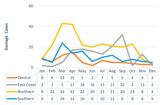
Figure 1.
Windstorm occurrence based on location and date between 2000 and 2012 in Peninsular Malaysia.
In the field of wind engineering, the wind risk for any specific site is usually indicated based on the potential wind speed at that site. A few wind hazard maps have been constructed utilizing the basic wind speed (Vs) to determine the wind load exerted on a structure before the consideration of other factors, like the altitude and the effects of the topographic and aerodynamic shape factors. The drawback of these maps is that they are assessed using the probabilistic method of the past recorded wind speed data, which may lead to the underestimation of the wind speed risk due to the incompetent interpretation of the real potential of wind speed. For example, the Terrain Height Multiplier (Mz,cat ) related to the condition of the Land Use Land Cover (LULC), as well as the Hill Shape Multiplier (Mh) of the topographical condition, may increase. The Malaysian Standard (MS1553:2002) [10] divides Vs of Peninsular Malaysia into two main zones on the map. However, the accuracy of estimating the potential risk is questionable, since the map interpolation does not rely on a spatial analysis technique.
As mentioned earlier, Vs is denoted as potential of wind speed for a specific location without considering the effect of the geographical factors. However, the potential of wind speed is more realistic when the geographical factors are considered because the wind changes its speed characteristics based on the nature of the terrain. Thus, the wind speed that considers the effects of both LULC and the topographical conditions is called site wind speed (Vsite). The MS1553:2002 [10] employs Vsite at some specific locations by multiplying Vs with Mz,cat and Mh. However, to determine Vs in places other than the specific locations, the nearest station must be referred to. Like the previous method, this method is highly prone to inaccuracy in the evaluation of the risk.
Therefore, this study aimed to construct a wind hazard map for areas of Peninsular Malaysia that are not considered as a reference in the MS1553:2002 [10] by considering the Vsite data (LULC and topographic condition) to provide reliable information regarding the wind potential risk at these locations. The potential of wind hazard was uniquely established via spatial analysis techniques. Thus far, a few studies [11,12] developed wind hazard maps based on Vsite data. However, their maps were not validated with any existing studies. For this reason, the constructed hazard map in this study will be verified with past recorded damages.
2. Research Methodology
2.1. The Location of the Study
The selected location for this study was Peninsular Malaysia (Figure 2), with a total area of 130,590 km2, which is still within the hazard assessment range of recommended sizes by Van Westen [13]. For the sake of this study, Peninsular Malaysia was divided into four regions:
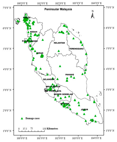
Figure 2.
Selected area of study.
- Northern Region: Perlis, Kedah, Pulau Pinang, Perak
- East Coast Region: Kelantan, Terengganu, Pahang
- Central Region: Selangor, Kuala Lumpur
- Southern Region: Negeri Sembilan, Melaka, Johor
2.2. The Wind Hazard Map Development
The construction of the wind hazard map involved several stages, as explained in this section.
2.2.1. Basic Wind Speed Map
The first phase of the study commenced by adopting a qualitative approach to gather data from the existing recorded windstorm damages. After all the data was collected, the wind hazard map using the site wind speed (Vsite) was produced. Vsite was calculated using the following Equation:
The basic wind speed data employed in the current study were provided by the Malaysian Meteorological Department (MMD) Station as presented in Table 2. All the provided wind speed data was measured at a height of 10 m for a 50-year return period. It is worth mentioning that the 50-year return period was adopted throughout the whole study. According to Sundaraj [14] and Mornet et al. [15], the value of the basic wind speed is significantly affected by the length of the historical wind speed data, and the longer the period, the better the assessment. Furthermore, the height of 10 m is the standardized reference height all over the world [16]. The average time of the gust wind speed measurement by the MMD is three seconds. It is worth mentioning that the basic wind speed (Vs) data was provided by the MMD from 20 different stations. The wind hazard map was developed using the Geographic Information Systems (GIS), which has the capability to interpolate the wind speed data via various statistical methods. The study also employed spatial interpolation methods for the prediction of Vs at the investigated locations, and the spatial interpolation was generated using the Inverse Distance Weighting (IDW) techniques as used by previous studies [17,18,19]. The IDW method calculates the assigned values to the unknown points with the weighted average of the values available at the known points. The weighed value is basically the inverse of the distance raised to a power. The general form of finding an interpolated value at a given point using IDW is presented in Equation (2):
where zu is the unknown value of estimated at u, zi is the attributed value at control point i, diu is the distance between points i and u, s is the number of control points used in estimating, and k is a factor.
Table 2.
The 50-year return period basic wind speed in Peninsular Malaysia.
2.2.2. Terrain Height Multiplier Mapping
To map the area terrain, the LULC map data was used as input and categorized based on the terrain category. In order to estimate Mh, a terrain classification map was developed based on the obstructions of the terrain as stated in MS 1553:2002 [10]. The Mz,cat coefficient map was generated from the reclassification of the LULC to the weighted scale, which relies on the coefficient factors.
2.2.3. Topographic Wind Multipliers
The Hill Shape Multiplier (Mh) was obtained based on the slope category in accordance with MS 1553:2000 [10]. The slope category of the area was generated using the Digital Elevation Models (DEM) data, as well as the Shuttle Radar Topography Mission (SRTM) data. The slope category was generated in accordance to Table 3.
Table 3.
Hill shape Multiplier (Mh).
2.3. Wind Hazard Maps Validation
To validate and evaluate the performance of the four developed wind hazard maps, both past damage and statistical analysis were used. The first map was developed based on Vs, the second was based on Vsite, and the remaining maps (third and fourth) were based on the average Vsite value according to district and subdistrict. The main purpose of adopting the statistical analysis as a verification method was to compare the performance of Vs and Vsite maps. Histogram analysis, skewness analysis, and Cumulative Distribution Function (CDF) were chosen to assess the frequency and probability of the damages based on their level of hazard. It should be noted that, in this study the wind hazard was defined as the wind speed value, which was also used by Rose et al. [20] to evaluate wind turbine performance against hurricane hazard.
2.3.1. Histogram Analysis
The histogram was first introduced in 1895 by Karl Pearson, and it is an accurate representation of the distribution of the numerical data. It can give a rough estimation of the density of a continuous variable and can be thought of as a kernel density estimation, since it uses a kernel to yield a smoother probability density function, which precisely reflects the distribution of the underlying variable. The histogram is defined as
where n is the number of observations, k is the total number of bins, and mi is the histogram value.
In a more general mathematical form, it can be said that a histogram is a function “mi“, which counts the number of observations that falls into each of the separate bins, while the graph of a histogram is merely one way to represent a histogram. Moreover, a cumulative histogram counts the cumulative cases over the range of cases. Equation (4) defines the histogram in a mathematical function.
where Mi is the cumulative histogram and mi is the histogram value. A cumulative histogram is a plot that counts the cumulative number of observations in all the bins up to the specified bin. This is the basis of producing CDF.
2.3.2. Skewness Analysis
The skewness analysis was performed to view the tendency of the wind speed value against the location of damage. Skewness is a symmetry measure, and it was calculated as follows:
where is the mean, Mo is the mode, and is the standard deviation. For a normal distribution, the skewness is always zero. However, the non-normal distribution skewness could be positive or negative.
2.3.3. Cumulative Distribution Function
The cumulative distribution function (CDF) is a function that provides the probability associated with a function, and it is suitable for comparisons of multiple datasets. It was employed in this study to visualize the performance of the developed wind hazard maps and to display the probability value for a specific target or return value. The cumulative distribution function is defined as the integral of its probability density function fX:
3. Results
3.1. Windstorm Database
All the archived wind damages and trends data from 2009 until 2016 were examined and analyzed according to the geographical location, date, and time. A total of 289 windstorm cases occurred during this period were assigned to the place of occurrence as depicted in Figure 3.
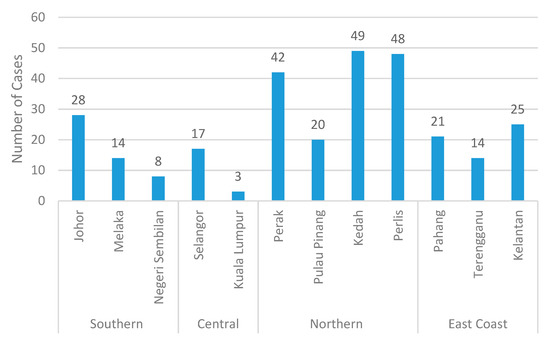
Figure 3.
Windstorm damage cases from 2009 to 2016.
Figure 3 shows that the Northern Region of Peninsular Malaysia experienced the highest windstorm damage during the recorded period with a total of 159 cases followed by the Eastern Region (60 cases), whereas the Central Region had the lowest damage with only 20 cases. The Southern Region registered 50 cases in the three states, with Johor the leading state with 28 cases. The Northern and Central Regions windstorms caused destruction of houses and vehicles, roofs and trees uplifting, power failure, and human casualties, while the Eastern and Southern Regions experienced house and vehicle damaging, lifting of roofs and trees, animal loss, and human injuries. Despite the similarities in the type of damages in the four regions, the Eastern and Southern Regions did not experience any human loss. Most of the recorded damage cases were associated with floods.
It is obvious that the windstorm events were scattered all over Peninsular Malaysia, and the Northern Region was the most affected. The most developed state (Kuala Lumpur), which falls into terrain category 4, experienced the lowest number of windstorms during the recorded period due to its high surface roughness factor. On the contrary, Kedah, Perlis, and Perak were severely struck by windstorms. These states are considered the least developed in Malaysia and are classified as terrain category 1 (flat and open surface). The same observations were reported by Wan chik et al. [8], who found that Kedah suffered more windstorm damage due to the effect of the terrain category and due to being less developed.
It is well-known that in addition to the hazard exposure and vulnerability, damage is a function of the socioeconomic status. In this study, the social vulnerability indicators (demographic features) were taken into consideration. Using the database to investigate the relationship between the windstorm damage cases and the demographic condition (population and area) during 2009–2016, Figure 4 was constructed. According to the results in Figure 4, Kedah, Perlis, and Perak, which had the highest number of windstorms, were less populated than Selangor and smaller than Pahang in terms of area. From a natural point of view, there is a partial relationship between the population, area, and the windstorm damage, as it is expected that more populated areas are more prone to damage. However, the demographic conditions (population and area) may not always be an accurate indication of the windstorm damage. From an economic prospective, the economy of the Northern Region (Kedah, Perlis, and Perak) is weaker compared to that of the Central Region (Selangor and Kuala Lumpur), indicating that the more developed the city, the less severe the windstorm damage.
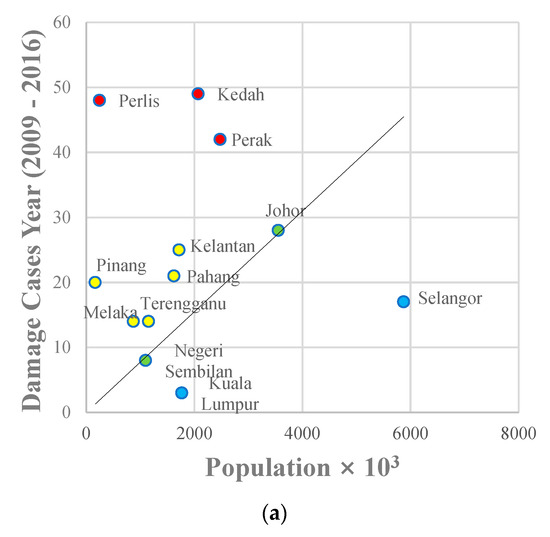
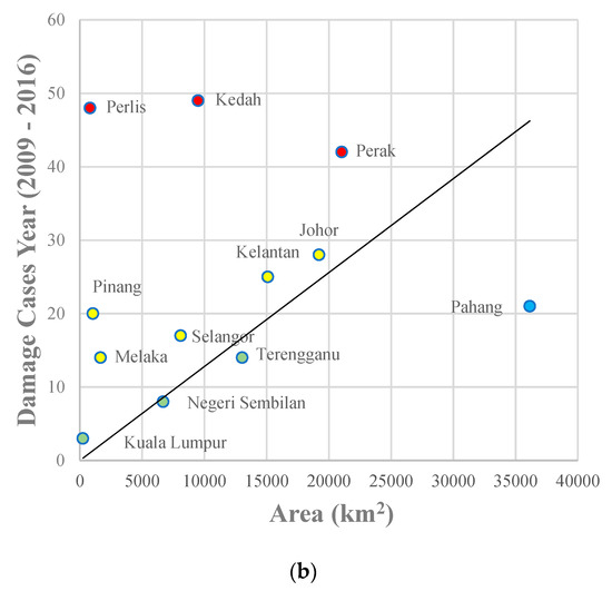
Figure 4.
Relationship between windstorm damage and (a) population; (b) area.
Validation of the Obtained Windstorm Database
Following the same technique of validation as previous researchers [21,22,23], the obtained windstorm database results were validated with the results of Bachok et al. [7], as shown in Figure 5. The results of both studies indicated that the frequency of windstorms (Figure 5a) peaked in both April and September (transition monsoons). The curve behavior of the current study shows a similar trend to that of Bachok et al. [7], even though they are not perfectly matched.
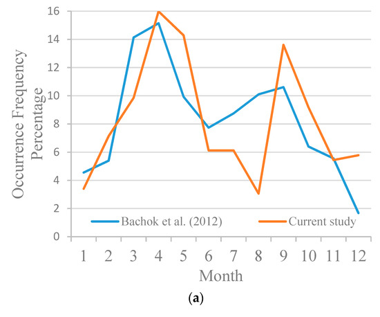
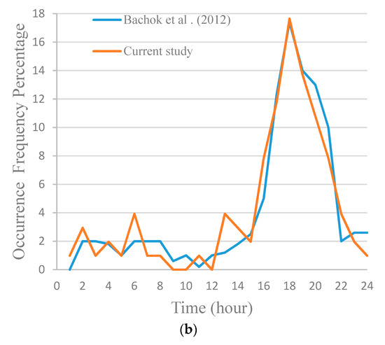
Figure 5.
Validation of the occurrence frequency of windstorm damage cases according to (a) month; (b) hour.
The windstorm occurrence time was also compared, as shown in Figure 5b. The results showed perfect agreement, as the two curves almost overlapped each other, and the peak occurrence time was found to happen between 16:00 to 20:00. Therefore, the data obtained in this study could be employed to develop the wind hazard maps.
3.2. Geodatabase Data Classification
3.2.1. Land Use and Land Cover Data
The terrain category data representing the LULC for the studied locations were based on MS 1553:2002 [10]. However, since the categories in MS 1553:2002 [10] did not match the terrain of these locations, two new categories were introduced to match the Terrain Height Multiplier (Mz,cat ) of these locations based on the study by Wieringa [24] as presented in Table 4. This approach was followed by Lin [25], who developed the Mz,cat coefficient map.
Table 4.
Coefficients and descriptions of the terrain categories.
Figure 6 shows the different land use categories using the Mz,cat coefficients in Table 4 to indicate the surface roughness. It is clearly noticed that a huge part of Peninsular Malaysia fell into categories 4, 5, and 6, signifying that these areas possessed a high surface roughness, which could obstruct the wind movement and lower the produced land use coefficient factors.
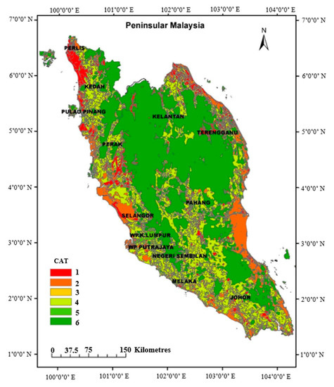
Figure 6.
LULC based on the terrain category.
Figure 7 depicts the developed Mz,cat coefficient map using the spatial interpolation method. The map can be easily used to determine the coefficient factor according to the terrain classification, as well as the wind speed increment or decrement. The map shows that the lowest coefficient factor was found in the interior regions of Peninsular Malaysia, where the terrain category was classified as deep forest area (category 6), while the exterior coastal regions had the highest coefficient factor (category 2) as a result of their low roughness coefficient. Thus, these coastal areas are more vulnerable to windstorms. However, there were some interior regions with high coefficient factors and some coastal areas with low coefficient factors.
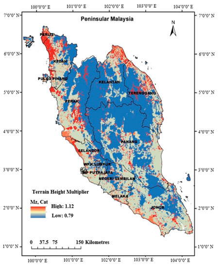
Figure 7.
The Terrain Height Multiplier (Mz,cat) map for Peninsular Malaysia.
By comparing the number of damage cases based on the Mz,cat coefficient, it can be noticed from Table 5 that 81.63% of the windstorms from 2009 to 2016 occurred in terrains with low Mz,cat coefficients (1, 2, and 3) compared to 18.36% in terrains with high Mz,cat (4, 5, and 6). Therefore, it can be generally said that the windstorm occurrence increased with the increase of the terrain category and the decrease of the Mz,cat coefficient. In other words, the roughness of the location played a significant role in the occurrence of windstorms, as Lu et al. [26] and Tan and Fang [27] found in their studies. This also indicates that the population did not contribute as much to the damage severity as the terrain. The highly populated regions experienced less damage than the lesser populated ones. In addition, it is clear that the most developed regions were less affected by the windstorm events during the recorded period.
Table 5.
Damage cases based on LULC category.
It can be seen that the percentage of category 2 (3.11%) was lower than the values of categories 1 and 3 because there were not many residential units within this type of terrain. In addition, the MS 1553:2002 [10] only has four main terrain categories, and it considers categories 1 and 2 mentioned in this study as one category. However, in this study, the four main terrain categories in MS 1553:2002 [10] were reclassified into six categories to help investigate each terrain as a single identity.
3.2.2. Data Hill Shape Multiplier
Ngo and Letchford [28] and Chamanehpour [29] mentioned that the wind speed increases as it passes across a hill or a cliff. Thus, the Hill Shape Multiplier (Mh) was taken into account in the current study. Figure 8 shows the Mh coefficient map constructed by employing the DEM and reclassifying the slope degree of the investigated terrains with respect to their coefficients. Figure 8 depicts the slope degree of the whole Peninsular, in which the slope of the interior areas is higher than the slope of the coastal regions due to the difference in the nature of the terrains. The interior regions are mountainous, while the coastal areas are mostly plain. The Mh coefficient and the distribution of the damage cases are presented in Table 6. It is clear that the occurrence of windstorms is inversely proportional to the slope degree of the terrain. Therefore, having a plainer area subjects the location to a high potential of having frequent windstorms. That is to say, the development of a particular location is a key factor to reduce the damage of windstorm events.
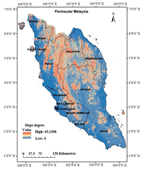
Figure 8.
The slope degree for Peninsular Malaysia.
Table 6.
Damage cases based on the slope conditions.
From Section 3.2, it can be concluded that the terrain conditions and the economic status of these terrains played a very crucial role in the occurrence of the windstorm damage from 2009 to 2016, while the social demographic features (population) was not a significant factor in the occurrence of windstorm damages in Peninsular Malaysia.
3.3. Development of Wind Hazard Map
The wind hazard map was developed by multiplying the basic wind speed (Vs) with the Terrain Height Multiplier (Mz,cat) and the Hill Shape Multiplier (Mh). The Vs map, shown in Figure 9, was constructed using the 50-year return period data in Table 2. The map shows that the Vs was generally higher at the Central and Southern Regions compared to the other regions in the Peninsular. The highest recorded wind speed was 32.5 m/s and the lowest was around 24 m/s.
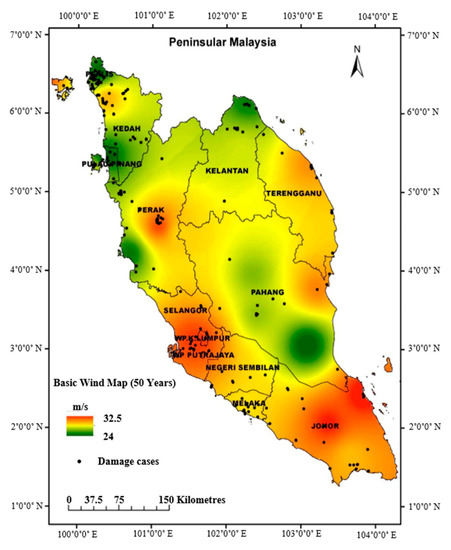
Figure 9.
Basic wind speed (Vs) of Peninsular Malaysia.
Figure 10 depicts the established wind hazard map. By looking at the developed map, locations with a potential high wind speed can be easily identified. For instance, the highest wind speed in the Northern Region was observed in Perak (Lembah Kinta), Kedah, and Perlis, which agreed well with the findings of previous researchers [8,30,31]. For the East Coast Region, both Kuala Terengganu and Marang were found to have the highest wind speed, while Senggarang had the highest wind speed in the Southern Region. However, the map shows no significant distribution of high wind speed in the Central Regions. The highest wind speed throughout the Malaysian Peninsular was around 55.95 m/s, whereas the lowest was approximately 19.3 m/s. In addition, the distribution of damage was more evident at locations with higher wind speeds, as shown by the Vsite wind hazard map (Figure 10).
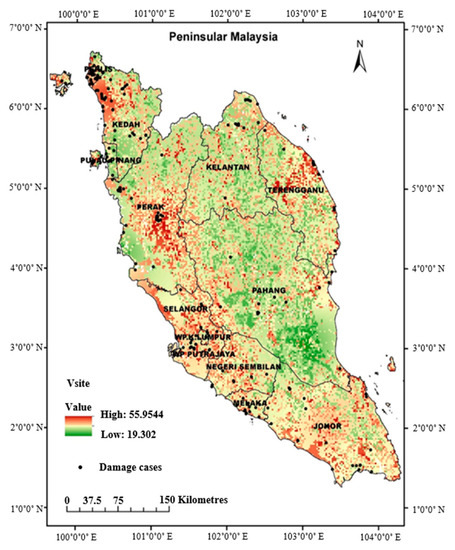
Figure 10.
The Vsite wind hazard map of Peninsular Malaysia.
3.4. Statistical Analysis and Validation
The statistical analysis using the Minitab® statistical software was conducted to evaluate the performance of the developed Vsite wind hazard map for the whole Peninsular Malaysia and for each state.
Four different categories of wind speeds were identified: The basic wind speed (Vs), site wind speed (Vsite), district wind speed (Vdistrict), and subdistrict wind speed (Vmukim). Table 7 presents the comparison between the statistical analysis of the windstorm damage in Peninsular Malaysia. The mean wind speed, median wind speed, and skewers of the Vsite were higher than those of the Vs map. The Vsite reached 38.431 m/s, while the maximum Vs was only 31.599 m/s. The Vsite maximum wind speed was higher by 17.8% compared to that of Vs due to the consideration of the Terrain Height and Hill Shape Multipliers. The windstorm occurrence increased with the increase of the terrain category and the decrease of the Mz,cat coefficient. Moreover, it decreased with the increase of the slope degree. Thus, it can be concluded that the wind hazard map based on Vs predicted a lower potential wind speed compared to the Vsite hazard map. The histogram analysis of the four wind speed categories is depicted in Figure 11.
Table 7.
Statistical analysis of windstorm damage in Peninsular Malaysia.
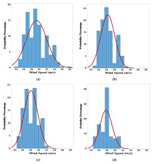
Figure 11.
Histogram analysis of wind speed in Peninsular Malaysia: (a) Vsite; (b) Vmukim; (c) Vs; (d) VDistrict.
Figure 12 shows the CDF of windstorm damage cases based on the 50-year return period adopted by this study. The percentage of the return period was calculated as follows:
where T is equivalent to the number of years. Since T is 50 years, the return period probability is equal to 0.98, which is equivalent to 98%. When projecting this return period probability on the CDF graph, the predicted Vs and Vsite were 31.66 m/s and 34.80 m/s, respectively. The CDF analysis also showed that the probability of intensity of Vsite was higher than that of the Vs. This was attributed to the effects of the Terrain Height and Hill Shape Multipliers on the wind intensity, which were accounted for in the newly developed Vsite map.
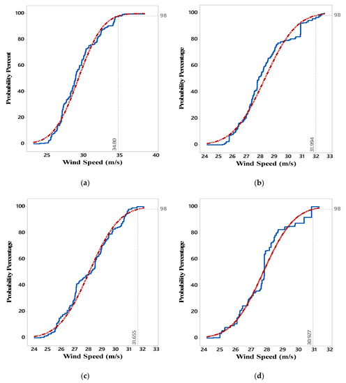
Figure 12.
Cumulative Distribution Function (CDF) analysis of Peninsular Malaysia (a) Vsite; (b) Vmukim; (c) Vs; (d) VDistrict.
The comparison of the 50-year return period wind speeds for all the states of Peninsular Malaysia is presented in Table 8. The results show that the wind speeds based on the Vs map were significantly lower than those of the Vsite map for all states. The difference between the two predicted speeds varied from 3.54% to 17.79%. The highest difference was found in the state of Perlis (17.79%), whereas the lowest was in the state of Kelantan (3.54%). The overall difference in Peninsular Malaysia was around 9%. This clearly indicates that the Vs map underrated the wind hazard at a specific location in Peninsular Malaysia because it did not include the effects of the Terrain Height and Hill Shape Multipliers on the wind characteristics.
Table 8.
The 50-year return period wind speeds of Peninsular Malaysia.
A summary of the statistical analysis of windstorm damage cases for each state in Peninsular Malaysia is presented in Appendix A. When comparing the mean of the Vs and Vsite of each state as illustrated in Figure 13a, the mean of Vsite was higher for all the states except Kuala Lumpur and Selangor. In addition, the comparison of the maximum wind speed of Vsite was also higher except that of Kuala Lumpur (Figure 13b). This could be due to the nature of Kuala Lumpur and Selangor, which are more urbanized. The urban factor introduces a shielding effect to the surroundings, which is defined by MS 1553:2002 [10] as a shielding multiplier. This leads to the conclusion that the hazard map based on the Vs significantly underestimates the actual wind speeds, which results in the underestimation of the potential wind hazards.
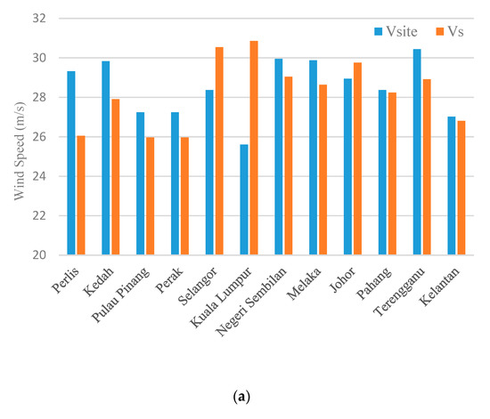
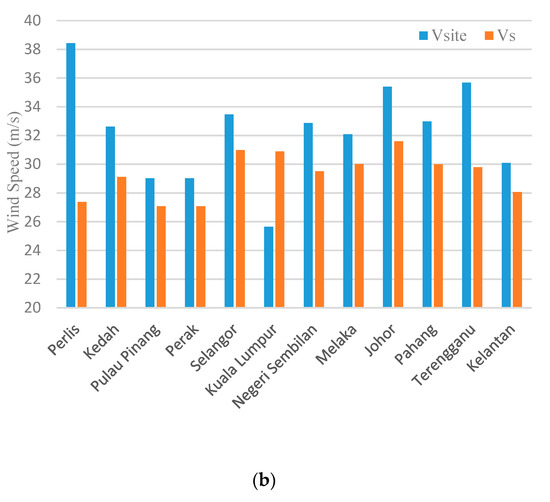
Figure 13.
A comparison between wind speeds (Vs and Vsite): (a) The mean; (b) the maximum.
4. Conclusions
A new wind hazard map for Peninsular Malaysia that considered the effects of LULC and the topographical conditions was constructed to overcome the drawbacks of the existing wind hazard map in the Malaysian Standard. The developed wind hazard map was constructed using the Geographic Information Systems (GIS), and the results were properly compared with the past recorded wind damage cases that occurred in Peninsular Malaysia from 2009 to 2016 in order to validate its accuracy in the evaluation and prediction of potential wind hazards. From the results, the following conclusions can be drawn:
- The Northern Region of Peninsular Malaysia, consisting of five states, was the most affected, and experienced 159 windstorm damage cases, while the Eastern Region of the Peninsular came next with around 60 damage cases. They both suffered human loss beside the destruction of houses and vehicles. The Southern Region (50 cases) and the Central Region (20 cases) experienced similar damage to the previous two regions but did not experience any loss of human life. It was also noticed that the terrain conditions, as well as the economic development, had detrimental effects on the damage occurrence, whereas the population and the area did not contribute greatly to the occurrence of windstorm damage. However, it is not always consistent because the population has been reported as one of the contributors to the windstorm damages in other parts of the world.
- Based on the Terrain Height coefficient, 81.63% of the windstorms from 2009 to 2016 occurred in terrains with low Mz,cat coefficients (1, 2, and 3) compared to 18.36% in terrains with high Mz,cat (4, 5, and 6). Thus, it can be said that the windstorm occurrence increased with the increase of the terrain category and the decrease of the Mz,cat coefficient. In other words, the roughness of the location plays a significant role in the occurrence of windstorms in Peninsular Malaysia. Similar results were reported by Lu et al. [26] and Tan and Fang [27] in their studies.
- The Hill Shape Multiplier (Mh) showed that the occurrence of windstorms is inversely proportional to the slope degree of the terrain. Having a plainer area such as the Northern and Eastern Regions subjected these locations to a higher windstorm damage.
- From the statistical analysis of the windstorm damages, it was found that the mean wind speed, median wind speed, and skewers of the Vsite were higher than those of the Vs by 17.8% because of the Terrain Height and Hill Shape Multipliers. The windstorm occurrence increased with the increase of the terrain category and the decrease of the Mz,cat coefficient. Moreover, it decreased with the increase of the slope degree. Therefore, it can be concluded that the wind hazard map based on Vs predicted a lower potential wind speed compared to the Vsite hazard map.
- The CDF analysis also showed that the probability of intensity of Vsite was higher than that of the Vs by almost 9%. This was due to the effects of the Terrain Height and Hill Shape Multipliers on the wind intensity that were considered in the newly developed Vsite map.
- Overall, the results of the developed Vsite wind hazard map proved that employing the current Vs wind hazard map to assess the windstorm risk is misleading as it underestimates the potential windstorm hazards in Peninsular Malaysia. Thus, it is highly recommended to use the newly developed Vsite map. This newly developed map is a novel contribution to the wind science, especially in tropical countries, where major monsoon periods exist. The map is a clear enhancement of the existing wind map used in Peninsular Malaysia. The authors hope that their developed map will be incorporated into the Malaysian Standard by the relevant authorities to enhance the wind risk assessment.
Author Contributions
The work presented here was carried out through the cooperation of all authors. S.H.A.S., N.I.R., T.A.M. and S.S.Z. conducted the research and wrote the paper. They edited the manuscript including the literature review. All authors have read and agreed to the published version of the manuscript.
Funding
“This research was funded by Universiti Sains Malaysia, grant number (1001/PAWAM/8014023)” and “The APC was funded by Universiti Sains Malaysia”.
Acknowledgments
The authors express their gratitude for the financial support of the Research University Grant from Universiti Sains Malaysia (1001/PAWAM/8014023).
Conflicts of Interest
The authors declare no conflict of interest.
Appendix A
Table A1.
Summary of the statistical analysis of windstorm damage cases for each State in Peninsular Malaysia.
Table A1.
Summary of the statistical analysis of windstorm damage cases for each State in Peninsular Malaysia.
| State | Variable | Windstorm Damage | Mean (m/s) | Standard Deviation | Min (m/s) | Q1 (m/s) | Median (m/s) | Q3 (m/s) | Max (m/s) | Skewness |
|---|---|---|---|---|---|---|---|---|---|---|
| Perlis | Vsite | 48 | 29.315 | 1.832 | 25.178 | 28.748 | 29.089 | 29.769 | 38.431 | 2.210 |
| Vs | 48 | 26.047 | 0.554 | 25.000 | 25.668 | 25.862 | 26.580 | 27.379 | 0.620 | |
| Vmukim | 48 | 28.769 | 1.458 | 25.504 | 27.781 | 28.329 | 29.462 | 32.205 | 0.430 | |
| VDistrict | 48 | 27.838 | 0.000 | 27.838 | 27.838 | 27.838 | 27.838 | 27.838 | - | |
| Kedah | Vsite | 49 | 29.828 | 2.358 | 25.268 | 27.950 | 30.363 | 31.908 | 32.619 | −0.420 |
| Vs | 49 | 27.902 | 1.067 | 25.591 | 27.037 | 28.248 | 28.948 | 29.124 | −0.730 | |
| Vmukim | 49 | 29.243 | 1.989 | 26.442 | 27.548 | 28.484 | 31.450 | 32.621 | 0.530 | |
| VDistrict | 49 | 28.288 | 1.724 | 25.149 | 26.282 | 28.260 | 30.365 | 30.365 | −0.260 | |
| Pulau Pinang | Vsite | 20 | 27.243 | 1.100 | 24.740 | 26.451 | 27.039 | 27.711 | 29.030 | 0.190 |
| Vs | 20 | 25.965 | 0.984 | 24.501 | 24.941 | 26.447 | 26.880 | 27.083 | −0.250 | |
| Vmukim | 20 | 27.899 | 1.633 | 26.263 | 26.459 | 27.486 | 28.755 | 31.334 | 1.140 | |
| VDistrict | 20 | 26.613 | 1.594 | 25.112 | 25.322 | 25.339 | 28.473 | 28.473 | 0.330 | |
| Perak | Vsite | 20 | 27.243 | 1.100 | 24.740 | 26.451 | 27.039 | 27.711 | 29.030 | 0.190 |
| Vs | 20 | 25.965 | 0.984 | 24.501 | 24.941 | 26.447 | 26.880 | 27.083 | −0.250 | |
| Vmukim | 20 | 27.899 | 1.633 | 26.263 | 26.459 | 27.486 | 28.755 | 31.334 | 1.140 | |
| VDistrict | 20 | 26.613 | 1.594 | 25.112 | 25.322 | 25.339 | 28.473 | 28.473 | 0.330 | |
| Selangor | Vsite | 17 | 28.370 | 2.465 | 25.491 | 26.095 | 28.226 | 29.418 | 33.455 | 0.870 |
| Vs | 17 | 30.536 | 0.607 | 28.966 | 30.384 | 30.848 | 30.913 | 30.985 | −1.680 | |
| Vmukim | 17 | 27.983 | 0.883 | 27.109 | 27.109 | 27.871 | 28.423 | 30.078 | 0.800 | |
| VDistrict | 17 | 28.531 | 0.429 | 28.168 | 28.168 | 28.406 | 28.868 | 29.431 | 0.990 | |
| Kuala Lumpur | Vsite | 3 | 25.609 | 0.538 | 24.547 | 25.547 | 25.640 | 25.640 | 25.640 | −1.730 |
| Vs | 3 | 30.854 | 0.648 | 30.780 | 30.780 | 30.892 | 30.892 | 30.892 | −1.730 | |
| Vmukim | 3 | 27.799 | 0.000 | 27.799 | 27.799 | 27.799 | 27.799 | 27.799 | - | |
| VDistrict | 3 | 27.663 | 0.000 | 27.663 | 27.663 | 27.663 | 27.663 | 27.663 | - | |
| Negeri Sembilan | Vsite | 10 | 29.945 | 2.544 | 25.943 | 28.168 | 29.497 | 32.509 | 32.869 | −0.170 |
| Vs | 10 | 29.038 | 0.421 | 28.354 | 28.607 | 29.133 | 29.385 | 29.497 | −0.380 | |
| Vmukim | 10 | 28.137 | 1.739 | 25.285 | 27.406 | 27.896 | 28.551 | 32.319 | 1.300 | |
| VDistrict | 10 | 27.998 | 0.560 | 26.860 | 27.597 | 28.263 | 28.373 | 28.602 | −0.890 | |
| Melaka | Vsite | 15 | 29.875 | 1.989 | 26.138 | 28.512 | 28.541 | 31.967 | 32.087 | −0.160 |
| Vs | 15 | 28.634 | 0.683 | 27.000 | 28.512 | 28.521 | 28.649 | 30.000 | 0.190 | |
| Vmukim | 15 | 28.129 | 0.927 | 26.728 | 27.010 | 28.540 | 29.000 | 29.179 | −0.290 | |
| VDistrict | 15 | 27.974 | 0.559 | 26.500 | 27.835 | 27.920 | 28.010 | 29.000 | −0.500 | |
| Johor | Vsite | 30 | 28.939 | 2.834 | 24.033 | 26.750 | 28.877 | 29.812 | 35.391 | 0.950 |
| Vs | 30 | 29.750 | 0.941 | 28.512 | 29.211 | 29.495 | 29.970 | 31.599 | 0.880 | |
| Vmukim | 30 | 27.879 | 0.848 | 26.392 | 27.337 | 27.831 | 28.567 | 29.131 | −0.210 | |
| VDistrict | 30 | 27.714 | 0.775 | 26.451 | 27.255 | 27.698 | 28.514 | 28.705 | −0.440 | |
| Pahang | Vsite | 21 | 28.363 | 2.399 | 25.229 | 27.001 | 27.142 | 30.050 | 32.982 | 0.770 |
| Vs | 21 | 28.241 | 1.152 | 27.001 | 27.073 | 27.824 | 29.448 | 29.994 | 0.330 | |
| Vmukim | 21 | 27.078 | 0.988 | 25.432 | 26.244 | 27.001 | 28.107 | 28.861 | 0.240 | |
| VDistrict | 21 | 26.010 | 1.034 | 24.592 | 25.022 | 25.683 | 27.126 | 27.531 | 0.280 | |
| Terengganu | Vsite | 14 | 30.443 | 2.529 | 27.326 | 28.789 | 29.350 | 32.513 | 35.676 | 0.670 |
| Vs | 14 | 28.911 | 0.811 | 27.326 | 28.719 | 28.859 | 29.757 | 29.790 | −0.890 | |
| Vmukim | 14 | 29.375 | 2.070 | 25.922 | 28.013 | 29.338 | 31.755 | 31.755 | −0.340 | |
| VDistrict | 14 | 27.656 | 1.471 | 26.399 | 26.399 | 26.899 | 29.812 | 29.812 | 0.840 | |
| Kelantan | Vsite | 25 | 27.013 | 1.149 | 25.533 | 26.351 | 27.109 | 27.196 | 30.079 | 1.210 |
| Vs | 25 | 26.802 | 0.748 | 25.533 | 26.338 | 27.109 | 27.112 | 28.067 | −0.660 | |
| Vmukim | 25 | 26.018 | 0.512 | 25.552 | 25.776 | 25.776 | 26.064 | 27.793 | 2.210 | |
| VDistrict | 25 | 26.363 | 0.508 | 26.096 | 26.096 | 26.096 | 26.276 | 27.659 | 1.980 |
References
- Tamura, Y.; Cao, S. International group for Wind-related disaster risk reduction. J. Wind Eng. Ind. Aerodyn. 2012, 104, 3–11. [Google Scholar] [CrossRef]
- Baker, C. Wind engineering—Past, present and future. J. Wind Eng. Ind. Aerodyn. 2007, 95, 843–870. [Google Scholar] [CrossRef]
- Paton, D. Disaster preparedness: A social-cognitive perspective. Disaster Prev. Manag. Int. J. 2003, 12, 210–216. [Google Scholar] [CrossRef]
- Kubota, T.; Ahmad, S. Wind environment evaluation of neighborhood areas in major towns of Malaysia. J. Asian Archit. Build. Eng. 2006, 5, 199–206. [Google Scholar] [CrossRef]
- Guha-Sapir, D.; Vos, F.; Below, R.; Ponserre, S. Annual Disaster Statistical Review 2010; Centre for Research on the Epidemiology of Disasters, Université catholique de Louvain: Brussels, Belgium, 2011. [Google Scholar]
- Em-dat, C.R. The OFDA/CRED International Disaster Database. Available online: https://ourworldindata.org/ofdacred-international-disaster-data (accessed on 1 January 2020).
- Bachok, M.F.; Shamsudin, S.; Abidin, R.Z. Windstorm Occurrences in Malaysia in the Period of 2000–2012: An Overview. In Proceedings of the 1st ICSTSS International Conference, Kuantan, Malaysia, 1–2 October 2012. [Google Scholar]
- Wan Chik, F.; Che Deraman, S.; Noram, I.R.; Muhammad, M.; Majid, T.; Zulkarnain, N. Development of Windstorm Database System for Wind Damages in Malaysia. J. Civ. Eng. Res. 2014, 4, 214–217. [Google Scholar]
- Majid, T.; Ramli, N.I.; Ali, M.; Saad, M.S.H. In Malaysia Country Report 2012: Wind Related Disaster Risk Reduction and Wind Environmental Issues. In Proceedings of the 7th Workshop on Regional Harmonization of Wind Loading and Wind Environmental Specifications in Asia-Pacific Economies, Vladivostok, Russia, 9–10 September 2012; pp. 12–13. [Google Scholar]
- MS 1553:2002, Malaysia Standard Code of Practise on Wind Loading for Building; Department of Standards Malaysia: Putrajaya, Malaysia, 2002; Available online: https://kupdf.net/download/ms-1553-2002-code-of-practice-on-wind-loading-for-building-structure-tgtp_59eed54e08bbc56f1f9d19fd_pdf (accessed on 1 January 2020).
- Chock, G.Y.; Cochran, L. Modeling of topographic wind speed effects in Hawaii. J. Wind Eng. Ind. Aerodyn. 2005, 93, 623–638. [Google Scholar] [CrossRef]
- Lee, M.-C. Information security risk analysis methods and research trends: AHP and fuzzy comprehensive method. Int. J. Comput. Sci. Inf. Technol. 2014, 6, 29. [Google Scholar]
- Van Westen, C.J. Remote sensing and GIS for natural hazards assessment and disaster risk management. Treatise Geomorphol. 2013, 3, 259–298. [Google Scholar]
- Sundaraj, G. Wind Data Validation and Determination of Basic Wind Speed for Building in Malaysia. Master’s Thesis, Universiti Sains Malaysia, Penang, Malaysia, 2002. [Google Scholar]
- Mornet, A.; Opitz, T.; Luzi, M.; Loisel, S.; Bailleul, B. Wind storm risk management: Sensitivity of return period calculations and spread on the territory. Stoch. Environ. Res. Risk Assess. 2017, 31, 1977–1995. [Google Scholar] [CrossRef]
- Holmes, J.D. Wind Loading of Structures; CRC Press: Boca Raton, FL, USA, 2018. [Google Scholar]
- Albani, A.; Ibrahim, M. Wind energy potential and power law indexes assessment for selected near-coastal sites in Malaysia. Energies 2017, 10, 307. [Google Scholar] [CrossRef]
- Deraman, S.; Wan Chik, F.; Muhammad, M.; Noram, I.R.; Majid, T.; MSS, A. Case Study: Wind speed estimation of high-rise building using surface interpolation methods. J. Civ. Eng. Res. 2014, 4, 145–148. [Google Scholar]
- Ozelkan, E.; Chen, G.; Ustundag, B.B. Spatial estimation of wind speed: A new integrative model using inverse distance weighting and power law. Int. J. Digit. Earth 2016, 9, 733–747. [Google Scholar] [CrossRef]
- Rose, S.; Jaramillo, P.; Small, M.J.; Apt, J. Quantifying the hurricane catastrophe risk to offshore wind power. Risk Anal. 2013, 33, 2126–2141. [Google Scholar] [CrossRef] [PubMed]
- Asare-Kyei, D.; Renaud, F.G.; Kloos, J.; Walz, Y.; Rhyner, J. Development and validation of risk profiles of West African rural communities facing multiple natural hazards. PLoS ONE 2017, 12, e0171921. [Google Scholar] [CrossRef]
- Galli, M.; Ardizzone, F.; Cardinali, M.; Guzzetti, F.; Reichenbach, P. Comparing landslide inventory maps. Geomorphology 2008, 94, 268–289. [Google Scholar] [CrossRef]
- Radhika, S.; Tamura, Y.; Matsui, M. Cyclone damage detection on building structures from pre-and post-satellite images using wavelet based pattern recognition. J. Wind Eng. Ind. Aerodyn. 2015, 136, 23–33. [Google Scholar] [CrossRef]
- Wieringa, J. Updating the Davenport roughness classification. J. Wind Eng. Ind. Aerodyn. 1992, 41, 357–368. [Google Scholar] [CrossRef]
- Lin, X.G.; Nadimpalli, K. Computational Methods for Estimating Wind Local Effects as Part of Wind Risk Assessment. In Proceedings of the 6th Pacific Conference on Wind Eineering, Seoul, Korea, 12–14 September 2005; pp. 2328–2343. [Google Scholar]
- Lu, T.; Guo, J.; Cheng, M.; Li, H.; Yusupujiang, A.; Liu, Y. Model establishment and zoning of wind-dust risk assessment tofeatured forestry and fruit industry in Xinjiang. Trans. Chin. Soc. Agric. Eng. 2016, 32, 169–176. [Google Scholar]
- Tan, C.; Fang, W. Mapping the wind hazard of global tropical cyclones with parametric wind field models by considering the effects of local factors. Int. J. Disaster Risk Sci. 2018, 9, 86–99. [Google Scholar] [CrossRef]
- Ngo, T.T.; Letchford, C.W. Experimental study of topographic effects on gust wind speed. J. Wind Eng. Ind. Aerodyn. 2009, 97, 426–438. [Google Scholar] [CrossRef]
- Chamanehpour, E. Site selection of wind power plant using multi-criteria decision-making methods in GIS: A case study. Comput. Ecol. Softw. 2017, 7, 49. [Google Scholar]
- Ramli, N.I.; Ali, M.I.; TA, M. Wind-related Disasters in Malaysia and Changes in Regulations and Practice. Wind Eng. JAWE 2015, 40, 290–293. [Google Scholar] [CrossRef][Green Version]
- Majid, T.; Zakaria, S.; Wan Chik, F.; Deraman, S.; Muhammad, M. Past windstorm occurrence trend, damage, and losses in Penang, Malaysia. J. Eng. Sci. Technol. 2016, 11, 397–406. [Google Scholar]


© 2020 by the authors. Licensee MDPI, Basel, Switzerland. This article is an open access article distributed under the terms and conditions of the Creative Commons Attribution (CC BY) license (http://creativecommons.org/licenses/by/4.0/).