Article

Integrating Indigenous Knowledge with MCDA in the GIS Environment to Determine Site Potential for Water Harvesting in Wadi Hammad Basin in Jordan

by
Abdel Rahman Al-Shabeeb
1,*,
Ibraheem Hamdan
2,
Hani Al Amoush
2,
Rida Al-Adamat
1 and
A’kif Al-Fugara
3
1
Department of GIS and Remote Sensing, Faculty of Earth and Environmental Sciences, Al al-Bayt University, Mafraq 25113, Jordan
2
Applied Earth and Environmental Sciences Department, Faculty of Earth and Environmental Sciences, Al al-Bayt University, Mafraq 25113, Jordan
3
Department of Surveying Engineering, Faculty of Engineering, Al al-Bayt University, Mafraq 25113, Jordan
*
Author to whom correspondence should be addressed.
Sustainability 2022, 14(21), 14033; https://doi.org/10.3390/su142114033
Submission received: 5 September 2022 / Revised: 5 October 2022 / Accepted: 24 October 2022 / Published: 28 October 2022

Abstract

:
The significance of water harvesting in Wadi Hammad basin lies in the fact that the Jordanian government encourages the cultivation of vegetables, wheat, and barley in the country in an effort to improve food security in Jordan and create job opportunities for young people in the agricultural sector. Water harvesting in this basin will augment the water resources used for plant production and livestock watering by flash floods that involve large quantities of runoff. This study aimed to identify the best locations for water harvesting in the Wadi Hammad basin in Jordan via a Multi-Criterion Decision Analysis (MCDA) and indigenous knowledge. This study focused on consulting with indigenous knowledge where they provided information on the study area for water-collecting sites that have been used for years to provide water. In this study, site selection was based on six criteria that had been determined through a review of related literature (drainage density, rainfall depth, lineament density, soil clay content, geology, and slope). Following MCDA analysis, a water-harvesting suitability map was created. The final water-harvesting map uncovered that a large part of the basin (66.53%) has high to very high potential for water harvesting. The technique of water harvesting was subdued to statistical analysis, sensitivity analysis, and the map removal test. This study demonstrates that the selection of relevant water harvesting locations is a lengthy method that needs consultation with indigenous knowledge and the use of MCDA in the GIS environment. The study results, in general, and the final map, in particular, show the good relationship between the sites defined by the use of MCDA and the site suitability for water harvesting that was specified based on indigenous knowledge. Finally, the results of this study, which integrated indigenous knowledge with MCDA, may be employed to help in effective planning for water resource management to warrant the sustainable development of water in Jordan.

1. Introduction

Water has a critical role to play in the socio-economic development of communities. It is a scarce resource in Jordan, which is classified as a semi-arid region. In fact, Jordan is categorized as one of the four poorest countries in water resources in the World. On average, the Jordanian individual consumes less than 100 m3 of water in the year [1,2], which is much lower than the global individual’s average water consumption rate of approximately 1000 m3/year. The individual low water consumption rate in Jordan is ascribed to the aridity of the country and the high population growth rate due to the high birth rate and flow of refugees into the country (Syrians, Palestinians, and Iraqis) [3]. This forced high pressure on the water resources in Jordan, which are quite limited and cannot keep up with the ever-growing demand for water in the country [4]. The scarcity of fresh water in Jordan is a critical constraint to the growth and development of the country. Because of this, effective harvesting of water, whenever possible, is vital for Jordan to minimize rainwater loss and maximize water storage [5].
Rainwater harvesting is simply collecting, accumulating, and storing rainwater. Harvesting rainwater is commonly practiced to provide water for drinking, irrigation, livestock use, and groundwater recharge. Traditionally, several water-harvesting methods have been applied over centuries. One of the earliest methods in the Middle East was founded on the diversion of wadi (i.e., valley) flows through dry streams to agricultural lands.
Water harvesting is particularly fitting for the arid and semi-arid areas in the world, where the rainfall volume is either inadequate for sustaining good pasture and crop growth or the crop failure risk is very high because of irregular or intermittent precipitation. Water harvesting contributes to increased plant growth and, hence, production in areas subject to drought through the provision of an additional source of water for irrigation via directing the rainfall runoff through carefully selected routes within the target area and concentrating it in certain parts of it to be available in reasonable quantities for human use [6]. In this context, harvesting water has been a common practice throughout history in Jordan for household and irrigation goals.
A Multi-Criteria Decision Analysis (MCDA) was employed in the Geographic Information System (GIS) environment by researchers for the selection of the optimum locations for water harvesting (e.g., Elewa et al. [7], Al-Khuzaie et al. [8], Sayl et al. [9], Srivalli and Singh [10], Adham et al. [11], Al-Adamat et al. [12,13], Al-shabeeb [14], Bakir and Xingnan [15], and Gupta et al. [16]). In most of these studies, the variables used to identify the sites with high potential for water harvesting were rainfall volume, slope, soil texture, site geology, drainage density, and lineament density. The viability of integrating indigenous knowledge with geoinformatics to determine the most suitable sites for water harvesting has been investigated by several researchers, including Elewa et al. [7], Al-shabeeb [14], Al-Adamat et al. [12], Izugbara et al. [17], Oweis et al. [18], Eastman [19], Vorhauer and Hamlett [20], and Gonzalez [21]).
For the analysis of data in an effort to locate the optimum locations for water harvesting, this study followed the approach to data analysis that was used by Elewa et al. [7], Al-shabeeb [14], Smerdon et al. [22], and Gonzalez [21]. All variables under consideration were assigned equal weights and binary coding in which 1 denotes a suitable site for water harvesting and 0 points to a non-suitable site. This approach differs from the approach followed by Shatnawi [23], Al-shabeeb [14], and Al-Adamat et al. [12], who employed the Weighted Linear Combination (WLC) method owing to the fact that weighting is a highly sophisticated process, and it may produce misleading outcomes. Al-Adamat et al. [12] pinpointed that interpreting weights as a general indicator of importance is misleading. The incorrect allocation of weights is a particularly popular error in applying the WLC method to spatial problems [12,14].
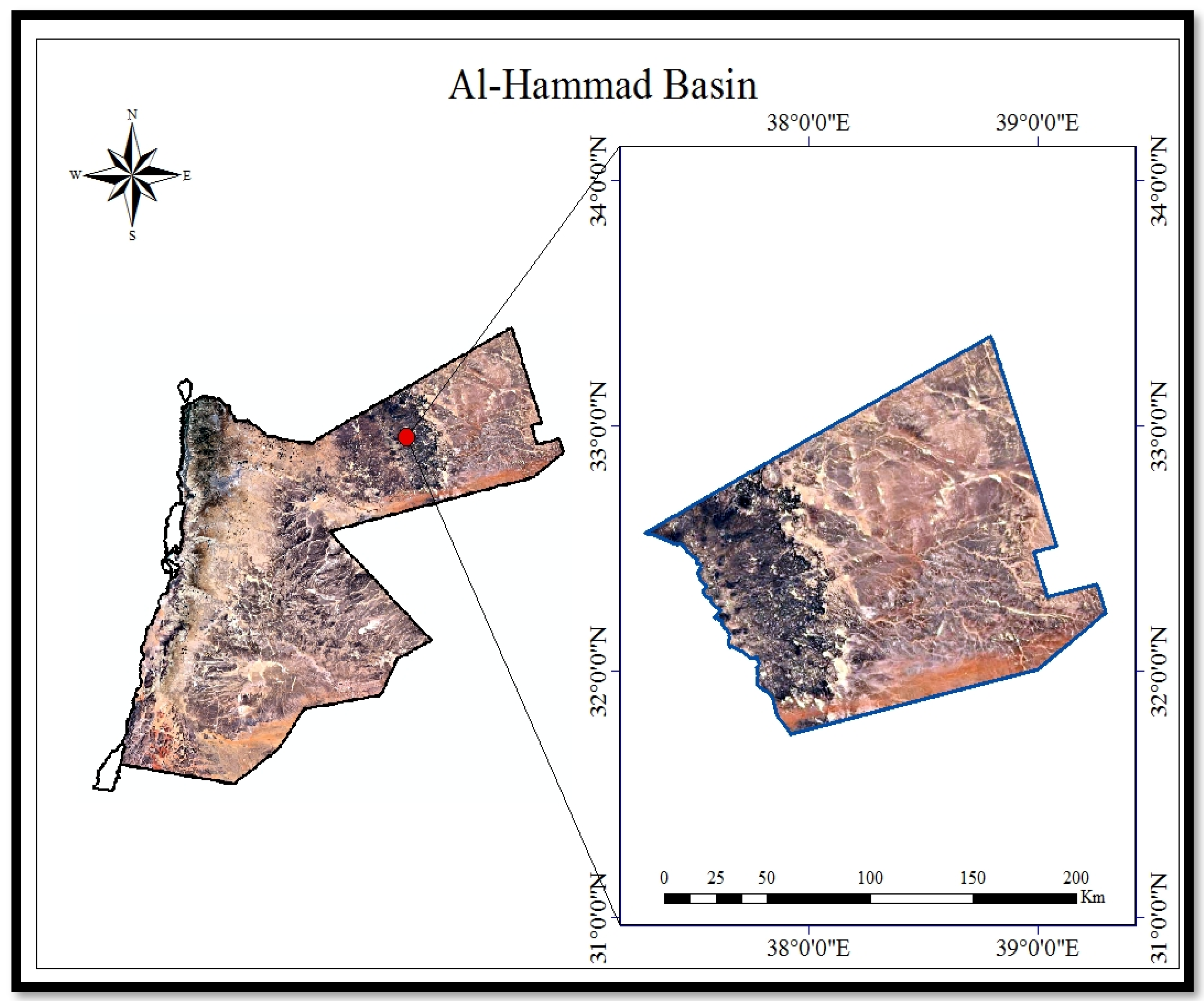
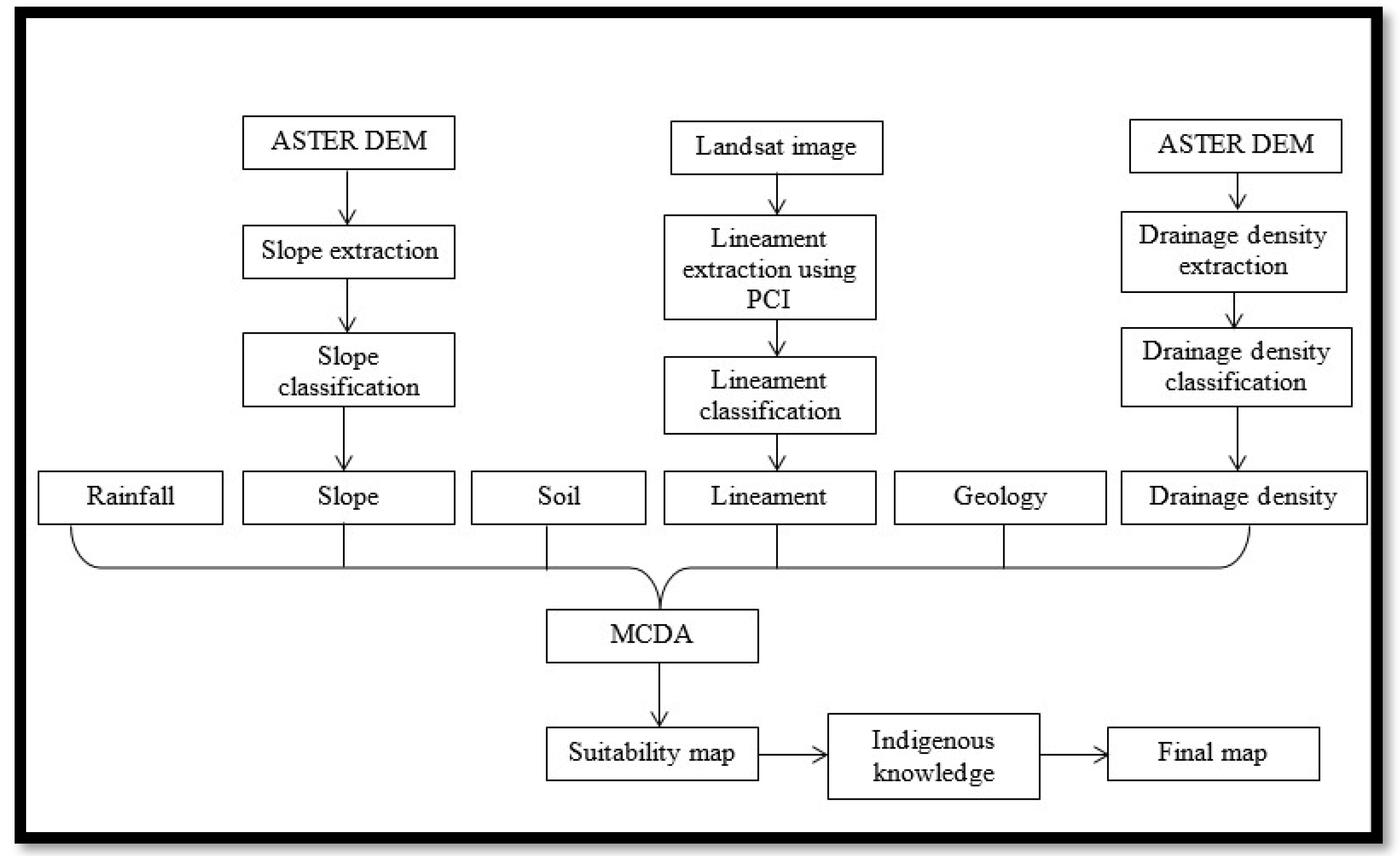
The principal aim of this work was to develop criteria for selecting the best locations for rainwater harvesting in the Wadi Hammad basin in Jordan by incorporating indigenous knowledge with MCDA in the GIS environment. The strategic national plans for investment in the agricultural sector aim to improve the living conditions of citizens and workers in the agricultural sector, increase agricultural production, and increase the use of modern technology to improve water use efficiency. However, investment in the agricultural sector in Jordan suffers from several challenges, which mainly include climate change, the lack of sufficient water resources in Jordan, both groundwater and surface water, and the limited sources of funding to support agricultural organizations and associations. One of the current priorities of the government is investing in the agricultural sector in the Wadi Hammad basin, east of Jordan, to attract investors and investments to this sector and area and provide the necessary facilities for creating job opportunities for local communities and support the national economy.
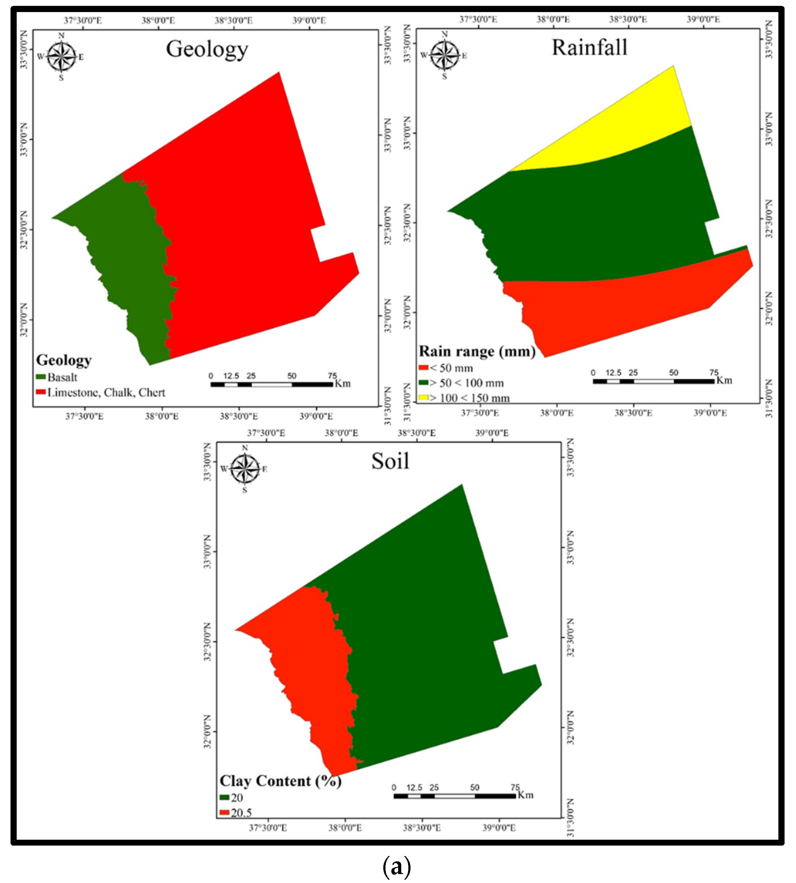
The primary goal of this study was to integrate indigenous knowledge with MCDA in the GIS environment, ultimately to identify potential locations for efficient water harvesting in the Wadi Hammad basin in Jordan, one of the promising basins in Jordan. Despite the scarcity of water in this basin and the very low rainfall amount (it receives 50–150 mm of rainfall in a year), the precipitation regime in this basin is distinguished by intense rainfall of a short duration. This suggests that this basin is a good location for water-harvesting projects.

2. Materials and Methods

2.1. Study Area

The area under study is the Wadi Hammad basin. It lies in the northeast of Jordan (Figure 1) and has an area of nearly 18,012 km2, which constitutes almost 20.7% of the overall area of Jordan. As Figure 1 indicates, this basin extends over the northeast of Jordan and covers parts of the governorate of Mafraq. The size of population inhabiting the study area is more than 15,000 people who live in 6 villages, and their occupations are farmers and livestock pastoralists [24].
Rainfall amount varies in the Wadi Hammad basin from lower than 50 mm/year in the southeastern parts of the basin to 150 mm/year in its northwestern and northeastern parts (Figure 2a). In general, the percentage of clay in the soil of this basin shows extremely low variations; it amounts to 20.0% in its eastern and southeastern parts and 20.5% in the southeast and northeastern parts (Figure 2a).
According to the Ministry of Agriculture, Jordan [25], the thickness of the soil in the Wadi Hammad basin is approximately 20 cm.
The rock formations outcropping in the Wadi Hammad basin are [4,26] (i) the Umm Rijamchert limestone formation (B4), which is made up of chalk, chalky limestone, microcrystalline limestone, and chert layers that range in thickness from 100 m to 200 m; (ii) the Wadi Shallaleh chalk formation (B5), which comprises chalk and chalky marl with thin beds of marly limestone; the thickness of this formation varies broadly in this basin from 40 m to 200 m; and (iii) the basalt formation (BA). This formation consists of dykes, flood lava, and volcanic and pyroclastic cones. The major geological formations in this basin are listed in Table 1.
Groundwater in the Wadi Hammad basin is incubated in three hydro-geological aquifer systems as follows [27]:
  • The upper aquifer system is a basaltic and Wadi Shallaleh aquifer.
  • The middle hydro-geological aquifer system comprises four aquifers:
    -
    Amman Silicified limestone (B2)/Wadi As Sir limestone (A7) aquifer.
    -
    Kurnub sandstone aquifer of lower Cretaceous age.
    -
    Azab limestone aquifer of Jurassic age.
    -
    Ramtha dolomitic aquifer of Triassic age.
  • The lower aquifer system (the so-called Ram aquifer) consists of Disi sandstone.
The B4/B5 aquifer system forms a combined aquifer with an average thickness of approximately 230 m. The areas with prevalent basaltic formations in the Wadi Hammad basin are good and promising for water recharge, where the basaltic aquifer is connected hydraulically to the underlying B4/B5 aquifer. They represent a recharge area for the B4/B5 aquifer.

2.2. Research Methods

Data Collection

This study used six MCDA criteria to determine the best probable sites for water harvesting in the Wadi Hammad basin. The data needed for this study were collected from various sources. The types and sources of the data that were employed in this study are listed in Table 2, including the slope based on a Digital Elevation Model (DEM).

3. Results and Discussion

3.1. Data Analysis

Figure 3 is a flowchart of the method used in the GIS environment to identify the potential water-harvesting sites. The figure clarifies the MCDA data and tools that were employed in mapping the promising water harvesting locations that had been identified by this study.
As shown in Table 3, six maps (soil clay content, rainfall depth, geology, drainage density, lineament density, and slope maps) were integrated to determine potential water-harvesting locations in the Wadi Hammad basin. A brief description of the adopted MCDA criteria and justifications for selecting them out of the set of site selection criteria is given in this table.
Rainfall
Rainfall depth is a highly important parameter that plays a big role in the identification of appropriate locations for water harvesting. Areas with high rainfall rates and depth have a higher potential for water harvesting than areas receiving low rainfall. The rainfall map portrayed in Figure 2a was subdued to manipulation using the ArcGIS software by adding to it the relevant ratings in accordance with Table 3. Then, the map was converted into the raster format and multiplied by the corresponding weight for each considered criterion (Figure 2a). Values in this map varied from 0.245 to 0.49 (Figure 2a).
Slope
For a location to be suitable for water harvesting, it should have a low slope (i.e., a flat location). The slope map for the area under study (Figure 2b) was extracted from ASTER DEM (30 m). The slopes were classified as shown in Table 3 and the values were multiplied by the weights associated with each investigated criterion (Figure 2b). The resultant values varied from 0.202 to 0.808.
Soil Clay Content
Soil clay content has a pronounced impact on the amount of runoff and, thereupon, on rainwater harvesting. The map of soil clay content that is portrayed in Figure 2a was subdued to manipulation using the ArcGIS software by the addition of the relevant ratings in accordance with Table 3. Then, the soil clay content map was converted into the raster format and multiplied by criterion weights (Figure 2a). The resulting soil clay values ranged from 0.30 to 0.45.
Drainage Density
Draining density may indirectly denote the suitability of sites in an area for water harvesting because of the relation between permeability and surface runoff. By using the Flow Direction and Flow Accumulation tools in ArcGIS, the drainage map (Figure 2b) was generated from the ASTER DEM. The Density tool in the ArcGIS software was then employed to compute drainage density, which was afterwards classified in accordance with Table 3. Thereafter, the outcomes of this operation were multiplied by the weights of each of the six considered criteria. The obtained drainage density values had the range of 0.133–0.532 (Figure 2b).
Lineament Density
Further threats to water harvesting are associated with high lineament density values as they reflect a high potential for infiltration of rainwater and runoff to the water table. The Density tool in ArcGIS was employed to compute lineament density values. After that, the values obtained were classified in accordance with Table 3. Thereafter, the outputs of this multiplication were multiplied by the weights of the criteria (Figure 2b). The eventual lineament density values varied from 0.426 to 0.568 (Figure 2b).
Geology map
Geology maps are an important tool that is frequently employed to identify potential locations for water harvesting based on dominant rock types. The geology map given in Figure 2a was subdued to manipulation in ArcGIS by the addition of the suitable ratings as listed in Table 3. Then, the geology map was converted into the raster format and multiplied by the weights of the studied criteria (Figure 2a). Geology map values varied from 0.128 to 0.512.
Multi-Criteria Decision Analysis (MCDA) is a technique that is frequently employed for site selection in the ArcGIS environment. This analysis has been widely used for the identification of potential sites for water harvesting over the past few years. In the current study, the map for site suitability for water harvesting (rainwater and runoff) in the Wadi Hammad basin was created (Figure 4). This map displays the potential sites for water harvesting in this basin. The MCDA helped in determining suitable locations for water harvesting. In the current study, site suitability for water harvesting has been categorized into six classes: Very high suitability, high suitability, moderate suitability, low suitability, very low suitability, and lacking suitability. In this context, Figure 4 indicates the site potential for water harvesting and shows the percentage of the overall area of the basin that is suitable for water harvesting. The results of this study (Figure 4) show that suitable locations for water harvesting are concentrated in sites with gentle slopes and high drainage densities.
Rainfall influenced the suitability of sites for water harvesting the most. The suitability map (Figure 4) unveils that the overall area of the locations that are suitable for water harvesting is 27.03% of the area of the Wadi Hammad basin. Meanwhile, almost 39.50% of the area of this basin pertains to locations that have high suitability for water harvesting Table 4).

3.2. Sensitivity Analysis

3.2.1. Statistical Analysis

A descriptive statistical analysis of the six investigated criteria for site suitability for water harvesting (Table 5) points out that slope and soil clay content contribute the highest to site suitability for water harvesting since they have the highest mean values (0.790 and 0.450, respectively). The remaining four criteria (rainfall, geology, drainage density, and lineament density) have moderate contributions to site suitability for water harvesting in view of their relatively low mean values (0.282, 0.226, 0.153, and 0.021, respectively).
The study results (Table 5) demonstrate that lineament density varies greatly in the study area. It has a CV value of 78.51%. In the meantime, variations in soil clay content in the Wadi Hammad basin are slight whereas variations in drainage density, rainfall, and geology are moderate. The corresponding CV values are 35.47%, 30.85%, and 23.95%, respectively. Meantime, the slope criterion is the variable with the least variability (CV = 8.47%). Sensitivity was computed on the basis of the weight and rating specified for the feature class of each criterion under study.

3.2.2. Map Removal Analysis

Descriptive statistics for the six investigated criteria after the removal of one criterion at a time are summarized in Table 6. The statistics unveil that the determinants of site suitability for water harvesting follow the order of importance of drainage density, geology, rainfall, and lineament density, followed by soil clay content and slope. The highest mean values are associated with drainage density (2.529), geology (2.481), rainfall (2.174), lineament density (2.139), and soil clay content (2.136). On the other hand, slope has the lowest sensitivity value (2.008).

3.2.3. Map Removal Sensitivity Analysis

Lodwick et al. [29] developed the map removal sensitivity analysis concept. This study adopted this concept to determine the sensitivity of each of the six selected site selection criteria in the final water-harvesting map. The sensitivity index (S) was calculated for each criterion using Equation (1), which was developed by Lodwick et al. [29]:
S = |(V/N) − Vxi/n|
where:
  • S: Sensitivity index of the criterion.
  • V: Intrinsic water harvesting index of the method.
  • N: Number of criteria employed in the calculation of V.
  • Vxi: Intrinsic index of the water-harvesting method, which is obtained after the removal of criterion x.
The sensitivity index of the water-harvesting method was computed for every criterion based on Equation (1) and Table 6. The calculation results are provided in Table 7. This table points out that all six criteria have a strong influence on the water-harvesting map.

4. Conclusions and Recommendations

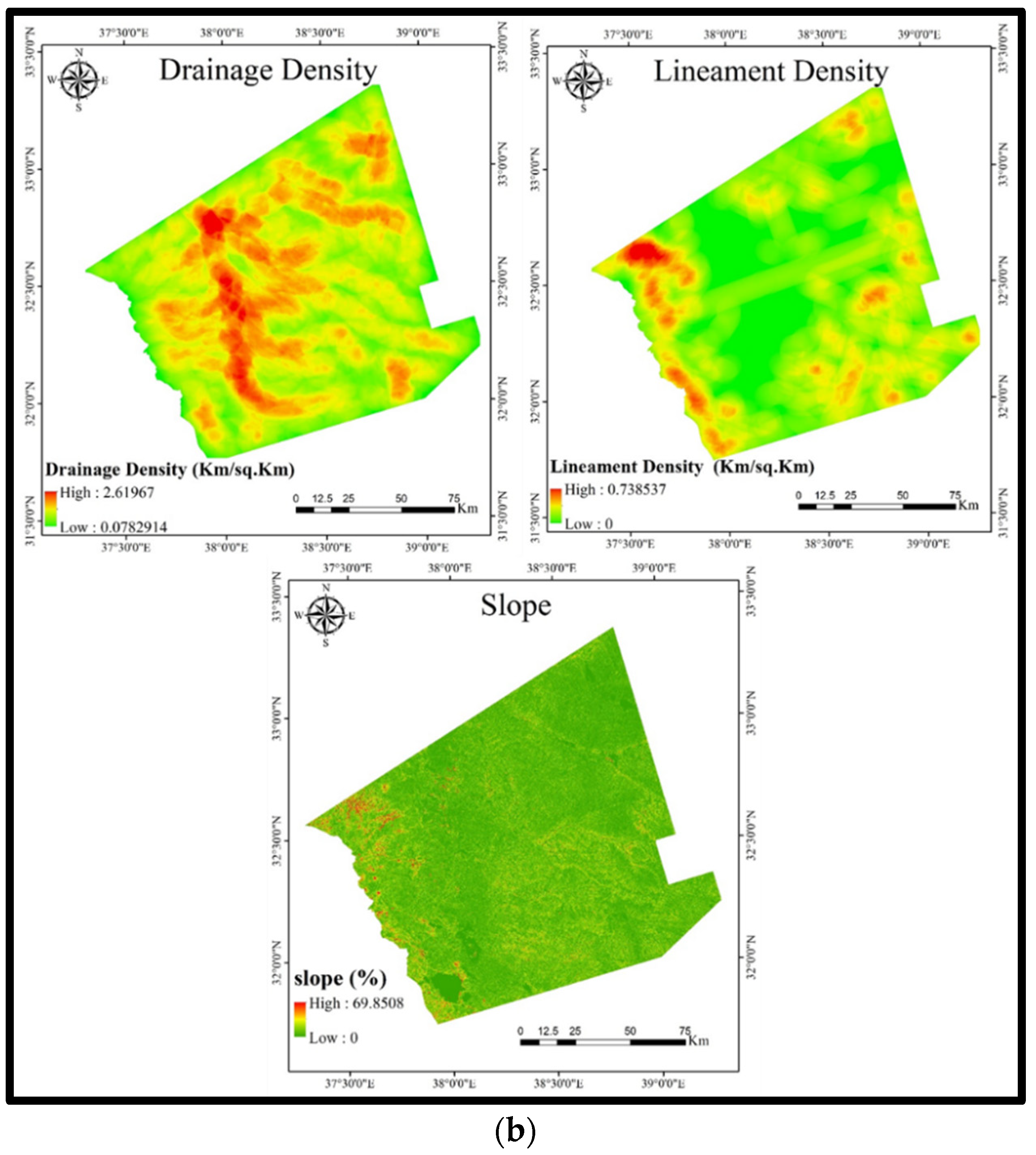
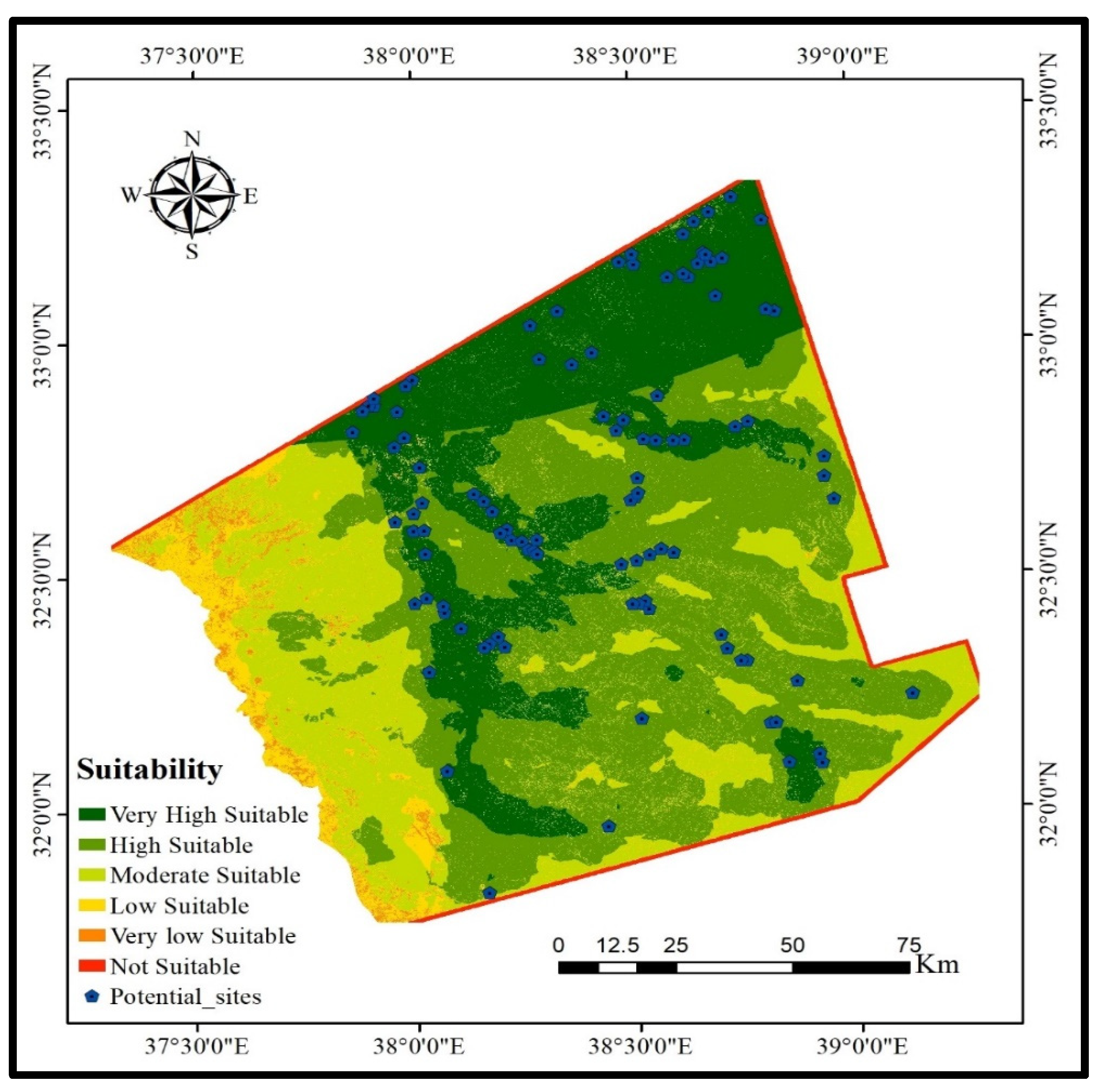
Integrating indigenous knowledge of the local community with MCDA in the GIS environment helps decision makers in making the right decisions. The importance of utilizing local knowledge when selecting the most appropriate sites for water harvesting lies in the fact that this knowledge supports the decision-making process. Local knowledge is based on experience with the nature of the area of interest. Different types of rainwater-harvesting practices—such as Hafirs (small ponds) and pools for water-harvesting techniques—have long been available in the study area as they are traditional methods. This contributes to determining the possibility for it to be exploited for water-harvesting purposes. This study identified potential locations within the study area that can be exploited for water-harvesting purposes based on the knowledge of local people of the area as livestock owners. It verifies the outcomes of the various GIS analyses for determining whether the sites under investigation will be compatible with local knowledge or not. Based on a review of the literature, six criteria were selected to identify the optimal locations for water harvesting in the Wadi Hammad basin (rainfall, soil clay content, slope, lineament density, drainage density, and geology). Then, a Multi-Criterion Decision Analysis (MCDA) was employed to determine the sites within this basin with high potential for water harvesting. The approach of this study was based on integrating all criteria after the multiplication of each with its relative importance rating, specifying the weights of criteria, and unifying the rating for every criterion. The study classified site suitability for water harvesting into six classes: Lacking suitability, very low suitability, low suitability, moderate suitability, high suitability, and very high suitability. More than 40 locations have been found to be highly suitable for water harvesting based on recommendations of the local community and MCDA analysis. In view of the statistical tests performed on the water-harvesting criteria, this study found that lineament density, rainfall, drainage density, soil clay content, geology, and slope have the highest importance in the determination of the best locations for water harvesting. This study contributes to integrating indigenous knowledge with MCDA in the GIS environment to specify the site potential for water harvesting in the Wadi Hammad basin and augment the water resources in the study area if the identified sites are utilized for water harvesting. Doing so will contribute much to sustainable socio-economic development in Jordan. In light of these findings, this study recommends the inclusion of local communities in the specification and selection of the water-harvesting sites. As a matter of fact, the successful selection of suitable sited for water harvesting depends on the relationship between indigenous knowledge and the outcomes of MCDA.

Author Contributions

Conceptualization, A.R.A.-S. and H.A.A.; Investigation, R.A.-A.; Methodology, A.R.A.-S. and R.A.-A.; Project administration, A.A.-F.; Writing—original draft, A.R.A.-S., I.H., H.A.A., R.A.-A. and A.A.-F.; Writing—review & editing, I.H. and A.A.-F. All authors have read and agreed to the published version of the manuscript.

Funding

This research received no external funding.

Institutional Review Board Statement

Not applicable.

Informed Consent Statement

Not applicable.

Data Availability Statement

Not applicable.

Conflicts of Interest

The authors declare no conflict of interest.

References

  1. Khazaa’lah, M.; Talozi, S.; Hamdan, I. Assessment of groundwater vulnerability using GIS-based COP model in the northern governorates of Jordan. Model. Earth Syst. Environ. 2022. [Google Scholar] [CrossRef]
  2. Al-Kharabsheh, A. Challenges to Sustainable Water Management in Jordan. Jordan J. Earth Environ. Sci. 2020, 11, 38–48. [Google Scholar]
  3. Brückner, F.; Bahls, R.; Alqadi, M.; Lindenmaier, F.; Hamdan, I.; Alhiyari, M.; Atieh, A. Causes and consequences of long-term groundwater overabstraction in Jordan. Hydrogeol. J. 2021, 29, 2789–2802. [Google Scholar] [CrossRef]
  4. MWI (Ministry of Water); BGR (Irrigation; Bundesanstalt für Geowissenschaften und Rohstoffe). Groundwater Resource Assessment of Jordan 2017; MWI: Amman, Jordan; BGR: Amman, Jordan, 2019.
  5. Tarawneh, Z.S.; Hadadin, N.A.; Bdour, A.N. Policies to enhance water sector in Jordan. Am. J. Appl. Sci. 2008, 5, 698–704. [Google Scholar] [CrossRef] [Green Version]
  6. Prinz, D.; Pereria, L.; Feddes, R.A.; Gilleym, J.R.; Lessaffre, B. Water Harvesting Past and Future. In Proceedings of the NATO Advanced Research Workshop, Vimeiro, Portugal, 21–26 March 1994; University of Karlsruhe, Institute of Hydraulic Structures and Rural Engineering: Karlsruhe, Germany, 1996; pp. 137–168. [Google Scholar]
  7. Elewa, H.H.; Zelenakova, M.; Nosair, A.M. Integration of the analytical hierarchy process and GIS spatial distribution model to determine the possibility of runoff water harvesting in dry regions: WadiWatir in Sinai as a case study. Water 2021, 13, 804. [Google Scholar] [CrossRef]
  8. Al-Khuzaie, M.M.; Janna, H.; Al-Ansari, N. Assessment model of water harvesting and storage location using GIS and remote sensing in Al-Qadisiyah, Iraq. Arab. J. Geosci. 2020, 13, 1154. [Google Scholar] [CrossRef]
  9. Sayl, K.N.; Mohammed, A.S.; Ahmed, A.D. GIS-based approach for rainwater harvesting site selection. In IOP Conference Series: Materials Science and Engineering; IOP Publishing: Bristol, UK, 2020; Volume 737, p. 012246. [Google Scholar]
  10. Srivalli, C.R.; Singh, M. Identification of potential sites for water harvesting structures in Gadela watershed using remote sensing and GIS. Environ. Conserv. J. 2019, 20, 125–130. [Google Scholar] [CrossRef]
  11. Adham, A.; Sayl, K.N.; Abed, R.; Abdeladhim, M.A.; Wesseling, J.G.; Riksen, M.; Fleskens, L.; Karim, U.; Ritsema, C.J. A GIS-based approach for identifying potential sites for harvesting rainwater in the Western Desert of Iraq. Int. Soil Water Conserv. Res. 2018, 6, 297–304. [Google Scholar] [CrossRef]
  12. Al-Adamat, R.; AlAyyash, S.; Al-Amoush, H.; Al-Meshan, O.; Rawajfih, Z.; Shdeifat, A.; Al-Harahsheh, A.; Al-Farajat, M. The combination of indigenous knowledge and geo-informatics for water harvesting siting in the Jordanian Badia. J. Geogr. Inf. Syst. 2012, 4, 22156. [Google Scholar] [CrossRef] [Green Version]
  13. Al-Adamat, R.; Al-Shabeeb, A.A.R.; Al-Amoush, H. The Use of Vector-Based GIS and Multi-Criteria Decision Making (MCDM) for Siting Water Harvesting Dams in Karak Governorate/South Jordan. J. Nat. Sci. Res 2017, 7, 28–35. [Google Scholar]
  14. Al-shabeeb, A.R. The use of AHP within GIS in selecting potential sites for water harvesting sites in the Azraq Basin—Jordan. J. Geogr. Inf. Syst. 2016, 8, 73–88. [Google Scholar] [CrossRef] [Green Version]
  15. Bakir, M.; Xingnan, Z. GIS and Remote Sensing applications for rain water harvesting in the Syrian Desert (Al-Badia). In Proceedings of the 12th International Water Technology Conference, Alexandria, Egypt, 27–30 March 2008; pp. 73–82. [Google Scholar]
  16. Gupta, K.K.; Deelstra, J.; Sharma, K.D. Estimation of water harvesting potential for a semi-arid area using GIS and remote sensing. IAHS Publ.-Ser. Proc. Rep.-Intern Assoc Hydrol. Sci. 1997, 242, 63. [Google Scholar]
  17. Izugbara, C.O.; Ugal, G.A.; Ukwayi, J.K. Indigenous knowledge and communal conflict resolution: Evidence from Nigeria. Indilinga Afr. J. Indig. Knowl. Syst. 2003, 2, 1–14. [Google Scholar] [CrossRef]
  18. Oweis, T.; Prinz, D.; Hachum, A. Water Harvesting: Indigenous Knowledge for the Future of the Drier Environments; ICARDA: Beirut, Lebanon, 2001. [Google Scholar]
  19. Eastman, J.R. Idrisi for Windows, User’s Guide, Version 2.0, Clark Labs for Cartographic Technology and Geographic Analysis; Clark University: Worcester, MA, USA, 1997. [Google Scholar]
  20. Vorhauer, C.F.; Hamlett, J.M. GIS: A tool for siting farm ponds. J. Soil Water Conserv. 1996, 51, 434–438. [Google Scholar]
  21. Gonzalez, R. KBS, GIS and documenting indigenous knowledge. Indig. Knowl. Dev. Monit. 1995, 3, 5–7. [Google Scholar]
  22. Smerdon, B.D.; Allen, D.M.; Grasby, S.E.; Berg, M.A. An approach for predicting groundwater recharge in mountainous watersheds. J. Hydrol. 2009, 365, 156–172. [Google Scholar] [CrossRef]
  23. Shatnawi, G. Determine the Best Sites for Water Harvesting Projects (Dams &Hafirs) in Northeastern Badia Using GIS Applications. Master’s Thesis, Al Al-Bayt University, Mafraq, Jordan, 2006, unpublished. [Google Scholar]
  24. DOS (Department of Statistics). Jordan Statistical Yearbook 2021; Department of Statistics: Amman, Jordan, 2021.
  25. MoA (Ministry of Agriculture). National Soil Map and Land Use Project. The Soil of Jordan, Level 2: Semi Detailed Studies; Ministry of Agriculture: Amman, Jordan, 1994.
  26. WAJ (Water Authority of Jordan). Groundwater Investigations in the Hamad and Sarhan Bsain; Internal Report; Ministry of Water and Irrigation, Water Authority: Amman, Jordan, 1995; Volume 1.
  27. Obeidat, M. Hydrochemistry and Isotope Hydrology of Groundwater Resources in the Hammad Basin, Jordan. Ph.D. Thesis, Wurzberg Unuiversity, Würzburg, Germany, 2000; 168p. unpublished. [Google Scholar]
  28. USGS. ASTER Digital Elevation Model (DEM) 30 m Resolution. 2022. Available online: https://earthexplorer.usgs.gov (accessed on 31 March 2022).
  29. Lodwick, W.A.; Monson, W.; Svoboda, L. Attribute error and sensitivity analysis of map operations in geographical informations systems: Suitability analysis. Int. J. Geogr. Inf. Syst. 1990, 4, 413–428. [Google Scholar] [CrossRef]
Figure 1. Location of Wadi Hammad basin.
Sustainability 14 14033 g001
Figure 2. (a): The physical characteristics of the study area (soil, rainfall, and geology). (b): The physical characteristics of the study area (drainage density, lineament density, and slope).
Sustainability 14 14033 g002aSustainability 14 14033 g002b
Figure 3. Flowchart of the method employed in this study.
Sustainability 14 14033 g003
Figure 4. Final map for site suitability for water harvesting in Wadi Hammad basin.
Sustainability 14 14033 g004
Table 1. The major geological formations in Wadi Hammad basin.
GroupFormationRock TypeAge
Volcanic Rocks of Safawi GroupSalman Flood BasaltBasaltic Lithofacies(9.3–8.45) Ma
Abed Olivine Phyric basalt
Ali Doleritic Basalt
Quaternary SedimentsPleistocene Gravel, Mud, flat Aeolian SandGravel, SandPleistocene-Holocene
Balqa GroupWadiShallaleh ChalkLimestone, nummulitic limestone, chalk limestone, discontinuous chert, chert concretionMiddle Eocene
Umm RijamChert, LimestoneThe concretion of limestone, chert, limestone, chalkEocene
Table 2. Types and sources of the secondary data used in this study.
GIS LayerScaleSource
Rainfall1:250,000Higher Council for Science and Technology (digital data)
Drainage (Wadi)1:250,000Royal Jordanian Geographic Centre (digital data)
Geology1:250,000
Fault1:250,000
Soil 1:750,000Jordan Ministry of Agriculture [25]
Slope based on ASTER DEM30 mUnited States Geological Survey [28]
Table 3. Weights and ratings of the six site selection criteria employed in this study.
CriterionWeightSpecificationRating
Rainfall (R)0.245R ≥ 5004
500 > R ≥ 3003
300 > R ≥ 1002
R < 1001
Slope (S)0.202S < 34
5 > S ≥ 33
10 > S ≥ 52
S > 101
Soil clay content (C)0.15C ≥ 35%4
35% > C ≥ 18%3
18% > C ≥ 10%2
C < 31
Drainage density (D)(km/sq. km)0.133D > 2.554
2.55 > D ≥ 1.53
1.5 > D ≥ 0.752
D < 0.751
Lineament density (L)0.1420 < L ≤ 1.54
1.5 < L ≤ 2.53
2.5 < L ≤ 3.52
L > 3.51
Geology (G)0.128Chalky marl, marl, and limestone4
Limestone and dolomitic limestone3
Limestone, chalk, and chert2
Basalt 1
Table 4. Calculated areas of potential locations for water harvesting according to suitability.
ClassArea (km2)% of the Total Area
Lacking Suitability441.712.45
Very Low Suitability264.141.47
Low Suitability968.885.38
Moderate Suitability4354.4324.17
High Suitability7114.9939.50
Very High Suitability4868.6927.03
Total18,012.83100
Table 5. Descriptive statistics of the studied criteria for site suitability for water harvesting.
RainfallSlopeSoil Clay ContentDrainage DensityLineament DensityGeology
Min0.2450.2020.4500.0100.0000.128
Max0.4900.8080.4500.3480.1050.256
Mean0.2820.7900.4500.1530.0210.226
SD0.0870.0670.0000.0540.0160.054
CV (%)30.8518.4720.00035.47478.50623.954
Table 6. Partial index values.
Parameter RemovedMeanMinMaxSD
Slope2.0081.3702.4500.146
Drainage2.5291.4392.7260.131
Geology2.4811.3942.8880.161
Lineament2.1390.9542.5760.184
Rainfall2.1741.2222.5250.148
Soil2.1361.2762.5210.161
Table 7. Sensitivity index values according to map removal sensitivity analysis of the water harvesting map.
Sensitivity Index
ParameterS MinimumS AverageS MaximumStandard Deviation (SD)
Soil0.00020.01530.47760.0634
Geology0.00050.07550.51060.0639
Rainfall0.00080.02190.45120.0621
Slope0.00150.03720.41430.0547
Lineament0.00140.02370.44820.0603
Drainage0.00020.08510.52270.0666
Publisher’s Note: MDPI stays neutral with regard to jurisdictional claims in published maps and institutional affiliations.

