Article

Integrated Wastewater Management for the Protection of Vulnerable Water Resources in the North of Jordan

1
Office of the National Implementation Committee for Effective Integrated Wastewater Management in Jordan (NICE), Ministry of Water and Irrigation, Salem Al Hindawi St. 45, Amman 11183, Jordan
2
Helmholtz-Centre for Environmental Research–UFZ, Permoserstarße 15, 04318 Leipzig, Germany
3
Ministry of Water and Irrigation, Salem Al Hindawi St. 45, Amman 11183, Jordan
*
Author to whom correspondence should be addressed.
Sustainability 2022, 14(6), 3574; https://doi.org/10.3390/su14063574
Submission received: 21 February 2022 / Revised: 14 March 2022 / Accepted: 16 March 2022 / Published: 18 March 2022

Abstract

:
The protection of vulnerable groundwater resources and their optimal management is essential for the Hashemite Kingdom of Jordan to meet current and future water demands. Our overall objective was to analyse the water situation in the district of Bani Kinana, which has received a large number of Syrian refugees in the past, resulting in an increased water demand, which in turn leads to local water shortages and puts tremendous pressure on local groundwater resources. An integrated wastewater resources management (IWRM) approach to protect groundwater resources and to reduce the risk to local communities and ecosystems was developed, and the most cost-effective wastewater treatment system solution was identified, based on the ALLOWS tool (Assessment-of-Local-Lowest-Cost-Wastewater-Solutions). The results show that a large volume of drinking water is directed to the Jordan Valley and it is recommended that this water should be retained to meet current needs and the projected future demand of 8.3 MC in 2050. The ALLOWS tool revealed that the current practice of wastewater disposal by tanker is the costliest scenario in the long-term and will cause the pollution of groundwater resources. A tailored solution, such as the implementation of a cost-efficient semi-centralized wastewater treatment plant, would contribute significantly to protecting vulnerable water recourses.

1. Introduction

Ongoing climate change is affecting the availability, quality and quantity of water for basic human needs and is therefore threatening, worldwide, the human rights of billions of people to have access to water and sanitation [1]. Many regions in the world are already under severe pressure and climate-induced hydrological changes will add challenges to the sustainable management of water resources. Adaption and mitigation of climate change through the use of efficient, sustainable water management is therefore essential to achieving the 2030 Agenda for Sustainable Development [1].
Jordan was one of the first countries in the world to take action aimed at achieving the Sustainable Development Goals (SDG). One of the goals, Goal 6, is to “Ensure availability and sustainable management of water and sanitation for all”, including eight targets such as “to improve water quality by reducing pollution”; “halving the proportion of untreated wastewater and substantially increasing recycling and safe reuse globally” and “to implement integrated water resources management at all levels” [2].
In arid and semi-arid regions, in particular, efficient water management has become an existential challenge, which is further exacerbated by dynamic population development. Jordan is one of the most water scarce countries in the world, where groundwater resources are indispensable for providing sufficient drinking water. The application of integrated wastewater resources management (IWRM) concepts would certainly help to mitigate extreme water scarcity and protect groundwater resources in Jordan. The mitigation of water scarcity in Jordan has been exacerbated by the accommodation of around 1.3 million Syrian refugees since the year 2011, of which the majority might stay in Jordan [3]. However, even long before the accommodation of refugees, the overall situation in the water sector was already stressed. The accommodation of refugees during past decades from Palestine, Lebanon and Iraq, as well as droughts, trans-boundary disputes, water mismanagement and an inefficient agricultural sector, have been identified as the main concerns affecting the water sector [4].
Today, the effects on the water resources in Jordan are clearer than ever before. In particular, the Northern Governorates of Jordan have accommodated a great number of Syrian refugees, which has significantly increased the water demand. This has resulted in local water shortages and, in addition, placed huge pressure on existing sewer networks and wastewater treatment plants, which were not designed for this vast population increase. Existing water infrastructure requires urgent capacity expansion in addition to the current need for repairs, maintenance and technical upgrades in order to prevent, for example, further contamination of groundwater resources with untreated wastewater. As a direct result of accommodating Syrian refugees, the water demand in some northern districts has already increased by about 40% and in some locations the frequency of water supply has decreased to once every four weeks [3].
Groundwater is the main source of drinking water in Jordan. It is often considered a public good which should be available abundantly without charge; therefore, water theft and the protection of groundwater resources are key issues addressed by the Jordanian Ministry of Water and Irrigation (MWI) [5,6] since already more than 50% of groundwater resources are considered unsustainable [7]. Furthermore, the infiltration of untreated wastewater into old infrastructure has further threatened Jordan’s scarce groundwater resources [3]. The protection of water resources of an appropriate quality is of utmost national importance. The optimal management and use of water resources is essential to cover future demand. Groundwater and surface water resources need to be protected in order to restrict pollutants affecting these resources. The majority of water resources in Jordan are already contaminated with coliform bacteria, originating from leaking infrastructure or the inappropriate handling of wastewater. In addition to improving public health and reducing environmental contamination, IWRM is most valuable when it promotes the protection of groundwater resources [8]. Priority should be given to locations where IWRM prevents risks or supports the protection of groundwater from pollution by untreated wastewater [8].
In order to decide where wastewater treatment plants would have a major impact in the protection of groundwater resources, vulnerable water resources, so called ‘hot spots’, have been identified in Jordan [6,9]. These ‘hot spots’ are locations where groundwater has been contaminated or is expected to be contaminated from untreated wastewater through means of leakage from, for example, septic tanks, cesspools, or sewage networks or the inappropriate handling of wastewater. The Harima and Kufr Assad wells/wellfield, both serving as the main drinking water supplies to the district of Bani Kinana in northern Jordan, were identified as one of these ‘hot spots’ [6].
In order to secure the water supply and the treatment of wastewater for the future, the MWI is currently planning and implementing various large and expensive studies, especially in the Northern Governorates. The focus of the government lies mainly in connecting population-dense urban areas to centralized wastewater treatment systems. Rural areas, however, have hardly been considered so far. By applying an integrated approach, various technical, health, economic, environmental and social requirements are considered during the planning and implementation of sustainable wastewater treatment systems. One feasibility study commissioned by the MWI from the year 2019 focused on the district of Bani Kinana [10]. Within this study, some preliminary, simple scenarios were developed, aiming to extend and modernize the drinking water network and to implement a sewage network and wastewater treatment systems with total estimated investment costs at 71–124 million USD. As the costs are high and the population density in Bani Kinana is considerably lower than in urban areas such as Irbid and Ramtha, the project was not given priority by the MWI. However, it is clear that if the population increases by approximately 2.1% per year and if the current water management approach continues, many aquifers and wells will soon be lost.
It is urgent that traditional decision planning pathways are abandoned and, instead, locally adapted IWRM concepts for the protection of vulnerable water resources are implemented, which will also assist in mitigating water scarcity in this particular region. As suggested in the National Framework for Decentralized Wastewater Management and the Policy for Decentralized Wastewater Management in Jordan [8,9], it is recommended that the decision-support tool ALLOWS (‘Assessment of Local Lowest-Cost Wastewater Solutions’) be used for the development of all wastewater management solutions in Jordan in order to assess whether a centralized or decentralized approach is the most feasible at a specific location. Centralized wastewater treatment systems are often inflexible but provide the most cost-efficient solution in urban areas; however, rural areas with a lower population can be provided with cost-efficient semi-/decentralized systems that collect, treat and reuse/dispose the wastewater at or close to its point of generation, as suggested by Crites, et al. [11]. ALLOWS is a GIS-based tool that enables stakeholders and decision-makers to develop different wastewater management scenarios and carry out a cost assessment of each scenario based on a dynamic cost-comparison method. This makes the ALLOWS tool a valuable decision support instrument when selecting the most suitable wastewater management solution for any given local wastewater management problem [12].
The overall objective is to analyze the situation with respect to water resources, as well as the development of an IWRM approach in the district of Bani Kinana (Irbid Governorate; Jordan) to protect vulnerable water resources and to promote sustainable groundwater abstraction and the conservation of groundwater resources to reduce the level of risk to local communities and ecosystems. Furthermore, the most cost-efficient wastewater treatment system solution is identified.

2. Materials and Methods

The methodological approach entailed four components.
First, the water demand and wastewater generation up to the year 2050 were calculated, based on population data.
Second, existing wastewater and water infrastructures were evaluated, vulnerable water resources were identified and described and the potential contamination risk of the vulnerable water resources was identified.
Third, the water balance was determined for the district of Bani Kinana.
Fourth, an integrated wastewater management approach for the protection of the Harima wellfield is presented.

2.1. Risk Assessment

Hydrological analysis was performed to extract contour lines and to calculate the flow accumulation in the study area using the ArcGIS spatial analysis package (Version 10.8 ESRI, Redlands, CA, USA). The analysis includes the following steps: flow direction, flow accumulation and wadi network delineation.
Groundwater vulnerability maps can provide a tool for stakeholders and decision-makers, by showing how fast potential contamination/pollution can reach the groundwater. The groundwater vulnerability of the district of Bani Kinana, Irbid Governorate was described using the COP-Index with the parameters C: concentration of flow; O: Overlying layer and P: precipitation [6,13]. The vulnerability level was categorized as follows: very low, low, moderate, high and very high, according to Breulmann et al. [6]. The potential hazard risk of the drinking water resources, Mukheiba, Kufr Asad, Tubqbul, Qwailbah and Harima in the district of Bani Kinana was based on the number of users within the water catchment of the well and their potential wastewater generation. Based on the population data, 8.2 persons per building in the catchment area were considered.
All wastewater is stored in septic tanks, which are generally not sealed properly. Therefore, it was assumed that most of the liquid fraction (95%) permeates into the soil. The hazard risk was calculated as follows as described by Clemens, et al. [14].

2.2. Scenario Definition

Within this study, three scenarios have been defined for the catchment area of the Harima wells/wellfield in order to achieve the highest degree of wastewater treatment, while keeping the associated costs as low as possible.
Tanker scenario (S1): All buildings collect their wastewater in cesspits which are emptied by tanker trucks that carry the wastewater to the closest centralized wastewater treatment plant. It has been shown by Abdulla, et al. [15] that this wastewater has already degraded to some extent compared to raw wastewater and can cause processing difficulties in centralized wastewater treatment plants. It is worth mentioning that the existing septic tanks need to be sealed or replaced with watertight tanks. The average size of the septic tanks is about 8–15 m3 [12].
Building (on-site) scenario (S2): All buildings are provided with a wastewater treatment system on-site.
Semi-centralized scenario (S3): All buildings are connected to one sewer network and the wastewater is treated locally in the catchment area at one wastewater treatment plant.
The scenarios were analyzed using the ALLOWS (Assessment of Local Lowest Cost Wastewater Solutions) decision support tool [8,12]. By using a combination of spatial and economic analyses, costs were calculated in order to identify the most cost-effective solution.

2.3. Technology Selection

According to the Decentralized Wastewater Management Policy [8] and the data availability regarding investment, re-investment and operation and maintenance costs of the technology, a Sequencing Batch Reactor (SBR) was selected for S2 and S3.

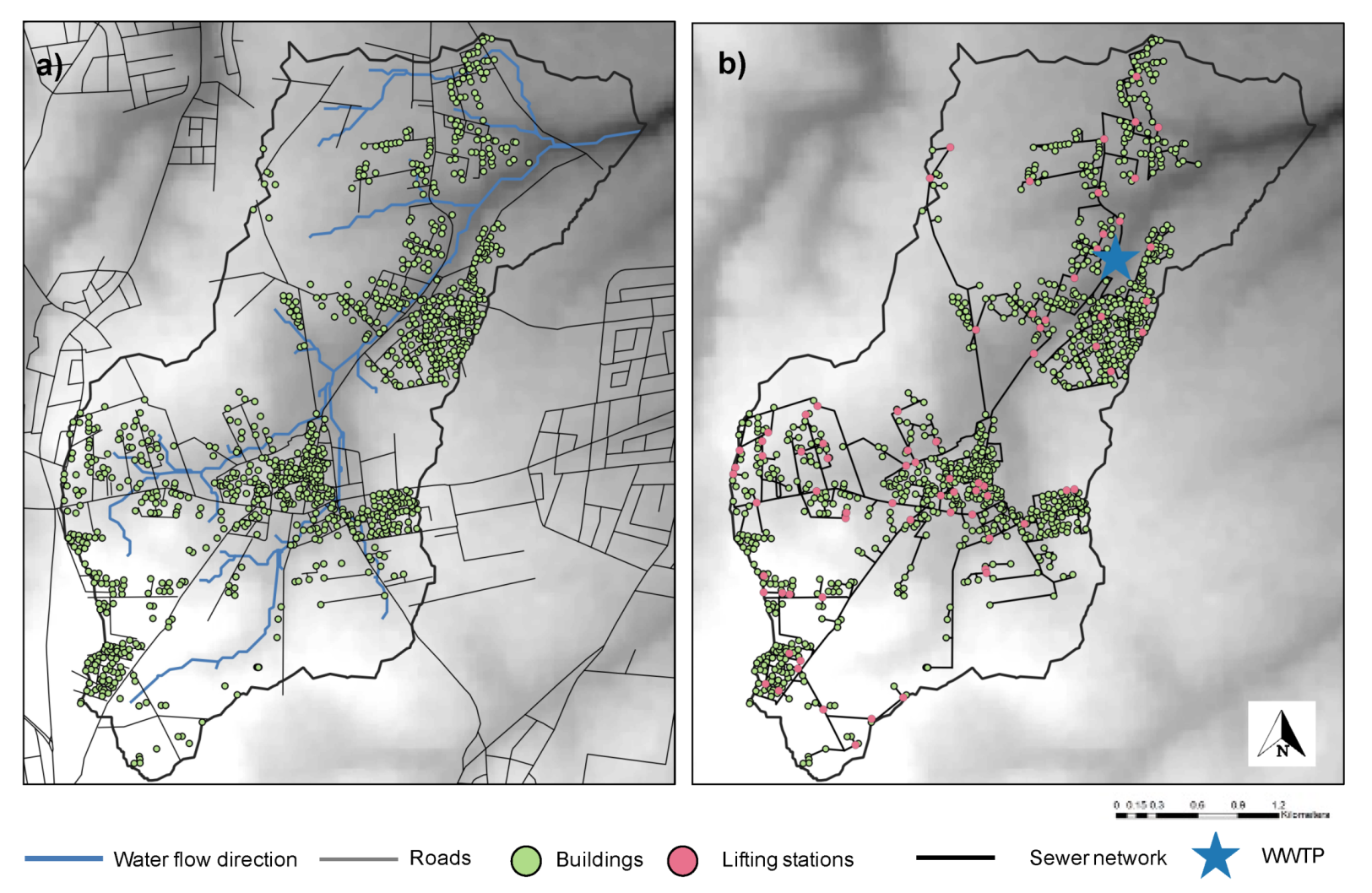
2.4. Building Data and Density

Existing infrastructure data, such as buildings and roads, were input into ArcGIS and compared with satellite data (Google Inc., Mountainview, CA, USA, Digital Globe Image 2021) and if necessary, were manually updated.

2.5. Sewer Design

The sewer network design is based on a Digital Elevation Model (30 × 30 m). In order to realize the maximum wastewater flow by gravity with minimum pumping requirements, the natural topography and existing roads were used to design the sewer network. Elevation profiles were extracted along the street network to identify segments that are not viable for gravity-based flow and hence require additional pumping. These network segments were avoided by using a weighting factor in order to minimize pumping costs and maximize gravitational flow within the sewer network. A network-generation algorithm was then used to derive a sewer network by iteratively combining repeated shortest path calculations in relation to the preprocessed street network until all households could be connected to a wastewater treatment plant. Technical specifications of the sewer network were defined according to a German standard [16,17].
In order to analyze the potential for decentralization, the overall network costs were compared between different degrees of decentralization. The degree of decentralization was defined by calculating a Kernel Density Estimation (KDE) for all buildings within the model domain and classifying buildings as either centrally connected to the treatment plant or served by a decentralized household treatment solution. This classification is based on the spatial intersect of the KDEs percentile extent and the location of the households. Following the previously described method for network generation, networks and associated costs were calculated for the entire range of levels of decentralization.

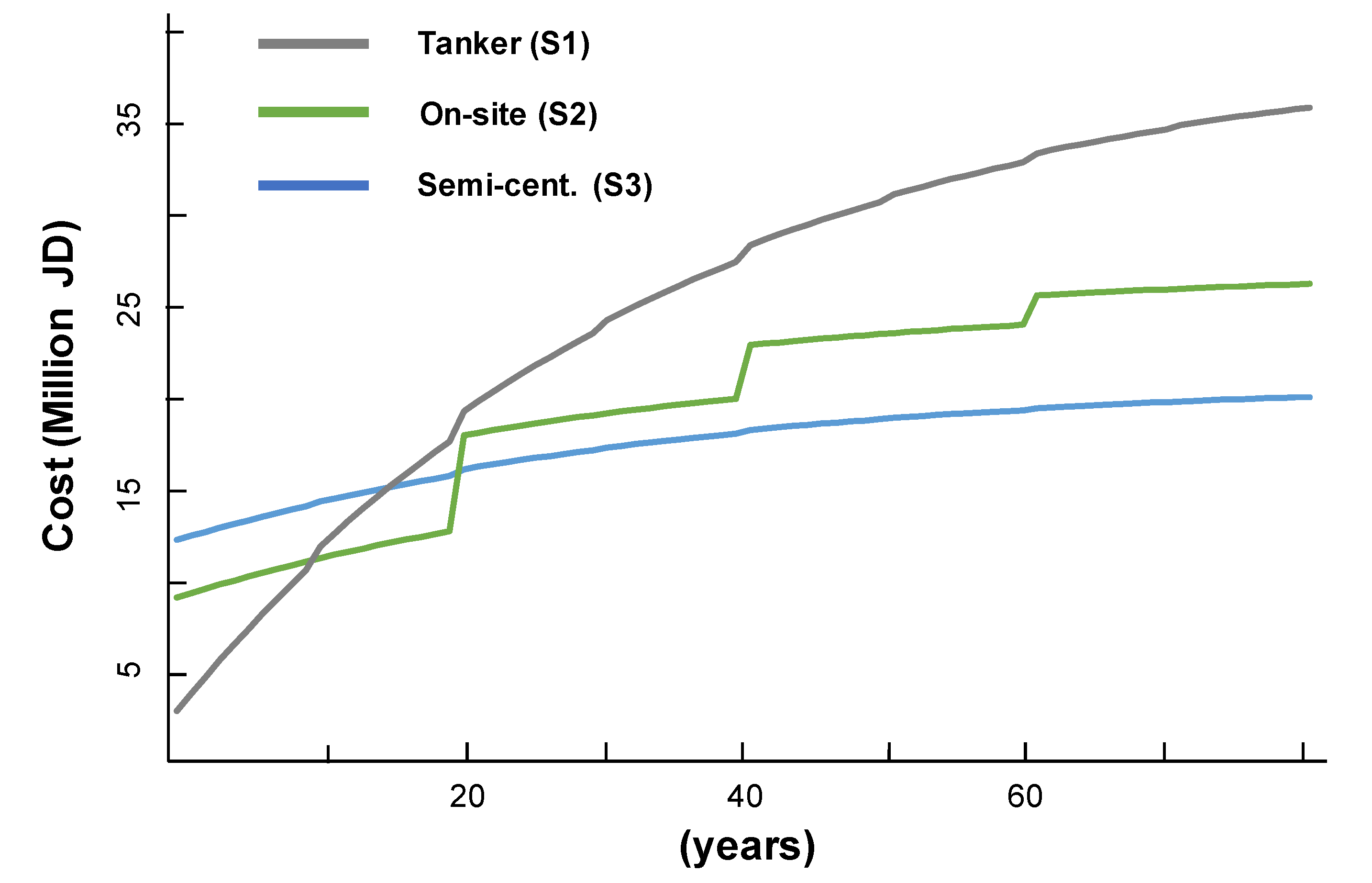
2.6. Economical Assessment

The costs for implementing infrastructure were estimated in terms of investment, re-investment and operation and maintenance (O and M), following the spatial GIS data. Local/international benchmark cost items were used and the Net-Present-Value was calculated for each scenario according to [16].
Calculations of the economic assessment were conducted as described by Khurelbaatar, et al. [18]. The lifespan of the gravity sewer network was considered to be 80 years, 40 years for the pumping stations and the decentralized wastewater treatment plant and 20 years for on-site wastewater treatment systems as well as the septic tanks. Reinvestment costs for mechanical equipment were considered to be renewed every 10 years (Table 1). It was considered that the reinvestment costs for the wastewater treatment plants are 20% of the initial construction cost per reinvestment interval and the O and M costs for the gravity sewer lines were assumed to be 1%, for the pumping station 15% and the on-site wastewater treatment plants were considered to account for 5% of the construction cost (Table 1). Other costs such as planning and design, overheads and profit, and contingency were also included (Table 1).

2.7. Population Growth, Water Demand and Wastewater Generation

According the Jordanian Department of Statistics (DOS), it is assumed that the population of Jordan will continue to increase at an annual rate of 2.1%. Therefore, this rate was used to predict population growth in the district of Bani Kinana up to the year 2050.
Data on the number of Syrian refugees was only available for the year 2015 and the assumption for the calculation of the population up to 2050 was that all Syrian refugees will remain in the district. In order to predict the future water demand, non-revenue water (NRW) needs to be considered. Non-revenue water is the sum of the administrative losses and leakages, including unbilled and unauthorized consumption, metering inaccuracies, data errors, loss through pipe joints, tank leakages, or other physical system losses [19]. The difference between the system input volumes and the allocated water (billed, authorized consumption) is NRW. For the Irbid Governorate, NRW was estimated to be as high as 52% [19].
The Jordanian “National Water Strategy” [20] recommends a supply rate of drinking water for rural areas of 100 L per day and capita (L/d/cap). However, currently, the MWI divides the supply rates as follows: 120 L/d/c for Amman, 100 L/d/c for the governorate’s urban areas and 80 L/d/c for rural areas [19]. Therefore, the overall water demand for the district of Bani Kinana was projected to be 80 L/d/c and this was taken into consideration when modeling the water demand per village [21]. Data on the water network and well abstraction rates were provided by the Water Authority of Jordan (WAJ) and MWI.
A main sewer network does not exist in the district of Bani Kinana and all generated wastewater is stored in septic tanks, which in general have to be emptied by tanker trucks on a regular basis, costing about 40 Jordanian Dinar [14]. The daily wastewater production has been calculated using the projected water demand of 80 L d−1 and capita and with the assumption that approximately 20% will not end up as wastewater. Therefore, a wastewater production rate of 64 L d−1 cap−1 has been considered when modeling the wastewater generation for each village in the district of Bani Kinana [22].

3. Results and Discussion

Integrated wastewater management systems are crucial for Jordan and should always be seen as being complementary to central wastewater treatment systems. These systems can be flexibly implemented and adapted to uncontrolled settlement dynamics as is the case in rural areas of Jordan. Local conditions such as topography, hydrology, population dynamics, reuse options and existing infrastructure need to be considered for rural and suburban wastewater infrastructure planning.

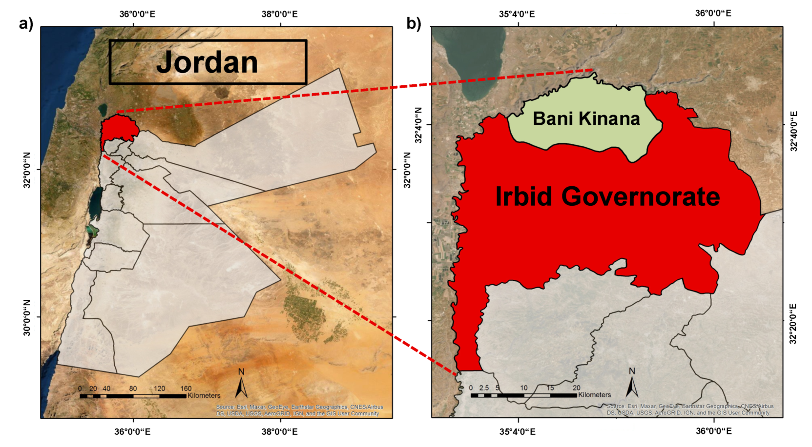
3.1. Irbid Governorate

The Irbid Governorate is located in the north of Jordan (Figure 1), has an area of 1572 km2 and is characterized by a moderate climate in the summer and by a cool and rainy winter. It is the second largest Governorate in terms of population, after the Amman Governorate. The Governorate contains nine districts: Irbid Qasabah, Ramtha, Al-Koura, Bani Kinana, Aghwar Shamaliyah, Bani Ubaid, Mazar Shamali, Taybeha and Wastiyyah. The overall population in 2014 of 1.7 million is expected to increase to approximately 2.2 million by 2025. The Irbid Governorate is served by five water systems managed by the Yarmouk water company, which is also responsible for its entire wastewater management [23]: (i) Irbid main water system: Qasabet Irbid, Wastiyyah, Tayybeh, Mazar Shamali, Bani Obaid and one locality from Koura district (Khirbet El-Hawi); (ii) Irbid- Kinana water system: Bani Kinana district, and one locality from Irbid district (Kufr Jayez); (iii) Irbid-Koura water system: Koura district: (iv) Irbid-Ramtha water system: Ramtha district and (v) Irbid-Shouna water system: North Shouna district and two localities from Bani Kinana district (Mukheibeh El-Tehta and Hemah Aurdinyah (Mukheibeh El-Foaqa).
The total water supply for Irbid Governorate in 2014 was about 46 MCM, however, the total water supply requirement in 2025 is estimated to be 108 MCM [24]. A total of six centralized wastewater treatment plants are located in the Irbid Governorate, specifically in (i) North Shouna; (ii) Wadi Al-Arab, (iii) Central Irbid, (iv) Wadi Shallala, (v) Ar-Ramtha and (vi) Wadi Hassan. The groundwater vulnerability in the Irbid Governorate is mostly classified as moderate. In the south and west of Irbid, the A7/B2 aquifer outcrops and exhibits very high vulnerability in the incised wadis, where distance to the groundwater is lower. Vulnerability is very low in areas where the B3 aquifer outcrops and is moderate to very high in the north and east of the governorate, where the B4/5 aquifer outcrops, again strongly influenced by the occurrence of wadis [6].

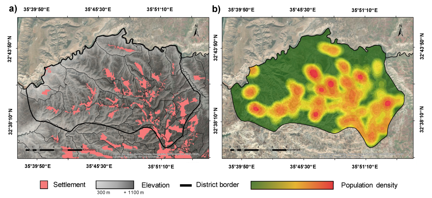
3.2. Population Distribution

The district of Bani Kinana is located in the northern part of the Governorate of Irbid. It comprises an area of about 282 km2 and can be divided into 25 sub-districts/villages, which are as follows: Abu Allogus; Al Berz/Kufur Jayez; Al Essheh/Saham; Al Mansourah/Malka; Al Mukheiba Al Fawqa; Al Mukheiba Al Tahta; Al Mzaireeb/Sama; Al Rafid; Al Seleh/Khraibeh; Al Yarmouk; Al Zawyeh/Kharja; Aqraba; Brishta, Ezrit; Harima; Harta; Hatem; Hibras; Ibdir; Kufur Soum; Qasfeh; Samar; Um Qais and Yibla (Figure S1). The villages are rather small and the overall population varies from 783 inhabitants in Brishta to 17,208 inhabitants in Al Mansourah/Malka according to census data [25]. A significant population increase was caused by the Syrian crisis. About 137,000 people have settled in the district of Bani Kinana, increasing the pressure on the scarce water resources (Table 2), reaching up to 22% (Al Zawyeh/Kharja), 21% (Harta) and 17% (Yibla) of the total population in some of the sub-districts.
Due to the topography of the region, settlements are highly scattered and villages were predominately built on/along mountain ridges with some scattered villages in the east (Al Mukheiba Al Fawqa and Al Mukheiba Al Tahta), the north (Aqraba) and the west (Al Yarmouk) (Figure 2). A high population density of more than 10,000 inhabitants can be found in cities such as Al Mansourah/Malka Kufur Soum, Al Essheh/Saham, Al Zawyeh/Kharja and Al Mzaireeb/Sama.

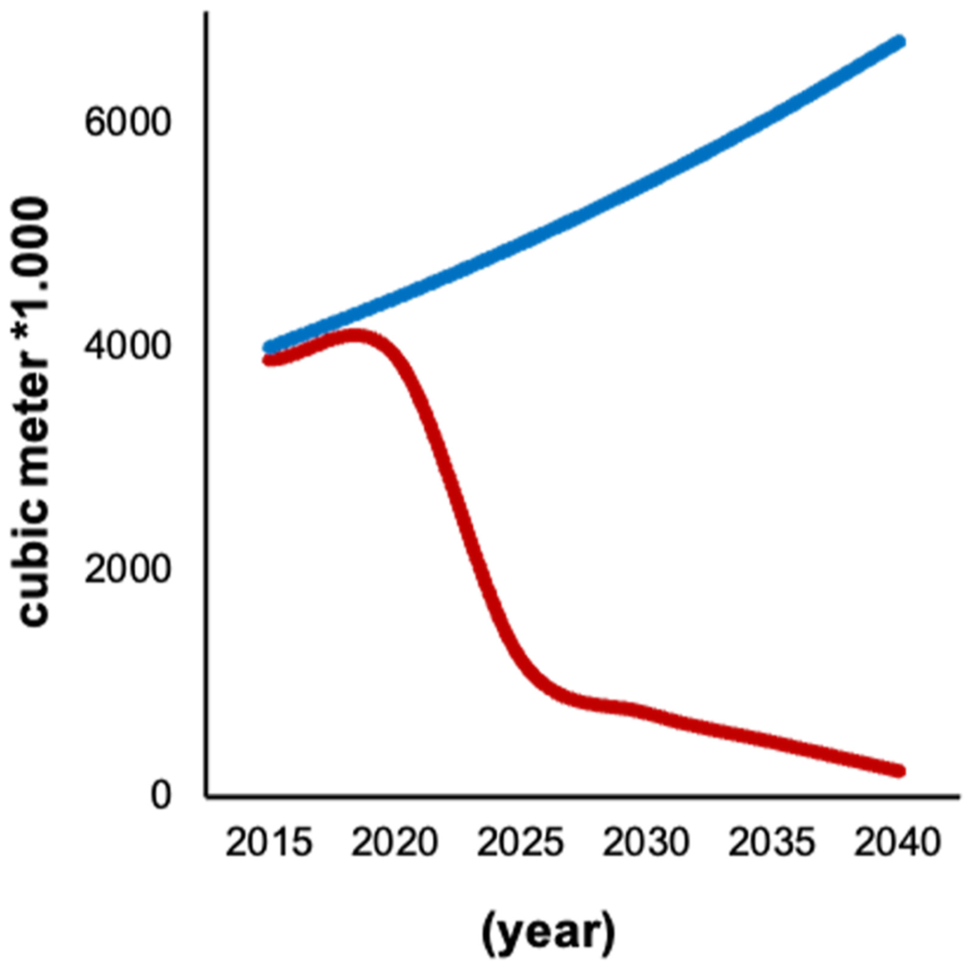
3.3. Water Demand and Wastewater Projection

Based on the assumption that the Jordanian population will continue to grow at an annual rate of 2.1%, the population of the district of Bani Kinana will more than double by the year 2050 (Table 3). This will have an enormous effect on future water demand as well as on future wastewater generation, putting more pressure on the local water resources. Based on the water supply subscription register, which was provided by the Yarmouk water company, the average number of inhabitants per building was estimated to be 8.2, and they are supplied with water once a week [10]. It can be expected that the water demand will increase from about 4.0 MCM to up to 8.3 MCM and the wastewater that will be generated and that requires collection and treatment could increase from 2.6. MCM to 5.3 MCM (Table 3). Bearing in mind the fact that none of the buildings are currently connected to a wastewater network, most untreated wastewater will directly infiltrate into the soil due to leaking septic tanks, thus contaminating groundwater resources. If the septic tanks were to be emptied by tanker trucks on a regular basis, the large amount of wastewater would have to be transported to one of the central wastewater treatment plants close by, such as Wadi Al-Arab or Central Irbid; however, they would not be able to manage the extra wastewater without being upgraded [7].
Increasing the water supply in Bani Kinana to meet the increased demand as well as a proper wastewater management plan to reduce the hazards resulting from septic tanks were identified by the European Investment Bank as the highest priority [10]. Leaking and overflowing septic tanks as well as the illegal dumping of sewage by tankers continues to contaminate wells and groundwater aquifers in this region, leading to wells becoming unusable and drinking water often having to be purchased from outside. Furthermore, one of the main problems at the community level in the Bani Kinana district is the non-equitable allocation of water resources and water theft. In summer in particular, water is cut off on a regular basis for several days/weeks and citizens are forced to buy water from the private sector, without being privy aware of its source [10].

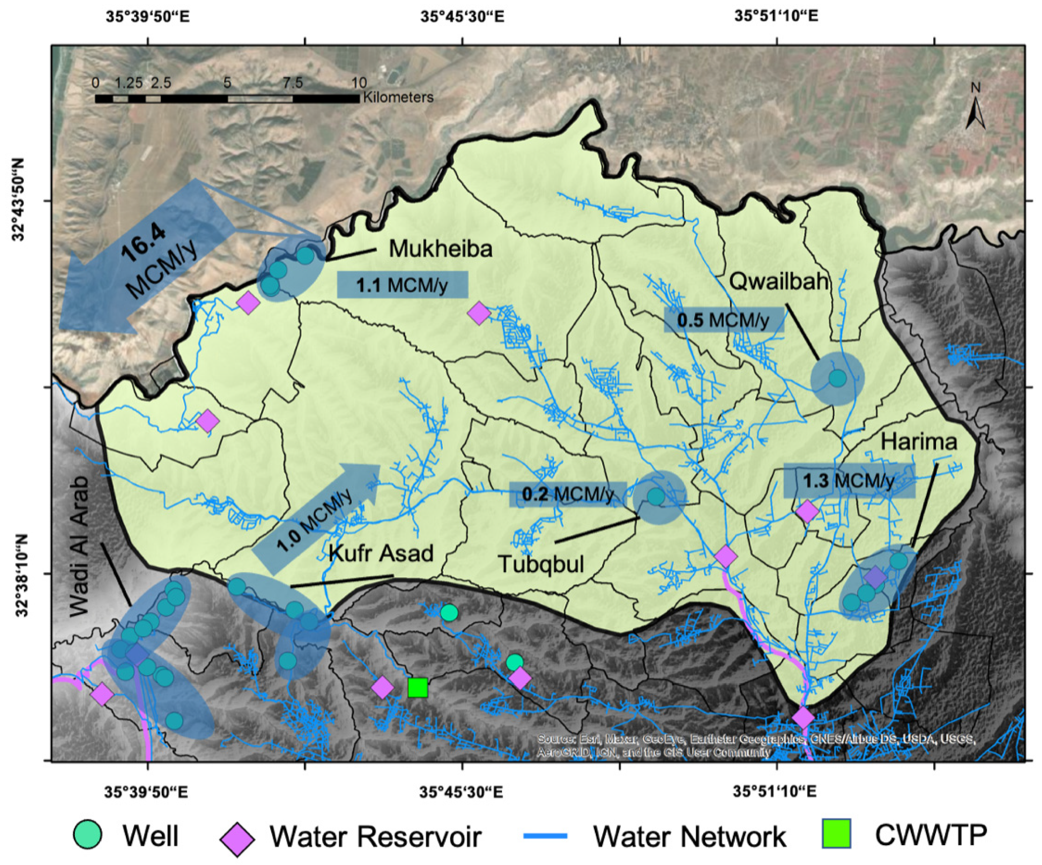
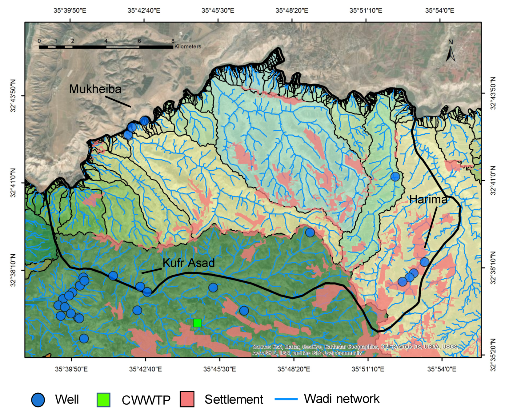
3.4. Vulnerable Water Resources

The district of Bani Kinana receives its freshwater from the following five groundwater wells/wellfields: (i) Harima, (ii) Kufr Assad, (iii) Qwailbah, (iv) Tuqbul and (v) Mukheiba, of which Harima, Kufr Assad and Mukheiba provide the largest amount of freshwater (Figure 3).
In the study by Breulmann et al. [6], the Harima and Kufr Assad wellfields were both classified as Hot Spots. Since both wellfields serve as drinking water reservoirs for the district of Bani Kinana, the installation of impermeable septic tanks at all houses, or the implementation of integrated wastewater treatment systems would have a significant positive impact on both wellfields. Furthermore, the Wadi Al Arab WWTP currently does not meet the effluent limits according to the Jordan Standard [26] and could, therefore, potentially threaten the Kufr Assad wellfield due to the leakage of treated wastewater from the transfer pipeline.
-
The Harima wellfield is located in the eastern part of the Bani Kinana district. About 1.3 MCM of water is obtained per year, allocating water to Kharja, Bawakis, Hareema, Khair, Qaseef, Sila, Kharib, Yarmouk Hospital, Sama Al-Rousan. It suffers from contamination with coliform, and shows high electrical conductivity and turbidity, and may be contaminated with Molybdenum, Nickel, Arsenic (Source: WAJ Laboratory 2020).
-
The Kufr Assad wellfield is located south of the Bani Kinana districts. About 1.0 MCM of water per year is obtained, allocating water to Kufr Asad, Sidour, Al-Kharaj, Malakah, Mansoura, Hatem, Abder, Umm Qais. It suffers from high turbidity and contamination with coliform bacteria from the Wadi Arab WWTP (Source: WAJ Laboratory 2020).
-
The Mukheiba wellfield is located in the west of the district of Bani Kinana, allocating about 1.1 MCM of water per year to the district of Bani Kinana. It suffers from contamination with coliform bacteria (Source: WAJ Laboratory 2020).
-
Qwailbah and Tuqbul are located in the center of the district of Bani Kinana and only contribute a small amount of freshwater to the district, of 0.5 MCM and 0.2 MCM, respectively. They suffer from contamination with coliform bacteria and from high turbidity levels (Source: WAJ Laboratory 2020).
In agreement with the study by Breulmann et al. [6], the highest potential hazard risks were calculated for the Mukheiba wellfield (R = 52), which provides drinking water to the district of Bani Kinana but also directs large amounts of water towards the upper Jordan Valley (Table 4).

3.5. Water Balance

All villages in the district of Bani Kinana are currently supplied with potable water once a week, while some villages receive water for a total duration of just 4 hours and up to 24 h based on the current water supply (Source: Yarmouk Water Company). The district of Bani Kinana receives its water from local groundwater wells/wellfields, and it is then pumped into the distribution network.
The groundwater of the Harima and Kufr Assad wellfield as well as the Qualiba well is entirely utilized by the Bani Kinana district, whereas the Mukheiba well is shared with the district of North Shouna. Overall, from the local groundwater wells/wellfields, about 3.4 MCM/year (Source: YMWC; 2015) is extracted, serving a total of 137.263 inhabitants. After accounting for NRW, and applying a factor of 80% on the net quantities, only 54 L per capita is achieved from the groundwater wells/wellfields. However, the water demand for the year 2015 was already about 4.0 MCM, leaving a shortfall of 0.6 MCM of water that had to be supplied by tankers (Table 3; Figure 3). Due to expected decreasing well/wellfield extraction volumes (Figure 4), it will be difficult to meet the calculated demand of about 8.3 MCM/y for the year 2050.
Since the wells/wellfields extraction volume will dramatically decrease by 2050, as postulated by Margane and Al Dweiri [23] and WMI [19], every single drop of water has to be used in the region to fulfil the future demands of a vastly growing population (Figure 4). Since large amounts of drinking-quality water are directed in open channels towards the Jordan Valley for irrigation, where a significant amount is lost on the way due to infiltration and evapotranspiration, it is strongly recommended that this water is retained in the north. An additional 16.4 MCM/year of water would serve the 2050 population of Bani Kinana and almost half could still be directed towards the Jordan Valley. Therefore, solutions need to be developed to (i) stop the over abstraction of existing wells/wellfields; (ii) rehabilitate and protect existing wells/wellfields and (iii) find a sustainable way to distribute the water from the Mukheiba well/wellfield to the district of Bani Kinana.

3.6. Integrated Wastewater Management Scenarios

With an increasing drinking water demand, more wastewater will be generated that has to be treated. By the year 2050 wastewater generation will more than double and will increase from about 2.6 MCM/y in 2015 to about 5.3 MCM/y (Table 3) in the district of Bani Kinana. Due to the critical level of water scarcity and the increasing drinking water demand, the Jordanian water sector needs cost efficient and optimized solutions to reduce losses, protect groundwater resources and to promote the reuse of existing resources such as treated wastewater. Special attention should be given to areas in most need, based on vulnerability maps [6,27].
It can be assumed that the absence of a main sewer network in the district of Bani Kinana will further contribute to the contamination of groundwater resources because of the infiltration of untreated wastewater from septic tanks and cesspools, as described by Grimmeisen, et al. [28] for the As-Salt area in Jordan. Septic tanks have to emptied by tanker trucks on a regular basis, which is associated with high costs [14,18]. It has also been reported that only about 4% of the septic tanks in Jordan are emptied by tanker trucks and treated in centralized wastewater treatment plants, whilst the contents of the remaining 96% seep into the groundwater [29]. If the septic tanks are emptied, the wastewater is transported to nearby centralized wastewater treatment plants, where the treated wastewater is, in general, not directly reused [7]. The wadi networks (macro-catchments) that have been identified (Figure 5) show that the Kufr Assad wellfield is predominately impacted by buildings located outside of the district of Bani Kinana, and therefore, scenarios have been developed for the micro-catchment area of the Harima well/wellfield in this study.
Within the calculated micro-catchment of the Harima wells/wellfield, groundwater is currently only extracted from four wells, providing about 1.3 MCM/y to the district of Bani Kinana (Figure 4 and Figure 6). There are 1007 houses located in the catchment area, with approximately 8.2 people per building and four denser housing clusters. The area is hilly and enclosed by mountains in the west and east, leading to natural water flow into a valley in the north east (Figure 6). An overview of the area and of the individual wells in the Harima micro-catchment is presented in Figure S2.
For the development of the tanker (S1) and the on-site (S2) scenarios, all 1007 buildings in the Harima micro-catchment were considered to be served individually. The design capacity of the wastewater treatment units on-site was 10 PE per building. The tanker-based scenario (S1) includes newly sealed septic tanks for each house. Furthermore, the frequency of tanker service was considered to be 15 days, at which time the wastewater would be transported to the nearest centralized WWTP.
For the semi-centralized scenario (S3), all identified buildings were connected to a main sewage network. The wastewater was then directed by gravity to a new wastewater treatment plant in the north of the Harima catchment, following the natural water flow direction (Figure 6c and Figure 7). Due to the challenging topography of the region, individual houses or groups/clusters of houses require an additional pumping of the wastewater to ensure the connectivity to the WWTP. The resulting length of the sewer network is estimated to be 74 km with 72 lifting stations. Out of these 72 lifting stations, 35 serve less than 10 buildings, 27 serve less than 100 buildings and only 10 pump the equivalent of more than 100 buildings, with12 pumping about 100–654 m3/day and the rest in the range of 1–95 m3/day.
Figure 8 and Table 5 show the cumulative calculated costs of the scenarios in net-present-value per year for a lifespan of 80 years and provide an estimate of the investment and O and M costs of the wastewater network, lifting stations, wastewater treatment plant, tanker transport system, and for an upgrade of the septic tanks. The results clearly show that the costs for the tanker scenario (S1) are the highest (Figure 8, Table 5), with calculated specific treatment costs of 4.96 JD/m3. Scenarios 2 and 3 show a constant offset; however, the tanker scenario starts with the lowest costs (approximately 3.0 million JD), with an upgrade of all existing septic tanks included in the calculations. However, the costs increase substantially due to the higher operation and maintenance costs for the tanker fleet, already exceeding the costs for Scenario 2 and Scenario 3 after 10–15 years, making Scenario 1 highly inefficient in the long-term. Nevertheless, most probably because of the low starting investment costs, the tanker scenario is the most widespread practice in the region.
The most cost-effective scenario for the Harima micro-catchment was the semi-centralized one (S3). The costs are on a similar level for the first 20 years compared to the on-site Scenario (S2); however, they only slowly increase over the years. Due to the high re-investment costs after 20 years for the on-site Scenario (S2) of approximately 6.8 million JD, the costs increase significantly, exceeding the cost of Scenario (S3) with calculated specific treatment costs of 3.72 JD/m3 (Table 5). Although the assumption was to connect every single building to a network and the quantity of pumping stations in S3 being relatively high, as shown in Figure 7b, the scenario is still significantly cheaper, with calculated specific treatment costs of 2.77 JD/m3 (Table 5).
The results show that the ALLOWS tool enables the rapid identification of cost-effective local wastewater management solutions for a specific area by using the combination of spatial and economic analyses, thereby protecting the groundwater wells/wellfield of Harima. In general, the costs depend strongly on the length of the designed wastewater network, which in turn is highly dependent on the topography and population/building density. Building an entirely new network, is generally associated with high costs as concluded by Maurer, et al. [30]; however, the developed semi-centralized scenario (S3) was still the most inexpensively scenario for the Harima micro-catchment. As described by Khurelbaatar et al. [18], the wastewater management scenarios have been conducted with the least possible input data, however, the incorporation of further elements such as groundwater protection zones, local legal frameworks, as well as various reuse strategies is possible [6,27]. Furthermore, for the present study, only one wastewater treatment technology was considered for the calculations, although numerous technologies exist [11] and could be included and compared to meet, for example, country-specific reuse requirements.

4. Conclusions

This study presents a comprehensive analysis of the overall situation in relation to water, as well as the development of an integrated wastewater management approach in the district of Bani Kinana (Irbid Governorate; Jordan), aimed at protecting vulnerable water resources and promoting sustainable groundwater abstraction and the conservation of groundwater resources to reduce the level of risk to local communities and ecosystems. The district of Bani Kinana has accommodated a high number of Syrian refugees in the past, which placed enormous pressure on local groundwater resources. The district of Bani Kinana is not connected to a main wastewater network. Most wastewater is stored in septic tanks, which are not sealed properly and therefore, contaminate the groundwater. As projected, water demand will significantly increase in the coming years and groundwater consumption already exceeds its replacement. Due to the expected decreasing well/wellfield extraction volumes, it will be impossible to meet the expected demand in the year 2050. Since large amounts of drinking quality water are directed towards the Jordan Valley for irrigation from the Mukheiba well/wellfield, it can be assumed that a significant amount is lost on its way due to infiltration and evapotranspiration. Therefore, it is strongly recommended that this water is retained in the district of Bani Kinana to meet the actual and projected future demand of up to 8.3 MC in the year 2050. It is also recommended that, as a first step, vulnerable water resources are protected from contamination by appropriate wastewater treatment management, and that investments by the Jordanian Government are also directed to rural areas.
In this study, the most cost-effective wastewater treatment system solution was identified to address the groundwater vulnerability of the Harima wells/wellfield, which serves as the main drinking water resource in the district of Bani Kinana. The assessment of the wastewater treatment management solutions revealed that the tanker-based solution currently in place is not a suitable one in the long-term. It is the costliest scenario in the long-term and under the current circumstances, as leaking septic tanks cause the pollution of groundwater resources. Hence, tailored solutions are urgently needed, such as the implementation of a cost-effective semi-centralized wastewater treatment approach, through the use of which the main impact of groundwater pollution by the infiltration of raw wastewater can be significantly reduced. The development of certified wastewater treatment systems will additionally ensure that these systems are constructed and operated/maintained to meet local regulations/standards in order to contribute to the protection of groundwater resources [31].
This study can be seen as a blueprint for applying the used methods in the region. Moreover, due to the methods already installed and used at the MWI, the insights gained can easily be transferred to other regions in the Middle East and in Europe.

Supplementary Materials

The following supporting information can be downloaded at: https://www.mdpi.com/article/10.3390/su14063574/s1. Figure S1. The 25 sub-districts of the district of Bani Kinana; Figure S2: Overview of the study area and pictures of the individual wells in the Harima micro-catchment, May 2021.

Author Contributions

Conceptualization, M.B.; methodology, software and validation M.B., G.K. and M.S.; visualization M.B. and M.S.; writing—original draft preparation, M.B.; writing—review and editing, M.B., G.K., M.S., M.v.A., A.S. and R.A.M.; project administration and funding acquisition, M.B., M.v.A. and R.A.M. All authors have read and agreed to the published version of the manuscript.

Funding

This work was supported by a grant from the Federal Ministry of Education and Research (BMBF–FKZ: 02WM1458) within the context of the NICE II-Project: Implementation Office Amman.

Institutional Review Board Statement

Not applicable.

Informed Consent Statement

Informed consent was obtained from all subjects involved in the study.

Data Availability Statement

Not applicable.

Acknowledgments

We thank the staff at the Jordanian Ministry of Water and Irrigation and the Water Authority of Jordan for providing data and reports for the analysis as well as their support in obtaining data from the Department of Statistics. We are particularly grateful for support provided by H.E. Eng. Ali Subah and Eng. Mohammad Al-Dweiri at the Ministry of Water and Irrigation, H.E. Iyad Dahiyat at the Water Authority of Jordan and Eng. Anwar Al Subeh for her support in the Implementation Office.

Conflicts of Interest

The authors declare no conflict of interest.

References

  1. UNESCO; UN-Water. The United Nations World Water Development Report 2020: Water and Climate Change; UNESCO: Paris, France, 2020; p. 198. Available online: https://www.unwater.org/publications/world-water-development-report-2020/ (accessed on 12 January 2022).
  2. UN. Transforming our World: The 2030 Agenda for Sustainable Development (A/RES/70/1); United Nations: New York, NY, USA, 2015. [Google Scholar]
  3. Breulmann, M.; Müller, R.A.; Al-Subeh, A.; Subah, A.; van Afferden, M. Influx of Syrian Refugees in Jordan | Effects on the Water Sector; The Helmholtz Centre for Environmental Research–UFZ with Support of the Ministry of Water and Irrigation: Amman, Jordan; Leipzig, Germany, 2021. [Google Scholar]
  4. Hussein, H.; Natta, A.; Yehya, A.A.K.; Hamadna, B. Syrian Refugees, Water Scarcity, and Dynamic Policies: How Do the New Refugee Discourses Impact Water Governance Debates in Lebanon and Jordan? Water 2020, 12, 325. [Google Scholar] [CrossRef] [Green Version]
  5. Baylouny, A.M.; Klingseis, S.J. Water Thieves or Political Catalysts? Syrian Refugees in Jordan and Lebanon. Middle East Policy 2018, 25, 104–123. [Google Scholar] [CrossRef]
  6. Breulmann, M.; Brückner, F.; Toll, M.; van Afferden, M.; Becker, M.-Y.; Al-Subeh, A.; Subah, A.; Müller, R.A. Vulnerable Water Resources in Jordan: Hot Spots; Ministry of Water and Irrigation with Support from the Helmholtz Centre for Environmental Research–UFZ and the Federal Institute for Geosciences and Natural Resources (BGR): Amman, Jordan; Leipzig, Germany; Hannover, Germany, 2020; p. 51. [Google Scholar]
  7. Breulmann, M.; Müller, R.A.; Al-Subeh, A.; Subah, A.; van Afferden, M. Reuse of Treated Wastewater and Biosolids in Jordan—Nationwide Evaluation; Helmholtz Centre for Environmental Research–UFZ with Support from the Ministry of Water and Irrigation: Amman, Jordan; Leipzig, Germany, 2020; p. 100. [Google Scholar]
  8. MWI. Decentralized Wastewater Management Policy. In National Water Strategy 2016–2025 of Jordan; Ministry of Water and Irrigation Supported by the Helmholtz Centre for Environmental Research-UFZ: Amman, Jordan, 2016. [Google Scholar]
  9. MWI. The National Framework for Decentralized Wastewater Management; Ministry of Water and Irrigation for the The National Implementation Committee for Effective Decentralized Wastewater Management in Jordan: Amman, Jordan, 2015. [Google Scholar]
  10. EIB. Feasibility Study for Bani Kenaneh Water Supply and Sanitation Project: Gender Analysis—Action Plan; This Technical Assistance Operation Is Financed by FEMIP Trust Fund/Climate Action Envelope CAMENA (TA2017032 JO FTF) and Supported by the European Investment Bank, The EU Bank, European Union and UK Aid and Was Coordinated by Engicon, Atkins Acuity and Hcl Consultants; EIB: Amman, Jordan, 2019; p. 30. [Google Scholar]
  11. Crites, R.; Tchobanoglous, G.; Nolte, G.S.; Associates. Small & Decentralized Wastewater Management Systems; McGraw-Hill Companies, Inc.: New York, NY, USA, 1998. [Google Scholar]
  12. van Afferden, M.; Cardona, J.A.; Lee, M.Y.; Subah, A.; Müller, R.A. A new approach to implementing decentralized wastewater treatment concepts. Water Sci. Technol. 2015, 72, 1923–1930. [Google Scholar] [CrossRef] [PubMed]
  13. Brückner, F.; Hamdan, I.; Brezat, A. Explanatory Notes for the Groundwater Vulnerability Map of Jordan (Middle and Shallow Aquifier Systems); Federal Institute for Geosciences and Natural Resources (Bundesanstalt für Geowissenschaften und Rohstoffe or BGR); Jordanian Ministry of Water and Irrigation; Federal Ministry for Economic Cooperation and Development (Bundesministerium für Wirtschaftliche Zusammenarbeit und Entwicklung, BMZ): Amman, Jordan, 2018. [Google Scholar]
  14. Clemens, M.; Khurelbaatar, G.; Merz, R.; Siebert, C.; van Afferden, M.; Rodiger, T. Groundwater protection under water scarcity; from regional risk assessment to local wastewater treatment solutions in Jordan. Sci. Total Environ. 2020, 706, 136066. [Google Scholar] [CrossRef] [PubMed]
  15. Abdulla, F.; Alfarra, A.; Abu-Qudais, H.; Sonneveld, B. Evaluation of Wastewater Treatment Plants in Jordan and Suitability for Reuse. Acad. J. Environ. Sci. 2016, 4, 111–117. [Google Scholar] [CrossRef]
  16. DWA. Dynamic Cost Comparison Calculations for Selecting Least-Cost Projects in Water Supply and Wastewater Disposal—DCCC—Appraisal Manual for Project Designers; DWA Deutsche Vereinigung für Wasserwirtschaft, Abwasser und Abfall e.V.: Hennef, Germany, 2011. [Google Scholar]
  17. DWA. DWA-A 139 Einbau und Prüfung von Abwasserleitungen und–Kanälen; DWA Deutsche Vereinigung für Wasserwirtschaft, Abwasser und Abfall e.V.: Hennef, Germany, 2009. [Google Scholar]
  18. Khurelbaatar, G.; Al Marzuqi, B.; Van Afferden, M.; Muller, R.A.; Friesen, J. Data Reduced Method for Cost Comparison of Wastewater Management Scenarios-Case Study for Two Settlements in Jordan and Oman. Front. Environ. Sci. 2021, 9, 137. [Google Scholar] [CrossRef]
  19. WMI. National Water Supply Infrastructure Master Plan; This Document Was Produced for Review by the United States Agency for International Development and Was Prepared by Tetra Tech under the USAID Water Management Initiative (WMI); WMI: Burlington, Vermont, 2020; p. 355. [Google Scholar]
  20. MWI. National-Water Strategy of Jordan 2016–2025; Ministry of Water and Irrigation: Amman, Jordan, 2016. [Google Scholar]
  21. IRG. Institutional Support and Strengthening Program: National Strategic Wastewater Master Plan; The United States Agency for International Development (USAID); It Was Prepared by International Resources Group (IRG) for the Institutional Support & Strengthening Program (ISSP); IRG: Washington, DC, USA, 2013. [Google Scholar]
  22. USAID. Cost of Hosting Syrian Refugees on Water Sector of Jordan—Updates for 2017; United States Agency for International Development (USAID): Amman, Jordan, 2018; p. 34. [Google Scholar]
  23. Margane, A.; Al Dweiri, M. Rapid Assessment of the Consequences of Declining Resources Availability and Exploitability for the Existing Water Supply Infrastructure; The Deutsche Gesellschaft für Internationale Zusammenarbeit (GIZ) GmbH in Cooperation of the Ministry of Water and Irrigation (MWI): Amman, Jordan, 2020. [Google Scholar]
  24. USAID. Institutional Support & Strengthening Program: Strategic Master Plan for Municipal Water Infrastructure; United States Agency for International Development (USAID): Washington, DC, USA, 2015; p. 497. [Google Scholar]
  25. DOS. Final Results of the Cenus of Population and Housing; Department of Statistics: Amman, Jordan, 2015. [Google Scholar]
  26. JS 893; Jordanian Standard for Water—Reclaimed Domestic Wastewater. Jordan Standards and Metrological Organization: Amman, Jordan, 2006.
  27. MoPIC. Jordan Response Plan for the Syrian Crisis 2019; Ministry of Planning and International Cooperration: Amman, Jordan, 2019. [Google Scholar]
  28. Grimmeisen, F.; Lehmann, M.F.; Liesch, T.; Goeppert, N.; Klinger, J.; Zopfi, J.; Goldscheider, N. Isotopic constraints on water source mixing, network leakage and contamination in an urban groundwater system. Sci. Total Environ. 2017, 583, 202–213. [Google Scholar] [CrossRef] [PubMed]
  29. Dorsch. Feasability Study opn Decentralized Wastewater Treatment and Reuse Clusters on Regionla Scale in Jordan; Dorsch International Consultants GmbH: Amman, Jordan, 2014. [Google Scholar]
  30. Maurer, M.; Wolfram, M.; Anja, H. Factors affecting economies of scale in combined sewer systems. Water Sci. Technol. 2010, 62, 36–41. [Google Scholar] [CrossRef] [PubMed]
  31. Breulmann, M.; van Afferden, M.; Al-Subeh, A.; Al-Mahamid, J.S.; Dorgeloh, E.; Müller, R.A. National Framework: The Certification of Wastewater Treatment Systems with Capacities up to 5.000 PE in Jordan; Helmholtz Centre for Environmental Research–UFZ with Support of the Ministry of Water and Irrigation: Leipzig, Germany; Amman, Jordan, 2021; p. 252. [Google Scholar]
Figure 1. Geographical location of the district Bani Kinana: (a) the Hashemite Kingdom of Jordan with its 12 Governorates and (b) the Irbid Governorate in the north of Jordan with the district of Bani Kinana.
Sustainability 14 03574 g001
Figure 2. Bani Kinana, Irbid Governorate: (a) topography and settlement distribution and (b) population density.
Sustainability 14 03574 g002
Figure 3. Water infrastructure, active drinking water wells and the water extraction volume for the year 2019 in the district of Bani Kinana. CWWTP: central wastewater treatment plant; MCM/y: million cubic meter per year.
Sustainability 14 03574 g003
Figure 4. Projected water demand (blue) and wells/wellfield production (red) for the district of Bani Kinana, Irbid Governorate [19,23].
Sustainability 14 03574 g004
Figure 5. Individual wells, settlements, centralized wastewater treatment plant with delineation of the wadi networks (macro-catchments) in the district of Bani Kinana, Irbid Governorate.
Sustainability 14 03574 g005
Figure 6. Detailed analysis of the micro-catchment of the Harima wells/wellfield (a) overview, (b) contour lines, (c) wadi network, (d) building density and (e) road infrastructure. The four green points represent the location of the individual Harima wells.
Sustainability 14 03574 g006
Figure 7. (a) Scenario input data such as existing roads, buildings and elevation and (b) scenarios 1, 2 and 3 for the Harima wells micro-catchment area.
Sustainability 14 03574 g007
Figure 8. Top: Total calculated costs of the S1–S3 in net-present-value per year for a lifespan of 80 years.
Sustainability 14 03574 g008
Table 1. Cost items (Million JD) required for the economic scenario assessment.
Cost ItemsUnitLifespan
(y)
Constr.
(JD/m)
Tot. Invest.
(JD)
Reinvest. Period
(y)
Reinvest
(% inv./interval)
O&M
(% inv./y)
Unit O&M
Sewer network
Gravity sewer DN150m80703.6 Mill.-00.010.7/m
Gravity sewer DN200m801403.1 Mill.-00.010.7/m
Pumping stations-40-0.5 Mill.100.20.150.7/m
WWTP
WWTP–8257 PE-40-1.8 Mill.200.20.05-
On-site WWTP(SBR)-20-6.8 Mill.20--250 JD/y
Tanker
Septic tank upgrade-20-2.0 Mill.100.4-973 JD/y
Additional cost items
Planning and designing%--10% of construction costs
Overhead and profit%--10% of construction costs
Contingency cost%--15% of construction costs
Table 2. Distribution of the Jordanian (Jord.) and Syrian (Syr.) population in the settlements in Bani Kinana district for the year 2015 (Source: Department of Statistics).
Village/Sub-DistrictTotalJord.Syr.
Abu Allogus17921652140
Al Berz/Kufur Jayez54664816650
Al Essheh/Saham978284751307
Al Mansourah/Malka17,20815,0642144
Al Mukheiba Al Fawqa2803278716
Al Mukheiba Al Tahta3637361423
Al Mzaireeb/Sama758765321055
Al Rafid29712732239
Al Seleh/Khraibeh35262981545
Al Yarmouk82376954
Al Zawyeh/Kharja10,69083432347
Aqraba40633836227
Brishta783669114
Ezrit17121560152
Harima63405652688
Harta676253111451
Hatem94278526901
Hibras57664940826
Ibdir42473619628
Kufur Soum11,34910,2251124
Qasfeh1384130084
Samar55895075514
Um Qais61245612512
Yibla743261991233
Total137,263120,28916,289
Table 3. Population size, water demand and wastewater generation in the district of Bani Kinana between the years 2015 and 2050 (Source: Department of Statistics, Jordan); Water-D: Water demand, Water-G: Wastewater generation.
Village/Sub-DistrictPop.Water-D
CM/y
WW-G
CM/Y
Pop.Water-D
CM/y
WW-G
CM/Y
20152050
Abu Allogus179252,32633,4893709108,29869,311
Al Berz/Kufur Jayez5466159,607102,14911,313330,334211,414
Al Essheh/Saham9782285,634182,80620,246591,169378,348
Al Mansourah/Malka17,208502,474321,58335,6151,039,954665,571
Al Mukheiba Al Fawqa280381,84852,3825801169,397108,414
Al Mukheiba Al Tahta3637106,20067,9687527219,800140,672
Al Mzaireeb/Sama7587221,540141,78615,703458,515293,450
Al Rafid297186,75355,5226149179,550114,912
Al Seleh/Khraibeh3526102,95965,8947298213,092136,379
Al Yarmouk82324,03215,380170349,73731,832
Al Zawyeh/Kharja10,690312,148199,77522,125646,043413,468
Aqraba4063118,64075,9298409245,545157,149
Brishta78322,86414,633162147,32030,285
Ezrit171249,99031,9943543103,46466,217
Harima6340185,128118,48213,122383,154245,218
Harta6762197,450126,36813,995408,657261,541
Hatem9427275,268176,17219,511569,715364,617
Hibras5766168,367107,75511,934348,464223,017
Ibdir4247124,01279,3688790256,665164,265
Kufur Soum11,349331,391212,09023,489685,869438,956
Qasfeh138440,41325,864286483,64153,530
Samar5589163,199104,44711,567337,768216,171
Um Qais6124178,821114,44512,675370,100236,864
Yibla7432217,014138,88915,382449,148287,455
Total137,2634,008,0802,565,171284,0898,295,4005,309,056
Table 4. Extraction volumes and use of the groundwater wells/wellfields for the district of Bani Kinana (Source: Water Authority Laboratory 2019).
Domestic
MCM/y
Irrigation
MCM/y
Hareema1,270,765-
Kufr Asad1,004,702-
Qwailbah478,689-
Tubqbul145,922-
Mukheiba1,046,25415,326,496
Total3,946,33215,326,496
Table 5. Bottom: Summary of the net-present-value of the cost components (million JD) of the developed scenarios for the Harima micro-catchment.
S1 TankerS2 On-SiteS3 Semi-Centr.
Invest.O&M/yInvest.O&M/yInvest.O&M/y
Sewer network----6.80.07
Pumping stations----0.50.08
WWTP--9.20.31.80.10
Septic tank3.00.9----
Specific treat. costs (JD/m3)4.963.722.77
Publisher’s Note: MDPI stays neutral with regard to jurisdictional claims in published maps and institutional affiliations.

