
Testing the mHM-MPR Reliability for Parameter Transferability across Locations in North–Central Nigeria

 , ,
, ,  and
and
Abstract
1. Introduction
- What is the performance of gridded rainfall datasets over Nigeria?
- How does mHM perform across selected basins when forced with different gridded rainfall datasets?
- What is the performance of mHM when parameters are transferred from gauged to ungauged basins?
2. Methods
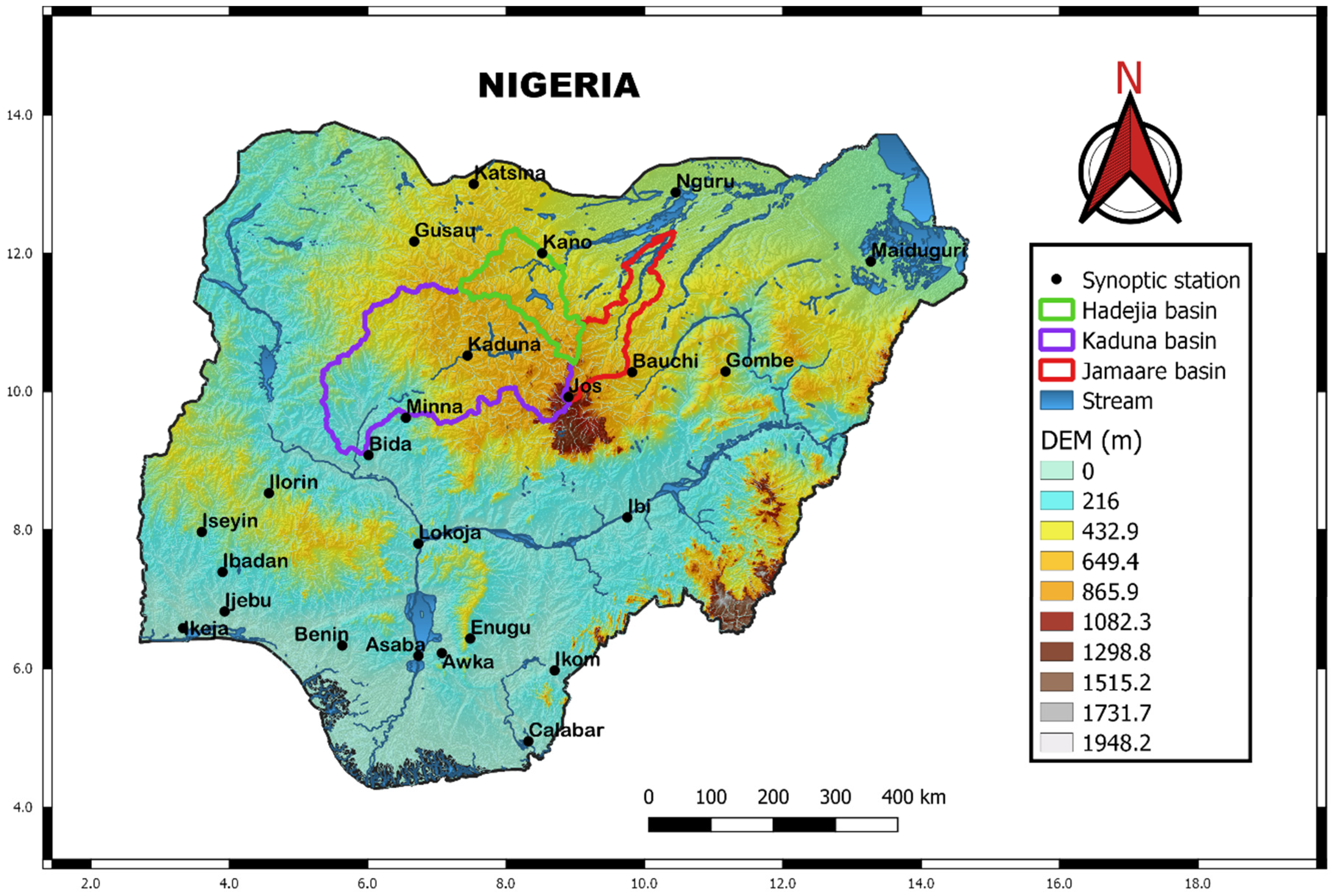
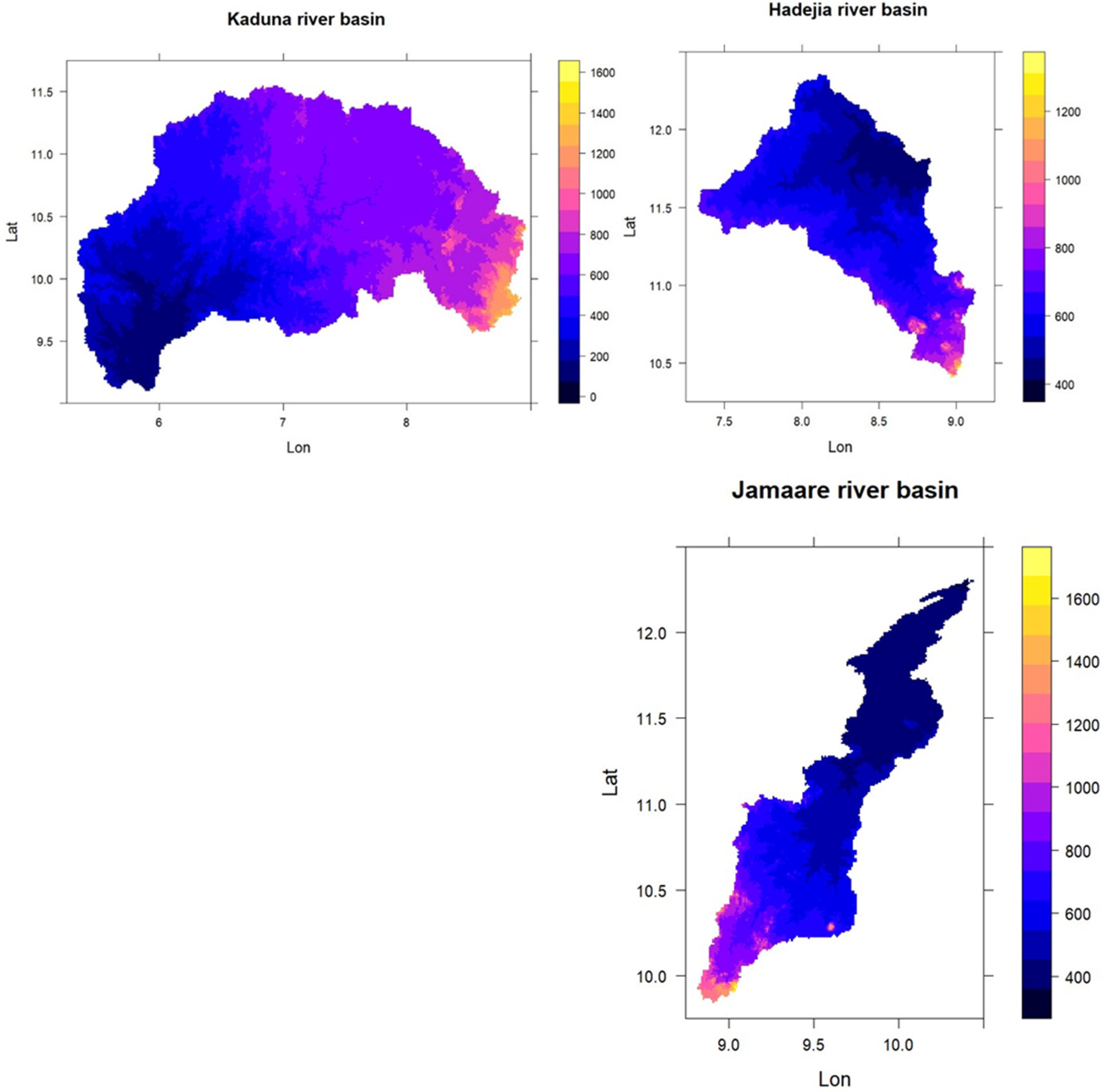
2.1. Study Area
2.2. The mHM-MPR Structure: Description
2.3. Data and Inputs
2.3.1. Morphological Datasets
2.3.2. Soil Data
2.3.3. Landuse
2.3.4. Meteorological Data
2.3.5. Discharge Data
2.3.6. Hydrologic Modeling Framework
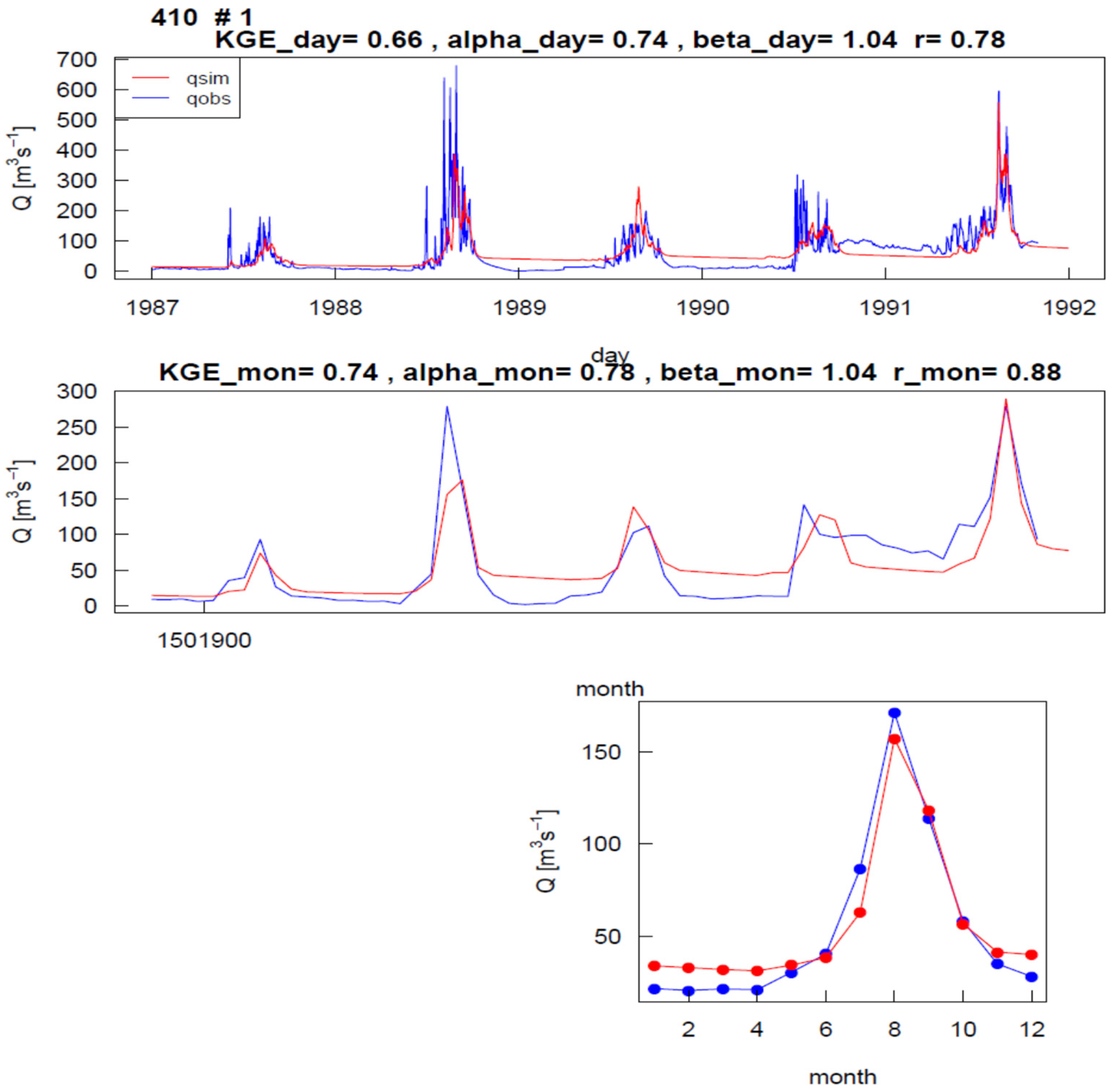
3. Results and Discussion
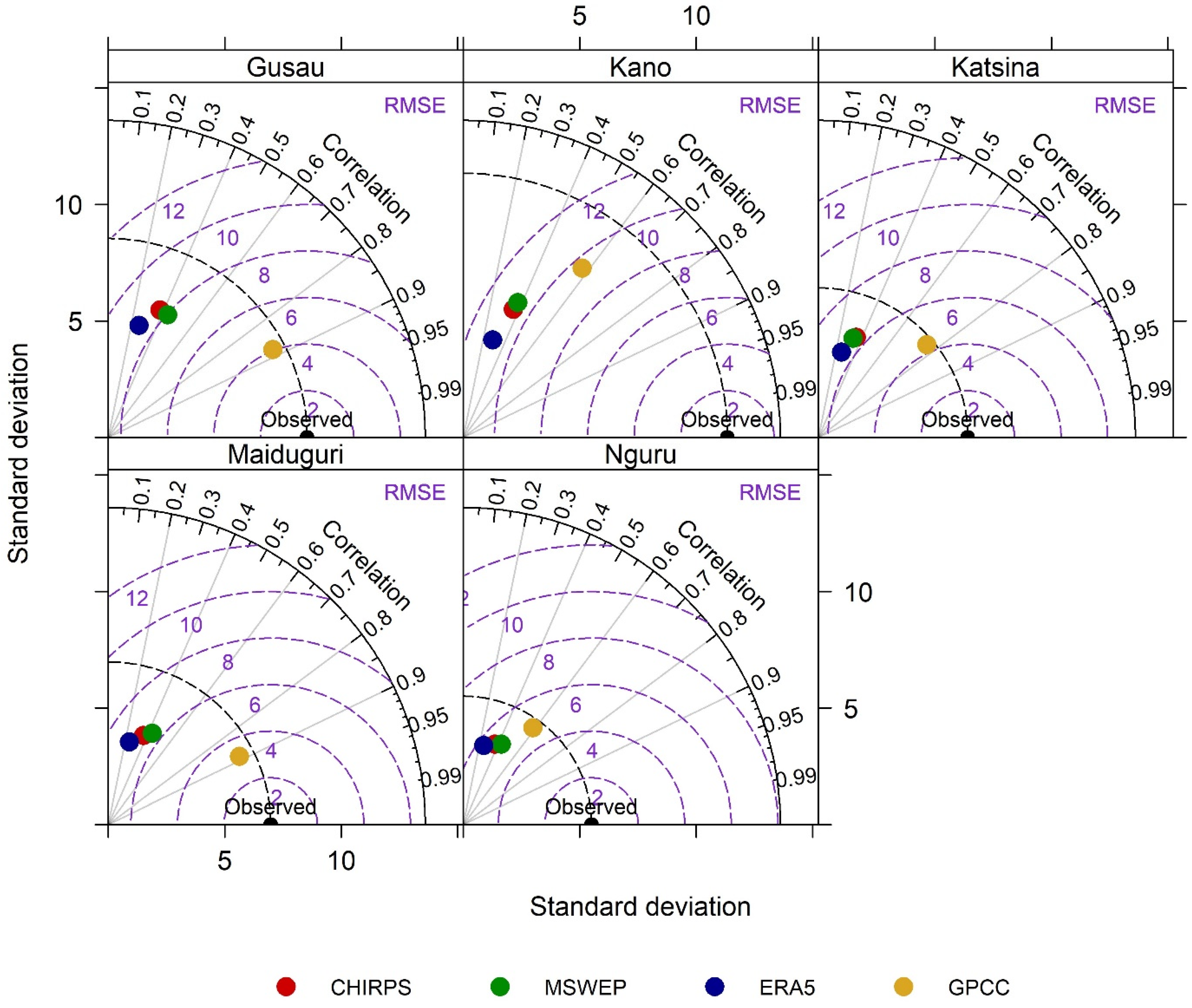
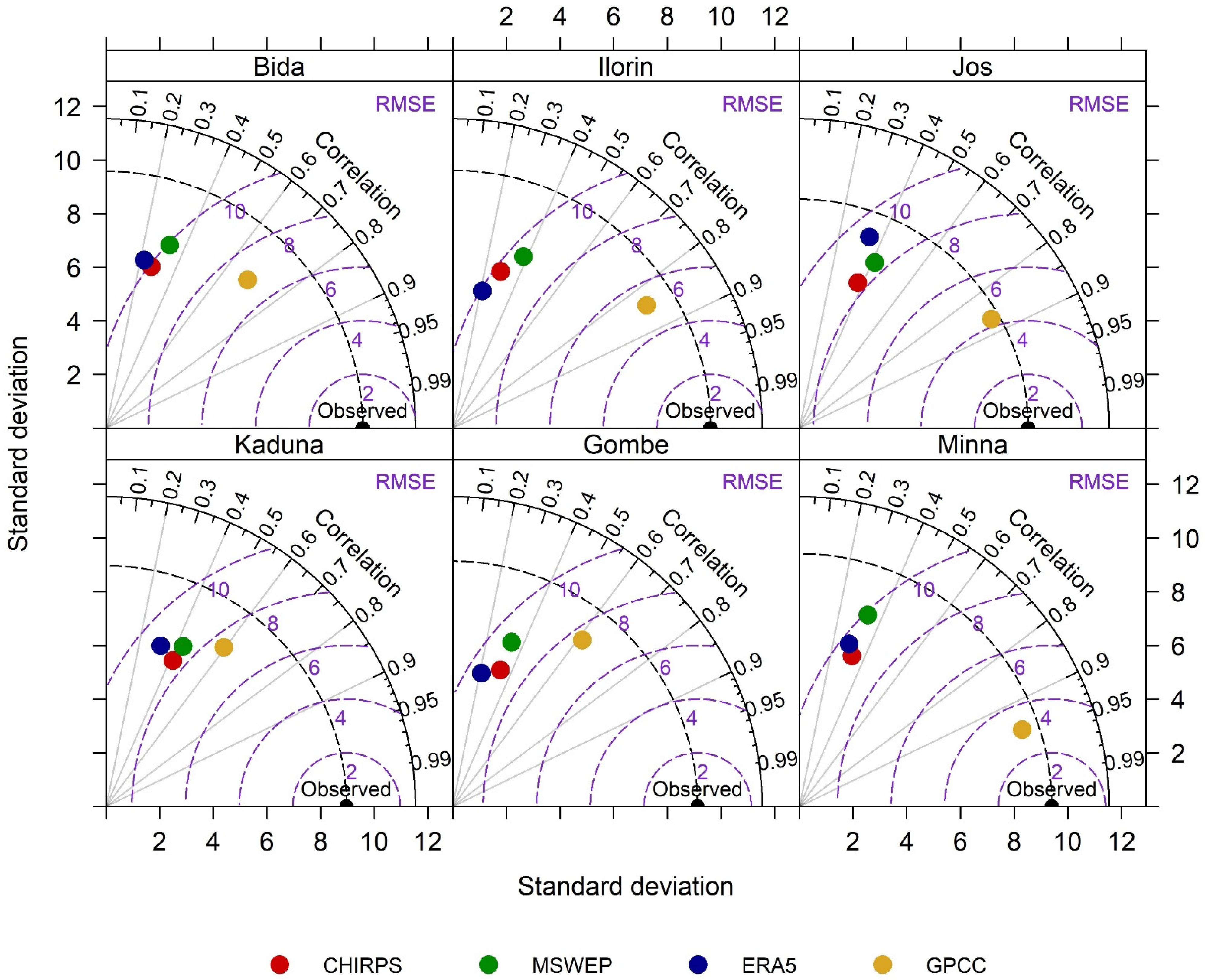
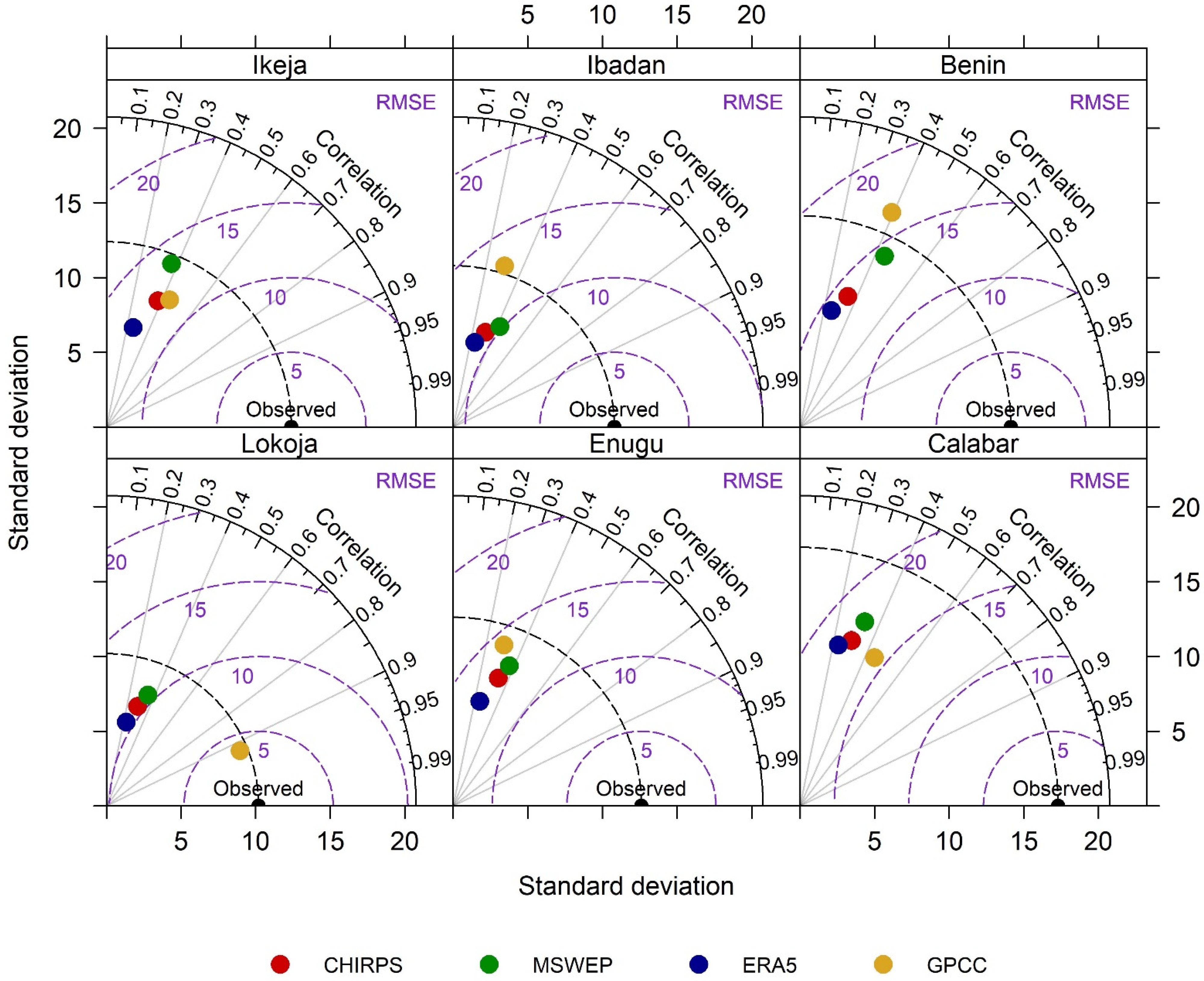
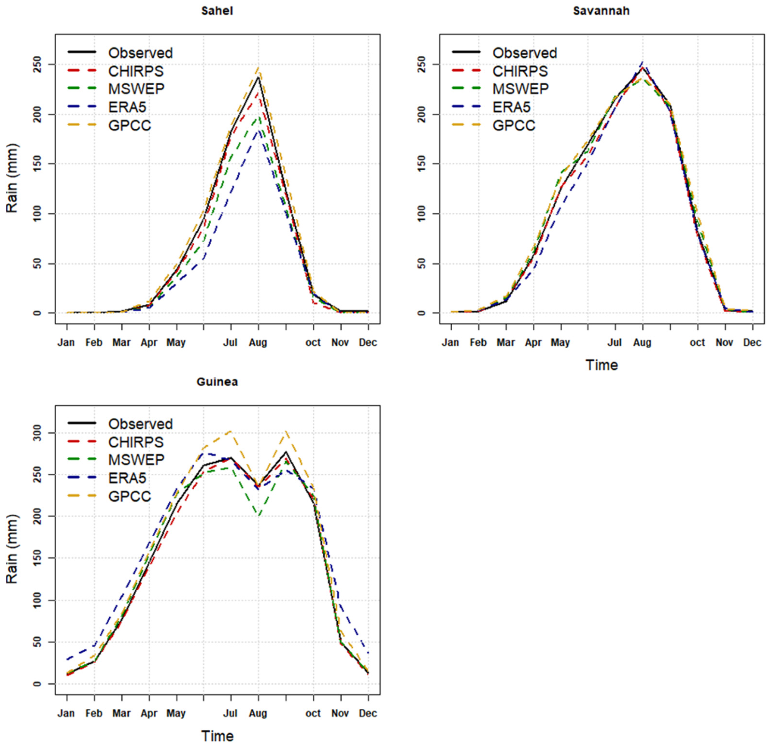
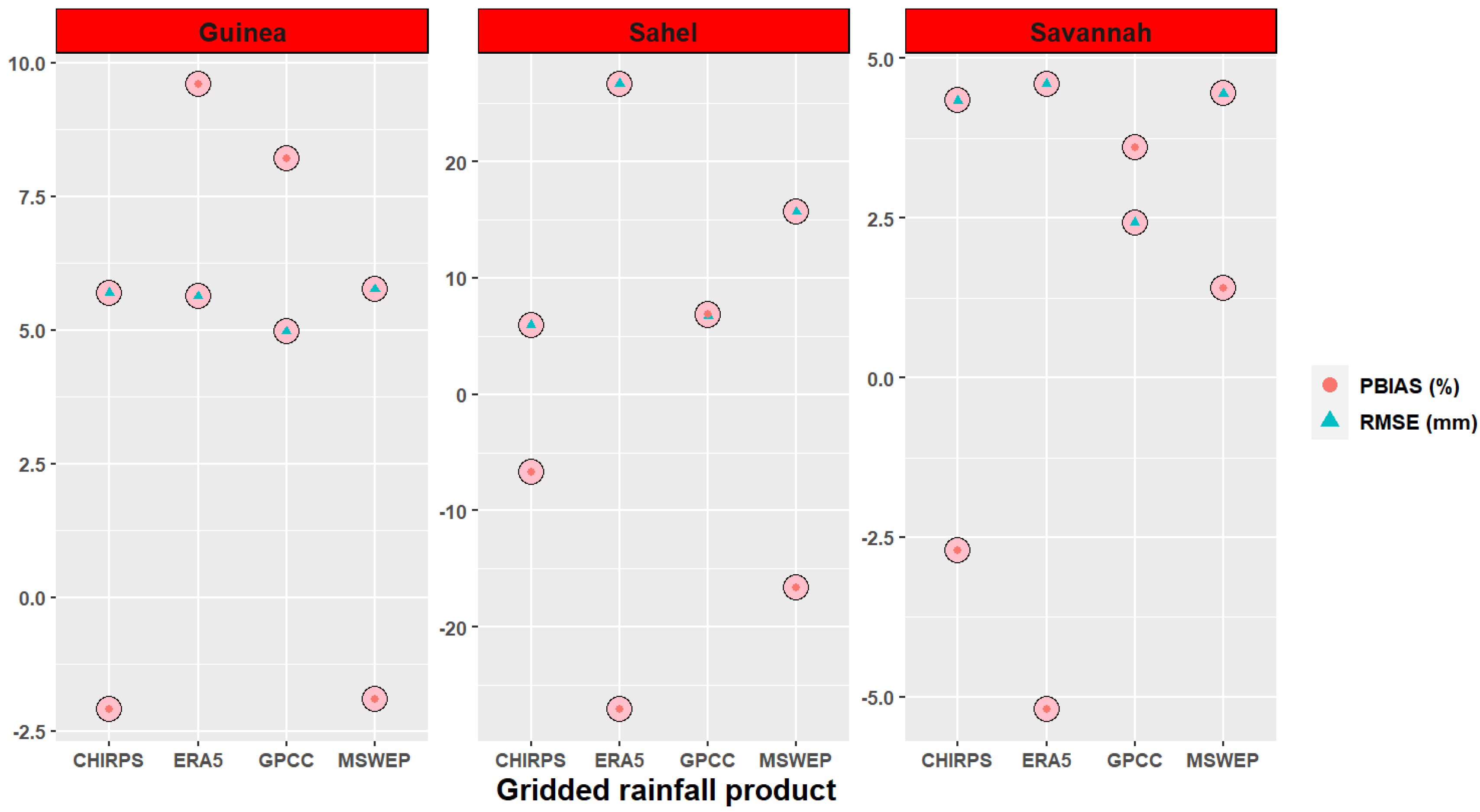
3.1. Gridded Precipitation Rainfall Products Performance
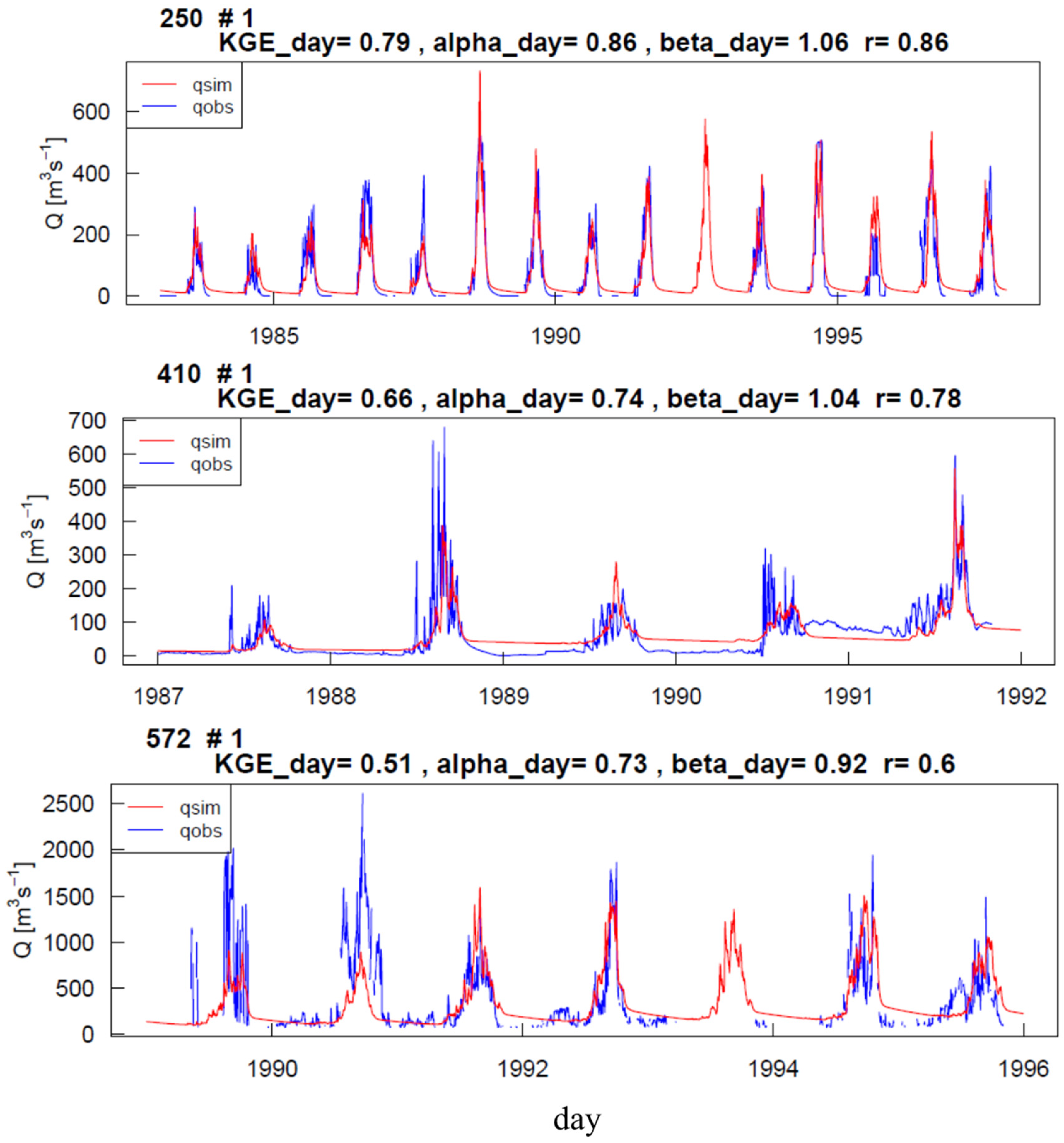
3.2. Exploratory and Optimized Model Results
3.3. Multi-Basin Optimization
4. Conclusions
Author Contributions
Funding
Data Availability Statement
Acknowledgments
Conflicts of Interest
Appendix A

| Parameters | Description | MPR Predictor Variable |
|---|---|---|
| β1 | Thickness of waterfilm on the canopy surface (-) | Landcover |
| β2 | Threshold temperature for temperature for phase transition snow and rain (°C) | - |
| β3 | Degree day factor during rainless days (mm d−1 °C) | Landcover |
| β4 | Rate of increase of the degree-day factor per unit of precipitation (mm d−1 °C) | - |
| β5 | Maximum degree-day factor reached during rainy days (mm d−1 °C) | Landcover |
| β6 | Maximum soil moisture content of kth root zone (mm) | Soil texture, land cover |
| β7 | Parameter that determines the relative contribution of rain or snowmelt to runoff (-) | Soil texture, land cover |
| β8 | Critical value of soil ice content above which the soil is practically impermeable | Soil texture |
| β9 | Shape factor of the gamma distribution (mm) | - |
| β10 | ATI threshold below which unfrozen water content reaches its minimum (K) | Soil texture |
| β11 | ATI threshold above which no frozen water exist (K) | Soil texture |
| β12 | Minimum fraction of unfrozen water content | Soil texture |
| β13 | Weighting multiplier to estimate ATI from air temperature (-) | - |
| β14 | Maximum ponding retention in impervious areas (mm) | Land cover |
| β15 | Permanent wilting point, estimated as a fraction of max. soil moisture content (-) | Soil texture, land cover |
| β16 | Soil moisture limit above which the actual transpiration is equated with the PET (-) | Soil texture, land cover |
| β17 | Fraction of roots in the first root zone layer (-) | Land cover |
| β18 | Maximum holding capacity of the second reservoir (unsaturated zone) (mm) | Soil texture, land cover |
| β19 | Fast-recession constant (d) | Slope |
| β20 | Slow-recession constant (d) | Soil texture |
| β21 | Exponent that quantifies the degree of nonlinearity of the cell response (-) | Soil texture |
| β22 | Effective percolation rate (d) | Soil texture |
| β23 | Baseflow recession rate (d) | Geology |
| β24 | Fraction of the groundwater recharge that might be gained or lost either as deep percolation or as intercatchment groundwater flow in nonconservative catchments (-) | Geology |
| β25 | Duration of the triangular unit hydrograph (h) | Length, slope and landcover along drainage path within cell |
| β26 | Muskingum travel time parameter (h) | Length, slope and landcover of river reach |
| β27 | Muskingum attenuation parameter (-) | Slope of river reach |
| β28 | Aspect correction factor of the PET (-) | Aspect |
Appendix B
| Global Parameter | Basin 250 + basin 410 | Basin 250 + Basin 572 | Basin 572 + Basin 410 |
|---|---|---|---|
| Canopy Interception Factor | 0.2681 | 0.2028 | 0.2156 |
| Organic Matter Content (forest) | 9.8836 | 5.0797 | 6.4115 |
| Organic Matter Content (impervious) | 0.9829 | 0.9182 | 0.8356 |
| Organic Matter Content (pervious) | 4.9552 | 1.0180 | 1.0002 |
| PTF_lower66_5_constant | 0.7997 | 0.7729 | 0.7555 |
| PTF_lower66_5_clay | 0.0012 | 0.0012 | 0.0012 |
| PTF_lower66_5_Db | −0.2504 | −0.2551 | −0.2642 |
| PTF_higher66_5_constant | 0.8001 | 0.8020 | 0.8934 |
| PTF_higher66_5_clay | −0.0011 | −0.0012 | −0.0008 |
| PTF_higher66_5_Db | −0.3496 | −0.3493 | −0.3019 |
| PTF_Ks_constant | −0.4587 | −0.5584 | −0.3396 |
| PTF_Ks_sand | 0.0096 | 0.0199 | 0.0093 |
| PTF_Ks_clay | 0.0078 | 0.0070 | 0.0097 |
| Root Fraction Coefficient (forest) | 0.9021 | 0.9987 | 0.9990 |
| Root Fraction Coefficient (impervious) | 0.92534 | 0.9004 | 0.9497 |
| Root Fraction Coefficient (pervious) | 0.0881 | 0.0011 | 0.0011 |
| Infiltration Shape Factor | 1.0030 | 1.0048 | 1.0080 |
| Impervious Storage Capacity | 0.0888 | 0.0322 | 0.0746 |
| Min Correction Factor PET | 1.1272 | 1.2578 | 1.2655 |
| Max Correction Factor PET | 0.1832 | 0.1988 | 0.1960 |
| Aspect Threshold PET | 198.1908 | 197.6042 | 199.9155 |
| Interflow Storage Capacity Factor | 195.1194 | 194.5852 | 198.6782 |
| Interflow Recession (slope) | 9.9847 | 6.7972 | 2.1313 |
| Fast Interflow Recession (forest) | 2.8495 | 2.8620 | 2.9520 |
| Slow Interflow Recession (Ks) | 5.2018 | 1.2624 | 5.7972 |
| Exponent Slow Interflow | 0.0532 | 0.0532 | 0.0557 |
| Recharge Coefficient | 10.5805 | 22.65960 | 9.6152 |
| Recharge Factor (karstic) | −3.6442 | −4.7927 | −1.2947 |
| Muskingum Travel Time (constant) | 0.3452 | 0.3474 | 0.3487 |
| Muskingum Travel Time (river Length) | 0.0747 | 0.0799 | 0.0798 |
| Muskingum Travel Time (river Slope) | 2.0970 | 2.0374 | 2.0473 |
| Muskingum Travel Time (impervious) | 0.1008 | 0.0970 | 0.1066 |
| Muskingum Attenuation (river Slope) | 0.0101 | 0.0464 | 0.0768 |
| GeoParam(1:) | 993.6726 | 8.4011 | 974.9530 |
| GeoParam(2:) | 997.0097 | 987.2088 | 975.3943 |
References
- Poméon, T.; Diekkrüger, B.; Kumar, R. Computationally Efficient Multivariate Calibration and Validation of a Grid-Based Hydrologic Model in Sparsely Gauged West African River Basins. Water 2018, 10, 1418. [Google Scholar] [CrossRef]
- Bjornlund, V.; Bjornlund, H.; Van Rooyen, A.F. Why Agricultural Production in Sub-Saharan Africa Remains Low Compared to the Rest of the World—A Historical Perspective. Int. J. Water Resour. Dev. 2020, 36, S20–S53. [Google Scholar] [CrossRef]
- Dembélé, M.; Zwart, S.J. Evaluation and Comparison of Satellite-Based Rainfall Products in Burkina Faso, West Africa. Int. J. Remote Sens. 2016, 37, 3995–4014. [Google Scholar] [CrossRef]
- Chapman, S.; E Birch, C.; Pope, E.; Sallu, S.; Bradshaw, C.; Davie, J.; Marsham, J.H. Impact of Climate Change on Crop Suitability in Sub-Saharan Africa in Parameterized and Convection-Permitting Regional Climate Models. Environ. Res. Lett. 2020, 15, 094086. [Google Scholar] [CrossRef]
- Emediegwu, L.E.; Wossink, A.; Hall, A. The Impacts of Climate Change on Agriculture in Sub-Saharan Africa: A Spatial Panel Data Approach. World Dev. 2022, 158, 105967. [Google Scholar] [CrossRef]
- Ofori, S.A.; Cobbina, S.J.; Obiri, S. Climate Change, Land, Water, and Food Security: Perspectives From Sub-Saharan Africa. Front. Sustain. Food Syst. 2021, 5, 218. [Google Scholar] [CrossRef]
- Caldera, H.P.G.M.; Piyathisse, V.R.P.C.; Nandalal, K.D.W. A Comparison of Methods of Estimating Missing Daily Rainfall Data. Eng. J. Inst. Eng. Sri Lanka 2016, 49, 1–8. [Google Scholar] [CrossRef]
- Akinsanola, A.A.; Ajayi, V.O.; Adejare, A.T.; Adeyeri, O.E.; Gbode, I.E.; Ogunjobi, K.O.; Nikulin, G.; Abolude, A.T. Evaluation of Rainfall Simulations over West Africa in Dynamically Downscaled CMIP5 Global Circulation Models. Theor. Appl. Climatol. 2018, 132, 437–450. [Google Scholar] [CrossRef]
- Ogbu, K.N.; Hounguè, N.R.; Gbode, I.E.; Tischbein, B. Performance Evaluation of Satellite-Based Rainfall Products over Nigeria. Climate 2020, 8, 103. [Google Scholar] [CrossRef]
- Hounguè, N.R.; Ogbu, K.N.; Almoradie, A.D.S.; Evers, M. Evaluation of the Performance of Remotely Sensed Rainfall Datasets for Flood Simulation in the Transboundary Mono River Catchment, Togo and Benin. J. Hydrol. Reg. Stud. 2021, 36, 100875. [Google Scholar] [CrossRef]
- Anyadike, R.N.C. Seasonal and Annual Rainfall Variations over Nigeria. Int. J. Climatol. 1993, 13, 567–580. [Google Scholar] [CrossRef]
- Animashaun, I.M.; Oguntunde, P.G.; Akinwumiju, A.S.; Olubanjo, O.O. Rainfall Analysis over the Niger Central Hydrological Area, Nigeria: Variability, Trend, and Change Point Detection. Sci. Afr. 2020, 8, e00419. [Google Scholar] [CrossRef]
- Okafor, G.C.; Ogbu, K.N. Assessment of the Impact of Climate Change on the Freshwater Availability of Kaduna River Basin, Nigeria. J. Water Land Dev. 2018, 38, 105–114. [Google Scholar] [CrossRef]
- Usman, M.; Nichol, J.E.; Ibrahim, A.T.; Buba, L.F. A Spatio-Temporal Analysis of Trends in Rainfall from Long Term Satellite Rainfall Products in the Sudano Sahelian Zone of Nigeria. Agric. For. Meteorol. 2018, 260–261, 273–286. [Google Scholar] [CrossRef]
- Akande, A.; Costa, A.C.; Mateu, J.; Henriques, R. Geospatial Analysis of Extreme Weather Events in Nigeria (1985–2015) Using Self-Organizing Maps. Adv. Meteorol. 2017, 2017, 8576150. [Google Scholar] [CrossRef]
- Adeyeri, O.E.; Lawin, A.E.; Laux, P.; Ishola, K.A.; Ige, S.O. Analysis of Climate Extreme Indices over the Komadugu-Yobe Basin, Lake Chad Region: Past and Future Occurrences. Weather. Clim. Extrem. 2019, 23. [Google Scholar] [CrossRef]
- Ngene, B.U.; Nwafor, C.O.; Bamigboye, G.O.; Ogbiye, A.S.; Ogundare, J.O.; Akpan, V.E. Assessment of Water Resources Development and Exploitation in Nigeria: A Review of Integrated Water Resources Management Approach. Heliyon 2021, 7, 1–10. [Google Scholar] [CrossRef]
- Ezenwaji, E.E.; Eduputa, B.M.; Ogbuozobe, J.E. Employing Water Demand Management Option for the Improvement of Water Supply and Sanitation in Nigeria. J. Water Resour. Prot. 2015, 7, 624–635. [Google Scholar] [CrossRef]
- Shiru, M.S.; Shahid, S.; Park, I. Projection of Water Availability and Sustainability in Nigeria Due to Climate Change. Sustainability 2021, 13, 6284. [Google Scholar] [CrossRef]
- Dembélé, M.; Schaefli, B.; Van De Giesen, N.; Mariéthoz, G. Suitability of 17 Gridded Rainfall and Temperature Datasets for Large-Scale Hydrological Modelling in West Africa. Hydrol. Earth Syst. Sci 2020, 24, 5379–5406. [Google Scholar] [CrossRef]
- Camici, S.; Massari, C.; Ciabatta, L.; Marchesini, I.; Brocca, L. Which Rainfall Score Is More Informative about the Performance in River Discharge Simulation? A Comprehensive Assessment on 1318 Basins over Europe. Hydrol. Earth Syst. Sci. 2020, 24, 4869–4885. [Google Scholar] [CrossRef]
- Trinh-Tuan, L.; Matsumoto, J.; Ngo-Duc, T.; Nodzu, M.I.; Inoue, T. Evaluation of Satellite Precipitation Products over Central Vietnam. Prog. Earth Planet. Sci. 2019, 6, 54. [Google Scholar] [CrossRef]
- Mbaye, M.L.; Haensler, A.; Hagemann, S.; Gaye, A.T.; Moseley, C.; Afouda, A. Impact of Statistical Bias Correction on the Projected Climate Change Signals of the Regional Climate Model REMO over the Senegal River Basin. Int. J. Climatol. 2016, 36, 2035–2049. [Google Scholar] [CrossRef]
- Camberlin, P.; Barraud, G.; Bigot, S.; Dewitte, O.; Makanzu Imwangana, F.; Maki Mateso, J.; Martiny, N.; Monsieurs, E.; Moron, V.; Pellarin, T.; et al. Evaluation of Remotely Sensed Rainfall Products over Central Africa. Q. J. R. Meteorol. Soc. 2019, 145, 2115–2138. [Google Scholar] [CrossRef]
- Raimonet, M.; Oudin, L.; Thieu, V.; Silvestre, M.; Vautard, R.; Rabouille, C.; Le Moigne, P. Evaluation of Gridded Meteorological Datasets for Hydrological Modeling. J. Hydrometeorol. 2017, 18, 3027–3041. [Google Scholar] [CrossRef]
- Hassan, I.; Kalin, R.M.; White, C.J.; Aladejana, J.A. Evaluation of Daily Gridded Meteorological Datasets over the Niger Delta Region of Nigeria and Implication to Water Resources Management. Atmos. Clim. Sci. 2020, 10, 21–39. [Google Scholar] [CrossRef]
- Contractor, S.; Alexander, L.V.; Donat, M.G.; Herold, N. How Well Do Gridded Datasets of Observed Daily Precipitation Compare over Australia? Adv. Meteorol. 2015, 2015, 325718. [Google Scholar] [CrossRef]
- Nhi, P.T.T.; Khoi, D.N.; Hoan, N.X. Evaluation of Five Gridded Rainfall Datasets in Simulating Streamflow in the Upper Dong Nai River Basin, Vietnam. Int. J. Digit. Earth 2019, 12, 311–327. [Google Scholar] [CrossRef]
- Sun, Q.; Miao, C.; Duan, Q.; Ashouri, H.; Sorooshian, S.; Hsu, K. A Review of Global Precipitation Data Sets: Data Sources, Estimation, and Intercomparisons. Rev. Geophys. 2018, 56, 79–107. [Google Scholar] [CrossRef]
- Dinku, T.; Funk, C.; Peterson, P.; Maidment, R.; Tadesse, T.; Gadain, H.; Ceccato, P. Validation of the CHIRPS Satellite Rainfall Estimates over Eastern Africa. Q. J. R. Meteorol. Soc. 2018, 144, 292–312. [Google Scholar] [CrossRef]
- Hersbach, H.; Bell, B.; Berrisford, P.; Hirahara, S.; Horányi, A.; Muñoz-Sabater, J.; Nicolas, J.; Peubey, C.; Radu, R.; Schepers, D.; et al. The ERA5 Global Reanalysis. Q. J. R. Meteorol. Soc. 2020, 146, 1999–2049. [Google Scholar] [CrossRef]
- Bitew, M.M.; Gebremichael, M. Evaluation of Satellite Rainfall Products through Hydrologic Simulation in a Fully Distributed Hydrologic Model. Water Resour. Res. 2011, 47, 1–11. [Google Scholar] [CrossRef]
- Samaniego, L.; Kumar, R.; Jackisch, C. Predictions in a Data-Sparse Region Using a Regionalized Grid-Based Hydrologic Model Driven by Remotely Sensed Data. Hydrol. Res. 2011, 42, 338–355. [Google Scholar] [CrossRef]
- Schuol, J.; Abbaspour, K.C.; Srinivasan, R.; Yang, H. Estimation of Freshwater Availability in the West African Sub-Continent Using the SWAT Hydrologic Model. J. Hydrol. 2008, 352, 30–49. [Google Scholar] [CrossRef]
- Poméon, T.; Diekkrüger, B.; Springer, A.; Kusche, J.; Eicker, A. Multi-Objective Validation of SWAT for Sparsely-GaugedWest African River Basins - A Remote Sensing Approach. Water 2018, 10, 451. [Google Scholar] [CrossRef]
- Xie, H.; Longuevergne, L.; Ringler, C.; Scanlon, B.R. Calibration and Evaluation of a Semi-Distributed Watershed Model of Sub-Saharan Africa Using GRACE Data. Hydrol. Earth Syst. Sci. 2012, 16, 3083–3099. [Google Scholar] [CrossRef]
- Fujihara, Y.; Yamamoto, Y.; Tsujimoto, Y.; Sakagami, J.-I. Discharge Simulation in a Data-Scarce Basin Using Reanalysis and Global Precipitation Data: A Case Study of the White Volta Basin. J. Water Resour. Prot. 2014, 06, 1316–1325. [Google Scholar] [CrossRef]
- Poméon, T.; Jackisch, D.; Diekkrüger, B. Evaluating the Performance of Remotely Sensed and Reanalysed Precipitation Data over West Africa Using HBV Light. J. Hydrol. 2017, 547, 222–235. [Google Scholar] [CrossRef]
- Samaniego, L.; Kumar, R.; Attinger, S. Multiscale Parameter Regionalization of a Grid-Based Hydrologic Model at the Mesoscale. Water Resour. Res. 2010, 46, 1–25. [Google Scholar] [CrossRef]
- Tegegne, G.; Park, D.K.; Kim, Y.O. Comparison of Hydrological Models for the Assessment of Water Resources in a Data-Scarce Region, the Upper Blue Nile River Basin. J. Hydrol. Reg. Stud. 2017, 14, 49–66. [Google Scholar] [CrossRef]
- Beven, K. How Far Can We Go in Distributed Hydrological Modelling? Hydrol. Earth Syst. Sci. 2001, 5, 1–12. [Google Scholar] [CrossRef]
- Beven, K. Towards a Coherent Philosophy for Modelling the Environment. Proc. R. Soc. Lond. Ser. A Math. Phys. Eng. Sci. 2002, 454, 2465–2484. [Google Scholar] [CrossRef]
- Schoups, G.; Van De Giesen, N.C.; Savenije, H.H.G. Model Complexity Control for Hydrologic Prediction. Water Resour. Res. 2008, 44, 1–14. [Google Scholar] [CrossRef]
- Kumar, R.; Samaniego, L.; Attinger, S. Implications of Distributed Hydrologic Model Parameterization on Water Fluxes at Multiple Scales and Locations. Water Resour. Res. 2013, 49, 360–379. [Google Scholar] [CrossRef]
- Ocio, D.; Beskeen, T.; Smart, K. Fully Distributed Hydrological Modelling for Catchmentwide Hydrological Data Verification. Hydrol. Res. 2019, 50, 1520–1534. [Google Scholar] [CrossRef]
- Hrachowitz, M.; Savenije, H.H.G.; Blöschl, G.; McDonnell, J.J.; Sivapalan, M.; Pomeroy, J.W.; Arheimer, B.; Blume, T.; Clark, M.P.; Ehret, U.; et al. A Decade of Predictions in Ungauged Basins (PUB)—A Review. Hydrol. Sci. J. 2013, 58, 1198–1255. [Google Scholar] [CrossRef]
- Golian, S.; Murphy, C.; Meresa, H. Regionalization of Hydrological Models for Flow Estimation in Ungauged Catchments in Ireland. J. Hydrol. Reg. Stud. 2021, 36, 100859. [Google Scholar] [CrossRef]
- Arnold, J.G.; Srinivasan, R.; Muttiah, R.S.; Williams, J.R. LARGE AREA HYDROLOGIC MODELING AND ASSESSMENT PART I: MODEL DEVELOPMENT. J. Am. Water Resour. Assoc. 1998, 34, 73–89. [Google Scholar] [CrossRef]
- Ndulue, E.L.; Ezenne, G.I.; Mbajiorgu, C.C.; Ogwo, V.; Ogbu, K.N. Hydrological Modelling of Upper Ebonyi Watershed Using the SWAT Model. Int. J. Hydrol. Sci. Technol. 2018, 8, 120–133. [Google Scholar] [CrossRef]
- Odusanya, A.E.; Mehdi, B.; Schürz, C.; Oke, A.O.; Awokola, O.S.; Awomeso, J.A.; Adejuwon, J.O.; Schulz, K. Multi-Site Calibration and Validation of SWAT with Satellite-Based Evapotranspiration in a Data-Sparse Catchment in Southwestern Nigeria. Hydrol. Earth Syst. Sci. 2019, 23, 1113–1144. [Google Scholar] [CrossRef]
- Rathjens, H.; Bieger, K.; Srinivasan, R.; Arnold, J.G. CMhyd User Manual Documentation for Preparing Simulated Climate Change Data for Hydrologic Impact Studies. 2016, p. 16. Available online: https://swat.tamu.edu/media/115265/bias_cor_man.pdf (accessed on 25 August 2020).
- Guug, S.S.; Abdul-Ganiyu, S.; Kasei, R.A. Application of SWAT Hydrological Model for Assessing Water Availability at the Sherigu Catchment of Ghana and Southern Burkina Faso. HydroResearch 2020, 3, 124–133. [Google Scholar] [CrossRef]
- Zettam, A.; Taleb, A.; Sauvage, S.; Boithias, L.; Belaidi, N.; Sanchez-Perez, J.M. Applications of a SWAT Model to Evaluate the Contribution of the Tafna Catchment (North-West Africa) to the Nitrate Load Entering the Mediterranean Sea. Environ. Monit. Assess. 2020, 192, 510. [Google Scholar] [CrossRef]
- Bizuneh, B.B.; Moges, M.A.; Sinshaw, B.G.; Kerebih, M.S. SWAT and HBV Models’ Response to Streamflow Estimation in the Upper Blue Nile Basin, Ethiopia. Water-Energy Nexus 2021, 4, 41–53. [Google Scholar] [CrossRef]
- Hundecha, Y.; Bárdossy, A. Modeling of the Effect of Land Use Changes on the Runoff Generation of a River Basin through Parameter Regionalization of a Watershed Model. J. Hydrol. 2004, 292, 281–295. [Google Scholar] [CrossRef]
- Rakovec, O.; Kumar, R.; Attinger, S.; Samaniego, L. Improving the Realism of Hydrologic Model Functioning through Multivariate Parameter Estimation. Water Resour. Res. 2016, 52, 7779–7792. [Google Scholar] [CrossRef]
- Zink, M.; Kumar, R.; Cuntz, M.; Samaniego, L. A High-Resolution Dataset of Water Fluxes and States for Germany Accounting for Parametric Uncertainty. Hydrol. Earth Syst. Sci. 2017, 21, 1769–1790. [Google Scholar] [CrossRef]
- Samaniego, L.; Thober, S.; Wanders, N.; Pan, M.; Rakovec, O.; Sheffield, J.; Wood, E.F.; Prudhomme, C.; Rees, G.; Houghton-Carr, H.; et al. Hydrological Forecasts and Projections for Improved Decision-Making in the Water Sector in Europe. Bull. Am. Meteorol. Soc. 2019, 100, 2451–2471. [Google Scholar] [CrossRef]
- Rakovec, O.; Mizukami, N.; Kumar, R.; Newman, A.J.; Thober, S.; Wood, A.W.; Clark, M.P.; Samaniego, L. Diagnostic Evaluation of Large-Domain Hydrologic Models Calibrated Across the Contiguous United States. J. Geophys. Res. Atmos. 2019, 124, 13991–14007. [Google Scholar] [CrossRef]
- Saha, T.R.; Shrestha, P.K.; Rakovec, O.; Thober, S.; Samaniego, L. A Drought Monitoring Tool for South Asia. Environ. Res. Lett. 2021, 16, 054014. [Google Scholar] [CrossRef]
- Dembélé, M.; Hrachowitz, M.; Savenije, H.H.G.; Mariéthoz, G.; Schaefli, B. Improving the Predictive Skill of a Distributed Hydrological Model by Calibration on Spatial Patterns With Multiple Satellite Data Sets. Water Resour. Res. 2020, 56. [Google Scholar] [CrossRef]
- Dembélé, M.; Vrac, M.; Ceperley, N.; Zwart, S.; Larsen, J.; Dadson, S.; Mariéthoz, G.; Schaefli, B. Contrasting Dynamics of Hydrological Processes in the Volta River Basin under Global Warming. Hydrol. Earth Syst. Sci. Discuss. 2022, 26, 1481–1506. [Google Scholar] [CrossRef]
- Omotosho, J.B.; Abiodun, B.J. A Numerical Study of Moisture Build-up and Rainfall over West Africa. Meteorol. Appl. 2007, 14, 209–225. [Google Scholar] [CrossRef]
- Gbode, I.E.; Adeyeri, O.E.; Menang, K.P.; Intsiful, J.D.K.; Ajayi, V.O.; Omotosho, J.A.; Akinsanola, A.A. Observed Changes in Climate Extremes in Nigeria. Meteorol. Appl. 2019, 26, 642–654. [Google Scholar] [CrossRef]
- Odunuga, S.; Okeke, I.; Omojola, A.; Oyebande, L. Hydro-Climatic Variability of the Hadejia-Jama’are River Systems in North-Central Nigeria. IAHS-AISH Publication 2011, 344, 163–168. [Google Scholar]
- U.S Geological Survey USGS EROS Archive—Digital Elevation—Global Multi-Resolution Terrain Elevation Data 2010 (GMTED2010)|U.S. Geological Survey. Available online: https://www.usgs.gov/centers/eros/science/usgs-eros-archive-digital-elevation-global-multi-resolution-terrain-elevation (accessed on 25 August 2020).
- Lindström, G.; Johansson, B.; Persson, M.; Gardelin, M.; Bergström, S. Development and Test of the Distributed HBV-96 Hydrological Model. J. Hydrol. 1997, 201, 272–288. [Google Scholar] [CrossRef]
- Liang, X.; Lettenmaier, D.P.; Wood, E.F.; Burges, S.J. A Simple Hydrologically Based Model of Land Surface Water and Energy Fluxes for General Circulation Models. J. Geophys. Res. Atmos. 1994, 99, 14415–14428. [Google Scholar] [CrossRef]
- Kumar, R.; Samaniego, L.; Attinger, S. The Effects of Spatial Discretization and Model Parameterization on the Prediction of Extreme Runoff Characteristics. J. Hydrol. 2010, 392, 54–69. [Google Scholar] [CrossRef]
- Schweppe, R.; Thober, S.; Müller, S.; Kelbling, M.; Kumar, R.; Attinger, S.; Samaniego, L. MPR 1.0: A Stand-Alone Multiscale Parameter Regionalization Tool for Improved Parameter Estimation of Land Surface Models. Geosci. Model. Dev. 2022, 15, 859–882. [Google Scholar] [CrossRef]
- Samaniego, L.; Kumar, R.; Thober, S.; Rakovec, O.; Zink, M.; Wanders, N.; Eisner, S.; Müller Schmied, H.; Sutanudjaja, E.; Warrach-Sagi, K.; et al. Toward Seamless Hydrologic Predictions across Spatial Scales. Hydrol. Earth Syst. Sci. 2017, 21, 4323–4346. [Google Scholar] [CrossRef]
- Mizukami, N.; Clark, M.P.; Newman, A.J.; Wood, A.W.; Gutmann, E.D.; Nijssen, B.; Rakovec, O.; Samaniego, L. Towards Seamless Large-Domain Parameter Estimation for Hydrologic Models. Water Resour. Res. 2017, 53, 8020–8040. [Google Scholar] [CrossRef]
- Imhoff, R.O.; van Verseveld, W.J.; van Osnabrugge, B.; Weerts, A.H. Scaling Point-Scale (Pedo)Transfer Functions to Seamless Large-Domain Parameter Estimates for High-Resolution Distributed Hydrologic Modeling: An Example for the Rhine River. Water Resour. Res. 2020, 56, e2019WR026807. [Google Scholar] [CrossRef]
- Hartmann, J.; Moosdorf, N. The New Global Lithological Map Database GLiM: A Representation of Rock Properties at the Earth Surface. Geochem. Geophys. Geosystems 2012, 13, 1–37. [Google Scholar] [CrossRef]
- Hengl, T.; Mendes de Jesus, J.; Heuvelink, G.B.M.; Ruiperez Gonzalez, M.; Kilibarda, M.; Blagotić, A.; Shangguan, W.; Wright, M.N.; Geng, X.; Bauer-Marschallinger, B.; et al. SoilGrids250m: Global Gridded Soil Information Based on Machine Learning. PLOS ONE 2017, 12, e0169748. [Google Scholar] [CrossRef]
- Bontemps, S.; Herold, M.; Kooistra, L.; Van Groenestijn, A.; Hartley, A.; Arino, O.; Moreau, I.; Defourny, P. Global Land Cover Dataset for Climate Models Revisiting Land Cover Observations to Address the Needs of the Climate Modelling Community Global Land Cover Dataset for Climate Models. Biogeosciences Discuss 2011, 8, 7713–7740. [Google Scholar] [CrossRef]
- Zhu, Z.; Bi, J.; Pan, Y.; Ganguly, S.; Anav, A.; Xu, L.; Samanta, A.; Piao, S.; Nemani, R.R.; Myneni, R.B. Global Data Sets of Vegetation Leaf Area Index (LAI)3g and Fraction of Photosynthetically Active Radiation (FPAR)3g Derived from Global Inventory Modeling and Mapping Studies (GIMMS) Normalized Difference Vegetation Index (NDVI3G) for the Period 1981 to 2011. Remote Sens. 2013, 5, 927–948. [Google Scholar] [CrossRef]
- Funk, C.; Peterson, P.; Landsfeld, M.; Pedreros, D.; Verdin, J.; Shukla, S.; Husak, G.; Rowland, J.; Harrison, L.; Hoell, A.; et al. The Climate Hazards Infrared Precipitation with Stations —A New Environmental Record for Monitoring Extremes. Sci. Data. 2015, 2. [Google Scholar] [CrossRef]
- Schamm, K.; Ziese, M.; Becker, A.; Finger, P.; Meyer-Christoffer, A.; Schneider, U.; Schröder, M.; Stender, P. Global Gridded Precipitation over Land: A Description of the New GPCC First Guess Daily Product. Earth Syst. Sci. Data 2014, 6, 49–60. [Google Scholar] [CrossRef]
- Beck, H.E.; Wood, E.F.; Pan, M.; Fisher, C.K.; Miralles, D.G.; Van Dijk, A.I.J.M.; McVicar, T.R.; Adler, R.F. MSWEP V2 Global 3-Hourly 0.1° Precipitation: Methodology and Quantitative Assessment. Bull. Am. Meteorol. Soc. 2019, 100, 473–500. [Google Scholar] [CrossRef]
- Gupta, H.V.; Kling, H.; Yilmaz, K.K.; Martinez, G.F. Decomposition of the Mean Squared Error and NSE Performance Criteria: Implications for Improving Hydrological Modelling. J. Hydrol. 2009, 377, 80–91. [Google Scholar] [CrossRef]
- Moriasi, D.N.; Gitau, M.W.; Pai, N.; Daggupati, P.; Gitau, M.W.; Member, A.; Moriasi, D.N. Hydrologic and water quality models: Performance measures and evaluation criteria. Trans. ASABE 2015, 58, 1763–1785. [Google Scholar] [CrossRef]
- Hargreaves, G.H.; Samani, Z.A. Reference Crop Evapotranspiration from Temperature. Appl. Eng. Agric. 1985, 1, 96–99. [Google Scholar] [CrossRef]
- Knoben, W.J.M.; Freer, J.E.; Woods, R.A. Technical Note: Inherent Benchmark or Not? Comparing Nash-Sutcliffe and Kling-Gupta Efficiency Scores. Hydrol. Earth Syst. Sci. 2019, 23, 4323–4331. [Google Scholar] [CrossRef]
- Duan, Q.Y.; Gupta, V.K.; Sorooshian, S. Shuffled Complex Evolution Approach for Effective and Efficient Global Minimization. J. Optim. Theory Appl. 1993, 76, 501–521. [Google Scholar] [CrossRef]
- Ingber, L. Simulated Annealing: Practice versus Theory. Math. Comput. Model. 1993, 18, 29–57. [Google Scholar] [CrossRef]
- Eberhart, R.; Kennedy, J. New Optimizer Using Particle Swarm Theory. In Proceedings of the Sixth International Symposium on Micro Machine and Human Science, Nagoya, Japan, 4–6 October 1995; pp. 39–43. [Google Scholar]
- Hansen, N. The CMA Evolution Strategy: A Comparing Review. In Towards a New Evolutionary Computation; Springer: Berlin/Heidelberg, Germany, 2007; pp. 75–102. [Google Scholar]
- Tolson, B.A.; Shoemaker, C.A. Dynamically Dimensioned Search Algorithm for Computationally Efficient Watershed Model Calibration. Water Resour. Res. 2007, 43, 1–16. [Google Scholar] [CrossRef]
- Salaudeen, A.; Ismail, A.; Adeogun, B.K.; Ajibike, M.A.; Zubairu, I. Evaluation of Ground-Based, Daily, Gridded Precipitation Products for Upper Benue River Basin, Nigeria. Eng. Appl. Sci. Res. 2021, 48, 397–405. [Google Scholar] [CrossRef]
- Ogunjo, S.T.; Olusegun, C.F.; Fuwape, I.A. Evaluation of Monthly Precipitation Data from Three Gridded Climate Data Products over Nigeria. Remote Sens. Earth Syst. Sci. 2022, 5, 119–128. [Google Scholar] [CrossRef]
- Zandler, H.; Haag, I.; Samimi, C. Evaluation Needs and Temporal Performance Differences of Gridded Precipitation Products in Peripheral Mountain Regions. Sci. Rep. 2019, 9, 15118. [Google Scholar] [CrossRef]
- Akinyemi, D.F.; Ayanlade, O.S.; Nwaezeigwe, J.O.; Ayanlade, A. A Comparison of the Accuracy of Multi-Satellite Precipitation Estimation and Ground Meteorological Records Over Southwestern Nigeria. Remote Sens. Earth Syst. Sci. 2020, 3, 1–12. [Google Scholar] [CrossRef]
- Satgé, F.; Ruelland, D.; Bonnet, M.-P.; Molina, J.; Pillco, R. Consistency of Satellite-Based Precipitation Products in Space and over Time Compared with Gauge Observations and Snow- Hydrological Modelling in the Lake Titicaca Region. Hydrol. Earth Syst. Sci. 2019, 23, 595–619. [Google Scholar] [CrossRef]
- Satgé, F.; Defrance, D.; Sultan, B.; Bonnet, M.P.; Seyler, F.; Rouché, N.; Pierron, F.; Paturel, J.E. Evaluation of 23 Gridded Precipitation Datasets across West Africa. J. Hydrol. 2020, 581, 124412. [Google Scholar] [CrossRef]
- Beck, H.E.; Vergopolan, N.; Pan, M.; Levizzani, V.; Van Dijk, A.I.J.M.; Weedon, G.P.; Brocca, L.; Pappenberger, F.; Huffman, G.J.; Wood, E.F. Global-Scale Evaluation of 22 Precipitation Datasets Using Gauge Observations and Hydrological Modeling. Hydrol. Earth Syst. Sci. 2017, 21, 6201–6217. [Google Scholar] [CrossRef]
- Zelelew, M.B.; Alfredsen, K. Transferability of Hydrological Model Parameter Spaces in the Estimation of Runoff in Ungauged Catchments. Hydrol. Sci. J. 2014, 59, 1470–1490. [Google Scholar] [CrossRef][Green Version]


| Precipitation Product | Data Sources | Spatial Coverage | Spatial Resolution |
|---|---|---|---|
| ERA5 | Reanalysis | Global | 0.25° |
| CHIRPS | Satellite, gauge, reanalysis | 50° N–50° S | 0.05° |
| GPCC | Gauge | 90° N–90° S | 1.0° |
| MSWEPv2.2 | Satellite, gauge, reanalysis | Global | 0.1° |
| Basin Name | GRDC Station No | Period of Coverage | Station Name | Source |
|---|---|---|---|---|
| Jamaare | 1837250 (250) | 1983–1997 | Kotagum | GRDC |
| Hadejia | 1837410 (410) | 1987–1991 | Wudil | GRDC |
| Kaduna * | 572 | 1989–1995 | Wuya | NHISA, Nigeria |
| Simulation Using Default mHM Parameters | Simulation Using Optimized mHM Parameters | Forcing | ||||
|---|---|---|---|---|---|---|
| Jamaare (Basin 250) | Hadejia (Basin 410) | Kaduna (Basin 572) | Jamaare (Basin 250) | Hadejia (Basin 410) | Kaduna (Basin 572) | |
| 0.68 | −1.18 | −2.22 | 0.79 | 0.66 | 0.51 | CHIRPS |
| 0.06 | 0.68 | −1.78 | 0.75 | 0.64 | 0.44 | ERA5 |
| 0.65 | −0.53 | −1.78 | 0.76 | 0.74 | 0.52 | MSWEP |
| 0.43 | −1.34 | −1.50 | 0.45 | 0.63 | 0.49 | GPCC |
| Basin | Multi-Basin Combinations | Meteo | ||
|---|---|---|---|---|
| Basin 250 + Basin 410 | Basin 572 + Basin 410 | Basin 250 + Basin 572 | CHIRPS | |
| 1 | 0.33 | 0.51 | −0.03 | |
| 2 | 0.64 | 0.51 | 0.58 | |
| Metric | Single Basin mHM Simulation | Meteo | ||
|---|---|---|---|---|
| Basin 572 | Basin 250 | Basin 410 | CHIRPS | |
| KGE | 0.02 | −0.12 | 0.54 | |
Publisher’s Note: MDPI stays neutral with regard to jurisdictional claims in published maps and institutional affiliations. |
© 2022 by the authors. Licensee MDPI, Basel, Switzerland. This article is an open access article distributed under the terms and conditions of the Creative Commons Attribution (CC BY) license (https://creativecommons.org/licenses/by/4.0/).
Share and Cite
Ogbu, K.N.; Rakovec, O.; Shrestha, P.K.; Samaniego, L.; Tischbein, B.; Meresa, H. Testing the mHM-MPR Reliability for Parameter Transferability across Locations in North–Central Nigeria. Hydrology 2022, 9, 158. https://doi.org/10.3390/hydrology9090158
Ogbu KN, Rakovec O, Shrestha PK, Samaniego L, Tischbein B, Meresa H. Testing the mHM-MPR Reliability for Parameter Transferability across Locations in North–Central Nigeria. Hydrology. 2022; 9(9):158. https://doi.org/10.3390/hydrology9090158
Chicago/Turabian StyleOgbu, Kingsley Nnaemeka, Oldrich Rakovec, Pallav Kumar Shrestha, Luis Samaniego, Bernhard Tischbein, and Hadush Meresa. 2022. "Testing the mHM-MPR Reliability for Parameter Transferability across Locations in North–Central Nigeria" Hydrology 9, no. 9: 158. https://doi.org/10.3390/hydrology9090158
APA StyleOgbu, K. N., Rakovec, O., Shrestha, P. K., Samaniego, L., Tischbein, B., & Meresa, H. (2022). Testing the mHM-MPR Reliability for Parameter Transferability across Locations in North–Central Nigeria. Hydrology, 9(9), 158. https://doi.org/10.3390/hydrology9090158