
Land Use Affects Soil Water Balance and Soil Desiccation within the Soil Profile: Evidence from the Western Loess Plateau Case

 , ,
, ,
Abstract
:1. Introduction
2. Materials and Methods
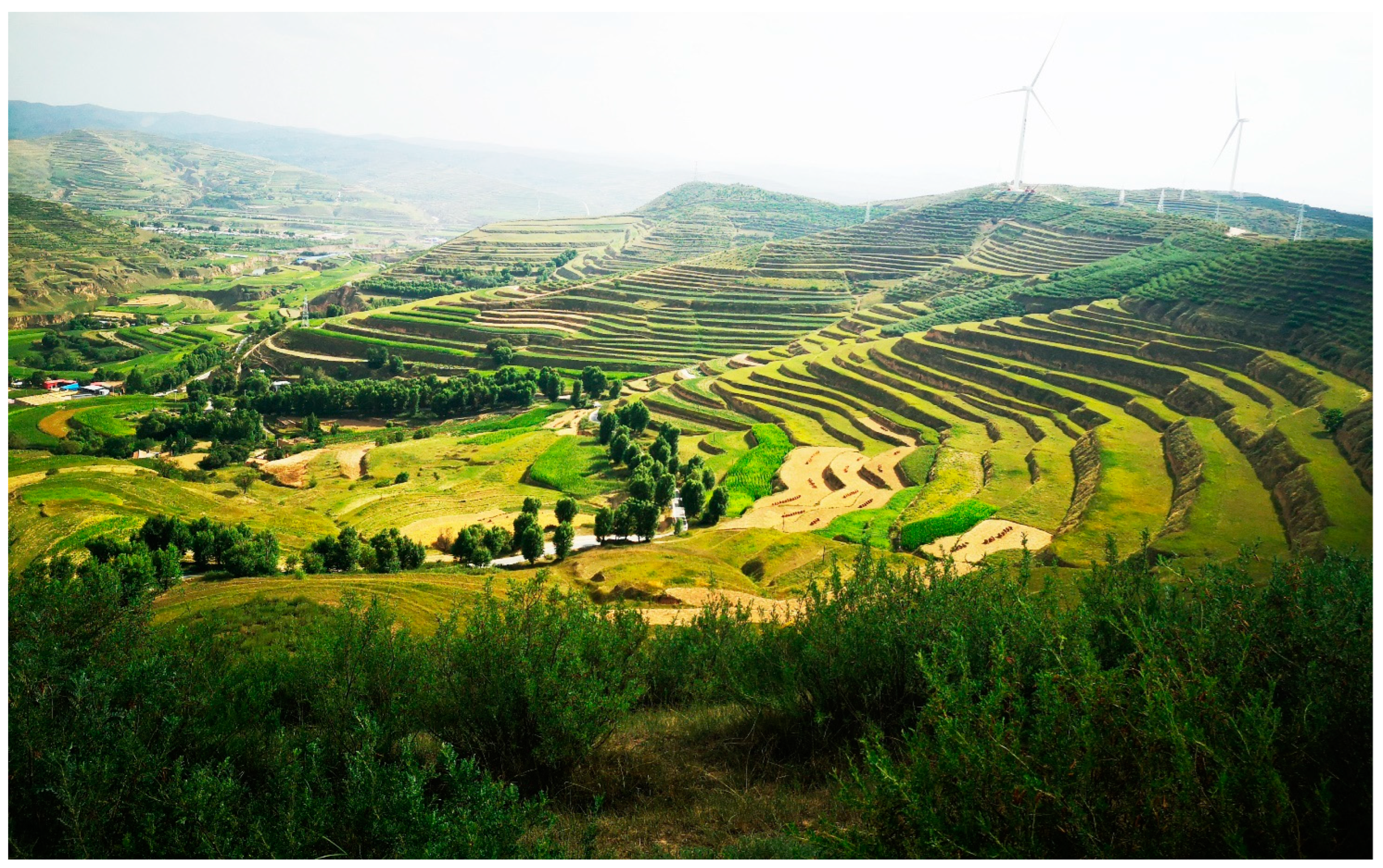
2.1. Site Description
2.2. Experiment Design
2.3. Sampling and Measurements
2.4. Data Analysis
3. Results
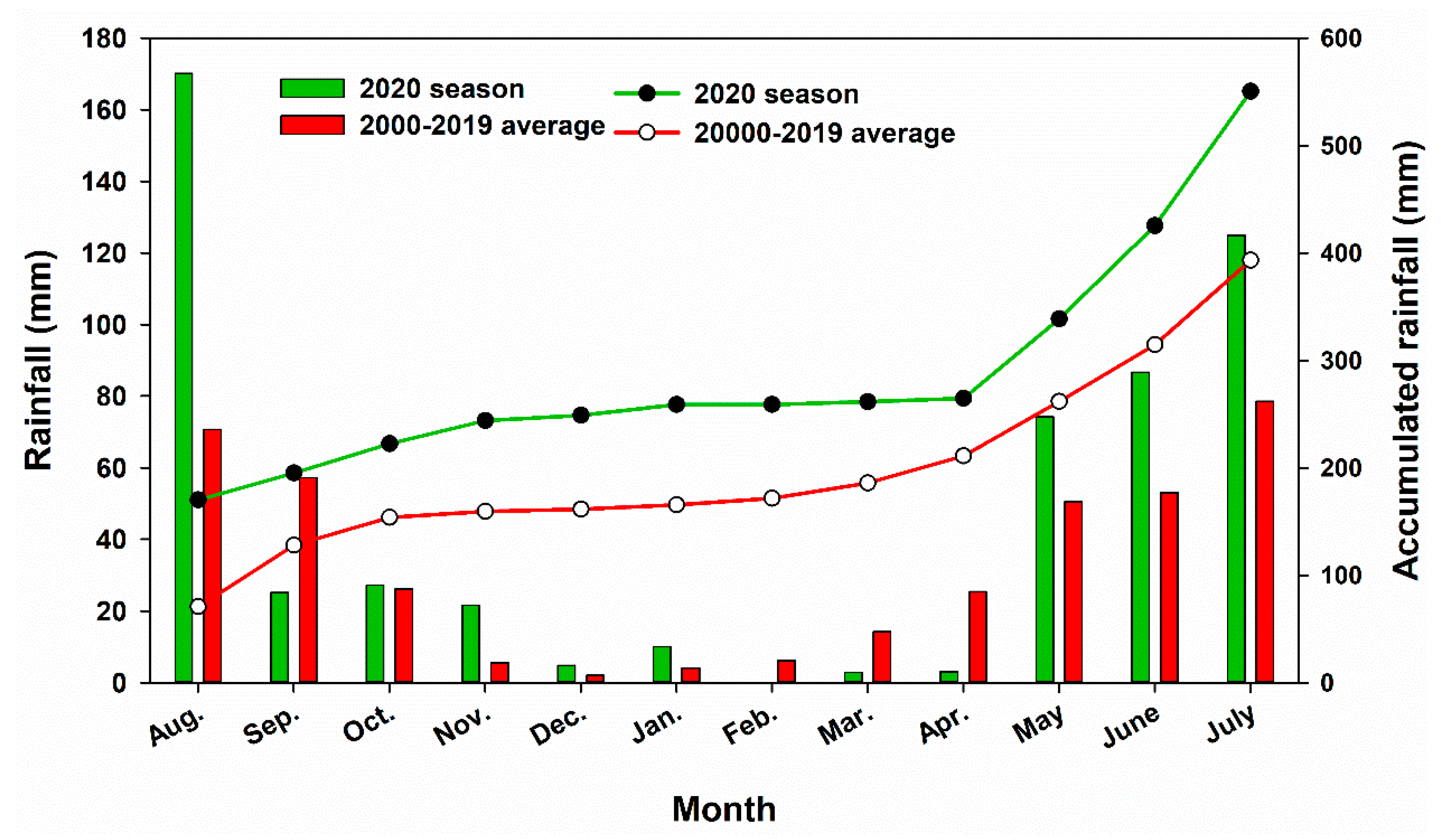
3.1. Precipitation
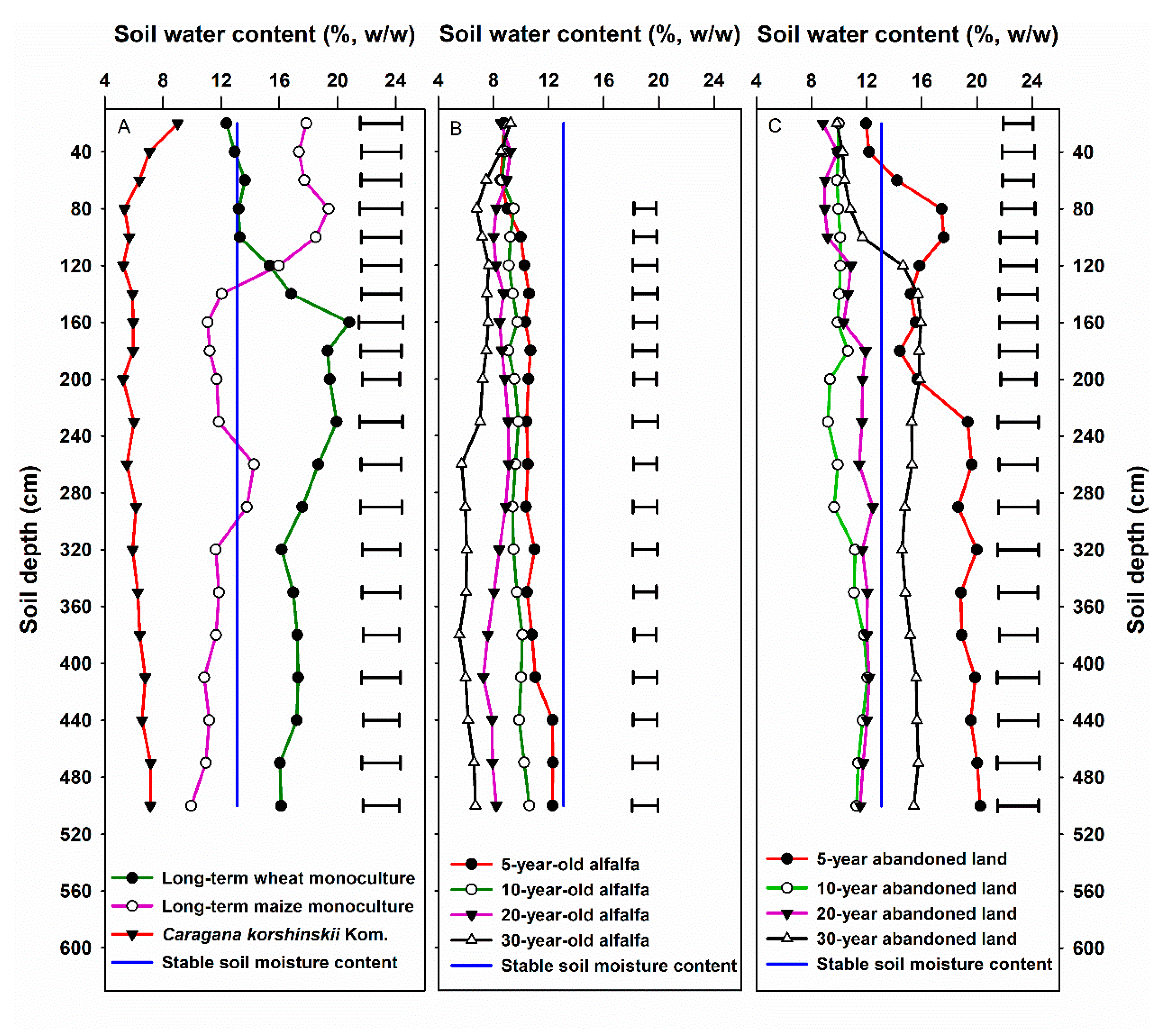
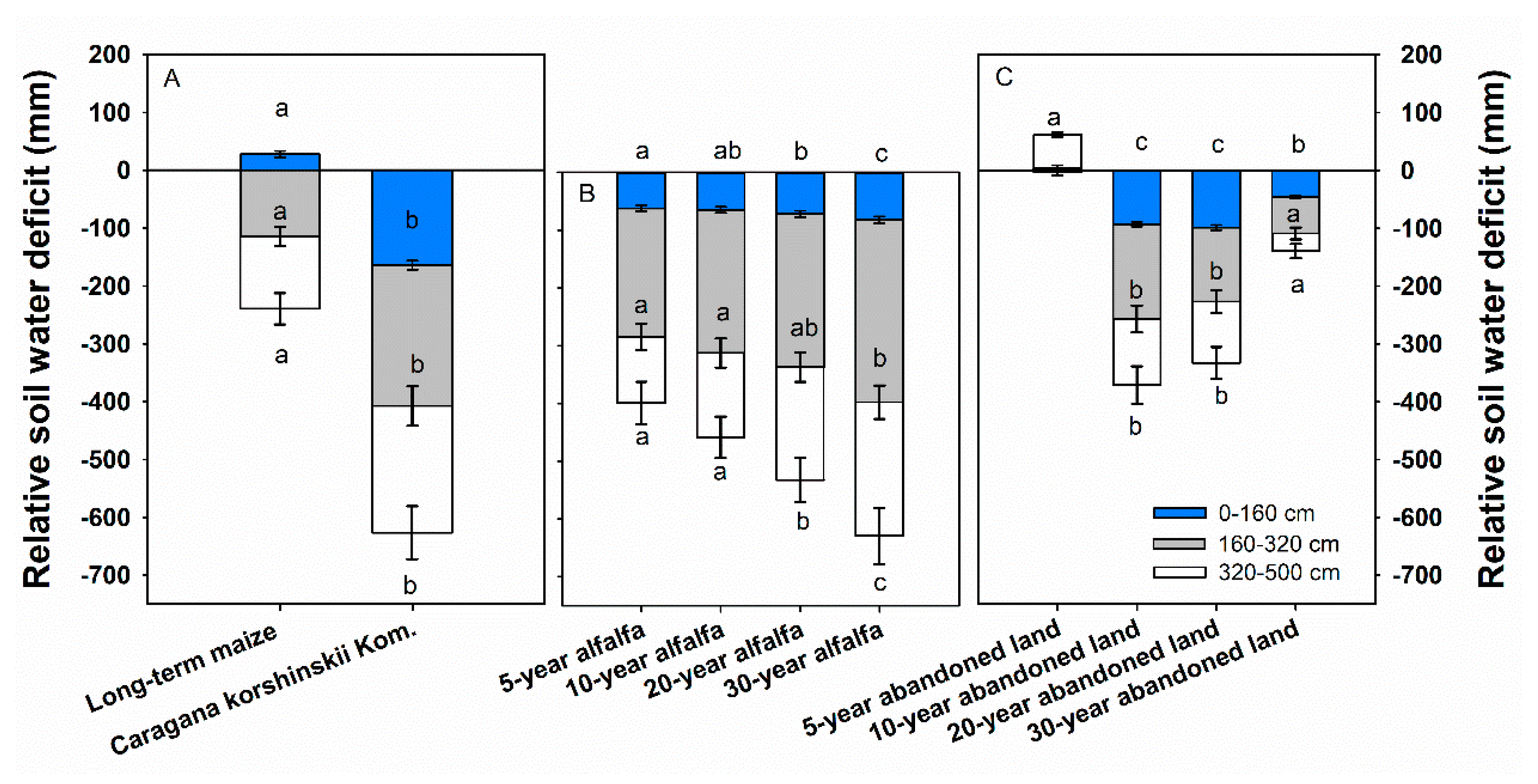
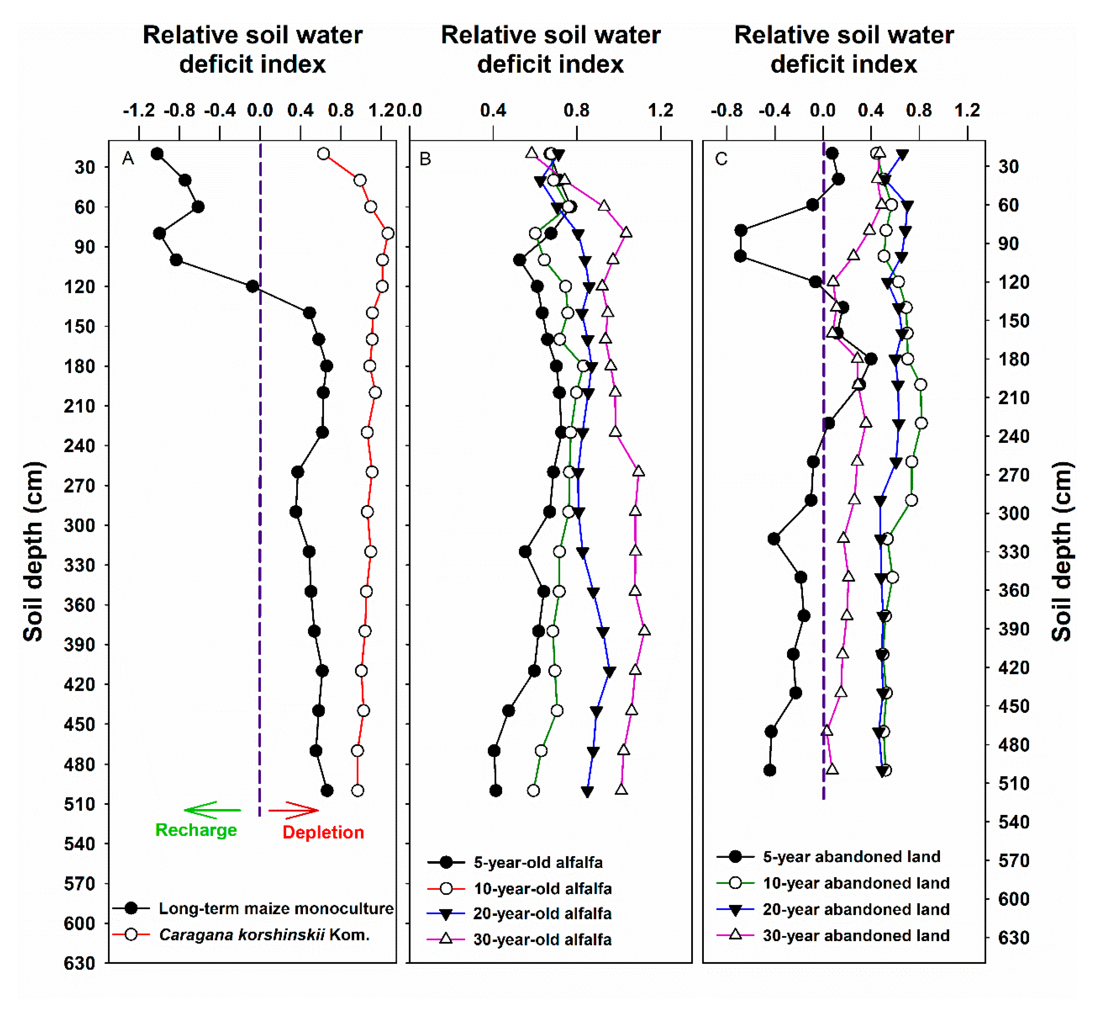
3.2. Soil Water Content and Water Deficit
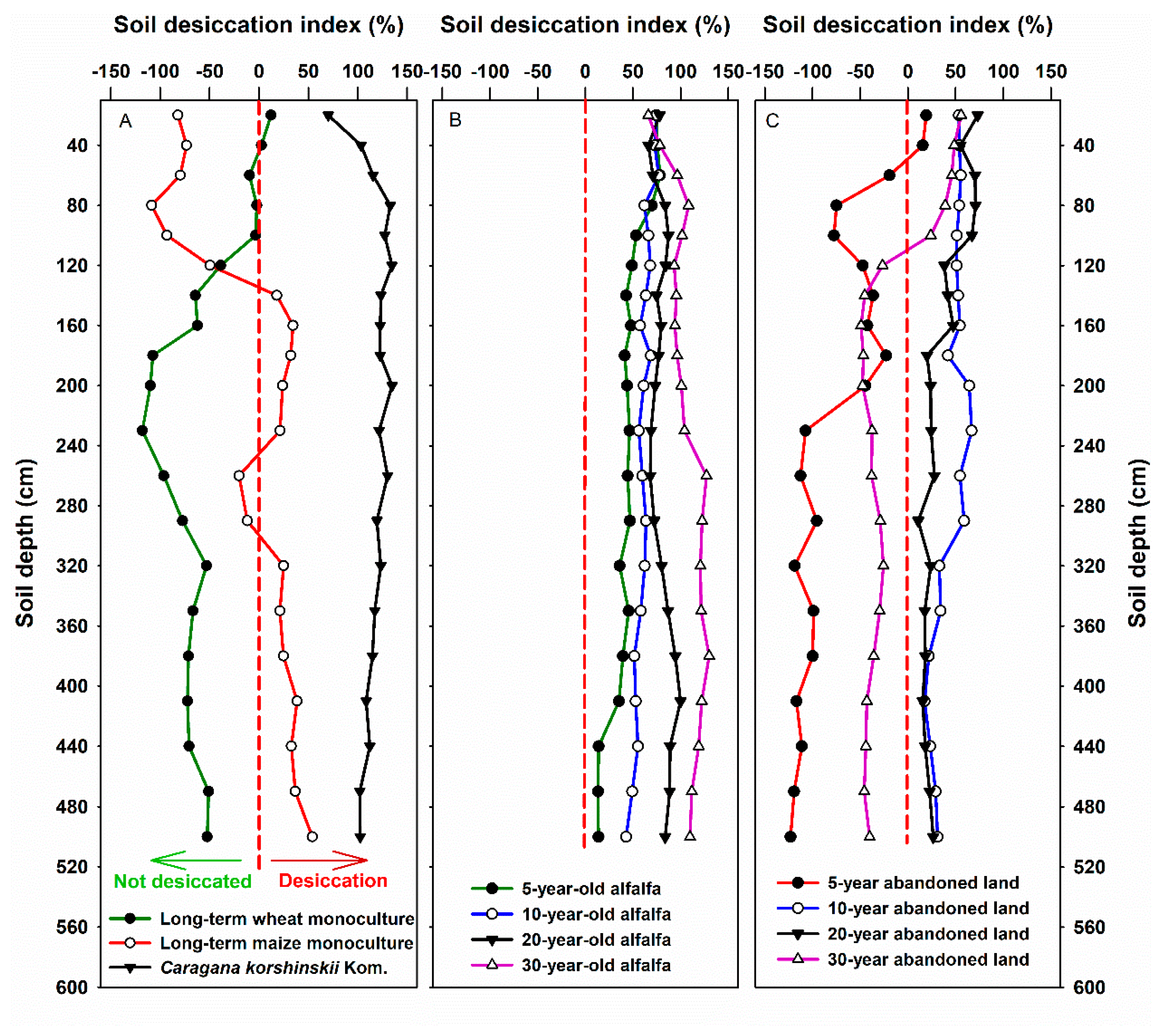
3.3. Soil Desiccation Indices
4. Discussion
5. Conclusions
Author Contributions
Funding
Institutional Review Board Statement
Informed Consent Statement
Data Availability Statement
Acknowledgments
Conflicts of Interest
References
- Chen, H.; Zhang, W.; Wang, K.; Fu, W. Soil moisture dynamics under different land uses on karst hillslope in northwest Guangxi, China. Environ. Earth Sci. 2010, 61, 1105–1111. [Google Scholar] [CrossRef]
- Wang, Y.; Sun, H.; Fu, Z.; Fan, J.; Hu, W.; Fang, L. Response of deep soil drought to precipitation, land use and topography across a semi-arid watershed. Agric. For. Meteorol. 2020, 282, 107866. [Google Scholar]
- Wang, Y.; Zhang, C.; Han, X.; Mao, T.; Jia, X. Choosing an optimal land-use pattern for restoring eco-environments in a semi-arid region of the Chinese Loess Plateau. Ecol. Eng. 2015, 74, 213–222. [Google Scholar] [CrossRef]
- Nosetto, M.; Jobbágy, E.G.; Toth, T.; Di Bella, C.M. The effects of tree establishment on water and salt dynamics in naturally salt-affected grasslands. Oecologia 2007, 152, 695–705. [Google Scholar] [CrossRef] [PubMed]
- Guillod, B.; Orlowsky, B.; Miralles, D.G.; Teuling, A.J.; Seneviratne, S.I. Reconciling spatial and temporal soil moisture effects on afternoon rainfall. Nat. Commun. 2015, 6, 6443. [Google Scholar] [CrossRef]
- Sun, G.; Zhou, G.; Zhang, Z.; Wei, X.; McNulty, S.G.; Vose, J.M. Potential water yield reduction due to forestation across China. J. Hydrol. 2006, 328, 548–558. [Google Scholar] [CrossRef]
- Wu, G.-L.; Yang, Z.; Cui, Z.; Liu, Y.; Fang, N.-F.; Shi, Z.-H. Mixed artificial grasslands with more roots improved mine soil infiltration capacity. J. Hydrol. 2016, 535, 54–60. [Google Scholar] [CrossRef]
- Ziadat, F.M.; Taimeh, A.Y. Effect of rainfall intensity, slope, land use and antecedent soil moisture on soil erosion in an arid environment. Land Degrad. Dev. 2013, 24, 582–590. [Google Scholar] [CrossRef]
- Duan, C.; Fang, L.; Yang, C.; Chen, W.; Cui, Y.; Li, S. Reveal the response of enzyme activities to heavy metals through in situ zymography. Ecotoxicol. Environ. Saf. 2018, 156, 106–115. [Google Scholar] [CrossRef]
- Chen, L.; Wang, J.; Wei, W.; Fu, B.; Wu, D. Effects of landscape restoration on soil water storage and water use in the Loess Plateau Region, China. For. Ecol. Manag. 2010, 259, 1291–1298. [Google Scholar] [CrossRef]
- Chen, Y.; Wang, K.; Lin, Y.; Shi, W.; Song, Y.; He, X. Balancing green and grain trade. Nat. Geosci. 2015, 8, 739–741. [Google Scholar] [CrossRef]
- Jun, F.; Mingan, S.; QuanJiu, W.; Jones, S.B.; Reichardt, K.; Xiangrong, C.; Xiaoli, F. Toward sustainable soil and water resources use in China’s highly erodible semi-arid loess plateau. Geoderma 2010, 155, 93–100. [Google Scholar] [CrossRef]
- Ge, J.; Fan, J.; Yuan, H.; Yang, X.; Jin, M.; Wang, S. Soil water depletion and restoration under inter-conversion of food crop and alfalfa with three consecutive wet years. J. Hydrol. 2020, 585, 124851. [Google Scholar] [CrossRef]
- Liu, Y.; Miao, H.-T.; Huang, Z.; Cui, Z.; He, H.; Zheng, J.; Han, F.; Chang, X.; Wu, G.-L. Soil water depletion patterns of artificial forest species and ages on the Loess Plateau (China). For. Ecol. Manag. 2018, 417, 137–143. [Google Scholar] [CrossRef]
- Wang, L.; Xie, J.; Luo, Z.; Niu, Y.; Coulter, J.A.; Zhang, R.; Lingling, L. Forage yield, water use efficiency, and soil fertility response to alfalfa growing age in the semiarid Loess Plateau of China. Agric. Water Manag. 2020, 243, 106415. [Google Scholar] [CrossRef]
- Li, Y. Productivity dynamic of alfalfa and its effects on water eco-environment. Acta Pedol. Sin. 2002, 39, 404–411, (In Chinese with English Abstract). [Google Scholar]
- Mu, X.; Xu, X.; Wang, W. Impact of artificial forest on soil moisture of the deep soil layer on Loess Plateau. Acta Pedol. Sin. 2003, 40, 217–222. [Google Scholar]
- Shao Ma Wang, Y.; Xia, Y.; Jia, X. Soil drought and water carrying capacity for vegetation in the critical zone of the Loess Plateau: A review. Vadose Zone J. 2018, 17, 1–8. [Google Scholar]
- Yang, G.; Rong, L. Effects of artificial vegetation types on soil moisture, carbon and nitrogen in the hill and gully area of the Loess Plateau. Bull. Soil Water Conserv. 2007, 27, 30–33, (In Chinese with English Abstract). [Google Scholar]
- Ning, T.; Guo, Z.; Guo, M.; Han, B. Soil water resources use limit in the loess plateau of China. Agric. Sci. 2013, 04, 100–105. [Google Scholar] [CrossRef] [Green Version]
- Wang, Y.; Shao, M.; Liu, Z.; Zhang, C. Characteristics of Dried Soil Layers Under Apple Orchards of Different Ages and Their Applications in Soil Water Managements on the Loess Plateau of China. Pedosphere 2015, 25, 546–554. [Google Scholar] [CrossRef]
- Zhang, X.; Zhao, W.; Liu, Y.; Fang, X.; Feng, Q.; Chen, Z. Spatial variations and impact factors of soil water content in typical natural and artificial grasslands: A case study in the Loess Plateau of China. J. Soils Sediments 2016, 17, 157–171. [Google Scholar] [CrossRef]
- Wang, Y.; Shao, M.; Shao, H. A preliminary investigation of the dynamic characteristics of dried soil layers on the Loess Plateau of China. J. Hydrol. 2010, 381, 9–17. [Google Scholar] [CrossRef]
- Fan, J.; Wang, Q.; Jones, S.B.; Shao, M. Soil water depletion and recharge under different land cover in China’s Loess Plateau. Ecohydrology 2016, 9, 396–406. [Google Scholar] [CrossRef]
- Lesschen, J.; Cammeraat, L.; Nieman, T. Erosion and terrace failure due to agricultural land abandonment in a semi-arid environment. Earth Surf. Processes Landf. J. Br. Geomorphol. Res. Group 2008, 33, 1574–1584. [Google Scholar] [CrossRef]
- Du, F.; Shao, H.-B.; Shan, L.; Liang, Z.-S.; Shao, M.-A. Secondary succession and its effects on soil moisture and nutrition in abandoned old-fields of hilly region of Loess Plateau, China. Colloids Surf. B Biointerfaces 2007, 58, 278–285. [Google Scholar] [CrossRef]
- Jiang, H. Dynamics of Soil Organic Carbon, Fertilit and Water in Different Land Uses from the Semi-Arid Loess Plateau, China; Lanzhou University: Lanzhou, China, 2006. [Google Scholar]
- An, W.; Liang, H.; Wang, C.; Wang, S.; Li, Z.; Fu, B. Dynamic characteristic of soil water with an increase in restoration years on the shady and sunny slope aspects of the Loess Plateau. Acta Ecol. Sin. 2017, 37, 4023–4026. [Google Scholar]
- Wang, Y.; Ma, P.; Xu, H.; Wan, H.; Dong, L.; Cai, J. Soil hydro physical characteristics of abandoned terraced fields with dif-ferent years in loess region of South Ningxia. J. Jiangsu Agric. Sci. 2019, 21, 293–297. [Google Scholar]
- Liu, X. Dynamics of Soil Organic Carbon, Nutrients and Water in Different Vegetation Restoration and Land Use Types in the Semi-arid Loess Plateau of China; Lanzhou University: Lanzhou, China, 2009. [Google Scholar]
- Gong, Z. Chinese Soil Taxonomy; Science Press: Beijing, China, 2001. [Google Scholar]
- FAO; ISSS; ISRIC. World Reference Base for Soils Resources; World Soil Resource Report No. 103; FAO: Rome, Italy, 2006. [Google Scholar]
- Peng, Z.; Wang, L.; Xie, J.; Li, L.; Coulter, J.A.; Zhang, R.; Luo, Z.; Cai, L.; Carberry, P.; Whitbread, A. Conservation tillage increases yield and precipitation use effi-ciency of wheat on the semi-arid Loess Plateau of China. Agric. Water Manag. 2020, 231, 106024. [Google Scholar] [CrossRef]
- Xie, J.; Wang, L.; Li, L.; Coulter, J.A.; Chai, Q.; Zhang, R.; Luo, Z.; Carberry, P.; Rao, K.P.C. Subsoiling increases grain yield, water use efficiency, and eco-nomic return of maize under a fully mulched ridge-furrow system in a semi-arid environment in China. Soil Tillage Res. 2020, 199, 104584. [Google Scholar] [CrossRef]
- Wang, L.; Palta, J.; Chen, W.; Chen, Y.; Deng, X. Nitrogen fertilization improved water-use efficiency of winter wheat through increasing water use during vegetative rather than grain filling. Agric. Water Manag. 2018, 197, 41–53. [Google Scholar] [CrossRef]
- Bian, Y.; Song, N.; Wang, X. Soil water deficit under different land-use type in desert steppe. J. Soil Water Conserv. 2015, 29, 201–206. [Google Scholar]
- Zhang, C.; Wang, Y.; Jia, X.; An, Z. Variations in capacity and storage of plant-available water in deep profiles along a re-vegetation and precipitation gradient. J. Hydrol. 2020, 581, 124401. [Google Scholar] [CrossRef]
- Zhang, J.; Wang, L. The impact of land use on water loss and soil desiccation in the soil profile. Appl. Hydrogeol. 2017, 26, 185–196. [Google Scholar] [CrossRef]
- Zhu, Y.; Jia, X.; Shao, M. Loess Thickness Variations Across the Loess Plateau of China. Surv. Geophys. 2018, 39, 715–727. [Google Scholar] [CrossRef]
- Canadell, J.; Jackson, R.B.; Ehleringer, J.B.; Mooney, H.A.; Sala, O.; Schulze, E.-D. Maximum rooting depth of vegetation types at the global scale. Oecologia 1996, 108, 583–595. [Google Scholar] [CrossRef]
- Lucas-Borja, M.E.; Zema, D.A.; Plaza-Álvarez, P.A.; Zupanc, V.; Baartman, J.; Sagra, J.; González-Romero, J.; Moya, D.; de las Heras, J. Effects of Different Land Uses (Abandoned Farmland, Intensive Agriculture and Forest) on Soil Hydrological Properties in Southern Spain. Water 2019, 11, 503. [Google Scholar] [CrossRef] [Green Version]
- Li, F.M.; Li, X.G.; Javaid, M.M.; Ashraf, M.; Zhang, F. Ridge-furrow plastic film mulching farming for sustainable dryland agri-culture on the Chinese loess plateau. Agron. J. 2020, 112, 3284–3294. [Google Scholar] [CrossRef]
- Ren, A.-T.; Zhou, R.; Mo, F.; Liu, S.-T.; Li, J.-Y.; Chen, Y.; Zhao, L.; Xiong, Y.-C. Soil water balance dynamics under plastic mulching in dryland rainfed agroecosystem across the Loess Plateau. Agric. Ecosyst. Environ. 2021, 312, 107354. [Google Scholar] [CrossRef]
- Zhang, X.; Wang, H.; Hou, H.; Yu, X.; Ma, Y.; Fang, Y.; Kangning, L. Did plastic mulching constantly increase crop yield but decrease soil water in a semi-arid rain-fed area? Agric. Water Manag. 2020, 241, 106380. [Google Scholar] [CrossRef]
- Shangguan, Z.; Zhang, H. Suggestions on Strengthening Cultivated Land Conservation in Northwest China. China Science Daily. 2016. Available online: http://newssciencenetcn/htmlnews/2016/2/338321shtm?id=338321/ (accessed on 17 February 2016).
- Ren, J.; Li, J.; Wang, X.; Fang, X. Soil water and nutrient characteristics of alfalfa grasslands at semi-arid and semi-arid prone to drought areas in southern Ningxia. Acta Ecol. Sin. 2011, 31, 3638–3649. [Google Scholar]
- Li, Y. The properties of water cycle in soil and their effect on water cycle for land in the Loess Plateau. Acta Ecol. Sin. 1983, 3, 91–101. [Google Scholar]
- Wang, Y.; Shao, M.; Liu, Z. Large-scale spatial variability of dried soil layers and related factors across the entire Loess Plateau of China. Geoderma 2010, 159, 99–108. [Google Scholar] [CrossRef]
- Ali, G.; Wang, Z.; Li, X.; Jin, N.; Chu, H.; Jing, L. Deep soil water deficit and recovery in alfalfa fields of the Loess Plateau of China. Field Crop. Res. 2020, 260, 107990. [Google Scholar] [CrossRef]
- Ghaiumi, M.A.M.; Ghorbani, D.S.; Raiesi, F.; Tahmasbi, P. Effect of land abandonment on variation of soil water infiltra-tion parameters. Joural Water Soil Resour. Conserv. 2013, 2, 41–51. [Google Scholar]
- Li, J.; Li, Z.; Guo, M.; Li, P.; Cheng, S.; Yuan, B. Effects of vegetation restoration on soil physical properties of abandoned farm-land on the Loess Plateau, China. Environ. Earth Sci. 2018, 77, 1–9. [Google Scholar] [CrossRef]
- Liu, Y.; Cui, Z.; Huang, Z.; López-Vicente, M.; Wu, G. Influence of soil moisture and plant roots on the soil infiltration capaci-ty at different stages in arid grasslands of China. Catena 2019, 182, 104147. [Google Scholar] [CrossRef]


| Land uses | Aspect | Ground Coverage (%) | Vegetation Types | Dominant Species |
|---|---|---|---|---|
| Farmland 1 | south | – | 12-year wheat monoculture | Triticum aestivum L. |
| Farmland 2 | south | – | 12-year maize monoculture | Zea mays L. |
| Artificial forestland | south | 50 | 25-year-old shrub | Caragana korshinskii Kom. |
| Artificial grassland | south | 90 | 5-year-old alfalfa | Medicago sativa L. |
| south | 90 | 10-year-old alfalfa | Medicago sativa L. | |
| south | 90 | 20-year-old alfalfa | Medicago sativa L. | |
| south | 90 | 30-year-old alfalfa | Medicago sativa L. | |
| Abandoned land (Natural re-vegetation) | south | 75 | 5-year-old abandoned land | Agropyron cristatum (L.) Gaertn. |
| south | 85 | 10-year-old abandoned farmland | Agropyron cristatum (L.) Gaertn. | |
| south | 80 | 20-year-old abandoned farmland | Agropyron cristatum (L.) Gaertn. | |
| south | 75 | 30-year-old abandoned farmland | Agropyron cristatum (L.) Gaertn. |
| Vegetation Type | Plant-Available Water Storage (mm) | ||||
|---|---|---|---|---|---|
| 0–100 cm | 101–200 cm | 201–350 cm | 351–500 cm | Sum (0–500 cm) | |
| Long-term wheat | 71.0 c a | 135.3 a | 194.2 b | 174.6 b | 575.1 a |
| Long-term maize | 130.9 a | 63.8 d | 100.6 d | 68.9 e | 364.2 b |
| Caragana korshinskii Kom. | −4.5 h | −17.0 g | −20.0 i | −5.0 g | −46.5 f |
| 5-year alfalfa | 23.5 f | 40.7 e | 62.2 f | 83.8 d | 210.2 c |
| 10-year alfalfa | 23.7 f | 27.5 fg | 45.1 gh | 55.3 e | 151.6 d |
| 20-year alfalfa | 18.9 f | 17.7 g | 29.3 h | 12.6 f | 78.5 e |
| 30-year alfalfa | 9.5 g | 5.0 h | −16.8 i | −16.0 g | −18.3 g |
| 5-year abandoned land | 90.7 b | 99.1 c | 219.7 a | 227.4 a | 636.9 a |
| 10-year abandoned land | 34.6 de | 35.1 ef | 56.1 g | 82.3 d | 208.1 c |
| 20-year abandoned land | 25.3 ef | 48.1 e | 86.2 e | 86.8 d | 246.4 c |
| 30-year abandoned land | 42.8 d | 102.1 b | 141.5 c | 151.8 c | 438.2 b |
| Vegetation Type | Soil Water Storage Deficit Degree (%) | ||||
|---|---|---|---|---|---|
| 0–100 cm | 101–200 cm | 201–350 cm | 351–500 cm | 0–500 cm | |
| Long-term wheat | 38.6 d a | 13.8 e | 16.1 e | 21.2 d | 22.4 f |
| Long-term maize | 14.7 e | 41.8 c | 40.5 c | 48.8 c | 36.5 c |
| Caragana korshinskii Kom. | 68.6 a | 73.4 a | 72.0 a | 68.1 a | 70.5 a |
| 5-year alfalfa | 57.8 bc | 50.8 b | 50.5 bc | 44.9 c | 51.0 bc |
| 10-year alfalfa | 57.9 bc | 56.0 b | 55.0 b | 52.3 bc | 55.3 bc |
| 20-year alfalfa | 59.7 bc | 59.8 b | 59.1 b | 63.5 ab | 60.5 ab |
| 30-year alfalfa | 63.2 ab | 64.8 ab | 71.1 a | 70.9 a | 67.5 a |
| 5-year abandoned land | 31.1 d | 28.0 d | 9.5 f | 7.4 e | 19.0 f |
| 10-year abandoned land | 53.2 c | 53.0 b | 52.1 b | 45.3 c | 50.9 bc |
| 20-year abandoned land | 57.0 bc | 47.9 bc | 44.3 c | 44.1 c | 48.3 c |
| 30-year abandoned land | 50.2 c | 26.8 d | 29.8 d | 27.2 d | 33.5 d |
| Vegetation Type | DSLFD a | Thickness of the DSL | Soil Water Deficit in the DSL | Mean SW in the DSL |
|---|---|---|---|---|
| cm | cm | mm | g kg−1 | |
| Long-term wheat | − | 0 c | − | − |
| Long-term maize | 160 a b | 240 b c | 68.1 c | 112.7 a |
| Caragana korshinskii Kom. | 160 a | 340 a | 263.4 a | 62.5 d |
| 5-year alfalfa | 160 a | 340 a | 66.7 c | 110.5 a |
| 10-year alfalfa | 160 a | 340 a | 119.1 b | 97.7 b |
| 20-year alfalfa | 160 a | 340 a | 180.9 b | 83.2 c |
| 30-year alfalfa | 160 a | 340 a | 262.8 a | 63.6 d |
| 5-year abandoned land | − | 0 c | − | − |
| 10-year abandoned land | 160 a | 340 a | 77.4 c | 107.7 ab |
| 20-year abandoned land | 160 a | 340 a | 33.7 d | 118.7 a |
| 30-year abandoned land | − | 0 c | − | − |
Publisher’s Note: MDPI stays neutral with regard to jurisdictional claims in published maps and institutional affiliations. |
© 2022 by the authors. Licensee MDPI, Basel, Switzerland. This article is an open access article distributed under the terms and conditions of the Creative Commons Attribution (CC BY) license (https://creativecommons.org/licenses/by/4.0/).
Share and Cite
Wang, L.; Luo, Z.; Li, L.; Xie, J.; Fudjoe, S.K.; Zechariah, E. Land Use Affects Soil Water Balance and Soil Desiccation within the Soil Profile: Evidence from the Western Loess Plateau Case. Land 2022, 11, 1136. https://doi.org/10.3390/land11081136
Wang L, Luo Z, Li L, Xie J, Fudjoe SK, Zechariah E. Land Use Affects Soil Water Balance and Soil Desiccation within the Soil Profile: Evidence from the Western Loess Plateau Case. Land. 2022; 11(8):1136. https://doi.org/10.3390/land11081136
Chicago/Turabian StyleWang, Linlin, Zhuzhu Luo, Lingling Li, Junhong Xie, Setor Kwami Fudjoe, and Effah Zechariah. 2022. "Land Use Affects Soil Water Balance and Soil Desiccation within the Soil Profile: Evidence from the Western Loess Plateau Case" Land 11, no. 8: 1136. https://doi.org/10.3390/land11081136
APA StyleWang, L., Luo, Z., Li, L., Xie, J., Fudjoe, S. K., & Zechariah, E. (2022). Land Use Affects Soil Water Balance and Soil Desiccation within the Soil Profile: Evidence from the Western Loess Plateau Case. Land, 11(8), 1136. https://doi.org/10.3390/land11081136