An Integrated Approach for Assessing Aquatic Ecological Carrying Capacity: A Case Study of Wujin District in the Tai Lake Basin, China


Abstract
:1. Introduction
2. Materials and Methods
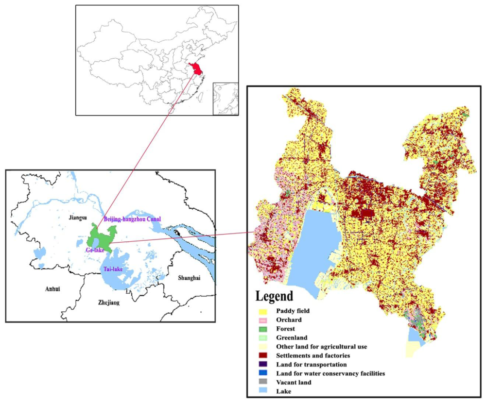
2.1. Study Area
2.2. Data Description
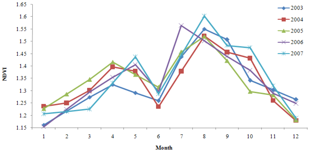
- MODIS NDVI time-series products: the monthly composite MODIS 250 m normalized difference vegetation index (NDVI) dataset spanning five growing seasons (January 2003 to December 2007) were created for the research area.
- Field monitoring data: field data were obtained from Changzhou Conservancy Bureau, listing parameters describing monthly water conditions such as total phosphorous (TP), total nitrogen (TN) and chemical oxygen demand (COD) concentrations (January, 2007 to August, 2009).
- Land use map: land use data for 2005 were obtained from the land use survey database, at the scale of 1:10000.
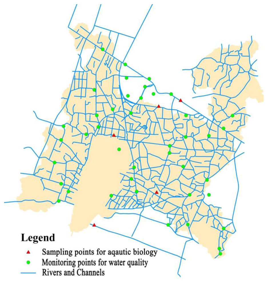
- Hydrological network map: the distribution map of primary and secondary river channels was obtained from the hydrological network map of the whole of Changzhou city.
- DEM data: elevation data and slope data were provided by ISDSP (International Scientific Data Service Platform) with the spatial resolution of 30 m (2009).
- Statistical data: Statistical Yearbooks of Wujin District from 2000 to 2008 were obtained in which population and economic data were included.
- Auxiliary data: other data collected included the local Water Conservancy Construction Report in the National Eleventh Five-Year Plan (2005 to 2020), the local Social and Development Planning Report (2005–2020), agricultural and aquatic development planning reports and so on.
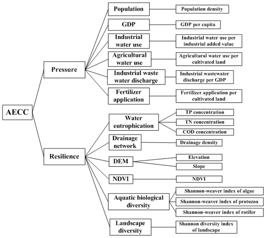
2.3. Selection of Indicators
2.4. Normalized Difference Vegetation Index Extraction
2.5. Integrated Assessment
3. Results and Discussions
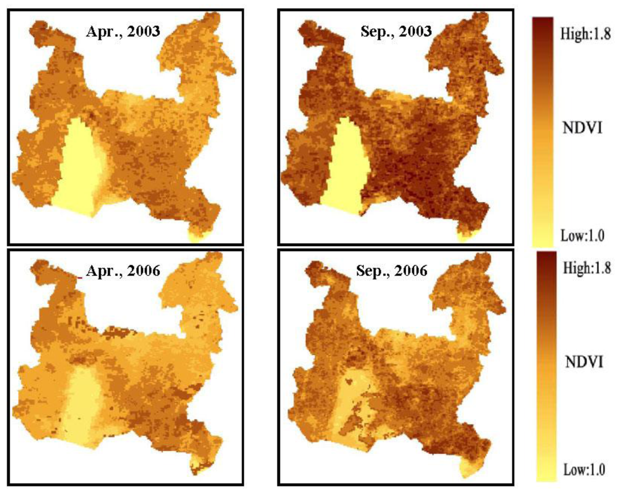
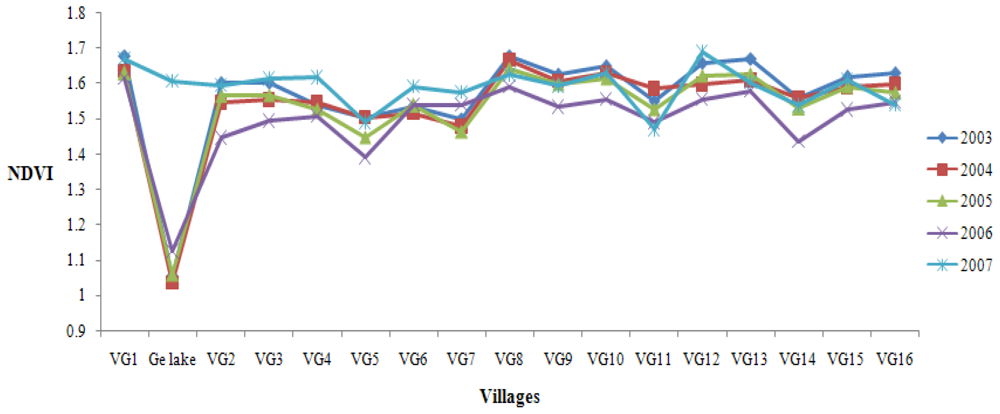
3.1. NDVI Extraction and Analysis
3.2. Integrated Assessment of Aquatic Ecological Carrying Capacity
3.3. Discussion
4. Conclusions
- Social, economic and ecological context was explicitly investigated in our case, formulating the background for the identification of indicators and the establishment of indicator hierarchy.
- The spatial and temporal variation of NDVI was carried out and the extension of vegetation cover into Ge Lake was observed, which should be paid more attention by local authorities.
- Ecological resilience assessment was made with the integrated consideration of aquatic and terrestrial ecosystems, in which RS and GIS technologies were of great assistance in obtaining the final result.
- Vegetation cover has increased in central and eastern parts of Wujin District in the past few years, which could be observed in NDVI products. However, the phenomena of cyanobacteria bloom and the decreasing of water area make it imperative to reduce agricultural activities around Ge Lake, since it will impair the aquatic ecological balance and aggravate water eutrophication.
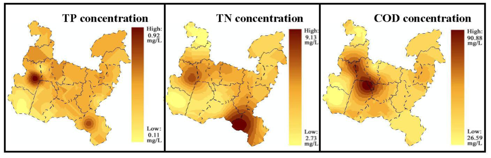
- Concentrations of COD, TN and TP were considerably higher than the national standards for pollutant emission; thus water eutrophication was still diagnosed as the main problem in Wujin District. As a result, it is suggested that pollutant emission reduction should be strengthened, especially for industrial waste water discharge and agricultural activities.
- In the long run, aquatic ecological carrying capacity has increased slightly, which reveals that government planning on land use, economic growth, population growth and technological levels was able to improve water management and could be reasonably conducted.
Acknowledgements
References
- Seidl, I; Tisdell, CA. Carrying capacity reconsidered: From Malthus’ theory to cultural carrying capacity. Ecol. Econ 1999, 31, 395–408. [Google Scholar]
- Zuo, QT; Ma, JX; Wu, ZN. Concepts and models of supporting capacity of water resources in urban areas. In Proceedings of Sustainable Water Management for Large Cities; IAHS, Foz do Iguaco: Brazil, April, 2005; p. 293. [Google Scholar]
- Feng, LH; Zhang, XC; Luo, GY. Application of system dynamics in analyzing the carrying capacity of water resources Yiwu City, China. Math. Comput. Simulat 2008, 7, 269–278. [Google Scholar]
- Daly, HE; Cobb, JB. For the Common Good: Redirecting the Economy toward Community, the Environment, and a Sustainable Future; Beacon Press: Boston, MA, USA, 1989. [Google Scholar]
- Wang, SC. Analysis and regulation on water environmental carrying capacity. China Water Resour 2001, 11, 9–12. [Google Scholar]
- Li, QL; Wang, LG; Zhang, HZ; Yan, XX. Research and prospect on theoretical framework of water environmental bearing capacity. Geogr. Geo-Infor. Sci 2004, 2, 87–89. [Google Scholar]
- Pettorelli, N; Vik, JO; Mysterud, A; Gaillard, JM; Tucker, CJ; Stenseth, C. Using the satellite-derived NDVI to assess ecological responses to environmental changes. Trends Ecol. Evol 2005, 20, 503–510. [Google Scholar]
- Zhu, YH; Drake, S; Lu, HS; Xia, J. Analysis of temporal and spatial differences in eco-environmental carrying capacity related to water in the Haihe River Basin. Water Resour. Manag 2010, 24, 1089–1105. [Google Scholar]
- Gao, JX. Exploration of Sustainable Development-Theory. In Methods and Application of Ecological Carrying Capacity; Environment and Science Press: Beijing, China, 2001. [Google Scholar]
- Wang, QG; Gu, G; Higano, Y. Towards integrated environmental management for challenges in Water Environmental Protection of Lake Taihu Basin in China. Environ. Manage 2006, 37, 579–588. [Google Scholar]
- Ma, RH; Duan, HT; Gu, XH; Zhang, SX. Detecting aquatic vegetation changes in Taihu Lake, China Using Multi-temporal satellite imagery. Sensors 2008, 8, 3988–4005. [Google Scholar]
- Vemeer, EB. Industrial pollution in China and remedial polices. The China Quarterly 1998, 56, 952–985. [Google Scholar]
- Wang, M; Webber, M; Finlayson, B; Barnett, J. Rural industries and water pollution in China. J. Environ. Manage 2008, 86, 648–659. [Google Scholar]
- Ellis, EC; Wang, SM. Sustainable traditional agricultural in the Tai Lake region of China. Agr. Ecosyst. Environ 1997, 61, 177–193. [Google Scholar]
- Cao, ZH; Zhang, HC. Phosphorus losses to water from lowland rice fields under rice-wheat double cropping system in the Tai Lake region. Environ. Geochem. Health 2004, 26, 229–236. [Google Scholar]
- Zhu, ZL; Chen, DL. Nitrogen fertilizer use in China-contributions to food production, impacts on the environment and best management strategies. Nutr. Cycl. Agroecosys 2002, 63, 117–127. [Google Scholar]
- Giupponi, C; Mysiak, J; Fassio, A; Cogan, V. MULINO-DSS: A computer tool for sustainable use of water resources at the catchment scale. Math. Comput. Simul 2004, 64, 13–24. [Google Scholar]
- He, GZ; Long, LY; Ma, H; Wang, XL. Multi-indicator assessment of water environment in government environmental auditing. J. Environ. Sci 2007, 19, 494–501. [Google Scholar]
- Gong, L; Jin, CL. Fuzzy Comprehensive evaluation for carrying capacity of regional water resources. Water Resour. Manag 2009, 23, 2505–2513. [Google Scholar]
- Guo, HC; Liu, L; Huang, GH; Fuller, GA; Zou, R; Yin, YY. A system dynamics approach for watershed environmental management planning. J. Environ. Manage 2001, 61, 93–111. [Google Scholar]
- Leuven, R; Poudevigne, I. Riverine landscape dynamics and ecological risk assessment. Freshwater Biol 2002, 47, 845–865. [Google Scholar]
- Wickham, JD; Wade, TG. Watershed level risk assessment of nitrogen and phosphorus export. Comput. Electron. Agr 2002, 37, 15–24. [Google Scholar]
- Snepvangers, J; Heuvelink, GBM; Huisman, JA. Soil water content interpolation using spatio-temporal Kriging with external drift. Geodema 2003, 112, 253–271. [Google Scholar]
- Zhang, YC; Lin, S; Liu, JP; Qian, X; Ge, Y. Time-series MODIS image-based retrieval and distribution analysis of total suspended matter concentrations in Lake Taihu (China). Int. J. Environ. Res. Public Health 2010, 7, 3545–3560. [Google Scholar]
- Ellis, EC; Li, RG; Yang, LZ; Cheng, X. Changes in village-scale nitrogen storage in China’s Tai Lake region. Ecol. Appl 2000, 10, 1074–1089. [Google Scholar]
- Di, QB; Han, ZL; Liu, GC; Chang, HW. Carrying capacity of marine region in Liaoning Province. Chin. Geogr. Sci 2007, 17, 229–235. [Google Scholar]
- Yu, DL; Mao, HY. Regional carrying capacity-case studies of Bohai Rim area. J. Geogr. Sci 2002, 12, 177–185. [Google Scholar]
- Feng, Q; Endo, KN; Cheng, GD. Towards sustainable development of the environmentally degraded arid rivers of China-a case study from Tarim River. Environ. Geol 2001, 41, 229–238. [Google Scholar]
- Oh, K; Jeong, Y; Lee, D; Lee, W; Choi, J. Determining development density using the Urban Carrying Capacity Assessment System. Landscape Urban Plan 2005, 73, 1–15. [Google Scholar]
- Goodland, R; Daly, HE; Kellenberg, J. Burden sharing in the transition to environmental sustainability. Future 1994, 26, 146–155. [Google Scholar]
- Graham, RL; Hunsaker, CT; O’Neill, RV; Jackson, BL. Ecological risk assessment at the regional scale. Ecol. Appl 1991, 1, 196–206. [Google Scholar]
- Stirling, G; Wiley, B. Empirical relationships between species richness, evenness, and proportional diversity. Am. Nat 2001, 158, 286–299. [Google Scholar]
- Lloyd, D. A phenological classification of terrestrial vegetation cover using shortwave vegetation index imagery. Int. J. Remote Sens 1990, 11, 2269–2279. [Google Scholar]
- Soriano, A; Paruelo, JM. Biozones: vegetation units defined by functional characters identifiable with the aid of satellites sensor images. Global Ecol. Biogeogr 1992, 2, 82–89. [Google Scholar]
- Paruelo, JM; Tomasel, F. Prediction of functional characteristics of ecosystems: a comparison of artificial neural networks and regression models. Ecol. Model 1997, 98, 173–186. [Google Scholar]
- Gamon, JA; Field, CB; Goulden, ML; Hartley, AE; Joel, G; Penuelas, J; Valentini, R. Relationships between NDVI, canopy structure and photosynthesis in three Californian vegetation types. Ecol. Appl 1995, 5, 28–41. [Google Scholar]
- Rundquist, BC. The influence of canopy green vegetation fraction on spectral measurements over native tallgrass prairie. Remote Sens. Environ 2002, 81, 129–135. [Google Scholar]
- Griffith, JA. Geographical techniques and recent applications of remote sensing to landscape-water quality studies. Water Air Soil Poll 2002, 138, 181–197. [Google Scholar]
- Dong, J; Zhuang, DF; Xu, XL; Ying, L. Integrated evaluation of urban development suitability based on remote sensing and GIS techniques—A case study in Jingjinji Area, China. Sensor 2008, 8, 5975–5986. [Google Scholar]
- Walker, BH; Holling, CS; Carpenter, SR; Kinzig, AP. Resilience, adaptability and transformability in social-ecological systems. Ecol. Soc 2004, 9, 5:1–5:9. [Google Scholar]
- Folke, C. Resilience: The emergence of a perspective for social-ecological analyses. Global Environ. Chang 2006, 16, 253–267. [Google Scholar]
- Merem, E; Robinson, B; Wesley, JM; Yerramilli, S; Twumasi, YA. Using GIS in ecological management: green assessment of the impacts of petroleum activities in the State of Texas. Int. J. Environ. Res. Public Health 2010, 7, 2101–2130. [Google Scholar]


| Level | V | IV | III | II | I | |
|---|---|---|---|---|---|---|
| Score | 0–0.2 | 0.2–0.4 | 0.4–0.6 | 0.6–0.8 | 0.8–1 | |
| Indicator | Unit | Criteria | ||||
| Population density | /km2 | >1000 | 500–1000 | 400–500 | 200–400 | <200 |
| GDP per capita | 104 yuan per capita | <2 | 2–2.5 | 2.5–3.75 | 3.75–5 | >5 |
| Agricultural water use per cultivated land | 106 m3/ha | <30 or >142 | 30–60 or 112–142 | 60–69 or 103–112 | 69–73 or 99–103 | 73–99 |
| Industrial water use per industrial added value | m3/104 yuan | >100 | 56–100 | 45–56 | 31–45 | <31 |
| Fertilizer application per cultivated land | kg/ha | >1200 | 600–1200 | 525–600 | 300–525 | <300 |
| Industrial waste water per GDP | m3/104 yuan | >25 | 13–25 | 10–13 | 7–10 | <7 |
| Concentration of TP | mg/L | 0.9–1.3 | 0.2–0.9 | 0.05–0.2 | 0.01–0.05 | 0.001–0.01 |
| Concentration of TN | mg/L | 9–16 | 2–9 | 0.5–2 | 0.1–0.5 | 0.02–0.1 |
| Concentration of COD | mg/L | 40–60 | 10–40 | 4–10 | 1–4 | 0.15–1 |
| Drainage density | km/km2 | <0.5 | 0.5–2 | 2–4 | 4–6 | >6 |
| NDVI | / | <0.5 | 0.5–1.5 | 1.5–3 | 3–4.5 | >4.5 |
| Elevation | meter | >1000 | 500–1000 | 50–500 | 5–50 | <5 |
| Slope | degree | >25 | 10–25 | 5–10 | 1–5 | <1 |
| Aquatic biological Shannon diversity | / | <1 | 1–1.8 | 1.8–2.5 | 2.5–3.5 | >3.5 |
| Shannon diversity of landscape | / | <0.5 | 0.5–1.25 | 1.25–1.75 | 1.75–2.25 | >2.25 |
| (AECC) Aquatic ecological carrying capacity | The threshold of aquatic ecological carrying capacity assessment was 0.6 and scores above it mean the ecosystem is capable of bearing the human activities. | |||||
| Pressure Factors | Units | 2000 | 2004 | 2008 |
|---|---|---|---|---|
| Population | / | 1,199,155 | 960,804 | 982,266 |
| GDP | 104 yuan | 2,339,228 | 3,887,695 | 8,501,987 |
| Industrial added value | 104 yuan | 1,260,405 | 2,477,723 | 5,556,690 |
| Cultivated land area | ha | 78,457 | 48,629 | 39,975 |
| Irrigation water use | 106 m3 | 632.16 | 359.52 | 280.42 |
| Industrial water use | 106 m3 | 127 | 136.79 | 150.52 |
| Fertilizer application | 106 kg | 112.84 | 67.48 | 45.56 |
| Industrial wastewater discharge | 106 t | 39.75 | 87.87 | 88.5 |
| January 2007 | April 2007 | July 2007 | January 2008 | May 2008 | July 2008 | May 2009 | August 2009 | |
|---|---|---|---|---|---|---|---|---|
| COD Concentration | ||||||||
| Max | 77.46 | 89.39 | 90.88 | 66.13 | 45.7 | 57.94 | 120.49 | 46.52 |
| Min | 43.46 | 31.84 | 26.59 | 33.51 | 26.76 | 19.84 | 29.01 | 25.24 |
| Mean | 62.1 | 49.27 | 45.02 | 44.86 | 37.15 | 36.62 | 43.65 | 38.43 |
| TN Concentration | ||||||||
| Max | 11.25 | 9.23 | 8.02 | 10.72 | 14.4 | 9.12 | 6.38 | 2.54 |
| Min | 5.19 | 5.57 | 3.13 | 4.85 | 1.59 | 2.73 | 3.46 | 4.12 |
| Mean | 8.31 | 7.24 | 6.55 | 7.85 | 6.58 | 5.05 | 5.14 | 3.36 |
| TP Concentration | ||||||||
| Max | 0.61 | 0.98 | 0.92 | 1.21 | 0.498 | 0.028 | 0.489 | 0.181 |
| Min | 0.093 | 0.19 | 0.11 | 0.042 | 0.105 | 1.063 | 0.221 | 0.539 |
| Mean | 0.296 | 0.402 | 0.43 | 0.392 | 0.296 | 0.304 | 0.353 | 0.31 |
| Indicator | Value | Description | |
|---|---|---|---|
| Water eutrophication (pollutants concentration) | TP | 0.35 mg/L | Water eutrophication condition is assessed by the sum of the evenly weighted three pollutants evaluated values |
| TN | 6.26 mg/L | ||
| COD | 44.64 mg/L | ||
| Drainage density (DD) | 2.37 km/km2 | DD = Length/catchment area | |
| NDVI | 1.55 | Mean value of the research area | |
| Elevation | 5.59 m | Mean value of the research area | |
| Slope | 1.102 degree | Mean value of the research area | |
| Aquatic biological diversity (Shannon diversity index of plankton community) | Algae | 2.93 | Aquatic biological diversity is assessed by the sum of the three evenly weighted evaluated Shannon index of planktons |
| Protozoa | 1.24 | ||
| Rotifer | 1.79 | ||
| Shannon diversity of landscape (SHDI) | 2.18 | It is calculated according to Land Use Classification System (2001 version) in China | |
| 2000 | 2004 | 2008 | |
|---|---|---|---|
| Pressure | 0.35 | 0.41 | 0.57 |
| Resilience | 0.47 | 0.47 | 0.47 |
| AECC | 0.41 | 0.44 | 0.53 |
| Level | III | III | III |
© 2011 by the authors; licensee Molecular Diversity Preservation International, Basel, Switzerland. This article is an open-access article distributed under the terms and conditions of the Creative Commons Attribution license (http://creativecommons.org/licenses/by/3.0/).
Share and Cite
Zeng, C.; Liu, Y.; Liu, Y.; Hu, J.; Bai, X.; Yang, X. An Integrated Approach for Assessing Aquatic Ecological Carrying Capacity: A Case Study of Wujin District in the Tai Lake Basin, China. Int. J. Environ. Res. Public Health 2011, 8, 264-280. https://doi.org/10.3390/ijerph8010264
Zeng C, Liu Y, Liu Y, Hu J, Bai X, Yang X. An Integrated Approach for Assessing Aquatic Ecological Carrying Capacity: A Case Study of Wujin District in the Tai Lake Basin, China. International Journal of Environmental Research and Public Health. 2011; 8(1):264-280. https://doi.org/10.3390/ijerph8010264
Chicago/Turabian StyleZeng, Chen, Yaolin Liu, Yanfang Liu, Jiameng Hu, Xiaogang Bai, and Xiaoyu Yang. 2011. "An Integrated Approach for Assessing Aquatic Ecological Carrying Capacity: A Case Study of Wujin District in the Tai Lake Basin, China" International Journal of Environmental Research and Public Health 8, no. 1: 264-280. https://doi.org/10.3390/ijerph8010264
APA StyleZeng, C., Liu, Y., Liu, Y., Hu, J., Bai, X., & Yang, X. (2011). An Integrated Approach for Assessing Aquatic Ecological Carrying Capacity: A Case Study of Wujin District in the Tai Lake Basin, China. International Journal of Environmental Research and Public Health, 8(1), 264-280. https://doi.org/10.3390/ijerph8010264