
An SCM-G2SFCA Model for Studying Spatial Accessibility of Urban Parks

Abstract
1. Introduction
2. Materials and Methods
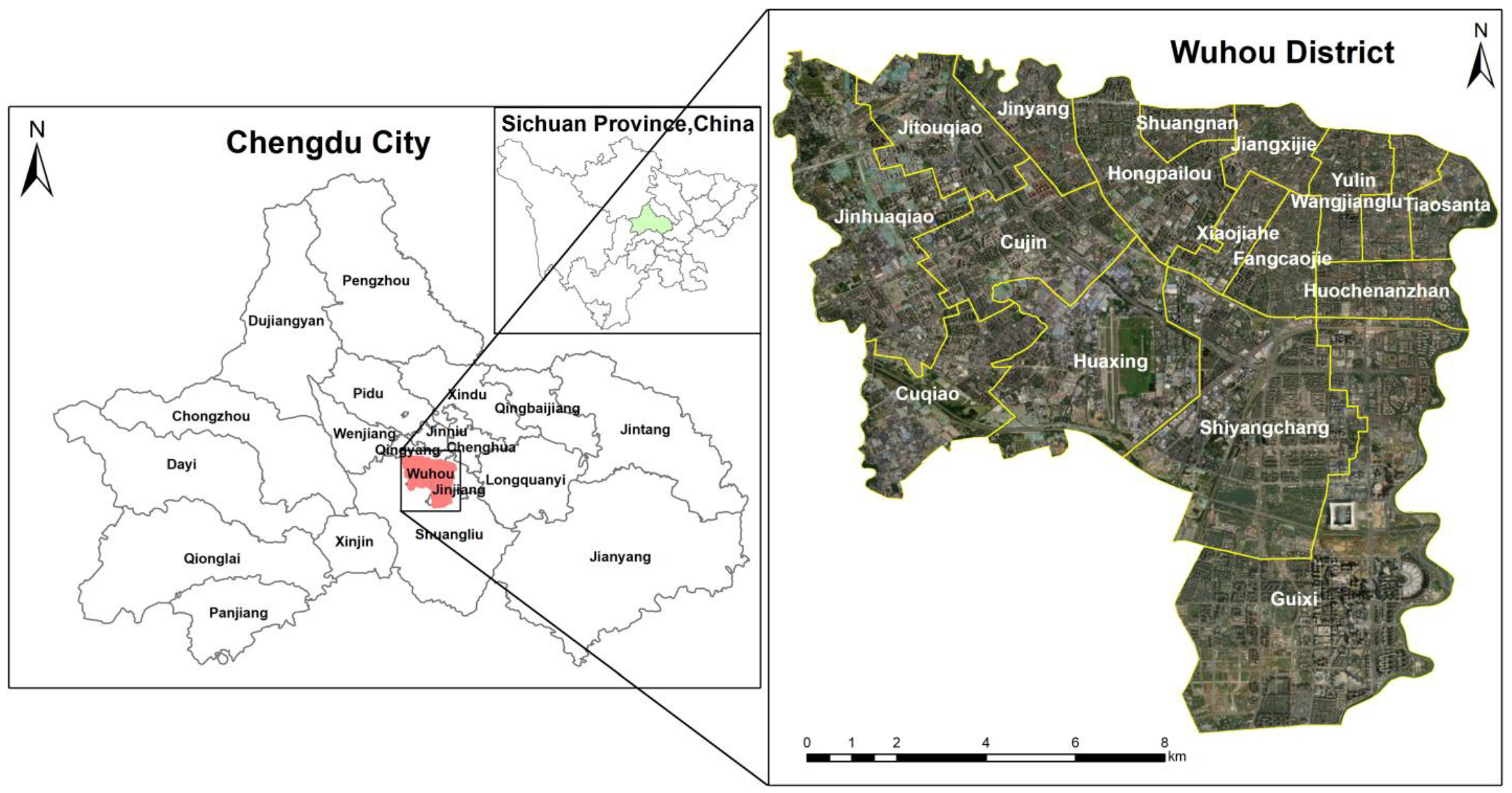
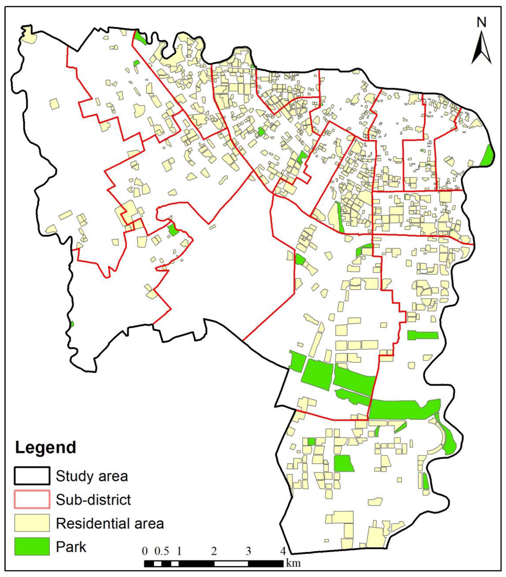
2.1. Study Area
2.2. Data Sources
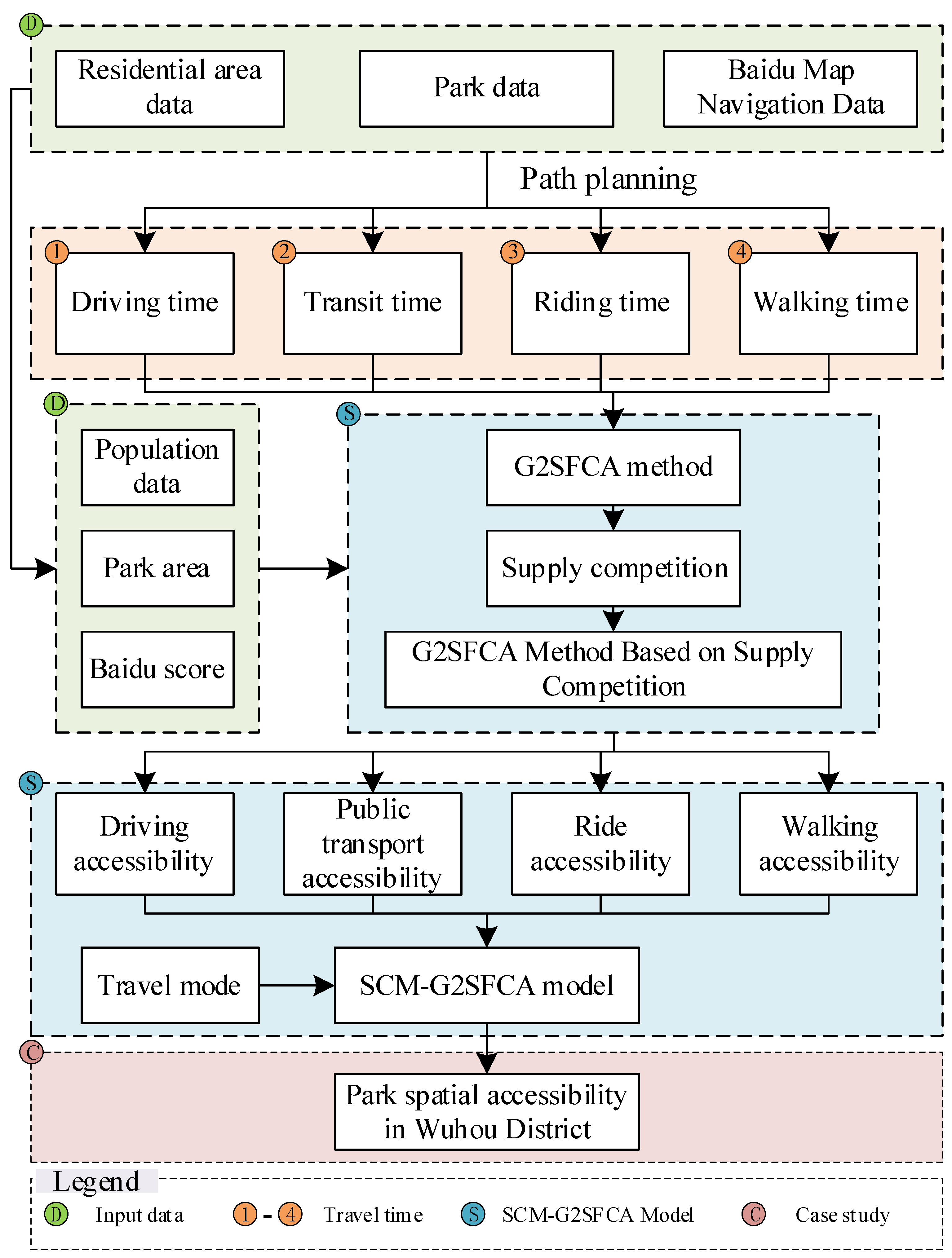
2.3. Methods
2.3.1. G2SFCA Method
2.3.2. G2SFCA Method Based on Supply Competition
2.3.3. SCM-G2SFCA Model
3. Results
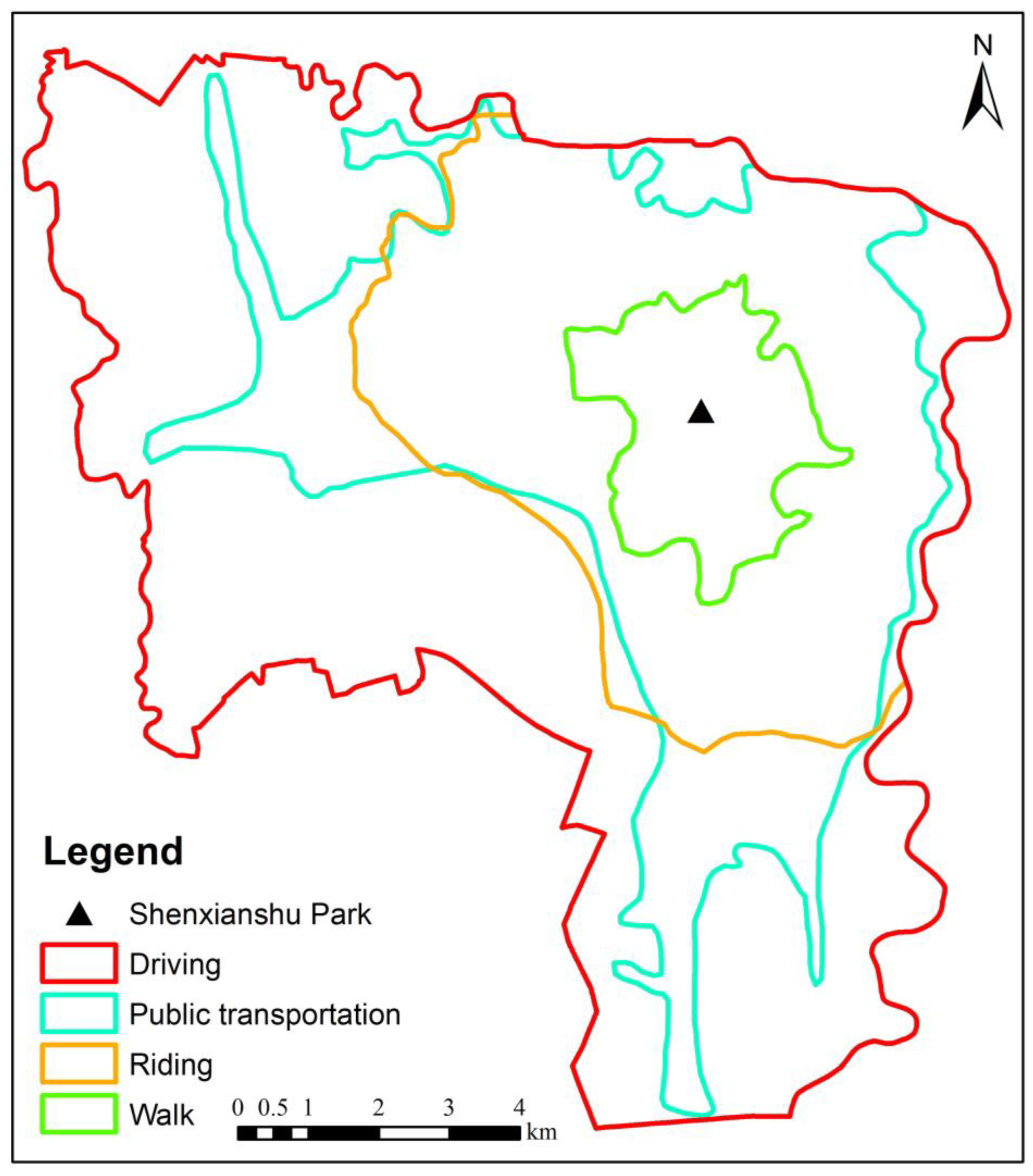
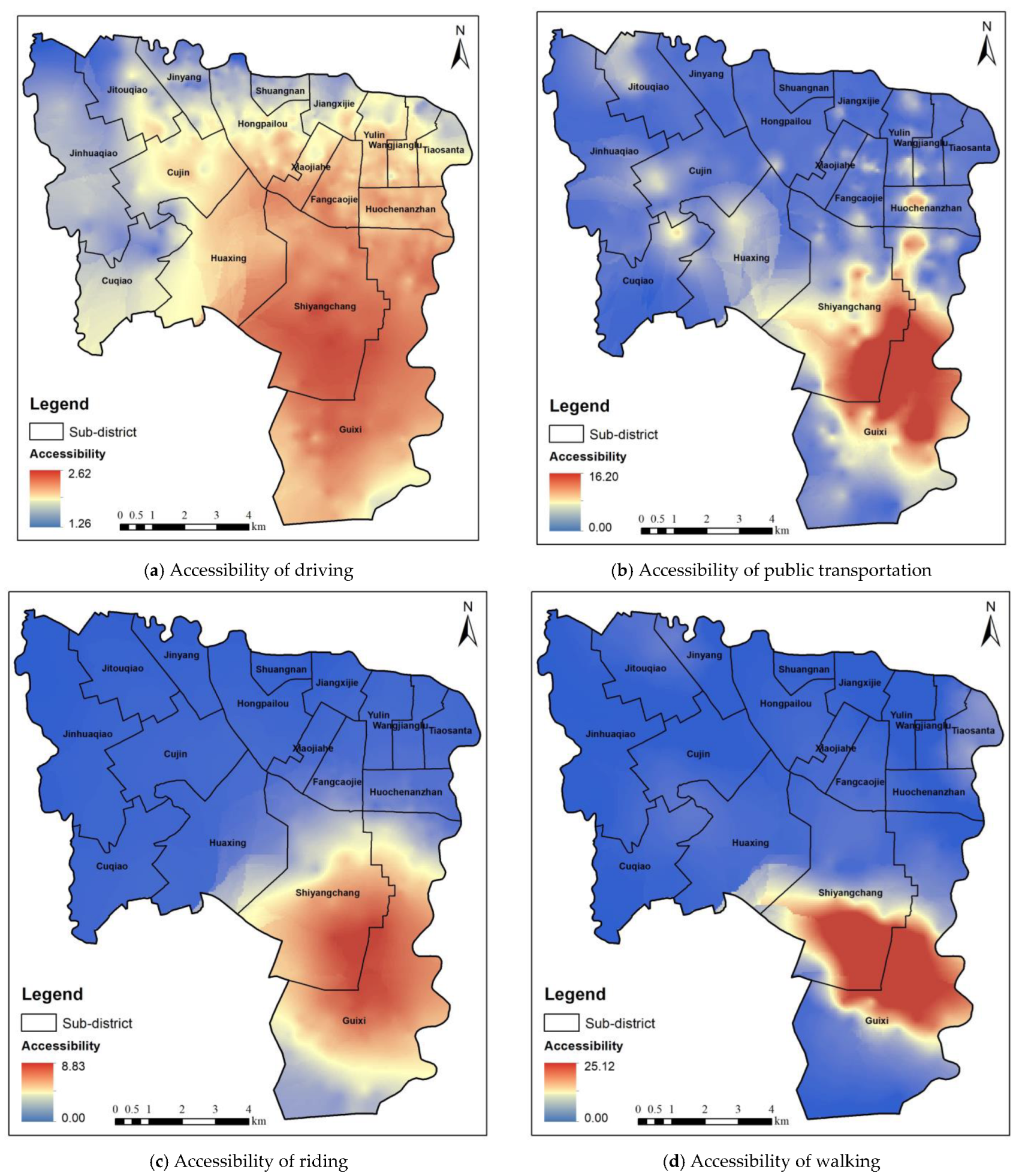
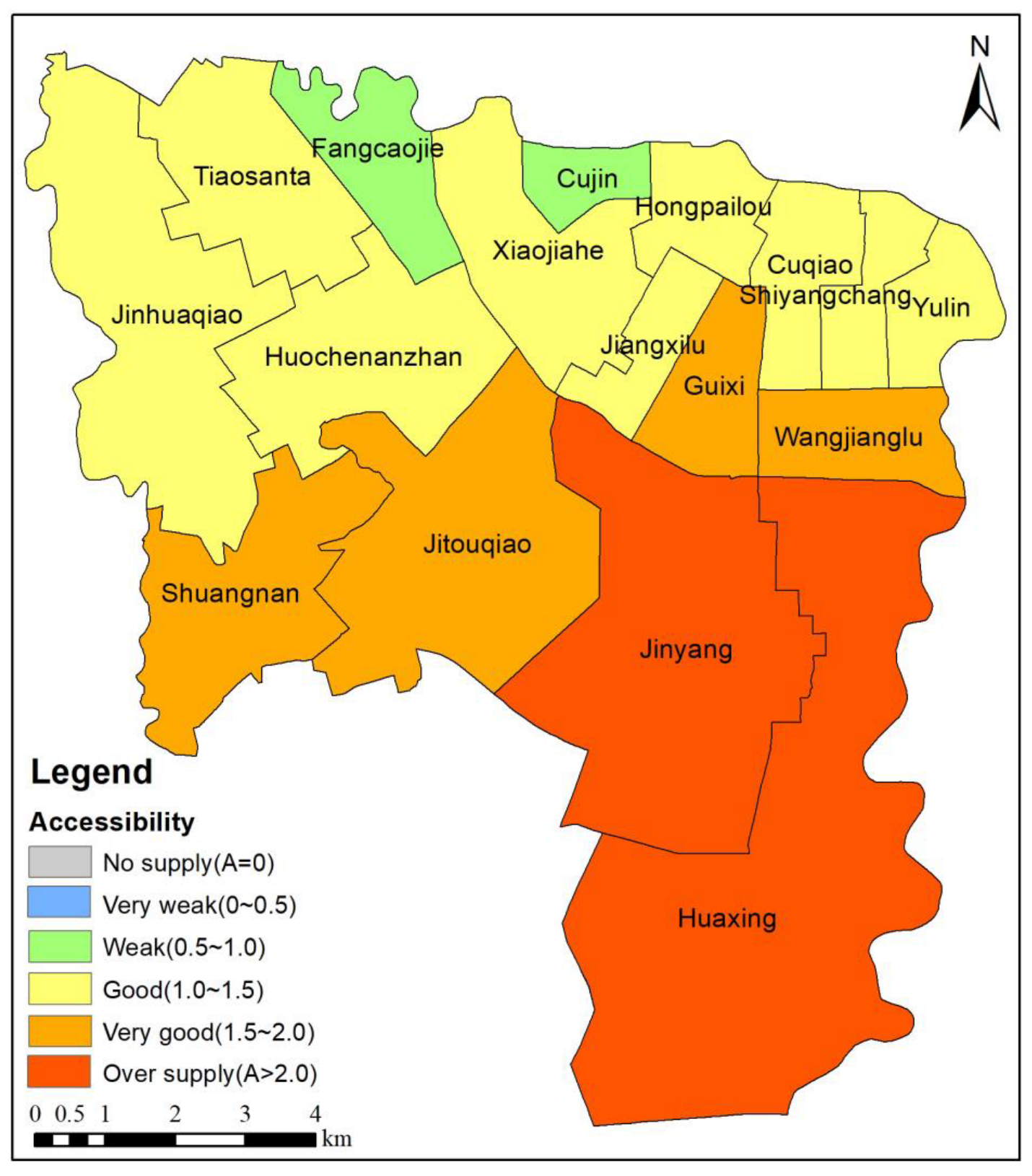
3.1. Park Spatial Accessibility Analysis of a Single Mode Based on the Supply Competition G2SFCA Method
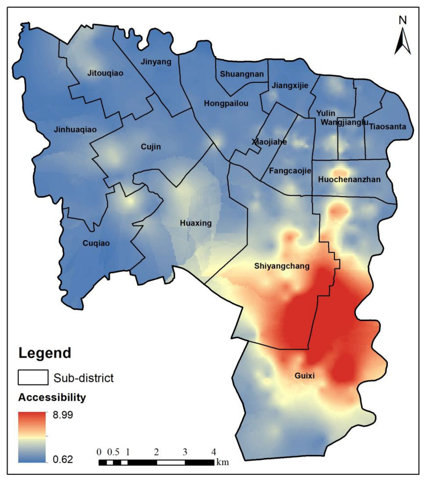
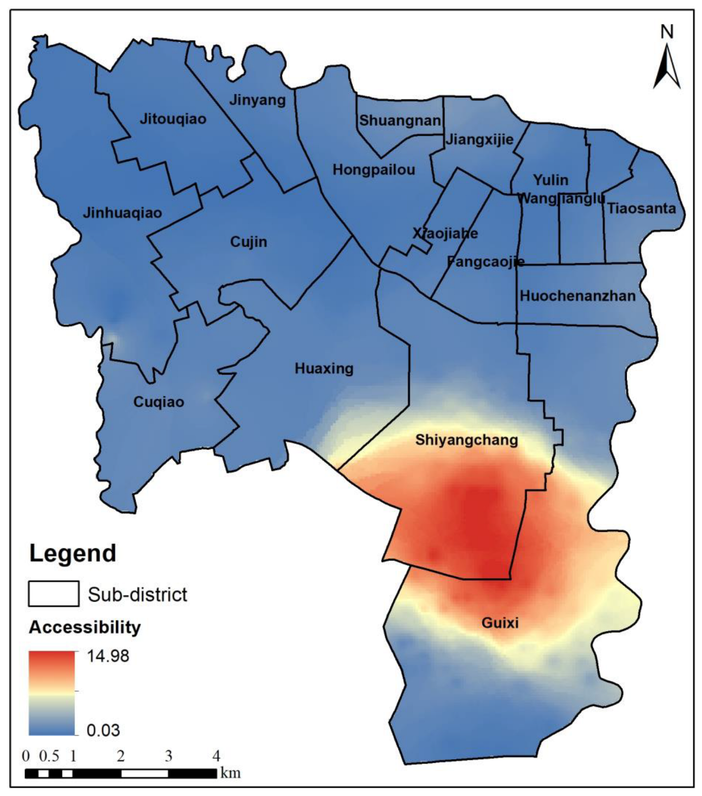
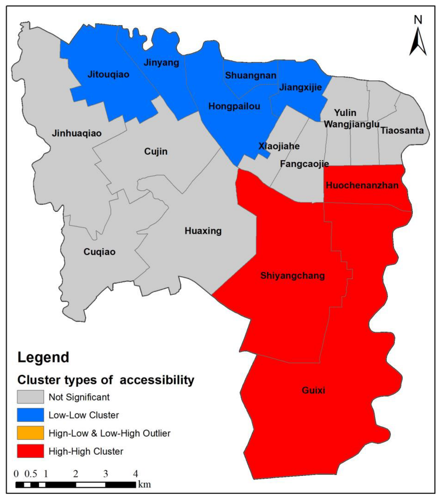
3.2. Analysis of Park Spatial Accessibility Based on the SCM-G2SFCA Model
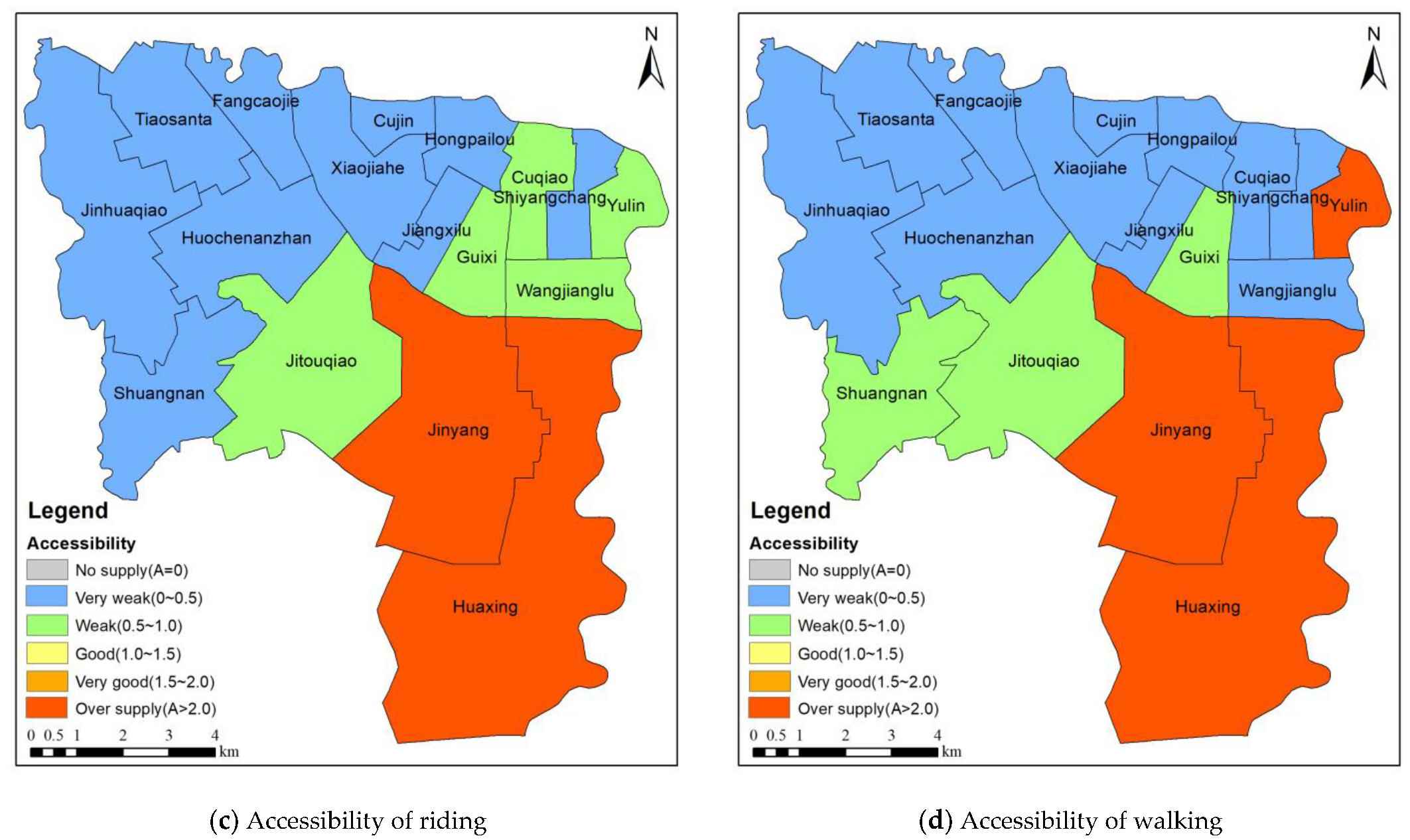
3.3. Park Spatial Accessibility Analysis of Sub-Districts in the Wuhou District
4. Conclusions
Author Contributions
Funding
Institutional Review Board Statement
Informed Consent Statement
Data Availability Statement
Acknowledgments
Conflicts of Interest
References
- Sadeghian, M.M.; Vardanyan, Z. The Benefits of Urban Parks, a Review of Urban Research. J. Nov. Appl. Sci. 2013, 7. [Google Scholar]
- Park, H.-M.; Jo, H.-K. Ecological Design and Construction Strategies through Life Cycle Assessment of Carbon Budget for Urban Parks in Korea. Forests 2021, 12, 1399. [Google Scholar] [CrossRef]
- Xie, J.; Luo, S.; Furuya, K.; Sun, D. Urban Parks as Green Buffers During the COVID-19 Pandemic. Sustainability 2020, 12, 6751. [Google Scholar] [CrossRef]
- Song, C.; Ikei, H.; Igarashi, M.; Takagaki, M.; Miyazaki, Y. Physiological and Psychological Effects of a Walk in Urban Parks in Fall. Int. J. Environ. Res. Public Health 2015, 12, 14216–14228. [Google Scholar] [CrossRef]
- Liu, H.; Li, F.; Li, J.; Zhang, Y. The Relationships between Urban Parks, Residents’ Physical Activity, and Mental Health Benefits: A Case Study from Beijing, China. J. Environ. Manag. 2017, 190, 223–230. [Google Scholar] [CrossRef]
- Seo, S.; Choi, S.; Kim, K.; Kim, S.M.; Park, S.M. Association between Urban Green Space and the Risk of Cardiovascular Disease: A Longitudinal Study in Seven Korean Metropolitan Areas. Environ. Int. 2019, 125, 51–57. [Google Scholar] [CrossRef] [PubMed]
- Park, S.; Lee, J.; Kang, D.Y.; Rhee, C.W.; Park, B.-J. Indoor Physical Activity Reduces All-Cause and Cardiovascular Disease Mortality Among Elderly Women. J. Prev. Med. Public Health 2012, 45, 21–28. [Google Scholar] [CrossRef]
- Sanchis-Gomar, F.; Lavie, C.J.; Marín, J.; Perez-Quilis, C.; Eijsvogels, T.M.H.; O’Keefe, J.H.; Perez, M.V.; Blair, S.N. Exercise Effects on Cardiovascular Disease: From Basic Aspects to Clinical Evidence. Cardiovasc. Res. 2022, 118, 2253–2266. [Google Scholar] [CrossRef]
- Tan, P.Y.; Samsudin, R. Effects of Spatial Scale on Assessment of Spatial Equity of Urban Park Provision. Landsc. Urban Plan. 2017, 158, 139–154. [Google Scholar] [CrossRef]
- Sun, R.; Li, F.; Chen, L. A Demand Index for Recreational Ecosystem Services Associated with Urban Parks in Beijing, China. J. Environ. Manag. 2019, 251, 109612. [Google Scholar] [CrossRef]
- Taleai, M.; Sliuzas, R.; Flacke, J. An Integrated Framework to Evaluate the Equity of Urban Public Facilities Using Spatial Multi-Criteria Analysis. Cities 2014, 40, 56–69. [Google Scholar] [CrossRef]
- Chiesura, A. The Role of Urban Parks for the Sustainable City. Landsc. Urban Plan. 2004, 68, 129–138. [Google Scholar] [CrossRef]
- Hansen, W.G. How Accessibility Shapes Land Use. J. Am. Inst. Plan. 1959, 25, 73–76. [Google Scholar] [CrossRef]
- Chen, Z.; Li, Y.; Wang, P. Transportation Accessibility and Regional Growth in the Greater Bay Area of China. Transp. Res. Part D Transp. Environ. 2020, 86, 102453. [Google Scholar] [CrossRef]
- Seo, W.; Nam, H.K. Trade-off Relationship between Public Transportation Accessibility and Household Economy: Analysis of Subway Access Values by Housing Size. Cities 2019, 87, 247–258. [Google Scholar] [CrossRef]
- Cui, B.; DeWeese, J.; Wu, H.; King, D.A.; Levinson, D.; El-Geneidy, A. All Ridership Is Local: Accessibility, Competition, and Stop-Level Determinants of Daily Bus Boardings in Portland, Oregon. J. Transp. Geogr. 2022, 99, 103294. [Google Scholar] [CrossRef]
- Hou, G.; Chen, S.; Bao, Y. Development of Travel Time Functions for Disrupted Urban Arterials with Microscopic Traffic Simulation. Phys. A Stat. Mech. Its Appl. 2022, 593, 126961. [Google Scholar] [CrossRef]
- Tao, Z.; Cheng, Y. Research Progress of the Two-Step Floating Catchment Area Method and Extensions. Prog. Geogr. 2016, 35, 589–599. [Google Scholar] [CrossRef]
- Luo, W.; Qi, Y. An Enhanced Two-Step Floating Catchment Area (E2SFCA) Method for Measuring Spatial Accessibility to Primary Care Physicians. Health Place 2009, 15, 1100–1107. [Google Scholar] [CrossRef]
- Tao, Z.; Cheng, Y.; Dai, T.; Rosenberg, M.W. Spatial Optimization of Residential Care Facility Locations in Beijing, China: Maximum Equity in Accessibility. Int. J. Health Geogr. 2014, 13, 33. [Google Scholar] [CrossRef]
- Dai, D. Racial/Ethnic and Socioeconomic Disparities in Urban Green Space Accessibility: Where to Intervene? Landsc. Urban Plan. 2011, 102, 234–244. [Google Scholar] [CrossRef]
- Dai, D. Black Residential Segregation, Disparities in Spatial Access to Health Care Facilities, and Late-Stage Breast Cancer Diagnosis in Metropolitan Detroit. Health Place 2010, 16, 1038–1052. [Google Scholar] [CrossRef] [PubMed]
- Dai, D.; Wang, F. Geographic Disparities in Accessibility to Food Stores in Southwest Mississippi. Environ. Plann. B 2011, 38, 659–677. [Google Scholar] [CrossRef]
- Wang, F. Measurement, Optimization, and Impact of Health Care Accessibility: A Methodological Review. Ann. Assoc. Am. Geogr. 2012, 102, 1104–1112. [Google Scholar] [CrossRef] [PubMed]
- Luo, W.; Whippo, T. Variable Catchment Sizes for the Two-Step Floating Catchment Area (2SFCA) Method. Health Place 2012, 18, 789–795. [Google Scholar] [CrossRef]
- McGrail, M.R.; Humphreys, J.S. Measuring Spatial Accessibility to Primary Health Care Services: Utilising Dynamic Catchment Sizes. Appl. Geogr. 2014, 54, 182–188. [Google Scholar] [CrossRef]
- Wan, N.; Zou, B.; Sternberg, T. A Three-Step Floating Catchment Area Method for Analyzing Spatial Access to Health Services. Int. J. Geogr. Inf. Sci. 2012, 26, 1073–1089. [Google Scholar] [CrossRef]
- Luo, J. Integrating the Huff Model and Floating Catchment Area Methods to Analyze Spatial Access to Healthcare Services: Analyzing Spatial Access to Healthcare Services. Trans. GIS 2014, 18, 436–448. [Google Scholar] [CrossRef]
- Shao, Y.; Luo, W. Supply-Demand Adjusted Two-Steps Floating Catchment Area (SDA-2SFCA) Model for Measuring Spatial Access to Health Care. Soc. Sci. Med. 2022, 296, 114727. [Google Scholar] [CrossRef]
- Fransen, K.; Neutens, T.; De Maeyer, P.; Deruyter, G. A Commuter-Based Two-Step Floating Catchment Area Method for Measuring Spatial Accessibility of Daycare Centers. Health Place 2015, 32, 65–73. [Google Scholar] [CrossRef]
- Hu, S.; Song, W.; Li, C.; Lu, J. A Multi-Mode Gaussian-Based Two-Step Floating Catchment Area Method for Measuring Accessibility of Urban Parks. Cities 2020, 105, 102815. [Google Scholar] [CrossRef]
- Zhang, F.; Li, D.; Ahrentzen, S.; Zhang, J. Assessing Spatial Disparities of Accessibility to Community-Based Service Resources for Chinese Older Adults Based on Travel Behavior: A City-Wide Study of Nanjing, China. Habitat Int. 2019, 88, 101984. [Google Scholar] [CrossRef]
- Li, Z.; Fan, Z.; Song, Y.; Chai, Y. Assessing Equity in Park Accessibility Using a Travel Behavior-Based G2SFCA Method in Nanjing, China. J. Transp. Geogr. 2021, 96, 103179. [Google Scholar] [CrossRef]
- Wang, S.; Wang, M.; Liu, Y. Access to Urban Parks: Comparing Spatial Accessibility Measures Using Three GIS-Based Approaches. Comput. Environ. Urban Syst. 2021, 90, 101713. [Google Scholar] [CrossRef]
- Zhou, N. Impact of residential environment on commuting style under low carbon travel guidance. Shanxi Archit. 2019, 45, 10–12. [Google Scholar] [CrossRef]
- Radke, J.; Mu, L. Spatial Decompositions, Modeling and Mapping Service Regions to Predict Access to Social Programs. Ann. GIS 2000, 6, 105–112. [Google Scholar] [CrossRef]
- Luo, W.; Wang, F. Measures of Spatial Accessibility to Health Care in a GIS Environment: Synthesis and a Case Study in the Chicago Region. Env. Plan. B Plan. Des. 2003, 30, 865–884. [Google Scholar] [CrossRef]


| Travel Mode | Driving | Public Transportation | Riding | Walking |
|---|---|---|---|---|
| Proportion | 25.7% | 43.2% | 8.6% | 22.5% |
Disclaimer/Publisher’s Note: The statements, opinions and data contained in all publications are solely those of the individual author(s) and contributor(s) and not of MDPI and/or the editor(s). MDPI and/or the editor(s) disclaim responsibility for any injury to people or property resulting from any ideas, methods, instructions or products referred to in the content. |
© 2022 by the authors. Licensee MDPI, Basel, Switzerland. This article is an open access article distributed under the terms and conditions of the Creative Commons Attribution (CC BY) license (https://creativecommons.org/licenses/by/4.0/).
Share and Cite
Zhou, Z.; Zhang, X.; Li, M.; Wang, X. An SCM-G2SFCA Model for Studying Spatial Accessibility of Urban Parks. Int. J. Environ. Res. Public Health 2023, 20, 714. https://doi.org/10.3390/ijerph20010714
Zhou Z, Zhang X, Li M, Wang X. An SCM-G2SFCA Model for Studying Spatial Accessibility of Urban Parks. International Journal of Environmental Research and Public Health. 2023; 20(1):714. https://doi.org/10.3390/ijerph20010714
Chicago/Turabian StyleZhou, Zexu, Xuedong Zhang, Mengwei Li, and Xuedi Wang. 2023. "An SCM-G2SFCA Model for Studying Spatial Accessibility of Urban Parks" International Journal of Environmental Research and Public Health 20, no. 1: 714. https://doi.org/10.3390/ijerph20010714
APA StyleZhou, Z., Zhang, X., Li, M., & Wang, X. (2023). An SCM-G2SFCA Model for Studying Spatial Accessibility of Urban Parks. International Journal of Environmental Research and Public Health, 20(1), 714. https://doi.org/10.3390/ijerph20010714