
Study on the Optimization of Territory Spatial “Urban–Agricultural–Ecological” Pattern Based on the Improvement of “Production–Living–Ecological” Function under Carbon Constraint


Abstract
:1. Introduction
2. Materials and Methods
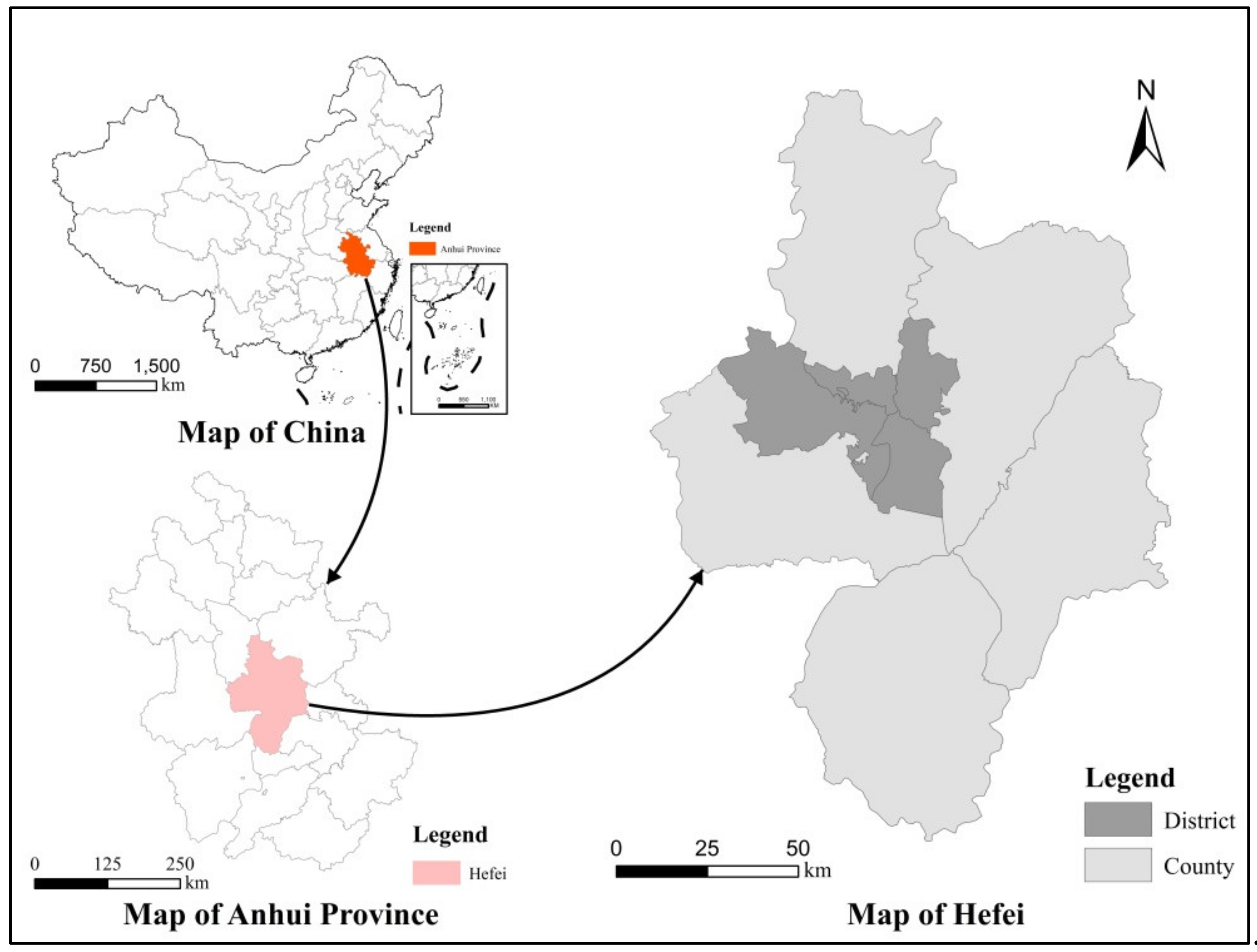
2.1. Study Area
2.2. Data Sources
2.3. Modified Constraint Evaluation Model
2.4. Normalized Revealed Comparative Advantage Index
2.5. FLUS Model
2.5.1. Occurrence Probability
2.5.2. Neighborhood Effects
2.5.3. Self-Adaptive Inertia Coefficient
2.5.4. Conversion Cost
3. Results
3.1. Evolution of Land Use Structure and UAE Pattern
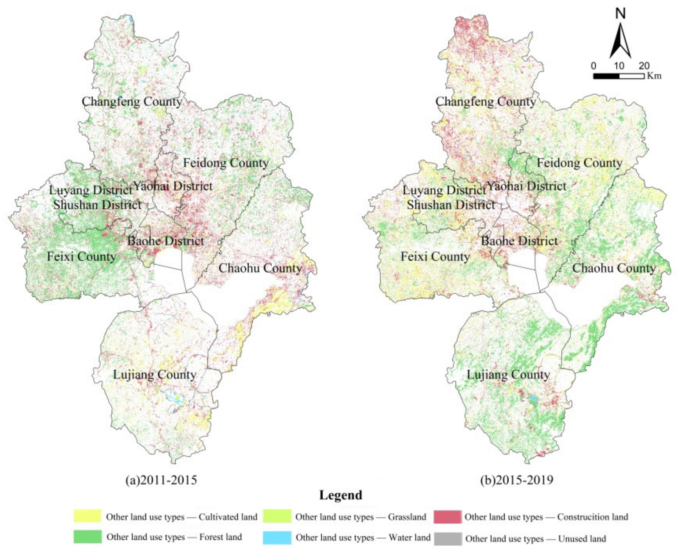
3.1.1. Evolution of Land use Structure
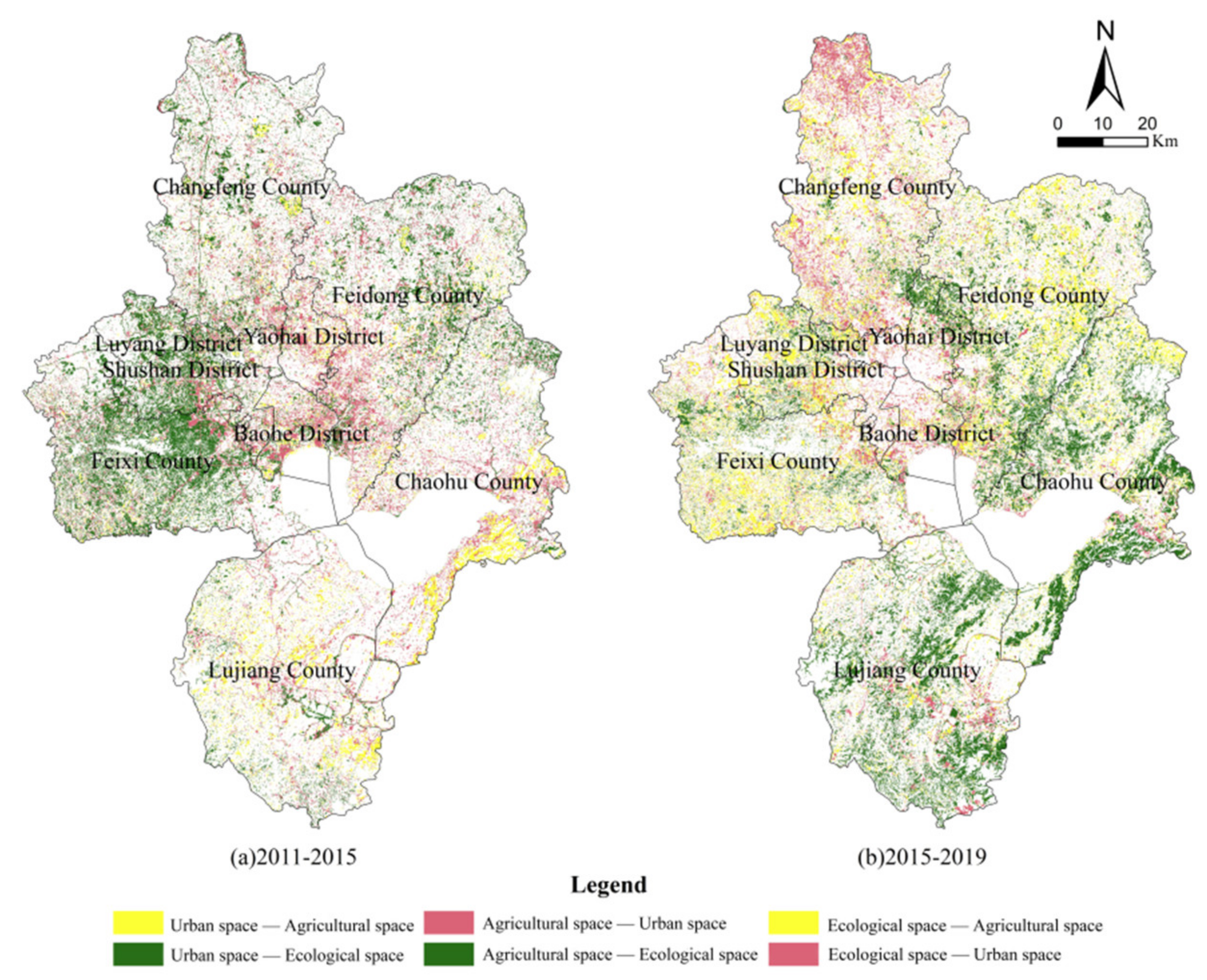
3.1.2. Evolution of UAE Pattern
3.2. Evaluation and Advantage Discrimination of PLE Function under Carbon Constraint
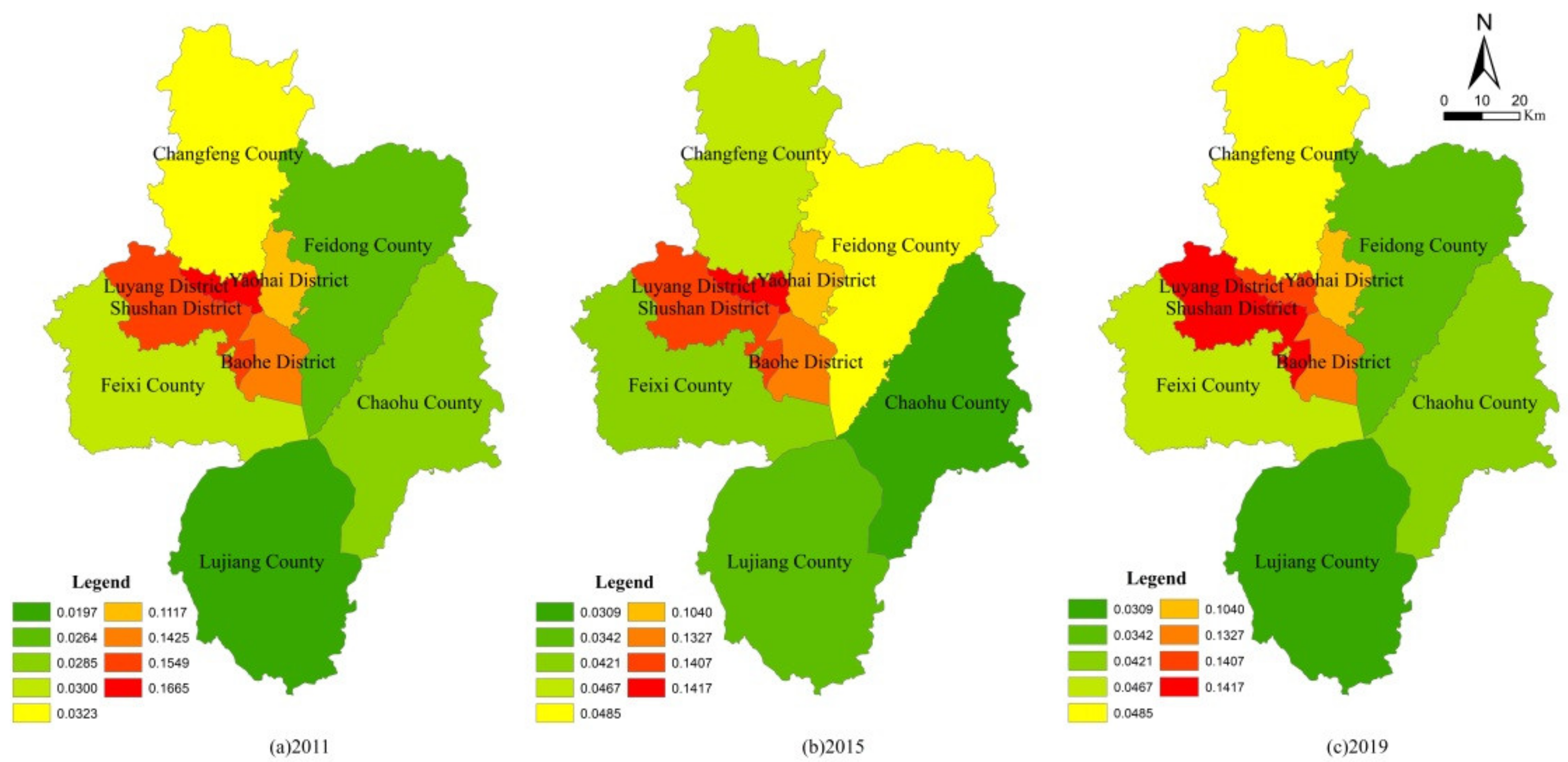
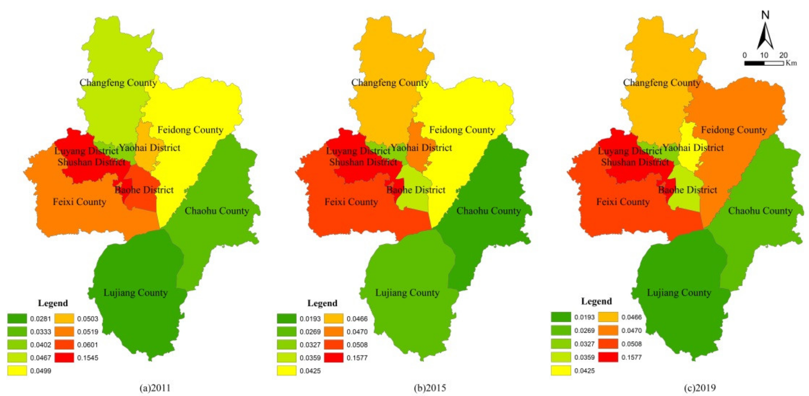
3.2.1. Evolution of PLE Function under Carbon Constraint
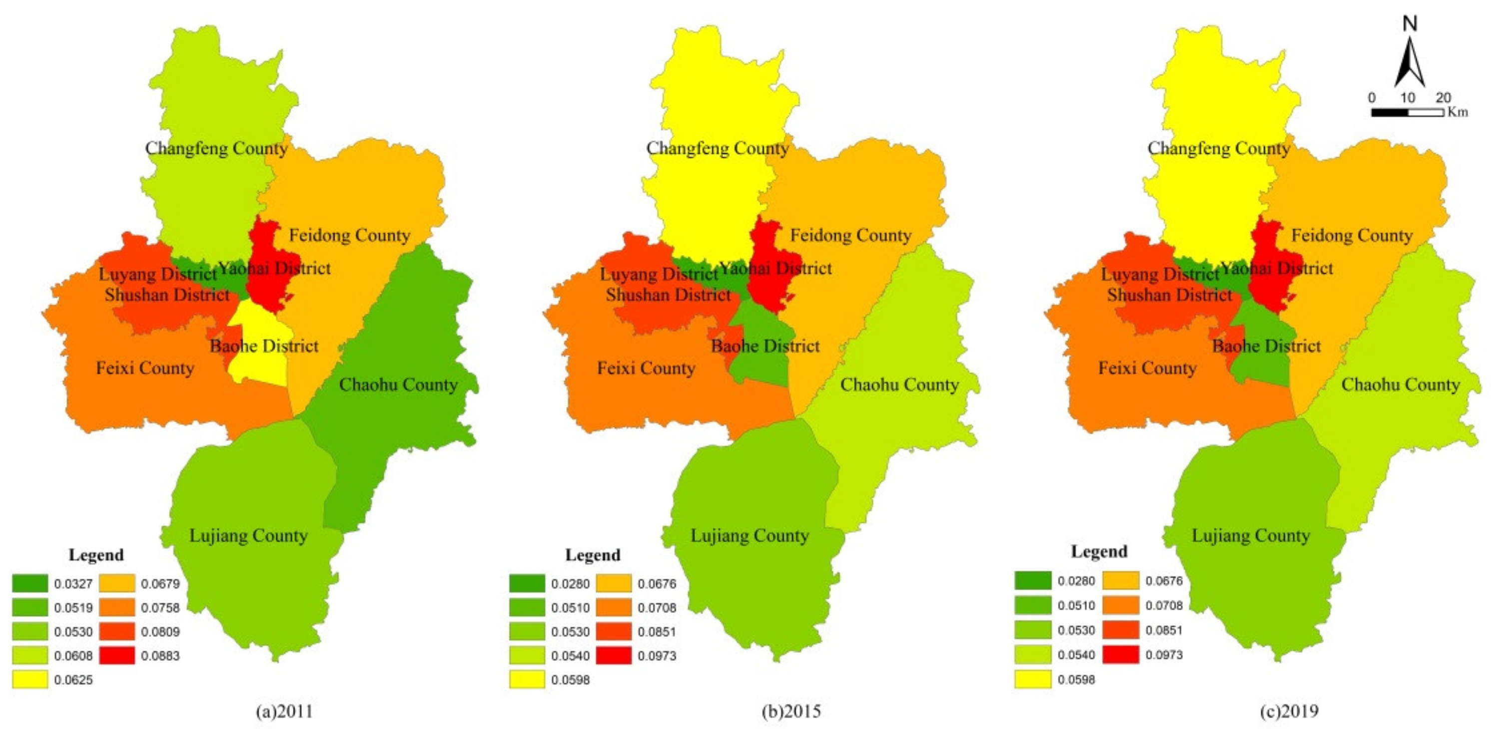
3.2.2. Advantage Discrimination of PLE Function
3.3. Simulation of Territory Spatial UAE Pattern
3.3.1. Neighborhood Effect and Conversion Cost
3.3.2. Precision Inspection
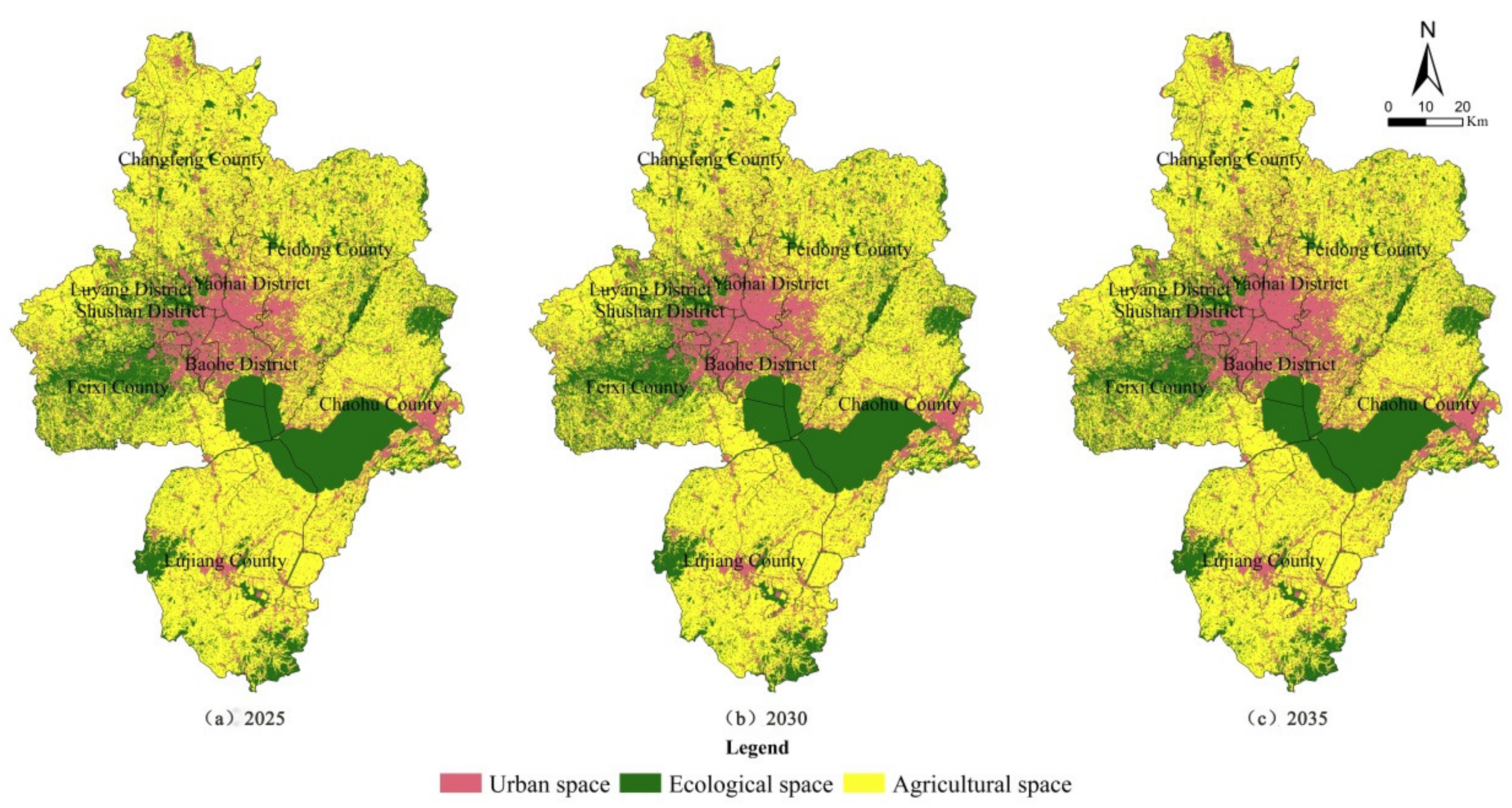
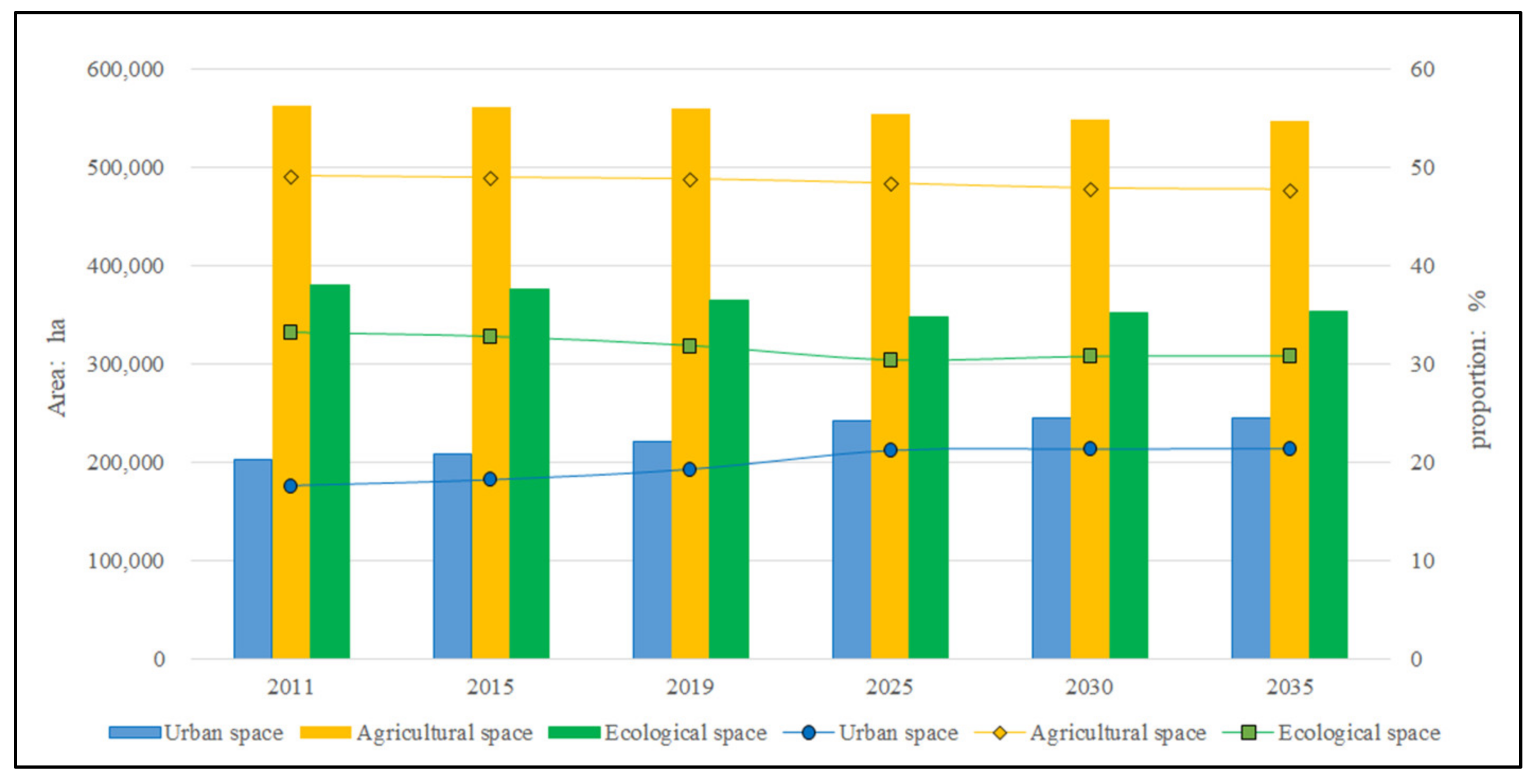
3.3.3. Simulation Results
4. Discussion
5. Conclusions
Author Contributions
Funding
Institutional Review Board Statement
Informed Consent Statement
Data Availability Statement
Conflicts of Interest
References
- Cattivelli, V. Planning peri-urban areas at regional level: The experience of Lombardy and Emilia-Romagna (Italy). Land Use Policy 2021, 103, 105282. [Google Scholar] [CrossRef]
- Fox, D.M.; Carrega, P.; Ren, Y.; Caillouet, P.; Bouillon, C.; Robrt, S. How wildfire risk is related to urban planning and Fire Weather Index in SE France (1990–2013). Sci. Total Environ. 2018, 621, 120–129. [Google Scholar] [CrossRef] [PubMed]
- Maleki, J.; Masoumi, Z.; Hakimpourc, F.; Coello, C.A. A spatial land-use planning support system based on game theory. Land Use Policy 2020, 99, 105013. [Google Scholar] [CrossRef]
- Sánchez, M.L.; Cabrera, A.T.; Gómez Del Pulgar, M.L. Guidelines from the heritage field for the integration of landscape and heritage planning: A systematic literature review. Landsc. Urban Plan. 2020, 204, 103931. [Google Scholar] [CrossRef]
- Mukherjee, T.; Sharma, V.; Sharma, L.K.; Thakur, M.; Joshi, B.D.; Sharief, A.; Thapa, A.; Dutta, R.; Dolker, S.; Tripathy, B.; et al. Landscape-level habitat management plan through geometric reserve design for critically endangered Hangul (Cervus hanglu hanglu). Sci. Total Environ. 2021, 777, 146031. [Google Scholar] [CrossRef] [PubMed]
- Lopes, A.S.; Cavalcantea, C.B.; Vale, D.S.; Loureiro, C.F.G. Convergence of planning practices towards LUT integration: Seeking evidences in a developing country. Land Use Policy 2020, 99, 104842. [Google Scholar] [CrossRef]
- Sangawongse, S.; Fisher, R.; Prabudhanitisarn, S. From centralised planning to collaborative urban land use planning: The case of Wat Ket, Chiang Mai, Thailand. Soc. Sci. Humanit. Open 2021, 4, 100154. [Google Scholar] [CrossRef]
- Kaczmarek, I.; Iwaniak, A.; Świetlicka, A.; Piwowarczyk, M.; Nadolny, A. A machine learning approach for integration of spatial development plans based on natural language processing. Sustain. Cities Soc. 2022, 76, 103479. [Google Scholar] [CrossRef]
- Kang, Q.; Guo, Q.X.; Ding, Y.; Zhang, Y. Tradeoffs/synergies analysis of “production-living-ecological” functions in Shanxi province. J. Nat. Resour. 2021, 36, 1195–1207. [Google Scholar] [CrossRef]
- Liu, J.L.; Liu, Y.S.; Li, Y.R. Classification evaluation and spatial-temporal analysis of “production-living-ecological” spaces in China. Acta Geogr. Sin. 2017, 72, 1290–1304. [Google Scholar]
- Liu, P.F.; Sun, B.D. The spatial pattern of urban production-living-ecological space quality and its related factors in China. Geogr. Res. 2020, 39, 13–24. [Google Scholar]
- Li, H.Y. Research on new urbanization coordinated development of Beijing-Tianjin-Hebei City cluster based on the concept of “production-living-ecology” Space. Ecol. Econ. 2021, 37, 92–98. [Google Scholar]
- Tang, J.X.; Liu, Y.J. The evolutionary process and driving mechanism of human settlement environment in typical tourism cities based on living-production-ecological system: A case study of Zhangjiajie city. Geogr. Res. 2021, 40, 1803–1822. [Google Scholar]
- Wang, Q.; Chen, T.T.; Li, A.D.; Zhang, S.C.; Wang, Y.F. Evaluation of territorial utilization quality based on “production-living-ecological” perspectives: A case study of Panxi region. Mt. Res. 2020, 38, 290–302. [Google Scholar]
- Han, M.; Kong, X.L.; Li, Y.L.; Wei, F.; Kong, F.B.; Huang, S.P. Eco-environmental effects and its spatial heterogeneity of ‘ecological-production-living’ land use transformation in the Yellow River Delta. Sci. Geogr. Sin. 2021, 41, 1009–1018. [Google Scholar]
- Wei, W.; Miao, J.B.; Xia, J.N.; Wu, J. Spatial-temporal evolution characteristics and mechanism of “Three-Zone Space” along the Yangtze River Economic Belt in Hubei Province from 2010 to 2017. Econ. Geogr. 2020, 40, 132–142. [Google Scholar]
- Wang, G.Z.; Han, Q.; de Vries, B. The multi-objective spatial optimization of urban land use based on low-carbon city planning. Ecol. Indic. 2021, 125, 107540. [Google Scholar] [CrossRef]
- Chowdhury, S.; Peddle, D.R.; Wulder, M.A.; Heckbert, S.; Shipman, T.C.; Chao, D.K. Estimation of land-use/land-cover changes associated with energy footprints and other disturbance agents in the Upper Peace Region of Alberta Canada from 1985 to 2015 using Landsat data. Int. J. Appl. Earth Obs. Geoinf. 2021, 94, 102224. [Google Scholar] [CrossRef]
- Yu, R.; Tian, S.M. An analysis of land use and carbon emission in Hefei city based on carrying relationship. J. Anhui Agric. Univ. 2016, 43, 939–945. [Google Scholar]
- Hu, X.D.; Wang, Z.Q.; Tong, Q.Y.; Li, D.S. The regional land consolidation and rehabilitation potential evaluation under the constraints of ecology and socio-economy. Resour. Environ. Yangtze Basin 2016, 25, 804–812. [Google Scholar]
- Wu, J.R.; Chen, X.L.; Lu, J.Z. Assessment of long and short-term flood risk using the multi-criteria analysis model with the AHP-Entropy method in Poyang Lake basin. Int. J. Disaster Risk Reduct. 2022, 75, 102968. [Google Scholar] [CrossRef]
- Balassa, B. Trade Liberalization and “Revealed” Comparative Advantage. Manch. Sch. 1965, 33, 99–123. [Google Scholar] [CrossRef]
- Yu, R.; Cai, J.N.; Leung, P.S. The normalized Revealed Comparative Advantage Index. Ann. Reg. Sci. 2009, 43, 267–282. [Google Scholar] [CrossRef]
- Liu, X.P.; Liang, X.; Li, X.; Xu, X.C.; Ou, J.P.; Chen, Y.M.; Li, S.Y.; Wang, S.J.; Pei, F.S. A future land use simulation model (FLUS) for simulating multiple land use scenarios by coupling human and natural effects. Landsc. Urban Plan. 2017, 168, 94–116. [Google Scholar] [CrossRef]
- Liang, X.; Liu, X.P.; Li, D.; Zhao, H.; Chen, G.Z. Urban growth simulation by incorporating planning policies into a CA-based future land-use simulation model. Int. J. Geogr. Inf. Sci. 2018, 32, 2294–2316. [Google Scholar] [CrossRef]
- Xu, L.; Dong, J.; Li, L.; Zhang, J.F. Characteristics and optimization of geographical space in urban agglomeration in the middle reaches of the Yangtze River based on the function zoning. Econ. Geogr. 2017, 37, 76–83. [Google Scholar]
- Zou, L.L.; Li, Y.R.; Liu, Y.S.; Wang, J.Y. Theory building and empirical research of production-living-ecological function of cultivated land based on the elements. Geogr. Res. 2021, 40, 839–855. [Google Scholar]
- Ke, X.L.; Xiao, B.Y.; Zheng, W.W.; Ma, Y.C.; Li, H.Y. Urban-agricultural-ecological Space Zoning based on Scenario Simulation. J. Geo-Inf. Sci. 2020, 22, 580–591. [Google Scholar]


| Land Use Type | 2011 | 2015 | 2019 | 2011–2019 | ||||
|---|---|---|---|---|---|---|---|---|
| Area/ha | Proportion/% | Area/ha | Proportion/% | Area/ha | Proportion/% | Change Value /ha | Amplitude of Variation/% | |
| Cultivated land | 561,796.27 | 49.09 | 560,457.18 | 48.97 | 558,840.00 | 48.83 | −2956.27 | −0.26 |
| Forest land | 113,574.21 | 9.92 | 113,248.66 | 9.89 | 112,381.12 | 9.82 | −1193.09 | −0.10 |
| Grassland | 6855.75 | 0.60 | 6460.29 | 0.56 | 6344.24 | 0.55 | −511.51 | −0.05 |
| Water area | 238,074.63 | 20.80 | 234,523.50 | 20.49 | 225,450.00 | 19.70 | −12,624.63 | −1.10 |
| Construction land | 203,126.54 | 17.75 | 208,636.83 | 18.23 | 220,865.00 | 19.30 | 17,738.46 | 1.55 |
| Unused land | 21,078.83 | 1.84 | 21,179.77 | 1.85 | 20,625.87 | 1.80 | −452.96 | −0.04 |
| Transferred from 2011 to 2015/ha | Transferred from 2015 to 2019/ha | Transferred from 2011 to 2019/ha | ||||||||||
|---|---|---|---|---|---|---|---|---|---|---|---|---|
| Urban Space | Agricultural Space | Ecological Space | Subtotal | Urban Space | Agricultural Space | Ecological Space | Subtotal | Urban Space | Agricultural Space | Ecological Space | Total | |
| Urban space | 0 | 3176.47 | 1308.58 | 4485.05 | 0 | 4993.25 | 2382.77 | 7376.02 | 0 | 8169.72 | 3691.35 | 11,861.07 |
| Agricultural space | 9328.41 | 0 | 12,804.5 | 22,132.91 | 5559.01 | 0 | 11,918.98 | 17,477.99 | 14,887.42 | 0 | 24,723.48 | 39,610.90 |
| Ecological space | 1564.29 | 3236.95 | 0 | 4801.24 | 2766.87 | 6853.74 | 0 | 9620.61 | 4331.16 | 10,090.69 | 0 | 14,421.85 |
| Level I Index | First-Order Weight | Secondary Indexes | Unit | Direction | Secondary Weight | Three-Level Weight | W(A,Tc) |
|---|---|---|---|---|---|---|---|
| Production function | 0.2667 | Gross output value of agriculture, forestry and fishery | CNY one hundred million | + | 0.0767 | 0.0205 | 0.0181 |
| Grain yield per unit area | t/ha | + | 0.0436 | 0.0116 | 0.0150 | ||
| Meat output per capita | Kg/person | + | 0.0885 | 0.0236 | 0.0197 | ||
| Industrial added value | CNY one hundred million | + | 0.0496 | 0.0132 | 0.0208 | ||
| Total profits of enterprises above designated size | CNY one hundred million | + | 0.1107 | 0.0295 | 0.0253 | ||
| Floor space of buildings completed | m2 | + | 0.0559 | 0.0149 | 0.0170 | ||
| Post and telecommunications business income | CNY one hundred million | + | 0.0456 | 0.0122 | 0.0225 | ||
| fixed-asset investment | CNY one hundred million | + | 0.0607 | 0.0162 | 0.0190 | ||
| Economic density | Ten thousand CNY/km2 | + | 0.1141 | 0.0304 | 0.0266 | ||
| Value of import and export | USD one hundred million | + | 0.1760 | 0.0469 | 0.0397 | ||
| Amount of foreign capital utilized | USD one hundred million | + | 0.1786 | 0.0476 | 0.0431 | ||
| living function | 0.2667 | Population urbanization rate | % | + | 0.1629 | 0.0434 | 0.0423 |
| Per capita GDP | CNY/person | + | 0.1056 | 0.0282 | 0.0255 | ||
| Total retail sales of social consumer goods per capita | CNY/person | + | 0.1807 | 0.0482 | 0.0461 | ||
| Average wage of employees on the job | CNY | + | 0.1027 | 0.0274 | 0.0303 | ||
| Per capita savings deposit balance | Ten thousand CNY/person | + | 0.2035 | 0.0543 | 0.0549 | ||
| Education expenditure ratio | % | + | 0.0390 | 0.0104 | 0.0171 | ||
| Per capita residential land area | m2/person | + | 0.0634 | 0.0169 | 0.0197 | ||
| Number of beds in health Institutions owned by 10,000 people | Zhang/10,000 people | + | 0.1423 | 0.0380 | 0.0307 | ||
| ecological function | 0.2667 | Per capita park and green areas | m2/person | + | 0.0943 | 0.0251 | 0.0289 |
| Ground average discharge of industrial wastewater | t/m2 | - | 0.0993 | 0.0265 | 0.0255 | ||
| Ground average emission of industrial SO2 | t/m2 | - | 0.1101 | 0.0294 | 0.0197 | ||
| Ground average amount of chemical fertilizer | t/km2 | - | 0.1548 | 0.0413 | 0.0346 | ||
| Comprehensive utilization rate of industrial waste | % | - | 0.1231 | 0.0328 | 0.0541 | ||
| Per capita water resources | m3/person | - | 0.4184 | 0.1116 | 0.1038 | ||
| carbon constraint | 0.1999 | Per capita carbon emission | tC/a | - | 0.1024 | 0.0205 | 0.0195 |
| Ground average intensity of carbon emission | tC/ha | - | 0.0800 | 0.0160 | 0.0156 | ||
| Energy consumption per unit of GDP | kg/CNY ten thousand | - | 0.0924 | 0.0185 | 0.0211 | ||
| Proportion of carbon sinks in terrestrial ecosystems | % | + | 0.5744 | 0.1149 | 0.1073 | ||
| Carbon sink land ratio | % | + | 0.1508 | 0.0302 | 0.0366 |
| Districts or Counties | 2011 | 2015 | 2019 | ||||||
|---|---|---|---|---|---|---|---|---|---|
| Tc | F | Tc | F | Tc | F | ||||
| Yaohai District | 0.6574 | 0.4148 | 0.3296 | 0.6615 | 0.4125 | 0.3279 | 0.6440 | 0.4151 | 0.3308 |
| Luyang District | 0.3824 | 0.3310 | 0.2948 | 0.3611 | 0.2754 | 0.2554 | 0.3444 | 0.2896 | 0.2667 |
| Shushan District | 0.2759 | 0.4979 | 0.4335 | 0.2709 | 0.4873 | 0.4261 | 0.2704 | 0.5002 | 0.4363 |
| Baohe District | 0.3840 | 0.3669 | 0.3206 | 0.3591 | 0.2985 | 0.2725 | 0.3776 | 0.2887 | 0.2644 |
| Changfeng County | 0.3540 | 0.1892 | 0.1920 | 0.3533 | 0.2072 | 0.2053 | 0.2848 | 0.1972 | 0.1978 |
| Feidong County | 0.3850 | 0.1998 | 0.1998 | 0.3751 | 0.2181 | 0.2132 | 0.3063 | 0.1914 | 0.1934 |
| Feixi County | 0.3894 | 0.2190 | 0.2137 | 0.4048 | 0.2300 | 0.2214 | 0.3814 | 0.2296 | 0.2214 |
| Lujiang County | 0.3845 | 0.1395 | 0.1563 | 0.3506 | 0.1540 | 0.1660 | 0.3502 | 0.1334 | 0.1507 |
| Chaohu County | 0.6636 | 0.1892 | 0.1935 | 0.7364 | 0.1809 | 0.1890 | 0.4234 | 0.1730 | 0.1811 |
| Districts or Counties | 2011 | 2015 | 2019 | Advantage function | ||||||
|---|---|---|---|---|---|---|---|---|---|---|
| NRCAp | NRCAl | NRCAe | NRCAp | NRCAl | NRCAe | NRCAp | NRCAl | NRCAe | ||
| Yaohai District | −0.0118 | 0.0070 | 0.0048 | −0.0104 | 0.0008 | 0.0096 | −0.0147 | 0.0082 | 0.0066 | comprehensive |
| Luyang District | −0.0157 | 0.0399 | −0.0242 | −0.0117 | 0.0333 | −0.0215 | −0.0162 | 0.0383 | −0.0222 | living |
| Shushan District | 0.0238 | 0.0003 | −0.0241 | 0.0325 | −0.0101 | −0.0225 | 0.0279 | 0.0041 | −0.0320 | comprehensive |
| Baohe District | −0.0087 | 0.0209 | −0.0122 | −0.0125 | 0.0241 | −0.0116 | −0.0122 | 0.0261 | −0.0138 | living |
| Changfeng County | 0.0037 | −0.0128 | 0.0090 | 0.0036 | −0.0094 | 0.0058 | 0.0039 | −0.0127 | 0.0089 | production–ecological |
| Feidong County | 0.0048 | −0.0170 | 0.0122 | 0.0005 | −0.0097 | 0.0093 | 0.0056 | −0.0204 | 0.0148 | production–ecological |
| Feixi County | 0.0038 | −0.0180 | 0.0142 | 0.0044 | −0.0146 | 0.0101 | 0.0086 | −0.0199 | 0.0113 | production–ecological |
| Lujiang County | −0.0004 | −0.0112 | 0.0116 | −0.0017 | −0.0074 | 0.0091 | −0.0004 | −0.0117 | 0.0121 | ecological |
| Chaohu County | 0.0005 | −0.0092 | 0.0087 | −0.0046 | −0.0069 | 0.0116 | −0.0025 | −0.0120 | 0.0145 | production–ecological |
| Land Use Type | Cultivated Land | Forest Land | Grassland | Water Area | Construction Land | Unused Land |
|---|---|---|---|---|---|---|
| wk | 0.12 | 0.05 | 0.02 | 0.50 | 1 | 0.02 |
| Comprehensive Function | Living–Ecological Function | Production–Ecological Function | Ecological Function | |||||||||||||||||||||
|---|---|---|---|---|---|---|---|---|---|---|---|---|---|---|---|---|---|---|---|---|---|---|---|---|
| a | b | c | d | e | f | a | b | c | d | e | f | a | b | c | d | e | f | a | b | c | d | e | f | |
| a | 1 | 0 | 0 | 0 | 1 | 0 | 1 | 1 | 1 | 1 | 1 | 0 | 1 | 1 | 1 | 1 | 1 | 1 | 1 | 1 | 1 | 1 | 1 | 1 |
| b | 1 | 1 | 0 | 0 | 1 | 0 | 0 | 1 | 1 | 1 | 1 | 0 | 1 | 1 | 1 | 1 | 1 | 1 | 0 | 1 | 0 | 0 | 0 | 0 |
| c | 1 | 1 | 1 | 1 | 1 | 0 | 0 | 1 | 1 | 1 | 1 | 0 | 1 | 1 | 1 | 1 | 1 | 1 | 0 | 1 | 1 | 1 | 0 | 0 |
| d | 1 | 1 | 0 | 1 | 1 | 0 | 0 | 1 | 1 | 1 | 1 | 0 | 1 | 1 | 1 | 1 | 1 | 1 | 0 | 1 | 0 | 1 | 0 | 0 |
| e | 0 | 0 | 0 | 0 | 1 | 0 | 0 | 0 | 0 | 0 | 1 | 0 | 0 | 0 | 0 | 0 | 1 | 0 | 0 | 0 | 0 | 0 | 1 | 0 |
| f | 1 | 1 | 1 | 1 | 1 | 1 | 1 | 1 | 1 | 1 | 1 | 1 | 1 | 1 | 1 | 1 | 1 | 1 | 1 | 1 | 1 | 1 | 1 | 1 |
| UAE | Land Use Type | 2025 | 2030 | 2035 | |||
|---|---|---|---|---|---|---|---|
| Area/ha | Proportion/% | Area/ha | Proportion/% | Area/ha | Proportion/% | ||
| Urban space | Construction land | 242,691.63 | 21.20 | 244,269.96 | 21.34 | 244,858.33 | 21.39 |
| Agricultural space | Cultivated land | 553,766.02 | 48.38 | 548,050.97 | 47.89 | 546,776.11 | 47.77 |
| Ecological space | Forest land | 105,658.18 | 9.23 | 107,500.56 | 9.39 | 107,977.83 | 9.43 |
| Grassland | 5154.18 | 0.45 | 5328.20 | 0.47 | 5267.65 | 0.46 | |
| Water area | 218,895.48 | 19.13 | 220,150.83 | 19.24 | 220,307.68 | 19.25 | |
| Unused land | 18,340.74 | 1.60 | 19,205.71 | 1.68 | 19,318.64 | 1.69 | |
Publisher’s Note: MDPI stays neutral with regard to jurisdictional claims in published maps and institutional affiliations. |
© 2022 by the authors. Licensee MDPI, Basel, Switzerland. This article is an open access article distributed under the terms and conditions of the Creative Commons Attribution (CC BY) license (https://creativecommons.org/licenses/by/4.0/).
Share and Cite
Yu, R.; Qin, Y.; Xu, Y.; Chuai, X. Study on the Optimization of Territory Spatial “Urban–Agricultural–Ecological” Pattern Based on the Improvement of “Production–Living–Ecological” Function under Carbon Constraint. Int. J. Environ. Res. Public Health 2022, 19, 6149. https://doi.org/10.3390/ijerph19106149
Yu R, Qin Y, Xu Y, Chuai X. Study on the Optimization of Territory Spatial “Urban–Agricultural–Ecological” Pattern Based on the Improvement of “Production–Living–Ecological” Function under Carbon Constraint. International Journal of Environmental Research and Public Health. 2022; 19(10):6149. https://doi.org/10.3390/ijerph19106149
Chicago/Turabian StyleYu, Ran, Yan Qin, Yuting Xu, and Xiaowei Chuai. 2022. "Study on the Optimization of Territory Spatial “Urban–Agricultural–Ecological” Pattern Based on the Improvement of “Production–Living–Ecological” Function under Carbon Constraint" International Journal of Environmental Research and Public Health 19, no. 10: 6149. https://doi.org/10.3390/ijerph19106149
APA StyleYu, R., Qin, Y., Xu, Y., & Chuai, X. (2022). Study on the Optimization of Territory Spatial “Urban–Agricultural–Ecological” Pattern Based on the Improvement of “Production–Living–Ecological” Function under Carbon Constraint. International Journal of Environmental Research and Public Health, 19(10), 6149. https://doi.org/10.3390/ijerph19106149