
Comparing Methods to Impute Missing Daily Ground-Level PM10 Concentrations between 2010–2017 in South Africa

 ,
,  ,
,  , ,
, ,
Abstract
1. Introduction
2. Materials and Methods
2.1. Methods
2.2. Monitoring Sites
2.3. Quality Check and Data Management
2.4. Temporal Parameters
2.5. Spatial Parameters
2.6. Random Forest Model
- Randomly resample the data with replacement to create training and validation sets of same sample size as the original dataset.
- Repeatedly construct regression trees on the training sets and predict on the validation sets.
- At each trees node, the best predictors from the random subsets of predictors were subsequently used to partition the nodes of respective trees.
- The final estimate of PM10 is the average of individual trees of PM10 predictions in a process called bagging.
2.7. Model Validation
2.8. Error Metrics
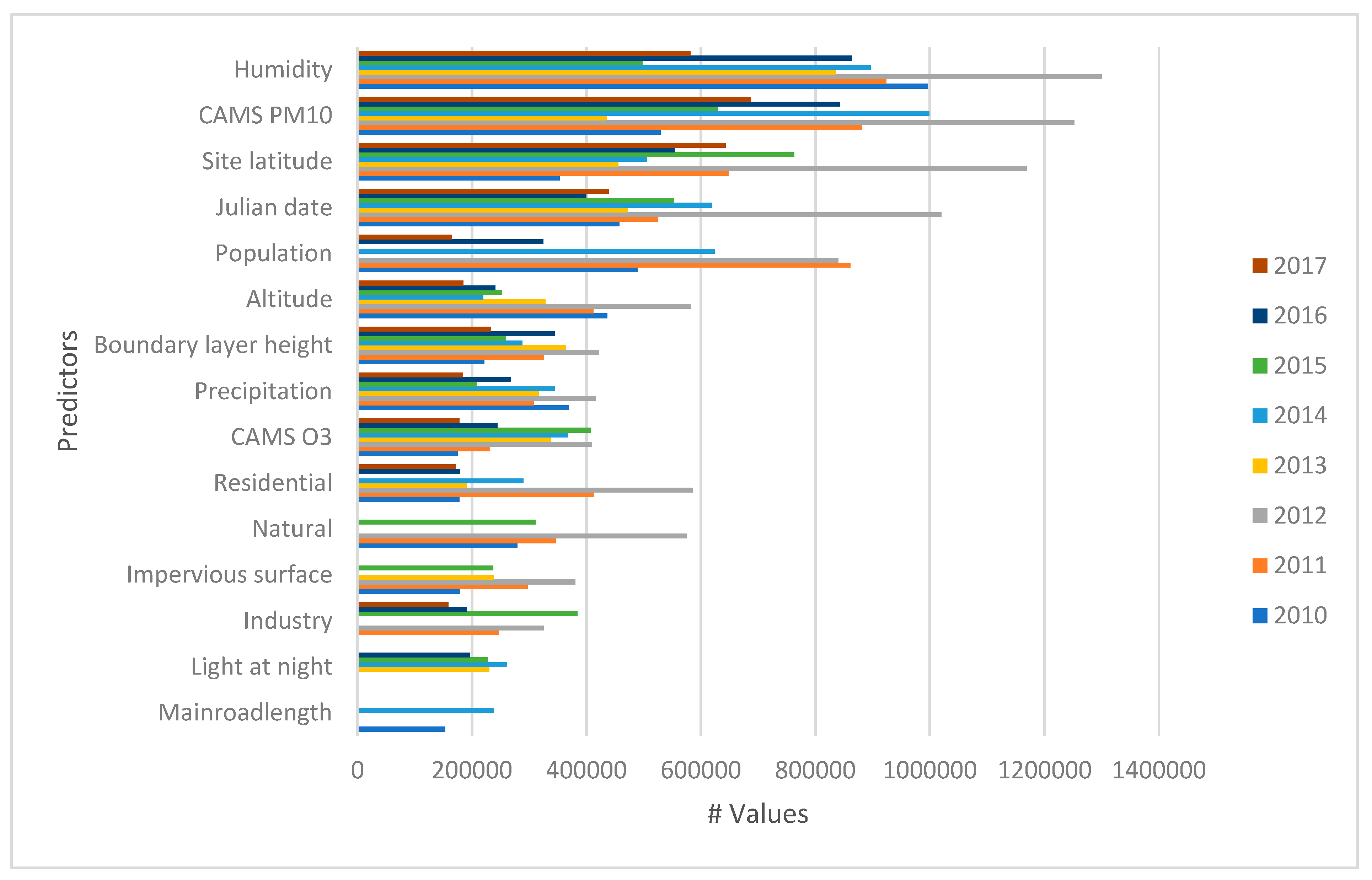
3. Results
3.1. National Model
3.2. Provincial Model
3.3. Site-Specific Models
3.4. Models Prediction
4. Discussion
5. Conclusions
Supplementary Materials
Author Contributions
Funding
Institutional Review Board Statement
Informed Consent Statement
Data Availability Statement
Acknowledgments
Conflicts of Interest
References
- Murray, C.J.; Aravkin, A.Y.; Zheng, P.; Abbafati, C.; Abbas, K.M.; Abbasi-Kangevari, M.; Abd-Allah, F.; Abdelalim, A.; Abdollahi, M.; Abdollahpour, I.; et al. Global burden of 87 risk factors in 204 countries and territories, 1990–2019: A systematic analysis for the Global Burden of Disease Study 2019. Lancet 2020, 396, 1223–1249. [Google Scholar] [CrossRef]
- Amegah, A.K.; Agyei-Mensah, S. Urban air pollution in Sub-Saharan Africa: Time for action. Environ. Pollut. 2017, 220, 738–743. [Google Scholar] [CrossRef]
- Fayiga, A.O.; Ipinmoroti, M.O.; Chirenje, T. Environmental pollution in Africa. Environ. Dev. Sustain. 2018, 20, 41–73. [Google Scholar] [CrossRef]
- Pope, C.A., III. Epidemiological basis for particulate air pollution health standards. Aerosol Sci. Technol. 2000, 32, 4–14. [Google Scholar] [CrossRef]
- Pope, C.A., III; Dockery, D.W. Health effects of fine particulate air pollution: Lines that connect. J. Air Waste Manag. Assoc. 2006, 56, 709–742. [Google Scholar] [CrossRef] [PubMed]
- Khumalo, T.J. 2017 State of Air Report and National Air Quality Indicator; Department of Environmental Affairs: Pretoria, South Africa, 2017. [Google Scholar]
- Department of Environmental Affairs. 2nd South Africa Environment Outlook; Department of Environmental Affairs: Pretoria, South Africa, 2016. [Google Scholar]
- Scott, G.M. Development of a Methodology for the Delineation of Air Quality Management Areas in South Africa. Ph.D. Thesis, University of KwaZulu-Natal, Westville, South Africa, 2010. [Google Scholar]
- Garland, R.M.; Naidoo, M.; Sibiya, B.A.; Oosthuizen, R. Air quality indicators from the Environmental Performance Index: Potential use and limitations in South Africa. Clean Air J. 2017, 27, 33–41. [Google Scholar] [CrossRef]
- Feig, G.; Garland, R.M.; Naidoo, S.; Maluleke, A.; Van der Merwe, M. Assessment of changes in concentrations of selected criteria pollutants in the Vaal and Highveld priority areas. Clean Air J. 2019, 29. [Google Scholar] [CrossRef]
- Feig, G.T.; Naidoo, S.; Ncgukana, N. Assessment of ambient air pollution in the Waterberg Priority Area 2012–2015. Clean Air J. 2016, 26, 21–28. [Google Scholar] [CrossRef]
- Venter, A.D.; Vakkari, V.; Beukes, J.P.; Van Zyl, P.G.; Laakso, H.; Mabaso, D.; Tiitta, P.; Josipovic, M.; Kulmala, M.; Pienaar, J.J.; et al. An air quality assessment in the industrialised western Bushveld Igneous Complex, South Africa. S. Afr. J. Sci. 2012, 108, 1–10. [Google Scholar] [CrossRef]
- Olaniyan, T.; Jeebhay, M.; Röösli, M.; Naidoo, R.N.; Künzli, N.; de Hoogh, K.; Saucy, A.; Badpa, M.; Baatjies, R.; Parker, B.; et al. The association between ambient NO2 and PM2.5 with the respiratory health of school children residing in informal settlements: A prospective cohort study. Environ. Res. 2020, 186, 109606. [Google Scholar] [CrossRef]
- Junger, W.; De Leon, A.P. Imputation of missing data in time series for air pollutants. Atmos. Environ. 2015, 102, 96–104. [Google Scholar] [CrossRef]
- Gómez-Carracedo, M.P.; Andrade, J.M.; López-Mahía, P.; Muniategui, S.; Prada, D. A practical comparison of single and multiple imputation methods to handle complex missing data in air quality datasets. Chemometr. Intell. Lab. Syst. 2014, 134, 23–33. [Google Scholar] [CrossRef]
- De Hoogh, K.; Héritier, H.; Stafoggia, M.; Künzli, N.; Kloog, I. Modelling daily PM2.5 concentrations at high spatio-temporal resolution across Switzerland. Environ. Pollut. 2018, 233, 1147–1154. [Google Scholar] [CrossRef] [PubMed]
- Mandal, S.; Madhipatla, K.K.; Guttikunda, S.; Kloog, I.; Prabhakaran, D.; Schwartz, J.D.; Geo Health Hub India Team. Ensemble averaging based assessment of spatiotemporal variations in ambient PM2.5 concentrations over Delhi, India, during 2010–2016. Atmos. Environ. 2020, 224, 117309. [Google Scholar] [CrossRef]
- The Law Library of Congress. Regulation of Air Pollution; Global Legal Research Center: Washington, DC, USA, 2018. [Google Scholar]
- Stafoggia, M.; Bellander, T.; Bucci, S.; Davoli, M.; De Hoogh, K.; De’Donato, F.; Gariazzo, C.; Lyapustin, A.; Michelozzi, P.; Renzi, M.; et al. Estimation of daily PM10 and PM2.5 concentrations in Italy, 2013–2015, using a spatiotemporal land-use random-forest model. Environ. Int. 2019, 124, 170–179. [Google Scholar] [CrossRef]
- Stafoggia, M.; Johansson, C.; Glantz, P.; Renzi, M.; Shtein, A.; Hoogh, K.D.; Kloog, I.; Davoli, M.; Michelozzi, P.; Bellander, T. A Random Forest Approach to Estimate Daily Particulate Matter, Nitrogen Dioxide, and Ozone at Fine Spatial Resolution in Sweden. Atmosphere 2020, 11, 239. [Google Scholar] [CrossRef]
- Goldberg, D.L.; Gupta, P.; Wang, K.; Jena, C.; Zhang, Y.; Lu, Z.; Streets, D.G. Using gap-filled MAIAC AOD and WRF-Chem to estimate daily PM2.5 concentrations at 1 km resolution in the Eastern United States. Atmos. Environ. 2019, 199, 443–452. [Google Scholar] [CrossRef]
- Wong, D.W.; Yuan, L.; Perlin, S.A. Comparison of spatial interpolation methods for the estimation of air quality data. J. Expo. Sci. Environ. Epidemiol. 2004, 14, 404–415. [Google Scholar] [CrossRef]
- Li, H.Z.; Gu, P.; Ye, Q.; Zimmerman, N.; Robinson, E.S.; Subramanian, R.; Apte, J.S.; Robinson, A.L.; Presto, A.A. Spatially dense air pollutant sampling: Implications of spatial variability on the representativeness of stationary air pollutant monitors. Atmos. Environ. X 2019, 2, 100012. [Google Scholar] [CrossRef]
- Breiman, L. Random Forests. Mach. Learn. 2001, 45, 5–32. [Google Scholar] [CrossRef]
- Kuhn, M.; Johnson, K. Applied Predictive Modeling; Springer: New York, NY, USA, 2013; Volume 26. [Google Scholar]
- Wright, M.N. Random Forests: The First-Choice Method for Every Data Analysis? Leibniz Institute for Prevention Research & Epidemiology: Bremen, Germany, 2019; [delivered 28 September 2019]. [Google Scholar]
- Freeman, E.A.; Moisen, G.G.; Coulston, J.W.; Wilson, B.T. Random forests and stochastic gradient boosting for predicting tree canopy cover: Comparing tuning processes and model performance. Can. J. For. Res. 2016, 46, 323–339. [Google Scholar] [CrossRef]
- Meyer, H.; Reudenbach, C.; Hengl, T.; Katurji, M.; Nauss, T. Improving performance of spatio-temporal machine learning models using forward feature selection and target-oriented validation. Environ. Model. Softw. 2018, 101, 1–9. [Google Scholar] [CrossRef]
- Kuhn, M. Building predictive models in R using the caret package. J. Stat. Softw. 2008, 28, 1–26. [Google Scholar] [CrossRef]
- Eeftens, M.; Beelen, R.; de Hoogh, K.; Bellander, T.; Cesaroni, G.; Cirach, M.; Declercq, C.; Dėdelė, A.; Dons, E.; de Nazelle, A.; et al. Development of land use regression models for PM2.5, PM2.5 absorbance, PM10 and PMcoarse in 20 European study areas; results of the ESCAPE project. Environ. Sci. Technol. 2012, 46, 11195–11205. [Google Scholar] [CrossRef] [PubMed]
- Wang, M.; Beelen, R.; Basagana, X.; Becker, T.; Cesaroni, G.; de Hoogh, K.; Dedele, A.; Declercq, C.; Dimakopoulou, K.; Eeftens, M.; et al. Evaluation of land use regression models for NO2 and particulate matter in 20 European study areas: The ESCAPE project. Environ. Sci. Technol. 2013, 47, 4357–4364. [Google Scholar] [CrossRef]


| Variable | Description | Source | Resolution |
|---|---|---|---|
| Population density | Mean population within 1 × 1 km2 grid cell | SEDAC | ~1 km |
| Landcover | South Africa National Land Cover 2018 densities (summary of meters within the grid cells by land cover categories of Natural, Built-up, Residential, Agricultural, Industrial) | South Africa Department of Environmental Affairs. | 20 m |
| Light at night | 1 × 1 km2 Intersected aggregate | VIIRS-DNB | 750 m |
| Impervious Surface | 1 × 1 km2 Intersected aggregate after removing no data, clouds, shadows data | NOAA | 30 m |
| Elevation | 1 × 1 km2 intersected aggregate of mean elevation | SRTM Digital Elevation Database | 90 m |
| Roads | Summary of road length distance to nearest road type: major roads and other roads | OpenStreetMap | Lines |
| Climate zones | Cold interior, Temperate interior, Hot interior, Temperate coastal, Sub-tropical coastal, Arid interior | South Africa Bureau of Standards 2005 | 6 Zones |
| Meteorological variables (daily modelled planetary boundary layer height, temperature, precipitation, wind speed, wind direction, relative humidity, vertical velocity | Daily global ECMWF re-analysis estimates | ERA5-reanalysis | 10 × 10 km |
| Modeled Tropospheric estimates of NO2, PM10, O3 | Daily Chemical transport model estimate | Chemical transport model Copernicus Atmosphere Monitoring Service (CAMS) | 10 × 10 km |
| Model Building | Spatial LOLO CV | Temporal LTO CV | Data Availability | ||||||||
|---|---|---|---|---|---|---|---|---|---|---|---|
| R2 (Range) | RMSE (Range) | MAE (Range) | R2 (Range) | RMSE (Range) | MAE (Range) | R2 (Range) | RMSE (Range) | MAE (Range) | No of Unique Sites | Years | |
| National | 0.77–0.79 | 12.1–16.76 | 8.69–11.38 | 0.11–0.35 | 17.72–29.47 | 13.62–23.65 | 0.77–0.79 | 12.31–16.43 | 8.85–11.39 | 20–44 | 2010–2017 |
| Provincial * | |||||||||||
| Mpumalanga | 0.73–0.81 | 14.03–19.35 | 9.63–12.13 | 0.39–0.69 | 22.06–36.21 | 13.5–29.59 | 0.73–0.78 | 13.55–19.21 | 9.85–12.01 | 5–17 * | 2010–2017 |
| Gauteng | 0.49–0.79 | 10.34–23.36 | 9.24–16.75 | 0.26–0.52 | 19.72–34.25 | 15.69–29.42 | 0.52–0.79 | 15.11–23.43 | 9.94–16.87 | 6–18 * | 2010–2017 |
| Western Cape | 0.29–0.71 | 6.74–8.73 | 5.11–6.72 | 0.35–0.54 | 7.38–11.22 | 5.76–8.86 | 0.44–0.66 | 6.66–23.29 | 5.18–17.92 | 1–11 * | 2010–2017 |
| KwaZulu-Natal | 0.55–0.79 | 7.36–9.53 | 5.29–8.11 | 0.29–0.57 | 8.54–19.95 | 6.95–16.82 | 0.47–0.78 | 7.37–10.71 | 5.46–8 | 3–6 * | 2010–2017 |
| Site-specific ** | |||||||||||
| Beliville | 0.42–0.47 | 5.81–9.16 | 4.51–7.26 | NA | NA | NA | 0.45–0.49 | 5.67–9.02 | 4.45–7.03 | NA | 2012, 2013, 2015–2017 |
| Bodibeng | 0.54–0.63 | 16.89–19.42 | 13.61–15.07 | NA | NA | NA | 0.57–0.67 | 16.36–18.91 | 13.32–14.87 | NA | 2012–2013 |
| Brackenham | 0.41–0.49 | 8.06–8.95 | 6.31–7.10 | NA | NA | NA | 0.46–0.49 | 7.81–8.95 | 6.25–7.15 | NA | 2011, 2015–2017 |
| Booysens | 0.45–0.67 | 22.13–22.82 | 17.99–20.77 | NA | NA | NA | 0.5–0.71 | 22.10–25.74 | 17.87–20.53 | NA | 2012,2014 |
| Camden | 0.38–0.62 | 10.64–23.27 | 8.69–17.85 | NA | NA | NA | 0.39–0.65 | 10.29–22.43 | 9.61–17.15 | NA | 2013, 2015, 2017 |
| CBD | 0.38–0.59 | 6.35–9.55 | 4.93–7.45 | NA | NA | NA | 0.41–0.64 | 6.28–9.23 | 4.98–7.21 | NA | 2011–2013, 2015–2017 |
| City Hall | 0.45 | 10.29 | 7.69 | NA | NA | NA | 0.48 | 9.78 | 7.43 | NA | 2010 |
| Elandsfontein | 0.39–0.52 | 11.72–12.49 | 9.38–9.68 | NA | NA | NA | 0.45–0.57 | 11.17–11.79 | 8.99–9.38 | NA | 2016–2017 |
| Ermelo | 0.48–0.76 | 9.20–18.96 | 7.69–15.31 | NA | NA | NA | 0.51–0.77 | 9.12–19.98 | 7.54–13.89 | NA | 2010–2016 |
| Etwatwa | 0.63 | 24.03 | 18.74 | NA | NA | NA | 0.69 | 23.78 | 18.56 | NA | 2012 |
| Ferndale | 0.68–0.74 | 3.63–5.42 | 2.84–3.92 | NA | NA | NA | 0.65–0.77 | 3.49–5.38 | 2.76–3.88 | NA | 2010–2012 |
| Foreshore | 0.32–0.49 | 5.29–9.76 | 4.1–7.22 | NA | NA | NA | 0.33–0.49 | 5.27–9.58 | 4.13–7.08 | NA | 2011–2013,2015–2017 |
| Gangles | 0.48–0.74 | 11.86–13.4 | 9.22–10.11 | NA | NA | NA | 0.51–0.75 | 11.23–11.88 | 8.96–9.71 | NA | 2010, 2011, 2013,2014 |
| Germiston | 0.42 | 19.65 | 14.96 | NA | NA | NA | 0.44 | 19.07 | 14.79 | NA | 2011 |
| George | 0.55–0.56 | 7.09–8.41 | 5.49–6.56 | NA | NA | NA | 0.58 | 6.95–8.12 | 5.39–6.34 | NA | 2010, 2013 |
| Goodwood | 0.46–0.57 | 6.77–8.78 | 5.26–8.24 | NA | NA | NA | 0.49–0.59 | 6.60–8.49 | 5.29–7.80 | NA | 2011–2012, 2014–2016 |
| Grootvlei | 0.41–0.44 | 10.76–11.32 | 8.70–8.87 | NA | NA | NA | 0.42–0.49 | 10.65–11.12 | 8.63–8.82 | NA | 2011, 2013 |
| Hendrina | 0.39–0.71 | 11.12–17.02 | 8.32–13.62 | NA | NA | NA | 0.43–0.74 | 11.18–16.56 | 8.36–12.96 | NA | 2010–2012,2015–2016 |
| Middleburg | 0.67–0.81 | 7.81–19.25 | 6.08–14.73 | NA | NA | NA | 0.70–0.82 | 7.49–18.63 | 5.92–14.25 | NA | 2010–2016 |
| Olievenhoutbosch | 0.57 | 34.23 | 27.01 | NA | NA | NA | 0.59 | 34.16 | 26.98 | NA | 2012 |
| Orange Farm | 0.45–0.69 | 10.78–19.81 | 8.57–15.56 | NA | NA | NA | 0.49–0.71 | 10.23–19.49 | 8.28–15.62 | NA | 2010,2017 |
| Rosslyn | 0.55–0.61 | 5.91–11.49 | 4.77–9.30 | NA | NA | NA | 0.52–0.67 | 5.86–11.05 | 4.47.8.93 | NA | 2012–2014 |
| Secunda | 0.63–0.77 | 7.73–25.21 | 5.86–19.96 | NA | NA | NA | 0.67–0.77 | 7.47–24.64 | 5.75–19.7 | NA | 2010–2013 |
| Witbank | 0.72–0.83 | 9.21–22.33 | 7.63–17.27 | NA | NA | NA | 0.73–0.83 | 8.79–21.87 | 7.34–16.75 | NA | 2010,2013–2016 |
| Komati | 0.45–0.83 | 8.52–28.02 | 6.61–21.51 | NA | NA | NA | 0.46–0.84 | 8.29–27.11 | 6.5–20.91 | NA | 2011–2012,2014–2017 |
| Leandra | 0.29–0.36 | 6.63–14 | 4.86–10.38 | NA | NA | NA | 0.35–0.4 | 6.35–13.64 | 4.81–10.31 | NA | 2011–2012 |
| Newtown | 0.43 | 22.07 | 17.52 | NA | NA | NA | 0.47 | 21.68 | 17.27 | NA | 2012 |
| Phola | 0.54–0.65 | 22.44–28.89 | 17.83–22.55 | NA | NA | NA | 0.57–0.65 | 22.02–28.88 | 17.48–22.72 | NA | 2013–2014,2016–2017 |
| Stellenbosch | 0.35–0.56 | 6.34–7.31 | 4.85–5.67 | NA | NA | NA | 0.37–0.61 | 6.26–7.14 | 4.83–5.62 | NA | 2012–2013 |
| Tableview | 0.36–0.4 | 5.63–7.04 | 4.43–5.81 | NA | NA | NA | 0.38–0.43 | 5.54–7 | 4.31–5.6 | NA | 2011–2013 |
| Tembisa | 0.71 | 17.78 | 14.09 | NA | NA | NA | 0.73 | 17.35 | 13.89 | NA | 2011 |
| Thokoza | 0.56 | 41.30 | 29.22 | NA | NA | NA | 0.57 | 40.25 | 28.76 | NA | 2011 |
| Wallacedene | 0.47–0.51 | 5.53–11.26 | 4.28–8.9 | NA | NA | NA | 0.47–0.54 | 5.52–10.82 | 4.29–8.69 | NA | 2012, 2015–2017 |
| Wattville | 0.52 | 39.10 | 29.09 | NA | NA | NA | 0.57 | 37.16 | 28.57 | NA | 2012 |
| Club | 0.59–0.67 | 11.01–14.87 | 8.76–11.86 | NA | NA | NA | 0.62–0.69 | 10.7–14.88 | 8.55–11.99 | NA | 2012–2014, 2016–2017 |
| Ekandustria | 0.46–0.59 | 11.14–16.83 | 8.88–13.09 | NA | NA | NA | 0.50–0.64 | 10.58–16.43 | 8.5–12.83 | NA | 2013–2014 |
| Embalenhle | 0.56–0.73 | 16.48–22.18 | 11.34–14.69 | NA | NA | NA | 0.59–0.73 | 13.31–22.18 | 11.03–17.86 | NA | 2012,2014,2016–2017 |
| Verkykkop | 0.44–0.49 | 6.63–9.71 | 5.53–7.88 | NA | NA | NA | 0.47–0.48 | 6.56–9.49 | 5.33–7.72 | NA | 2013,2016–2017 |
| Randwater | 0.32–0.73 | 12.99–15.99 | 9.82–15.83 | NA | NA | NA | 0.36–0.75 | 12.08–15.63 | 9.57–12.19 | NA | 2013–2017 |
| Esikhaweni | 0.43–0.58 | 9.07.9.45 | 7.36–7.4 | NA | NA | NA | 0.44–0.60 | 8.95–9.35 | 7.17 | NA | 2016–2017 |
| Chicken Farm | 0.44 | 13.14 | 10.44 | NA | NA | NA | 0.48 | 12.71 | 10.21 | NA | 2017 |
| Kwazamokuhle | 0.65 | 18.10 | 14.44 | NA | NA | NA | 0.67 | 17.10 | 13.84 | NA | 2017 |
| Kriel Village | 0.62 | 17.27 | 13.55 | NA | NA | NA | 0.66 | 16.89 | 13.41 | NA | 2017 |
| Bosjesspruit | 0.51 | 13.05 | 10.44 | NA | NA | NA | 0.55 | 12.58 | 10.27 | NA | 2017 |
| Province | Mean | SD | Percentiles | |||||
|---|---|---|---|---|---|---|---|---|
| µg/m3 | µg/m3 | 5 | 25 | 50 | 75 | 95 | ||
| Mpumalanga | Observed | 35.70–50.90 | 17.70–29.10 | 9.30–15.30 | 21.40–30.30 | 32.90–46.20 | 47.70–71.20 | 68.20–102.80 |
| National | 34.60–48.60 | 6.30–11.10 | 23.70–34.20 | 29.20–41.10 | 34.30–47.80 | 39.50–56.80 | 45.70–66.50 | |
| Provincial | 34.20–46.30 | 10.40–17.40 | 17.10–24.70 | 24.90–33.60 | 32.20–44.30 | 42.30–60.40 | 53.00–75.80 | |
| Site-specific | 35.70–52.00 | 11.40–19.50 | 18.60–26.10 | 26.80–37.10 | 34.30–49.80 | 43.30–66.90 | 55.50–85.40 | |
| Gauteng | Observed | 53.40–58.30 | 28.40–31.30 | 16.20–20.30 | 31.10–35.20 | 47.50–52.10 | 71.10–77.10 | 107.60–115.00 |
| National | 36.30–41.60 | 10.20–12.90 | 21.30–24.40 | 27.00–31.00 | 34.80–40.70 | 44.60–52.00 | 54.00–62.40 | |
| Provincial | 52.90–59.40 | 16.90–17.90 | 30.80–35.50 | 40.30–45.40 | 50.20–56.50 | 66.10–73.30 | 81.20–90.00 | |
| Site-specific | 53.00–58.40 | 17.40–19.70 | 29.30–33.50 | 37.90–43.10 | 49.70–54.80 | 65.60–72.30 | 84.70–93.20 | |
| Western Cape | Observed | 19.50–26.70 | 8.10–11.60 | 8.50–12.70 | 13.40–18.70 | 18.50–25.20 | 24.30–33.30 | 35.00–48.10 |
| National | 31.90–49.10 | 7.10–11.20 | 22.00–35.90 | 26.00–41.00 | 29.90–46.80 | 36.60–55.40 | 45.20–71.60 | |
| Provincial | 20.00–28.00 | 39.00–5.50 | 13.50–20.40 | 16.70–24.10 | 20.00–28.00 | 22.70–31.80 | 26.90–37.10 | |
| Site-specific | 19.50–26.70 | 4.80–6.60 | 11.80–17.90 | 15.90–21.80 | 18.80–26.20 | 22.40–30.70 | 28.00–38.40 | |
| KwaZulu-Natal | Observed | 24.20–29.80 | 11.01–14.01 | 9.50–13.50 | 15.90–20.01 | 22.10–26.60 | 30.70–37.10 | 45.70–56.60 |
| National | 31.60–43.80 | 8.20–12.90 | 21.10–28.40 | 24.50–33.40 | 29.00–40.40 | 37.60–53.00 | 47.60–66.00 | |
| Provincial | 23.90–32.90 | 5.20–9.50 | 15.60–21.60 | 19.20–25.90 | 22.50–31.60 | 27.10–39.40 | 35.40–49.50 | |
| Site-specific | 24.20–30.50 | 6.01–10.02 | 15.30–19.70 | 19.10–23.30 | 23.00–28.30 | 28.00–36.00 | 36.00–50.80 |
Publisher’s Note: MDPI stays neutral with regard to jurisdictional claims in published maps and institutional affiliations. |
© 2021 by the authors. Licensee MDPI, Basel, Switzerland. This article is an open access article distributed under the terms and conditions of the Creative Commons Attribution (CC BY) license (http://creativecommons.org/licenses/by/4.0/).
Share and Cite
Arowosegbe, O.O.; Röösli, M.; Künzli, N.; Saucy, A.; Adebayo-Ojo, T.C.; Jeebhay, M.F.; Dalvie, M.A.; de Hoogh, K. Comparing Methods to Impute Missing Daily Ground-Level PM10 Concentrations between 2010–2017 in South Africa. Int. J. Environ. Res. Public Health 2021, 18, 3374. https://doi.org/10.3390/ijerph18073374
Arowosegbe OO, Röösli M, Künzli N, Saucy A, Adebayo-Ojo TC, Jeebhay MF, Dalvie MA, de Hoogh K. Comparing Methods to Impute Missing Daily Ground-Level PM10 Concentrations between 2010–2017 in South Africa. International Journal of Environmental Research and Public Health. 2021; 18(7):3374. https://doi.org/10.3390/ijerph18073374
Chicago/Turabian StyleArowosegbe, Oluwaseyi Olalekan, Martin Röösli, Nino Künzli, Apolline Saucy, Temitope Christina Adebayo-Ojo, Mohamed F. Jeebhay, Mohammed Aqiel Dalvie, and Kees de Hoogh. 2021. "Comparing Methods to Impute Missing Daily Ground-Level PM10 Concentrations between 2010–2017 in South Africa" International Journal of Environmental Research and Public Health 18, no. 7: 3374. https://doi.org/10.3390/ijerph18073374
APA StyleArowosegbe, O. O., Röösli, M., Künzli, N., Saucy, A., Adebayo-Ojo, T. C., Jeebhay, M. F., Dalvie, M. A., & de Hoogh, K. (2021). Comparing Methods to Impute Missing Daily Ground-Level PM10 Concentrations between 2010–2017 in South Africa. International Journal of Environmental Research and Public Health, 18(7), 3374. https://doi.org/10.3390/ijerph18073374