
A Conceptual Design of Smart Management System for Flooding Disaster


Abstract
1. Introduction
2. Background and Related Work
3. Literature Review
3.1. Before Disaster
3.2. During Disaster
3.3. After Disaster
4. Methodology
- Defining the system requirements.
- Using a use case diagram approach to visualize the role of participants.
- Using a class diagram approach to visualize the system activities.
- Before Flood Disaster Stage
- System requirements
- PCs, sensors, networks, data centers, database (DB), and Internet service.
- Smart devices containing Global Positioning System (GPS) software.
- The alarming system connected to AI software.
- The training center containing all training requirements to train citizens and disaster teams.
- Food, medicines, and equipment to be used during and after the disaster.
- People
- Disaster Management Team
- Team leader: this person is responsible for declaring a state of emergency in the event of a disaster and has the authority to issue instructions to the disaster management and support teams as well as volunteers. This person is also responsible for the management of disaster from the moment of its occurrence until the last stage. Therefore, this person must have administrative authority, such as being a governor or the city mayor.
- Team members: as members of the disaster management team, they are experienced in dealing with all types of disasters and have sufficient skills to train volunteers and control any emergency during a disaster. Members of the team must always be in a state of readiness for disasters.
- Supporting
- •
- Police officers: police officers have an important role in the event of disasters, as they have experience in first aid and various other ways to deal with emergencies. In addition, they can protect important facilities from tampering and theft.
- •
- Firefighters: the main role of firefighters is to put out the fires caused by the disaster; they are also essential in rescuing people trapped in the rubble because of the collapse of buildings. They also have experience in first aid.
- •
- Paramedics: the primary duty of paramedics is to provide first aid to injured people and transfer serious cases to the hospital in the event of disasters.
- •
- Transporters: transporters evacuate people affected by the disaster to safe areas in order to preserve their lives. In addition, they must also be able to provide first aid during the disaster.
- •
- Volunteers: volunteers are civilians who have been trained by the disaster management teams on first aid, therefore, they are useful during disasters to save people and minimize casualties.
- c.
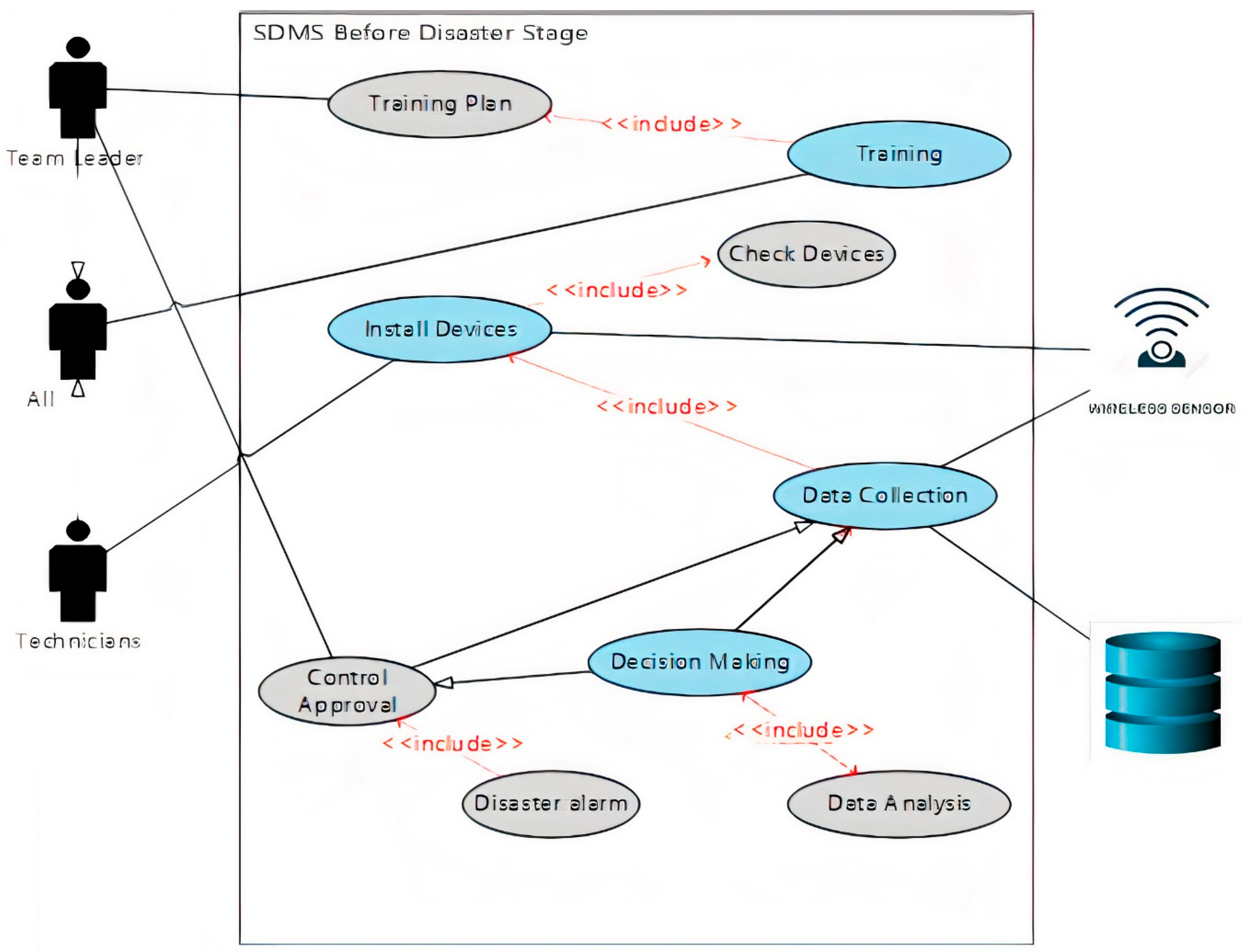
- Use Case Diagram
- 1.
- The team leader is responsible for determining the training plan, its dates, the participants, and the necessary materials.
- 2.
- All SDMS team, including the team leader, will participate in the training program in order to be ready to deal with the disaster.
- 3.
- Technicians are responsible for installing the system hardware, connecting, and testing the network and conducting periodic checks on all parts to ensure it is working properly.
- 4.
- Sensors start sending their data to the data center to check the monitored area for any abnormal situation.
- 5.
- The data center will receive data and analyze it; if any abnormal pattern is detected, the system will compare the abnormal data with the historical data stored in the DB.
- 6.
- If the system decides that there is danger, an alarm message will be sent to the team leader.
- 7.
- The team leader will determine the risk ratio according to the data received from the data center.
- 8.
- If the situation is controllable, the team leader will send the specialists to control the situation and send their report to the DB to be saved as historical data.
- 9.
- If the level of risk is high, the team leader will declare an emergency and start the second phase of the system.
- d.
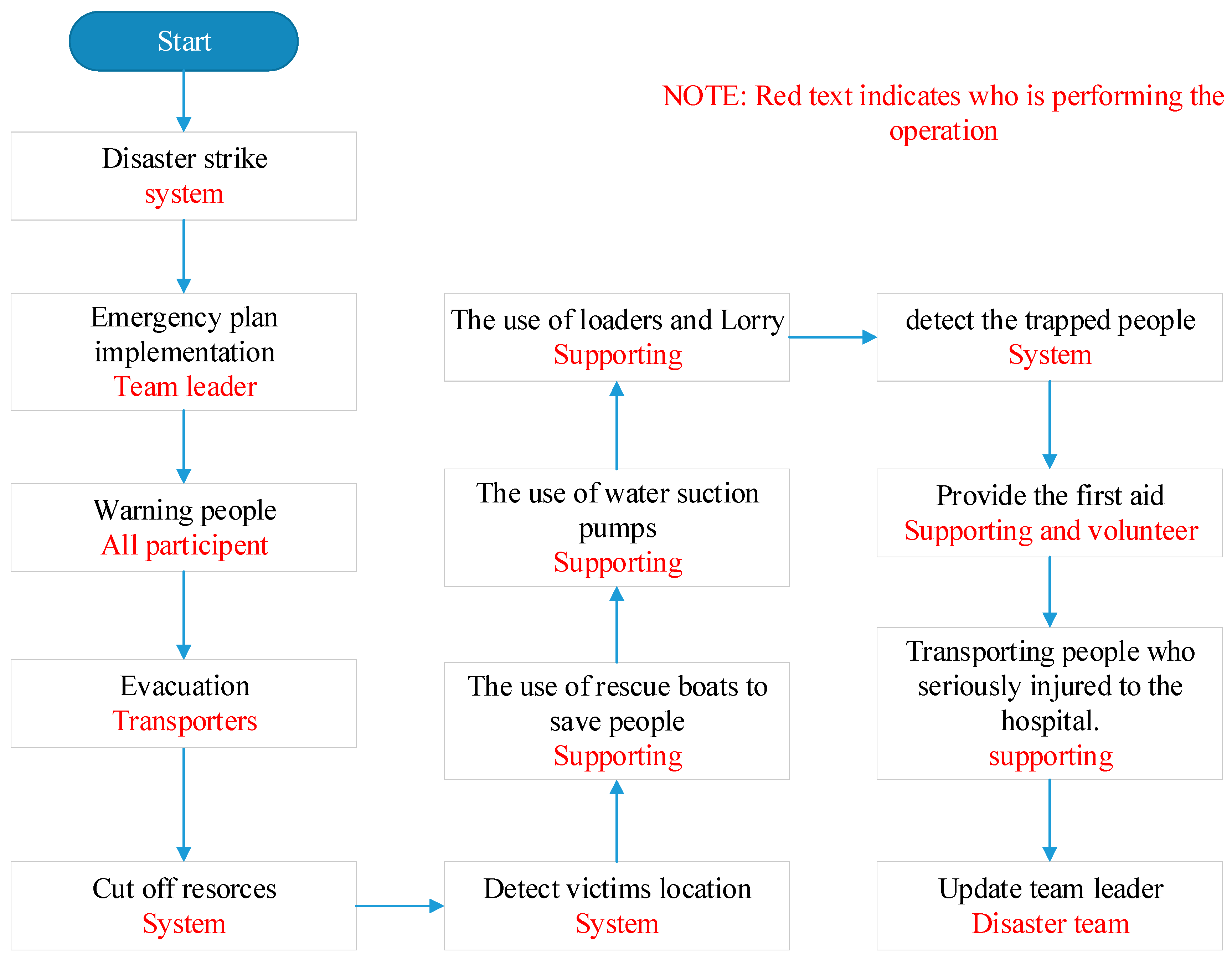
- Flooding scenario
- The team leader sends an alarm message to the team members, supporting teams, and civilian volunteers, ordering them to start the flooding disaster plan.
- The first step in the flooding disaster plan is warning people of flood disaster by using all communication methods such as SMSs, social media, TV channels, and radios and encouraging them to go to the safe zone.
- Use radio-frequency identification (RFID) technology to detect the location of the elderly and the disabled in order to save them.
- Evacuate people and transport them to safe areas that have been prepared during the preparatory phase of the disaster.
- Cut off electricity, gas, and water sources to avoid any additional damage caused by them.
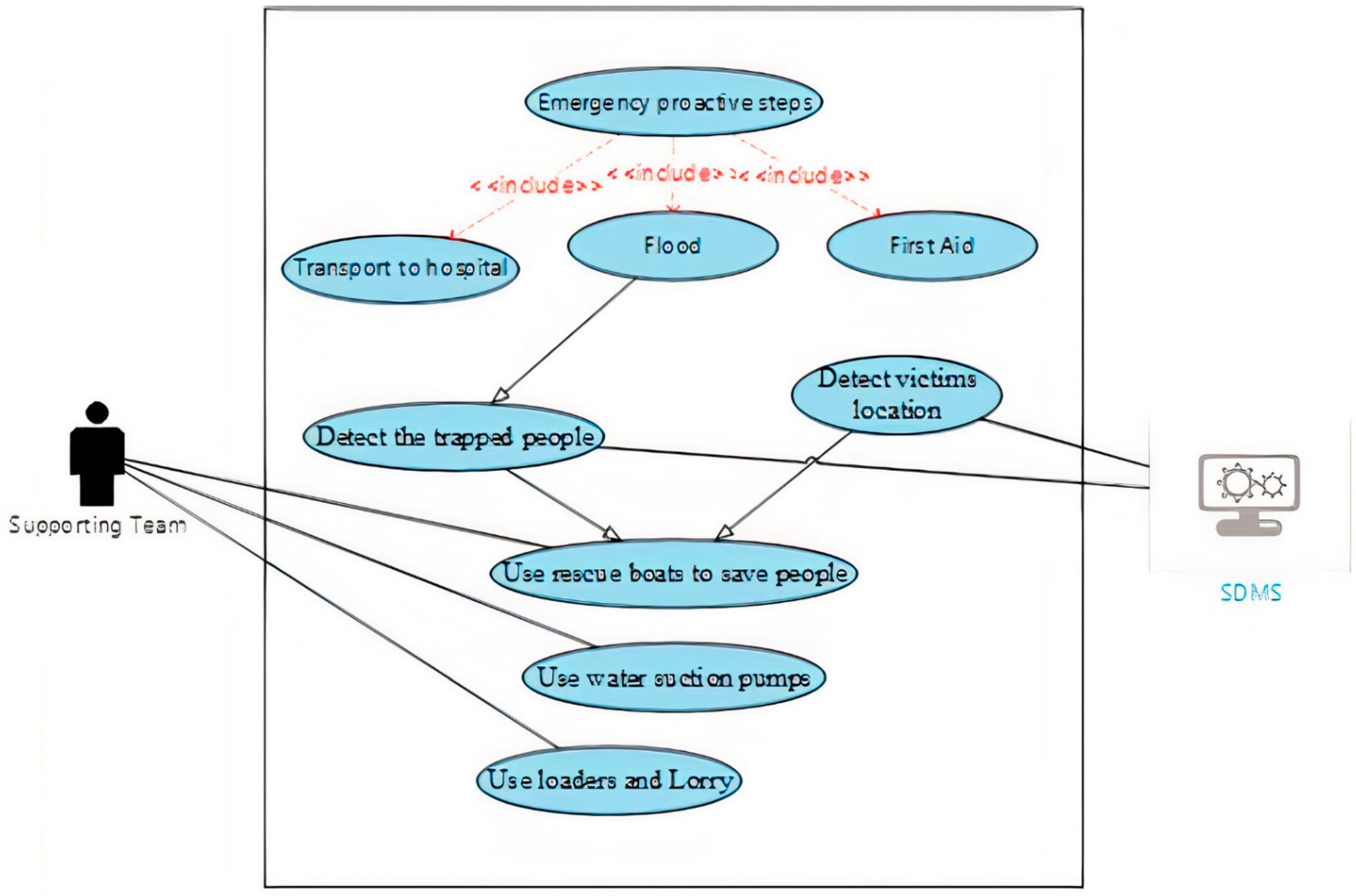
- Use rescue boats to save people at risk of drowning and recover bodies.
- Use water suction pumps to reduce the water pressure from the affected areas.
- Use loaders and lorries to make earth mounds that keep floodwaters in control.
- Use RFID to detect trapped people and save them.
- Provide first aid to people affected with minor injuries.
- Transport people who are seriously injured to the hospital.
- Keep the team leader informed about the latest updates of the disaster and the real situation on the ground.
- 2.
- During Flood Disaster Stage
- Requirements
- Cell phones, smart devices, PCs, satellite channels, and internet service.
- Buses, ambulances, fire vehicles, police cars, fire fighting aircraft, rescue boats, lifeboats, loaders, and lorries.
- Sensors, RFIDs, wireless communication devices.
- Electric generators, water suction pumps, masks, respirators, and fire extinguishers.
- People
- Disaster management team (team leader, team members)
- Supporting (police officers, firefighters, pilots (to drive firefighting aircraft), divers (to search for sunken people), paramedics, transporters, volunteers).
- Responsibilities
- d.
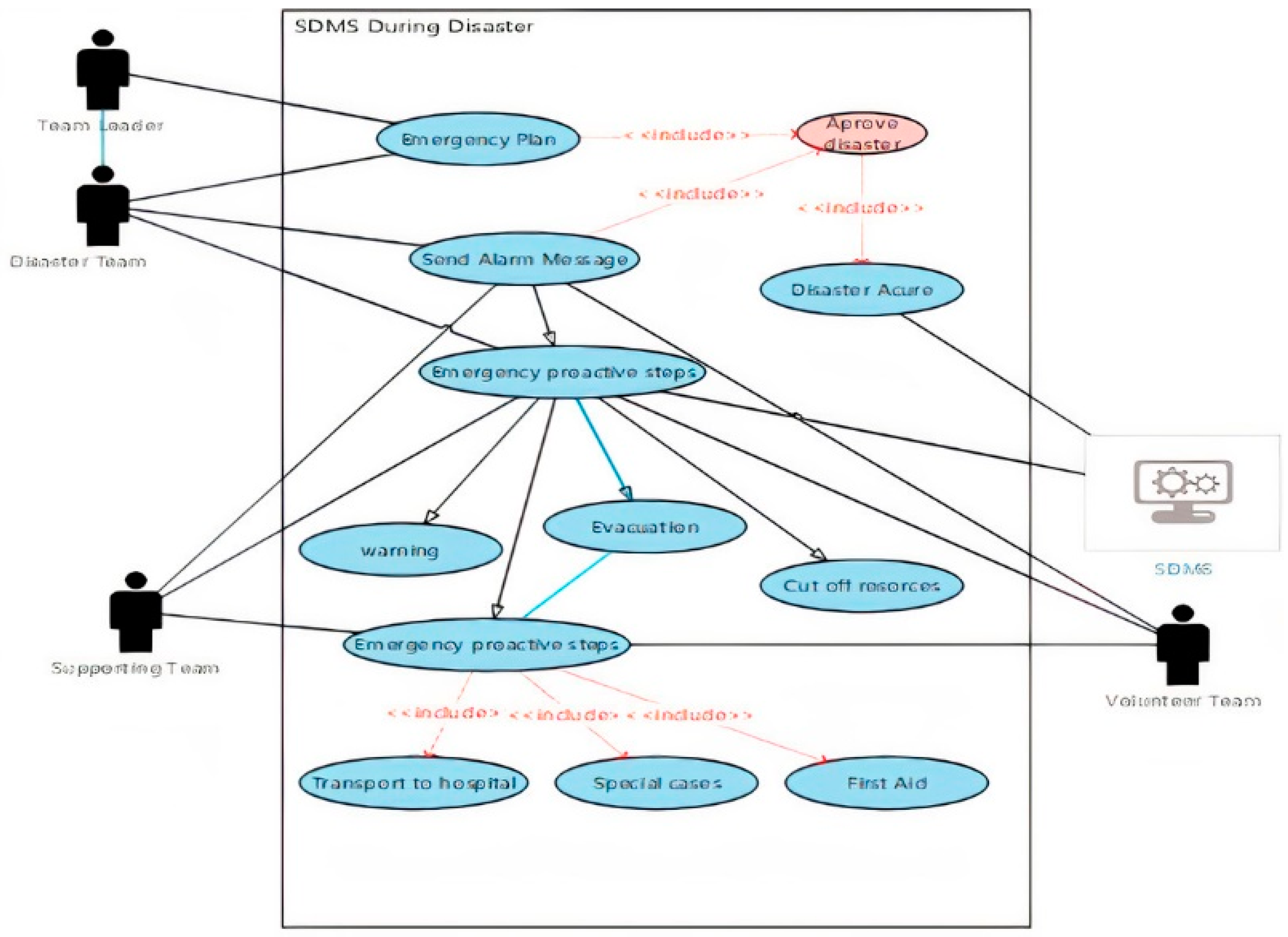
- Use case diagram of during the disaster stage
- The team leader is responsible for announcing the disaster and approving the use of the emergency plan.
- All SDMS teams will start warning people about the disaster.
- The transporters who are part of supporting team will evacuate people to the safe zone.
- The supporting team and the system will cut off the electricity, gas, and water to prevent additional damage.
- The supporting team will deal with the special cases which will be explained in detail later.
- The volunteer team will provide the first aid to injured people who are not in critical conditions.
- Ambulances from the supporting team will transfer the critical cases to the hospital.
- 3.
- After Disaster Stage
- Requirements
- Cell phones, smart devices, PCs, DB, Internet service, RFID, and statistics software.
- Tents, food, clean water, and medicine.
- Trucks, ambulances, police cars, generators, water treatment plants.
- Building materials.
- People
- Disaster management team (team leader, team members)
- Supporting (police officers, paramedics, statistics experts, technicians, construction workers, transporters)
- Volunteers
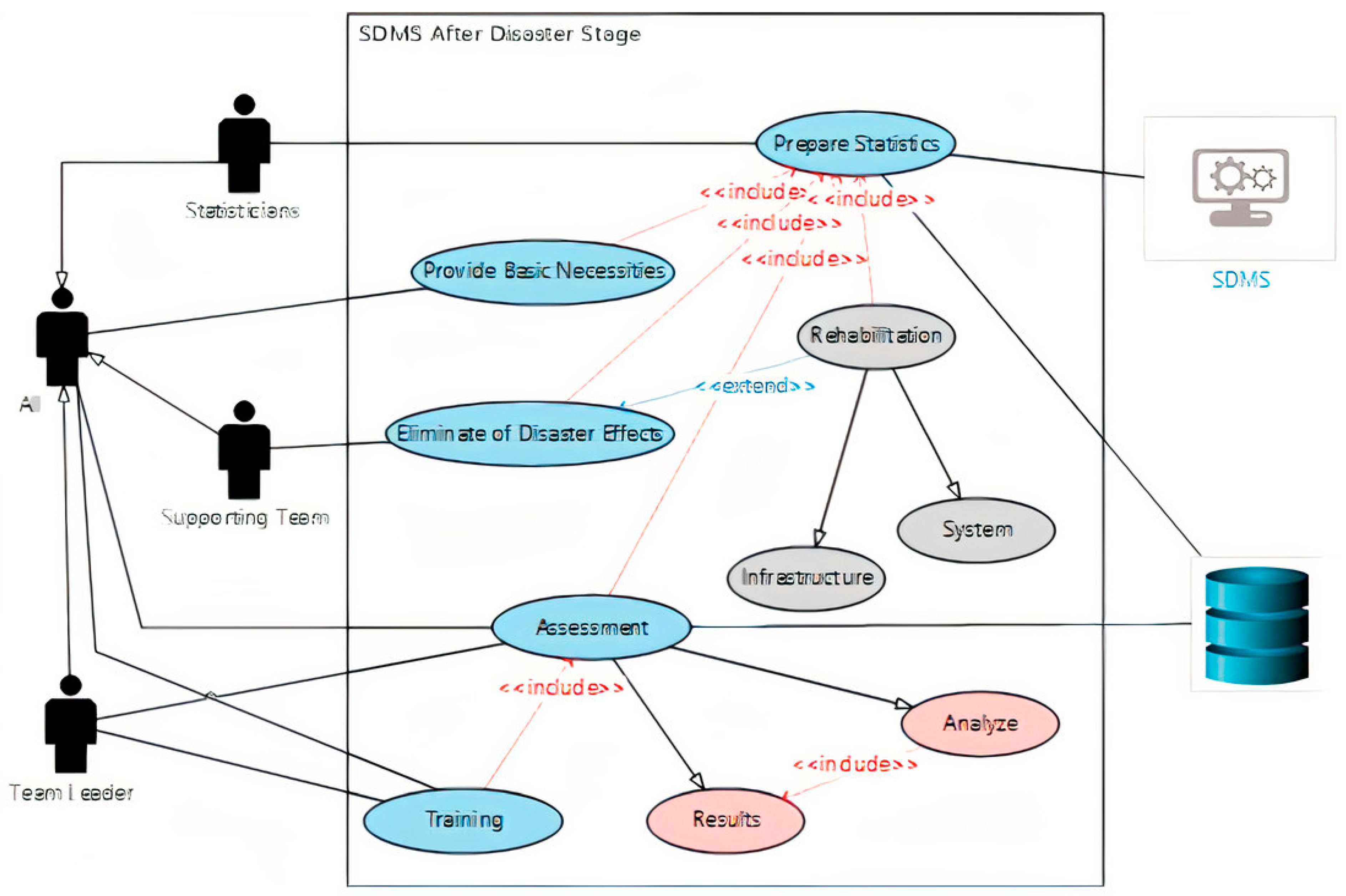
- Use case diagram of after disaster stage
- 1.
- Statisticians as a support team with the help of SDMS will conduct statistical analyses to determine the number of surviving, injured, missing, and dead people, in addition to identifying material losses and damage to infrastructure.
- 2.
- Based on the statistical report, the support team and volunteers will provide the survivors with the necessary food, drink, and medicine, as well as suitable places for living.
- 3.
- Construction workers as a support team with the help of volunteers will remove the debris caused by the disaster.
- 4.
- As a support team, construction workers will rehabilitate infrastructure and housing in the disaster-affected area.
- 5.
- Technicians as a support team will rehabilitate the SDMS and its associated equipment with a thorough inspection of all parts of the system to make sure they are working properly.
- 6.
- After the completion of the rehabilitation process, the team leader assesses the performance of the risk management team, supporters, and volunteers. He will analyze the speed of response and the way to better deal with the disaster. A copy of this report will be sent to the database to be saved as historical data training for the future.
- 7.
- The team leader announces the end of the disaster and orders the team to return to standby mode.
5. Discussion
6. Conclusions
Author Contributions
Funding
Institutional Review Board Statement
Informed Consent Statement
Conflicts of Interest
References
- Pascaline, W.; Rowena, H. Economic Losses, Poverty & Disaster 1998–2017. United Nations Office for Disaster Risk Reduction and Center for Research on the Epidemiology of Disasters. Available online: https://www.preventionweb.net/files/61119_credeconomiclosses.pdf (accessed on 15 February 2021).
- EM-DAT. General Classification. Available online: https://www.emdat.be/classification (accessed on 15 February 2021).
- Haraguchi, M.; Lall, U. Flood risks and impacts: A case study of Thailand’s floods in 2011 and research questions for supply chain decision making. Int. J. Disaster Risk Reduct. 2015, 14, 256–272. [Google Scholar] [CrossRef]
- Ritchie, H.; Roser, M. Natural Disaster. Available online: https://ourworldindata.org/natural-disasters (accessed on 5 February 2021).
- Norio, O.; Ye, T.; Kajitani, Y.; Shi, P.; Tatano, H. The 2011 eastern Japan great earthquake disaster: Overview and comments. Int. J. Disaster Risk Sci. 2012, 2, 34–42. [Google Scholar] [CrossRef]
- Sakhardande, P.; Hanagal, S.; Kulkarni, S. Design of disaster management system using IoT based interconnected network with smart city monitoring. In Proceedings of the International Conference on Internet of Things and Applications (IOTA), Pune, India, 22–24 January 2016; pp. 185–190. [Google Scholar]
- Segal, K.; Jong, J.; Halberstadt, J. The fusing power of natural disasters: An experimental study. Self Identity 2018, 17, 574–586. [Google Scholar] [CrossRef]
- Anthopoulos, L.G.; Reddick, C.G. Understanding Electronic Government Research and Smart City: A Framework and Empirical Evidence. Inf. Polity 2016, 21, 99–117. [Google Scholar] [CrossRef]
- Alazawi, Z.; Altowaijri, S.; Mehmood, R.; Abdljabar, M.B. Intelligent disaster management system based on cloud-enabled vehicular networks. In Proceedings of the 11th International Conference on ITS Telecommunications (ITST), St. Petersburg, Russia, 23–25 August 2011; pp. 361–368. [Google Scholar]
- Alazawi, Z.; Alani, O.; Abdljabar, M.B.; Altowaijri, S.; Mehmood, R. A smart disaster management system for future cities. In Proceedings of the 2014 ACM International Workshop on Wireless and Mobile Technologies for Smart Cities, Philadelphia, PA, USA, 11 August 2014; pp. 1–10. [Google Scholar]
- Fretas, D.; Battat, W. The Impact of Flood Risk on Urban Areas; Master Study; Urban Technology Management Institute, Mohamed Boudiaf University: Messila, Algeria, 2019; Available online: http://dspace.univ-msila.dz:8080//xmlui/handle/123456789/16324 (accessed on 17 February 2021).
- International Federation of Red Cross and Red Crescent Societies (IFRCRCS). World Disaster Report; International Federation of Red Cross and Red Crescent Societies: Geneva, Switzerland, 2018. [Google Scholar]
- Chan, N.W. Impacts of disasters and disasters risk management in Malaysia: The case of floods. In Economic and Welfare Impacts of Disasters in East Asia and Policy Responses; ERIA Research Project Report 2011-8; ERIA: Jakarta, Indonesia, 2012; pp. 503–551. [Google Scholar]
- Ghapar, A.; Yussof, S.; Bakar, A.A. Internet of Things (IoT) Architecture for Flood Data Management. Int. J. Future Gener. Commun. Netw. 2018, 11, 55–62. [Google Scholar] [CrossRef]
- Ward, P.J.; Pauw, W.P.; Van Buuren, M.W.; Marfai, M.A. Governance of flood risk management in a time of climate change: The cases of Jakarta and Rotterdam. Environ. Politics 2013, 22, 518–536. [Google Scholar] [CrossRef]
- Munich, R. Topics Annual Review: Natural Disasters 2014. Mnchener Rckversicherungs-Gesellschaf. Available online: http://www.munichre.com (accessed on 17 February 2020).
- Leskens, J.; Brugnach, M.; Hoekstra, A.; Schuurmans, W. Why are decisions in flood disaster management so poorly supported by information from flood models? Environ. Model. Softw. 2014, 53, 53–61. [Google Scholar] [CrossRef]
- Middelmann-Fernandes, M.H. Review of the Australian Flood Studies Database. Available online: http://www.ga.gov.au/image_cache/GA15570.pdf (accessed on 17 February 2020).
- Wang, F.; Yuan, H. Challenges of the sensor web for disaster management. Int. J. Digit. Earth 2010, 3, 260–279. [Google Scholar] [CrossRef]
- Bunker, D.; Levine, L.; Woody, C. Repertoires of collaboration for common operating pictures of disasters and extreme events. Inf. Syst. Front. 2015, 17, 51–65. [Google Scholar] [CrossRef]
- Marufish Disaster Preparedness, Marufish World of Disaster Preparedness. Available online: Marufish.com/disaster/flood/ (accessed on 14 January 2020).
- Fernando, M.; Gaol, F.L. Designing flood early warning system using internet of things. AIP Conf. Proc. 2018, 2043, 020020. [Google Scholar]
- Bindal, A.; Kadhim, M.H.; Parsad, D.; Patel, R.B. A Pragmatic Review on Algorithmic Approaches for Disaster Management using Wireless Sensor Networks. Int. J. Comput. 2014, 4, 2249054XV4I3052014-03. [Google Scholar]
- Rismayana, A.H.; Sugianto, C.A.; Budiyanto, I.B. Prototyping of Flooding Early Warning System using Internet of Things Technology and Social Media. In Proceedings of the 3rd Annual Applied Science and Engineering Conference (AASEC 2018), Bandung, Indonesia, 18 April 2018; EDP Sciences: Youlis, France, 2018; Volume 197, p. 16003. [Google Scholar]
- Ji, Z.; Anwen, Q. The application of internet of things (IOT) in emergency management system in China. In Proceedings of the 2010 IEEE International Conference on Technologies for Homeland Security (HST), Waltham, MA, USA, 8–10 November 2010; pp. 139–142. [Google Scholar]
- Chen, T.Y.; Wei, H.W.; Hsu, N.I.; Shih, W.K. A IoT application of safe building in IPv6 network environment. In Proceedings of the 2013 IEEE 37th Annual Computer Software and Applications Conference, Kyoto, Japan, 22–26 July 2013; pp. 748–753. [Google Scholar]
- Mitra, P.; Ray, R.; Chatterjee, R.; Basu, R.; Saha, P.; Raha, S.; Saha, S. Flood forecasting using Internet of things and artificial neural networks. In Proceedings of the 2016 IEEE 7th Annual Information Technology, Electronics and Mobile Communication Conference (IEMCON), Vancouver, BC, Canada, 13–15 October 2016; pp. 1–5. [Google Scholar]
- Perumal, T.; Sulaiman, M.N.; Leong, C.Y. Internet of Things (IoT) enabled water monitoring system. In Proceedings of the 2015 IEEE 4th Global Conference on Consumer Electronics (GCCE), Osaka, Japan, 27–30 October 2015; pp. 86–87. [Google Scholar]
- Mane, S.S.; Mokashi, M.K. Real-time flash-flood monitoring, alerting and forecasting system using data mining and wireless sensor network. In Proceedings of the 2015 International Conference on Communications and Signal Processing (ICCSP), Melmaruvathur, India, 2–4 April 2015; pp. 1881–1886. [Google Scholar]
- Du, C.; Zhu, S. Research on urban public safety emergency management early warning system based on technologies for the internet of things. Procedia Eng. 2012, 45, 748–754. [Google Scholar] [CrossRef]
- Kumar, S.A.; Bao, S.; Singh, V.; Hallstrom, J. Flooding disaster resilience information framework for smart and connected communities. J. Reliab. Intell. Environ. 2019, 5, 3–15. [Google Scholar] [CrossRef]
- Sarker, M.N.I.; Peng, Y.; Yiran, C.; Shouse, R.C. Disaster resilience through big data: Way to environmental sustainability. Int. J. Disaster Risk Reduct. 2010, 51, 101769. [Google Scholar] [CrossRef]
- Wellington, J.; Ramesh, P. Role of internet of things in disaster management. In Proceedings of the International Conference on Innovations in Information Embedded and Communication Systems (ICIIECS), Coimbatore, India, 17–18 March 2017. [Google Scholar]
- Rafi, M.M.; Aziz, T.; Lodi, S.H. A comparative study of disaster management information systems. Online Inf. Rev. 2018, 42, 6. [Google Scholar] [CrossRef]
- Shalini, E.; Surya, P.; Thirumurugan, R.; Subbulakshmi, S. Cooperative flood detection using SMS through IoT. Int. J. Adv. Res. Electr. Electron. Instrum. Eng. 2016, 5, 3410–3414. [Google Scholar]
- Organization of American States Disasters (OAS). Planning and Development: Managing Natural Hazards to Reduce Loss; Technical Report; Department of Regional Development and Environment: Washington, DC, USA, 1990.
- Yao, K. E-Government for Disaster Risk Management; UN Department of Economic and Social Affairs: New York, NY, USA, 2015.
- Eraslan, Z.A.; Emem, O.; Helvacı, C.; Batuk, F.; Gümüsay, U.; Demir, N.; Turk, T.; Bayram, B. System Design of Desaster Manegment Information System in Turkey as a Part of E-Government; Yildiz Technical University Department of Geodesy and Photogrammetry: Istanbul, Turkey, 2004. [Google Scholar]
- Ibrahim, T. Conceptual Design of E-governance in Disaster Management System. Ph.D. Thesis, Atilim University, Modeling and Design of Engineering Systems Department, Ankara, Turkey, 2020. [Google Scholar]
- Lixin, Y.; Lingling, G.; Dong, Z.; Junxue, Z.; Zhanwu, G. An Analysis on Disasters Management System in China; Springer Science & Business Media B.V.: Berlin, Germany, 2012. [Google Scholar]
- Fan, C.; Mostafavi, A. Establishing a framework for disaster management system-of-systems. In Proceedings of the Annual IEEE International Systems Conference (SysCon), Vancouver, BC, Canada, 23–26 April 2018; pp. 1–7. [Google Scholar]
- Bonnie, L.; Mindy, K.; Mary, C.; Marshall, G.; Anthony, C.; Golden, G.; Sheila, S. Children and Disaster: Age, Gender, and Parental Effects on PTSD Symptoms; American Academy of Child and Adolescent Psychaitry: Washington, DC, USA, 2005. [Google Scholar]
- United Nations Office for Disaster Risk Reduction. Disaster Risk Management. Available online: https://www.undrr.org/terminology/disaster-risk-management (accessed on 1 January 2021).
- Asian Disaster Preparedness Center. Primer Series on ICTD for Youth; UN-APCICT/ESCAP: Incheon, Korea, 2016. [Google Scholar]
- Nowell, B.; Steelman, T.; Velez, A.-L.K.; Yang, Z. The structure of effective governance of disaster response networks: Insights from the field. Am. Rev. Public Adm. 2018, 48, 699–715. [Google Scholar] [CrossRef]
- Alfahdawi, K.; Ismaeel, H. Information Technology in Iraq Reality and Challenges; Technology University Scientific Journal: Baghdad, Iraq, 2014. [Google Scholar]
- Cockburn, A. Writing Effective Use Cases: The Agile Software Development Series; Pearson Education Inc.: London, England, 2008; pp. 13–196. [Google Scholar]
- Othman, S.H.; Beydoun, G. A metamodel-based knowledge sharing system for disaster management. Expert Syst. Appl. 2016, 63, 49–65. [Google Scholar] [CrossRef][Green Version]
- OMG. MDA Guide; USA; Version 1.0.1.; Object Management Group: Needham, MA, USA, 2003. [Google Scholar]
- Cook, S. Domain-specific modeling and model driven architecture. MDA J. BPT Column 2004, 9, 2–10. [Google Scholar]
- Ibrahim, T.; Mishra, A. Internet of Things (IoT) and Artificial Neural Networks Towards Water Pollution Forecasting. Rocz. Ochr. Sr. 2020, 2, 117–129. [Google Scholar]
- Goniewicz, K.; Burkle, F.M. Analysis of the Potential of IT System Support in Early Warning Systems: Mitigating Flood Risk in Poland. Prehosp. Disaster Med. 2019, 34, 563–565. [Google Scholar] [CrossRef] [PubMed]
- Goniewicz, K.; Magiera, M.; Burkle, F.M.; Goniewicz, M. Prospective Study on the Potential Use of Satellite Data for Disaster Prevention, Preparedness, and Mitigation in Poland; © World Association for Disaster and Emergency Medicine: Madison, WI, USA, 2020. [Google Scholar] [CrossRef]


| Wellington J, et al. (2017) [33] | Observed a lack of focus on the technical aspects of IoT technology. Argued that sensor networks, IoT, and embedded system structures can be used for the smart networks for emergency handling. |
| Rafi et al. (2018) [34] | Concluded an effective response to a disaster requires fast flow of information and integrated response activities; thus, computing technology can be helpful in this regard. |
| Shalini, et al. (2016) [35] | Designed a system to measure the level of water in the river using special sensors to measure water levels as the distance from the bottom of the river and send the data to the monitoring center using Wi-Fi technology, the information sent via smartphones using GSM technology to the decision-makers. |
| Organization of American States Disasters (OAS) (1990) [36] | Defined the (DMS) to harness the full potential of governmental and non-governmental institutions in the event of a disaster in order to minimize the damage caused by the latter. |
| K. Yao (2015) [37] | Provided another definition to the DMS, which is the system that is used to manage disaster-related data by using information technology (IT), which combines geographical information with administration information to facilitate access to and use of these data in all disaster stages. |
| Eraslan et al. (2004) [38] | Tried to change the administrative structure of the DMS by proposing the use of the communications side of (IoT) to connect all parts of the system with each other and make them work as one integrated unit. Then, they suggested the establishment of a central control unit that communicate with all other units of DMS using IoT. |
Publisher’s Note: MDPI stays neutral with regard to jurisdictional claims in published maps and institutional affiliations. |
© 2021 by the authors. Licensee MDPI, Basel, Switzerland. This article is an open access article distributed under the terms and conditions of the Creative Commons Attribution (CC BY) license (https://creativecommons.org/licenses/by/4.0/).
Share and Cite
Ibrahim, T.; Mishra, A. A Conceptual Design of Smart Management System for Flooding Disaster. Int. J. Environ. Res. Public Health 2021, 18, 8632. https://doi.org/10.3390/ijerph18168632
Ibrahim T, Mishra A. A Conceptual Design of Smart Management System for Flooding Disaster. International Journal of Environmental Research and Public Health. 2021; 18(16):8632. https://doi.org/10.3390/ijerph18168632
Chicago/Turabian StyleIbrahim, Thaer, and Alok Mishra. 2021. "A Conceptual Design of Smart Management System for Flooding Disaster" International Journal of Environmental Research and Public Health 18, no. 16: 8632. https://doi.org/10.3390/ijerph18168632
APA StyleIbrahim, T., & Mishra, A. (2021). A Conceptual Design of Smart Management System for Flooding Disaster. International Journal of Environmental Research and Public Health, 18(16), 8632. https://doi.org/10.3390/ijerph18168632