Association between the New COVID-19 Cases and Air Pollution with Meteorological Elements in Nine Counties of New York State


Abstract
1. Introduction
2. Methods
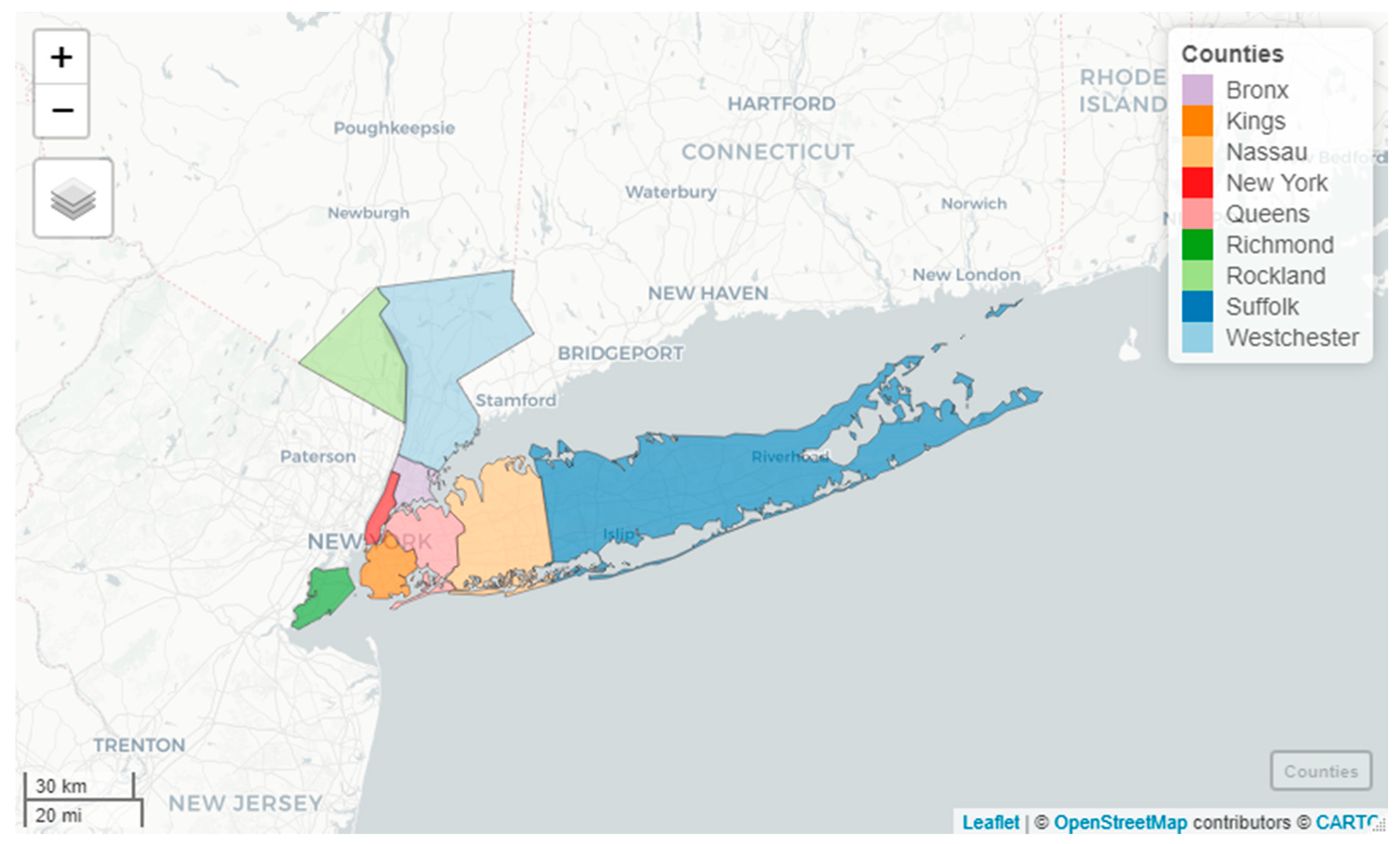
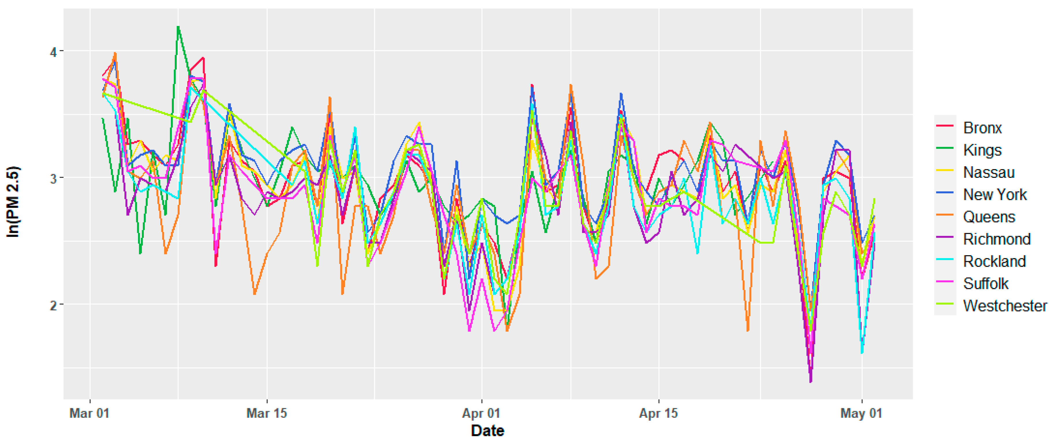
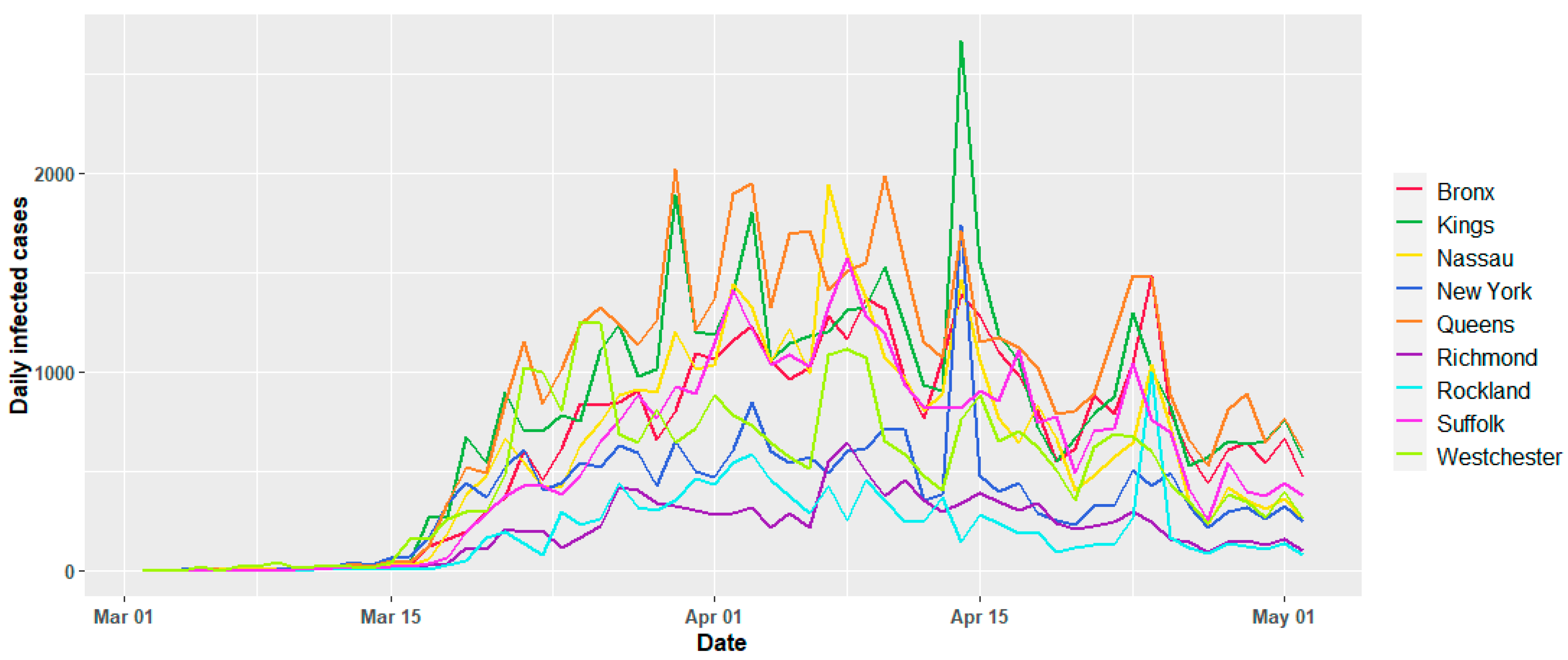
2.1. Data Settings
2.2. Statistical Methodology
Hierarchical Mixed Linear Model for COVID-19 Mortality
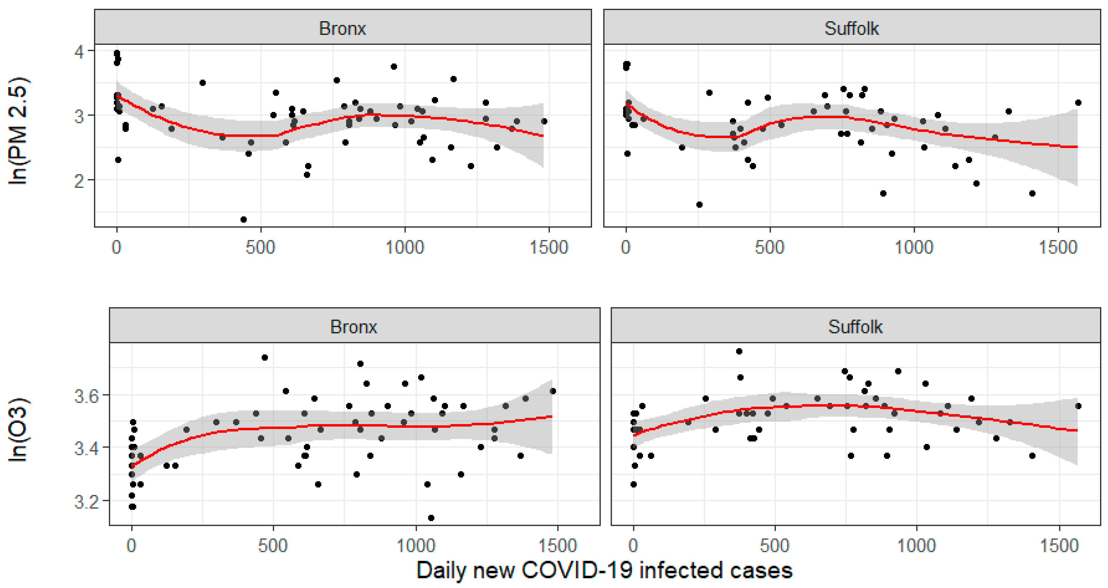
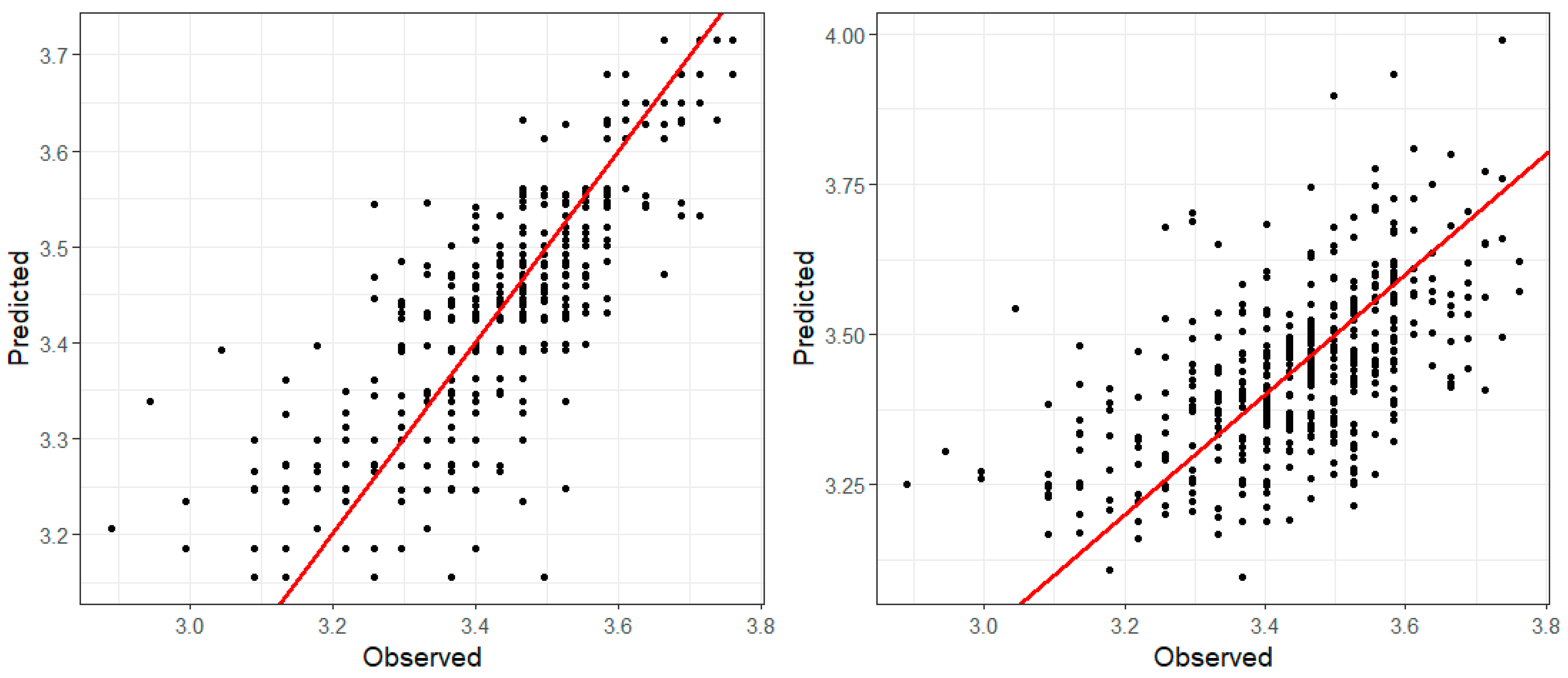
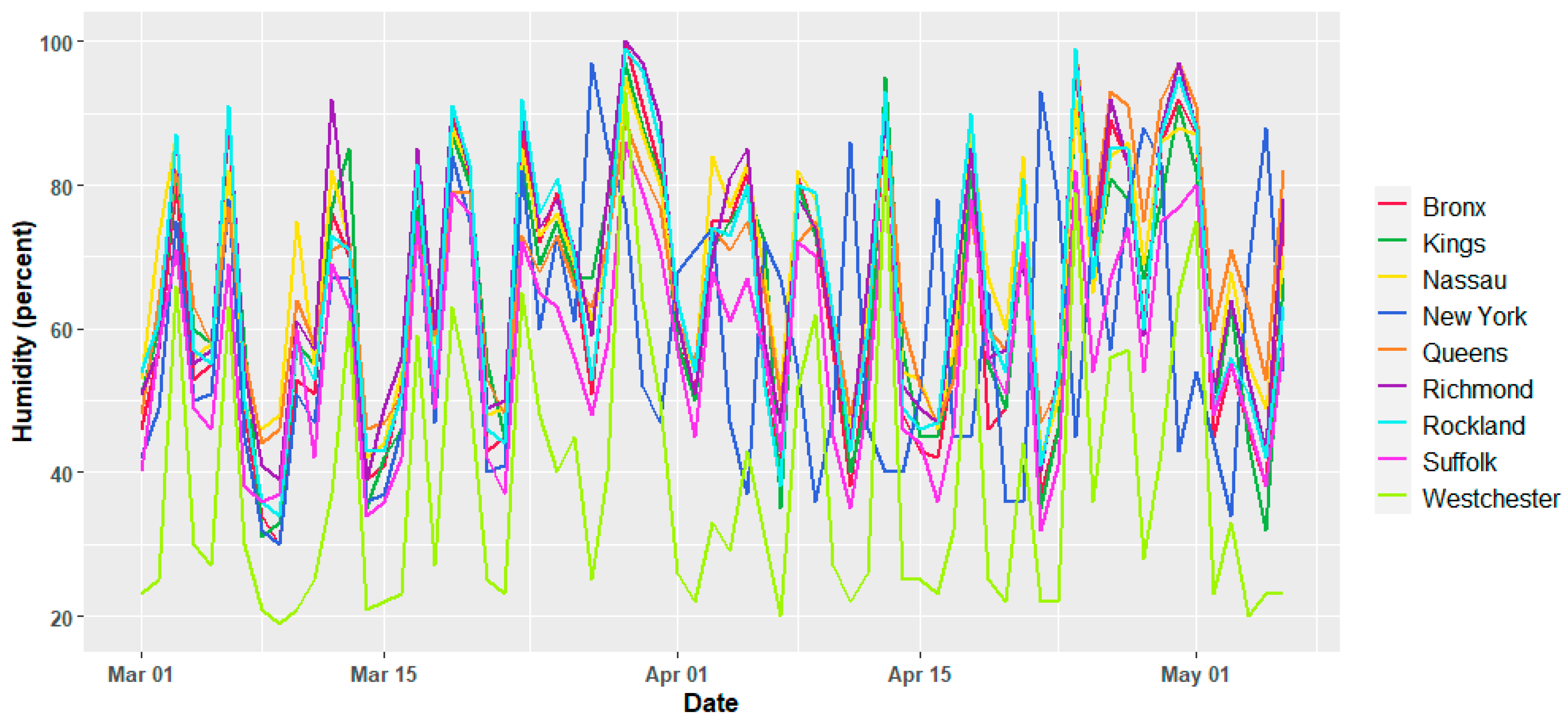
3. Results
4. Discussion
5. Conclusions
Author Contributions
Funding
Acknowledgments
Conflicts of Interest
Appendix A


References
- Li, L.; Li, Q.; Huang, L.; Wang, Q.; Zhu, A.; Xu, J.; Liu, Z.; Li, H.; Shi, L.; Li, R.; et al. Air quality changes during the COVID-19 lockdown over the Yangtze River Delta Region: An insight into the impact of human activity pattern changes on air pollution variation. Sci. Total Environ. 2020, 732, 139282. [Google Scholar] [CrossRef]
- Sharma, S.; Zhang, M.; Gao, J.; Zhang, H.; Kota, S.H. Effect of restricted emissions during COVID-19 on air quality in India. Sci. Total Environ. 2020, 728, 138878. [Google Scholar] [CrossRef]
- Zambrano-Monserrate, M.A.; Ruano, M.A.; Sanchez-Alcalde, L. Indirect effects of COVID-19 on the environment. Sci. Total Environ. 2020, 728, 138813. [Google Scholar] [CrossRef]
- Muhammad, S.; Long, X.; Salman, M. COVID-19 pandemic and environmental pollution: A blessing in disguise? Sci. Total Environ. 2020, 728, 138820. [Google Scholar] [CrossRef] [PubMed]
- Dutheil, F.; Baker, J.S.; Navel, V. COVID-19 as a factor influencing air pollution? Environ. Pollut. (Barking Essex 1987) 2020, 263 Pt A, 114466. [Google Scholar] [CrossRef]
- Selvam, S.; Muthukumar, P.; Venkatramanan, S.; Roy, P.D.; Manikanda Bharath, K.; Jesuraja, K. SARS-CoV-2 pandemic lockdown: Effects on air quality in the industrialized Gujarat state of India. Sci. Total Environ. 2020, 737, 140391. [Google Scholar] [CrossRef] [PubMed]
- Adams, M.D. Air pollution in Ontario, Canada during the COVID-19 State of Emergency. Sci. Total Environ. 2020, 742, 140516. [Google Scholar] [CrossRef] [PubMed]
- Goldberg, D.L.; Anenberg, S.C.; Griffin, D.; McLinden, C.A.; Lu, Z.; Streets, D.G. Disentangling the impact of the COVID-19 lockdowns on urban NO2 from natural variability. Geophys. Res. Lett. 2020, 47, e2020GL089269. [Google Scholar] [CrossRef] [PubMed]
- Krecl, P.; Targino, A.C.; Oukawa, G.Y.; Cassino Junior, R.P. Drop in urban air pollution from COVID-19 pandemic: Policy implications for the megacity of São Paulo. Environ. Pollut. (Barking Essex 1987) 2020, 265 Pt B, 114883. [Google Scholar] [CrossRef]
- Wang, Y.; Wen, Y.; Wang, Y.; Zhang, S.; Zhang, K.M.; Zheng, H.; Xing, J.; Wu, Y.; Hao, J. Four-Month Changes in Air Quality during and after the COVID-19 Lockdown in Six Megacities in China. Environ. Sci. Technol. Lett. 2020. [Google Scholar] [CrossRef]
- Wang, M.; Jiang, A.; Gong, L.; Luo, L.; Guo, W.; Li, C.; Zheng, J.; Li, C.; Yang, B.; Zeng, J.; et al. Temperature significant change COVID-19 Transmission in 429 cities. medRxiv 2020. [Google Scholar] [CrossRef]
- Makady, A.; de Boer, A.; Hillege, H.; Klungel, O.; Goettsch, W. What Is Real-World Data? A Review of Definitions Based on Literature and Stakeholder Interviews. Value Health 2020, 20, 858–865. [Google Scholar] [CrossRef] [PubMed]
- RWE Navigator. 2020. Available online: https://rwe-navigator.eu/use-real-world-evidence/sources-of-real-world-data/ (accessed on 15 September 2020).
- Centers for Disease Control and Prevention, CDC. Cases, Data, and Surveillance. 2020. Available online: https://www.cdc.gov/coronavirus/2019-ncov/cases-updates/ (accessed on 2 June 2020).
- New York State, NYC. Information on Novel Corona, NYC. 2020. Available online: https://coronavirus.health.ny.gov/latest-news (accessed on 21 May 2020).
- Johns Hopkins University. COVID-19 United States Cases by County—Johns Hopkins Coronavirus Resource Center. 2020. Available online: https://coronavirus.jhu.edu/us-map (accessed on 2 June 2020).
- Conticini, E.; Frediani, B.; Caro, D. Can atmospheric pollution be considered a co-factor in extremely high level of SARS-CoV-2 lethality in Northern Italy? Environ. Pollut. 2020, 261, 114465. [Google Scholar] [CrossRef] [PubMed]
- Contini, D.; Costabile, F. Does Air Pollution Influence COVID-19 Outbreaks? Atmosphere 2020, 11, 377. [Google Scholar] [CrossRef]
- Ceylan, Z. Estimation of COVID-19 prevalence in Italy, Spain, and France. Sci. Total Environ. 2020, 729, 138817. [Google Scholar] [CrossRef] [PubMed]
- Briz-Redón, Á.; Serrano-Aroca, Á. A spatio-temporal analysis for exploring the effect of temperature on COVID-19 early evolution in Spain. Sci. Total Environ. 2020, 728, 138811. [Google Scholar] [CrossRef] [PubMed]
- Saez, M.; Tobias, A.; Varga, D.; Barceló, M.A. Effectiveness of the measures to flatten the epidemic curve of COVID-19. The case of Spain. Sci. Total Environ. 2020, 727, 138761. [Google Scholar] [CrossRef]
- Tobías, A.; Carnerero, C.; Reche, C.; Massagué, J.; Via, M.; Minguillón, M.C.; Alastuey, A.; Querol, X. Changes in air quality during the lockdown in Barcelona (Spain) one month into the SARS-CoV-2 epidemic. Sci. Total Environ. 2020, 726, 138540. [Google Scholar] [CrossRef]
- Núñez-Delgado, A. What do we know about the SARS-CoV-2 coronavirus in the environment? Sci. Total Environ. 2020, 727, 138647. [Google Scholar] [CrossRef]
- Grivas, G.; Athanasopoulou, E.; Kakouri, A.; Bailey, J.; Liakakou, E.; Stavroulas, I.; Kalkavouras, P.; Bougiatioti, A.; Kaskaoutis, D.; Ramonet, M.; et al. Integrating in situ Measurements and City Scale Modelling to Assess the COVID-19 Lockdown Effects on Emissions and Air Quality in Athens, Greece. Atmosphere 2020, 11, 1174. [Google Scholar] [CrossRef]
- Su, T.; Li, Z.; Zheng, Y.; Luan, Q.; Guo, J. Abnormally shallow boundary layer associated with severe air pollution during the COVID-19 lockdown in China. Geophys. Res. Lett. 2020. [Google Scholar] [CrossRef] [PubMed]
- Iacus, S.M.; Santamaria, C.; Sermi, F.; Spyratos, S.; Tarchi, D.; Vespe, M. Human mobility and COVID-19 initial dynamics. Nonlinear Dyn. 2020, 101, 1901–1919. [Google Scholar] [CrossRef] [PubMed]
- Cartenì, A.; Francesco, L.D.; Martino, M. How mobility habits influenced the spread of the COVID-19 pandemic: Results from the Italian case study. Sci. Total Environ. 2020, 741, 140489. [Google Scholar] [CrossRef]
- Lindgren, F.; Rue, H. Bayesian spatial modelling with R-INLA. J. Stat. Softw. 2015, 63, 1–25. [Google Scholar] [CrossRef]
- National Weather Service Forecast Office, New York. NOWData. 2020. Available online: https://w2.weather.gov/climate/xmacis.php?wfo=okx (accessed on 2 June 2020).
- United States Environmental Protection Agency, US EPA. Outdoor Air Quality Data. 2020. Available online: https://www.epa.gov/outdoor-air-quality-data/download-daily-data (accessed on 2 June 2020).
- New York State, NYC. New York State COVID-19 Data. 2020. Available online: https://data.ny.gov/browse?tags=covid-19 (accessed on 2 June 2020).
- Centers for Disease Control and Prevention, CDC. Cases Deaths by County|CDC. 2020. Available online: https://www.cdc.gov/coronavirus/2019-ncov/cases-updates/county-map.html (accessed on 2 June 2020).
- Cameletti, M.; Blangiardo, M. Spatial and Spatio-Temporal Bayesian Models with R—INLA; John Wiley Sons, Inc.: Hoboken, NJ, USA, 2015; pp. 235–258. ISBN 9781118950203. [Google Scholar]
- Lindgren, F.; Rue, H.; Lindstrom, J. An explicit link between Gaussian fields and Gaussian Markov random fields the SPDE approach. J. R. Stat. Soc. Ser. B (Stat. Methodol.) 2011, 73, 423–498. [Google Scholar] [CrossRef]
- Illian, J.B.; Sørbye, S.H.; Rue, H. A toolbox for fitting complex spatial point process models using integrated nested Laplace approximation (INLA). Ann. Appl. Stat. 2012, 6, 1499–1530. [Google Scholar] [CrossRef]
- R-INLA Project. 2020. Available online: http://www.r-inla.org/home (accessed on 17 April 2020).
- Spiegelhalter, D.J.; Best, N.G.; Carlin, B.P. Bayesian measures of model complexity and fit. J. R. Stat. Soc. 2002, 64, 583–639. [Google Scholar] [CrossRef]
- Pettit, A.L.I. The conditional predictive ordinate for the normal distribution. J. R. Stat. Soc. Ser. B 1990, 52, 175–184. [Google Scholar] [CrossRef]
- Gneiting, T.; Raftery, A.E. Strictly Proper Scoring Rules, Prediction, and Estimation. J. Am. Stat. Assoc. 2007, 102, 359–378. [Google Scholar] [CrossRef]
- Rue, H.; Martino, S.; Chopin, N. Approximate Bayesian inference for latent Gaussian models by using integrated nested Laplace approximations. J. R. Stat. Soc. Ser. B (Stat. Methodol.) 2009, 71, 319–392. [Google Scholar] [CrossRef]
- Singh, V.; Singh, S.; Biswal, A.; Kesarkar, A.P.; Mor, S.; Ravindra, K. Diurnal and temporal changes in air pollution during COVID-19 strict lockdown over different regions of India. Environ. Pollut. (Barking Essex 1987) 2020, 266 Pt 3, 115368. [Google Scholar] [CrossRef]
- Cressie, N. Statistics for Spatial Data; John Wiley Sons, Inc.: Hoboken, NJ, USA, 1993; pp. 277–379. ISBN 9781119115151. [Google Scholar]
- Seber, G.A.F.; Lee, A.A.F. Linear Regression Analysis; John Wiley Sons, Inc.: Hoboken, NJ, USA, 2003; pp. 4–5. ISBN 10: 0471415405. [Google Scholar]
- Cressie, N.; Wikle, C.K. Statistics for Spatio-Temporal Data; John Wiley Sons, Inc.: Hoboken, NJ, USA, 2013; pp. 297–356. ISBN 978-0-471-69274-4. [Google Scholar]
- Manisalidis, I.; Stavropoulou, E.; Stavropoulos, A.; Bezirtzoglou, E. Environmental and Health Impacts of Air Pollution: A Review. Front. Public Health 2020, 8. [Google Scholar] [CrossRef] [PubMed]
- Zangari, S.; Hill, D.T.; Charette, A.T.; Mirowsky, J.E. Air Quality changes in New York City during the COVID-19 pandemic. Sci. Total Environ. 2020, 742. [Google Scholar] [CrossRef]
- Warren, M.S.; Skillman, S.W. Mobility changes in response to COVID-19. arXiv 2020, arXiv:2003.14228. [Google Scholar]
- University Transportation Research Center, The City College of New York. Mobility Trends in New York City During COVID-19 Pandemic: Analyses of Transportation Modes Throughout 13 June 2020. Available online: https://www.nyctaxinews.com/Mobility-Report-May2020.pdf (accessed on 14 June 2020).
- Zou, K.H.; Li, J.Z.; Imperato, J.; Potkar, C.N.; Sethi, N.; Edwards, J.; Ray, A. Harnessing Real-World Data for Regulatory Use and Applying Innovative Applications. J. Multidiscip. Healthc. 2020, 13, 671–679. [Google Scholar] [CrossRef] [PubMed]
- Makady, A.; Ham, R.T.; de Boer, A.; Hillege, H.; Klungel, O.; Goettsch, W. GetReal Work Package Policies for Use of Real-World Data in Health Technology Assessment (HTA): A Comparative Study of Six HTA Agencies. Value Health 2017, 20, 520–532. [Google Scholar] [CrossRef]


| Model | Meteorological Factors | Affected | ||||||
|---|---|---|---|---|---|---|---|---|
| T | Dew | H | Ws | Prec | New Pos | Space | Time | |
| 1 | ||||||||
| 2 | 0.003 | |||||||
| 3 | ||||||||
| 4 | 0.004 | |||||||
| 5 | 0.068 | −0.052 | 0.022 | 0.010 | −0.086 | |||
| 6 | 0.003 | |||||||
| 7 | 0.068 | −0.052 | 0.022 | 0.010 | −0.086 | |||
| 8 | 0.004 | |||||||
| 9 | ||||||||
| 10 | 0.061 | −0.047 | 0.023 | 0.050 | −0.046 | |||
| 11 | 0.060 | −0.048 | 0.023 | 0.053 | −0.039 | 0.000 | ||
| Model | Meteorological Factors | Affected | ||||||
|---|---|---|---|---|---|---|---|---|
| T | Dew | H | Ws | Prec | New Pos | Space | Time | |
| 1 | ||||||||
| 2 | 0.004 | |||||||
| 3 | ||||||||
| 4 | 0.005 | |||||||
| 5 | 0.077 | −0.074 | 0.035 | 0.015 | −0.005 | |||
| 6 | 0.004 | |||||||
| 7 | 0.077 | −0.074 | 0.035 | 0.015 | −0.005 | |||
| 8 | ||||||||
| 9 | 0.005 | |||||||
| 10 | 0.077 | −0.073 | 0.034 | 0.016 | −0.021 | |||
| 11 | 0.076 | −0.073 | 0.035 | 0.018 | −0.005 | 0.000 | ||
| MODEL | DIC | CPO |
|---|---|---|
| 1 | 2591.32 | 2.50 |
| 2 | 2232.89 | 2.16 |
| 3 | 2591.43 | 2.50 |
| 4 | 1983.99 | 1.92 |
| 5 | 747.14 | 0.72 |
| 6 | 2232.81 | 2.15 |
| 7 | 747.00 | 0.72 |
| 8 | 1983.81 | 1.92 |
| 9 | 2591.30 | 2.50 |
| 10 | 261.63 | 0.27 |
| 11 | 257.43 | 0.27 |
| MODEL | DIC | CPO |
|---|---|---|
| 1 | 2371.41 | 4.88 |
| 2 | 2011.63 | 2.25 |
| 3 | 1869.86 | 2.09 |
| 4 | 191.40 | 0.26 |
| 5 | 2011.63 | 2.19 |
| 6 | 191.24 | 0.24 |
| 7 | 2371.29 | 2.66 |
| 8 | 1869.69 | 2.09 |
| 9 | 174.75 | 0.22 |
| 10 | 261.63 | 0.27 |
| 11 | 165.53 | 0.22 |
Publisher’s Note: MDPI stays neutral with regard to jurisdictional claims in published maps and institutional affiliations. |
© 2020 by the authors. Licensee MDPI, Basel, Switzerland. This article is an open access article distributed under the terms and conditions of the Creative Commons Attribution (CC BY) license (http://creativecommons.org/licenses/by/4.0/).
Share and Cite
Díaz-Avalos, C.; Juan, P.; Chaudhuri, S.; Sáez, M.; Serra, L. Association between the New COVID-19 Cases and Air Pollution with Meteorological Elements in Nine Counties of New York State. Int. J. Environ. Res. Public Health 2020, 17, 9055. https://doi.org/10.3390/ijerph17239055
Díaz-Avalos C, Juan P, Chaudhuri S, Sáez M, Serra L. Association between the New COVID-19 Cases and Air Pollution with Meteorological Elements in Nine Counties of New York State. International Journal of Environmental Research and Public Health. 2020; 17(23):9055. https://doi.org/10.3390/ijerph17239055
Chicago/Turabian StyleDíaz-Avalos, Carlos, Pablo Juan, Somnath Chaudhuri, Marc Sáez, and Laura Serra. 2020. "Association between the New COVID-19 Cases and Air Pollution with Meteorological Elements in Nine Counties of New York State" International Journal of Environmental Research and Public Health 17, no. 23: 9055. https://doi.org/10.3390/ijerph17239055
APA StyleDíaz-Avalos, C., Juan, P., Chaudhuri, S., Sáez, M., & Serra, L. (2020). Association between the New COVID-19 Cases and Air Pollution with Meteorological Elements in Nine Counties of New York State. International Journal of Environmental Research and Public Health, 17(23), 9055. https://doi.org/10.3390/ijerph17239055