Analysis of the Spatial Variability of Soil Texture in a Tropical Highland: The Case of the Jema Watershed, Northwestern Highlands of Ethiopia


Abstract
1. Background
2. Materials and Methods
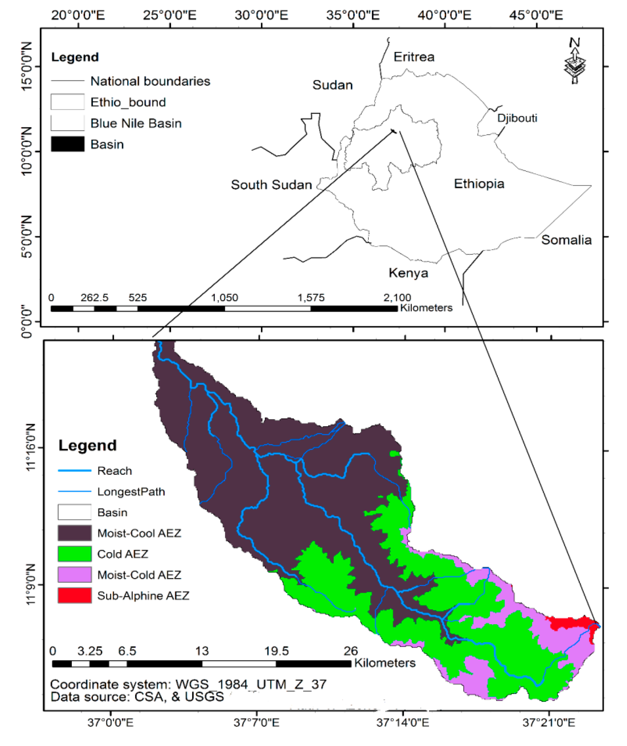
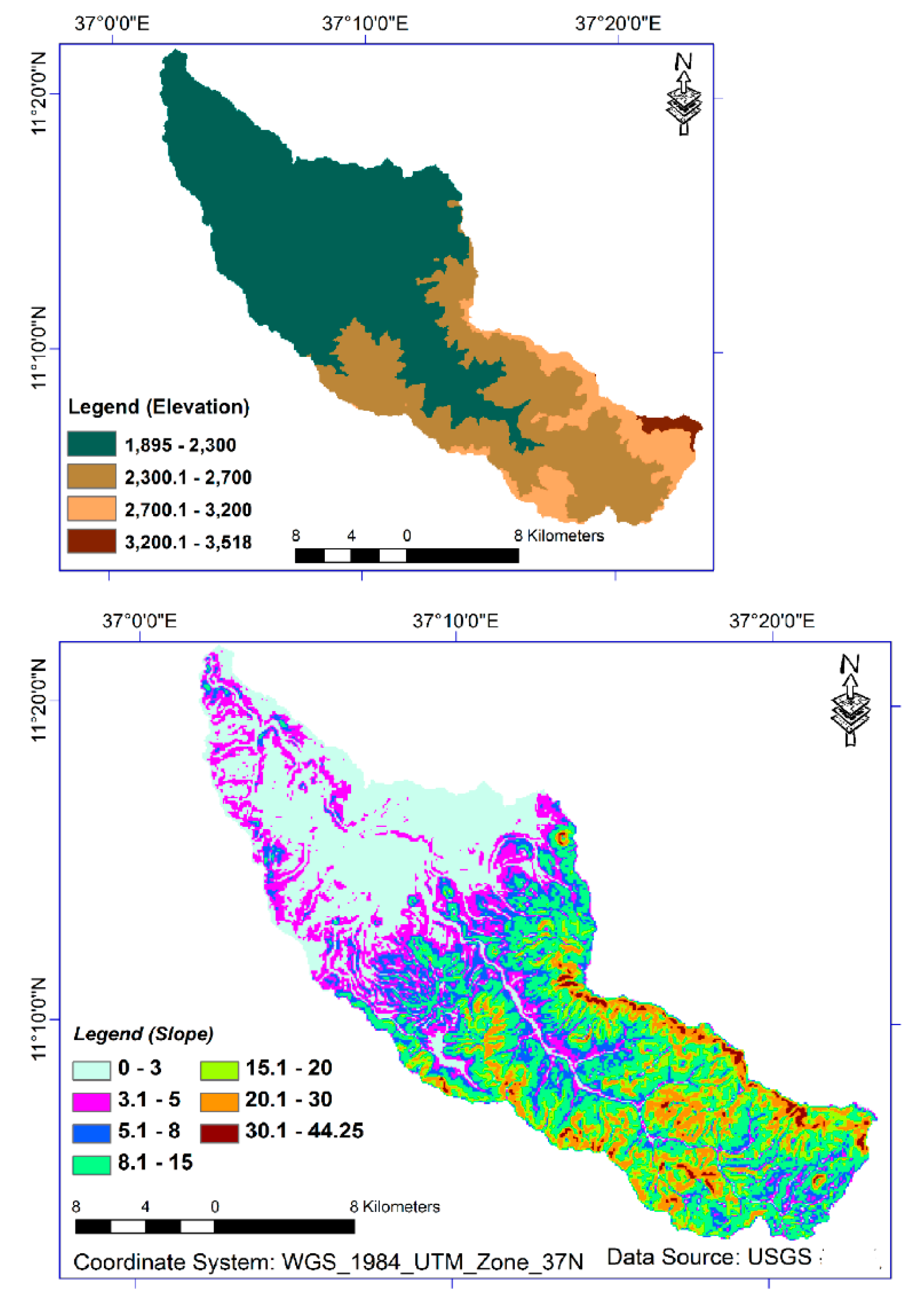
2.1. Jema Watershed
2.2. Data Collection
2.3. Data Analysis
3. Results and Discussion
3.1. Tests of Data Normality
3.2. The Association between Soil Texture and Terrain
4. Conclusions
Author Contributions
Funding
Acknowledgments
Conflicts of Interest
References
- Hartemink, A.E.; McBratney, A. A soil science renaissance. Geoderma 2008, 1482, 123–129. [Google Scholar] [CrossRef]
- Yeshaneh, G.T. Effect of slope position on soil physico-chemical properties with different management practices in small holder cultivated farms of Abuhoy Gara Catchment, Gidan District, North Wollo. Am. J. Environ. Protection 2015, 3, 174–179. [Google Scholar]
- Selassie, Y.G.; Ayanna, G. Effects of different land use systems on selected physico-chemical properties of soils in Northwestern Ethiopia. J. Agric. Sci. 2013, 17, 112. [Google Scholar] [CrossRef]
- Simane, B.; Zaitchik, B.F.; Foltz, J.D. Agroecosystem specific climate vulnerability analysis: Application of the livelihood vulnerability index to a tropical highland region. Mitig. Adapt. Strateg. Glob. Chang. 2016, 21, 39–65. [Google Scholar] [CrossRef]
- Gonzalez, J.; Cook, S.; Oberthur, T. Creating Low-Cost Soil Maps for Tropical Agriculture Using Gaussian Processes. Robotics Institute Centre for Tropical Agriculture Carnegie Mellon University CIAT, 5000 Forbes Ave, Pittsburgh, PA, USA. 2007. Available online: https://www.ri.cmu.edu/pub_files/pub4/gonzalez_juan_pablo_2007_2/gonzalez_juan_pablo_2007_2.pdf (accessed on 20 June 2017).
- Berhanu, B.; Melesse, A.M.; Seleshi, Y. GIS-based hydrological zones and soil geo-data base of Ethiopia. Catena 2013, 104, 21–31. [Google Scholar] [CrossRef]
- Parry, M.L. Climate Change 2007: Impacts, Adaptation and Vulnerability: Contribution of Working Group II to the Fourth Assessment Report of the Intergovernmental Panel on Climate Change Volume 4; Cambridge University Press: Cambridge, UK, 2007. [Google Scholar]
- Zaitchik, B.F.; Simane, B.; Habib, S.; Anderson, M.C.; Ozdogan, M.; Foltz, J.D. Building climate resilience in the Blue Nile/Abay Highlands: A role for earth system sciences. Int. J. Environ. Res. Public Health 2012, 9, 435–461. [Google Scholar] [CrossRef] [PubMed]
- Amsalu, A.; Stroosnijder, L.; de Graaff, J. Long-term dynamics in land resource use and the driving forces in the Beressa watershed, highlands of Ethiopia. J. Environ. Manag. 2007, 83, 448–459. [Google Scholar] [CrossRef] [PubMed]
- Assen, M. Land use/cover dynamics and its implications in the dried Lake Alemaya watershed, eastern Ethiopia. J. Sustain. Dev. Af. 2011, 13, 267–284. [Google Scholar]
- Bewket, W.; Sterk, G. Farmers’ participation in soil and water conservation activities in the Chemoga watershed, Blue Nile basin, Ethiopia. Land Degrad. Dev. 2002, 13, 189–200. [Google Scholar] [CrossRef]
- Hurni, H.; Tato, K.; Zeleke, G. The implications of changes in population, land use, and land management for surface runoff in the upper Nile basin area of Ethiopia. Mt. Res. Dev. 2005, 252, 147–154. [Google Scholar] [CrossRef]
- Setegn, S.G.; Srinivasan, R.; Dargahi, B.; Melesse, A.M. Spatial delineation of soil erosion vulnerability in the Lake Tana Basin, Ethiopia. Hydrol. Process. 2009, 23, 3738–3750. [Google Scholar] [CrossRef]
- Landon, J.R. Booker Tropical soil Manual: A Handbook for Soil Survey and Agricultural Land Evaluation in the Tropics and Subtropics; Longman Scientific and Technical: Essex, UK, 1991; p. 474. [Google Scholar]
- Jahn, R.; Blume, H.P.; Asio, V.B.; Spaargaren, O.; Schad, P. Guidelines for Soil Description. FAO, 2006. Available online: http://www.fao.org/3/a-a0541e.pdf (accessed on 10 June 2017).
- Tromp-van Meerveld, H.J.; McDonnell, J.J. On the interrelations between topography, soil depth, soil moisture, transpiration rates and species distribution at the hillslope scale. Adv. Water Resour. 2006, 29, 293–310. [Google Scholar] [CrossRef]
- USDA: United States Department of Agriculture Soil Survey Staff. Keys to Soil Taxonomy, 9th ed.; Natural Resources Conservation Service, USDA: Washington, DC, USA, 2003; p. 332.
- Chiang, S.L.; Peterson, G.W. Soil catena concept for hydrologic interpretations. J. Soil Water Conserv. 1970, 25, 225–227. [Google Scholar]
- Debella-Gilo, M.; Etzelmüller, B. Spatial prediction of soil classes using digital terrain analysis and multinomial logistic regression modeling integrated in GIS: Examples from Vestfold County, Norway. Catena 2009, 15, 8–18. [Google Scholar] [CrossRef]
- Zeleke, G.; Hurni, H. Implications of land use and land cover dynamics for mountain resource degradation in the Northwestern Ethiopian highlands. Mt. Res. Dev. 2001, 21, 184–191. [Google Scholar] [CrossRef]
- Teferi, E.; Bewket, W.; Simane, B. Effects of land use and land cover on selected soil quality indicators in the headwater area of the Blue Nile basin of Ethiopia. Environ. Monit. Assess. 2016, 188, 83. [Google Scholar] [CrossRef] [PubMed]
- Ceddia, M.B.; Vieira, S.R.; Villela, A.L.; Mota, L.D.; Anjos, L.H.; Carvalho, D.F. Topography and spatial variability of soil physical properties. Sci. Agric. 2009, 66, 338–352. [Google Scholar] [CrossRef]
- Dessalegn, D.; Beyene, S.; Ram, N.; Walley, F.; Gala, T.S. Effects of topography and land use on soil characteristics along the toposequence of Ele watershed in southern Ethiopia. Catena 2014, 115, 47–54. [Google Scholar] [CrossRef]
- Hurni, H. Agroecological Belts of Ethiopia: Explanatory notes on three maps at a scale of 1: 1,000,000. Soil Conservation Research Program of Ethiopia: Addis Ababa, Ethiopia. 1998, p. 31. Available online: https://library.wur.nl/isric/fulltext/isricu_t4d384c8b_001.pdf (accessed on 2 September 2017).
- Poppe, L.; Frankl, A.; Poesen, J.; Admasu, T.; Dessie, M.; Adgo, E.; Deckers, J.; Nyssen, J. Geomorphology of the Lake Tana basin, Ethiopia. J. Maps 2013, 9, 431–437. [Google Scholar] [CrossRef]
- NMA (National Meteorological Agency), Addis Ababa, Ethiopia. 2014. Available online: http://www.ethiomet.gov.et/ (accessed on 15 October 2017).
- FAO. World Reference Base for Soil Resources; Food & Agriculture Organization: Rome, Italy, 1998; Volume 3. [Google Scholar]
- ISRIC. Procedures for Soil Analysis, Technical Paper, 6th ed.; ISRIC: Wageningen, The Netherlands, 2002; ISBN 90-6672-044-1. [Google Scholar]
- Gujarati, D.N. Basic Econometrics; Tata McGraw-Hill Education: Columbus, OH, USA, 2009. [Google Scholar]
- Cresswell, H.P.; Hamilton, G.J. Bulk density and pore space relations. In Soil Physical Measurement and Interpretation for Land Evaluation; McKenzie, N., Coughlan, K., Cresswell, H., Eds.; CSIRO Publishing: Clayton, VIC, Australia, 2002; pp. 35–58. [Google Scholar]
- Tranter, G.; Minasny, B.; McBratney, A.B.; Rossel, R.A.; Murphy, B.W. Comparing spectral soil inference systems and mid-infrared spectroscopic predictions of soil moisture retention. Soil Sci. Soc. Am. J. 2008, 72, 1394–1400. [Google Scholar] [CrossRef]
- Lark, R.M. Soil-landform relationships at within-field scales: An investigation using continuous classification. Geoderma 1999, 92, 141–165. [Google Scholar] [CrossRef]
- Moore, I.D.; Gessler, P.E.; Nielsen, G.A.; Peterson, G.A. Soil attribute prediction using terrain analysis. Soil Sci. Soc. Am. J. 1993, 57, 443–452. [Google Scholar] [CrossRef]
- Kokulan, V.; Akinremi, O.; Moulin, A.P.; Kumaragamage, D. Importance of terrain attributes in relation to the spatial distribution of soil properties at the micro scale: A case study. Can. J. Soil Sci. 2018, 98, 292–305. [Google Scholar] [CrossRef]
- Tesfahunegn, G.B.; Tamene, L.; Vlek, P.L. Catchment-scale spatial variability of soil properties and implications on site-specific soil management in northern Ethiopia. Soil Tillage Res. 2011, 117, 124–139. [Google Scholar] [CrossRef]


| Agro-Ecological Zone | Elevation (m) | Annual Total Rainfall (mm) | Major Crops | Length of Growing Period (Day) |
|---|---|---|---|---|
| Arid lowland (Bereha) | <500 | <900 | sorghum, nug 1 (Guizotia Abyssinica), Dagusa 2 (Eleusine Coracana), groundnut | <120 |
| Dry to Moist Lowland (Kolla) | 500–1500 | 900–1400 | sorghum, nug, groundnut | <120; 120–240 |
| Dry to Wet Cool Highland (Weyna-Dega) | 1500–2300 | >900; 900–1400 | teff 3 (Eragrostis), maize, sorghu, nug, wheat, Dagusa, inset 4 (ventricosum), barley | <120; 120–240 |
| Moist to Wet Cold Highland (Dega) | 2300–2700 | 900–1400; >1400 | barley, wheat & pulse | 120–240; >240 |
| Moist to Wet Alphine (Low-Wurch) | 3200–3700 | 900–1400; >1400 | barley | 120–240; >240 |
| High Alphine (High-Wurch) | >3700 | >1400 | none | >240 |
| Elevation | Kolmogorov-Smirnov a | Shapiro-Wilk | |||||
|---|---|---|---|---|---|---|---|
| Statistic | df | p Value | Statistic | df | p Value | ||
| Clay | Moist-Cool | 0.158 | 14 | 0.200 * | 0.965 | 14 | 0.797 |
| Cold | 0.111 | 12 | 0.200 * | 0.974 | 12 | 0.951 | |
| Moist-Cold | 0.432 | 6 | 0.001 | 0.687 | 6 | 0.005 | |
| Sub-Alphine | 0.306 | 4 | - | 0.768 | 4 | 0.056 | |
| Sand | Moist-Cool | 0.150 | 14 | 0.200 * | 0.949 | 14 | 0.540 |
| Cold | 0.234 | 12 | 0.068 | 0.907 | 12 | 0.194 | |
| Moist-Cold | 0.216 | 6 | 0.200 * | 0.874 | 6 | 0.245 | |
| Sub-Alphine | 0.283 | 4 | - | 0.863 | 4 | 0.272 | |
| Silt | Moist-Cool | 0.234 | 14 | 0.037 | 0.885 | 14 | 0.068 |
| Cold | 0.117 | 12 | 0.200 * | 0.961 | 12 | 0.796 | |
| Moist-Cold | 0.178 | 6 | 0.200 * | 0.979 | 6 | 0.946 | |
| Sub-Alpine | 0.304 | 4 | - | 0.811 | 4 | 0.123 | |
| Groups | Df | Slope | df | Elevation | |
|---|---|---|---|---|---|
| p Value | p Value | ||||
| Clay % | Between Groups | 5 | 0.023 | 3 | 0.00 |
| Within Groups | 30 | 32 | |||
| Total | 35 | 35 | |||
| Silt % | Between Groups | 5 | 0.158 | 3 | 0.27 |
| Within Groups | 30 | 32 | |||
| Total | 35 | 35 | |||
| Sand % | Between Groups | 5 | 0.047 | 3 | 0.00 |
| Within Groups | 30 | 32 | |||
| Total | 35 | 35 | |||
| Model | Unstandardized Coefficients | Standardized Coefficients | t | p Value | ||
|---|---|---|---|---|---|---|
| B | Std. Error | Beta | ||||
| 1 | (Constant) | 68.519 | 4.571 | 14.990 | 0.000 | |
| Slope | −4.413 | 1.315 | −0.499 | −3.356 | 0.002 | |
| 2 | (Constant) | 76.689 | 3.496 | 21.939 | 0.000 | |
| Elevation (m) | −10.889 | 1.563 | −0.767 | −6.966 | 0.000 | |
| Model | Unstandardized Coefficients | Standardized Coefficients | t | p Value | ||
|---|---|---|---|---|---|---|
| B | Std. Error | Beta | ||||
| 1 | (Constant) | 16.449 | 2.674 | 6.152 | 0.000 | |
| Slope (%) | 1.553 | 0.769 | 0.327 | 2.020 | 0.051 | |
| 2 | (Constant) | 14.641 | 2.634 | 5.559 | 0.000 | |
| Elevation (m) | 3.299 | 1.178 | 0.433 | 2.801 | 0.008 | |
| Model | Unstandardized Coefficients | Standardized Coefficients | t | p Value | ||
|---|---|---|---|---|---|---|
| B | Std. Error | Beta | ||||
| 1 | (Constant) | 15.037 | 3.056 | 4.920 | 0.000 | |
| Slope (%) | 2.843 | 0.879 | 0.485 | 3.233 | 0.003 | |
| 2 | (Constant) | 8.525 | 2.107 | 4.046 | 0.000 | |
| Elevation (m) | 7.638 | 0.942 | 0.812 | 8.107 | 0.000 | |
© 2018 by the authors. Licensee MDPI, Basel, Switzerland. This article is an open access article distributed under the terms and conditions of the Creative Commons Attribution (CC BY) license (http://creativecommons.org/licenses/by/4.0/).
Share and Cite
Taye, M.; Simane, B.; Selsssie, Y.G.; Zaitchik, B.; Setegn, S. Analysis of the Spatial Variability of Soil Texture in a Tropical Highland: The Case of the Jema Watershed, Northwestern Highlands of Ethiopia. Int. J. Environ. Res. Public Health 2018, 15, 1903. https://doi.org/10.3390/ijerph15091903
Taye M, Simane B, Selsssie YG, Zaitchik B, Setegn S. Analysis of the Spatial Variability of Soil Texture in a Tropical Highland: The Case of the Jema Watershed, Northwestern Highlands of Ethiopia. International Journal of Environmental Research and Public Health. 2018; 15(9):1903. https://doi.org/10.3390/ijerph15091903
Chicago/Turabian StyleTaye, Mintesinot, Belay Simane, Yihenew G. Selsssie, Benjamin Zaitchik, and Shimelis Setegn. 2018. "Analysis of the Spatial Variability of Soil Texture in a Tropical Highland: The Case of the Jema Watershed, Northwestern Highlands of Ethiopia" International Journal of Environmental Research and Public Health 15, no. 9: 1903. https://doi.org/10.3390/ijerph15091903
APA StyleTaye, M., Simane, B., Selsssie, Y. G., Zaitchik, B., & Setegn, S. (2018). Analysis of the Spatial Variability of Soil Texture in a Tropical Highland: The Case of the Jema Watershed, Northwestern Highlands of Ethiopia. International Journal of Environmental Research and Public Health, 15(9), 1903. https://doi.org/10.3390/ijerph15091903