Community-Based Health and Exposure Study around Urban Oil Developments in South Los Angeles
Abstract
1. Introduction
2. Methods
2.1. Neighborhood Profile
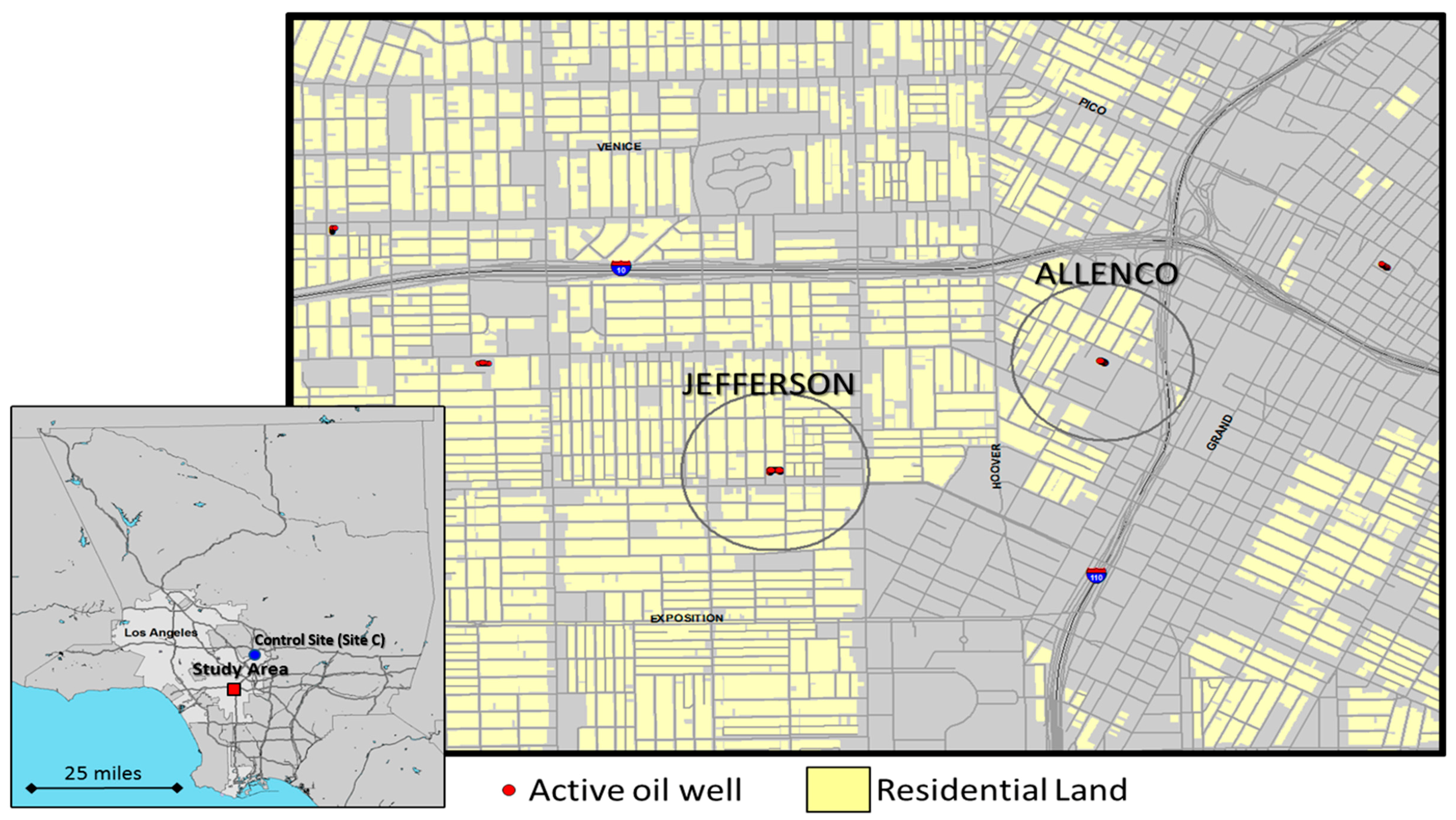
2.2. Study Area and Sample Selection
2.3. Survey Instrument
2.4. CBPR Method for Administration of Resident Surveys: Data Collection and Community Building
2.5. Survey Analysis
2.5.1. Health Insurance
2.5.2. Asthma and Asthmatic Hospitalization Rate
2.6. Air Quality Monitoring with Low Cost Sensors
3. Results
3.1. Demographics
3.2. Community Knowledge and Experiences
3.3. Reported Health Symptoms
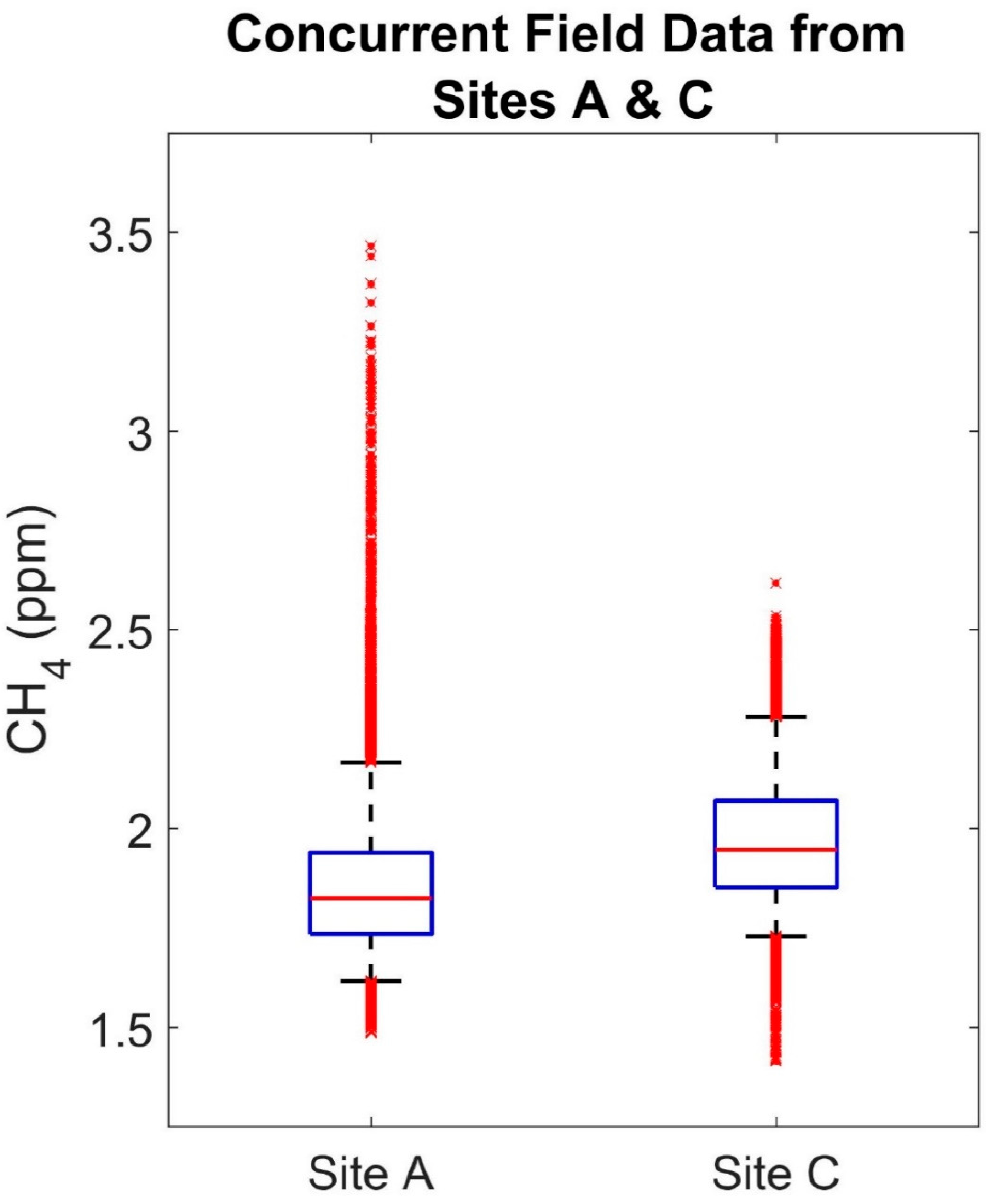
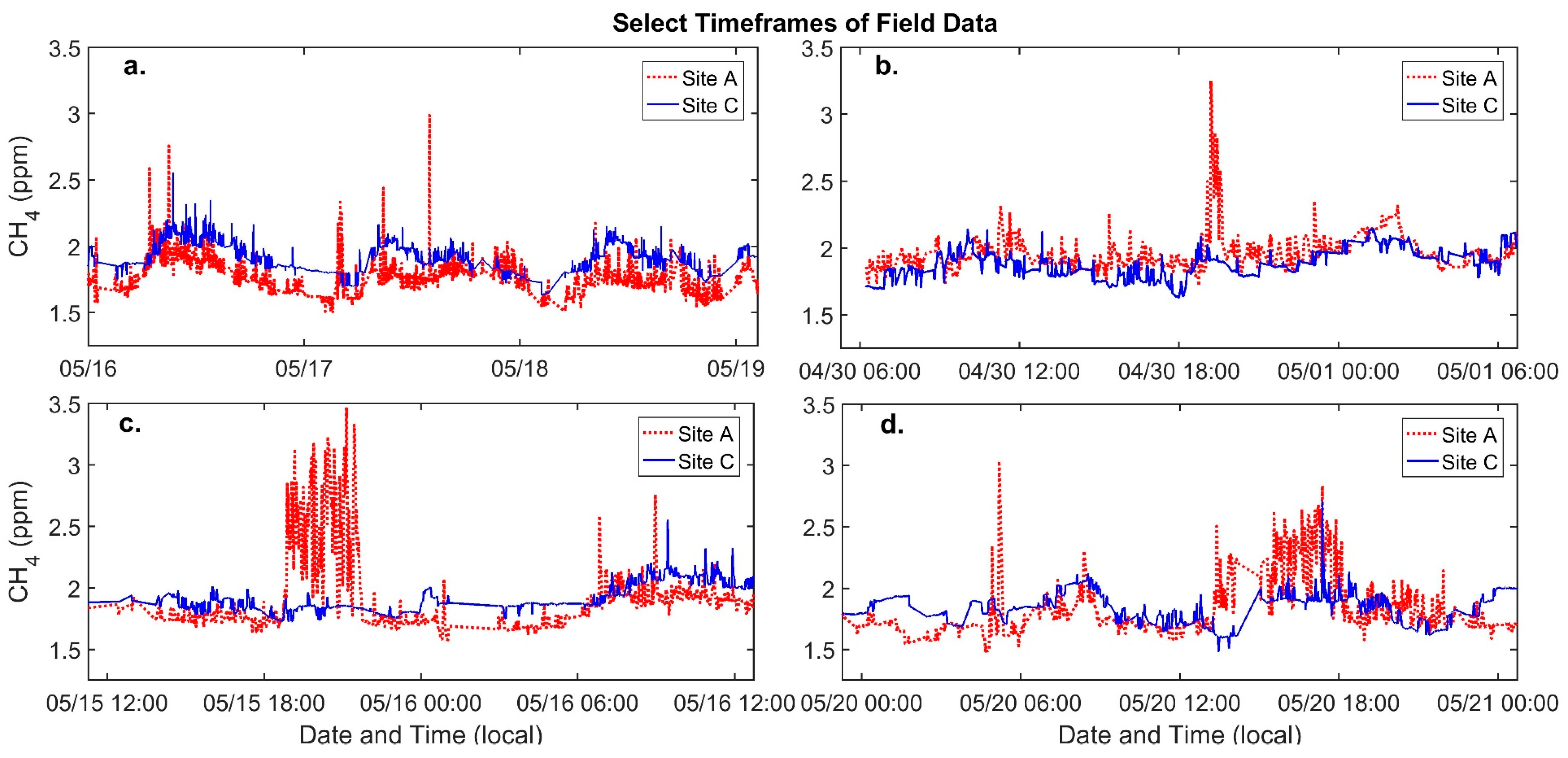
3.4. Low-Cost Sensor Calibration and Field Data
4. Discussion
Air Quality Monitoring
5. Conclusions
Acknowledgments
Author Contributions
Conflicts of Interest
References
- Shonkoff, S.B.; Hays, J.; Finkel, M.L. Environmental public health dimensions of shale and tight gas development. Environ. Health Perspect. 2014, 122. [Google Scholar] [CrossRef] [PubMed]
- Penning, T.M.; Breysse, P.N.; Gray, K.; Howarth, M.; Yan, B. Environmental health research recommendations from the inter-environmental health sciences core center working group on unconventional natural gas drilling operations. Environ. Health Perspect. 2014, 122. [Google Scholar] [CrossRef] [PubMed]
- Balazs, C.L.; Morello-Frosch, R. The three R’s: How community-based participatory research strengthens the rigor, relevance, and reach of science. Environ. Justice 2013, 6, 9–16. [Google Scholar] [CrossRef] [PubMed]
- Meng, Q.; Ashby, S. Distance: A critical aspect for environmental impact assessment of hydraulic fracking. Extr. Ind. Soc. 2014, 1, 124–126. [Google Scholar] [CrossRef]
- McKenzie, L.M.; Guo, R.; Witter, R.Z.; Savitz, D.A.; Newman, L.S.; Adgate, J.L. Birth outcomes and maternal residential proximity to natural gas development in Rural Colorado. Environ. Health Perspect. 2014, 122. [Google Scholar] [CrossRef] [PubMed]
- Rabinowitz, P.M.; Slizovskiy, I.B.; Lamers, V.; Trufan, S.J.; Holford, T.R.; Dziura, J.D.; Peduzzi, P.N.; Kane, M.J.; Reif, J.S.; Weiss, T.R.; et al. Proximity to natural gas wells and reported health status: Results of a household survey in Washington County, Pennsylvania. Environ. Health Perspect. 2015, 123. [Google Scholar] [CrossRef] [PubMed]
- Chilingar, G.V.; Endres, B. Environmental hazards posed by the Los Angeles Basin Urban Oilfields: An historical perspective of lessons learned. Environ. Geol. 2005, 47, 302–317. [Google Scholar] [CrossRef]
- Division of Oil, Gas & Geothermal Resources. (DOGGR) Well Finder. Available online: http://www.conservation.ca.gov/dog (accessed on 8 August 2016).
- Sadd, J.; Shamasunder, B. Oil Extraction in Los Angeles: Health, Land Use, and Environmental Justice Consequence. In Drilling Down: The Community Consequences of Expanded Oil Development in Los Angeles; Liberty Hill Foundation: Los Angeles, CA, USA, 2015; pp. 7–14. [Google Scholar]
- Quam-Wickham, N. “Cities sacrificed on the altar of oil”: Popular opposition to oil development, in 1920s Los Angeles. Environ. Hist. 1998, 3, 189–209. [Google Scholar] [CrossRef]
- Community & Tribal Programs Group & Ambient Air Monitoring Group. Technical Guidance for the Development of Tribal Air Monitoring Programs; Community & Tribal Programs Group & Ambient Air Monitoring Group: The Research Triangle, NC, USA, 2007.
- Morello-Frosch, R.; Shenassa, E.D. The environmental “riskscape” and social inequality: Implications for explaining maternal and child health disparities. Environ. Health Perspect. 2006, 114, 1150–1153. [Google Scholar] [CrossRef] [PubMed]
- Morello-Frosch, R.; Pastor, M.; Sadd, J. Environmental justice and Southern California’s “Riskscape” the distribution of air toxics exposures and health risks among diverse communities. Urban Aff. Rev. 2001, 36, 551–578. [Google Scholar] [CrossRef]
- Office of Environmental Health Hazard Assessment (OEHHA). CalEnviroScreen 3.0. Available online: https://oehha.ca.gov/calenviroscreen/report/calenviroscreen-30 (accessed on 7 June 2017).
- California Environmental Protection Agency. Designation of Disadvantaged Communities Pursuant to Senate Bill 535 (De Leon); California Environmental Protection Agency: Sacramento, CA, USA, 2017.
- Cole, L.W.; Foster, S. From the Ground up: Environmental Racism and the Rise of the Environmental Justice Movement; New York University Press: New York, NY, USA, 2001; ISBN 0-8147-1537-0. [Google Scholar]
- Brown, P. Popular epidemiology and toxic waste contamination: Lay and professional ways of knowing. J. Health Soc. Behav. 1992, 33, 267–281. [Google Scholar] [CrossRef] [PubMed]
- Corburn, J. Combining community-based research and local knowledge to confront asthma and subsistence-fishing hazards in Greenpoint/Williamsburg, Brooklyn, New York. Environ. Health Perspect. 2002, 110, 241–248. [Google Scholar] [CrossRef] [PubMed]
- Witter, R.Z.; McKenzie, L.; Stinson, K.E.; Scott, K.; Newman, L.S.; Adgate, J. The use of health impact assessment for a community undergoing natural gas development. Am. J. Public Health 2013, 103, 1002–1010. [Google Scholar] [CrossRef] [PubMed]
- Macey, G.P.; Breech, R.; Chernaik, M.; Cox, C.; Larson, D.; Thomas, D.; Carpenter, D.O. Air concentrations of volatile compounds near oil and gas production: A community-based exploratory study. Environ. Health 2014, 13. [Google Scholar] [CrossRef] [PubMed]
- Abdullah, K.; Malloy, T.; Stenstrom, M.K.; Suffet, I.H. (Mel) Toxicity of acidization fluids used in California oil exploration. Toxicol. Environ. Chem. 2017, 99, 78–94. [Google Scholar] [CrossRef]
- Stringfellow, W.T.; Camarillo, M.K.; Domen, J.K.; Sandelin, W.L.; Varadharajan, C.; Jordan, P.D.; Reagan, M.T.; Cooley, H.; Heberger, M.G.; Birkholzer, J.T. Identifying chemicals of concern in hydraulic fracturing fluids used for oil production. Environ. Pollut. 2017, 220, 413–420. [Google Scholar] [CrossRef] [PubMed]
- Sahagun, L. Chemical odor, kids’ nosebleeds, few answers in South L.A. Neighborhood. Los Angeles Times, 2013; 1–2. [Google Scholar]
- Haley, M.; McCawley, M.; Epstein, A.C.; Arrington, B.; Bjerke, E.F. Adequacy of current state setbacks for directional high-volume hydraulic fracturing in the Marcellus, Barnett, and Niobrara Shale Plays. Environ. Health Perspect. 2016, 124. [Google Scholar] [CrossRef] [PubMed]
- Fry, M. Urban gas drilling and distance ordinances in the Texas Barnett Shale. Energy Policy 2013, 62, 79–89. [Google Scholar] [CrossRef]
- Guerin, E. LA to Study Banning Oil Production around Homes, Schools, Hospitals and Other Public Places. 2017. Available online: http://www.scpr.org/news/2017/04/19/70946/la-to-study-banning-oil-production-around-homes-sc/ (accessed on 13 November 2017).
- California Air Resources Board. Air Quality and Land Use Handbook: A Community Health Perspective; California Environmental Protection Agency: Sacramento, CA, USA, 2005.
- Lewis, A.C.; Lee, J.D.; Edwards, P.M.; Shaw, M.D.; Evans, M.J.; Moller, S.J.; Smith, K.R.; Buckley, J.W.; Ellis, M.; Gillot, S.R.; et al. Evaluating the performance of low cost chemical sensors for air pollution research. Faraday Discuss 2016, 189, 85–103. [Google Scholar] [CrossRef] [PubMed]
- Snyder, E.G.; Watkins, T.H.; Solomon, P.A.; Thoma, E.D.; Williams, R.W.; Hagler, G.S.W.; Shelow, D.; Hindin, D.A.; Kilaru, V.J.; Preuss, P.W. The changing paradigm of air pollution monitoring. Environ. Sci. Technol. 2013, 47, 11369–11377. [Google Scholar] [CrossRef] [PubMed]
- Masson, N.; Piedrahita, R.; Hannigan, M. Approach for quantification of metal oxide type semiconductor gas sensors used for ambient air quality monitoring. Sens. Actuators B Chem. 2015, 208, 339–345. [Google Scholar] [CrossRef]
- Jovašević-Stojanović, M.; Bartonova, A.; Topalović, D.; Lazović, I.; Pokrić, B.; Ristovski, Z. On the use of small and cheaper sensors and devices for indicative citizen-based monitoring of respirable particulate matter. Environ. Pollut. 2015, 206, 696–704. [Google Scholar] [CrossRef] [PubMed]
- Piedrahita, R.; Xiang, Y.; Masson, N.; Ortega, J.; Collier, A.; Jiang, Y.; Li, K.; Dick, R.P.; Lv, Q.; Hannigan, M.; et al. The next generation of low-cost personal air quality sensors for quantitative exposure monitoring. Atmos. Meas. Tech. 2014, 7, 3325–3336. [Google Scholar] [CrossRef]
- Mead, M.I.; Popoola, O.A.M.; Stewart, G.B.; Landshoff, P.; Calleja, M.; Hayes, M.; Baldovi, J.J.; McLeod, M.W.; Hodgson, T.F.; Dicks, J.; et al. The use of electrochemical sensors for monitoring urban air quality in low-cost, high-density networks. Atmos. Environ. 2013, 70, 186–203. [Google Scholar] [CrossRef]
- Eugster, W.; Kling, G.W. Performance of a low-cost methane sensor for ambient concentration measurements in preliminary studies. Atmos. Meas. Tech. 2012, 5, 1925–1934. [Google Scholar] [CrossRef]
- Loftis, R.L. Dallas OKs Gas Drilling Rules That Are among Nation’s Tightest. Dallas Morning News. 11 December 2013. Available online: https://www.dallasnews.com/news/news/2013/12/11/dallas-oks-gas-drilling-rules-that-are-among-nations-tightest (accessed on 10 August 2017).
- Cohen, A.K.; Lopez, A.; Malloy, N.; Morello-Frosch, R. Surveying for environmental health justice: Community organizing applications of community-based participatory research. Environ. Justice 2016, 9, 129–136. [Google Scholar] [CrossRef]
- Minkler, M.; Garcia, A.P.; Williams, J.; LoPresti, T.; Lilly, J. Sí Se Puede: Using participatory research to promote environmental justice in a Latino Community in San Diego, California. J. Urban Health 2010, 87, 796–812. [Google Scholar] [CrossRef] [PubMed]
- U.S. Census Bureau. American Community Survey 5-Year Dataset 2009–2013; U.S. Census Bureau: Suitland, MD, USA, 2014.
- Masson, N.; Piedrahita, R.; Hannigan, M. Quantification method for electrolytic sensors in long-term monitoring of ambient air quality. Sensors 2015, 15, 27283–27302. [Google Scholar] [CrossRef] [PubMed]
- Spinelle, L.; Gerboles, M.; Villani, M.G.; Aleixandre, M.; Bonavitacola, F. Field calibration of a cluster of low-cost available sensors for air quality monitoring. Part A: Ozone and nitrogen dioxide. Sens. Actuators B Chem. 2015, 215, 249–257. [Google Scholar] [CrossRef]
- Collier-Oxandale, A.; Hannigan, M.; Casey, J.G.; Piedrahita, R.; Johnston, J. Assessing a low-cost methane sensor quantification system for use in complex rural and urban environments. Atmos. Meas. Tech. 2018. [Google Scholar] [CrossRef]
- UCLA Center for Health Policy Research Type of Current Health Insurance Coverage (Los Angeles, SPA South). Available online: http://ask.chis.ucla.edu (accessed on 21 June 2017).
- UCLA Center for Health Policy Research AskCHIS 2015. Ever Diagnosed with Asthma (Los Angeles, SPA South). Available online: http://ask.chis.ucla.edu (accessed on 21 June 2017).
- UCLA Center for Health Policy Research AskCHIS 2015. Had Emergency Room/Urgent Care Visit for Asthma within Past 12 Months (Current Asthmatics) (Los Angeles, SPA South). Available online: http://ask.chis.ucla.edu (accessed on 6 June 2017).
- Thompson, T.M.; Shepherd, D.; Stacy, A.; Barna, M.G.; Schichtel, B.A. Modeling to evaluate contribution of oil and gas emissions to air pollution. J. Air Waste Manag. Assoc. 2017, 67, 445–461. [Google Scholar] [CrossRef] [PubMed]
- Webb, E.; Hays, J.; Dyrszka, L.; Rodriguez, B.; Cox, C.; Huffling, K.; Bushkin-Bedient, S. Potential hazards of air pollutant emissions from unconventional oil and natural gas operations on the respiratory health of children and infants. Rev. Environ. Health 2016, 31, 225–243. [Google Scholar] [CrossRef] [PubMed]
- Rasmussen, S.G.; Ogburn, E.L.; McCormack, M.; Casey, J.A.; Bandeen-Roche, K.; Mercer, D.G.; Schwartz, B.S. Association between unconventional natural gas development in the Marcellus Shale and Asthma Exacerbations. JAMA Intern. Med. 2016, 176, 1334–1343. [Google Scholar] [CrossRef] [PubMed]
- Berhane, K.; Chang, C.-C.; McConnell, R.; Gauderman, W.J.; Avol, E.; Rapapport, E.; Urman, R.; Lurmann, F.; Gilliland, F. Association of changes in air quality with bronchitic symptoms in children in California, 1993–2012. JAMA 2016, 315, 1491–1501. [Google Scholar] [CrossRef] [PubMed]
- Bamberger, I.; Stieger, J.; Buchmann, N.; Eugster, W. Spatial variability of methane: Attributing atmospheric concentrations to emissions. Environ. Pollut. 2014, 190, 65–74. [Google Scholar] [CrossRef] [PubMed]
- Sadd, J.L.; Pastor, M.; Morello-Frosch, R.; Scoggins, J.; Jesdale, B. Playing it safe: Assessing cumulative impact and social vulnerability through an environmental justice screening method in the South Coast Air Basin, California. Int. J. Environ. Res. Public Health 2011, 8, 1441–1459. [Google Scholar] [CrossRef] [PubMed]


| Location | Number of Schools | Childcare Facilities | Schools per 10,000 People | Childcare per 10,000 People | Childcare per sq. Mile |
|---|---|---|---|---|---|
| L.A. County | 3036 | 3903 | 3.09 | 3.98 | 1.6 |
| L.A. City | 1087 | 1385 | 2.88 | 3.67 | 2.9 |
| Within 1500 ft. of an active L.A. City Well | 40 | 29 | 3.25 | 2.35 | 1.5 |
| University Park: AllenCo | 5 | 2 | 7.83 | 3.13 | 8.0 |
| Historic West Adams: Jefferson | 1 | 2 | 1.29 | 2.59 | 8.0 |
| Historic West Adams: Murphy | 3 | 1 | 5.44 | 1.81 | 4.0 |
| Wilmington: Warren E&P | 0 | 1 | 0.00 | 2.35 | 2.4 |
| Baldwin Hills: Inglewood Oil Field | 2 | 7 | 3.64 | 2.35 | 4.4 |
| Population | West Adams Buffer Area 1500 ft. around Jefferson Oil Field | University Park Buffer Area, 1500 ft. around AllenCo Oil Field | City of Los Angeles |
|---|---|---|---|
| Total Population | 6641 | 5401 | 2,546,606 |
| % Age 5 or under | 20.90% | 5.31% | 7.63% |
| % Age 65 or older | 9.92% | 6.94% | 6.95% |
| % People of Color | 87.82% | 84.17% | 72.85% |
| % Non-Hispanic Black | 20.86% | 8.17% | 9.99% |
| % Non-Hispanic White | 12.18% | 15.83% | 27.15% |
| % Hispanic | 58.20% | 76.00% | 50.85% |
| % Linguistically Isolated | 23.42% | 39.21% | 12.37% |
| % Less Than High School | 42.49% | 46.72% | 18.91% |
| Per Capita Income | $11,194 | $11,203 | $18,839 |
| Median Household Income | $23,912 | $20,115 | $37,723 |
| Poverty (LT 150%) | 51.51% | 59.39% | 20.57% |
| Poverty (LT 200%) | 64.88% | 72.30% | 27.57% |
| % Renters | 68.77% | 81.13% | 34.70% |
| Median Household Size | 2.7 | 3.4 | 1.7 |
© 2018 by the authors. Licensee MDPI, Basel, Switzerland. This article is an open access article distributed under the terms and conditions of the Creative Commons Attribution (CC BY) license (http://creativecommons.org/licenses/by/4.0/).
Share and Cite
Shamasunder, B.; Collier-Oxandale, A.; Blickley, J.; Sadd, J.; Chan, M.; Navarro, S.; Hannigan, M.; Wong, N.J. Community-Based Health and Exposure Study around Urban Oil Developments in South Los Angeles. Int. J. Environ. Res. Public Health 2018, 15, 138. https://doi.org/10.3390/ijerph15010138
Shamasunder B, Collier-Oxandale A, Blickley J, Sadd J, Chan M, Navarro S, Hannigan M, Wong NJ. Community-Based Health and Exposure Study around Urban Oil Developments in South Los Angeles. International Journal of Environmental Research and Public Health. 2018; 15(1):138. https://doi.org/10.3390/ijerph15010138
Chicago/Turabian StyleShamasunder, Bhavna, Ashley Collier-Oxandale, Jessica Blickley, James Sadd, Marissa Chan, Sandy Navarro, Michael Hannigan, and Nicole J. Wong. 2018. "Community-Based Health and Exposure Study around Urban Oil Developments in South Los Angeles" International Journal of Environmental Research and Public Health 15, no. 1: 138. https://doi.org/10.3390/ijerph15010138
APA StyleShamasunder, B., Collier-Oxandale, A., Blickley, J., Sadd, J., Chan, M., Navarro, S., Hannigan, M., & Wong, N. J. (2018). Community-Based Health and Exposure Study around Urban Oil Developments in South Los Angeles. International Journal of Environmental Research and Public Health, 15(1), 138. https://doi.org/10.3390/ijerph15010138


