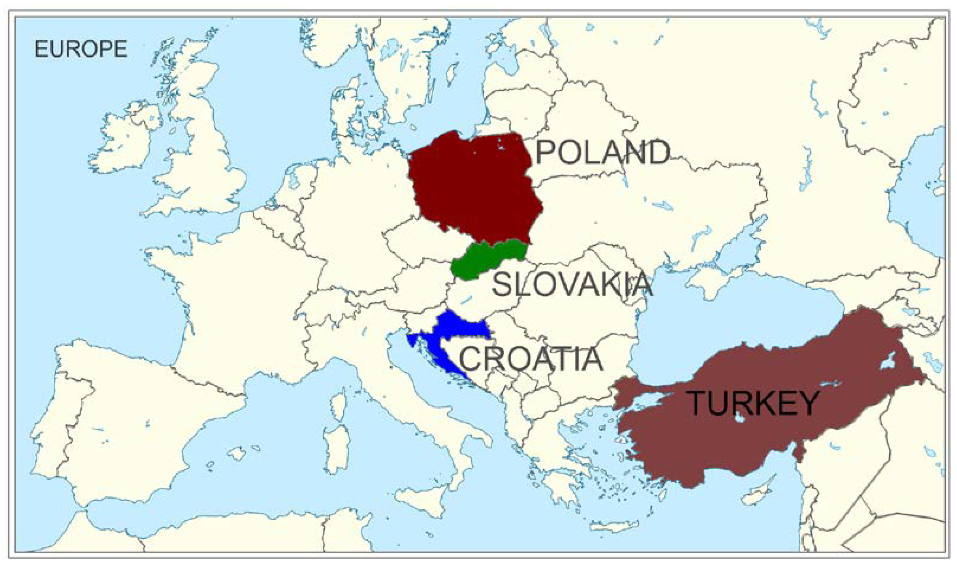
1. Introduction
The profitability of agricultural production is determined by numerous factors, among which soil quality, climatic factors and land fragmentation (LF) parameters are considered the most important. The latter factor results in reduced or unprofitable agricultural production even in areas with relatively good quality of soil. Specifically, it involves the cultivation of small plots of land well away from farm buildings. As a result, excessive land fragmentation negatively affects the standard of life for the population living in rural areas [
1], being at the same time one of the factors causing the phenomenon of permanent abandonment of agricultural land cultivation, often observed in conjunction with the depopulation of rural areas [
2,
3].
Land consolidation (LC) is widely considered to be an effective tool that can remodel the layout of property boundaries in agricultural areas in a short period of time, leading to significant improvements in the spatial layout of farmland. Land consolidation projects comprise a series of operations with a technical, administrative and legal nature which allow for the reorganisation of existing land ownership borders within a given area. This process is usually associated with a series of investment operations which improve the functioning of farms and the quality of life of the local community. The main effect of these projects in terms of agriculture involves the creation of a parcel with a larger area and more favourable shapes, as well as bringing these parcels (to the extent possible) closer to farm buildings. These measures have been successful in preventing land fragmentation and increasing agricultural productivity in numerous European and Asian countries, and their application has also commenced in Africa [
4]. These projects further enable comprehensive rural reorganisation and sustainable development [
5], rural vitalisation [
6,
7], landscaping [
8] and increasing food security [
9,
10].
Land consolidation projects (LCPs) are carried out in different ways in different countries. The reason for this is the different legal regulations and traditions for completing these tasks pursuant to a number of social and historical conditions. Over the years, attempts have been made to develop methods to assist in the implementation of the various stages of land consolidation projects, aimed at reducing the time of their implementation, reducing costs and improving quality. Specifically, this includes the development of land valuation (LV) methods for LCP implementation [
11,
12,
13,
14,
15,
16]. However, the universality of the results of this research in supporting the LV process is significantly limited. This results from the aforementioned different conditions for the implementation of these tasks, but also the lack of broader knowledge of the implementation specifics concerning this task in different countries.
As a result of an LC project, landowners receive land in a different location to that which they owned before the project started. Nevertheless, the value of the land determined by accepted principles but, importantly, also as perceived by the owners, should be identical or close to the initial value, after any deduction for common infrastructure [
17]. As such, one of the key and sometimes considered the most difficult stages of land consolidation projects is the land valuation process for land consolidation implementation. Developing and proposing landowner-acceptable principles for such valuation [
18] is critical to the duration and quality of the overall project. The sense of fairness with regard to the adopted principles of determining the land value is in fact the key to the acceptance of land received in a completely different place in relation to the plots owned before, and thus to the positive evaluation of the entire project and reduction in the number of protests and complaints about its effects.
In any country implementing LC projects, regulations should indicate a method to assign a value (most often relative, occasionally market value) based on soil quality, factors affecting the profitability of agricultural production and a variety of other factors depending on country circumstances. The result of this activity is the determination of the value of all plots and other elements located in the project area, including trees, permanent perennial crops, wells and buildings [
13,
14,
19]. The valuation process usually requires a combination of expert knowledge combined with knowledge of local conditions affecting the value of the land as perceived by its owners [
16]. As a result, this valuation is usually performed by agronomists, appraisers and landowner representatives under the direction of a land consolidation designer.
Unlike mass land valuation models used for market value or tax purposes, the purpose of land valuation in land consolidation projects is to determine the relative value between lands of different quality, location and type of use. This ensures the acceptance of changes in land location during LC, which is often combined with a change in area due to the need to maintain an identical or similar initial value. Factors defining land value may vary from country to country or region to region, and the adopted regulations may also change frequently within individual countries [
14]. Currently, there are two types of values used to consolidate land: market value and agricultural value [
16]. Open market value is the estimated purchase and sale price of a property between a willing buyer and a willing seller at the valuation date, on arm’s length terms, with sufficient knowledge and attention of the parties, and under no duress [
20]. In contrast, agricultural value refers to the value of land based solely on agricultural productivity and soil quality. While agricultural value is more important in countries such as Germany and the Netherlands, countries such as Moldova and Cyprus consider market value to be more important [
16,
19].
Land valuation for LC can be considered as a process of estimating the productive capacity of land, in which a comparison of distinct land types and characteristics is performed [
21]. This topic—because of its importance to the LC implementation process—has been the subject of many previous studies [
13,
16]. However, due to the lack of fully satisfactory results, new approaches are still being proposed in this area, including the use of machine learning methods [
22,
23], analytic hierarchy process (AHP) methods [
24], artificial neural networks [
25], hedonic pricing models based on linear and nonlinear functions [
11], fuzzy logic [
15], multicriteria models [
12,
14,
26] and cluster-based methods [
27]. Capturing data on agricultural land values also has broader applications than just implementing land consolidation projects. Property value data and the development of methods to determine them are an important part of modern land management systems [
28]. The ever-increasing availability of data, their thematic scope and the development of software are creating indications for building complex expert systems related to mass valuation based on big data processing and geographic information systems [
15,
25,
29], which provides an opportunity to better weigh diverse geospatial factors [
24], also using geographically weighted regression [
19].
Most of the existing LV studies for LCP implementation point out the disadvantages of existing approaches and emphasise the need to develop new land estimation models for LC. The main drawback of the existing solutions is their low versatility, the reason for this being the wide variety of possible ways of accomplishing this task, as well as the lack of information on the methods used in practice to solve this problem more broadly than for a single country. Filling this knowledge gap was the primary objective of this study, and for this purpose data were collected on the legal, procedural and technical aspects of land valuation for land consolidation projects in four different countries. Specifically, the study conducted was designed to answer the following questions: To what extent do the legal and procedural regulations in use in individual countries for the determination of the value of land in the process of land consolidation vary? How are the units for determination of this value themselves determined? Are the sets of properties of land taken into consideration similar to one another? What is the scope of public participation in the process of land valuation? Based on the observed similarities and differences, is it possible to formulate conclusions and best practices which would be useful in the process of formulating a universal method of land valuation? The analysis of these data and the results of the discussion should allow one to improve the quality of the proposed algorithms and approaches proposed to automate the LV process, and to increase their versatility by considering diverse organisational and legal considerations.
5. Discussion
The analysis conducted allowed for the systematisation of information regarding similarities and differences in the process of land valuation for the purposes of land consolidation in four diverse countries. This provides a basis for a discussion on the issue of the content of relevant legal regulations, the diversity in approaches to land valuation, the properties of land taken into consideration, and the scope of public participation in the process. For the purposes of the discussion, each of these issues was treated in a separate subsection. The discussion concludes with an analysis of the possibilities of formulating certain best practices in terms of designing universal algorithms for land valuation for currently developing methods for the automation of the process of land consolidation.
5.1. Legal and Procedural Considerations
The process of land valuation performed in connection with the implementation of LC projects is, as such, only a part of the entire system of legal, technical and organisational regulations in force in a given country. The presentation of the results and the discussion should therefore start with the background related to the legal conditions of the LV process and with an indication of the main differences in this respect. Indeed, any attempt to create universal LV algorithms cannot ignore the regulatory content of the acceptable ways to accomplish this task or the necessary factors to consider.
In all four analysed countries, the implementation of LC projects is standardised at the level of the highest legal act—in the form of a law. However, in each case, a major problem is the lack of constancy of the rules over time. In the cases of Croatia and Turkey, new legislation has been introduced relatively frequently, while in the case of Slovakia and Poland, legislation enacted many years ago (in 1991 and 1982, respectively) is updated with great frequency. Frequent changes in regulations indicate that the right LV model—and even the entire method of implementing land consolidation projects—is still at the stage of searching for the optimum solutions in these countries.
In the case of Polish regulations, all provisions concerning the implementation of the LCP are contained in the short Act on Land Consolidation and Exchange of 1982. In this document, the LV issue only includes a description of the administrative procedure for creating value maps (how to appoint committees, how and when to vote on proposals and the effects of land valuation), but the rules for creating such maps and the rules for valuation are not specified because—according to the text of the law—these rules are subject to resolutions of a meeting of all landowners. The subsequent land valuation process is carried out on the basis of previously adopted rules by a Commission consisting of representatives of landowners, the project-implementing institution, representatives of the local administration body, and representatives of agricultural organisations (if there are any in the project area). Such provisions result in theoretically arbitrary variation in the valuation rules, whether in terms of the source materials used, the characteristics considered, or the strength of their influence. Nevertheless, despite the aforementioned freedom in setting valuation rules, in practice these rules are similar throughout Poland. This is determined by the fact that the consolidation projects are carried out by specialised local government units (state units before 1991), which have been cooperating to develop common rules for the implementation of these projects since the 1960s. They customarily propose and consult with the local community on the principles of land valuation, building on established national patterns. They are based on land quality data known to landowners, which are part of cadastral data bases and are used for tax assessment purposes.
In the case of Slovakia, land valuation regulations are separated into a general part, specified in the law regulating the land consolidation process (Law on Land Consolidation, Land Ownership Arrangements, Land Offices, Land Fund and Land Associations No. 330/1991), and specific provisions contained in a lower-level act, Decree No. 38/2005, on the determination of land and vegetation values for land consolidation. The value of land will be determined according to the type of land, which is registered in the real estate cadastre, using information contained in maps of valued soil-ecological units, showing the variation in the quality and agricultural suitability of soils. Determination of land type changes according to the actual state (data update) based on field interview is carried out by the Commission appointed by the County Office. The committee consists of three District Office staff (project leader, farmland maintenance staff and records staff), one municipal representative and one land consolidation applicant representative. The Commission adopts conclusions by consensus; in the case of a divergence of opinions among the Commission members, the final opinion of the Commission’s Chairman prevails.
In the case of Croatia, the current Law on Consolidation of Agricultural Land (year of enactment 2015) provides only general rules for land valuation, but very specific provisions are not included. The law states that the authority responsible for initiating the proceedings shall appoint a land valuation commission. The committee consists of a chairman and four members, all of whom must be certified real estate appraisers. The current law—in contrast to the previous law introduced in 1979—stipulates that cadastral land use and agricultural land classification registered in the cadastre, used to determine cadastral agricultural income, cannot be used to determine land values. According to Section 2 of the Act, the basic unit of assessment is the relative relationship between the sample land parcel and the parcel to be assessed, taking into account the location of the land, its distance from the farm, and other circumstances that may affect the value of the land. Although there is no legislation clarifying this provision, practices and methods established from previous LC projects show that land valuation is performed using a land classification based on soil productive capacity, considering hydrographic, climatic and topographic data: exposures, slopes, topography, soil type, crop type, hydrologic conditions, erosion or distance of land from farm buildings. The cadastral map serves as the basis for detailed soil classification; the final valuation result is a value map consisting of cadastral parcels along with soil classification class boundaries.
In the case of Turkey, the legal basis for land value mapping is the Land Consolidation and on-Field Development Services Application Regulation law, enacted in 2019. All direct references to the publication of land value maps (and land assessments) in the Act are contained in sections 10 to 12 of the Act. According to Turkish regulations, the land classification procedure is carried out by a Land Classification Commission consisting of representatives of landowners in the project area, a number of institutions related to the management of infrastructure related to agriculture, the administration and the institution carrying out the project work. The land consolidation project manager is also the chairman of the Land Classification Commission. The decisions of this body are made by majority vote.
5.2. Two Approaches to Land Valuation: Determination of the Unit of Land Value
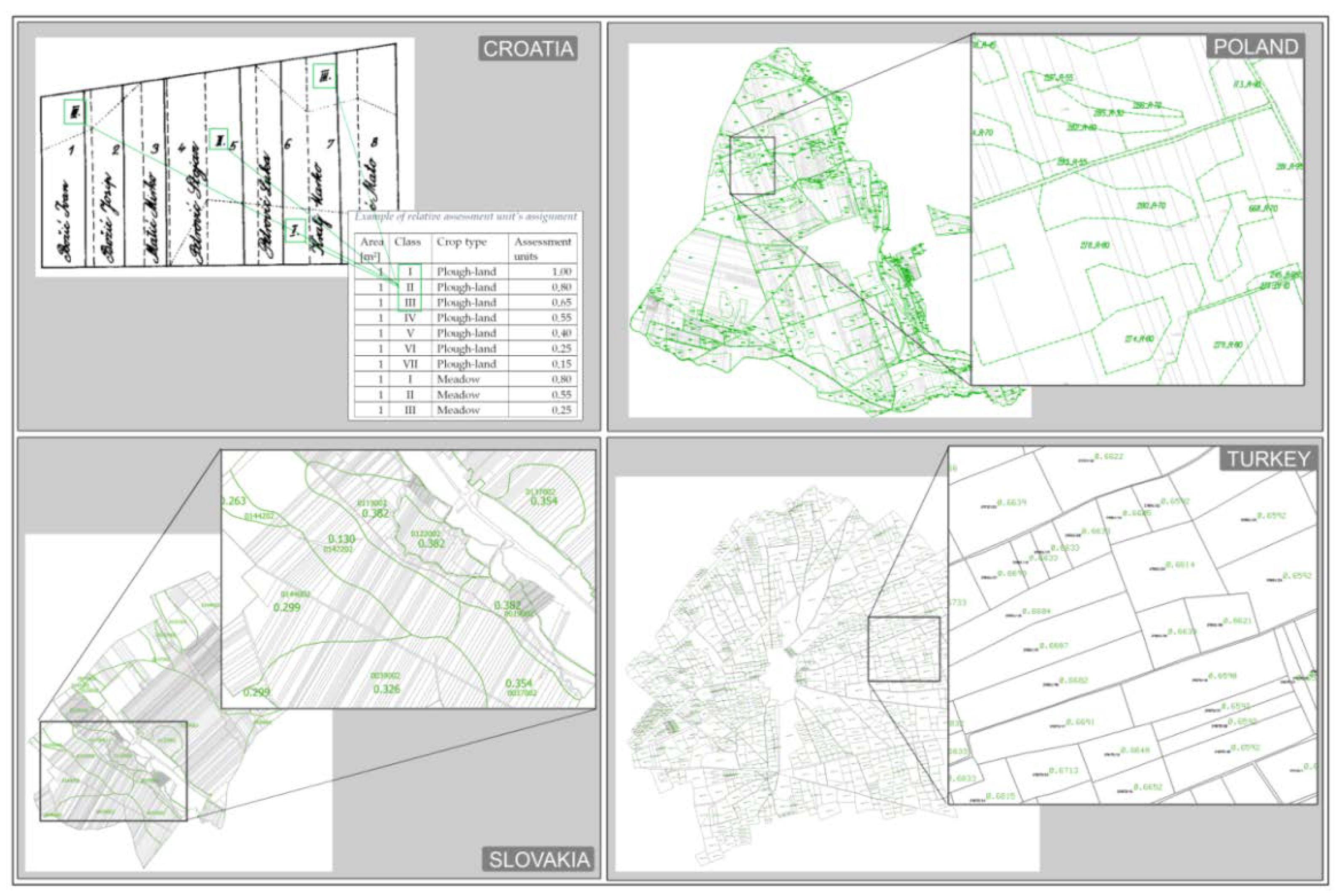
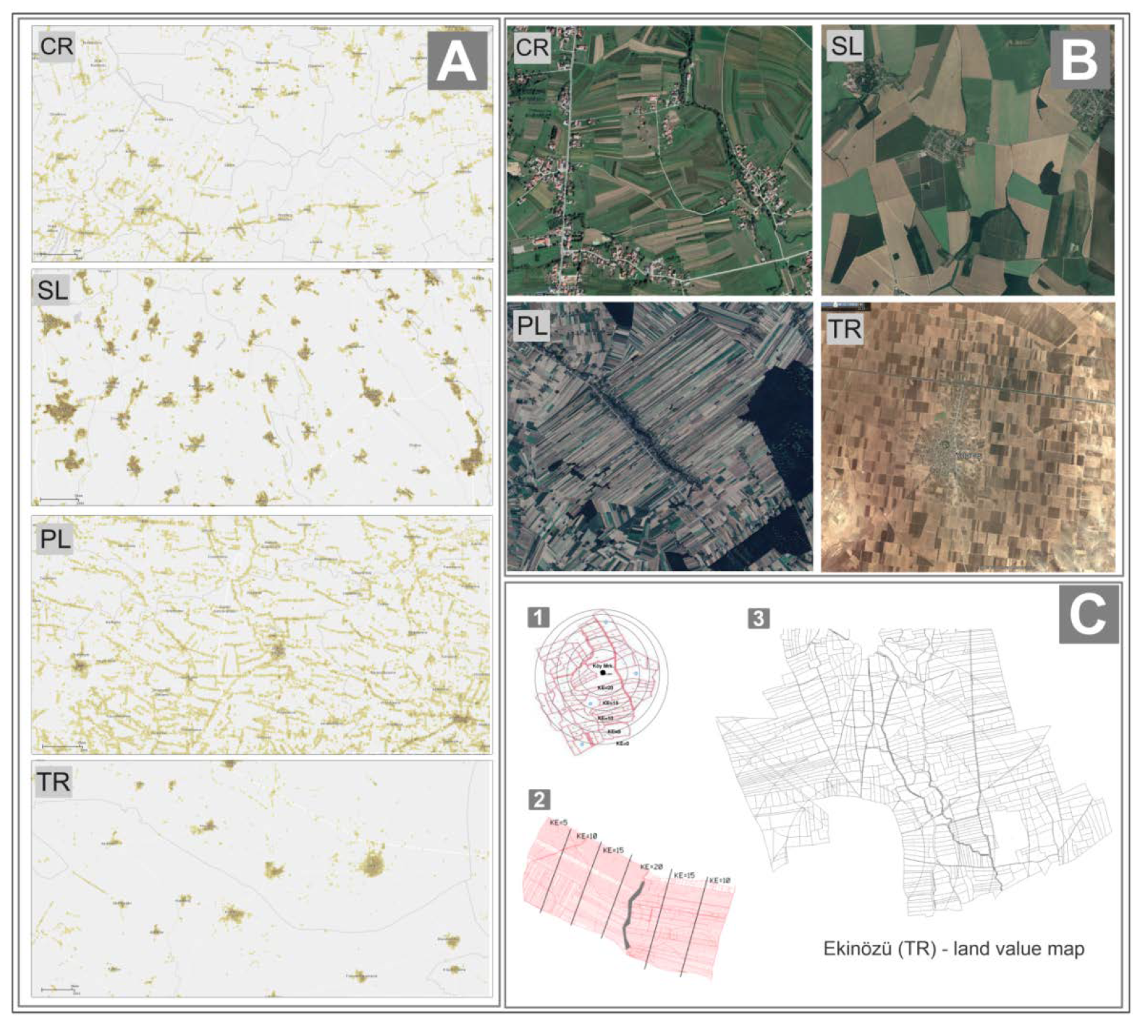
Based on the information gathered, there are two existing approaches to how land is valued. The first is to create a land value map based on estimating the value of land plots—as done in Turkey (
Figure 3). In this approach, the average area value of each parcel is valued based on a number of its attributes, such as soil quality, distance from the village centre, or distance from roads, and the resulting value map in terms of geometry is most often identical to the geometry of a set of parcels. However, the final number of value classes is limited to a few [
14]. A second, more commonly observed approach is the creation of a land value map in a manner that attempts to separate areas of similar agricultural value due to accepted evaluation principles that consider selected land characteristics and the strength of the effect of those characteristics. In this approach, the resulting map of dissimilar value areas is unrelated to the parcel boundaries. This approach in the analysed group of countries is represented by Slovakia, Croatia and Poland. It should be noted that the observed differences in valuation models apply to the study group of four countries and are not unique to LC. A completely different approach is used, for example, in Cyprus, where each plot of land is independently assessed in terms of its market value [
25].
A score-based or quasi-score-based system of value determination is common to the group of the analysed countries. The effect of land valuation for land consolidation projects need not be directly expressed in any currency, and this allows for independence from land price fluctuations that can be associated with several years of consolidation projects. This approach allows land to be allocated as a result of LC with the same equivalent value (usually with a specified tolerance), without the need to reevaluate the land after the project is completed. However, despite the similarities, in this case, one can also point to significant differences between the examined legal systems. In the case of the Croatian model, the determination of land value has the character of relative valuation, in which land of the highest quality receives a value equal to 1 point per 1 m
2, while land of lower classes, identified in the process of dividing the area of the consolidation project into land with different types of use and different quality, receives corresponding lower values of conversion factors. A similar relative valuation approach to the Croatian one for the highest quality land is also present in India, where the highest quality land is given a value of 100 points/ha, and the others correspondingly less [
30].
In Poland, the range of values is always given in points per ha, while the range of values is different for each project. Most often it ranges from a dozen to a hundred points, but there are projects with a value range of several or tens of thousands of points. The large variation in value is especially true for projects that include both agricultural land and land that could potentially be used for investment purposes.
In the case of Turkey, the range of point value (given in points per square meter of land area of a given parcel) is limited by the way it is calculated, where 60% depends on the soil quality index for a given parcel, while 40% is made up of factors related to location (distances from the village centre and from roads) and other factors considered by a given land gradation committee. By evaluating the proximity (rectilinear distance) of the parcels in the project area to the settlement and the road, a location score of up to 25 points and a commission score of up to 15 points are given by stating the reason. Specifically, two factors contribute to the low variation in land values. The first factor is the regulatory standardised range of soil index values; the second is determining the average index value for whole plots which, in Turkish conditions, have a relatively large area of several hectares.
In Slovakia, there are uniform rules for all projects to determine the value of land and crops and uniform procedures for creating a land value map. The value of land comprising agricultural land and areas with other uses is determined according to the land categories present in the project area, which are assigned values in Slovak koruna in accordance with Annex No. 1 of Decree No. 38/2005. When converted to euros, the value of the different categories of agricultural land is between EUR 0.022 and EUR 0.402/m2 for agricultural lands and between EUR 0.017 and EUR 0.302/m2 for other lands. Despite the formal expression of values in currency, these are values deviating from the market values of land, and in practice the values given in the tables should be treated in quasi-point categories, serving only to separate equivalent plots in the process of land consolidation project implementation. However, if the state buys land within LC (only small areas up to 400 m2 for agricultural and up to 2000 m2 for forested ones), it becomes the price in EUR, which is paid to the owner of the land. It should be noted that in the case of Slovakia, no real estate transactions or changes in the area of holdings take place during the consolidation, and the calculated point values cannot be used for direct financial settlements during or after the project.
5.3. Land Attributes Used in Valuation
After the introduction related to the legal regulations, directing the further part of the considerations towards the elaboration of conclusions relevant to the development of universal methods of land valuation, it is necessary to focus first on similarities and differences with regard to factors considered in the land valuation process in the analysed group of countries.
5.3.1. Soil Quality
As a rule (with some exceptions) land consolidation concerns areas used for agricultural purposes and its main task is to improve the functioning and profitability of farms. The fundamental principle of equivalence of land given and received during LC by farm owners, and the fact that the actual relocation mainly concerns parcels with agricultural use, indicates that soil quality and parameters determining its productivity should be a key element affecting its value [
31]. This is confirmed by data from all four countries analysed, but the sources of knowledge about land quality and how these data are used already vary considerably.
The approaches used in neighbouring Poland and Slovakia are the most similar. In both cases, from the late 1950s to early 1970s, comprehensive soil quality studies covering the entire area of these states were completed; these included analysis of the soil profile, granulometric composition, chemical composition and many other factors affecting soil fertility [
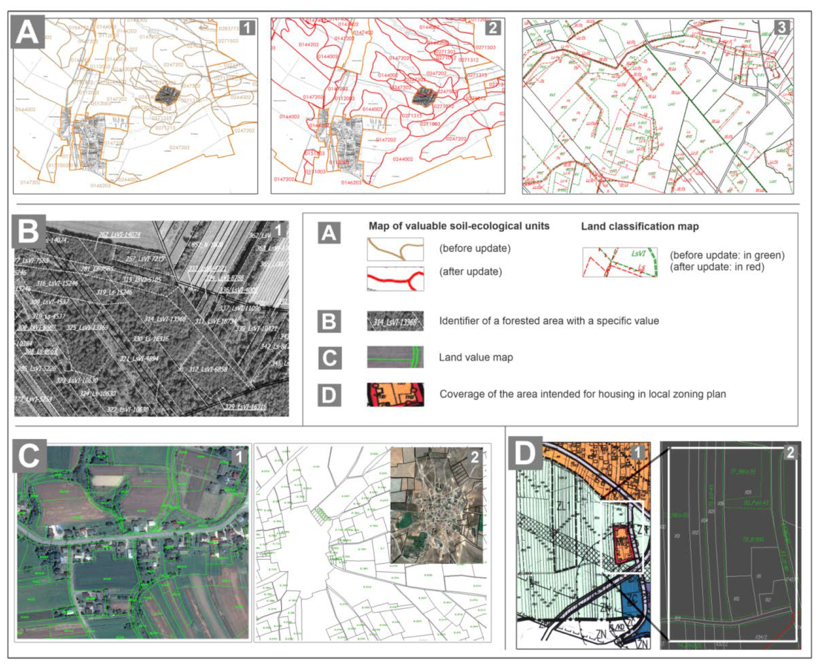
32]. This effort resulted in the development of 1:5000 scale maps along with a series of accompanying reports. In the case of Slovakia, the resulting studies are called “Map of valuable soil-ecological units”, while in the case of Poland they are called “Soil-agricultural maps” and “Land classification maps” (
Figure 4), which are a part of cadastral databases used, e.g., for tax assessment purposes. Prior to the commencement of the project in Poland, and as part of the LC project in Slovakia, these maps are subject to control and necessary update, connected in particular with the update of the ranges of land use of different types and, in justified cases, also including reexamination of soil composition or its physical-chemical properties. In Slovakia, these maps are always adjusted based on a precisely focused planimetry and topography in the process of land consolidation.
Soil quality data in the form of existing soil maps are also used in Croatia to value land in the area of a land consolidation project. However, the Croatia-wide studies are not detailed enough to be used directly in the process of determining land values for the LC, as a result of which up-to-date and detailed soil quality analyses are performed for the project area prior to implementation.
In the case of Turkey, where soil quality data are also crucial for the land value determination process, existing studies conducted for the whole country are not used for this purpose (as in the case of Poland and Slovakia). Land quality surveys, as in the case of Croatia, belong to activities of a preliminary nature and precede the implementation of land consolidation projects. On the one hand, this lengthens the process of the land consolidation project, but on the other hand it makes the soil quality data very up-to-date. In the case of Turkey, the soil index value determined at this stage (representing 60% of the weight of the area value in the valuation process) is calculated using the value assigned for the soil profile determined in the survey, topsoil parameters, slope values and other soil properties.
5.3.2. Distance from Farm Buildings and Village Centre
The distance between buildings and farmland is an important factor in determining the profitability of farming the land and its value from the owner’s point of view [
33]. However, taking this factor into account when developing land value maps for LC is not straightforward. Such an influence in the form of distance zones must be obvious and determinable in an objective manner acceptable to landowners. The size (area) of the village and the type of development of the village appear to be key factors in this regard, with a highly centralised development system facilitating the objective determination and subsequent consideration of distance zones (
Figure 5). The right combination of both factors may determine whether distance zones need to be considered in the LV process, or whether it is advisable not to. Additional factors in this case may also include the layout of the transportation network, the shape of which can significantly affect the actual distances farmers travel [
34]. Distance zones are commonly included in the valuation model used in Turkey, which is associated with the dominant, highly centralised type of development and large areas of villages. Proximity to residential area and road is evaluated and it is clearly mentioned in the law.
In Poland, taking distance zones into account is used very rarely, due to the dispersed spatial layout (location of buildings) or small village areas. Because of that, it is usually either impossible or inexpedient to designate distance zones. In the Croatian area, the distance to the farm-holding building is one of the factors considered in the valuation process. In the case of Slovakia, this factor is not directly indicated in the regulations as relevant in the valuation process. However, at the distribution plan stage, the area of the project is divided into project blocks. Their number and area is determined by taking into account the natural conditions, locality lucrativeness, the distance from the urban area and the future use of individual parts of the territory. There are no explicit rules for their definition; the owners approve the project blocks by 2/3 land majority. Merging is then usually carried out within them and the owners accept shifts inside. The system of project blocks prevents large transfers within the cadastral area that is usually the perimeter of the project.
5.3.3. Topographic Conditions
Topographic conditions are one of the factors obviously affecting the suitability of land for agriculture [
35]. Excessive slope results in increasing water erosion [
36] as well as difficulties in using modern agricultural equipment [
37]. However, the need to consider this parameter in the land estimation process for LC is not obvious. In solutions based on maps of soil quality and its suitability for agricultural purposes (in all surveyed countries), this factor is already indirectly considered at the stage of determining soil types and quality, which in areas with large slopes may have different parameters than in flat areas. In Slovakia, a 7-digit code includes data on soil morphological unit, slope and aspect in 10 categories. In Poland, terrain shape is considered in the process of value mapping, most often during the work of the relevant collegial bodies (Commissions), after providing detailed knowledge of the project area through a field inspection. Areas with very steep slopes, as well as those with slopes and gullies, may be excluded from the estimation process or may be assigned a very low value, so that attaching these types of areas to parcels created during the project does not result in owner protests.
In the case of Croatia, both slope and exposure (direction of inclination) of the ground can be considered. In Turkey, in accordance with the provisions, the Commission does not take into account the topographic conditions of the land. Only indirectly is the slope of the land taken into account when determining the soil index.
5.3.4. Road Access
Convenient road access is a factor in facilitating agricultural operations. Lack of direct access to the field results in the necessity to use crossings through farmlands belonging to other owners, which is associated with technical, legal but also social problems [
38]. However, despite the importance of this phenomenon, this factor is relatively rarely considered in the land valuation process. The reason for this is the strong link between the accessibility of parcels to roads and the layout of boundaries, which ceases to exist during the consolidation project. However, the creation of a new layout of plot boundaries is also related to the modernisation of existing and the creation of new elements of the road network layout, which should provide all plots with direct access to roads [
39]. Nevertheless, in the valuation approach used in Turkey, where the parameters of plots before consolidation are evaluated, this factor is directly included in the valuation process. In the case of the Turkish regulations, road proximity can provide an additional score for parcels, determined by the estimated distances of parcels to dual carriageways, provincial, district and village roads, with the value of the score increasing as the road class increases and as the distance from roads decreases.
The distribution plan in Slovakia must be compiled so that all land after the project is accessible. The project defines the networks of the main field and forest roads, which form the transport axis of the area and connect the neighbouring territories. Those networks are often of regional (especially recreational) importance. They must be passable all year round. Subsequently, secondary field roads are planned to complement the main road networks. Auxiliary roads are usually unpaved and provide access to consolidated land for each owner. Owners comment on the resulting distribution plan, requesting corrections in case of discrepancies.
In the Croatian case, road proximity is also considered to be part of location index. Each land parcel has to have access to the road (by law), either direct or via other land parcels. Nevertheless, if the landowner’s parcel does not have access to the road, he can request it in court.
5.3.5. Spatial Planning
While land quality importance in the LC process is fundamental, it is not the only factor that determines the value of land from the owners’ perspective. Land is not just the primary means of production that enables farms to function; land has also been, is and will continue to be a tangible asset, the price of which may depend on location and the potential for other than agricultural use. It is also a symbol of social standing and reserve capital for emergencies [
40].
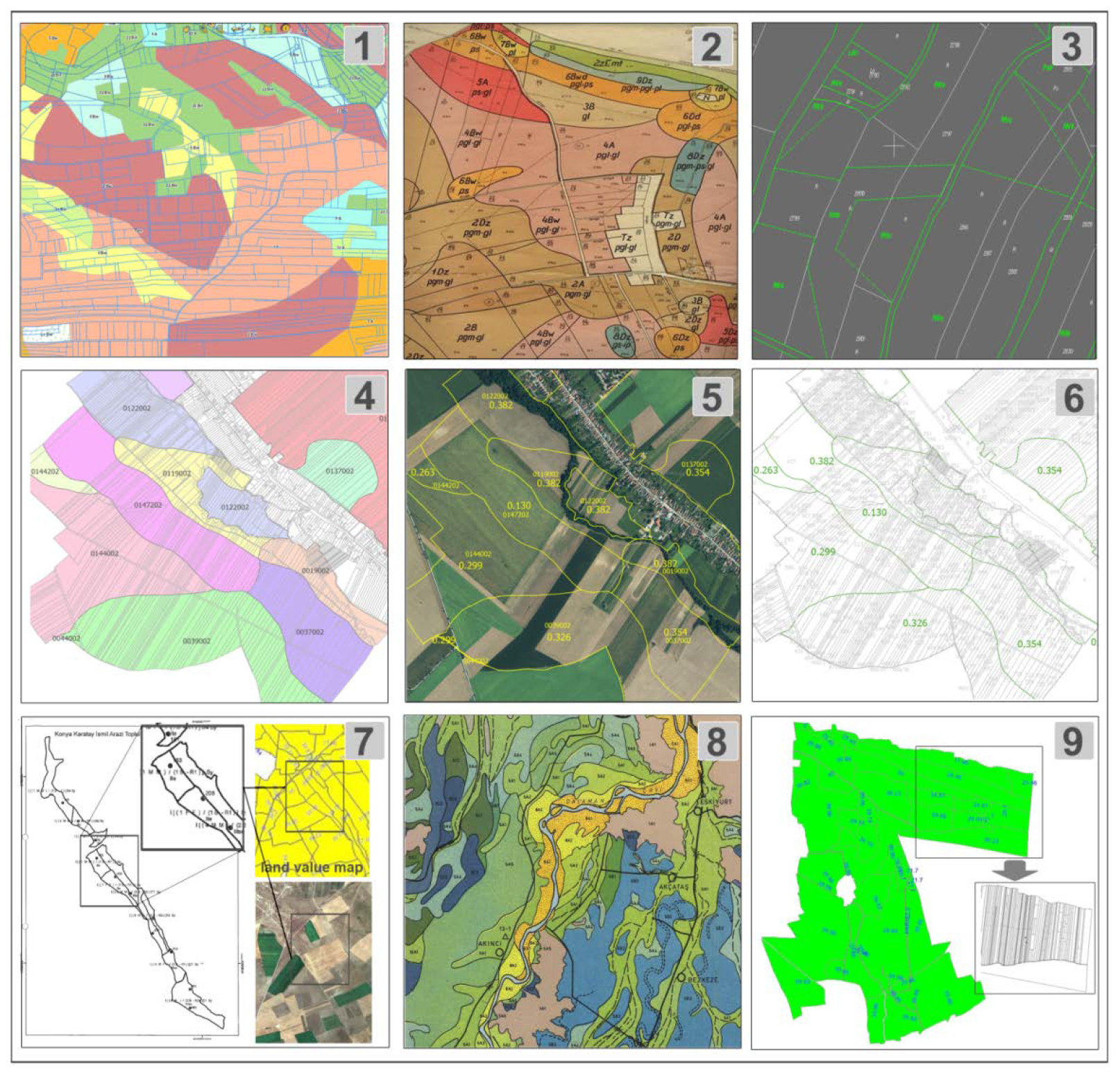
Sometimes, land with a potential use other than agricultural, resulting from the provisions of local development plans or other legal regulations, is included in the consolidation project area. In such cases, these factors may be considered in the process of estimating the value of that land for the LC project. The potential construction nature of the land use causes the value of the said land to increase [
41]. The extent of this increase depends on the level of market prices for a particular type of property in the area of the consolidation project, so it is not possible to relate it to soil quality and other factors affecting the profitability of agricultural production. The effect in such cases can be a very large variation in land values within a small area (
Figure 6), making it difficult to implement a land consolidation project.
In practice, the way in which the problem of land with potential for construction development is solved varies from country to country. In the case of Slovakia, this factor does not affect the value of the land in the LC process, because the areas of separate designation are separate blocks of land delimited within the consolidation project, and land transfers between blocks can be made only with the consent of their owners. At the same time, buildings in the village are highly dense (centralised), which makes it relatively easy to separate typically agricultural areas from areas designated for construction purposes. The LC project also incorporates the prospective sites of new construction on the basis of zoning plans and, as a rule, assigns such localities into separate project blocks for merging. In the case of Poland, the division into blocks of land according to its purpose is not applied. This would be hampered by the highly dispersed layout of development and a zoning system that often allows future development to be located along most streets or—in the absence of a local plan—on a contiguous basis with already developed land. In the case of Poland, the value of agricultural land that can be used for construction purposes may increase by as much as several hundred percent compared to neighbouring land of the same soil quality, but with only agricultural use. The restriction on the movement of land with a different use derives from the provisions of the Act. It includes the requirement that after the consolidation, the value of land designated for construction purposes should not differ by more than 10% from the state before the consolidation. In addition, the permissible range of difference in land value of the entire farm (3%) and its area (20%) between the state before and after consolidation limits changes in land ownership with a significant difference in value.
In the case of Croatia, land use derived from planning documents is not considered in the land estimation process for LC. This is because the land consolidation area usually includes only agricultural land, and if there is occasional land of other types (e.g., buildings), an individual estimate of market value is necessary.
In the case of Turkey, existing land use plans for rural areas are not related to the land consolidation process. At the same time, the area of Turkey is characterised by strongly centralised village development, and built-up areas are excluded from the consolidation project. Having considered the foregoing, the problem of occurrence of agricultural land with different potential uses for Turkish projects does not exist.
5.4. Public Participation
Land consolidation projects change the location of land that has been held by landowners, often for many generations. The level of attachment to land varies not only internationally but also regionally and locally [
42,
43]. Despite these differences, landowner emotions play just as important a role in the land consolidation process as substantive factors [
21,
44]. Taking the landowners’ views into account at the stage of determining land valuation rules is particularly important for two reasons. Firstly, owners should feel that their land has been fairly valued and, secondly, they should accept new locations for their plots, often far from their existing locations. It is difficult to meet these conditions without understanding and accepting the principles of valuation. The simplest way to meet these conditions is through the widest possible participation of the local community in the development of land valuation rules, allowing the impact of key factors as felt by the community to be properly identified and balanced [
16]. However, this study found that participation in the LV procedure by landowners most interested in the project varied surprisingly.
In the case of Poland, the principles of value mapping remain under the complete control of the landowners participating in the land consolidation project. These rules are created with the participation of the Commission (where the participants in the consolidation have a decisive share), and the final proposal is voted on at a meeting of all landowners. Theoretically, each land consolidation project can have completely different land value mapping rules. In practice, the land valuer system is most often based on maps which are a part of the cadastral databases, and which divide land into soil categories and are also used for taxation purposes. The involvement of landowners most often comes down to a determination of the value of particular classes of land, areas designated in the local plan for purposes other than agricultural, requesting corrections to proposed boundaries between areas of different value, and determining how to include other factors that significantly affect the value of land in specific local conditions. In general, the extent of public participation in the LV process in the case of the Polish model of implementation of land consolidation projects should be considered very high.
In the case of Turkey, landowners have some influence on the land valuation process, which can be considered at two levels. The first is the participation of landowner representatives on land grading commissions. However, Turkish regulations leave only a small portion of possible land scoring adjustments available to the commission based on local circumstances, as the vast majority of this value is driven by owner-independent indicators assessing land quality and location-based factors. The land grading commission consists of seven main and three substitute members. Two main and one substitute member to be elected by the owners who own land in the project area are included in the land grading commission.
In the case of Slovakia, the participation of landowners in the process of value mapping is limited in practice to the participation of the applicants’ representatives in the Commission updating the status of land types according to the actual state, while the estimation rules themselves and the range of values are derived from the legislation, and the landowners have no influence on it. However, deviations in area and value stipulated by law must be observed. Eventual non-compliance is possible only with the written consent of the owner [
12].
The lowest level of public participation is observed in Croatia, where the principle of complete absence of landowners’ participation in the process of determining the rules of land valuation and in the process of land value mapping is adopted. On the other hand, landowners may appeal a property valuation decision through the LC process or other decisions they deem unfavourable or unlawful.
5.5. Other Issues
The area covered by a land consolidation project often includes not only land constituting farmland, but also additional components, the value of which should be assessed independently. This is especially true for permanent perennial crops such as vineyards, orchards, hops or fruit bushes. Changing the owners of such crops is not common during LC, but if it occurs, such items must rely on different valuation rules than land. A similar situation applies to buildings which, however, very rarely change ownership during land consolidation projects. In the case of most of the legal arrangements analysed, elements other than land are valued individually by valuers and are in addition to the value of the land itself.
Wooded areas are a slightly different case. Such areas may be included in the area covered by a land consolidation project, as is the case in Poland or Slovakia. The different nature of areas covered by forests in comparison with typically agricultural areas results in the need for different valuation methods, which are most often a combination of land valuation and the value of a forest stand. In the case of Slovakia, the value of forest land is determined as the sum of the base value of the forest land and the value of the distance-based location factor. The value obtained as such is increased by the value of potential forest yield (timber), calculated in accordance with separate regulations. The value is calculated by an authorised forest management expert. In the case of Poland, the value of private forests within the scope of the project is determined based on the results of the Commission (the same one that estimates agricultural land), which includes the species composition of the tree stand, its density and age, and proposes appropriate score values based on that. In cases of diverse forest habitats, this can lead to value maps with a large number of areas of differing value (
Figure 5). In the case of Croatia, forests or other permanent crops are usually excluded from the land consolidation area. If there is a need to include them in the LC project process, their market value should be estimated by an appraiser. In the case of Turkey, forests cannot be included in the area of the consolidation project, which should include only land used for agriculture. Forests are public property and subject to special law provisions. Land consolidation projects in forest areas are not implemented.
5.6. Implications for LV Algorithms Development
As a result of the conducted research, a number of conclusions can be formulated in terms of the possibility of increasing the universality of existing approaches to land valuation for LC purposes, as well as useful knowledge in the process of developing new methods of this type in the future. The development of universal LV methods seems to be more difficult to propose than in the case of the equally frequently addressed land reallocation problem, which can be more easily adapted to the different conditions and specificities of individual countries by modifying the objective function of optimisation models. Not only are the modes of LV stage implementation very large between the countries, but they also change frequently within individual countries, as evidenced by the six-fold change in the mode of land valuation in Turkey from the start of land consolidation projects in that country until 2019 [
14].
Still, the observations made allow us to formulate the thesis that proposing fully universal approaches to the issue of land valuation for LC purposes does not seem possible without dividing it into at least two distinct valuation models and paths of their development, depending on whether the construction of the land value map is based on a set of existing plots (Turkish model), or is based on an assessment of the agricultural suitability of the land without taking into account existing boundaries defining ownership (other countries studied).
The first of these paths is based on valuing individual parcels according to an assumed set of their characteristics. Universal solutions in this area should enable the definition of a set of features considered, and the definition of rules stating the effect of individual features on parcel value, with the definition of a number of alternative, editable functional relationships. The second of these paths should lead to a universal way to separate areas of equivalent value, in which the main source of data is maps of land quality or that determine its suitability for agriculture. When creating a universal model of this type, it is necessary to define an open set of possible spatial data (meteorological conditions, hydrology, landforms and distance zones), the rules of spatial interactions on the land value and the rules of delimitation of areas with a defined value class, together with the determination of the number of these classes.
Multi-criteria methods can be used in cases where it is possible to define a catalogue of features included in land valuation as a result of expert assessment, or where a set of such features is specified in existing regulations. The potential versatility of this group of methods is indicated by the proposal to use them both in determining the plot value index [
14], as well as for the purposes of mapping land values for their agricultural suitability [
12]. In contrast, methods based on linear and nonlinear statistical models created by analysing a limited number of sample properties are better suited to land valuation methods that result in determining the market value of parcels [
19]. It seems appropriate to combine statistical methods with the possibility of spatially explicit analyses, both through the possibility of mass extraction of features relevant to the valuation process and by directly incorporating spatial relationships into the valuation process [
11].
In all the approaches, it is desirable to allow an increased role for expert judgment in determining the valuation principles themselves, the number of features and the strength of their effect. The opinions of landowners [
11]—or bodies in which they have a significant stake—should also be considered expert opinions, since from the local knowledge point of view, landowners have the broadest possible knowledge of the actual quality and suitability of the land. Given the good modelling of expert knowledge, algorithms based on the use of fuzzy logic can be considered particularly effective. For the implementation of classical integration projects, this approach has been proposed by [
15], as well as [
45], and for consolidation in urbanised areas, the suitability of this approach as a key component of creating expert systems to support the LV process is emphasised by [
46]. It seems that the increase in public participation in the LV process as observed in Poland or India [
30] is necessary to ensure adequate public acceptance of the LV results, which are otherwise often subject to criticism [
12]. Nevertheless, from the point of view of valuation automation, the best models were those in which the possible characteristics of the land or parcels to be considered are predetermined, and the landowners only determine the extent of this impact.
Undoubtedly, among all the approaches used in classical land consolidation, land quality is and will remain the key feature in determining land value. However, datasets developed several years ago depicting the spatial variation of land quality do not always reflect its current parameters, as confirmed in the study by [
47]. The purposefulness of updating the existing databases in this field before the start of the project is confirmed by the procedures in force in Poland and Slovakia, while the current situation in the case of Turkey and Croatia—the development of up-to-date studies in the period immediately preceding the land consolidation project—seems to be a better solution.
Automated land valuation methods can only be used in practice during LC in cases where the proposed algorithms will be within the applicable laws of the respective countries. However, the development of such methods can also be considered useful for different applications. The results of such algorithms can provide preliminary, multivariate land value map concepts for public consultation during the initial stages of land consolidation projects. Efficient and parameterised automation of land value mapping methods can also be one of the steps in computer simulation of the land consolidation process projects using land reallocation algorithms [
48], given that land value maps are the basis for the operation of such algorithms [
49]. The creation of land value maps, the content of which is socially acceptable, can also be applied to the determination of compensation when taking over agricultural land (as required by specific investment projects [
50], without the need for individual valuations. This may be especially true when market land prices are difficult to set or are unacceptable to landowners [
40].
6. Summary and Conclusions
The analysed number of four different legal and practical approaches to the implementation of the LV process provides a great advantage, yet at the same time the results obtained indicate that this is a certain limitation of this study. The observed differences in the LV implementation process appeared to be very large even among the group of four countries, and this applies to virtually every aspect of their implementation. It is therefore reasonable to assume that the actual scale of variation for more countries is much higher. This observation has implications for guidance in the development of methods to automate the LV process, which should be parameterised as much as possible in terms of the number of factors considered, how they interact and the strength of their influence. The lack of constancy in LV regulations—which can also be generalised to the entire set of legal regulations for the implementation of LC projects—is another argument supporting the need for parameterisation of algorithms supporting the LV process.
The observed differences question the feasibility of creating a single, universal land valuation model for LC. It seems expedient to develop two pathways of mass appraisal approaches for land valuation: the first one aiming at defining the value of individual plots and the second one boiling down to creating a map of land suitability for agricultural purposes based on a series of data defining the quality of soils, as well as natural and anthropological conditions. After such a separation, the realisation of universal methods that are possible to implement in many different legal conditions seems possible. An attempt to develop such a model or models based on the results of this study should be one of the outcomes of this study and may be the subject of further research.
The observed differences in legislation and methods of land value mapping allow us to conclude that similar problems may also be associated with the universality of algorithms and methods supporting the remaining stages of land consolidation projects. Having considered the foregoing, a broader analysis that includes presenting key differences in the processes of selecting areas for land consolidation projects, their implementation, and the evaluation of their effects under many different legal, social and cultural conditions would be a valuable addition to this research.


