
Ecosystem Services Multifunctionality: An Analytical Framework to Support Sustainable Spatial Planning in Italy


Abstract
:1. Introduction
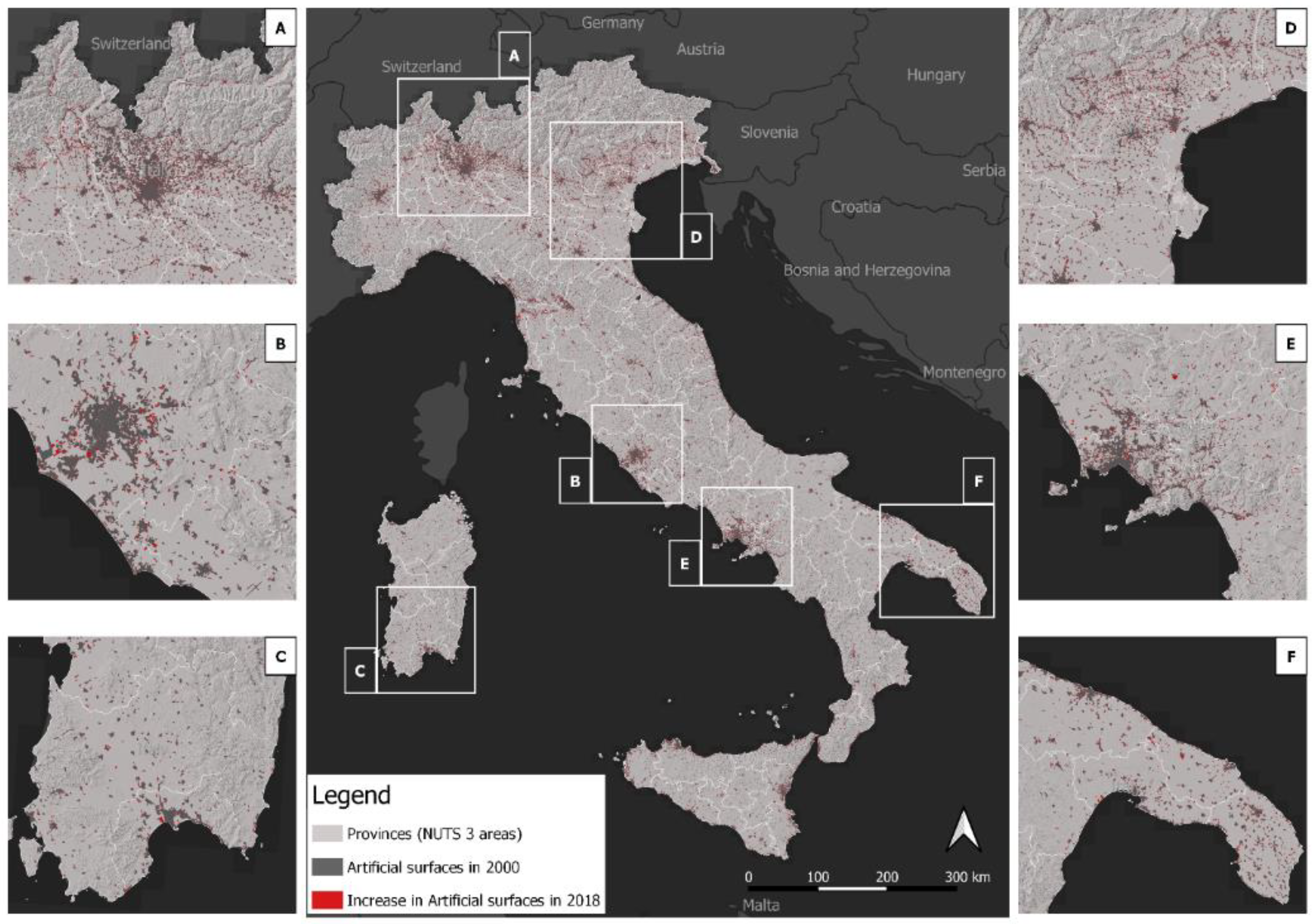
2. Area of Study
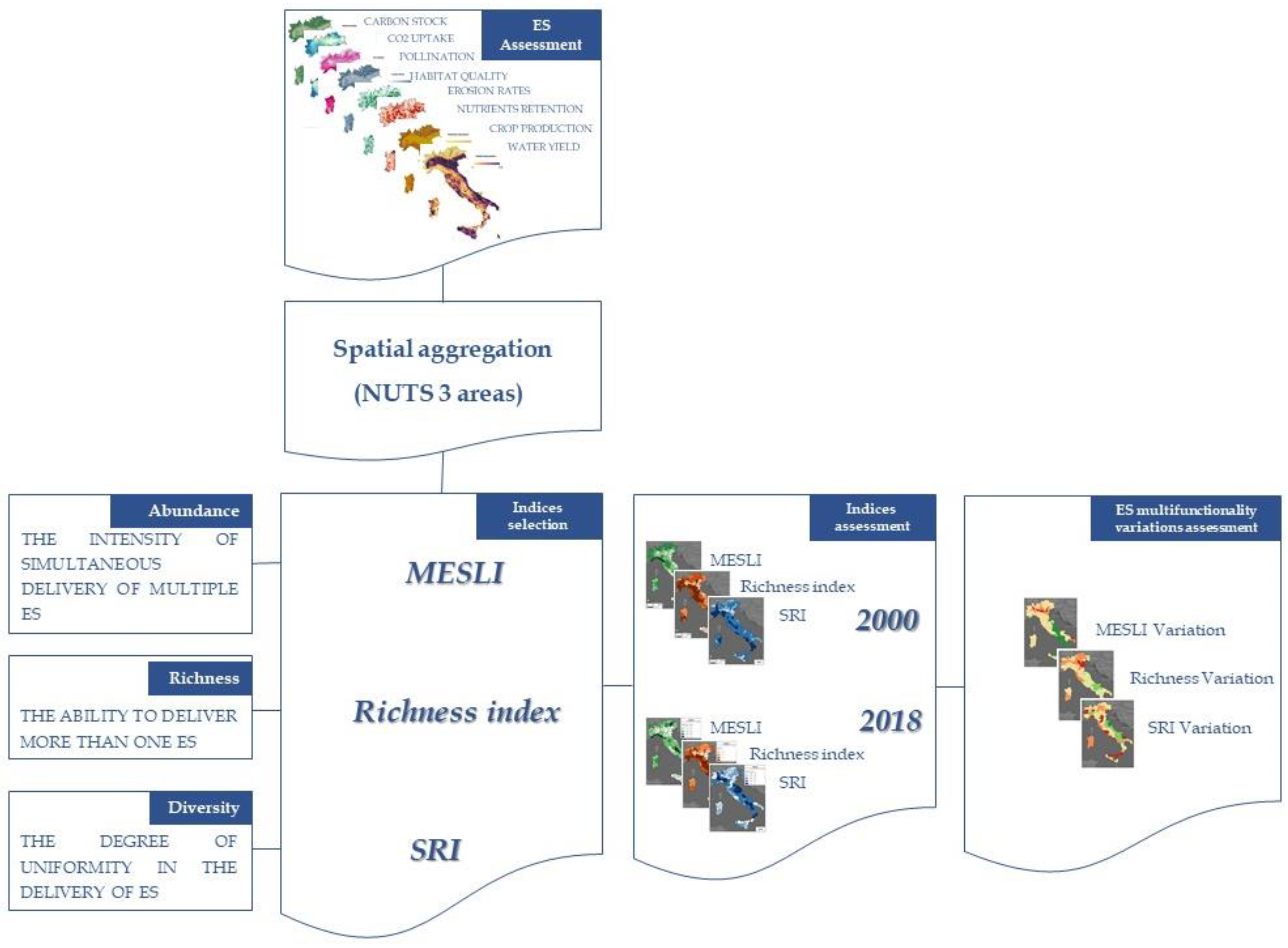
3. Methodology
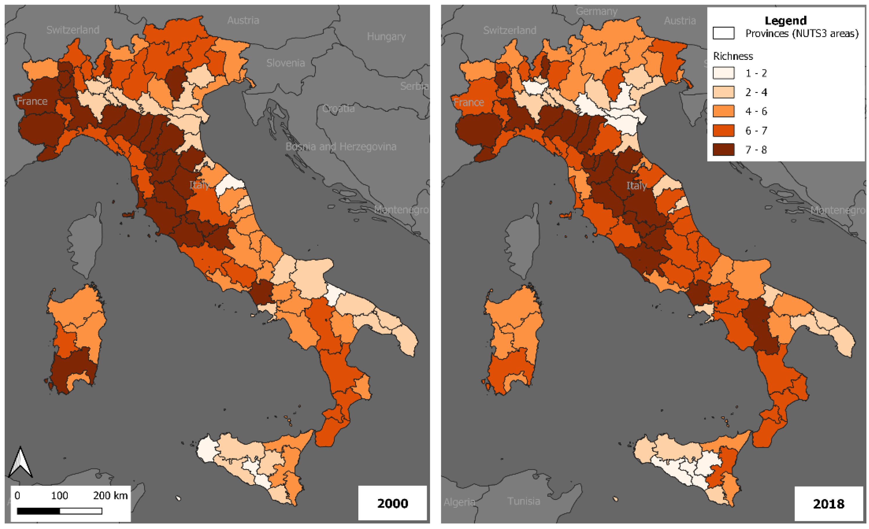
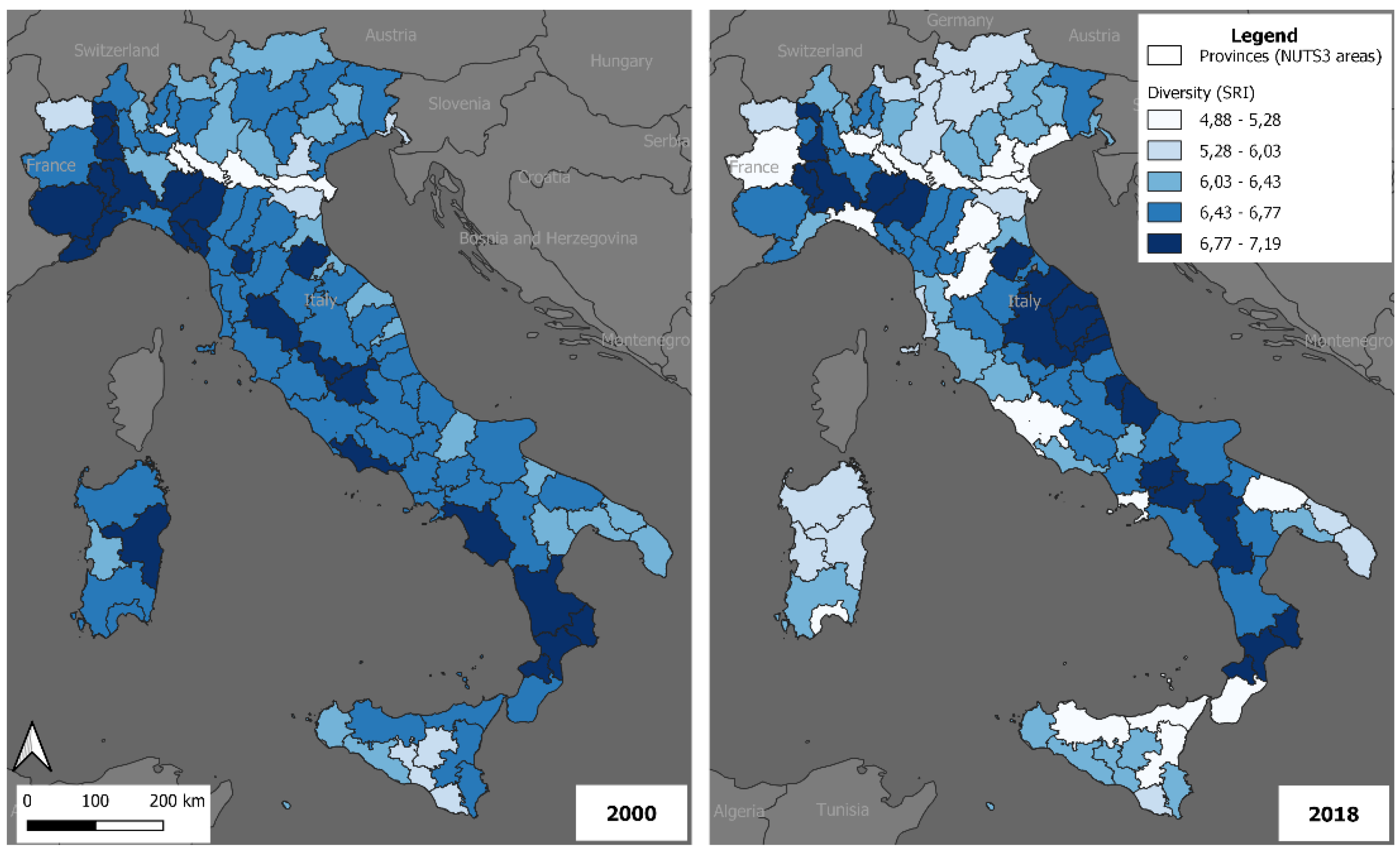
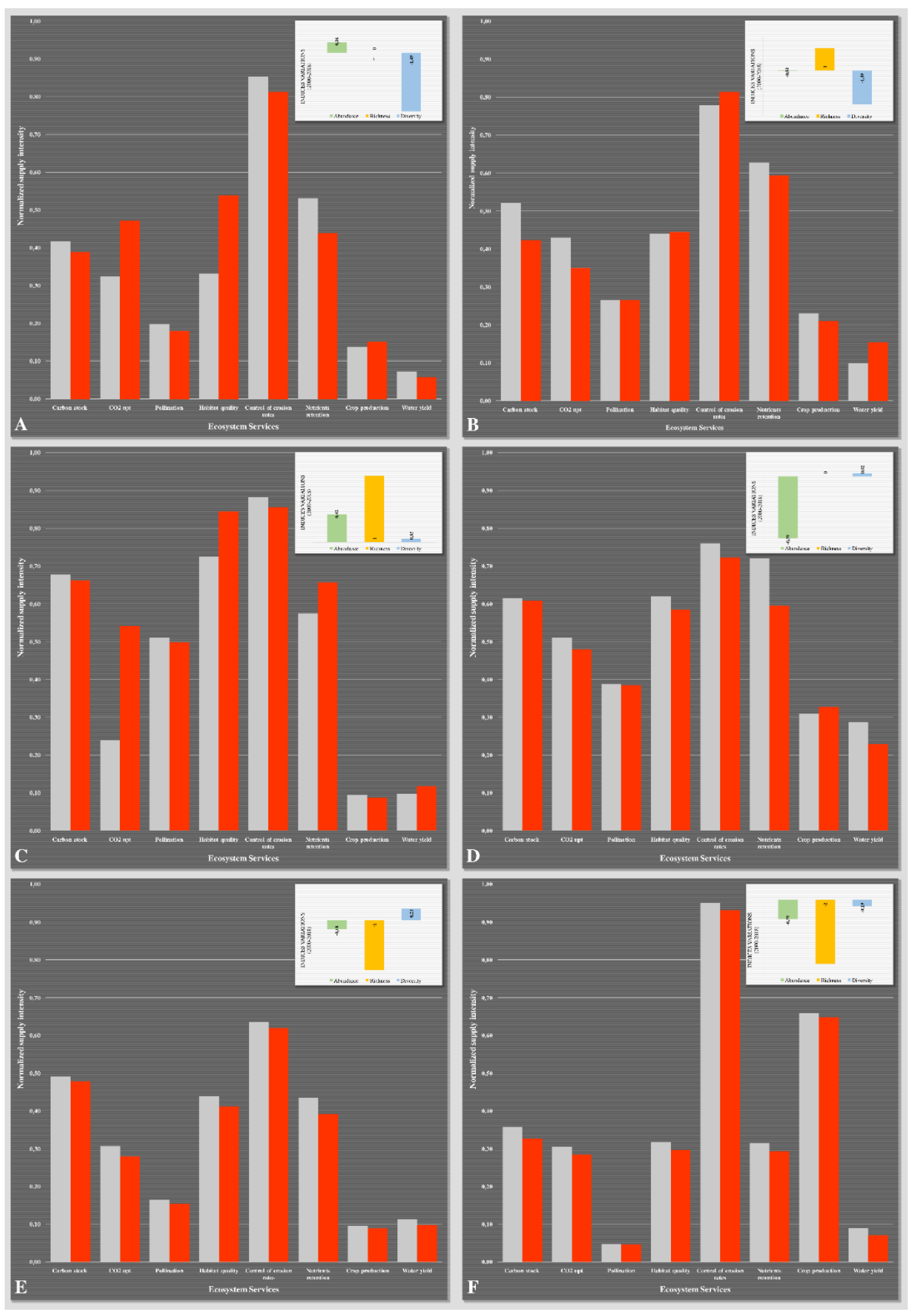
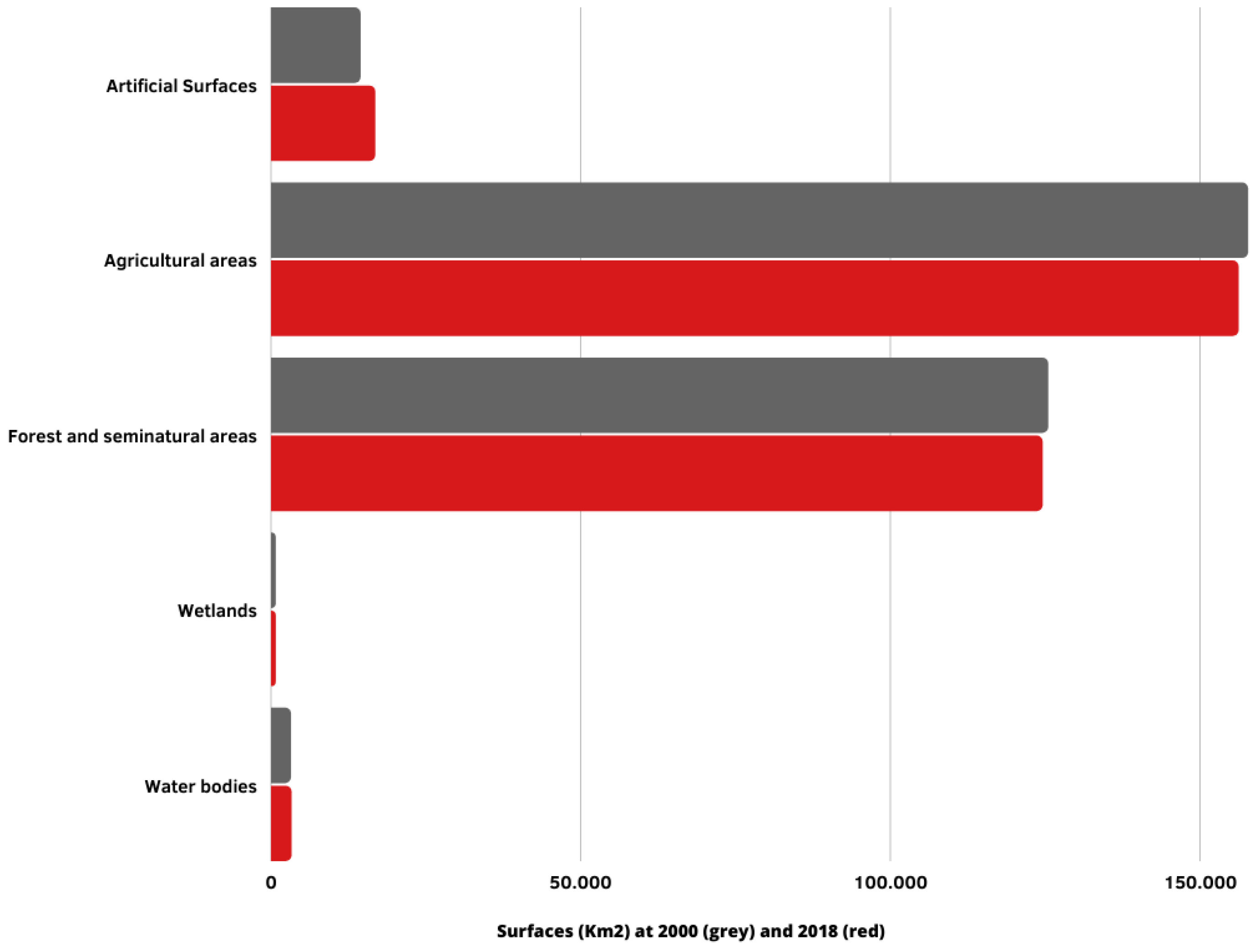
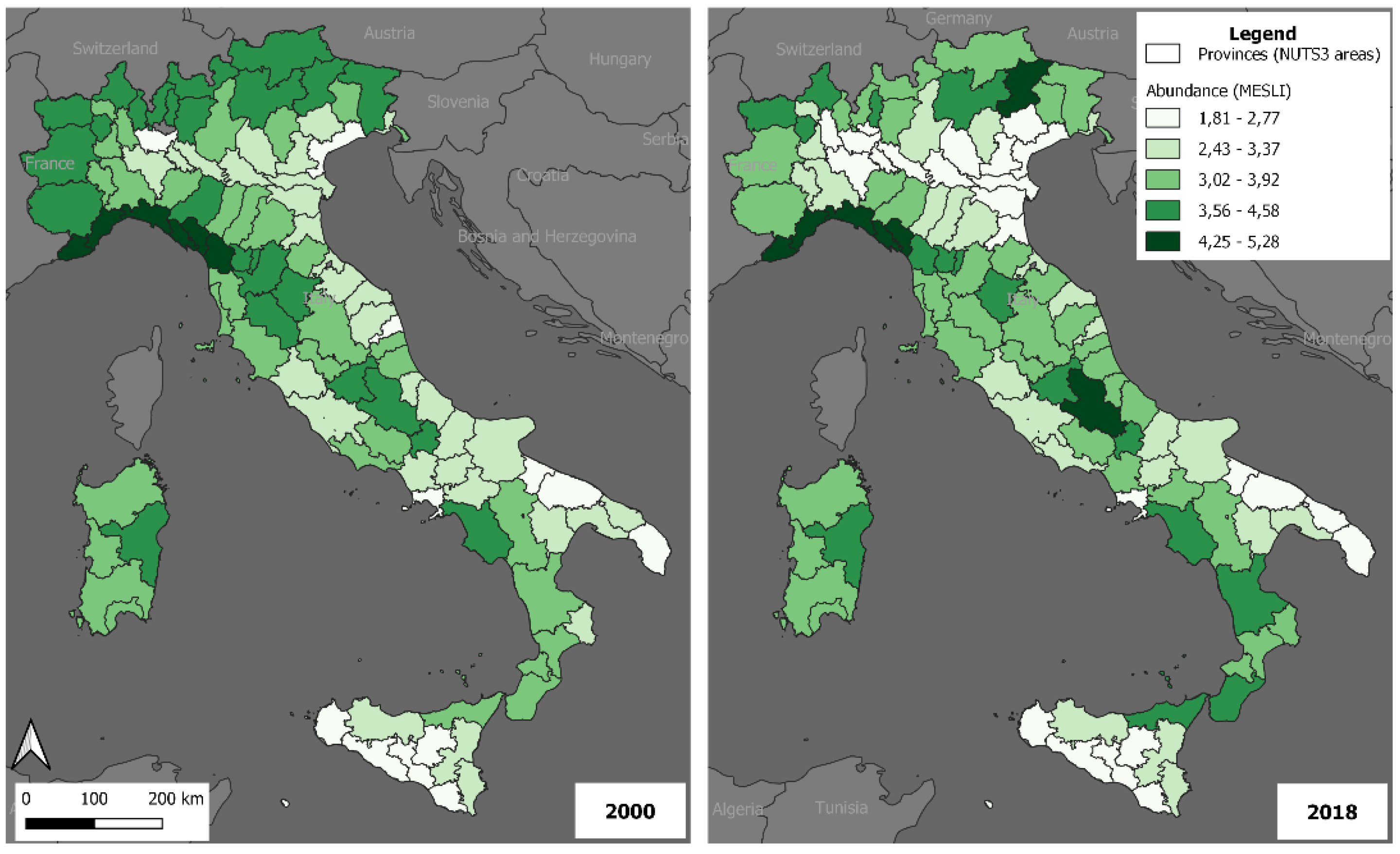
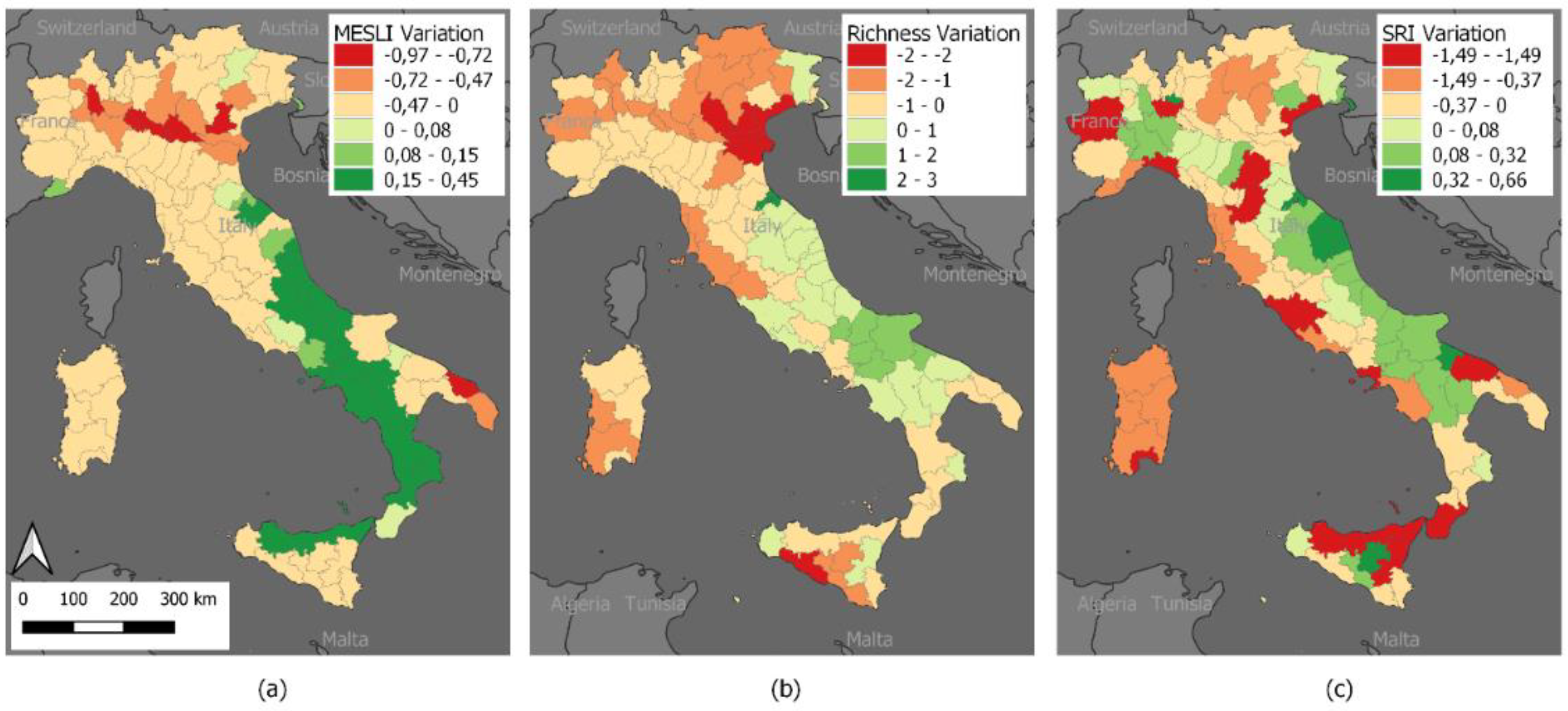
4. Results
5. Conclusions
Author Contributions
Funding
Institutional Review Board Statement
Informed Consent Statement
Data Availability Statement
Conflicts of Interest
References
- Pilogallo, A.; Scorza, F. Regulation and maintenance ecosystem services (ReMES): A spatial assessment in the Basilicata Region (Southern Italy). In Proceedings of the International Conference on Computational Science and Its Applications—ICCSA 2021, Cagliari, Italy, 13–16 September 2021; Volume 12955, pp. 703–716. [Google Scholar]
- Nelson, E.; Sander, H.; Hawthorne, P.; Conte, M.; Ennaanay, D.; Wolny, S.; Manson, S.; Polasky, S. Projecting global land-use change and its effect on ecosystem service provision and biodiversity with simple models. PLoS ONE 2010, 5, e14327. [Google Scholar] [CrossRef] [PubMed] [Green Version]
- Pilogallo, A.; Scorza, F. Mapping regulation ecosystem services (ReMES) specialization in Italy. J. Urban Plan. Dev. 2022, 148, 04021072. [Google Scholar] [CrossRef]
- Lai, S.; Leone, F.; Zoppi, C. Implementing green infrastructures beyond protected areas. Sustainability 2018, 10, 3544. [Google Scholar] [CrossRef] [Green Version]
- Lai, S.; Leone, F. Bridging biodiversity conservation objectives with landscape planning through green infrastructures: A case study from Sardinia, Italy. In Proceedings of the International Conference on Computational Science and Its Applications—ICCSA 2017, Trieste, Italy, 3–6 July 2017; Volume 10409, pp. 456–472. [Google Scholar]
- Primmer, E.; Furman, E. Operationalising ecosystem service approaches for governance: Do measuring, mapping and valuing integrate sector-specific knowledge systems? Ecosyst. Serv. 2012, 1, 85–92. [Google Scholar] [CrossRef] [Green Version]
- Artmann, M. Institutional efficiency of urban soil sealing management—From raising awareness to better implementation of sustainable development in Germany. Landsc. Urban Plan. 2014, 131, 83–95. [Google Scholar] [CrossRef]
- Hansen, R.; Frantzeskaki, N.; McPhearson, T.; Rall, E.; Kabisch, N.; Kaczorowska, A.; Kain, J.H.; Artmann, M.; Pauleit, S. The uptake of the ecosystem services concept in planning discourses of European and American cities. Ecosyst. Serv. 2015, 12, 228–246. [Google Scholar] [CrossRef] [Green Version]
- Dendoncker, N.; Keune, H.; Jacobs, S.; Gómez-Baggethun, E. Inclusive ecosystem services valuation. In Ecosystem Services: Global Issues, Local Practices; Elsevier: Amsterdam, The Netherlands, 2013; pp. 3–12. ISBN 9780124199644. [Google Scholar]
- Las Casas, G.; Scorza, F. Sustainable planning: A methodological toolkit. In Proceedings of the International Conference on Computational Science and Its Applications—ICCSA 2016, Beijing, China, 4–7 July 2016; Volume 9786, pp. 627–635, ISBN 978-3-319-42085-1. [Google Scholar]
- Gómez-Baggethun, E.; Barton, D.N. Classifying and valuing ecosystem services for urban planning. Ecol. Econ. 2013, 86, 235–245. [Google Scholar] [CrossRef]
- Selman, P. Planning for landscape multifunctionality. Sustain. Sci. Pract. Policy 2009, 5, 45–52. [Google Scholar] [CrossRef]
- De Groot, R. Function-analysis and valuation as a tool to assess land use conflicts in planning for sustainable, multi-functional landscapes. Landsc. Urban Plan. 2006, 75, 175–186. [Google Scholar] [CrossRef]
- Spyra, M.; La Rosa, D.; Zasada, I.; Sylla, M.; Shkaruba, A. Governance of ecosystem services trade-offs in peri-urban landscapes. Land Use Policy 2020, 95, 104617. [Google Scholar] [CrossRef]
- Haase, D.; Schwarz, N.; Strohbach, M.; Kroll, F.; Seppelt, R. Synergies, trade-offs, and losses of ecosystem services in urban regions: An integrated multiscale framework applied to the leipzig-halle region, Germany. Ecol. Soc. 2012, 17, 22. [Google Scholar] [CrossRef]
- Galler, C.; von Haaren, C.; Albert, C. Optimizing environmental measures for landscape multifunctionality: Effectiveness, efficiency and recommendations for agri-environmental programs. J. Environ. Manag. 2015, 151, 243–257. [Google Scholar] [CrossRef] [PubMed]
- Galler, C.; Albert, C.; von Haaren, C. From regional environmental planning to implementation: Paths and challenges of integrating ecosystem services. Ecosyst. Serv. 2016, 18, 118–129. [Google Scholar] [CrossRef]
- Hashimoto, S.; Sato, Y.; Morimoto, H. Public–private collaboration in allotment garden operation has the potential to provide ecosystem services to urban dwellers more efficiently. Paddy Water Environ. 2019, 17, 391–401. [Google Scholar] [CrossRef]
- Baró, F.; Gómez-Baggethun, E.; Haase, D. Ecosystem service bundles along the urban-rural gradient: Insights for landscape planning and management. Ecosyst. Serv. 2017, 24, 147–159. [Google Scholar] [CrossRef] [Green Version]
- Peña, L.; Onaindia, M.; de Manuel, B.F.; Ametzaga-Arregi, I.; Casado-Arzuaga, I. Analysing the synergies and trade-offs between ecosystem services to reorient land use planning in Metropolitan Bilbao (Northern Spain). Sustainability 2018, 10, 4376. [Google Scholar] [CrossRef] [Green Version]
- Scorza, F.; Pilogallo, A.; Saganeiti, L.; Murgante, B.; Pontrandolfi, P. Comparing the territorial performances of renewable energy sources’ plants with an integrated ecosystem services loss assessment: A case study from the Basilicata region (Italy). Sustain. Cities Soc. 2020, 56, 102082. [Google Scholar] [CrossRef]
- Saganeiti, L.; Favale, A.; Pilogallo, A.; Scorza, F.; Murgante, B. Assessing urban fragmentation at regional scale using sprinkling indexes. Sustainability 2018, 10, 3274. [Google Scholar] [CrossRef] [Green Version]
- Rodríguez-Loinaz, G.; Alday, J.G.; Onaindia, M. Multiple ecosystem services landscape index: A tool for multifunctional landscapes conservation. J. Environ. Manag. 2015, 147, 152–163. [Google Scholar] [CrossRef]
- Queiroz, C.; Meacham, M.; Richter, K.; Norström, A.V.; Andersson, E.; Norberg, J.; Peterson, G. Mapping bundles of ecosystem services reveals distinct types of multifunctionality within a Swedish landscape. Ambio 2015, 44, 89–101. [Google Scholar] [CrossRef] [Green Version]
- Mastrangelo, M.E.; Weyland, F.; Villarino, S.H.; Barral, M.P.; Nahuelhual, L.; Laterra, P.; Villarino, S.H.; Barral, Á.M.P.; Laterra, Á.P.; Nahuelhual, L. Concepts and methods for landscape multifunctionality and a unifying framework based on ecosystem services. Landsc. Ecol. 2014, 29, 345–358. [Google Scholar] [CrossRef]
- Jiang, W. Mapping ecosystem service value in Germany. Int. J. Sustain. Dev. World Ecol. 2018, 25, 518–534. [Google Scholar] [CrossRef]
- Pilogallo, A.; Scorza, F.; Murgante, B. An Ecosystem Services-Based Territorial Ranking for Italian Provinces. In Proceedings of the International Conference on Computational Science and Its Applications—ICCSA 2021, Cagliari, Italy, 13–16 September 2021; Volume 12955, pp. 692–702. [Google Scholar]
- Staiano, L.; Camba Sans, G.H.; Baldassini, P.; Gallego, F.; Texeira, M.A.; Paruelo, J.M. Putting the ecosystem services idea at work: Applications on impact assessment and territorial planning. Environ. Dev. 2021, 38, 100570. [Google Scholar] [CrossRef]
- Plieninger, T.; Dijks, S.; Oteros-Rozas, E.; Bieling, C. Assessing, mapping, and quantifying cultural ecosystem services at community level. Land Use Policy 2013, 33, 118–129. [Google Scholar] [CrossRef] [Green Version]
- Karjalainen, T.P.; Marttunen, M.; Sarkki, S.; Rytkönen, A.M. Integrating ecosystem services into environmental impact assessment: An analytic-deliberative approach. Environ. Impact Assess. Rev. 2013, 40, 54–64. [Google Scholar] [CrossRef]
- Meerow, S.; Newell, J.P. Spatial planning for multifunctional green infrastructure: Growing resilience in Detroit. Landsc. Urban Plan. 2017, 159, 62–75. [Google Scholar] [CrossRef]
- Hölting, L.; Jacobs, S.; Felipe-Lucia, M.R.; Maes, J.; Norström, A.V.; Plieninger, T.; Cord, A.F. Measuring ecosystem multifunctionality across scales. Environ. Res. Lett. 2019, 14, 124083. [Google Scholar] [CrossRef] [Green Version]
- Hasan, S.; Shi, W.; Zhu, X. Impact of land use land cover changes on ecosystem service value—A case study of Guangdong, Hong Kong, and Macao in South China. PLoS ONE 2020, 15, e0231259. [Google Scholar] [CrossRef] [Green Version]
- Fiorini, L.; Marucci, A.; Zullo, F.; Romano, B. Indicator engineering for land take control and settlement sustainability. WIT Trans. Ecol. Environ. 2018, 217, 437–446. [Google Scholar]
- Romano, B.; Fiorini, L.; Zullo, F.; Marucci, A. Urban growth control DSS techniques for de-sprinkling process in Italy. Sustainability 2017, 9, 1852. [Google Scholar] [CrossRef] [Green Version]
- Manganelli, B.; Murgante, B.; Saganeiti, L. The social cost of urban sprinkling. Sustainability 2020, 12, 2236. [Google Scholar] [CrossRef] [Green Version]
- Hassan, S.T.; Baloch, M.A.; Mahmood, N.; Zhang, J. Linking economic growth and ecological footprint through human capital and biocapacity. Sustain. Cities Soc. 2019, 47, 101516. [Google Scholar]
- La Rosa, D.; Pappalardo, V. Planning for spatial equity—A performance based approach for sustainable urban drainage systems. Sustain. Cities Soc. 2020, 53, 101885. [Google Scholar] [CrossRef]
- Turkelboom, F.; Leone, M.; Jacobs, S.; Kelemen, E.; García-Llorente, M.; Baró, F.; Termansen, M.; Barton, D.N.; Berry, P.; Stange, E.; et al. When we cannot have it all: Ecosystem services trade-offs in the context of spatial planning. Ecosyst. Serv. 2018, 29, 566–578. [Google Scholar] [CrossRef]
- Murgante, B.; Balletto, G.; Borruso, G.; Saganeiti, L.; Scorza, F.; Pilogallo, A.; Dettori, M.; Castiglia, P. Health hazard scenarios in Italy after the COVID-19 outbreak: A methodological proposal. Sci. Reg. 2021, 20, 327–354. [Google Scholar]
- Murgante, B.; Borruso, G.; Balletto, G.; Castiglia, P.; Dettori, M. Why Italy first? Health, geographical and planning aspects of the COVID-19 outbreak. Sustainability 2020, 12, 5064. [Google Scholar] [CrossRef]
- Zullo, F.; Montaldi, C.; Romano, B.; Zullo, F.; Montaldi, C.; Romano, B. Indicators engineering for land uptake and agricultural loss. A study in European countries. Curr. Urban Stud. 2021, 9, 813–830. [Google Scholar] [CrossRef]
- Comitato per il Capitale Naturale. Quarto Rapporto Sullo Stato del Capitale Naturale in Italia; Comitato per il Capitale Naturale: Roma, Italy, 2021.
- Fiorini, L.; Zullo, F.; Marucci, A.; Di Dato, C.; Romano, B. Planning tool mosaic (Ptm): A platform for Italy, a country without a strategic framework. Land 2021, 10, 279. [Google Scholar] [CrossRef]
- Romano, B.; Zullo, F.; Fiorini, L.; Ciabò, S.; Marucci, A. Sprinkling: An approach to describe urbanization dynamics in Italy. Sustainability 2017, 9, 97. [Google Scholar] [CrossRef] [Green Version]
- Saganeiti, L.; Mustafà, A.; Teller, J.; Murgante, B. Modeling urban sprinkling with cellular automata. Sustain. Cities Soc. 2020, 65, 102586. [Google Scholar] [CrossRef]
- Science for Environment Policy. Future Brief: No Net Land Take by 2050? European Commission DG Environment: Bristol, UK, 2016. [Google Scholar]
- Romano, B.; Fiorini, L.; Marucci, A. Italy without urban “sprinkling”. A uchronia for a country that needs a retrofit of its urban and landscape planning. Sustainability 2019, 11, 3469. [Google Scholar] [CrossRef] [Green Version]
- Romano, B.; Zullo, F. The urban transformation of Italy’s Adriatic coastal strip: Fifty years of unsustainability. Land Use Policy 2014, 38, 26–36. [Google Scholar] [CrossRef]
- Romano, B.; Zullo, F.; Marucci, A.; Fiorini, L. Vintage urban planning in Italy: Land management with the tools of the mid-twentieth century. Sustainability 2018, 10, 4125. [Google Scholar] [CrossRef] [Green Version]
- Caldarice, O.; Cozzolino, S. Institutional contradictions and attempts at innovation. Evidence from the Italian urban facility planning. Eur. Plan. Stud. 2019, 27, 68–85. [Google Scholar] [CrossRef]
- Ponzini, D. Introduction: Crisis and renewal of contemporary urban planning. Eur. Plan. Stud. 2016, 24, 1237–1245. [Google Scholar] [CrossRef] [Green Version]
- Palermo, P.C.; Ponzini, D. At the crossroads between urban planning and urban design: Critical lessons from three Italian case studies. Plan. Theory Pract. 2012, 13, 445–460. [Google Scholar] [CrossRef]
- Scorza, F.; Saganeiti, L.; Pilogallo, A.; Murgante, B. Ghost planning: The inefficiency of energy sector policies in a low population density region. In Archivio di Studi Urbani e Regionali; Torrossa: Fiesole, Italy, 2020; pp. 34–55. [Google Scholar]
- The Roadmap to a Resource Efficient Europe. Available online: https://ec.europa.eu/environment/resource_efficiency/about/roadmap/index_en.htm (accessed on 12 January 2022).
- Tarabon, S.; Calvet, C.; Delbar, V.; Dutoit, T.; Isselin-Nondedeu, F. Integrating a landscape connectivity approach into mitigation hierarchy planning by anticipating urban dynamics. Landsc. Urban Plan. 2020, 202, 103871. [Google Scholar] [CrossRef]
- Muzzillo, V.; Pilogallo, A.; Saganeiti, L.; Santarsiero, V.; Scorza, F.; Murgante, B. Impact of renewable energy installations on habitat quality. In Proceedings of the International Conference on Computational Science and Its Applications—ICCSA 2020, Cagliari, Italy, 1–4 July 2020; Volume 12253, pp. 636–644. [Google Scholar]
- Pilogallo, A.; Saganeiti, L.; Scorza, F.; Las Casas, G. Tourism attractiveness: Main components for a spacial appraisal of major destinations according with ecosystem services approach. In Proceedings of the International Conference on Computational Science and Its Applications—ICCSA 2018, Melbourne, VIC, Australia, 2–5 July 2018; pp. 712–724. [Google Scholar]
- Haines-Young, R.; Potschin, M. Common International Classification of Ecosystem Services (CICES) V5.1 Guidance on the Application of the Revised Structure; Fabis Consulting Ltd.: Nottingham, UK, 2018. [Google Scholar]
- Mouillot, D.; Villéger, S.; Scherer-Lorenzen, M.; Mason, N.W.H. Functional structure of biological communities predicts ecosystem multifunctionality. PLoS ONE 2011, 6, e17476. [Google Scholar] [CrossRef] [Green Version]
- Zhang, S.; Muñoz Ramírez, F. Assessing and mapping ecosystem services to support urban green infrastructure: The case of Barcelona, Spain. Cities 2019, 92, 59–70. [Google Scholar] [CrossRef]
- Allan, E.; Manning, P.; Alt, F.; Binkenstein, J.; Blaser, S.; Blüthgen, N.; Böhm, S.; Grassein, F.; Hölzel, N.; Klaus, V.H.; et al. Land use intensification alters ecosystem multifunctionality via loss of biodiversity and changes to functional composition. Ecol. Lett. 2015, 18, 834–843. [Google Scholar] [CrossRef]
- Stürck, J.; Verburg, P.H. Multifunctionality at what scale? A landscape multifunctionality assessment for the European Union under conditions of land use change. Landsc. Ecol. 2017, 32, 481–500. [Google Scholar] [CrossRef] [Green Version]
- Shen, J.; Li, S.; Liang, Z.; Liu, L.; Li, D.; Wu, S. Exploring the heterogeneity and nonlinearity of trade-offs and synergies among ecosystem services bundles in the Beijing-Tianjin-Hebei urban agglomeration. Ecosyst. Serv. 2020, 43, 101103. [Google Scholar] [CrossRef]
- Manning, P.; Van Der Plas, F.; Soliveres, S.; Allan, E.; Maestre, F.T.; Mace, G.; Whittingham, M.J.; Fischer, M. Redefining ecosystem multifunctionality. Nat. Ecol. Evol. 2018, 2, 427–436. [Google Scholar] [CrossRef] [PubMed]
- Manea, E.; Di Carlo, D.; Depellegrin, D.; Agardy, T.; Gissi, E. Multidimensional assessment of supporting ecosystem services for marine spatial planning of the Adriatic Sea. Ecol. Indic. 2019, 101, 821–837. [Google Scholar] [CrossRef]
- Simpson, E.H. Measurement of diversity. Nature 1949, 688, 1949. [Google Scholar] [CrossRef]
- Raudsepp-Hearne, C.; Peterson, G.D.; Bennett, E.M. Ecosystem service bundles for analyzing tradeoffs in diverse landscapes. Proc. Natl. Acad. Sci. USA 2010, 107, 5242–5247. [Google Scholar] [CrossRef] [Green Version]
- McPhearson, T.; Andersson, E.; Elmqvist, T.; Frantzeskaki, N. Resilience of and through urban ecosystem services. Ecosyst. Serv. 2015, 12, 152–156. [Google Scholar] [CrossRef]


| Class * | Indicators | Methods | Unit |
|---|---|---|---|
| Regulation of chemical composition of atmosphere | Carbon stock | InVEST | Tons/Ha |
| CO2 Uptake | Eq. by Clark | g/m2/year | |
| Pollination | Pollination Abundance | InVEST | Index ** |
| Maintaining nursery populations and habitats | Habitat Quality | InVEST | Index ** |
| Control of erosion rates | Erosion Rates | InVEST | Tons/Ha |
| Regulation of the chemical condition of freshwaters | Effective nutrients retention | InVEST | Index ** |
| Cultivated terrestrial plants grown for nutritional purposes | Crop production | InVEST | q/Ha |
| Ground (and subsurface) water for drinking | Water Yield | Eq. by Budyko | mm/year/Ha |
Publisher’s Note: MDPI stays neutral with regard to jurisdictional claims in published maps and institutional affiliations. |
© 2022 by the authors. Licensee MDPI, Basel, Switzerland. This article is an open access article distributed under the terms and conditions of the Creative Commons Attribution (CC BY) license (https://creativecommons.org/licenses/by/4.0/).
Share and Cite
Pilogallo, A.; Scorza, F. Ecosystem Services Multifunctionality: An Analytical Framework to Support Sustainable Spatial Planning in Italy. Sustainability 2022, 14, 3346. https://doi.org/10.3390/su14063346
Pilogallo A, Scorza F. Ecosystem Services Multifunctionality: An Analytical Framework to Support Sustainable Spatial Planning in Italy. Sustainability. 2022; 14(6):3346. https://doi.org/10.3390/su14063346
Chicago/Turabian StylePilogallo, Angela, and Francesco Scorza. 2022. "Ecosystem Services Multifunctionality: An Analytical Framework to Support Sustainable Spatial Planning in Italy" Sustainability 14, no. 6: 3346. https://doi.org/10.3390/su14063346
APA StylePilogallo, A., & Scorza, F. (2022). Ecosystem Services Multifunctionality: An Analytical Framework to Support Sustainable Spatial Planning in Italy. Sustainability, 14(6), 3346. https://doi.org/10.3390/su14063346