Abstract
Relationships between geoheritage and cultural heritage are being increasingly explored and have become one of the mainstreams within studies of geoheritage and geodiversity. In this review paper, we identify the main and secondary themes at the geoheritage—cultural heritage interface and provide examples of specific topics and approaches. These themes include added cultural value to geoheritage sites, geoheritage in urban spaces, cultural landscapes, and the contribution of geoheritage to their identity, mining and quarrying heritage, linkages with natural disasters, history of science, and art. Intangible cultural heritage is also reviewed in the geoheritage context. In the closing part of the paper, various classifications of geoheritage—cultural heritage linkages are proposed, although it is concluded that themes and fields of inquiry are overlapping and interlinked, rendering one classification system not very feasible. Instead, a mind map to show these diverse connections is offered. The paper closes with recommendations for future studies, arising from this review and the identification of research gaps and under-researched areas.
1. Introduction
Even though the term “geoheritage” tends to emphasize the rock, fossil and landform record created by natural processes during protracted intervals of geological evolution, it was never disassociated from cultural heritage and some definition proposals include cultural significance [1]. Relationships between geoheritage and cultural heritage are multiple: spatial, conceptual, causal, and thematic [2,3]. Likewise, part of geoconservation is located at the interface with cultural heritage, as the introduction of certain conservation measures may necessitate a good understanding of the local cultural context, including the intangible heritage of indigenous societies [4], whereas on the other hand, preservation of built-up cultural heritage requires adequate consideration of building-stone heritage. Finally, geoparks—as means of transferring knowledge of geosciences to the society and increasing awareness of geoheritage—strongly emphasize the ABC concept that highlights linkages between abiotic, biotic and cultural components [5]. In this review, we outline the multiple linkages between geoheritage and cultural heritage, identifying the main themes that explore this interface and provide selected examples, mainly taken from publications published in the last decade or so.
This review does not pretend to be exhaustive in the coverage of recent literature, which is growing at an unprecedented rate and hence, difficult to follow. Likewise, we do not employ a bibliometric and text-mining approach, even though we acknowledge it can be an interesting step towards recognition of thematic preferences among researchers involved in geoheritage issues. In our view, the main contribution of this paper is the identification of the diversity of topics and approaches. In doing so, we build upon the work of Reynard and Giusti [3], who listed three main questions pertinent to the cultural value of geoheritage: (1) how geological processes and geoheritage affect culture, (2) how culture affects geoheritage perception and management, and (3) how culture and geological heritage are integrated. Although the themes presented in this paper can be subsumed under these three lines of inquiry, they are sufficiently broad and multifaceted to deserve more systematic presentation.
2. Geoheritage Sites of Additional Cultural Significance
It has long been recognized that localities appreciated by geoscientists for their geoheritage values may also carry significant cultural values, with or without causal connection between the two (Figure 1). Reasons for cultural significance are varied, both intangible and tangible, and may include spiritual (religious) importance, connection with local legends, famous personalities and historical events such as battles or meetings, occurrence of architectural heritage, typically defensive structures, shrines and temples, tombs, or even entire settlements, the presence of rock art, and former mining grounds.
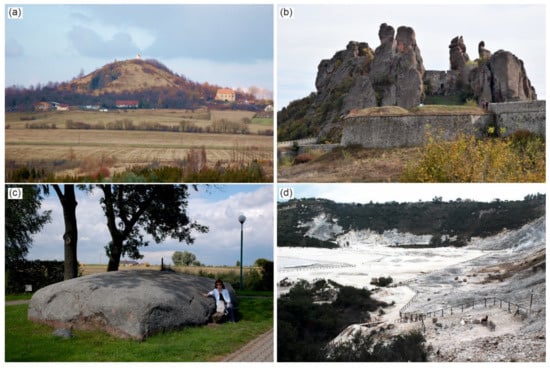
Figure 1.
Geomorphosites with additional cultural values. (a) cinder cone of Zebín in the Bohemian Paradise UNESCO Global Geopark is an important geosite, with the medieval church at the foot (right) and a baroque chapel on the top, (b) conglomerate rock city of Belogradchik, Bulgaria, with remnants of the Kaleto fortress incorporated into it, (c) a large erratic boulder in central Poland (Budziejewko village), associated with various local legends, (d) Solfatara in Pozzuoli, Italy, is a world-renowned volcanic geosite, visited and used for therapeutic reasons since antiquity (all photographs by the authors).
Landforms, rather than geological outcrops, represent most of geoheritage sites with these associations, which is understandable given their often prominent position within a regional landscape. Thus, these geoheritage sites may be also considered as geomorphosites [6]. Typical geomorphosites of this kind are distinctive terrain elevations (volcanoes and volcanic necks, inselbergs, dome-shaped hills, mesas, solitary pinnacles), crags and tors, cliff lines, both coastal and inland, canyons, gorges, and necks of entrenched meanders. Relevant smaller landforms include erratic boulders and their clusters, curiously shaped weathering features, rock shelters, gullies, and dolines. Caves may also belong to geoheritage of mixed significance [7], if they contain archaeological remains, examples of rock art (paintings, petroglyphs), or were used as hideouts or hermitage sites.
The dual, globally outstanding value, involving both geoheritage and cultural heritage, is demonstrated at UNESCO World Heritage mixed properties. Their total number is 39, as of early 2022 (www.unesco.org; accessed on 22 January 2022), although not all of them are recognized for geoheritage. Among sites recently presented are the travertine depositional features associated with an ancient town of Hierapolis in Pamukkale, Turkey [8], and conglomerate towers crowned by Orthodox Christian monasteries at Meteora in Greece [9,10], whereas the great sandstone sceneries of Tassill n’Ajjer (Algeria) and Ennedi (Chad) that include impressive rock art of outstanding value are still waiting for proper presentation of their geoheritage.
Some of the recently published studies emphasised spiritual [11] and military use of caves [12], their importance for archaeology and human history [13], the use of natural configuration of rock landforms to insert defensive structures such as castles and fortresses [14], and incorporation of modern architecture into natural rock-cut scenery [15]. Large erratic boulders in the formerly glaciated European lowlands areas have often acquired special cultural significance, being associated with pre-Christian cults, beliefs in supernatural powers, legendary or historical events [16,17]. These associations are also reflected in their names, containing references to evil spirits or saints. Huge granite boulders in granite denudational landscapes, especially if associated with intriguing microrelief (circular weathering pits, karren) may also bear similar associations, for instance in the Waldviertel area of Austria [18]. Multiple connections between volcanic phenomena and related landforms and diverse human activities over centuries were presented for the Campi Flegrei area in southern Italy [19], whereas in the Swabian Alb, southern Germany, various karstic sites (caves, tufa cascades, springs) have strong associations with local cultural heritage [20,21].
3. Urban Geoheritage and Heritage Stones
Exploration of geoheritage in an urban context is among the most frequently addressed themes at the geoheritage/cultural heritage interface. It is close to urban geomorphology on the one hand, which examines how landform patterns influence location and growth of towns and cities [22], but crosscuts the heritage stone issues, ranging from conservation challenges at historical monuments to the identity of a city due to preferential use of a certain kind of building stone. Thus, specific subjects also vary in the spatial scale of inquiry, from a singular building to the whole-city layout and appearance (Figure 2).
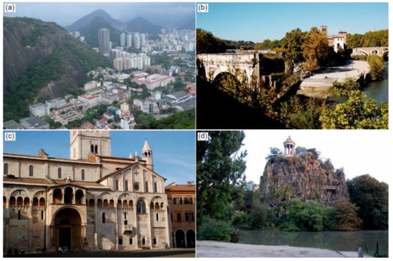
Figure 2.
Examples of urban geoheritage of different kinds and scale. (a) the city of Rio de Janeiro developed amidst large granite-gneiss domes, (b) Tiberina Island in the centre of Rome is a much altered natural gravel bar of the river Tiber, (c) a romanesque cathedral in Modena, Italy, built of various building stones, (d) Parc des Buttes-Chaumont—an old gypsum quarry in the centre of Paris, converted into a municipal park (all photographs by the authors).
Some towns and cities are presented as examples of how urban planning, often going back to medieval times or even beyond, was adjusted to natural topography and spatial domains of ongoing geomorphic process, thereby enhancing local geoheritage rather than erasing it [23,24,25]. In Rio de Janeiro, this symbiosis between superb granite geomorphology, with its numerous steep-sided domes [26,27], and specific urban design and culture was even emphasised in the justification of outstanding universal value, decisive for the city’s inscription on the UNESCO World Heritage list as an urban cultural landscape (Figure 2a).
However, accelerated urban growth coupled with increasing engineering abilities has led to the situation that natural landform features no longer control pathways of urban development, but may have been eliminated if that was considered necessary. The respective engineering solutions include valley filling, channel relocation, slope grading and hilltop trimming, with the common denominator being the ultimate disappearance of a landform. In specific places, these disappeared landforms may have been of geoheritage value. Recently reviewed examples include Rome [28] and Genoa in Italy [29], Lausanne in Switzerland [30], Mexico City [31], Perugia [32], Toruń in Poland [33], Brno in the Czech Republic [34], and Auckland in New Zealand [35].
Despite the inevitable loss of geodiversity and geoheritage due to urbanization, or perhaps in response to it, a voluminous literature concerns recognition of geoheritage sites within urban space. Some publications deal with classic localities, appreciated for more than a century, such as the giant glacial potholes in Luzern, Switzerland [36], but there is an increasing trend to present less evident cities and towns to an international audience. For some of these, local language literature may have been available earlier, but broadly accessible sources were missing. Places of recent interest include São Paulo [37], Lisbon [38,39], Poznań [40], Segovia [41], Oslo [42], Khorramabad in Iran [43], Brno [34,44], Ljubljana in Slovenia [45], and Zagreb in Croatia [46]. Apart from large cities, small towns are also occasionally evaluated in this context, such as Pruszków in Poland [47]. However, in many of these cases the assessment of urban geoheritage is limited to sites of geological interest, mainly natural or artificial bedrock outcrops, whereas geomorphological heritage and viewing points allowing for examination of geomorphological scenery are considered less often. This imbalance may be partly related to the intensity of urban development but may also reflect specific interests of particular authors. Thus, the diversity of urban geoheritage was presented by Pica et al. [28] for the heart of Rome (ancient Rome), where geomorphological, hydrological, and stratigraphical geosites were identified (Figure 2b), whereas in Mexico City, attention was directed to the remnants of the lake, the use of ornamental stones, and old lava flows, the latter encroaching onto a pre-Hispanic ceremonial centre at Cuicuilco, with its partly buried round pyramid [31]. In Segovia, as many as 94 potential geosites belonging to 16 thematic categories were documented [41], whereas in Brno, 89 localities were analysed in terms of scientific (geoheritage, geodiversity) and added values, the latter including cultural associations [48].
A theme in its own right is heritage stone, usually analysed in an urban context (Figure 2c), even though its use in vernacular architecture is also addressed [38,49,50,51,52,53,54,55,56,57,58,59,60]. De Wever et al. [50] reviewed the significance of geosites and heritage stones in a more general way, providing numerous examples from European cities of how background geological knowledge may be used to design rock-focused geotrails, leading visitors to famous historical buildings erected from characteristic stones and to the very sites of stone extraction, that is ancient quarries now located within city limits or just outside. These examples include the towns of Salamanca in Spain, Bath in England and Paris, where an old gypsum quarry at Buttes-Chaumont was converted into a large park (Figure 2d). Some publications are deliberately focused on one or two rock types, most used in a region. In the Segovia province in Spain, rock colour determines the visual appearance of villages, named as ‘red hamlets’ (pueblos negros) and ‘black hamlets’ (pueblos rojos). These differences reflect the use of traditional building materials, Miocene red gossan breccias and Ordovician-Silurian black slates, respectively [61]. Further examples include the use of Arrábida Breccia in manueline-style buildings in central Portugal [62], Red Ereño limestone in the Basque Country, Spain [63], and green phyllite used for roofing in Lugo in Galicia, Spain [64]. This geoheritage-oriented approach to building heritage is not limited to Europe. Numerous recent papers have documented heritage stone use in India, including basalt [65], marble [66,67], sandstone in Rajasthan province [68], limestone [69], slate [70] and quartzite [71]. Other studies have been focused on particular regions rather than specific building stones, as exemplified by a recent thorough study of historic stones used in construction of churches and chapels in West Sussex, England [72], examination of geological foundations of Japanese castles [73], or inclusion of more than 30 historical structures into a comprehensive geoheritage and geodiversity assessment in the Sudetic Foreland Geopark, Poland [74]. It is also observed that building stones, as well as pavement tiles, may contain fossils and hence, are suitable for palaeontological education for the general public [75,76,77,78]. Valentino et al. [79] described special mobile applications designed to help recognizing rock types used in architecture. The range of heritage stone themes was recently expanded by consideration of lighthouses [80] and cemeteries, where various rock types are used as tombstones and in sepulchral art. A notion of ‘cemeterial geotourism’ was recently proposed [81,82].
Geosites other than rock outcrops, landforms and buildings are seldom addressed. However, the significance of hydrological sites, mainly springs and ancient wells, has been realized in Rome [28], Perugia [83], and Lisbon [84].
4. Cultural Landscapes
The relevance of geoheritage to cultural landscapes and various relationships between the two have been recently comprehensively reviewed by Gordon [2]. The contribution of abiotic components is very diverse, ranging from crucial underpinning of the landscape [85,86], evident in its rock- and/or landform-controlled appearance, to incorporation of minor and not necessarily very significant elements into a landscape that is dominated by anthropic elements, with all possible intermediate situations. Consequently, the spatial extent and specific characteristics of cultural landscapes twinned with geoheritage vary too (Figure 3). Although a complete typology is difficult to propose, notable examples include: (a) rugged countryside adjusted to become an agricultural area through an introduction of terracing and stone walls, (b) romantic parks and gardens built around distinctive natural landforms, (c) rural settlements constructed with the pervasive use of distinctive stone types, (d) certain mineral extraction areas, where technology required modification of natural relief (e.g., salt extraction ponds—salinas), (e) adjustments of natural topography to better serve defensive purposes, (f) rugged rock landscape, as settings of monastic complexes and other sites of spiritual significance, and (g) cave dwellings incorporated into natural rock cliffs. Landscapes dominated by the legacy of mining may be also considered as cultural landscapes, even though alteration of the natural environment was usually quite substantial. This topic, closely linked with mining heritage issues, is presented more thoroughly in Section 5. Less evident and rarely explored in geoheritage context are land-use histories related to specific soils, giving rise to ‘soilscapes’ [87].
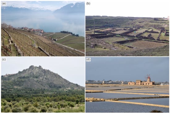
Figure 3.
Cultural landscapes illustrating various connections with abiotic nature. (a) terraced slopes of Lavaux Vineyards in Switzerland, with the glacial trough of Lake Geneva in the background, (b) stone walls built of local basalt and pieces of corals are part of endangered cultural heritage of Penghu Islands, Taiwan, (c) granite inselberg of Monsanto, Portugal, with the village built almost exclusively from local granite (left) and castle ruins on the hilltop, (d) salt pans near Trapani, Sicily, Italy (all photographs by the authors).
Cultural landscapes associated with agricultural production are perhaps best exemplified by rice fields and vineyards, the latter often located on steep hillsides of favourable soil and topoclimatic characteristics, significantly modified through terracing. As of 2021, 14 wine-producing regions in several European countries (Portugal, Spain, France, Switzerland, Italy, Germany) were listed as UNESCO World Heritage properties, recognized as cultural landscapes of outstanding universal value [88,89]. The analysis of documents demonstrated that the underpinning role of geology and landforms is increasingly recognized and recent nomination files for World Heritage give due attention to the abiotic factors [89]. An excellent example of very tight links between geology, landforms and land use is provided by the vineyards of Lavaux at Lake Geneva in Switzerland, inscribed in 2007 [90]. Here stepped hillsides are natural landforms and reflect repeating appearance of stronger conglomerates and less resistant sandstones and mudstones in the vertical geological profile. The former support mid-slope cliffs, whereas the latter underlie slope sections of lower inclination, developed as vineyard plots (Figure 3a). The terraced slopes of the famous Alto Douro wine district in Portugal is another recently presented case of close relationships between abiotic factors and wine culture [91]. Winescapes involving geoheritage value are not limited to World Heritage properties and famous wine regions but occur in other regions too [92,93,94,95].
The geoheritage context of stone-walled countryside sceneries is represented by the use of local stone to build the walls (Figure 3b), where availability of stone of specific shapes and dimensions as well as their other properties dictated construction technologies applied in specific localities [96,97,98]. Consequent to the realization that stone walls are part of combined geo-cultural heritage are studies of their degradation after abandonment, which is considered as a loss of value [99,100].
Incorporation of natural geomorphic and hydrological features into park and garden layouts was part of the 19th century romantic concept of ‘tamed wilderness’, implemented in Central and Western Europe. Using a specific example from an intramontane basin in the Sudetes it was shown how denudational granite landforms such as domes, tors, boulder piles, open and roofed clefts, overhangs, and minor weathering features became integral parts of landscape parks designed around royal and aristocratic residences [101].
Stone type used for construction of houses, street paving, plot-bounding walls and small architecture was long recognized as a factor defining the identity of rural settlements. This connection between abiotic and cultural spheres is often emphasized in European Geoparks, exemplified by heritage stone villages such as Monsanto in Naturtejo Geopark in Portugal, almost perfectly blended with the granite outcrops on the slopes of this impressive inselberg (Figure 3c), slate villages in the region of Valdeorras, Galicia, in Spain [102], or heritage villages in the Courel Mountains UNESCO Global Geopark, also in Spain [103].
Adaptation of existing caves, rock shelters and overhangs to serve as dwelling places, storage rooms and shrines has a long tradition in various parts of the world, especially where rock is simultaneously soft enough to allow for excavations, but sufficiently strong not to suffer from immediate wall or roof collapse. Tuffs and certain variants of sandstones fulfil these requirements and host extensive underground spaces used by people either in the past or, less commonly, until now. The archetypal example is the rock landscape of central Cappadocia, with its underground cities, rock-hewn churches, houses and pigeonholes [104], whereas multiple uses of natural and excavated hollows in sandstones were presented in the pictorial atlas of sandstone landforms of Czechia [105]. In limestone, in turn, natural caves were ready-to-use places for habitation, as documented from many countries worldwide, particularly from the Mediterranean realm. Further examples of cave dwellings were recently provided from the Basilicata region and Amendolara in southern Italy [106,107], Matmata in Tunisia [108], Vardzia and Uplistsikhe in Georgia [109], and from the Mekong Delta in south-east Asia [11].
A small-scale example of adaptation of natural landforms to serve economic purposes is offered by rocky shore platforms, modified into patterns of interconnected shallow pans to allow for salt harvesting [110,111,112]. Locally, salt pans were also developed in inland sites (Figure 3d) [113].
Defensive cultural landscapes may take different shapes and exploit various natural features. In the coastal context, Schembri and Spiteri [114] examined the pattern of drowned valleys (rias) on the north-eastern coast of Malta and how it underpinned the long-term strategy to fortify the city of Valletta and adjacent settlements, then the headquarters of the St. John’s Order. Another great example is provided by Hadrian’s Wall in northern England, where the 2nd century AD fortifications from the times of the Roman Empire were erected on the top of a long dolerite ridge, which is a distinctive rock-controlled landform and regional landmark [115]. In a similar vein, the association of the walled city of Luxembourg with the natural scenery of sandstone cliffs and canyons was examined [116]. All these three localities are UNESCO World Heritage cultural properties. Even though the geological underpinnings themselves are not considered of outstanding universal value, they were crucial for the appearance and significance of these defensive facilities.
Human perception of some rugged rock landscapes as locations of spiritual significance, present in various cultures and religions across the world, resulted in visitations, erection of temples and hermitages, and eventually transformation of the entire physical landscape, which however retained the main scenery values. The most impressive examples have the status of UNESCO World Heritage properties, such as Meteora in Greece, where monasteries were built atop rock pillars built of conglomerates [10]. Many impressive rock landscapes in China, valued for their geology and geomorphology, are closely associated with Taoism and Buddhism, as reflected in the presence of temples, shrines, tombs, sacred wells etc., connected by an intricate network of paths and staircases, with accompanying minor monuments and statues [117]. The theme of sacred meaning of natural landforms, present in different cultural environments of the world, and how they are used by people nowadays, was comprehensively reviewed by Kiernan [118].
5. Mining and Quarrying Heritage
The use of natural mineral resources is another frequently explored theme at the interface of geoheritage and cultural heritage. Two interlinked aspects may be distinguished within these inquiries, related to on-site exploitation and testified by mines, quarries and other sites of extraction, as well as to the fate of rock blocks and other materials retrieved from sites of exploitation, including means of their transportation to destination sites. The latter bridges the gap between mining heritage and heritage stone, covered in Section 3.
Within this broad theme, on the one hand, it is the rock itself and its various properties that are of interest. An important point is that quarries and mines often offer excellent opportunities to examine rock complexes in three dimensions, over areas usually larger than natural outcrops [119,120,121]. Hence, geologists have a long-standing interest in monitoring quarry operations, to update three-dimensional views of rock masses and all inherent structures. It is also not surprising that abandoned quarries (and occasionally working ones as well) are listed as geosites within regional or national inventories [122,123]. On the other hand, more relevant to this paper, quarrying and mining are parts of cultural heritage, with tangible evidence not limited to the quarry faces/mine adits themselves, but extended over processing plants, mine buildings, transportation routes, waste heaps, collapse hollows above ancient exploitation chambers, etc. [124,125,126]. Quarry layouts and mine galleries reflect engineering and working skills of quarrymen and miners and were often carefully adjusted to local geological conditions to minimize physical efforts and expenditures and to maximize effectiveness [127,128]. Mining and mining-related heritage is also presented and analysed in the wider spatial context, as a key factor contributing to the identity of a region, linking to the theme of cultural landscapes addressed more comprehensively in Section 4. Selected examples include former areas of tin extraction in Cornwall [86,129], copper and lead mining in southern Spain [130], and roofing slate exploitation in eastern Czechia [131]. There are also publications, which focus on specific types of stone resources and address various associated issues such as geological context, techniques of extraction, past and present use, as well as potential geoheritage value [103,132,133,134,135].
The cultural dimension of mining and quarrying has received an increasing recognition from the World Heritage Committee of UNESCO and currently more than 20 former sites of natural resource exploitation are listed as World Heritage properties in countries such as Great Britain, Germany, Czechia, Sweden, Spain, Poland, and Chile. Among the most recent examples is the Erzgebirge/Krušnohoří Mining Region along the Czech/German border, inscribed in 2019 and consisting of 22 key localities on both sides of the border (Figure 4). Each of these, in turn, encompasses several more sites of interest. The area was a mining region since the 12th to the 20th century and was particularly thriving in the 15th and 16th centuries when most of silver available in Europe came from the Erzgebirge mines.

Figure 4.
Mining heritage of Erzgebirge/Krušnohoří Mining Region—a transboundary UNESCO World Heritage property in Czechia/Germany. (a) evidence of exploitation of ore-bearing veins near the town of Horní Blatna, Czechia, (b) waste heaps and terrain depressions after collapsed shafts on Mt. Mědnik, Czechia, (c) remnants of a large tin mine in Geyer, Germany, (d) preserved traditional buildings of an old mining town, Horní Blatna, Czechia (all photographs by the authors).
With the contemporary increasing interest in geotourism, which includes mining heritage attractions, more and more quarries are being developed for tourists and offer educational opportunities. Reflecting this trend, various recent publications explore possibilities to use mining heritage as a foundation for geotourism development [136,137,138,139,140,141,142,143,144,145,146,147,148], although it was also pointed out that tourist visits to mining sites are hundreds of years old [149]. Various means of conveying information are employed at currently accessible sites, from individual information panels through discovery routes within individual quarries to longer trails linking adjacent quarries or mining heritage sites [150]. Conversion of a former underground mine into a tourist site usually requires a lot more effort and observation of the legal framework that controls the maintenance of underground mine spaces. Nonetheless, old mines of coal, gold, silver, ores, salt, flint, and chert, are increasingly popular visitation sites, and guided tours typically combine information about geological foundations, history of discovery, mining operations, and the use of a given resource in the past and at present [151]. Besides geotourism, Prosser [152] has recently shown the potential of quarrying to make connections with the local communities, emphasizing extraction of stone resources since antiquity as part of local history, the use of stone in buildings well-known to the locals, including dwelling houses in which they still live, conversion to local recreation grounds, and various educational initiatives implemented within former quarries.
Exploration of mining heritage extends to include industrial activities, which do not necessarily produce lasting visible evidence and do not create ‘mining landscapes’ but contribute to the cultural history of the region. This is the case of petroleum industry [146,153,154,155].
6. Cultural Heritage Dimension of Natural Geophysical Disasters
Natural processes, particularly catastrophic ones, often interfere with cultural heritage, damaging the latter or destroying it completely (Figure 5). Recent examples of substantial loss of cultural heritage include large-scale destruction of UNESCO World Heritage properties in Kathmandu, Nepal, due to the Gorkha earthquake in April 2015, an earlier damage of another UNESCO site in Bam, Iran, caused by an earthquake in 2003, and the consequences of the 2008 Wenchuan earthquake in Sichuan, China. However, ongoing exogenic processes may also pose a serious threat to sites of cultural significance, as shown by examples of heritage-listed religious sites of Hinduism affected by fluvial erosion and channel shifts of the Brahmaputra river in India [156], recurrent landslides, slow-moving slope deformations and gully erosion affecting historical settlements and structures in Italy [157,158], or historical buildings in the town of Calatayud in Spain, suffering from gypsum dissolution and land subsidence [159]. The ruined medieval church in the village of Trzęsacz in NW Poland, perched atop a coastal cliff (Figure 5a), is another example of a historical site that suffered from geomorphic processes, but one can also argue that its significance actually increased, being now also important for coastal geomorphology as a benchmark of long-term erosion [160]. In a similar way, the significance of the landslide-affected town of Bagnoregio in Italy has risen, especially after the opening of a dedicated landslide museum in 2012 [158]. Less dramatic in the long-term are consequences of river floods, commemorated by flood marks found on buildings located next to river channels (Figure 5b) [161,162,163].
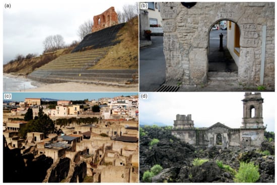
Figure 5.
Natural hazards and disasters in the cultural heritage context. (a) remnants of a medieval church in Trzęsacz, northern Poland, destroyed due to sea cliff retreat, (b) flood marks in the town of Eibelstadt on the River Main, Germany, (c) ruins of Herculaneum, Italy, excavated from beneath lahar and pyroclastic surge deposits from the AD79 eruption of Mt. Vesuvius, (d) ruins of a church in San Juan Parangaricutiro, Mexico, destroyed by a lava flow from the Parícutin volcano in 1944 (all photographs by the authors).
Of special interest are localities where everyday life in ancient times was suddenly interrupted by natural events such as volcanic eruptions, including lava flows or pyroclastic deposits overwhelming buildings, or earthquakes. These sites, if uncovered by archaeologists, become windows to the past of unprecedented importance, but they also show complex relationships between people and nature and can be used for geo-education [164,165]. The ruins of Pompeii and Herculaneum continue to attract interest of scientists exploring the history of their destruction by the 79AD eruption of Mt. Vesuvius (Figure 5c) [166,167]. Likewise, the site of Akrotiri on the island of Santorini has become famous due to its preservation after the catastrophic explosion of Thera volcano around 1600 BC [168]. Perhaps less known are the ruins of the pre-Columbian ceremonial site of Cuicuilco in Mexico City, partly buried by lava flows some 1670 ± 35 years BP, in this case probably long after abandonment by the local population [31]. There are also various examples of ancient structures destroyed by earthquakes, particularly in the Mediterranean world [169,170,171].
For more recent natural disasters, one can argue that the very fact of partial destruction turned a place, which would be fairly ordinary otherwise, into a site of mixed, natural-cultural importance. This is the case of the former village of San Juan Parangaricutiro in Mexico, overwhelmed in 1944 by a lava flow fed by the Parícutin volcano [172]. The sole vestige of the town is the ruined church, partly filled by lava, with the tower rising above the rugged lava surface (Figure 5d). The church itself was of minor architectural significance, but after the eruption the site has become a tourist attraction, whereas for the local population it is also a pilgrimage site and a sign of supernatural protection of the church. Similarly, towns and villages abandoned following strong earthquakes, recurrent landslides, and flood disasters, turning into ‘ghost towns’ if they were not totally demolished, may also become localities of combined geoheritage and cultural significance as testaments of the power of natural forces [173].
This field of inquiry is also closely related to geo-mythology and other intangible cultural heritage, as will be discussed in Section 10.
7. Geoheritage and the History of Science
A substantial part of geoheritage is linked with the history of Earth sciences, which is another part of cultural history. Of particular importance are localities where significant observations and discoveries were made, so that these sites have become benchmarks for subsequent studies. These discoveries are in turn connected with the names of people, who were later recognized, as geosciences developed, as the leading representatives of academia, influential researchers, and founders of ‘schools of thought’, which may have lasted for many decades. In these cases, relevant geosites do not only inform about specific rocks, fossils or structures, but also provide opportunities to recall the life and contribution of an eminent scientific figure. In addition, the further back in time we go, the more often authors of these observations were not highly specialized geologists, but rather people of broad interests and multiple skills, including poetry and art, and well-travelled.
These discoveries are usually recalled by erecting simple commemorating plaques or interpretation panels at the sites of concern. The former, however, add a cultural dimension to a geosite (e.g., localities visited by Johann Wolfgang Goethe in the sandstone tablelands of Central Europe [174]), but do not help to better understand the significance of a site. By contrast, the latter inform about the nature of the scientific achievement and sometimes about the persons themselves, as in the case of Hutton’s Section in Edinburgh, Scotland, where James Hutton demonstrated the intrusive origin of a dolerite dyke. In fact, England and Scotland are areas where many important discoveries were made during the early stages of Earth science development, and these are brought back to attention through both more specialist publications aimed at professionals and efforts to explain the sites themselves to the general public [175,176]. The history, scientific content, and educational role of geological collections in museums is another recurrent theme in recent publications, illustrating another dimension of geoheritage and history of science linkages [177,178,179,180]. For example, Hose [177] summarized the main characteristics of leading geological museums in England, France, Italy, and Germany, whereas Vicedo et al. [181] emphasized the value of movable palaeontological heritage collected in the Museum of Natural History in Barcelona.
In the city of Prague, Czechia, an educational trail was set up in the valleys of Dalejské and Prokopské údoli, where numerous limestone quarries expose a marine succession of Ordovician, Silurian, and Devonian age, including some globally recognized stratotypes, most associated with the work of Joachim Barrande in the 19th century. At several stops, panels inform about the significance of these sites for the development of geology, whereas the quarries themselves are well exposed and easily available for viewing. Another recent study from Czechia recalls the contribution of J.W. Goethe to the Plutonism/Neptunism debate at the turn of the 19th century and his efforts to explain the origin of Komorná hůrka cinder cone [182]. The site itself preserves the original adit dug to test the hypothesis of volcanic versus marine origin of basalt, whereas interpretation panels put it into wider regional and scientific context. In the Alps, in turn, especially in Switzerland, numerous geosites are highly valued not only for their intrinsic value, but also for their importance for the advancements in the theory of mountain glaciation and mountain building [183]. The ruins of Serapeo in Pozzuoli, Italy, with perforations imposed by burrowing marine molluscs, played an important role in the understanding of cyclic sea-level changes and were immortalized on the cover of Lyell’s ‘Principles of Geology’, first printed in 1830 [184]. However, not all these important localities have on-site interpretation facilities, and the awareness of their significance is then limited to a rather narrow circle of professionals.
It is worth noting that advances in geosciences and the means to commemorate them are not limited to the Western world. Figure 6 shows a panel from Yandangshan UNESCO Global Geopark in southern China that recalls how a Chinese scholar Shen Kuo, living in the 11th century, explained the role of running water in eroding the rocks and the land.
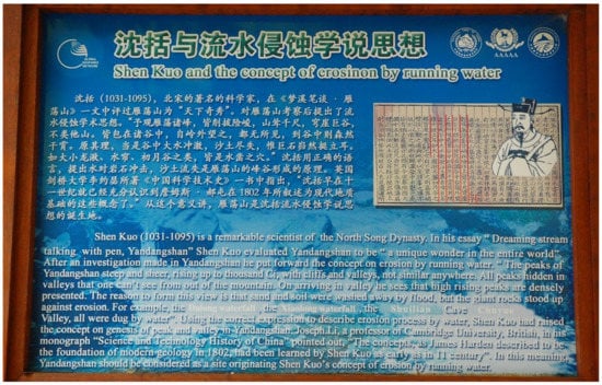
Figure 6.
Interpretation panel in Yandangshan UNESCO Global Geopark, China, referring to the history of scientific inquiry in the field of geosciences (photograph by the authors).
8. Geoheritage and Early Tourism
Tourism can be defined and analysed from various perspectives, but no one doubts that it is an inseparable part of culture. Whereas the extremely broad subject of contemporary geotourism, addressed in an ever-growing number of publications from all around the world, is beyond the scope of this review as it does not yet qualify as part of “cultural heritage”, early tourism with its tangible evidence and intangible legacy is certainly of heritage value.
In Europe, linkages between geoheritage and early tourism are best expressed in the context of “Grand Tours” of the 17th to 19th centuries. These travels are understood as long journeys undertaken by representatives of contemporaneous aristocratic elites, especially from western and northern Europe, with the Italian peninsula as the ultimate destination. The purpose was to become acquainted with the rich cultural heritage of Italy, traced back to Greco-Roman times, fulfilled through visits to famous historical cities (Venice, Florence, Rome) and sites of archaeological importance (e.g., Pompeii). However, many Grand Tour practitioners travelling across the Alps and the Italian peninsula did not ignore impressive natural features such as the glaciers and high-mountain scenery of the Alps [171]. In Italy itself, active volcanoes such as Mt. Vesuvius, Mt. Etna and the Aeolian Islands aroused curiosity, and so did related geothermal phenomena such as those at Campi Flegrei near Naples, and the interest can be traced back into antiquity [19]. Sometimes it is not straightforward to draw a clear dividing line between early tourism and the development of science (see Section 7). A recent project aimed to refresh the memory about the long journey of J.W. Goethe across Italy in the late 18th century and to highlight the aptness of his observations about geology and landscapes [185]. Thus, the travelling Goethe was as much a person undertaking the Grand Tour and a geotourist, as he was a naturalist, whose efforts to understand the environment are documented in his travel memoirs.
In a different geographical context, Migoń [174] reviewed the history of tourism in the Sudetes range in Central Europe, noting an interest of 18th century travellers in sandstone rock cities and the evidence of amazement in these unique rock formations recorded in travel diaries. Likewise, the nearby Karkonosze Mountains and their surroundings attracted tourists offering vistas of unusual geomorphic formations such as waterfalls, glacial cirques (not interpreted as such in those times), non-karstic fissure caves, and granite tors [101,174]. In the 19th century, the Sudetes, like many other mountains and uplands in the contemporaneous German lands, were renowned for their sites of geological and geomorphological interest. In Britain, the Romantic period between the late 18th and mid-19th centuries saw a surge of interest in natural landscapes too, as extensively documented for the wild Lake District in northern England [186] and other parts of England [187]. Gordon and Baker [188], in turn, drew attention to the “tourism of awe” that typified the 18th and 19th century visits to the Scottish Highlands, emphasizing ubiquitous appreciation of wild Highland scenery, with waterfalls, glacial troughs, and outcrops of columnar jointing in basalts. A related theme is early geotourism provisions, such as purposefully designed guidebooks [189] and outdoor geological models [174].
9. Geoheritage, Art and Literature
Linkages between geoheritage and art are not among the most popular topics and were explored in a rather limited number of publications, even though opportunities of thematic studies are multiple [190,191], but this may change, following the recent plea of Motte and McInnes [192] that “it is stimulating to continue the adventure of bridging sciences and art”. Nevertheless, various studies have been recently published, addressing subjects such as natural landscape features as a source of inspiration for artists, or the use of old paintings to inform attempts to decipher landform change in the past few centuries. In this context, art presentations of sites that were subsequently destroyed, either by natural forces or due to human activities, are of particular importance. A relevant example is the site of the White and Pink Terraces in the North Island of New Zealand, once acclaimed a ‘wonder of the world’, but irreversibly annihilated through the explosion of the Tarawera volcano in 1886 [193]. In the Alps, the pre-20th century artistic imagery is now a most useful source of information about past extents of glaciers, used in conjunction with other lines of evidence [194]. In a similar vein, analysis of old paintings, postcards, and engravings of the coastal scenery in Brittany, France, helped understanding the patterns of coastal change and may inform current coastal management [192]. Pullin [195] offered an insightful analysis of the life and work of Eugene von Guérard, a 19th century landscape painter of German origin, who began his career in Germany, but spent many years in Australia and New Zealand, portraying various volcanic features with a very high degree of accuracy. The common use of sites of geological or geomorphological significance as motifs for landscape paintings was also emphasized for the Scottish Highlands [188], the Isle of Wight in southern England [196], the chalk cliffs of the island of Rügen in Germany [191], and badland landscapes of Italy [197]. Landscape paintings from the period of the Renaissance (15th–16th century) were analysed by Nesci and Borchia [198], who aimed to see if the landscape backdrops were imaginary or real sceneries, confirming the latter. Further examples and relevant references were provided in a brief, but informative overview of the subject by Gordon [190].
Art other than painting is rarely presented in the context of geoheritage. One novel aspect is exploration of the content of municipal heraldry in Portugal, with the emphasis on geological and geomorphological elements demonstrating close links with the landscape and the sense of place underpinned by physical features [199]. The appearance of landscapes of geoheritage value in movies and related opportunities for geotourism has also been recently addressed [200].
Natural landscapes and individual curious landforms have often been inspirational to poets and writers, especially in the Romantic period of the 19th century, so that one can find various direct and indirect references to diverse geological and geomorphological phenomena [190,191]. Examples of this kind demonstrate the cultural value of geoheritage and add value to localities otherwise important for scientific reasons.
10. Geoheritage and Intangible Cultural Heritage
The last two decades have seen an increasing awareness of the contribution that intangible cultural heritage offers to better appreciate and understand geoheritage. As for the other themes, this one too appears in various forms such as preservation of memory of natural geophysical disasters and their consequences, explanation of natural processes by indigenous communities unfamiliar with the scientific foundation of geoheritage, traditions related to various aspects of natural heritage, and reconstructed geo-mythology.
Geo-mythology issues were reviewed and illustrated by diverse examples from around the world in an edited work [201], which highlighted its importance for geological sciences. Various authors demonstrated that mythical events embedded in the collective memory of indigenous communities and related place names may in fact inform about catastrophic geophysical events such as earthquakes [202,203,204], tsunamis [205,206], or dramatic environmental changes due to climate change and ice expansion [207]. The most recent additions to the subject are the scholarly monograph by Burbery [208] and a review of folk tales related to submerged lands due to sudden or gradual geophysical change by Nunn [209]. However, possible linkages between the content of tales and real geological events have to be explored with extreme care due to possibilities of various recent ‘contaminations’, as demonstrated by referencing to Aboriginal stories about ‘falls from the sky’, which could be interpreted as eye-witnessed meteorite impacts but were in fact inconsistent with the timing of the origin of craters [210]. The iconic Mount Olympus in Greece was also presented in the context of ancient mythology versus modern geology [211], whereas Khoshraftar and Farsani [212] argued that geo-mythological associations at cultural heritage sites may increase interest among visitors, which in turn can be used to offer more comprehensive interpretation of geosites.
In other cases, folk tales and associated traditions and rituals are not related to real events from the geological past but simply reflect beliefs of the local population passed on from the era prior to scientific discoveries in the field of geosciences. Exploration of such traditions in the geoheritage context seems to be an emerging theme, as demonstrated by recent contributions from the Bohemian Massif in Czechia [213], the Ardennes in Belgium [214] and Lithuania [17]. Geomorphological features subject to folk explanation include distinctively shaped rock outcrops, erratic boulders, dead-ice kettles, meander loops, and caves.
Apart from oral traditions passed on from one generation to another, geoheritage connections may be also found in traditional tattooing, specific phrases used in local languages, and cultural activities [215].
11. Geoheritage—Added Value at Cultural Heritage Sites
In Section 2 and Section 4, we presented geoheritage sites, which show an additional value associated with cultural heritage. However, the relationship can be also in reverse, in that cultural values are considered as superior, but this should not lead to the neglect of geodiversity and geoheritage aspects at these sites. This issue can be demonstrated at many UNESCO World Heritage sites, which were inscribed solely in the recognition of their cultural value but may contain interesting landforms and rock outcrops [216]. Selected recent examples of this kind, other than those referred to above, include:
- The artificial caves of Elephanta off the Bombay coast in India, with numerous paintings and sculptures, excavated in multi-layered basaltic lava flows. A recent publication [217] drew attention to the paucity of geological information about the site and aimed to redress the balance.
- The archaeological area of Aksum in Ethiopia, known for the famous stelae, subterranean necropolises and ruined buildings. These historical monuments are integrated with the erosional scenery of exposed syenite plugs, with impressive rock cliffs, talus-covered slopes and boulder blankets (Figure 7a) [218].
 Figure 7. Geoheritage context of selected UNESCO World Heritage cultural properties. (a) the archaeological area of Aksum, Ethiopia, with flat-topped syenite plugs, pediments and intriguing boulder fields, (b) granite residual hills and boulders in the cultural landscape of Sintra, Portugal, (c) graben in the lava plateau at Thingvellir, Iceland, testifies to recent crustal extension at the plate boundary, (d) magnificent sandstone and conglomerate cliffs provide the geomorphic context for the rock art site of Serra da Capivara, Brazil (all photographs by the authors).
 - The rock island of Mont-Saint-Michel in Normandy, France [219], made famous by the Benedictine Abbey erected on the top, but being also a first-class example of rock-controlled relief amidst megatidal flats.
- The Cultural Landscape of Sintra in Portugal, where various elements of the 19th century Romantic architecture, including gardens and parks, are incorporated into granite scenery with impressive crags and boulder fields (Figure 7b), giving way to sea cliffs and shore platforms [220].
- The archaeological site of Petra in Jordan, with numerous elaborate structures dated to the turn of BC/AD times, half-built and half-carved into striking red sandstone outcrops. Geomorphology provides a magnificent setting to the ancient city, with high cliffs, rock platforms, extremely narrow gorges, and a variety of selective weathering features [221].
- The Thingvellir area in Iceland, inscribed in recognition of its cultural significance for the history of parliamentary culture, but at the same time being “perhaps the best place on this planet to understand the process of rupturing of the crust in response to the pulling forces of plate movements” [222]. The site contains superb examples of open fractures, trenches and grabens, waterfalls and lava outcrops (Figure 7c).
It is also appropriate to mention rock art sites, which often sit amidst spectacular scenery, but the focus of research tends to be on the content and interpretation of paintings and engravings. Again, the UNESCO World Heritage list provides examples (e.g., Tadrart Acacus, Libya; Serra da Capivara, Brazil—Figure 7d) and there are many less known sites on all continents. Nonetheless, a few recent publications analysed the wider geological and geomorphological context of such localities [223,224] and consideration of environmental history may significantly help in interpretation of rock art and explanation of its current state [225]. Similarly, caves renowned for rock art or other archaeological discoveries are examples of mixed cultural-natural heritage and hence, geomorphosites, even though their core values are associated with the importance for the history of mankind [7,226,227].
12. Systematic Approach versus Multiple Linkages
The review above shows that the interface of geoheritage and cultural heritage is very broad, and many specific themes are explored, even though some appear more often addressed than others. In addition, in tracing recent literature one can easily observe that the range of such themes increases, and this trend is likely to continue in response to the expansion of the UNESCO Global Geopark Network, which emphasizes geoheritage—cultural heritage linkages, new international initiatives such as World Geodiversity Day, and a growing awareness among scientists that inter- and transdisciplinary studies have considerable merit. Therefore, it is tempting to offer a provisional systematic classification that would facilitate navigation across this increasingly complex field of inquiry. This, however, seems a challenging task as approaches to classification can be different, being not mutually exclusive (Table 1).

Table 1.
Various approaches (A–G) with their underlying factors important to classification of themes at the geoheritage—cultural heritage interface.
Perhaps the most obvious classification for geoscientists would be one that makes the type of geoheritage central, paying less attention to the kind of relationships with cultural heritage (Table 1, column A). This stance reflects the internal division of Earth sciences and defines the possible contribution that petrologists, palaeontologists, structural geologists and volcanologists, geomorphologists or hydrologists can have. However, some sub-disciplines may fit into several categories, especially volcanology, whose linkages with cultural heritage are often explored. Cultural dimension may be shown by specific types of volcanic rocks used for various purposes, volcanoes as singular landforms, volcanic landscapes, geothermal phenomena, as well as information about past eruptions. In this approach, the classification system may be easily expanded by adding sub-categories, for example defining types of landforms more specifically (fluvial, mass movement-related, volcanic, karst).
An opposite way involves the type of human activity as the basis of a classification system (Table 1, column B), as in each case the nature of relationships with geoheritage is different and includes exploitation and re-use (e.g., mineral resources and building stones), adaptation to natural conditions (town planning, farming in difficult terrains), adjustment to societal needs (adaptation of caves for visitors), or recording and interpretation (education, art).
The next two approaches emphasize the spatial and temporal scale, respectively. Considering space (Table 1, column C), one can categorize inquiries according to the size of an area at which the relationships are examined. The broadest scale is represented by cultural landscapes, where protracted human use of natural resources resulted in the origin of a distinctive scenery, whose appearance, both at large and in detail, is underpinned by geology and geomorphology. Terraced wine-growing landscapes and mining districts are relevant examples. Urban geoheritage follows, usually encompassing large areas, with several specific themes that are addressed. The main ones are adjustment of urban design to natural landforms and the use of several characteristic building stones across a city. However, large cities may be also considered as cultural landscapes, as exemplified by the UNESCO World Heritage-listed Rio de Janeiro. Rural heritage comes next, although again these small inhabited spatial units may be part of much wider cultural landscapes. Defining the boundaries between these categories in numerical terms seems thus neither possible nor helpful. The decreasing spatial scale is completed with individual objects (if the focus is on anthropic constructs such as buildings), or sites (landforms, rock outcrops). A category of its own is made by subterranean sites, not visible from the ground and not fitting any of the above categories. In fact, the size of subterranean sites may vary broadly, from small caves and single adits to extensive underground systems of quarries, mines and dwelling spaces. Classification in respect to timeline is another possibility, allowing for easier identification of potential partners in scientific endeavour (archaeologists, historians, art historians), but is unlikely to be universal. The proposal shown in Table 1 (column D) is obviously Mediterranean/Europocentric and reflects major phases of civilization development and historical breakthroughs experienced in this part of the world, but it will not be applicable to other continents. For instance, it will have little relevance to East Asia, nor to Australia and Oceania.
The mutual relationships between geo- and cultural heritage may also be examined from the perspective of tangibility/intangibility of evidence (Table 1, column E). The former is more explored and can be further divided into inquiries focused on in situ objects of interest (landforms, sites of exploitation of natural resources, hydrological phenomena etc.) and those, where objects of value are preserved ex situ (e.g., mineral and fossil collections). The latter, increasingly appreciated in the last few decades, may also warrant further subdivision depending on their type (language, mythology, customs etc.).
The review of publications has also shown that the position of geoheritage values in respect to cultural heritage varies (Table 1, column F). In some studies, geoheritage and geodiversity are central, whereas cultural associations are considered as added values that enhance the significance of a site. This approach is particularly common in valorization of geosites in the context of tourist use, underlined by an assumption that the diversity of values makes the site more attractive and allows for implementation of various innovative tools and concepts in geo-education. In other cases, however, a given site is primarily known for its cultural heritage values and the efforts of geoscientists are directed to show its less known face and perhaps to achieve some sort of balance in perception of significance, in response to the general limited awareness of geoheritage and geodiversity. Equal standing is another option, as demonstrated by UNESCO World Heritage mixed properties, where neither cultural nor natural values are superior in respect to one another. Finally, the main purpose and context of studies is emphasized, acknowledging that they often have a clearly defined end-user (Table 1, column G). Thus, some have a distinct geoconservation slant, aiming to deliver practical solutions how to save geological, geomorphological, mining or building stone heritage that may face various threats arising from ongoing development and deteriorating state of environment. Many publications explore the linkages in the context of geotourism and its possible enhancement, particularly with reference to geoparks and towns/cities, whereas others focus on opportunities to use these cross-disciplinary relationships in formal and informal education, both in- and outdoor. There are also studies, which are not addressed to the specific users at the time they are presented, but simply contribute to the enlargement of our knowledge and understanding of the environment and history.
One may thus ask if classifications in this particular context are useful at all. One observation clearly emerging from the literature review is that various themes and fields of inquiry are overlapping and interlinked. For example, the frequently addressed issues of mining and quarrying heritage, distinguished as a separate theme in this paper (Section 5), are closely connected with cultural landscapes and urban geoheritage due to use of quarried stone, overlap with the history of science, and may have links with early tourism (visitations of famous ancient quarries, such as in Carrara, Italy) and art, being recorded on paintings. Mining culture may also influence intangible local and regional heritage. Likewise, rock art is relevant to the geomorphological heritage, as rock art sites are usually associated with distinctive landforms, and history of geoscience, giving insights into past environmental changes. Geomythology and other expressions of intangible cultural heritage are linked with past geophysical disasters and may help to better understand the latter. For all these reasons, we also present an alternative way to show the wide thematic spectrum within the broadly defined geoheritage—cultural heritage interface, using a mind map (Figure 8). It shows the main and the less explored themes identified in this paper, also indicating some specific areas of interest, as well as including the most evident linkages between them. However, it should not be considered as an exhaustive, definitive proposal and more themes and connections can be added, reflecting the variety of subjects, approaches, and cultural contexts.
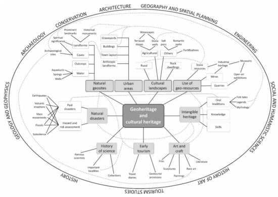
Figure 8.
Themes explored at the geoheritage—cultural heritage interface, divided into main (framed by thicker lines) and secondary ones, and the most evident connections between specific subjects (dashed lines). The outer ellipse shows sciences whose fields of interest overlap with geoheritage studies.
13. Conclusions
Two main conclusions emerging from this review are: (1) the cultural relevance of geoheritage is widely recognized and has become a very popular subject of studies, which explore various aspects of this interface, resulting in a broad range of themes and specific topics; (2) among these different themes some generate much more attention than others, resulting in general thematic imbalance. Among the most frequently addressed subjects are geoheritage in urban space, with particular focus on heritage stones and their use in historical building construction as well as on recognition of geosites and their accessibility, and mining/quarrying heritage, along with associated industrial architecture. The reasons are likely complex but may include both the urgent need for such studies, driven by conservation priorities, as well as the response to plans to increase or diversify tourist visitation. In each case, preferential funding may be available. Urban space is also an obvious place to explore for scientists based in respective cities. Apparently much less explored, at least by people with a geoscience background who publish in geoscience journals, are themes more linked with history such as history of scientific discoveries, of early tourism, and the whole sphere of art. The latter may seem a subject without significant implications for geosciences themselves, but this is not true. Old landscape paintings were shown to be valuable sources of information about landform change during historical times and may inform environmental management strategies. The literature survey also revealed a very uneven regional coverage. The vast majority of studies focused on relationships between geoheritage and cultural heritage came from Europe and the subject seems to grow in popularity in South America (specifically Brazil), whereas the heritage of Asian and African countries, as well as of Australia and Oceania, appears much less explored in this context, at least within leading international journals focused on geoheritage and geoconservation.
Recent years have seen an intensification of outreach activities among geoscience practitioners, arising from a growing realization that geoheritage and geodiversity do not enjoy sufficient recognition in society and their importance is often ignored [228,229]. Within this unfortunate situation, there is poor understanding of the crucial underpinning of many cultural values, both tangible and intangible, by geoheritage and geodiversity elements. Notably, whereas procedures of geosite assessment for education and geotourism purposes often include cultural elements as an added value, elevating the significance of a site and making it more appealing to the general public [230,231,232,233], cultural heritage is often assessed without due attention paid to its landscape context. One type of evidence supporting this statement is the inscription of many UNESCO World Heritage cultural properties, which undoubtedly owe their unique characteristics to the natural setting (e.g., rock art sites, sacred mountains, mining heritage), but the setting itself is rarely highlighted. Consequences of this bias are a lack of awareness of geoheritage values among visitors, even at sites with spectacular geoheritage, as recently demonstrated via a visitors’ survey at Meteora in Greece [234], or in the sandstone rock cities in the Bohemian Paradise UNESCO Global Geopark [235]. Therefore, a key research priority is action to foster understanding of geoheritage as a foundation value for cultural heritage, which can be achieved by publications exploring geoheritage and geodiversity of sites and areas recognized mainly for their cultural values. Parallel to that could be practical involvement in communication and promotion of geoheritage at cultural heritage sites to achieve more integrated interpretation offered to visitors. On the other hand, links with cultural heritage are worth underlining at primarily geoheritage sites too, as they may relate more immediately to popular experience and interests. Likewise, studies of under-researched themes, such as geoheritage in art and geoheritage, and geodiversity-related intangible cultural heritage also emerge as priorities.
Author Contributions
Both authors have equally contributed to the manuscript. All authors have read and agreed to the published version of the manuscript.
Funding
This research did not receive any specific funding.
Acknowledgments
We are grateful to three reviewers for undertaking the review, particularly to Reviewer no. 1 for suggestions how to strengthen the paper, additional bibliographic hints, and all linguistic corrections.
Conflicts of Interest
The authors declare no conflict of interest.
References
- Brockx, M.; Semeniuk, V. Geoheritage and geoconservation—History, definition, scope and scale. J. R. Soc. West. Aust. 2007, 90, 53–87. [Google Scholar]
- Gordon, J.E. Geoheritage, geotourism and the cultural landscape: Enhancing the visitor experience and promoting geoconservation. Geosciences 2018, 8, 136. [Google Scholar] [CrossRef] [Green Version]
- Reynard, E.; Giusti, C. The landscape and the cultural value of geoheritage. In Geoheritage. Assessment, Protection, and Management; Reynard, E., Brilha, J., Eds.; Elsevier: Amsterdam, The Netherlands, 2018; pp. 147–166. [Google Scholar]
- Olson, K.; Dowling, R. Geotourism and cultural heritage. Geoconserv. Res. 2018, 1, 37–41. [Google Scholar] [CrossRef]
- Pásková, M.; Zelenka, J.; Ogasawara, T.; Zavala, B.; Astete, I. The ABC concept—Value added to the Earth heritage interpretation? Geoheritage 2021, 13, 38. [Google Scholar] [CrossRef]
- Reynard, E. Geomorphosites: Definitions and characteristics. In Geomorphosites; Reynard, E., Coratza, P., Regolini-Bissig, G., Eds.; Pfeil Verlag: Munich, Germany, 2009; pp. 9–20. [Google Scholar]
- Hobléa, F. Karstic geomorphosites: Managing subterranean natural-cultural heritage sites. In Geomorphosites; Reynard, E., Coratza, P., Regolini-Bissig, G., Eds.; Pfeil Verlag: Munich, Germany, 2009; pp. 189–200. [Google Scholar]
- Altunel, E.; D’Andria, F. Pamukkale travertines: A natural and cultural monument in the World Heritage List. In Landscapes and Landforms of Turkey; Kuzucuoğlu, C., Çiner, A., Kazancı, N., Eds.; Springer: Cham, Switzerland, 2019; pp. 219–229. [Google Scholar]
- Lazaridis, G. Caves in the conglomerates of the Meteora geosite (Greece). Cave Karst Sci. 2020, 47, 6–10. [Google Scholar]
- Rassios, A.E.; Ghikas, D.; Dilek, Y.; Vamvaka, A.; Batsi, A.; Koutsovitis, P. Meteora: A billion years of geological history in Greece to create a World Heritage Site. Geoheritage 2020, 12, 1–16. [Google Scholar] [CrossRef]
- Kiernan, K. Human impacts on geodiversity and associated natural values of bedrock hills in the Mekong Delta. Geoheritage 2010, 2, 101–122. [Google Scholar] [CrossRef]
- Kiernan, K. Impacts of war on geodiversity and geoheritage: Case studies of karst caves from northern Laos. Geoheritage 2012, 4, 225–247. [Google Scholar] [CrossRef]
- Sardella, R.; Iurino, D.A.; Mecozzi, B.; Sigari, D.; Bona, F.; Bellucci, L.; Coltorti, M.; Conti, J.; Lembo, G.; Muttillo, B.; et al. Grotta Romanelli (Lecce, Southern Italy) between past and future: New studies and perspectives for an archaeo-geosite symbol of the Palaeolithic in Europe. Geoheritage 2019, 11, 1413–1432. [Google Scholar] [CrossRef]
- Tronkov, D.; Sinnyovsky, D. Belogradchik Rocks, Bulgaria: Geological setting, genesis and geoconservation value. Geoheritage 2012, 4, 153–164. [Google Scholar] [CrossRef]
- Carreras, J.; Druguet, E.; Siddoway, C.S. Geological heritage beyond natural spaces: The Red Rocks Amphitheatre (Morrison, CO, USA), an example of syncretism between urban development and geoconservation. Geoheritage 2012, 4, 205–212. [Google Scholar] [CrossRef]
- Górska-Zabielska, M. The most valuable erratic boulders in the Wielkopolska region of western Poland and their potential to promote geotourism. Geo J. Tour. Geosites 2020, 13, 694–714. [Google Scholar] [CrossRef]
- Pukelytė, V.; Baltrūnas, V.; Karmaza, B. Geoheritage as a source and carrier of culture, Lithuania. Geoheritage 2022, 14, 8. [Google Scholar] [CrossRef]
- Migoń, P.; Michniewicz, A.; Różycka, M. Granite tors of the Waldviertel region in Lower Austria. In Landscapes and Landforms of Austria; Embleton-Hamann, C., Ed.; Springer: Cham, Switzerland, 2022. [Google Scholar]
- Costa, A.; Di Vito, M.A.; Ricciardi, G.P.; Smith, V.C.; Talamo, P. The long and intertwined record of humans and the Campi Flegrei volcano (Italy). Bull. Volcanol. 2022, 84, 5. [Google Scholar] [CrossRef]
- Megerle, H. Cultural values of geomorphosites within the Geopark Swabian Alb, Germany. Collect. EDYTEM 2013, 15, 149–154. [Google Scholar] [CrossRef]
- Megerle, H.E. Calcerous tufa as invaluable geotopes endangered by (over-)tourism: A case study in the UNESCO Global Geopark Swabian Alb, Germany. Geosciences 2021, 11, 198. [Google Scholar] [CrossRef]
- Thornbush, M.J.; Allen, C.D. (Eds.) Urban Geomorphology. Landforms and Processes in Cities; Elsevier: Amsterdam, The Netherlands, 2018. [Google Scholar]
- Reynard, E.; Pica, A.; Coratza, P. Urban geomorphological heritage. An Overview. Quaest. Geogr. 2017, 36, 7–20. [Google Scholar] [CrossRef] [Green Version]
- Vaz, T.; Zêzere, J.L. The urban geomorphological landscape of Lisbon. In Landscapes and Landforms of Portugal; Vieira, G., Zêzere, J.L., Mora, C., Eds.; Springer: Cham, Switzerland, 2020; pp. 295–303. [Google Scholar]
- Pelfini, M.; Brandolini, F.; D’Archi, S.; Pellegrini, L.; Bollati, I. Papia civitas gloriosa: Urban geomorphology for a thematic itinerary on geocultural heritage in Pavia (Central Po Plain, N Italy). J. Maps 2021, 17, 42–50. [Google Scholar] [CrossRef] [Green Version]
- Fernandes, N.F.; Tupinambá, M.; Mello, C.L.; Peixoto, M.N. Rio de Janeiro: A metropolis between granite-gneiss massifs. In Geomorphological Landscapes of the World; Migoń, P., Ed.; Springer: Dordrecht, The Netherlands, 2010; pp. 89–100. [Google Scholar]
- Silva, T.M.; Ferrari, A.L.; Tupinambá, M.; Fernandes, N. The Guanabara Bay, a giant body of water surrounded by mountains in the Rio de Janeiro metropolitan area. In Landscapes and Landforms of Brazil; Vieira, B.C., Salgado, A.A.R., Santos, L.J.C., Eds.; Springer: Dordrecht, The Netherlands, 2015; pp. 389–399. [Google Scholar]
- Pica, A.; Vergari, F.; Fredi, P.; Del Monte, M. The Aeterna Urbs geomorphological heritage (Rome, Italy). Geoheritage 2015, 8, 31–42. [Google Scholar] [CrossRef]
- Faccini, F.; Giardino, M.; Paliaga, G.; Perotti, L.; Brandolini, P. Urban geomorphology of Genoa old city (Italy). J. Maps 2021, 17, 51–64. [Google Scholar] [CrossRef]
- Pica, A.; Reynard, E.; Grangier, L.; Kaiser, C.; Ghiraldi, L.; Perotti, L.; Del Monte, M. GeoGuides, urban geotourism offer powered by mobile application technology. Geoheritage 2018, 10, 311–326. [Google Scholar] [CrossRef]
- Palacio-Prieto, J.L. Geoheritage within cities: Urban geosites in Mexico City. Geoheritage 2015, 7, 365–373. [Google Scholar] [CrossRef]
- Melelli, L. “Perugia Upside-Down”: A multimedia exhibition in Umbria (Central Italy) for improving geoheritage and geotourism in urban areas. Resources 2019, 8, 148. [Google Scholar] [CrossRef] [Green Version]
- Molewski, P. Anthropogenic degradation of dunes within a city: A disappearing feature of the cultural landscape of Toruń (Poland). J. Maps 2021, 17, 162–169. [Google Scholar] [CrossRef] [Green Version]
- Kubalíková, L.; Kirchner, K.; Kuda, F.; Bajer, A. Assessment of urban geotourism resources: An example of two geocultural sites in Brno, Czech Republic. Geoheritage 2020, 12, 7. [Google Scholar] [CrossRef]
- Németh, K.; Gravis, I.; Németh, B. Dilemma of geoconservation of monogenetic volcanic sites under fast urbanization and infrastructure developments with special relevance to the Auckland Volcanic Field, New Zealand. Sustainability 2021, 13, 6549. [Google Scholar] [CrossRef]
- Keller, B. Lake Lucerne and its spectacular landscape. In Landscapes and Landforms of Switzerland; Reynard, E., Ed.; Springer: Cham, Switzerland, 2021; pp. 305–323. [Google Scholar]
- Del Lama, E.A.; de la Corte Bacci, D.; Martins, L.; Motta Garcia, M.G.; Dehira, L.K. Urban geotourism and the old centre of São Paulo City, Brazil. Geoheritage 2015, 7, 147–164. [Google Scholar] [CrossRef]
- Da Silva, C.M. Urban geodiversity and decorative arts: The curious case of the “rudist tiles” of Lisbon (Portugal). Geoheritage 2019, 11, 151–163. [Google Scholar] [CrossRef]
- Pacheco, M.; Cachão, M. Urban geology of Lisbon: The importance of the National Palace of Ajuda (Lisbon, Portugal). Geoheritage 2021, 13, 84. [Google Scholar] [CrossRef]
- Zwoliński, Z.; Hildebrandt-Radke, I.; Mazurek, M.; Makohonienko, M. Existing and proposed urban geosites values resulting from geodiversity of Poznań City. Quaest. Geogr. 2017, 36, 125–149. [Google Scholar] [CrossRef] [Green Version]
- Vegas, J.; Díez-Herrero, A. An assessment method for urban geoheritage as a model for environmental awareness and geotourism (Segovia, Spain). Geoheritage 2021, 13, 27. [Google Scholar] [CrossRef]
- Erikstad, L.; Nakrem, H.A.; Markussen, J.A. Protected geosites in an urban area of Norway, inventories, values, and management. Geoheritage 2018, 10, 219–229. [Google Scholar] [CrossRef] [Green Version]
- Moradipour, F.; Moghimi, E.; Beglou, M.J.; Yamani, M. Assessment of urban geomorphological heritage for urban geotourism development in Khorramabad City, Iran. Geoheritage 2020, 12, 40. [Google Scholar] [CrossRef]
- Kubalíková, L. Cultural ecosystem services of geodiversity: A case study from Stránská skála (Brno, Czech Republic). Land 2020, 9, 105. [Google Scholar] [CrossRef] [Green Version]
- Tičar, J.; Komac, B.; Zorn, M.; Ferk, M.; Hrvatin, M.; Ciglič, R. From urban geodiversity to geoheritage: The case of Ljubljana (Slovenia). Quaest. Geogr. 2017, 36, 37–50. [Google Scholar] [CrossRef] [Green Version]
- Fio Firi, K.; Maričić, A. Usage of the natural stones in the City of Zagreb (Croatia) and its geotouristical aspect. Geoheritage 2020, 12, 62. [Google Scholar] [CrossRef]
- Górska-Zabielska, M.; Zabielski, R. Potential values of urban geotourism development in a small polish town (Pruszków, Central Mazovia, Poland). Quaest. Geogr. 2017, 36, 75–86. [Google Scholar] [CrossRef] [Green Version]
- Kubalíková, L.; Drápela, E.; Kirchner, K.; Bajer, A.; Balková, M.; Kuda, F. Urban geotourism development and geoconservation: Is it possible to find a balance? Environ. Sci. Policy 2021, 121, 1–10. [Google Scholar] [CrossRef]
- Borghi, A.; d’Atri, A.; Martire, L.; Castelli, D.; Costa, E.; Dino, G.; Favero-Longo, S.E.; Ferrando, S.; Gallo, L.M.; Giardino, M.; et al. Fragments of the Western Alpine Chain as historic ornamental stones in Turin (Italy): Enhancement of urban geological heritage through geotourism. Geoheritage 2014, 6, 41–55. [Google Scholar] [CrossRef]
- De Wever, P.; Baudin, F.; Pereira, D.; Cornée, A.; Egoroff, G.; Page, K. The importance of geosites and heritage stones in cities—A review. Geoheritage 2017, 9, 561–575. [Google Scholar] [CrossRef] [Green Version]
- Corbí, H.; Martínez-Martínez, J.; Martin-Rojas, I. Linking geological and architectural heritage in a singular geosite: Nueva Tabarca Island (SE Spain). Geoheritage 2019, 11, 703–716. [Google Scholar] [CrossRef]
- Freire-Lista, D.M.; Fort, R. Historical city centres and traditional building stones as heritage: Barrio de las Letras, Madrid (Spain). Geoheritage 2019, 11, 71–85. [Google Scholar] [CrossRef]
- Lezzerini, M.; Pagnotta, S.; Legnaioli, S.; Palleschi, V. Walking in the streets of Pisa to discover the stones used in the Middle Ages. Geoheritage 2019, 11, 1631–1641. [Google Scholar] [CrossRef]
- Pereira, D.; Perez-Castro, P. Art museums: A good context for outreach activities on natural stones and heritage. Geoheritage 2019, 11, 125–132. [Google Scholar] [CrossRef]
- Wolniewicz, P. Bringing the history of the Earth to the public by using storytelling and fossils from decorative stones of the city of Poznań, Poland. Geoheritage 2019, 11, 1827–1837. [Google Scholar] [CrossRef] [Green Version]
- Key, M.M.; Lieber, S.B.; Teagle, R.J. An historical geoarchaeological approach to sourcing an eighteenth century building stone: Use of Aquia Creek Sandstone in Christ Church, Lancaster County, VA, USA. Geoheritage 2020, 12, 4. [Google Scholar] [CrossRef]
- Dreesen, R.; Poty, E.; Mottequin, B.; Marion, J.-M.; Denayer, J. An exceptional Lower Carboniferous historical heritage stone from Belgium, the ‘Pierre de Meuse’. Geoheritage 2021, 13, 100. [Google Scholar] [CrossRef]
- Kubalíková, L.; Zapletalová, D. Geo-cultural aspects of building stone extracted within Brno City (Czech Republic): A bridge between natural and cultural heritage. Geoheritage 2021, 13, 78. [Google Scholar] [CrossRef]
- Santi, P.; Tramontana, M.; Tonelli, G.; Renzulli, A.; Veneri, F. The historic centre of Urbino, UNESCO World Heritage (Marche region, Italy): An urban-geological itinerary across the building and ornamental stones. Geoheritage 2021, 13, 86. [Google Scholar] [CrossRef]
- Woodcock, N.H.; Furness, E.N. Quantifying the history of building stone use in a heritage city: Cambridge, UK, 1040–2020. Geoheritage 2021, 13, 12. [Google Scholar] [CrossRef]
- Oyarzun, R.; Duque, J.F.M.; Barrenechea, J.F.; López García, J.A. Gossans, slates, and the red and black hamlets of Segovia (Spain): Interrelated geological and architectural features. Geoheritage 2018, 10, 109–121. [Google Scholar] [CrossRef]
- Kullberg, J.C.; Prego, A. The historical importance and architectonic relevance of the “extinct” Arrábida Breccia. Geoheritage 2019, 11, 87–111. [Google Scholar] [CrossRef]
- Damas Mollá, L.; Uriarte, J.A.; Zabaleta, A.; Aranburu, A.; García Garmilla, F.; Sagarna, M.; Bodego, A.; Clemente, J.A.; Morales, T.; Antigüedad, I. Red Ereño: An ornamental and construction limestone of international significance from the Basque country (northern Spain). Geoheritage 2021, 13, 2. [Google Scholar] [CrossRef]
- Cárdenes, V.; López-Piñeiro, S.; Ruiz de Argandoña, V.G. The relevance of the green phyllites of Lugo (Spain) in the architectonical heritage: An exceptional roofing slate resource. Geoheritage 2021, 13, 11. [Google Scholar] [CrossRef]
- Kaur, G.; Makki, M.F.; Avasia, R.K.; Bhusari, B.; Duraiswami, R.A.; Pandit, M.K.; Fareeduddin; Baskar, R.; Kad, S. The Late Cretaceous-Paleogene Deccan Traps: A potential global heritage stone province from India. Geoheritage 2019, 11, 973–989. [Google Scholar] [CrossRef]
- Garg, S.; Kaur, P.; Pandit, M.; Fareeduddin; Gurmeet, K.; Kamboj, A.; Thakur, S.N. Makrana marble: A popular heritage stone resource from NW India. Geoheritage 2019, 11, 909–925. [Google Scholar] [CrossRef]
- Garg, S.; Agarwal, P.; Ranawat, P.S.; Kaur, P.; Singh, A.; Saini, J.; Pandit, K.M.; Acharya, K.; Kaur, G. Rajnagar marble: A prominent heritage stone from Rajasthan, NW India. Geoheritage 2022, 14, 4. [Google Scholar] [CrossRef]
- Kaur, G.; Ahuja, A.; Thakur, S.N.; Pandit, M.; Duraiswami, R.; Singh, A.; Kaur, P.; Saini, J.; Goswami, R.G.; Prakash, J.; et al. Jodhpur Sandstone: An architectonic heritage stone from India. Geoheritage 2020, 12, 16. [Google Scholar] [CrossRef]
- Kaur, G.; Kaur, P.; Ahuja, A.; Singh, A.; Saini, J.; Agarwal, A.; Bhargava, O.N.; Pandit, M.; Giri, R.G.; Acharya, K.; et al. Jaisalmer golden limestone: A heritage stone resource from the desert of Western India. Geoheritage 2020, 12, 53. [Google Scholar] [CrossRef]
- Kaur, G.; Bhargava, O.N.; Ruiz de Argandoña, V.G.; Thakur, S.N.; Singh, A.; Saini, J.; Kaur, P.; Sharma, U.; Garg, U.; Singh, J.J.; et al. Proterozoic slates from Chamba and Kangra: A heritage stone resource from Himachal Pradesh, India. Geoheritage 2020, 12, 79. [Google Scholar] [CrossRef]
- Kaur, G.; Agarwal, P.; Garg, S.; Kaur, P.; Saini, J.; Singh, A.; Pandit, M.; Acharya, K.; Roopra, V.S.; Bhargava, O.N.; et al. The Alwar quartzite built architectural heritage of North India: A case for global heritage stone resource designation. Geoheritage 2021, 13, 55. [Google Scholar] [CrossRef]
- Bone, D.A. Historic building stones and their distribution in the churches and chapels of West Sussex, England. Proc. Geol. Assoc. 2016, 127, 53–77. [Google Scholar] [CrossRef]
- Ito, T.; Ichizawa, Y. Castellation incorporating geology and geography: Tenth–sixteenth century castles on chert of a Jurassic Accretionary Complex in Central Japan. Geoheritage 2022, 14, 17. [Google Scholar] [CrossRef]
- Szadkowska, K.; Szadkowski, M.; Tarka, R. Inventory and assessment of the geoheritage of the Sudetic Foreland Geopark (South-Western Poland). Geoheritage 2022, 14, 24. [Google Scholar] [CrossRef]
- Baucon, A.; Piazza, M.; Cabella, R.; Bonci, M.C.; Capponi, L.; Neto de Carvalho, C.; Briguglio, A. Buildings that ‘speak’: Ichnological geoheritage in 1930s buildings in Piazza della Vittoria (Genova, Italy). Geoheritage 2020, 12, 70. [Google Scholar] [CrossRef]
- Francischini, H.; Fernandes, M.A.; Kunzler, J.; Rodrigues, R.; Leonardi, G.; Carvalho, I.D.S. The ichnological record of Araraquara sidewalks: History, conservation, and perspectives from this urban paleontological heritage of southeastern Brazil. Geoheritage 2020, 12, 50. [Google Scholar] [CrossRef]
- Polck, M.A.d.R.; de Medeiros, M.A.M; de Araújo-Júnior, H.I. Geodiversity in urban cultural spaces of Rio de Janeiro city: Revealing the geoscientific knowledge with emphasis on the fossil content. Geoheritage 2020, 12, 47. [Google Scholar] [CrossRef]
- Simón-Porcar, G.; Martínez-Graña, A.; Simón, J.L.; González-Delgado, J.A.; Legoinha, P. Ordovician ichnofossils and popular architecture in Monsagro (Salamanca, Spain): Ethnopaleontology in the service of rural development. Geoheritage 2020, 12, 76. [Google Scholar] [CrossRef]
- Valentino, D.; Borghi, A.; d’Atri, A.; Gambino, F.; Martire, L.; Perotti, L.; Vaggelli, G. STONE Pietre Egizie: A free mobile application for promoting the scientific research on ornamental stones of Museo Egizio of Torino, Italy. Geoheritage 2020, 12, 61. [Google Scholar] [CrossRef]
- Richards, S.J.; Newsome, D.; Simpson, G. Architectural geoheritage, engaging the observer and the geotourism potential of the Lighthouse Hotel Rock Wall, Bunbury, Western Australia. Geoheritage 2020, 12, 75. [Google Scholar] [CrossRef]
- Del Lama, E.A. Potential for urban geotourism: Churches and cemeteries. Geoheritage 2019, 11, 717–728. [Google Scholar] [CrossRef]
- Pereira, L.S.; do Nascimento, M.A.L.; Mantesso-Neto, V. Geotouristic trail in the Senhor da Boa Sentença Cemetery, João Pessoa, State of Paraíba (PB), Northeastern Brazil. Geoheritage 2019, 11, 1133–1149. [Google Scholar] [CrossRef]
- Melelli, L.; Silvani, F.; Ercoli, M.; Pauselli, C.; Tosi, G.; Radicioni, F. Urban geology for the enhancement of the hypogean geosites: The Perugia underground (Central Italy). Geoheritage 2021, 13, 18. [Google Scholar] [CrossRef]
- Ramalho, E.C.; Marrero-Diaz, R.; Leitão, M.; Dias, R.; Ramada, A.; Pinto, C. Alfama springs, Lisbon, Portugal: Cultural geoheritage throughout the centuries. Geoheritage 2020, 12, 74. [Google Scholar] [CrossRef]
- Gordon, J.E. Rediscovering a sense of wonder: Geoheritage, geotourism and cultural landscape experiences. Geoheritage 2012, 4, 65–77. [Google Scholar] [CrossRef]
- Knight, J.; Harrison, S. A land history of men’: The intersection of geomorphology, culture and heritage in Cornwall, southwest England’. Appl. Geogr. 2013, 42, 186–194. [Google Scholar] [CrossRef]
- Wells, E.C. Cultural soilscapes. In Function of Soils for Human Societies and the Environment; Frossard, E., Blum, W.E.H., Warkentin, B.P., Eds.; Geological Society, Special Publications: London, UK, 2006; Volume 266, pp. 125–132. [Google Scholar]
- Szepesi, J.; Harangi, S.; Ésik, Z.; Novák, T.J.; Lukács, R.; Soós, I. Volcanic geoheritage and geotourism perspectives in Hungary: A case of an UNESCO World Heritage Site, Tokaj Wine Region Historic Cultural Landscape, Hungary. Geoheritage 2017, 9, 329–349. [Google Scholar] [CrossRef] [Green Version]
- Pijet-Migoń, E.; Migoń, P. Linking wine culture and geoheritage—Missing opportunities at European UNESCO World Heritage sites and in UNESCO Global Geoparks? A survey of web-based resources. Geoheritage 2021, 13, 71. [Google Scholar] [CrossRef]
- Reynard, E.; Estoppey, E. The Lavaux World Heritage terraced vineyard. In Landscapes and Landforms of Switzerland; Reynard, E., Ed.; Springer: Cham, Switzerland, 2021; pp. 111–122. [Google Scholar]
- Pereira, S. The terraced slopes of the Douro Valley. In Landscapes and Landforms of Portugal; Vieira, G., Zêzere, J.L., Mora, C., Eds.; Springer: Cham, Switzerland, 2020; pp. 151–162. [Google Scholar]
- Lugeri, F.R.; Amadio, V.; Bagnaia, R.; Cardilo, A.; Lugeri, N. Landscape and wine production areas: A geomorphological heritage. Geoheritage 2011, 3, 221–232. [Google Scholar] [CrossRef]
- Magliulo, P.; Di Lisio, A.; Sisto, M.; Valente, A. Geotouristic enhancement of high-quality wine production areas: Examples from Sannio and Irpinia landscapes (Campania Region, Southern Italy). Geoheritage 2020, 12, 18. [Google Scholar] [CrossRef]
- Meadows, M.E. The Cape Winelands. In Landscapes and Landforms of South Africa; Grab, S., Knight, J., Eds.; Springer: Cham, Switzerland, 2015; pp. 103–109. [Google Scholar]
- Amato, V.; Valletta, M. Wine landscapes of Italy. In Landscapes and Landforms of Italy; Soldati, M., Marchetti, M., Eds.; Springer: Cham, Switzerland, 2017; pp. 523–536. [Google Scholar]
- Collier, M. Field boundary stone walls as exemplars of “novel” ecosystems. Landsc. Res. 2013, 38, 141–150. [Google Scholar] [CrossRef] [Green Version]
- Duma, P.; Latocha, A.; Łuczak, A.; Piekalski, J. Stone walls as a characteristic feature of the cultural landscape of the Izera Mountains, southwestern Poland. Int. J. Hist. Archaeol. 2020, 24, 22–43. [Google Scholar] [CrossRef] [Green Version]
- Rosendahl, S.; Marçal Gonçalves, M. Joining geotourism with cultural tourism: A good blend. J. Tour. Herit. Res. 2019, 2, 252–275. [Google Scholar]
- Cyffka, B.; Bock, M. Degradation of field terraces in the Maltese Islands—Reasons, processes and effects. Geogr. Fis. Dinam. Quat. 2008, 31, 119–128. [Google Scholar]
- Tsermegas, I.; Dłużewski, M.; Biejat, K.; Szynkiewicz, A. Function of agricultural terraces in Mediterranean conditions—Selected examples from the island of Ikaria (the Southern Sporades, Greece). Misc. Geogr. 2011, 15, 65–78. [Google Scholar] [CrossRef]
- Migoń, P.; Latocha, A. Enhancement of cultural landscape by geomorphology. A study of granite parklands in the West Sudetes, SW Poland. Geogr. Fis. Dinam. Quat. 2008, 31, 195–203. [Google Scholar]
- Cárdenes, V.; Ponce de León, M.; Rodríguez, X.A.; Rubio-Ordoñez, A. Roofing slate industry in Spain: History, geology, and geoheritage. Geoheritage 2019, 11, 19–34. [Google Scholar] [CrossRef]
- Ballesteros, D.; Caldevilla, P.; Vila, R.; Barros, X.C.; Alemparte, M. Linking geoheritage and traditional architecture for mitigating depopulation in rural areas: The Palaeozoic Villages Route (Courel Mountains UNESCO Global Geopark, Spain). Geoheritage 2021, 13, 63. [Google Scholar] [CrossRef]
- Çiner, A.; Aydar, E. A fascinating gift from volcanoes: The Fairy Chimneys and underground cities of Cappadocia. In Landscapes and Landforms of Turkey; Kuzucuoğlu, C., Çiner, A., Kazancı, N., Eds.; Springer: Cham, Switzerland, 2019; pp. 535–549. [Google Scholar]
- Adamovič, J.; Mikuláš, R.; Cílek, V. Atlas Pískovcových Skalnych Měst České a Slovenské Republiky: Geologie a Geomorfologie; Academia: Prague, Czech Republic, 2010. [Google Scholar]
- Bruno, D.E.; Perrotta, P. A geotouristic proposal for Amendolara territory (northern Ionic sector of Calabria, Italy). Geoheritage 2012, 4, 139–151. [Google Scholar] [CrossRef]
- Bentivenga, M.; Capece, A.; Guglielmi, P.; Martorano, S.; Napoleone, D.; Palladino, G.; De Luca, V. The San Giorgio Lucano anthropic cave complex (Basilicata, Southern Italy): A geosite to protect and enhance. Geoheritage 2019, 11, 1509–1519. [Google Scholar] [CrossRef]
- Boukhchim, N.; Fraj, T.B.; Reynard, E. Lateral and “vertico-lateral” cave dwellings in Haddej and Guermessa: Characteristic geocultural heritage of southeast Tunisia. Geoheritage 2018, 10, 575–590. [Google Scholar] [CrossRef]
- Gamkrelidze, I.; Okrostsvaridze, A.; Koiava, K.; Maisadze, F. Potential Geoparks of Georgia. In Geotourism Potential of Georgia, the Caucasus; Springer: Cham, Switzerland, 2021; pp. 57–81. [Google Scholar] [CrossRef]
- Coratza, P.; Gauci, R.; Schembri; Soldati, M.; Tonelli, C. Bridging natural and cultural values of sites with outstanding scenery: Evidence from Gozo, Maltese Islands. Geoheritage 2016, 8, 91–103. [Google Scholar] [CrossRef]
- Gauci, R.; Schembri, J.A.; Inkpen, R. Traditional use of shore platforms: A study of the artisanal management of salinas on the Maltese Islands (Central Mediterranean). SAGE Open 2017, 7, 1–16. [Google Scholar] [CrossRef] [Green Version]
- Gauci, R.; Inkpen, R. The physical characteristics of limestone shore platforms on the Maltese Islands and their neglected contribution to coastal land use development. In Landscapes and Landforms of Malta; Gauci, R., Schembri, J.A., Eds.; Springer: Cham, Switzerland, 2019; pp. 343–356. [Google Scholar]
- Iranzo-García, E.; Kortekaas, K.H.; López, E.R. Inland salinas in Spain: Classification, characterisation, and reflections on unique cultural landscapes and geoheritage. Geoheritage 2021, 13, 24. [Google Scholar] [CrossRef]
- Schembri, J.A.; Spiteri, S.C. By gentlemen for gentlemen—Ria coastal landforms and the fortified imprints of Valletta and its harbours. In Landscapes and Landforms of Malta; Gauci, R., Schembri, J.A., Eds.; Springer: Cham, Switzerland, 2019; pp. 69–78. [Google Scholar]
- Burt, T.; Tucker, M. The geomorphology of the Whin Sill. In Landscapes and Landforms of England and Wales; Goudie, A., Migoń, P., Eds.; Springer: Cham, Switzerland, 2020; pp. 515–530. [Google Scholar]
- Kausch, B.; Maquil, R. Landscapes and landforms of the Luxembourg Sandstone, Grand-Duchy of Luxembourg. In Landscapes and Landforms of Belgium and Luxembourg; Demoulin, A., Ed.; Springer: Cham, Switzerland, 2018; pp. 43–62. [Google Scholar]
- Ren, F. The interplay between Taoist philosophy, Danxia Landscape and human beings—‘Tao follows nature’. In Sandstone Landscapes. Diversity, Ecology and Conservation, Proceedings of the 3rd International Conference on Sandstone Landscapes, Kudowa-Zdrój, Poland, 25–28 April 2012; Migoń, P., Kasprzak, M., Eds.; Department of Geography and Regional Development, University of Wrocław: Wrocław, Poland, 2013; pp. 159–162. [Google Scholar]
- Kiernan, K. Landforms as sacred places: Implications for geodiversity and geoheritage. Geoheritage 2015, 7, 177–193. [Google Scholar] [CrossRef]
- López-García, J.A.; Oyarzun, R.; López Andrés, S.; Manteca Martínez, J.I. Scientific, educational, and environmental considerations regarding mine sites and geoheritage: A perspective from SE Spain. Geoheritage 2011, 3, 267–275. [Google Scholar] [CrossRef] [Green Version]
- Mateos, R.M.; Durán, J.J.; Robledo, P.A. Marès quarries on the Majorcan coast (Spain) as geological heritage sites. Geoheritage 2011, 3, 41–54. [Google Scholar] [CrossRef]
- Todaro, S. The potential geosite of the “Libeccio Antico” quarries: A sedimentological and stratigraphic characterisation of ornamental stone from Mt Cocuccio, Custonaci Marble District, Sicily. Geoheritage 2019, 11, 809–820. [Google Scholar] [CrossRef]
- Gioncada, A.; Pitzalis, E.; Cioni, R.; Fulignati, P.; Lezzerini, M.; Mundula, F.; Funedda, A. The volcanic and mining geoheritage of San Pietro Island (Sulcis, Sardinia, Italy): The potential for geosite valorization. Geoheritage 2019, 11, 1567–1581. [Google Scholar] [CrossRef]
- Ruban, D.A.; Sallam, E.S.; Khater, T.M.; Ermolaev, V.A. Golden Triangle geosites: Preliminary geoheritage assessment in a geologically rich area of eastern Egypt. Geoheritage 2021, 13, 54. [Google Scholar] [CrossRef]
- Beretić, N.; Đukanović, Z.; Cecchini, A. Geotourism as a development tool of the Geo-mining Park in Sardinia. Geoheritage 2019, 11, 1689–1704. [Google Scholar] [CrossRef]
- Costa, E.; Dino, G.A.; Benna, P.; Rossetti, P. The Traversella mining site as Piemonte geosite. Geoheritage 2019, 11, 55–70. [Google Scholar] [CrossRef]
- Matías, R.; Llamas, B. Analysis using LIDAR and photointerpretation of Las Murias-Los Tallares (Castrocontrigo, León-Spain): One of the biggest Roman gold mines to use the “Peines” system. Geoheritage 2019, 11, 381–397. [Google Scholar] [CrossRef]
- Pérez-Aguilar, A.; Juliani, C.; de Barros, E.J.; Magalhães de Andrade, M.R.; de Oliveira, E.S.; Braga, D.d.A.; Santos, R.O. Archaeological gold mining structures from colonial period present in Guarulhos and Mairiporã, São Paulo State, Brazil. Geoheritage 2013, 5, 87–105. [Google Scholar] [CrossRef]
- Abdel-Maksoud, K.M.; Emam, M.A. Hidden geology in Ancient Egypt. Geoheritage 2019, 11, 897–907. [Google Scholar] [CrossRef]
- Lorenc, M.W.; Cocks, A. Inscribing a landscape: The Cornish Mining World Heritage Site. Geoturystyka 2008, 1, 27–40. [Google Scholar]
- Peréz Sánchez, A.A.; Lorenc, M.W. The cultural landscape of the Linares-La Carolina mining district (Spain). Geoturystyka 2008, 3, 13–26. [Google Scholar] [CrossRef]
- Lenart, J. The Nízký Jeseník—Highland with abandoned deep mines. In Landscapes and Landforms of the Czech Republic; Pánek, T., Hradecký, J., Eds.; Springer: Cham, Switzerland, 2016; pp. 305–317. [Google Scholar]
- Gallala, W.; Younes, A.; Ouazaa, N.L.; Hadjzobir, S. Roman millstones of Carthage (Tunisia): A geoarchaeological study using petrological and geochemical methods. Geoheritage 2018, 10, 673–686. [Google Scholar] [CrossRef]
- Careddu, N.; Grillo, S.M. Sardinian basalt—An ancient georesource still en vogue. Geoheritage 2019, 11, 35–45. [Google Scholar] [CrossRef]
- Careddu, N.; Grillo, S.M. “Trachytes” from Sardinia: Geoheritage and current use. Sustainability 2019, 11, 3706. [Google Scholar] [CrossRef] [Green Version]
- Lapuente Mercadal, M.P.; Cuchí Oterino, J.A.; Blanc, P.; Brilli, M. Louvie-Soubiron marble: Heritage stone in the French Pyrenean Ossau Valley—first evidence of the Roman Trans-Pyrenean use. Geoheritage 2021, 13, 17. [Google Scholar] [CrossRef]
- Stefano, M.; Paolo, S. Abandoned quarries and geotourism: An opportunity for the Salento Quarry District (Apulia, Southern Italy). Geoheritage 2017, 9, 463–477. [Google Scholar] [CrossRef]
- Baczyńska, E.; Lorenc, M.W.; Kaźmierczak, U. The landscape attractiveness of abandoned quarries. Geoheritage 2018, 10, 271–285. [Google Scholar] [CrossRef] [Green Version]
- AlRayyan, K.; Hamarneh, C.; Sukkar, H.; Ghaith, A.; Abu-Jaber, N. From abandoned mines to a labyrinth of knowledge: A conceptual design for a geoheritage park museum in Jordan. Geoheritage 2019, 11, 257–270. [Google Scholar] [CrossRef]
- Gajek, G.; Zgłobicki, W.; Kołodyńska-Gawrysiak, R. Geoeducational value of quarries located within the Małopolska Vistula River Gap (E Poland). Geoheritage 2019, 11, 1335–1351. [Google Scholar] [CrossRef] [Green Version]
- Kazancı, N.; Suludere, Y.; Özgüneylioğlu, A.; Mülazımoğlu, N.S.; Şaroğlu, F.; Mengi, H.; Boyraz-Aslan, S.; Gürbüz, E.; Onur Yücel, T.; Ersöz, M.; et al. Mining heritage and relevant geosites as possible instruments for sustainable development of miner towns in Turkey. Geoheritage 2019, 11, 1267–1276. [Google Scholar] [CrossRef]
- Marengo, A.; Borghi, A.; Bittarello, E.; Costa, E. Touristic fruition of the disused quarry of Busca Onyx: Problematics and strategies. Geoheritage 2019, 11, 47–54. [Google Scholar] [CrossRef]
- Brzezińska-Wójcik, T.; Skowronek, E. Tangible heritage of the historical stonework centre in Brusno Stare in the Roztocze Area (SE Poland) as an opportunity for the development of geotourism. Geoheritage 2020, 12, 10. [Google Scholar] [CrossRef] [Green Version]
- Martínez, A.M.D.; Timarán, F.P. Evaluation of candidate sites in a proposal for sustainable development: “The Gold Route”, Nariño, Colombia. Geoheritage 2020, 12, 56. [Google Scholar] [CrossRef]
- Ruiz Pulpón, Á.R.; Cañizares Ruiz, M.C. Enhancing the territorial heritage of declining rural areas in Spain: Towards integrating top-down and bottom-up approaches. Land 2020, 9, 216. [Google Scholar] [CrossRef]
- Milu, V. Preliminary assessment of the geological and mining heritage of the Golden Quadrilateral (Metaliferi Mountains, Romania) as a potential geotourism destination. Sustainability 2021, 13, 10114. [Google Scholar] [CrossRef]
- Reyes, C.A.R.; Amorocho-Parra, R.; Villarreal-Jaimes, C.A.; Meza-Ortíz, J.A.; Castellanos-Alarcón, O.M.; Madero-Pinzon, H.D.; Casadiego-Quintero, E.; Carvajal-Díaz, J.D. Geotourism in regions with influence from the oil industry: A study case of the Middle Magdalena Valley Basin (Colombia). Geoheritage 2021, 13, 107. [Google Scholar] [CrossRef]
- Hellqvist, M. Teaching sustainability in geoscience field education at Falun Mine World Heritage Site in Sweden. Geoheritage 2019, 11, 1785–1798. [Google Scholar] [CrossRef] [Green Version]
- Cavalcanti, J.A.D.; da Silva, M.S.; Schobbenhaus, C.; de Mota Lima, H. Geo-mining heritages of the Mariana Anticline Region, southeast of Quadrilátero Ferrífero-MG, Brazil: Qualitative and quantitative assessment of Chico Rei and Passagem mines. Geoheritage 2021, 13, 98. [Google Scholar] [CrossRef]
- Rybár, P.; Hronček, P. Mining tourism and the search for its origins. Geotourism/Geoturystyka 2017, 50–51, 27–66. [Google Scholar] [CrossRef]
- Wrede, V.; Mügge-Bartolović, V. GeoRoute Ruhr—A network of geotrails in the Ruhr Area National GeoPark, Germany. Geoheritage 2012, 4, 109–114. [Google Scholar] [CrossRef]
- Farsani, N.T.; Esfahani, M.A.G.; Shokrizadeh, M. Understanding tourists’ satisfaction and motivation regarding mining geotours (case study: Isfahan, Iran). Geoheritage 2019, 11, 681–688. [Google Scholar] [CrossRef]
- Prosser, C.D. Geoconservation, quarrying and mining: Opportunities and challenges illustrated through working in partnership with the mineral extraction industry in England. Geoheritage 2018, 10, 259–270. [Google Scholar] [CrossRef]
- Radwański, A.B. The oil and ozokerite mine in Boryslav and historical monuments of petroleum and salt industries in its vicinity (Fore-Carpathian region, Ukraine). Geoturystyka 2009, 3, 35–44. [Google Scholar]
- Radwański, A.B. The Ignacy Łukasiewicz Memorial Museum of Oil and Gas Industry in Bóbrka and historical monuments of petroleum and salt industries in the vicinity of Krosno (the Polish Outer Carpathians). Geoturystyka 2009, 3, 35–44. [Google Scholar] [CrossRef]
- Briševac, Z.; Maričić, A.; Brkić, V. Croatian geoheritage sites with the best-case study analyses regarding former mining and petroleum activities. Geoheritage 2021, 13, 95. [Google Scholar] [CrossRef]
- Roy, N.; Pandey, B.W.; Rani, U. Protecting the vanishing geo-cultural heritage of India: Case study of Majuli Island in Assam. Int. J. Geoheritage Parks 2020, 8, 18–30. [Google Scholar] [CrossRef]
- Tosatti, G. Slope instability affecting the Canossa geosite (Northern Apennines, Italy). Geogr. Fis. Dinam. Quat. 2008, 31, 239–246. [Google Scholar]
- Margottini, C.; Di Buduo, G. The geological and landslides museum of Civita di Bagnoregio (Central Italy). Landslides 2017, 14, 435–445. [Google Scholar] [CrossRef]
- Gutiérrez, F.; Cooper, A.H. Evaporite dissolution subsidence in the historical city of Calatayud, Spain: Damage appraisal and prevention. Nat. Haz. 2002, 25, 259–288. [Google Scholar] [CrossRef]
- Łabuz, T. Morfodynamika i tempo erozji klifu w Trzęsaczu (1997–2017). Landf. Anal. 2017, 34, 29–50. [Google Scholar] [CrossRef]
- Munzar, J.; Deutsch, M.; Elleder, L.; Ondracek, S.; Kallabova, E.; Hradek, M. Historical floods in Central Europe and their documentation by means of floodmarks and other epigraphical monuments. Morav. Geogr. Rep. 2006, 14, 26–44. [Google Scholar]
- Herget, J. Am Anfang war die Sintflut. In Hochwasserkatastrophen in der Geschichte; WBG: Darmstadt, Germany, 2012. [Google Scholar]
- Pekárová, P.; Halmová, D.; Bačová Mitková, V.; Miklánek, P.; Pekár, J.; Škoda, P. Historic flood marks and flood frequency analysis of the Danube River at Bratislava, Slovakia. J. Hydrol. Hydromech. 2013, 61, 326–333. [Google Scholar] [CrossRef] [Green Version]
- Coratza, P.; De Waele, J. Geomorphosites and natural hazards: Teaching the importance of geomorphology in society. Geoheritage 2012, 4, 195–203. [Google Scholar] [CrossRef]
- Migoń, P.; Pijet-Migoń, E. Natural disasters, geotourism and geo-education. Geoheritage 2019, 11, 629–640. [Google Scholar] [CrossRef] [Green Version]
- Wallace, A. Presenting Pompeii: Steps towards reconciling conservation and tourism at an ancient site. Pap. Inst. Archeol. 2012, 22, 115–136. [Google Scholar]
- Scandone, R.; Giacomelli, L. Vesuvius, Pompei, Herculaneum: A lesson in natural history. J. Res. Didact. Geogr. 2014, 2, 33–41. [Google Scholar]
- Gorokhovich, Y. Santorini, Eruption. In Encyclopedia of Natural Hazards, Bobrowsky, P., Ed.; Springer: Dordrecht, The Netherlands, 2013; pp. 884–895. [Google Scholar]
- Hancock, P.L.; Chalmers, R.M.L.; Altunel, E.; Çakir, Z.; Becher-Hancock, A. Creation and destruction of travertine monumental stone by earthquake faulting at Hierapolis, Turkey. Geol. Soc. Lond. Spec. Publ. 2000, 171, 1–14. [Google Scholar] [CrossRef]
- Silva, P.G.; Borja, F.; Zazo, C.; Goy, J.L.; Bardajı, T.; De Luque, L.; Lario, J.; Dabrio, C.J. Archaeoseismic record at the ancient Roman City of Baelo Claudia (Cádiz, south Spain). Tectonophysics 2005, 408, 129–146. [Google Scholar] [CrossRef] [Green Version]
- Guidoboni, E.; Muggia, A.; Marconi, C.; Boschi, E. A case study in archaeoseismology. The collapses of the Selinunte temples (southwestern Sicily): Two earthquakes identified. Bull. Seismol. Soc. Amer. 2002, 92, 2961–2982. [Google Scholar] [CrossRef]
- Alcantara-Ayala, I. Parícutin volcano: To the other side. In Geomorphological Landscapes of the World; Migoń, P., Ed.; Springer: Dordrecht, The Netherlands, 2010; pp. 59–68. [Google Scholar]
- Gizzi, F.T.; Bentivenga, M.; Lasaponara, R.; Danese, M.; Potenza, M.R.; Sileo, M.; Masini, N. Natural hazards, human factors, and “ghost towns”: A multi-level approach. Geoheritage 2019, 11, 1533–1565. [Google Scholar] [CrossRef]
- Migoń, P. Rediscovering geoheritage, reinventing geotourism—200 years of experience from the Sudetes, Central Europe. In Appreciating Physical Landscapes; Special Publications; Hose, T.A., Ed.; Geological Society: London, UK, 2016; Volume 417, pp. 215–228. [Google Scholar]
- Hose, T.A. Geological inquiry in Britain and England: A brief history. In Geoheritage and Geotourism. A European Perspective; Hose, T.A., Ed.; Boydell Press: Woodbridge, UK, 2016; pp. 31–53. [Google Scholar]
- Munt, M.C. Geoheritage case study: The Isle of Wight, England. In Geoheritage and Geotourism. A European Perspective; Hose, T.A., Ed.; Boydell Press: Woodbridge, UK, 2016; pp. 195–204. [Google Scholar]
- Hose, T.A. Museums and geoheritage in Britain and England. In Geoheritage and Geotourism. A European Perspective; Hose, T.A., Ed.; Boydell Press: Woodbridge, UK, 2016; pp. 55–79. [Google Scholar]
- De Wever, P.; Guiraud, M. Geoheritage and museums. In Geoheritage. Assessment, Protection, and Management; Reynard, E., Brilha, J., Eds.; Elsevier: Amsterdam, The Netherlands, 2018; pp. 129–145. [Google Scholar]
- Borghi, A.; Vignetta, E.; Ghignone, S.; Gallo, M.; Vaggelli, G. The “Stella Polare” expedition (1899–1900): Study and enhancement of the rock collection. Geoheritage 2020, 12, 33. [Google Scholar] [CrossRef]
- De Lima, J.T.M.; de Souza Carvalho, I. Geological or cultural heritage? The ex situ scientific collections as a remnant of nature and culture. Geoheritage 2020, 12, 3. [Google Scholar] [CrossRef]
- Vicedo, V.; Ozkaya de Juanas, S.; Fernández-Lluch, D.; Batlles, A.; Ballester, M. Enhancing the educational value of palaeontological heritage: The didactic collection of the Museu de Ciències Naturals de Barcelona (Catalonia, Spain) and its strategic framework. Geoheritage 2021, 13, 19. [Google Scholar] [CrossRef]
- Rapprich, V.; Valenta, J.; Brož, M.; Kadlecová, E.; van Wyk de Vries, B.; Petronis, M.; Rojík, P. A crucial site in the argument between Neptunists and Plutonists: Reopening of the historical adit in the Komorní hůrka (Kammerbühl) volcano after 180 years. Geoheritage 2019, 11, 347–358. [Google Scholar] [CrossRef]
- Reynard, E. Geoheritage case study: Canton Valais, Switzerland. In Geoheritage and Geotourism. A European Perspective; Hose, T.A., Ed.; Boydell Press: Woodbridge, UK, 2016; pp. 279–290. [Google Scholar]
- Aucelli, P.P.C.; Brancaccio, L.; Cinque, A. Vesuvius and Campi Flegrei: Volcanic history, landforms and impact on settlements. In Landscapes and Landforms of Italy; Soldati, M., Marchetti, M., Eds.; Springer: Cham, Switzerland, 2017; pp. 389–398. [Google Scholar]
- Coratza, P.; Panizza, M. Goethe’s Italian journey and the geological landscape. In Landscapes and Landforms of Italy; Soldati, M., Marchetti, M., Eds.; Springer: Cham, Switzerland, 2017; pp. 511–521. [Google Scholar]
- Hose, T.A. Geotourism in Britain and Europe: Historical and modern perspectives. In Geoheritage and Geotourism. A European Perspective; Hose, T.A., Ed.; Boydell Press: Woodbridge, UK, 2016; pp. 153–172. [Google Scholar]
- Hose, T.A. Towards a history of geotourism: Definitions, antecedents and the future. In The History of Geoconservation; Special Publications; Burek, C.V., Prosser, C.D., Eds.; Geological Society: London, UK, 2008; Volume 300, pp. 37–60. [Google Scholar]
- Gordon, J.E.; Baker, M. Appreciating geology and the physical landscape in Scotland: From tourism of awe to experiential re-engagement. In Appreciating Physical Landscapes; Special Publications; Hose, T.A., Ed.; Geological Society: London, UK, 2016; Volume 417, pp. 25–40. [Google Scholar]
- Hose, T.A. Geoheritage in the field. In Geoheritage and Geotourism. A European Perspective; Hose, T.A., Ed.; Boydell Press: Woodbridge, UK, 2016; pp. 101–127. [Google Scholar]
- Gordon, J.E. Geotourism and cultural heritage. In Handbook of Geotourism; Dowling, R., Newsome, D., Eds.; Edward Elgar: Cheltenham, UK, 2018; pp. 61–75. [Google Scholar]
- Chylińska, D. The role of the picturesque in geotourism and iconic geotourist landscapes. Geoheritage 2019, 11, 531–543. [Google Scholar] [CrossRef] [Green Version]
- Motte, E.; McInnes, R. Using artistic imagery to improve understanding of coastal landscape. Changes on the Rance Estuary (French Channel Coast). Geoheritage 2019, 11, 961–972. [Google Scholar] [CrossRef]
- Conly, G. Tarawera. The Destruction of the Pink and White Terraces; Grantham House: Wellington, New Zealand, 1985. [Google Scholar]
- Zumbühl, H.J.; Nussbaumer, S.U.; Wipf, A. Top of Europe: The Finsteraarhorn—Jungfrau glacier landscape. In Landscapes and Landforms of Switzerland; Reynard, E., Ed.; Springer: Cham, Switzerland, 2021; pp. 217–233. [Google Scholar]
- Pullin, R. The artist as geotourist: Eugene von Guérard and the seminal sites of early volcanic research in Europe and Australia. In Appreciating Physical Landscapes; Special Publications; Hose, T.A., Ed.; Geological Society: London, UK, 2016; Volume 417, pp. 59–70. [Google Scholar]
- Moore, R. The Isle of Wight Undercliff. In Landscapes and Landforms of England and Wales; Goudie, A., Migoń, P., Eds.; Springer: Cham, Switzerland, 2020; pp. 145–167. [Google Scholar]
- Sabato, L.; Tropeano, M.; Festa, V.; Longhitano, S.G.; dell’Olio, M. Following writings and paintings by Carlo Levi to promote geology within the “Matera-Basilicata 2019, European Capital of Culture” events (Matera, Grassano, Aliano—Southern Italy). Geoheritage 2019, 11, 329–346. [Google Scholar] [CrossRef]
- Nesci, O.; Borchia, R. Landscapes and landforms of the Duchy of Urbino in Italian renaissance paintings. In Landscapes and Landforms of Italy; Soldati, M., Marchetti, M., Eds.; Springer: Cham, Switzerland, 2017; pp. 257–269. [Google Scholar]
- Da Silva, C.M. Geodiversity and sense of place: Local identity geological elements in Portuguese municipal heraldry. Geoheritage 2019, 11, 949–960. [Google Scholar] [CrossRef]
- González-Delgado, J.Á.; Martínez-Graña, A.; Holgado, M.; Gonzalo, J.C.; Legoinha, P. Augmented reality as a tool for promoting the tourist value of the geological heritage around natural filming locations: A case study in “Sad Hill” (The Good, the Bad and the Ugly Movie, Burgos, Spain). Geoheritage 2020, 12, 34. [Google Scholar] [CrossRef]
- Vitaliano, D. Geomythology: Geological origins of myths and legends. In Myth and Geology; Special Publications; Piccardi, L., Masse, W.B., Eds.; Geological Society: London, UK, 2007; Volume 273, pp. 1–7. [Google Scholar]
- Trifonov, V.G. The Bible and geology: Destruction of Sodom and Gomorrah. In Myth and Geology; Special Publications; Piccardi, L., Masse, W.B., Eds.; Geological Society: London, UK, 2007; Volume 273. [Google Scholar]
- Piccardi, L. The AD 60 Denizli Basin earthquake and the apparition of Archangel Michael at Colossae (Aegean Turkey). In Myth and Geology; Special Publications; Piccardi, L., Masse, W.B., Eds.; Geological Society: London, UK, 2007; Volume 273, pp. 95–105. [Google Scholar]
- Mörner, N.-A. The Fenris Wolf in the Nordic Asa creed in the light of palaeoseismics. In Myth and Geology; Special Publications; Piccardi, L., Masse, W.B., Eds.; Geological Society: London, UK, 2007; Volume 273, pp. 143–163. [Google Scholar]
- Nunn, P.D.; Pastorizo, M.R. Geological histories and geohazard potential of Pacific Islands illuminated by myths. In Myth and Geology; Special Publications; Piccardi, L., Masse, W.B., Eds.; Geological Society: London, UK, 2007; Volume 273, pp. 117–119. [Google Scholar]
- Bryant, E.; Walsh, G.; Abbott, D. Cosmogenic mega-tsunami in the Australia region: Are they supported by Aboriginal and Maori legends. In Myth and Geology; Special Publications; Piccardi, L., Masse, W.B., Eds.; Geological Society: London, UK, 2007; Volume 273, pp. 203–214. [Google Scholar]
- Berger, W.H. On the discovery of the ice age: Science and myth. In Myth and Geology; Special Publications; Piccardi, L., Masse, W.B., Eds.; Geological Society: London, UK, 2007; Volume 273, pp. 271–278. [Google Scholar]
- Burbery, T.J. Geomythology. How Common Stories Reflect Earth Events; Routledge: New York, NY, USA, 2021. [Google Scholar]
- Nunn, P. Worlds in Shadow. Submerged Lands in Science, Memory and Myth; Bloomsberry Sigma: London, UK, 2021. [Google Scholar]
- Hamacher, D.W.; Goldsmith, J. Aboriginal oral traditions of Australian impact craters. J. Astronom. Hist. Herit. 2013, 16, 295–311. [Google Scholar]
- Rassios, A.E.; Krikeli, A.; Dilek, Y.; Ghikas, C.; Batsi, A.; Koutsovitis, P.; Hua, J. The geoheritage of Mount Olympus: Ancient mythology and modern geology. Geoheritage 2022, 14, 15. [Google Scholar] [CrossRef]
- Khoshraftar, R.; Farsani, N.T. Geomythology: An approach for attracting geotourists (case study: Takht-e Soleymān—Takab World Heritage Sites). Geoheritage 2019, 11, 1879–1888. [Google Scholar] [CrossRef]
- Kirchner, K.; Kubalíková, L. Geomythology: An useful tool for geoconservation and geotourism purposes. In Public Recreation and Landscape Protection—With Man Hand in Hand; Fialová, J., Pernicová, D., Eds.; Czech Society of Landscape Engineers and Department of Landscape Management Faculty: Brno, Czech Republic, 2015; pp. 68–74. [Google Scholar]
- Goemaere, E.; Millier, C.; Declercq, P.Y.; Fronteau, G.; Dreesen, R. Legends of the Ardennes Massif, a cross-border intangible geo-cultural heritage (Belgium, Luxemburg, France, Germany). Geoheritage 2021, 13, 28. [Google Scholar] [CrossRef]
- Fepuleai, A.; Weber, E.; Németh, K.; Muliaina, T.; Iese, W. Eruption styles of Samoan volcanoes represented in tattooing, language and cultural activities of the indigenous people. Geoheritage 2017, 9, 395–411. [Google Scholar] [CrossRef]
- Migoń, P. Geoheritage and World Heritage sites. In Geoheritage. Assessment, Protection, and Management; Reynard, E., Brilha, J., Eds.; Elsevier: Amsterdam, The Netherlands, 2018; pp. 237–249. [Google Scholar]
- Sheth, H.; Samant, H.; Patel, V.; D’Souza, J. The volcanic heritage of the Elephanta Caves, Deccan Traps, western India. Geoheritage 2017, 9, 359–372. [Google Scholar] [CrossRef]
- Ferrari, G.; Ciampalini, R.; Billi, P.; Migon, P. Geomorphology of the archaeological area of Aksum. In Landscapes and Landforms of Ethiopia; Billi, P., Ed.; Springer: Dordrecht, The Netherlands, 2015; pp. 147–161. [Google Scholar]
- Bonnot-Courtois, C.; Walter-Simonnet, A.-V.; Baltzer, A. The Mont-Saint-Michel Bay: An exceptional megatidal environment influenced by natural evolution and man-made modifications. In Landscapes and Landforms of France; Fort, M., André, M.-F., Eds.; Springer: Dordrecht, The Netherlands, 2013; pp. 41–51. [Google Scholar]
- Kullberg, M.C.; Kullberg, J.C. Landforms and geology of the Sierra de Sintra and its surroundings. In Landscapes and Landforms of Portugal; Vieira, G., Zêzere, J.L., Mora, C., Eds.; Springer: Cham, Switzerland, 2020; pp. 251–264. [Google Scholar]
- Franchi, R.; Savelli, D.; Colosi, F.; Drapp, P.; Gabrielli, R.; Moretti, E.; Peloso, D. Petra and Beida (Jordan): Two adjacent archaeological sites up to an exploitation of geomorphology-related topics for a cultural and touristic development. Mem. Descr. Carta Geol. D’It. 2009, 87, 77–90. [Google Scholar]
- Gudmunsson, A. The Glorious Geology of Iceland’s Golden Circle; Springer: Cham, Switzerland, 2017. [Google Scholar]
- Zerboni, A.; Perego, A.; Cremaschi, M. Geomorphological map of the Tadrart Acacus Massif and the Erg Uan Kasa (Libyan Central Sahara). J. Maps 2015, 11, 772–787. [Google Scholar] [CrossRef] [Green Version]
- Abioui, M.; M’Barki, L.; Benssaou, M.; Ezaidi, A.; El Kamali, N. Rock art conservation and geotourism: A practical example from Foum Chenna engravings site, Morocco. Geoconservation Res. 2020, 2, 1–11. [Google Scholar] [CrossRef]
- Tansem, K.; Storemyr, P. Red-coated rocks on the seashore: The esthetics and geology of prehistoric rock art in Alta, Arctic Norway. Geoarcheology 2021, 36, 314–334. [Google Scholar] [CrossRef]
- Biot, V. Les grottes ornées: Des géosites culturels à la resource territoriale. Collect. EDYTEM 2013, 15, 119–126. [Google Scholar] [CrossRef]
- Ortega, A.I.; Benito-Calvo, A.; Pérez-González, A.; Carbonell, E.; Bermúdez de Castro, J.M.; Arsuaga, J.L. Atapuerca karst and its palaeoanthropological sites. In Landscapes and Landforms of Spain; Gutiérrez, F., Gutiérrez, M., Eds.; Springer: Dordrecht, The Netherlands, 2014; pp. 101–110. [Google Scholar]
- Gray, M. Geodiversity. Valuing and Conserving Abiotic Nature; Wiley Blackwell: Chichester, UK, 2013. [Google Scholar]
- Gray, M. Geodiversity, geoheritage and geoconservation for society. Int. J. Geoheritage Parks 2019, 7, 226–236. [Google Scholar] [CrossRef]
- Reynard, E.; Fontana, G.; Kozlik, L.; Scapozza, C. A method for assessing scientific and additional values of geomorphosites. Geogr. Helv. 2007, 62, 148–158. [Google Scholar] [CrossRef]
- Reynard, E.; Perret, A.; Bussard, J.; Grangier, L.; Martin, S. Integrated approach for the inventory and management of geomorphological heritage at the regional scale. Geoheritage 2016, 8, 43–60. [Google Scholar] [CrossRef]
- Erhartič, B. Geomorphosite assessment. Acta Geogr. Slov. 2010, 50, 295–319. [Google Scholar] [CrossRef] [Green Version]
- Kubalíková, L. Geomorphosite assessment for geotourism purposes. Czech J. Tour. 2013, 2, 80–104. [Google Scholar] [CrossRef]
- Georgousis, E.; Savelides, S.; Mosios, S.; Holokolos, M.-V.; Drinia, H. The need for geoethical awareness: The importance of geoenvironmental education in geoheritage understanding in the case of Meteora geomorphes, Greece. Sustainability 2021, 13, 6626. [Google Scholar] [CrossRef]
- Drápela, E.; Boháč, A.; Böhm, H.; Zágoršek, K. Motivation and preferences of visitors in the Bohemian Paradise UNESCO Global Geopark. Geosciences 2021, 11, 116. [Google Scholar] [CrossRef]


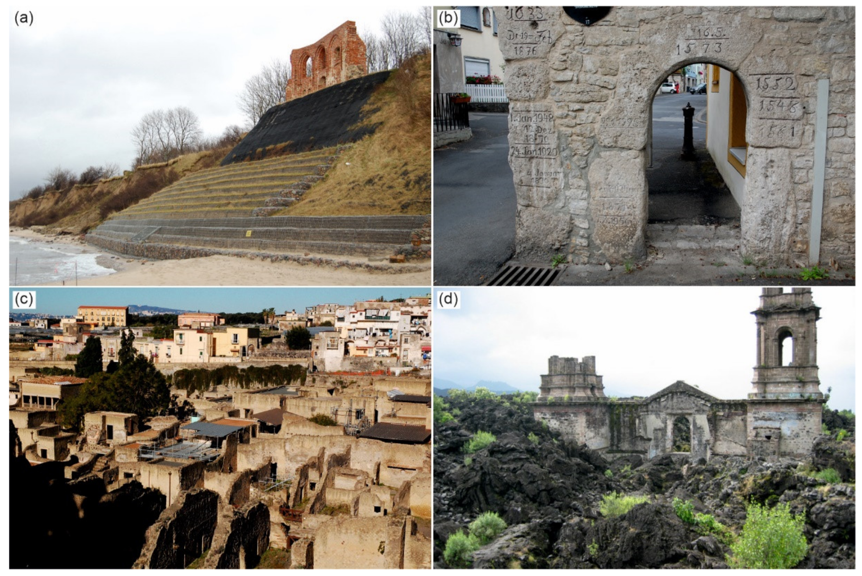
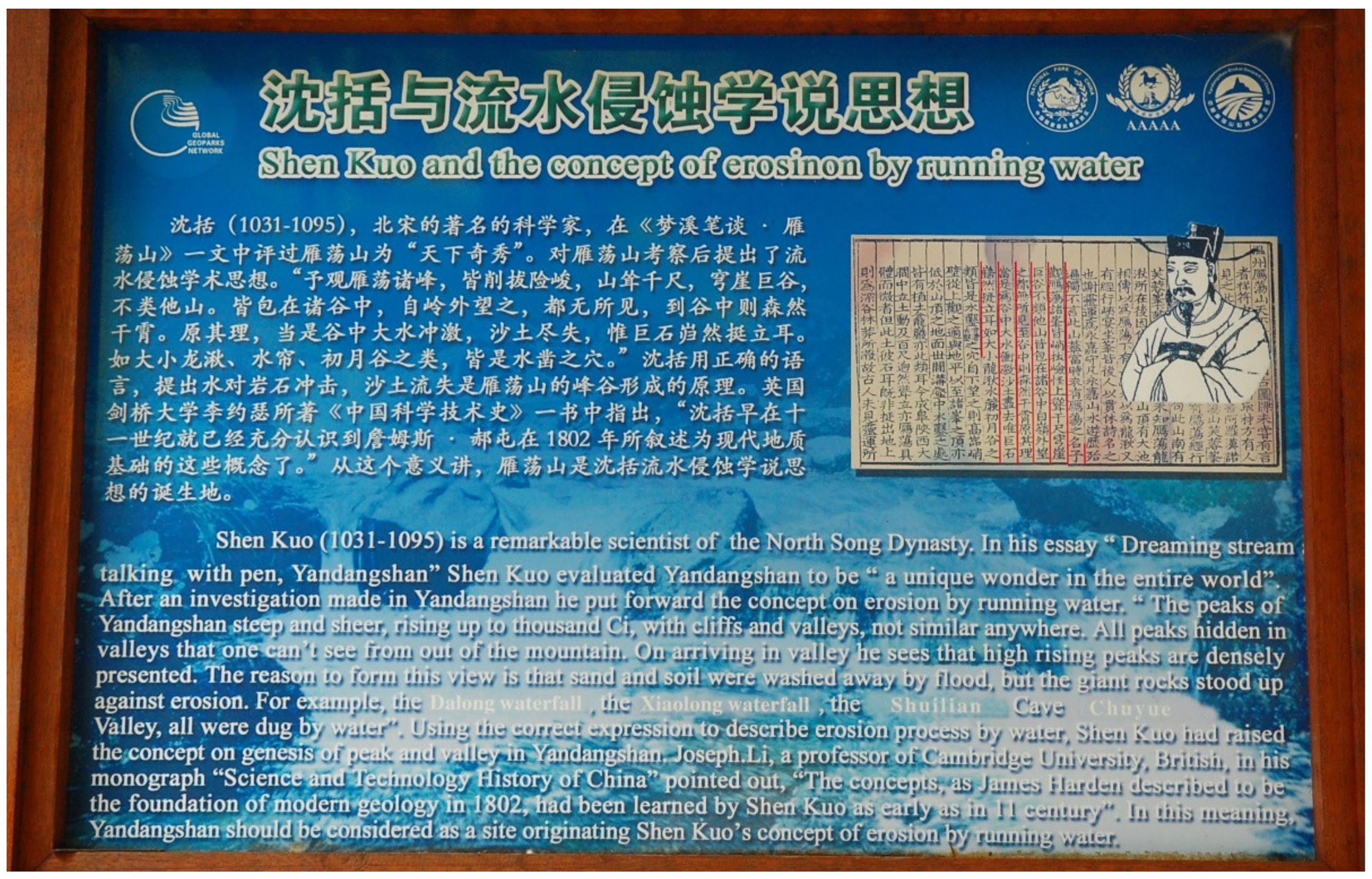
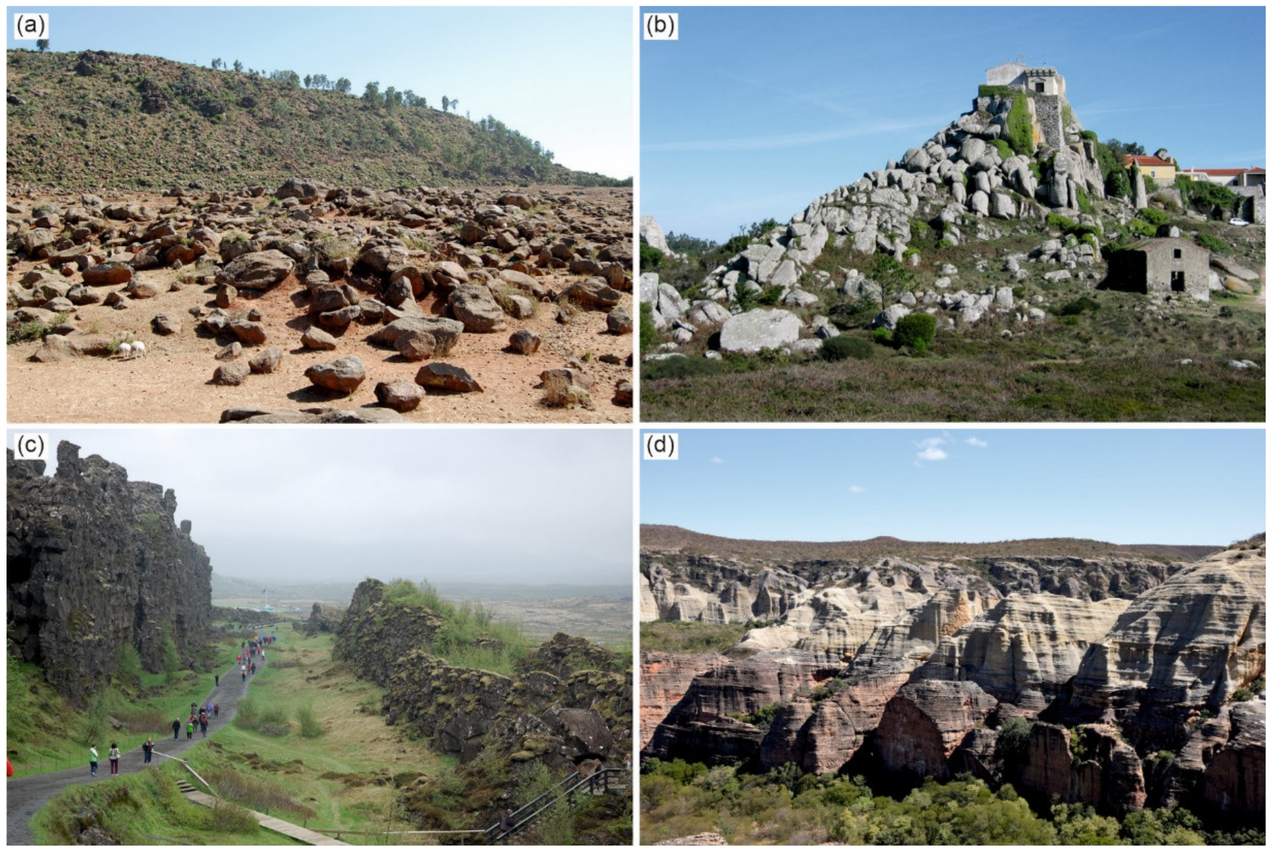

Publisher’s Note: MDPI stays neutral with regard to jurisdictional claims in published maps and institutional affiliations. |
© 2022 by the authors. Licensee MDPI, Basel, Switzerland. This article is an open access article distributed under the terms and conditions of the Creative Commons Attribution (CC BY) license (https://creativecommons.org/licenses/by/4.0/).