A New Approach for Structural Monitoring of Large Dams with a Three-Dimensional Laser Scanner


Abstract
:1. Introduction
- Classical topographic methods based on angles, distances and height variation measurementsare very popular in the quantitative surveying field. The equipment used consists of accurateand appropriate theodolites or total stations. When the point that has to be determined isinaccessible, indirect methods are used, for example: single or multiple intersections [9].Furthermore, contact sensors can complete these measurements, such as: an inclinometer, apendulum, dial gauges or extensometers. However, this contact nature prevents them from useat the final stages of destructive load testing, and they can only acquire measurements in onedimension.
- The Global Positioning System (GPS) has been used in structural monitoring of large dams [13, 17], [19-21], as well as combined with other sensors such as accelerometers [14] and inertialnavigation systems [12]. In spite of this, GPS has two significant limitations, as well. Firstly, assignals are received from satellites, coordinates cannot be measured indoors or throughobstacles. The second limitation is that the current precision levels of GPS are limited to +/- 1cm horizontally, and +/- 2cm vertically [3].
- Digital close-range photogrammetry has been a low cost alternative [2], and is highly accurate [8]. It also offers a quick, remote, three-dimensional data acquisition with images that provide apermanent visual recording of the test, but the compulsory use of targets might bedisadvantageous in some circumstances; especially when the access to the object is risky orwhen it is inaccessible to operators. Due to the lack of scale definition in the photogrammetricprocess, measurements must be taken by using additional instrumentation (for example, reflectorless total stations).
- Terrestrial Laser Scanning has become a new alternative to the monitoring of structuresincorporating novelty approaches [18] and computer methods [11]. Although the approachesnoted above present an accurate modelling strategy and have demonstrated their viability forstructural monitoring, none of them has been tested yet over complex structures such as largedams. In this context, [1] outlined some first results of a project aimed at monitoringdeformations of large concrete dams by terrestrial laser scanning. The reported analysis focuseson two main problems: the first one is the accuracy and the stability of georeferencing, which isfundamental to make comparisons between different multi-temporal scans; the second one isthe computation of deformation based on the acquired point-clouds. Particularly, a comparison is performed using different surfaces types, such as: resampled point cloud, mesh and polynomial surface.
2. Methodology
2.1. Field work
Sensor selection
Range data acquisition
Accuracy control
2.2. Laboratory work
RBF surface modelling
- Incorporating RBF for the surface parameterisation of a complex and large structure.
- Demonstrating that modelling unorganized range data sets and topologically complicated objects is possible.
- Introducing RBF centre reduction without loss in accuracy.
- Implementing this approach using tools developed by the authors.
- Constructing a signed-distance function.
- Fitting RBF to the resulting distance function.
- Choose a subset from the interpolation nodes xi and fit an RBF only to these.
- Evaluate the residual, εi = fi-s (xi ), at all nodes.
- If the maximum residual {|εi | } is inferior to the fitting accuracy then stop.
- Else append new centres where εi is large.
- Re-fit RBF and go to step 2.
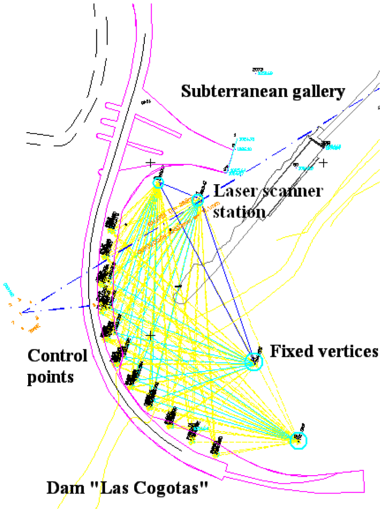
Georeferencing and accuracy control of range dataset
Structural monitoring
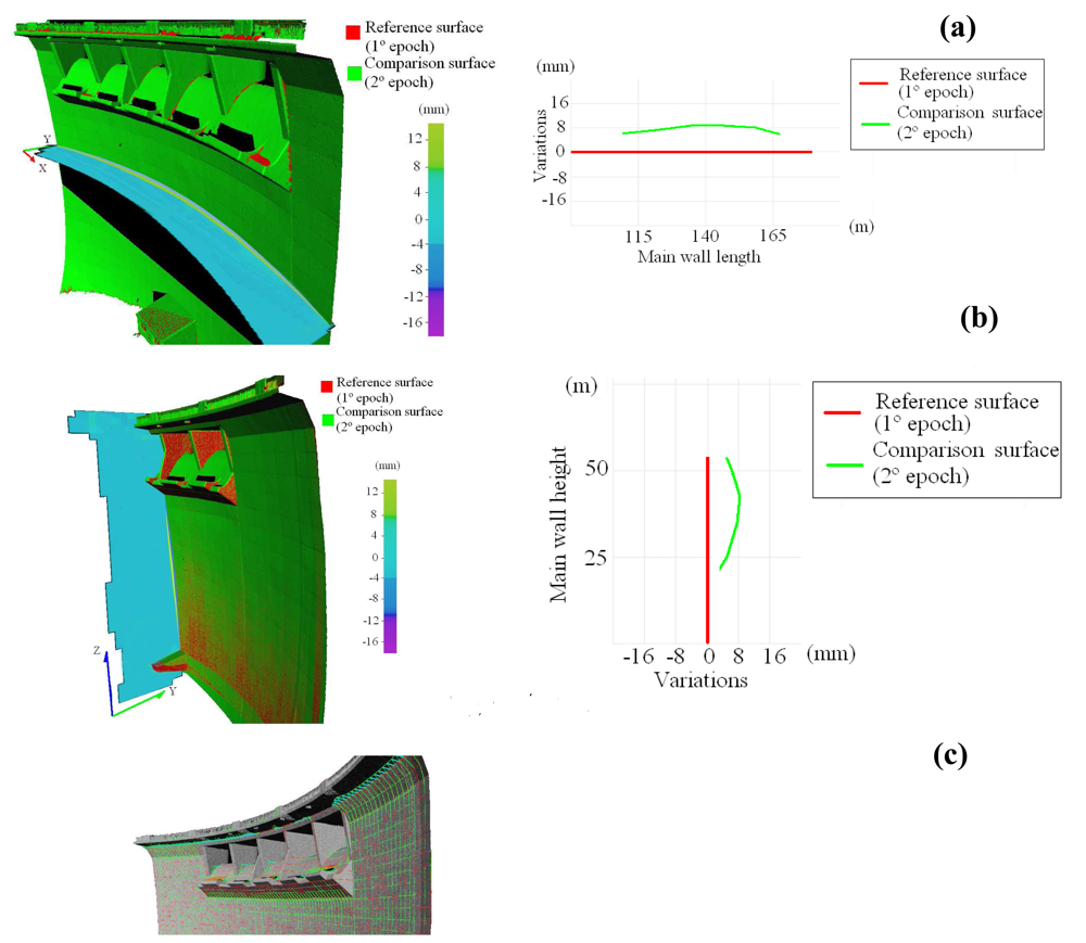
3. Experimental results: the “Las Cogotas” concrete dam
4. Analysis of Results and Conclusions
Appendix A. Radial Basis Function (RBF)
- It can be evaluated anywhere in 3D, on and off the surface, independent of the locations of theoriginal data points.
- Gradients and higher derivatives are determined analytically. They are continuous and smooth.
- The signed distance function fitted to the surface data forms a solid model.
- Interpolation and extrapolation are inherent in the functional representation. Consequently, thisapproach can be applied to the problem of mesh repair where incomplete meshes require holefilling and forming closed.
- An analytic model can be used to produce a smooth filleted join between two separate objects.
- An analytic model offers new approaches to the problems of mesh simplification, compression, morphing and reconstructing an object from scattered point cloud data.
Appendix B. Weighted Extended Orthogonal Procrustes (WEOP)
References and Notes
- Alba, M.; Fregonese, L.; Prandi, F.; Scaioni, M.; Valgoi, P. Structural monitoring of a large dam by terrestrial laser scanning. Proceedings of of the ISPRS Commission V Symposium, Dresden; 2006. [Google Scholar]
- Arias, P.; Herraez, J.; Lorenzo, H.; Ordoñez, C. Control of structural problems in cultural heritage monuments using close-range photogrammetry and computer methods. Computer Struct. 2005, 83, 1754–1766. [Google Scholar]
- Breuer, P.; Chmielewski, T.; Gorski, P.; Konopka, E. Application of GPS technology to measurements of displacements of high-rise structures due to weak winds. J. Wind Eng. Ind. Aerodyn. 2002, 90, 223–230. [Google Scholar]
- Crosilla, F. Procrustes analysis and geodetic sciences. In Quo vadis geodesia? Krumm, F., Schwarze, V.S., Eds.; Technical Reports; University of Stuttgart: Sttutgart, Germany, 1999; pp. 69–78. [Google Scholar]
- Crosilla, F.; Beinat, A. Use of generalized Procrustes analysis for the photogrammetric block adjustment by independent models. ISPRS-J. Photogramm. Remote Sens. 2002, 3, 195–209. [Google Scholar]
- Domingo, P.A. Investigación sobre los Métodos de Estimación Robusta aplicados a la resolución de los problemas fundamentales de la Fotogrametría. Doctoral Thesis., University of Cantabria, Santander, 2000. [Google Scholar]
- FIG (International Federation of Surveyors) Home Page. http://www.fig.net/ (accessed September 22, 2008).
- Fraser, C.; Riedel, B. Monitoring the thermal deformation of steel beams via vision metrology. ISPRS-J. Photogramm. Remote Sens. 2000, 55, 268–276. [Google Scholar]
- Ghilani, C.D.; Wolf, P.R. Adjustment Computations: Spatial Data Analysis, 4th edition; John Wiley & Sons: New Jersey, 2006. [Google Scholar]
- Goodall, C. Procrustes methods in the statistical analysis of shape. J. R. Stat. Soc. Ser. B-Stat. Methodol. 1991, 53, 285–339. [Google Scholar]
- Gordon, S.J.; Lichti, D.D. Modeling terrestrial laser scanner data for precise structural deformation measurement. J. Surv. Eng.-ASCE. 2007, 133, 72–80. [Google Scholar]
- Hide, C.; Blake, S.; Meng, X.; Roberts, G.; Moore, T.; Park, D. An Investigation in the use of GPS and INS Sensors for Structural Health Monitoring. Proceedings of ION GNSS, California; 2005. [Google Scholar]
- Kenneth, W.; Jeffrey, A. Continuous GPS monitoring of Structural Deformation at Pacoima Dam, California. Seismol. Res. Lett. 1998, 69, 299–308. [Google Scholar]
- Meng, X.; Roberts, G.; Dodson, A.; Andreotti, M.; Cosser, E.; Meo, M. Development of a Prototype Remote Structural Health Monitoring System (RSHMS). Proceedings of the 1st FIGInternational Symposium on Engineering Surveys for Construction Works and Structural Engineering; The University of Nottingham: Nottingham: United Kingdom, 2004. [Google Scholar]
- Leica Geosystems Home Page. Technical specifications of TCA2003. 2007. www.leicageosystems.com/common/shared/downloads/inc/downloader.asp?id=3030/ (accessed September 22, 2008).
- Lichti, D.; Gordon, J. Error Propagation in Directly Georeferenced Terrestrial Laser Scanner Point Clouds for Cultural Heritage Recording. Proceedings of FIG Working Week, Athens, Greece; 2004. [Google Scholar]
- Lovse, J.; Teskey, W.; Lachapelle, G.; Cannon, M. Dynamic deformation monitoring of tall structure using GPS technology. J. Surv. Eng.-ASCE. 1995, 121, 35–40. [Google Scholar]
- Park, H.S.; Lee, H.M.; Adeli, H.; Lee, I. A new approach for health monitoring of structures: terrestrial laser scanning. Comput.-Aided Civil Infrastruct. Eng. 2007, 22, 19–30. [Google Scholar]
- Roberts, G.; Brown, C.; Meng, X. Bridge Deflection Monitoring: Tracking Millimeters across the Firth of Forth. GPS World 2006, 26–31. [Google Scholar]
- Schenewerk, M.S.; Scott-Harris, R.; Stowell, J. Structural Health Monitoring Using GPS Observing the Sunshine Skyway Bridge. Bridges Mag. Online. 2006, 2, pp. 18–25. Available online: www.bridgesmagazineonline.com.
- Tamura, Y.; Matsuni, M.; Pagnini, L.; Ishibashi, R.; Yoshida, A. Measurement of wind-induced response of buildings using RTK-GPS. J. Wind Eng. Ind. Aerodyn. 2002, 90, 1783–1793. [Google Scholar]
- Trimble Home Page. Technical specifications of Trimble GX 3D. 2007. http://trl.trimble.com/docushare/dsweb/Get/Document-390416/022543-404_GX_3Dscanner_advanced_DS_0907_lr.pdf/ (accessed September 22, 2008).


| Efficiency | |
|---|---|
| Measurement range | 200 m (optimal); 350 m (maximum) |
| Standard deviation: | 1.4 mm £ 50 m; 2.5 mm at 100 m 3.6 mm at 150 m; |
| Single point accuracy: | 6.5 mm at 200 m |
| Horizontal angular accuracy (deg): | 12 mm at 100 m; 7 mm at 50 m |
| Vertical angular accuracy (deg): | 0.0012 |
| Circular level sensibility: | 0.0014 |
| Dual-axis compensator sensibility: | 8′ |
| Automatic leveling compensation | 6 |
| Spot size (beam diameter): | In real time |
| Spot size with autofocus: | 3 mm at 50 m |
| Laser spot spacing: | 0.3 mm at 5 m; 0.9 mm at 15 m; 1.5 mm at 25 m |
| 3.2 mm at 100 m | |
| System specifications | |
| Type of laser: | 532 nm. Time of flight. Green spot. |
| Class: | IEC 60825-1Clase 3R; 21 CFR-1041.10: Class 2 |
| Field of view: | 360° × 60° |
| Video camera | Digital image in real time with 5.5 × optic zoom |
| Beam deflection system | Oscillating mirror |
| 1st Period (May, 2006) Goals | 2nd Period (October, 2006) Goals | 3rd Periods (March, 2007) Goals |
|---|---|---|
| Initial state-Dam almost empty | After six months-Dam completely full | After subterranean gallery construction Dam completely empty |
|
|
|
| Network adjustment (4th iteration) | ||||
| Period | Control Points | Standard Deviation (mm) | ||
| σX | σY | σZ | ||
| May 2006 | I7 | 1.3 | 1.4 | 2.8 |
| I1 | 0.7 | 0.5 | 1.2 | |
| I4 | 2.4 | 1.8 | 3.1 | |
| I3 | 2.6 | 1.5 | 2.4 | |
| PA1 | 1.7 | 1.2 | 2.6 | |
| PA2 | 0.5 | 1.5 | 2.2 | |
| PA3 | 2.3 | 1.2 | 3.2 | |
| PA4 | 2.1 | 1.2 | 2.6 | |
| PA5 | 1.7 | 1.9 | 2.1 | |
| PA6 | 1.9 | 1.6 | 1.9 | |
| Scale factor | Rotation (Grad) | Translation (m) | RMSE(m) | ||||
|---|---|---|---|---|---|---|---|
| c | ω | φ | k | tx | ty | tz | RMSE |
| 1.0001 | 0.0324 | 0.0406 | 200.9251 | 100.902 | 5.256 | -0.216 | 0.003 |
| 3D surface parameters (1st Period) | 3D surface parameters (2sd Period) | ||||||
|---|---|---|---|---|---|---|---|
| RBF centres | N° of points | N° of triangles | RMSE | RBF centres | N° of points | N° of triangles | RMSE |
| 110296 | 4666051 | 8688803 | 0.003 | 119395 | 4984299 | 9023803 | 0.003 |
| 3D surface parameters (2sd Period) | 3D surface parameters (3rd Period) | ||||||
|---|---|---|---|---|---|---|---|
| RBF centres | N° of points | N° of triangles | RMSE | RBF centres | N° of points | N° of triangles | RMSE |
| 119395 | 4984299 | 9023803 | 0.003 | 123112 | 5236666 | 9147907 | 0.002 |
© 2008 by the authors; licensee Molecular Diversity Preservation International, Basel, Switzerland. This article is an open-access article distributed under the terms and conditions of the Creative Commons Attribution license (http://creativecommons.org/licenses/by/3.0/).
Share and Cite
González-Aguilera, D.; Gómez-Lahoz, J.; Sánchez, J. A New Approach for Structural Monitoring of Large Dams with a Three-Dimensional Laser Scanner. Sensors 2008, 8, 5866-5883. https://doi.org/10.3390/s8095866
González-Aguilera D, Gómez-Lahoz J, Sánchez J. A New Approach for Structural Monitoring of Large Dams with a Three-Dimensional Laser Scanner. Sensors. 2008; 8(9):5866-5883. https://doi.org/10.3390/s8095866
Chicago/Turabian StyleGonzález-Aguilera, Diego, Javier Gómez-Lahoz, and José Sánchez. 2008. "A New Approach for Structural Monitoring of Large Dams with a Three-Dimensional Laser Scanner" Sensors 8, no. 9: 5866-5883. https://doi.org/10.3390/s8095866
APA StyleGonzález-Aguilera, D., Gómez-Lahoz, J., & Sánchez, J. (2008). A New Approach for Structural Monitoring of Large Dams with a Three-Dimensional Laser Scanner. Sensors, 8(9), 5866-5883. https://doi.org/10.3390/s8095866