Deep Learning Meets InSAR for Infrastructure Monitoring: A Systematic Review of Models, Applications, and Challenges
Abstract
1. Introduction
2. Materials and Methods
2.1. Existing Systematic Reviews
2.2. Identified Gaps
2.3. Contribution of This Review
3. Methodology
3.1. Research Questions
3.2. Data Sources
3.3. Inclusion and Exclusion Criteria
- Articles that apply methodologies based on deep neural networks.
- Articles in which InSAR data is used directly as input for DL models, without being limited to validation, comparison or visualisation functions.
- Articles that use InSAR data or derived techniques, such as PSInSAR, SBAS or DInSAR.
- Articles addressing the monitoring of infrastructure at risk or phenomena with a potential impact on infrastructure.
- Articles that only use traditional Machine Learning techniques, without resorting to deep neural networks.
- Articles using InSAR data only for validation or visual support, but not as direct input into DL models.
- Articles that do not use InSAR data or associated techniques.
- Articles that do not monitor infrastructure or establish a relationship with infrastructure risk.
- Duplicate articles that do not contribute directly to the review topic.
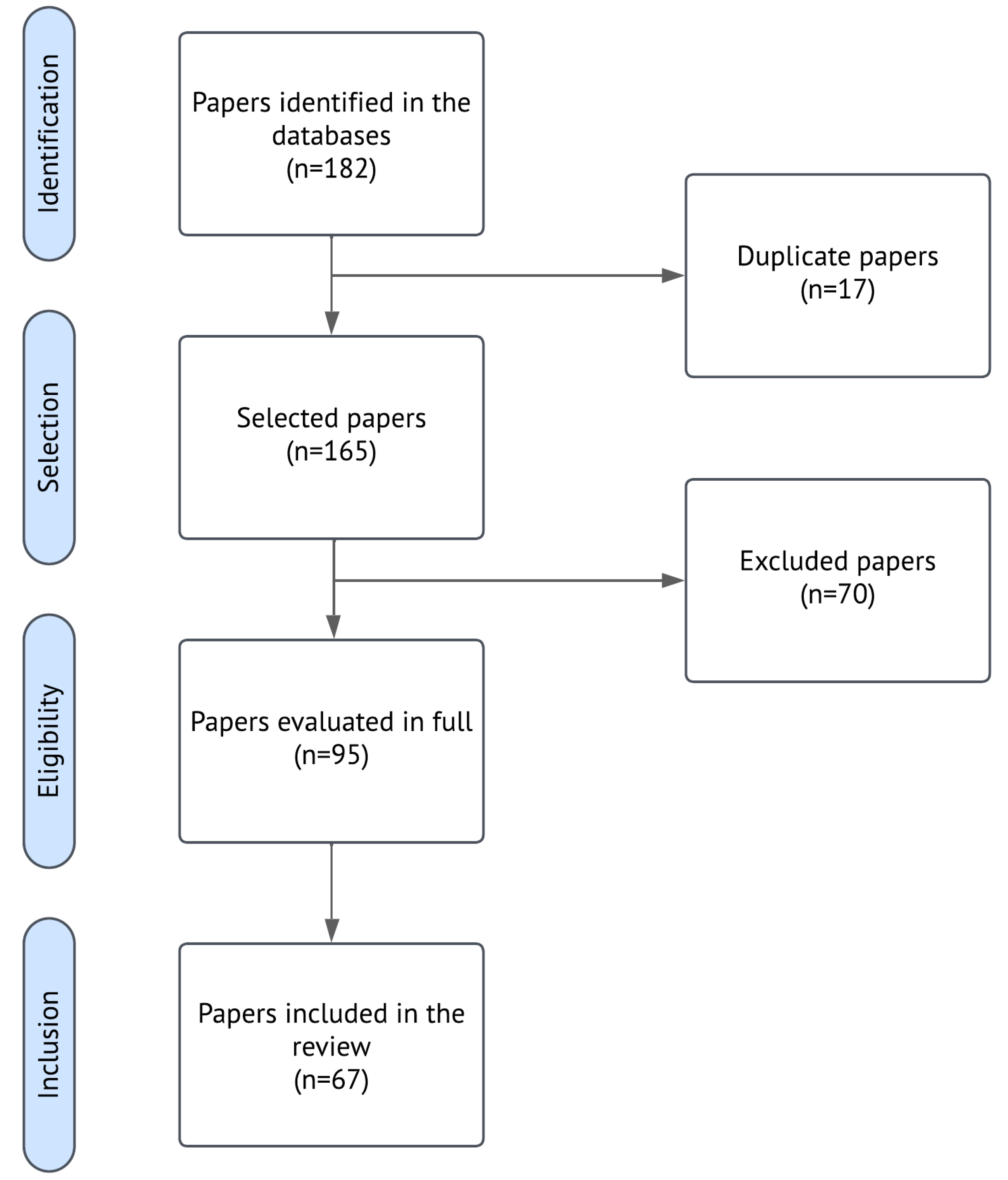
3.4. Search and Selection Strategy
- The Deep Learning domain included terms such as “deep learning”, “machine learning”, “artificial intelligence”, specific architectures like “convolutional neural network” (and “CNN”), “recurrent neural network” (and “RNN”), “LSTM”, “GRU”, and “transformer”.
- The InSAR domain covered general terms like “InSAR” and “interferometric synthetic aperture radar”, as well as specific techniques such as “PSInSAR”, “DInSAR”, and “SBAS”.
- The Infrastructure Monitoring domain encompassed keywords related to infrastructure types (“infrastructure”, “building”, “bridge”, “dam”, “railway”, “road”), monitoring practices (“structural health monitoring”, “SHM”, “infrastructure monitoring”), and relevant phenomena (“geotechnical”, “landslide”, “slope stability”).
3.5. Extraction of Study Characteristics
4. Results
4.1. DL Models Used in Infrastructure Monitoring with InSAR (RQ1)
4.1.1. Frequency and Diversity of Architectures
4.1.2. Hybrid and Emerging Architectures
4.1.3. Less Common but Noteworthy Models
4.2. DL Applications in InSAR Data Processing (RQ2)
4.3. DL Applications in Monitoring and Analysis (RQ2)
4.3.1. Time Series Modeling and Deformation Prediction
4.3.2. Spatial Segmentation and Deformation Detection
4.3.3. Risk and Susceptibility Classification
4.3.4. Multi-Stage and End-to-End Pipelines
4.4. Infrastructure Types Monitored (RQ3)
5. Discussion
5.1. Methodology Maturity and Challenges in Data Processing
5.2. Methodology Maturity and Challenges in Monitoring and Analysis
5.3. Physical Limitations and the Territorial-Structural Distinction
5.4. Emerging Trends and Future Research Opportunities
5.5. Synthesis Across Research Questions
6. Conclusions
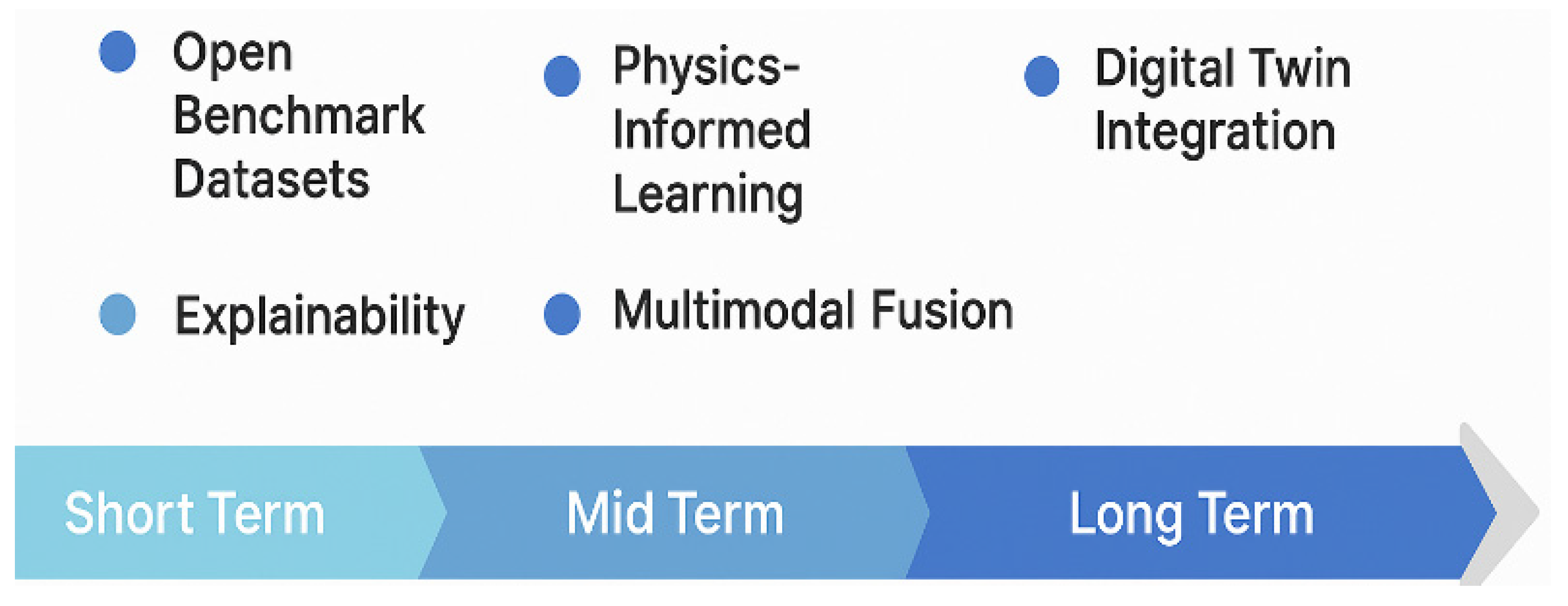
- the development of open and standardized benchmark datasets,
- the adoption of explainable AI frameworks tailored to InSAR,
- the integration of contextual and multimodal data,
- the design of end-to-end architectures with operational capacity,
- the incorporation of physics-informed constraints, and
- the alignment of DL models with digital twin environments and early warning systems.
Author Contributions
Funding
Data Availability Statement
Acknowledgments
Conflicts of Interest
References
- Le, N.D.; Tran, D.; Harper, C.M.; Sturgill, R.E. Exploring Inspection Technologies for Highway Infrastructure During Construction and Asset Management. Transp. Res. Rec. 2024, 2679, 123–135. [Google Scholar] [CrossRef]
- Scaioni, M.; Marsella, M.; Crosetto, M.; Tornatore, V.; Wang, J. Geodetic and Remote-Sensing Sensors for Dam Deformation Monitoring. Sensors 2018, 18, 3682. [Google Scholar] [CrossRef]
- Zinno, R.; Haghshenas, S.S.; Guido, G.; Vitale, A. Artificial Intelligence and Structural Health Monitoring of Bridges: A Review of the State-of-the-Art. IEEE Access 2022, 10, 88058–88078. [Google Scholar] [CrossRef]
- Ranyal, E.; Sadhu, A.; Jain, K. Road Condition Monitoring Using Smart Sensing and Artificial Intelligence: A Review. Sensors 2022, 22, 3044. [Google Scholar] [CrossRef] [PubMed]
- Shin, H.; Kim, J.; Kim, K.; Lee, S. Empirical Case Study on Applying Artificial Intelligence and Unmanned Aerial Vehicles for the Efficient Visual Inspection of Residential Buildings. Buildings 2023, 13, 2754. [Google Scholar] [CrossRef]
- Volpert, S.; Eichhammer, P.; Held, F.; Huffert, T.; Reiser, H.P.; Domaschka, J. The view on systems monitoring and its requirements from future Cloud-to-Thing applications and infrastructures. Future Gener. Comput. Syst. 2023, 141, 243–257. [Google Scholar] [CrossRef]
- D’Aranno, P.; Di Benedetto, A.; Fiani, M.; Marsella, M. Remote sensing technologies for linear infrastructure monitoring. Int. Arch. Photogramm. Remote Sens. Spat. Inf. Sci. 2019, XLII-2-W11, 461–468. [Google Scholar] [CrossRef]
- Stramondo, S.; Bignami, C.; Pierdicca, N.; Chini, M. SAR and optical remote sensing for urban damage detection and mapping: Case studies. In Proceedings of the 2007 Urban Remote Sensing Joint Event, Paris, France, 11–13 April 2007; pp. 1–6. [Google Scholar]
- Biondi, F.; Addabbo, P.; Ullo, S.L.; Clemente, C.; Orlando, D. Perspectives on the Structural Health Monitoring of Bridges by Synthetic Aperture Radar. Remote Sens. 2020, 12, 3852. [Google Scholar] [CrossRef]
- Ozden, A.; Faghri, A.; Li, M.; Tabrizi, K. Evaluation of Synthetic Aperture Radar Satellite Remote Sensing for Pavement and Infrastructure Monitoring. Procedia Eng. 2016, 145, 752–759. [Google Scholar] [CrossRef]
- Mohammed, O.I.; Saeidi, V.; Pradhan, B.; Yusuf, Y.A. Advanced differential interferometry synthetic aperture radar techniques for deformation monitoring: A review on sensors and recent research development. Geocarto Int. 2014, 29, 536–553. [Google Scholar] [CrossRef]
- Milillo, P.; Giardina, G.; DeJong, M.J.; Perissin, D.; Milillo, G. Multi-Temporal InSAR Structural Damage Assessment: The London Crossrail Case Study. Remote Sens. 2018, 10, 287. [Google Scholar] [CrossRef]
- Bekaert, D.P.S.; Walters, R.J.; Wright, T.J.; Hooper, A.J.; Parker, D.J. Statistical comparison of InSAR tropospheric correction techniques. Remote Sens. Environ. 2015, 170, 40–47. [Google Scholar] [CrossRef]
- Ding, X.; Li, Z.; Zhu, J.; Feng, G.; Long, J. Atmospheric Effects on InSAR Measurements and Their Mitigation. Sensors 2008, 8, 5426–5448. [Google Scholar] [CrossRef] [PubMed]
- Sikdar, A.; Udupa, S.; Sundaram, S.; Sundararajan, N. Fully Complex-valued Fully Convolutional Multi-feature Fusion Network(FC2MFN) for Building Segmentation of InSAR images. In Proceedings of the 2022 IEEE Symposium Series on Computational Intelligence (SSCI), Singapore, 4–7 December 2022; pp. 581–587. [Google Scholar]
- Silva, B.; Sousa, J.J.; Lazecky, M.; Cunha, A. Deformation Fringes Detection in SAR interferograms Using Deep Learning. Procedia Comput. Sci. 2022, 196, 151–158. [Google Scholar] [CrossRef]
- Li, X.; Chen, T. Landslide Recognition Based on CNN and Transformer Feature Fusion. In Proceedings of the IGARSS 2024—2024 IEEE International Geoscience and Remote Sensing Symposium, Athens, Greece, 7–12 July 2024; pp. 8246–8249. [Google Scholar]
- Dakhore, K.U.; Kalasakar, A.D. Nationwide Landslide Prediction in India Using Neural Networks and Multi-Source Satellite Data. IJFMR—Int. J. Multidiscip. Res. 2024, 6, 31933. [Google Scholar] [CrossRef]
- Martin, G.; Selvakumaran, S.; Marinoni, A.; Sadeghi, Z.; Middleton, C. Structural Health Monitoring on Urban Areas by Using Multi Temporal Insar and Deep Learning. In Proceedings of the 2021 IEEE International Geoscience and Remote Sensing Symposium IGARSS, Brussels, Belgium, 11–16 July 2021; pp. 176–179. [Google Scholar]
- Zhu, X.X.; Montazeri, S.; Ali, M.; Hua, Y.; Wang, Y.; Mou, L.; Shi, Y.; Xu, F.; Bamler, R. Deep Learning Meets SAR: Concepts, models, pitfalls, and perspectives. IEEE Geosci. Remote Sens. Mag. 2021, 9, 143–172. [Google Scholar] [CrossRef]
- Imad, H.; Sara, Z.; Hajji, M.; Yassine, T.; Abdelkrim, N. Recent Advances in SAR Image Analysis Using Deep Learning Approaches: Examples of Speckle Denoising and Change Detection. In Proceedings of the 2024 4th International Conference on Innovative Research in Applied Science, Engineering and Technology (IRASET), Fez, Morocco, 16–17 May 2024; pp. 1–6. [Google Scholar]
- Ma, Z.; Mei, G. Deep learning for geological hazards analysis: Data, models, applications, and opportunities. Earth-Sci. Rev. 2021, 223, 103858. [Google Scholar] [CrossRef]
- Li, Z.; Duan, M.; Cao, Y.; Mu, M.; He, X.; Wei, J. Mitigation of time-series InSAR turbulent atmospheric phase noise: A review. Geod. Geodyn. 2022, 13, 93–103. [Google Scholar] [CrossRef]
- Zhou, L.; Yu, H.; Lan, Y.; Xing, M. Artificial Intelligence In Interferometric Synthetic Aperture Radar Phase Unwrapping: A Review. IEEE Geosci. Remote Sens. Mag. 2021, 9, 10–28. [Google Scholar] [CrossRef]
- Farooq, B.; Manocha, A. Satellite-based change detection in multi-objective scenarios: A comprehensive review. Remote Sens. Appl. Soc. Environ. 2024, 34, 101168. [Google Scholar] [CrossRef]
- He, R.; Zhang, W.; Dou, J.; Jiang, N.; Xiao, H.; Zhou, J. Application of artificial intelligence in three aspects of landslide risk assessment: A comprehensive review. Rock Mech. Bull. 2024, 3, 100144. [Google Scholar] [CrossRef]
- Oveis, A.H.; Giusti, E.; Ghio, S.; Martorella, M. A Survey on the Applications of Convolutional Neural Networks for Synthetic Aperture Radar: Recent Advances. IEEE Aerosp. Electron. Syst. Mag. 2022, 37, 18–42. [Google Scholar] [CrossRef]
- Han, J.; Yang, H.; Liu, Y.; Lu, Z.; Zeng, K.; Jiao, R. A Deep Learning Application for Deformation Prediction from Ground-Based InSAR. Remote Sens. 2022, 14, 5067. [Google Scholar] [CrossRef]
- Lattari, F.; Rucci, A.; Matteucci, M. A Deep Learning Approach for Change Points Detection in InSAR Time Series. IEEE Trans. Geosci. Remote Sens. 2022, 60, 1–16. [Google Scholar] [CrossRef]
- Wang, T.; Zhang, Q.; Wu, Z. A Deep-Learning-Facilitated, Detection-First Strategy for Operationally Monitoring Localized Deformation with Large-Scale InSAR. Remote Sens. 2023, 15, 2310. [Google Scholar] [CrossRef]
- Yazbeck, J.; Rundle, J.B. A Fusion of Geothermal and InSAR Data with Machine Learning for Enhanced Deformation Forecasting at the Geysers. Land 2023, 12, 1977. [Google Scholar] [CrossRef]
- Yuan, R.; Chen, J. A hybrid deep learning method for landslide susceptibility analysis with the application of InSAR data. Nat. Hazards 2022, 114, 1393–1426. [Google Scholar] [CrossRef]
- Meghanadh, D.; Kumar Maurya, V.; Tiwari, A.; Dwivedi, R. A multi-criteria landslide susceptibility mapping using deep multi-layer perceptron network: A case study of Srinagar-Rudraprayag region (India). Adv. Space Res. 2022, 69, 1883–1893. [Google Scholar] [CrossRef]
- Zhang, T.; Zhang, W.; Cao, D.; Yi, Y.; Wu, X. A New Deep Learning Neural Network Model for the Identification of InSAR Anomalous Deformation Areas. Remote Sens. 2022, 14, 2690. [Google Scholar] [CrossRef]
- Montisci, A.; Porcu, M.C. A Satellite Data Mining Approach Based on Self-Organized Maps for the Early Warning of Ground Settlements in Urban Areas. Appl. Sci. 2022, 12, 2679. [Google Scholar] [CrossRef]
- Wu, Q.; Ge, D.; Yu, J.; Zhang, L.; Ma, Y.; Chen, Y.; Wan, X.; Wang, Y.; Zhang, L. Active Deformation Areas of Potential Landslide Mapping with a Generalized Convolutional Neural Network. Remote Sens. 2024, 16, 1090. [Google Scholar] [CrossRef]
- Xu, M.; Zhang, D.; Li, J.; Wu, Y. An adaptive spatial–temporal prediction model for landslide displacement based on decomposition architecture. Eng. Appl. Artif. Intell. 2024, 137, 109215. [Google Scholar] [CrossRef]
- Chen, X.; Zhao, C.; Liu, X.; Zhang, S.; Xi, J.; Khan, B.A. An Embedding Swin Transformer Model for Automatic Slow-Moving Landslide Detection Based on InSAR Products. IEEE Trans. Geosci. Remote Sens. 2024, 62, 1–15. [Google Scholar] [CrossRef]
- He, Y.; Zhao, Z.; Zhu, Q.; Liu, T.; Zhang, Q.; Yang, W.; Zhang, L.; Wang, Q. An integrated neural network method for landslide susceptibility assessment based on time-series InSAR deformation dynamic features. Int. J. Digit. Earth 2024, 17, 2295408. [Google Scholar] [CrossRef]
- Zhou, C.; Ye, M.; Xia, Z.; Wang, W.; Luo, C.; Muller, J.-P. An interpretable attention-based deep learning method for landslide prediction based on multi-temporal InSAR time series: A case study of Xinpu landslide in the TGRA. Remote Sens. Environ. 2025, 318, 114580. [Google Scholar] [CrossRef]
- Kuzu, R.S.; Bagaglini, L.; Wang, Y.; Dumitru, C.O.; Braham, N.A.A.; Pasquali, G.; Santarelli, F.; Trillo, F.; Saha, S.; Zhu, X.X. Automatic Detection of Building Displacements Through Unsupervised Learning From InSAR Data. IEEE J. Sel. Top. Appl. Earth Obs. Remote Sens. 2023, 16, 6931–6947. [Google Scholar] [CrossRef]
- Sun, Q.; Li, C.; Xiong, T.; Gui, R.; Han, B.; Tan, Y.; Guo, A.; Li, J.; Hu, J. Automatic Landslide Detection in Gansu, China, Based on InSAR Phase Gradient Stacking and AttU-Net. Remote Sens. 2024, 16, 3711. [Google Scholar] [CrossRef]
- Zhang, Y.; Li, Y.; Meng, X.; Liu, W.; Wang, A.; Liang, Y.; Su, X.; Zeng, R.; Chen, X. Automatic Mapping of Potential Landslides Using Satellite Multitemporal Interferometry. Remote Sens. 2023, 15, 4951. [Google Scholar] [CrossRef]
- Wang, X.; Chen, W.; Ren, H.; Guo, H. Automatic recognition of active landslides by surface deformation and deep learning. Prog. Phys. Geogr. 2024, 48, 671–697. [Google Scholar] [CrossRef]
- Cai, J.; Ming, D.; Liu, F.; Ling, X.; Liu, N.; Zhang, L.; Xu, L.; Li, Y.; Zhu, M. Change detection of slow-moving landslide with multi-source SBAS-InSAR and Light-U2Net. Int. J. Appl. Earth Obs. Geoinf. 2025, 136, 104387. [Google Scholar] [CrossRef]
- Malinowska, D.; Milillo, P.; Briggs, K.; Reale, C.; Giardina, G. Coherence-Based Prediction of Multi-Temporal InSAR Measurement Availability for Infrastructure Monitoring. IEEE J. Sel. Top. Appl. Earth Obs. Remote Sens. 2024, 17, 16392–16410. [Google Scholar] [CrossRef]
- Lu, J.; Wang, Y.; Zhu, Y.; Liu, J.; Xu, Y.; Yang, H.; Wang, Y. DACLnet: A Dual-Attention-Mechanism CNN-LSTM Network for the Accurate Prediction of Nonlinear InSAR Deformation. Remote Sens. 2024, 16, 2474. [Google Scholar] [CrossRef]
- Hussain, M.A.; Chen, Z.; Zheng, Y.; Zhou, Y.; Daud, H. Deep Learning and Machine Learning Models for Landslide Susceptibility Mapping with Remote Sensing Data. Remote Sens. 2023, 15, 4703. [Google Scholar] [CrossRef]
- Li, Z.; Shi, A.; Li, X.; Dou, J.; Li, S.; Chen, T.; Chen, T. Deep Learning-Based Landslide Recognition Incorporating Deformation Characteristics. Remote Sens. 2024, 16, 992. [Google Scholar] [CrossRef]
- Wang, Y.; Li, S.; Li, B. Deformation Prediction of Cihaxia Landslide Using InSAR and Deep Learning. Water 2022, 14, 3990. [Google Scholar] [CrossRef]
- Zhao, G.-H.; Lan, H.-X.; Yin, H.-Y.; Li, L.-P.; Strom, A.; Sun, W.-F.; Tian, C.-Y. Deformation, structure and potential hazard of a landslide based on InSAR in Banbar county, Xizang (Tibet). China Geol. 2024, 7, 203–221. [Google Scholar] [CrossRef]
- Anantrasirichai, N.; Biggs, J.; Kelevitz, K.; Sadeghi, Z.; Wright, T.; Thompson, J.; Achim, A.M.; Bull, D. Detecting Ground Deformation in the Built Environment Using Sparse Satellite InSAR Data with a Convolutional Neural Network. IEEE Trans. Geosci. Remote Sens. 2021, 59, 2940–2950. [Google Scholar] [CrossRef]
- Fu, L.; Zhang, Q.; Wang, T.; Li, W.; Xu, Q.; Ge, D. Detecting slow-moving landslides using InSAR phase-gradient stacking and deep-learning network. Front. Environ. Sci. 2022, 10, 963322. [Google Scholar] [CrossRef]
- Entezami, A.; De Michele, C.; Arslan, A.N.; Behkamal, B. Detection of Partially Structural Collapse Using Long-Term Small Displacement Data from Satellite Images. Sensors 2022, 22, 4964. [Google Scholar] [CrossRef]
- Pięk, M.; Pawłuszek-Filipiak, K. Displacement time series forecasting and anomaly detection based on EGMS-PSInSAR data towards effective bridge monitoring. Remote Sens. Appl. Soc. Environ. 2025, 37, 101433. [Google Scholar] [CrossRef]
- Li, Z.; Chen, J.; Cao, C.; Zhang, W.; Zhu, K.; Bai, J.; Wu, C. Enhancing long-term prediction of non-homogeneous landslides incorporating spatiotemporal graph convolutional networks and InSAR. Eng. Geol. 2025, 347, 107917. [Google Scholar] [CrossRef]
- Bayaraa, M.; Rossi, C.; Kalaitzis, F.; Sheil, B. Entity Embeddings in Remote Sensing: Application to Deformation Monitoring for Infrastructure. Remote Sens. 2023, 15, 4910. [Google Scholar] [CrossRef]
- Zhou, P.; Liu, W.; Zhang, X.; Wang, J. Evaluating Permafrost Degradation in the Tuotuo River Basin by MT-InSAR and LSTM Methods. Sensors 2023, 23, 1215. [Google Scholar] [CrossRef]
- Kovačević, M.S.; Bačić, M.; Librić, L.; Gavin, K. Evaluation of Creep Behavior of Soft Soils by Utilizing Multisensor Data Combined with Machine Learning. Sensors 2022, 22, 2888. [Google Scholar] [CrossRef]
- Wang, S.; Zhuang, J.; Mu, J.; Zheng, J.; Zhan, J.; Wang, J.; Fu, Y. Evaluation of landslide susceptibility of the Ya’an–Linzhi section of the Sichuan–Tibet Railway based on deep learning. Environ. Earth Sci. 2022, 81, 250. [Google Scholar] [CrossRef]
- Liu, Y.; Xu, P.; Cao, C.; Zhang, W.; Zhao, M.; Zhu, K. Geomorphological transformations and future deformation estimations of a large potential landslide in the high-order position area of Diexi, China. Geocarto Int. 2023, 38, 2197514. [Google Scholar] [CrossRef]
- Huo, T.; He, Y.; Zhang, L.; Yang, W.; Tang, J.; Zhang, Q.; Lu, J.; Zhang, Y. GLER-BiGRUnet: A Surface Deformation Prediction Model Fusing Multiscale Features of InSAR Deformation Information and Environmental Factors. IEEE J. Sel. Top. Appl. Earth Obs. Remote Sens. 2024, 17, 14848–14861. [Google Scholar] [CrossRef]
- Tao, Q.; Xiao, Y.; Hu, L.; Liu, R.; Li, X. Ground subsidence prediction with high precision: A novel spatiotemporal prediction model with Interferometric Synthetic Aperture Radar technology. Int. J. Remote Sens. 2024, 45, 8649–8671. [Google Scholar] [CrossRef]
- Zhou, H.; Dai, K.; Pirasteh, S.; Li, R.; Xiang, J.; Li, Z. InSAR Spatial-Heterogeneity Tropospheric Delay Correction in Steep Mountainous Areas Based on Deep Learning for Landslides Monitoring. IEEE Trans. Geosci. Remote Sens. 2023, 61, 1–14. [Google Scholar] [CrossRef]
- Ma, R.; Yu, H.; Liu, X.; Yuan, X.; Geng, T.; Li, P. InSAR-YOLOv8 for wide-area landslide detection in InSAR measurements. Sci. Rep. 2025, 15, 1595. [Google Scholar] [CrossRef]
- Giffard-Roisin, S.; Boudaour, S.; Doin, M.-P.; Yan, Y.; Atto, A. Land cover classification of the Alps from InSAR temporal coherence matrices. Front. Remote Sens. 2022, 3, 932491. [Google Scholar] [CrossRef]
- Li, J.; Fan, C.; Zhao, K.; Zhang, Z.; Duan, P. Landslide displacement prediction using time series InSAR with combined LSTM and TCN: Application to the Xiao Andong landslide, Yunnan Province, China. Nat. Hazards 2024, 121, 3857–3884. [Google Scholar] [CrossRef]
- Zhang, Y.; Chen, Y.; Ming, D.; Zhu, Y.; Ling, X.; Zhang, X.; Lian, X. Landslide hazard analysis based on SBAS-InSAR and MCE-CNN model: A case study of Kongtong, Pingliang. Geocarto Int. 2022, 38, 1–22. [Google Scholar] [CrossRef]
- Guo, J.; Xi, W.; Yang, Z.; Shi, Z.; Huang, G.; Yang, Z.; Yang, D. Landslide hazard susceptibility evaluation based on SBAS-InSAR technology and SSA-BP neural network algorithm: A case study of Baihetan Reservoir Area. J. Mt. Sci. 2024, 21, 594–614. [Google Scholar] [CrossRef]
- Li, S.; Yin, C.; Li, J.; Sun, T. Landslide susceptibility assessment based on remote sensing interpretation and DBN-MLP model: A case study of Yiyuan County, China. Stoch. Environ. Res. Risk Assess. 2025, 39, 493–508. [Google Scholar] [CrossRef]
- Chen, L.; Ma, P.; Yu, C.; Zheng, Y.; Zhu, Q.; Ding, Y. Landslide susceptibility assessment in multiple urban slope settings with a landslide inventory augmented by InSAR techniques. Eng. Geol. 2023, 327, 107342. [Google Scholar] [CrossRef]
- Deng, Y.; Zuo, X.; Li, Y.; Zhou, X. Landslide Susceptibility Evaluation of Bayesian Optimized CNN Gengma Seismic Zone Considering InSAR Deformation. Appl. Sci. 2023, 13, 11388. [Google Scholar] [CrossRef]
- Wang, Z.; Zhu, J.; Ma, T. Mapping of highway slope hazard susceptibility based on InSAR and machine learning: A pilot study toward road infrastructure resilience. Road Mater. Pavement Des. 2024, 26, 1974–1999. [Google Scholar] [CrossRef]
- Zhang, R.; Zhu, W.; Fan, B.; He, Q.; Zhan, J.; Wang, C.; Zhang, B. MB-Net: A network for accurately identifying creeping landslides from wrapped interferograms. Int. J. Appl. Earth Obs. Geoinf. 2024, 135, 104300. [Google Scholar] [CrossRef]
- Guo, A.; Sun, Q.; Hu, J.; Zheng, W.; Gui, R.; Yu, Y. MUSEnet: High Temporal-Frequency Estimation of Landslide Deformation Field Through Joint InSAR and Hydrological Observations Using Deep Learning. IEEE J. Sel. Top. Appl. Earth Obs. Remote Sens. 2024, 17, 1485–1499. [Google Scholar] [CrossRef]
- Milillo, P.; Sacco, G.; Di Martire, D.; Hua, H. Neural Network Pattern Recognition Experiments Toward a Fully Automatic Detection of Anomalies in InSAR Time Series of Surface Deformation. Front. Earth Sci. 2022, 9, 728643. [Google Scholar] [CrossRef]
- Yazbeck, J.; Rundle, J.B. Predicting Short-Term Deformation in the Central Valley Using Machine Learning. Remote Sens. 2023, 15, 449. [Google Scholar] [CrossRef]
- Ma, C.; Lu, B. Prediction of the Deformation of Heritage Building Communities under the Integration of Attention Mechanisms and SBAS Technology. Electronics 2023, 12, 4724. [Google Scholar] [CrossRef]
- Li, P.; Wang, H.; Li, H.; Ni, Z.; Deng, H.; Sui, H.; Xu, G. Refined Landslide Susceptibility Mapping Considering Land Use Changes and InSAR Deformation: A Case Study of Yulin City, Guangxi. Remote Sens. 2024, 16, 3016. [Google Scholar] [CrossRef]
- Jiang, Y.; Xu, Q.; Meng, R.; Zhang, C.; Zheng, L.; Lu, Z. Remote sensing characterizing and deformation predicting of Yan’an New District’s Mountain Excavation and City Construction with dual-polarization MT-InSAR method. Int. J. Appl. Earth Obs. Geoinf. 2025, 136, 104364. [Google Scholar] [CrossRef]
- Brencher, G.; Henderson, S.T.; Shean, D.E. Removing atmospheric noise from InSAR interferograms in mountainous regions with a convolutional neural network. Comput. Geosci. 2025, 194, 105771. [Google Scholar] [CrossRef]
- Yang, J.; Kou, P.; Dong, X.; Xia, Y.; Gu, Q.; Tao, Y.; Feng, J.; Ji, Q.; Wang, W.; Avtar, R. Reservoir water level decline accelerates ground subsidence: InSAR monitoring and machine learning prediction of surface deformation in the Three Gorges Reservoir area. Front. Earth Sci. 2024, 12, 1503634. [Google Scholar] [CrossRef]
- Zhu, M.; Liu, H.; Miao, C.; Li, G.; Zhang, Y.; Zhou, Y.; Cai, J.; Yang, S.; Wang, Y.; Wang, Y.; et al. Safety assessment of the Qinghai–Tibet railway: Monitoring, analysis, and prediction. Cold Reg. Sci. Technol. 2025, 231, 104395. [Google Scholar] [CrossRef]
- Ma, P.; Wu, Z.; Zhang, Z.; Au, F.T.K. SAR-Transformer-based decomposition and geophysical interpretation of InSAR time-series deformations for the Hong Kong-Zhuhai-Macao Bridge. Remote Sens. Environ. 2024, 302, 113962. [Google Scholar] [CrossRef]
- Li, X.; Ma, P.; Xu, S.; Zhang, H.; Wang, C.; Fan, Y.; Tang, Y. Slow-Moving Landslide Hazard Assessment Using LS-Unilab Deep Learning Model with Highlighted InSAR Deformation Signal. Remote Sens. 2024, 16, 4641. [Google Scholar] [CrossRef]
- Liu, Y.; Yao, X.; Gu, Z.; Zhou, Z.; Liu, X.; Chen, X.; Wei, S. Study of the Automatic Recognition of Landslides by Using InSAR Images and the Improved Mask R-CNN Model in the Eastern Tibet Plateau. Remote Sens. 2022, 14, 3362. [Google Scholar] [CrossRef]
- Jin, B.; Yin, K.; Li, Q.; Gui, L.; Yang, T.; Zhao, B.; Guo, B.; Zeng, T.; Ma, Z. Susceptibility Analysis of Land Subsidence along the Transmission Line in the Salt Lake Area Based on Remote Sensing Interpretation. Remote Sens. 2022, 14, 3229. [Google Scholar] [CrossRef]
- Khalili, M.A.; Coda, S.; Calcaterra, D.; Di Martire, D. Synergistic use of SAR satellites with deep learning model interpolation for investigating of active landslides in Cuenca, Ecuador. Geomat. Nat. Hazards Risk 2024, 15, 2383270. [Google Scholar] [CrossRef]
- Zhou, H.; Dai, K.; Wen, N.; Xiang, J.; Li, Z. The Influence of Topography-Dependent Atmospheric Delay for the InSAR Time-Series Results and the Deep Neural Network Correction. IEEE Geosci. Remote Sens. Lett. 2024, 21, 1–5. [Google Scholar] [CrossRef]
- Li, Q.; Yao, C.; Yao, X.; Zhou, Z.; Ren, K. Time Series Prediction of Reservoir Bank Slope Deformation Based on Informer and InSAR: A Case Study of Dawanzi Landslide in the Baihetan Reservoir Area, China. Remote Sens. 2024, 16, 2688. [Google Scholar] [CrossRef]
- Zhou, H.; Dai, K.; Tang, X.; Xiang, J.; Li, R.; Wu, M.; Peng, Y.; Li, Z. Time-Series InSAR with Deep-Learning-Based Topography-Dependent Atmospheric Delay Correction for Potential Landslide Detection. Remote Sens. 2023, 15, 5287. [Google Scholar] [CrossRef]
- Hill, P.; Biggs, J.; Ponce-López, V.; Bull, D. Time-Series Prediction Approaches to Forecasting Deformation in Sentinel-1 InSAR Data. J. Geophys. Res. Solid Earth 2021, 126, e2020JB020176. [Google Scholar] [CrossRef]
- Zhang, J.; Kou, P.; Tao, Y.; Jin, Z.; Huang, Y.; Cui, J.; Liang, W.; Liu, R. Urban ground subsidence monitoring and prediction using time-series InSAR and machine learning approaches: A case study of Tianjin, China. Environ. Earth Sci. 2024, 83, 473. [Google Scholar] [CrossRef]
- He, Y.; Chen, B.; Motagh, M.; Zhu, Y.; Shao, S.; Li, J.; Zhang, B.; Kaufmann, H. Zero-shot detection for InSAR-based land displacement by the deformation-prompt-based SAM method. Int. J. Appl. Earth Obs. Geoinf. 2025, 136, 104407. [Google Scholar] [CrossRef]
- Ponzo, F.C.; Auletta, G.; Ielpo, P.; Ditommaso, R. DInSAR–SBAS satellite monitoring of infrastructures: How temperature affects the ‘Ponte della Musica’ case study. J. Civ. Struct. Health Monit. 2024, 14, 745–761. [Google Scholar] [CrossRef]

| Ref. | DL Architecture | Monitored Infrastructure | InSAR Type | Monitored Phenomenon | Input | Output | Computational Complexity |
|---|---|---|---|---|---|---|---|
| [28] | LSTM | UAB | GB-InSAR | LS | TS (Def + Ext) | Pred: Future Def. and Atmos. Delay | Time (inf): 4.73 min/scene |
| [29] | LSTM; TGLSTM | UAB | PS-InSAR | LS, SF, IM, SB | TS (Def) | Detect: Change Point Prob. | Time (inf): 15 min/630 k series |
| [30] | U-Net; YOLOv3; DnCNN | O, UAB | InSAR | LS, DM | Img (Phase + Coh + Amp) | Seg/Detect/Recon: Multistage Pipeline | Qual: ‘Detection-First’ for efficiency |
| [31] | CNN; LSTM | O | InSAR | SB | Img/TS (Def + Ext) | Pred: Future Def. Image (6-day) | Qual: Computationally efficient |
| [32] | CNN; LSTM; GRU; SRU | UAB | SBAS-InSAR | LS | FV (Factors + Def) | Class: Suscept. Map | Qual: SRU for training speed |
| [33] | DMLP; LSM | UAB | MT-InSAR | LS | FV (Factors + Def) | Class: Suscept. Map | Qual: Significant time reduction |
| [34] | Mask R-CNN | R | InSAR | LS | Img (Vel) | Seg: Instance Mask | Params: 32.18 M; FLOPS: 298.53 M |
| [35] | SOM | UAB | MT-InSAR | IM | TS (Def) | Detect: Alert Signal (Cluster-based) | Qual: Real-time big data processing |
| [36] | CNN | R | InSAR | LS | Img (Phase Rate + Def + DEM + Slope) | Seg: Binary Mask (Active Areas) | Qual: Robust and efficient method |
| [37] | Autoencoder | UAB | SBAS-InSAR | LS | TS (Def + Ext) | Pred: Future Def. | Time (train): 772 s/epoch |
| [38] | CNN; YOLOv5; Transformer | R, UAB | InSAR + DEM (SBAS) | LS | Img (Composite Feature) | Detect: Bounding Box | Qual: Efficient input feature (GRCI) |
| [39] | CNN; Bi-GRU | R, O | SBAS-InSAR | LS | TS (Def + Ext) | Class: Suscept. Probability | Time (train): ~1 h 40 min |
| [40] | CNN; Bi-GRU | UAB | MT-InSAR/SBAS | LS | TS (Def + Ext) | Pred: Future Def. | Time (inf): 8–10 min/scatterer |
| [41] | Autoencoder; LSTM | UAB | PS-InSAR | IM | TS (Def) | Class: Anomaly Type | Qual: RRCF benchmark reduces costs |
| [42] | U-Net | R, UAB | InSAR | LS | Img (Phase Gradient) | Seg: Binary Mask | Qual: Computationally efficient |
| [43] | CNN | R | InSAR | LS | FV (Factors + Def Trend) | Class: Potential Landslide (Binary) | Qual: Efficient, saves interpretation time |
| [44] | DNN | R, UAB | SBAS-InSAR | LS | FV (Factors + Def + Coords) | Class: Active Landslide (Binary) | NR |
| [45] | U-Net | DHI | SBAS-InSAR | LS | Img (Vel) | Seg: Deformation Zone Mask | FLOPS: 11.48 G; Speed (inf): 80.4 FPS |
| [46] | U-Net | UAB | MT-InSAR | DM | Img (Coh + Infra. Map) | Pred: PS Count | Time (inf): 2 s/1320 km2 |
| [47] | CNN; LSTM | UAB | IPTA | DM | TS (Def) | Pred: Future Def. | Qual: Pre-processing reduces load |
| [48] | CNN; RNN | UAB | SBAS-InSAR/PS-InSAR | LS | FV (Factors) | Class: Suscept. Map | Train Params: BS 8/64, Epochs 250/500 |
| [49] | CNN | UAB | SBAS-InSAR | LS | Img (Factors + Def + Optical) | Seg: Recognition Mask | NR |
| [50] | LSTM; ARIMA | O | InSAR | DM | TS (Def) | Pred: Future Def. | Train Params: 100 Epochs, BS 128 |
| [51] | LSTM | R, UAB | SBAS-InSAR | LS | TS (Def + Ext) | Pred: Future Def. | NR |
| [52] | CNN | RW, MQ, O, UAB | PS-InSAR | IM | Img (Vel) | Class: Prob. Map | Qual: Scalable framework |
| [53] | YOLOv3 | UAB | InSAR | LS | Img (Phase Gradient) | Detect: Bounding Box | Qual: YOLOv3 for faster inference |
| [54] | ANN | BV | InSAR | BM | TS (Def) | Detect: Anomaly Score | Qual: MSD chosen for simplicity |
| [55] | LSTM; SARIMA; Prophet | BV | PS-InSAR | BM | TS (Def + Ext) | Pred: Future Def. | Time (train): Seconds to minutes |
| [56] | GCN; GRU | UAB | SBAS-InSAR | LS | Graph (Nodes as Def points) | Pred: Future Def. (per node) | Qual: STGCN requires more resources |
| [57] | DNN | MQ | InSAR | IM | FV (Meta) | Pred: Future Def. | Qual: Simple arch. outperformed complex ones |
| [58] | LSTM | RW | MT-InSAR/SBAS | DM | TS (Def) | Pred: Future Def. | Qual: LSTM hard to parallelize |
| [59] | LSTM | O | InSAR | DM | FV (Creep Params)/TS (Def) | Pred: TS (train)/FV (final) | Qual: Overcomes slow lab tests |
| [60] | CNN; DNN | RW | InSAR Stacking | LS | FV (Factors) | Class: Suscept. Index | Time (train): DNN ~45 epochs; CNN ~1300 epochs |
| [61] | LSTM; RNN | R | SBAS-InSAR | LS | TS (Def) | Pred: Future Def. | Qual: Outperforms manual measurement |
| [62] | Bi-GRU | RW | SBAS-InSAR | DM | TS (Def + Ext) | Pred: Future Def. and Ext | Time (train): 40–55 epochs for convergence |
| [63] | U-Net | UAB | SBAS-InSAR | SB | SeqImg (Def) | Pred: Future Def. Image | Params: 4.025 M |
| [64] | CNN | UAB | InSAR | LS | FV (DEM + Coords) | Recon: Atmos. Delay Phase | NR |
| [65] | YOLO (v3/v8) | UAB | SBAS-InSAR | LS | Img (Vel) | Detect: Bounding Box | Params: 2.26 M |
| [66] | CNN | UAB | InSAR | IM | Img (Coh Matrix) | Class: Land Cover Map | Qual: SVM (comparative) is efficient |
| [67] | LSTM; TCN | UAB | InSAR | LS | TS (Def) | Pred: Future Def. | Qual: TCN for efficient processing |
| [68] | CNN | UAB | SBAS-InSAR | LS | Img (Factors + Def) | Class: Landslide Probability | Qual: MCE-CNN reduces complexity |
| [69] | BP-ANN | UAB | SBAS-InSAR | LS | FV (Factors + Def) | Class: Suscept. Index | Qual: SSA-BP converges faster |
| [70] | CNN; RF; SVM; DBN | UAB | SBAS-InSAR | LS | FV (Factors) | Class: Landslide Probability | NR |
| [71] | MLP | UAB | MT-InSAR | LS | FV (Factors + Def) | Class: Landslide Probability | Qual: Few gradient updates reduce cost |
| [72] | CNN | UAB | InSAR | LS | FV (Factors + Def) | Class: Suscept. Index | Qual: Bayesian Opt. for speed |
| [73] | ANN; CatBoost | R | SBAS-InSAR | LS | FV (Factors + Def) | Class: Hazard Suscept. Prob. | NR |
| [74] | CNN | UAB | InSAR | LS | Img (Phase + Sin(Phase) + Cos(Phase)) | Seg: Semantic Mask | Params: 72.24 M; FLOPS: 67.91 G |
| [75] | CNN | UAB | InSAR + TCP | LS | TS (Def + Ext) | Interp: High-freq. daily Def. | Qual: Upsamples from 12-day to daily |
| [76] | ANN | UAB | MT-InSAR, MG | IM | TS (Def) | Detect/Class: Velocity Anomaly | Speed (inf): 2.5 M samples/s; Time (inf): 68 s/170 M series |
| [77] | LSTM | R, BV | InSAR + GRACE-FO | SB | TS (Def) | Pred: Future Def. (6-day) | NR |
| [78] | LSTM + Attention | UAB | SBAS-InSAR | IM | TS (Def) | Pred: Future Def. | NR |
| [79] | RNN; GRU; LSTM | UAB | SBAS-InSAR | LS | FV (Factors + Def) | Class: Suscept. Map | NR |
| [80] | ConvLSTM | R, UAB | Dual-pol MT-InSAR | SB | SeqImg (Def) | Pred: Future Def. Image | Qual: Significantly improves efficiency |
| [81] | CNN | UAB | InSAR | AN | Img (Phase + DEM) | Recon: Atmos. Noise Map | Qual: Correction at native resolution |
| [82] | LSTM | R | SBAS-InSAR | SB | TS (Def) | Pred: Future Def. | NR |
| [83] | LSTM | RW | SBAS-InSAR | RWM | TS (Def) | Pred: Future Def. | NR |
| [84] | Transformer | AIW, BV | TS-InSAR | BM | TS (Def, synthetic) | Decomp: Trend and Seasonal Comp. | Qual: Reduced MAE by at least 58% |
| [85] | CNN; Transformer | UAB | SBAS-InSAR | LS | Img (Def + Coh + DEM) | Class: Hazard Level (Multi-class) | NR |
| [86] | Mask R-CNN | UAB | InSAR | LS | Img (Vel) | Seg: Instance Mask | Speed (inf): 72.3 km2/s (recognition) |
| [87] | MLP | TL | SBAS-InSAR | SB | FV (Factors) | Class: Suscept. Map | NR |
| [88] | LSTM; CNN | R, UAB | MT-InSAR | LS | TS / Img (Def) | Interp: Unified Velocity Map | Qual: RMSE decreased by >73% |
| [89] | DNN | DHI | InSAR | LS | FV (DEM + Coords + Coh) | Recon: Atmos. Delay Phase | Qual: STD of deformation reduced 71% |
| [90] | Transformer | DHI | SBAS-InSAR | LS | TS (Def + Ext) | Pred: Future Def. (Long-term) | Qual: Complexity O(L log L) |
| [91] | DNN | UAB | TS-InSAR, SBAS-InSAR | LS | FV (Phase + DEM + Coords + Coh) | Recon: Atmos. Delay Phase | Qual: STD of phase reduced ~70% |
| [92] | LSTM; Seq2Seq; SARIMA | UAB | InSAR | DM | TS (Def, uni- or multivariate) | Pred: Future Def. (1–9 months) | Qual: Performance comparison (RMSE) |
| [93] | LSTM | O | InSAR, SBAS-InSAR, PS-InSAR | SB | TS (Def) | Pred: Future Settlement | Qual: Reduced RMSE by 51% vs. RF |
| [94] | Self-Attention Model | R, UAB | TS-InSAR, SBAS-InSAR, PS-InSAR | LS | Img (Vel, with prompts) | Seg: Instance Mask (Zero-shot) | Qual: Method described as “extremely fast” |
| Research Question | Key Findings | Illustrative References |
|---|---|---|
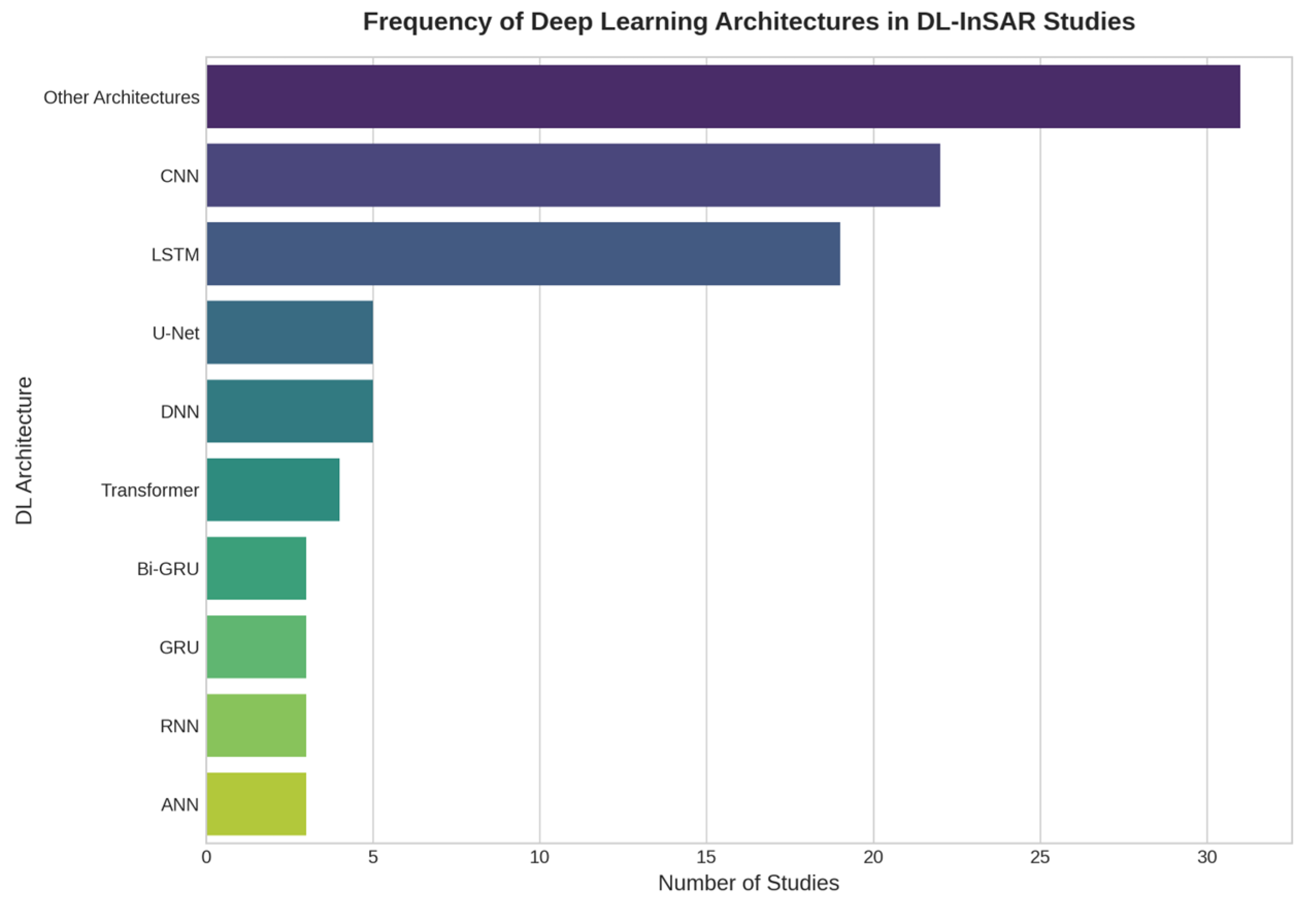
| RQ1: What DL models have been used in infrastructure monitoring with InSAR data? | LSTM and CNN are the dominant architectures, used for time-series modeling and spatial segmentation, respectively. Hybrid models (e.g., CNN-LSTM, CNN-BiGRU) are emerging but underused. Transformer and attention-based models show potential but are limited in number. | [28,31,39,40,78,84,85] |
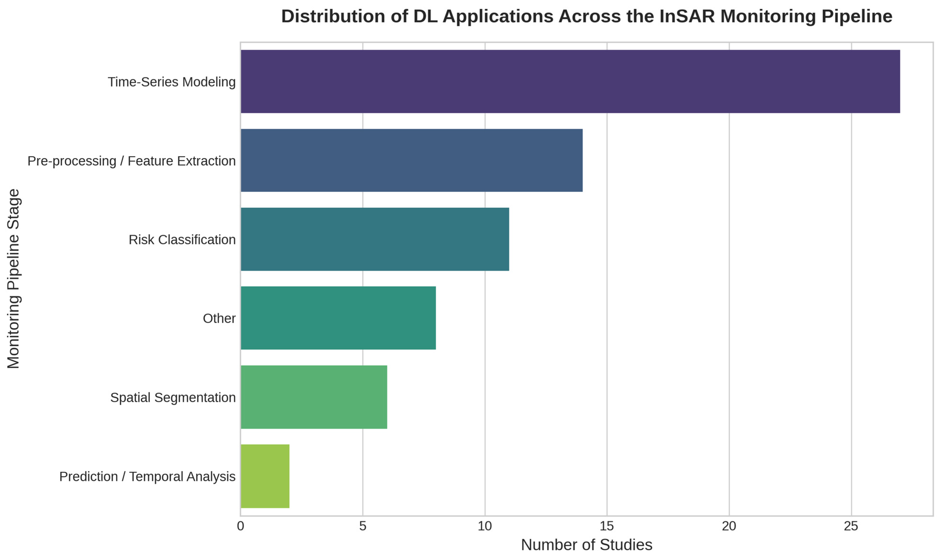
| RQ2: At what stages of the monitoring process are InSAR data integrated with DL? | DL applications are split between data processing (e.g., denoising, atmospheric correction) and analysis (e.g., prediction, segmentation). Analysis tasks, especially time-series modeling, are far more common, while critical processing steps remain under-explored and lack standardized validation. | [30,42,50,64,85] |
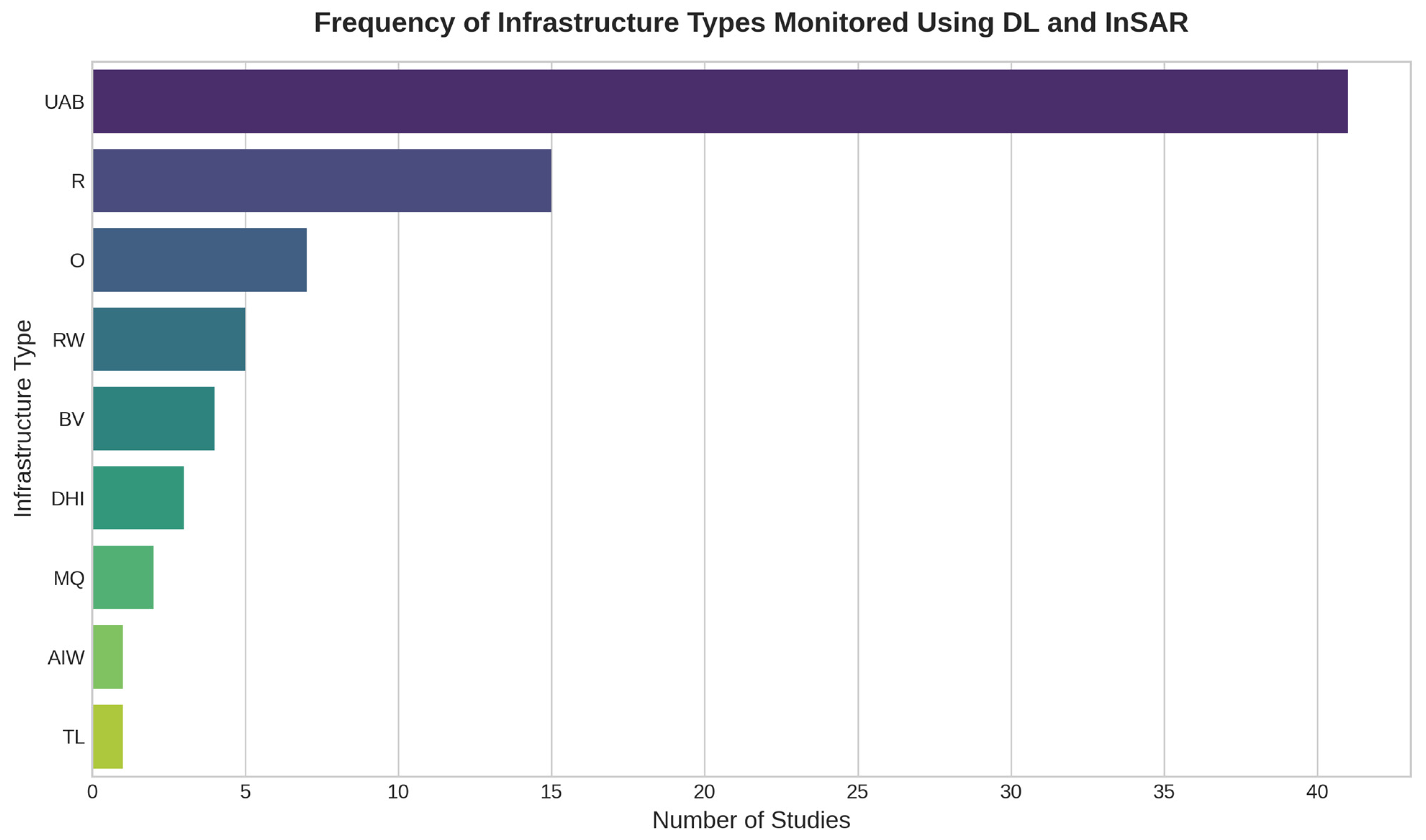
| RQ3: What types of infrastructure have been most frequently monitored? | A strong thematic imbalance exists, favoring territorial-scale applications (urban areas, landslides) over structural-scale ones (bridges, dams). This imbalance is intrinsically linked to physical InSAR limitations (e.g., thermal decorrelation exceeding limit in structural monitoring [95]), which most current DL analysis approaches fail to address, hindering generalization. | [28,36,52,54,55,90] |
Disclaimer/Publisher’s Note: The statements, opinions and data contained in all publications are solely those of the individual author(s) and contributor(s) and not of MDPI and/or the editor(s). MDPI and/or the editor(s) disclaim responsibility for any injury to people or property resulting from any ideas, methods, instructions or products referred to in the content. |
© 2025 by the authors. Licensee MDPI, Basel, Switzerland. This article is an open access article distributed under the terms and conditions of the Creative Commons Attribution (CC BY) license (https://creativecommons.org/licenses/by/4.0/).
Share and Cite
Fontes, M.; Bakoň, M.; Cunha, A.; Sousa, J.J. Deep Learning Meets InSAR for Infrastructure Monitoring: A Systematic Review of Models, Applications, and Challenges. Sensors 2025, 25, 7169. https://doi.org/10.3390/s25237169
Fontes M, Bakoň M, Cunha A, Sousa JJ. Deep Learning Meets InSAR for Infrastructure Monitoring: A Systematic Review of Models, Applications, and Challenges. Sensors. 2025; 25(23):7169. https://doi.org/10.3390/s25237169
Chicago/Turabian StyleFontes, Miguel, Matúš Bakoň, António Cunha, and Joaquim J. Sousa. 2025. "Deep Learning Meets InSAR for Infrastructure Monitoring: A Systematic Review of Models, Applications, and Challenges" Sensors 25, no. 23: 7169. https://doi.org/10.3390/s25237169
APA StyleFontes, M., Bakoň, M., Cunha, A., & Sousa, J. J. (2025). Deep Learning Meets InSAR for Infrastructure Monitoring: A Systematic Review of Models, Applications, and Challenges. Sensors, 25(23), 7169. https://doi.org/10.3390/s25237169


