Water Body Extraction Methods for SAR Images Fusing Sentinel-1 Dual-Polarized Water Index and Random Forest
Abstract
1. Introduction
2. Water Body Extraction Method
2.1. Sentinel-1 Dual-Polarized Water Index
2.2. Random Forest Algorithm
2.3. SDWI and RF Fusion Method
3. Research Area and Data Sources
3.1. Research Area
3.2. Data Sources
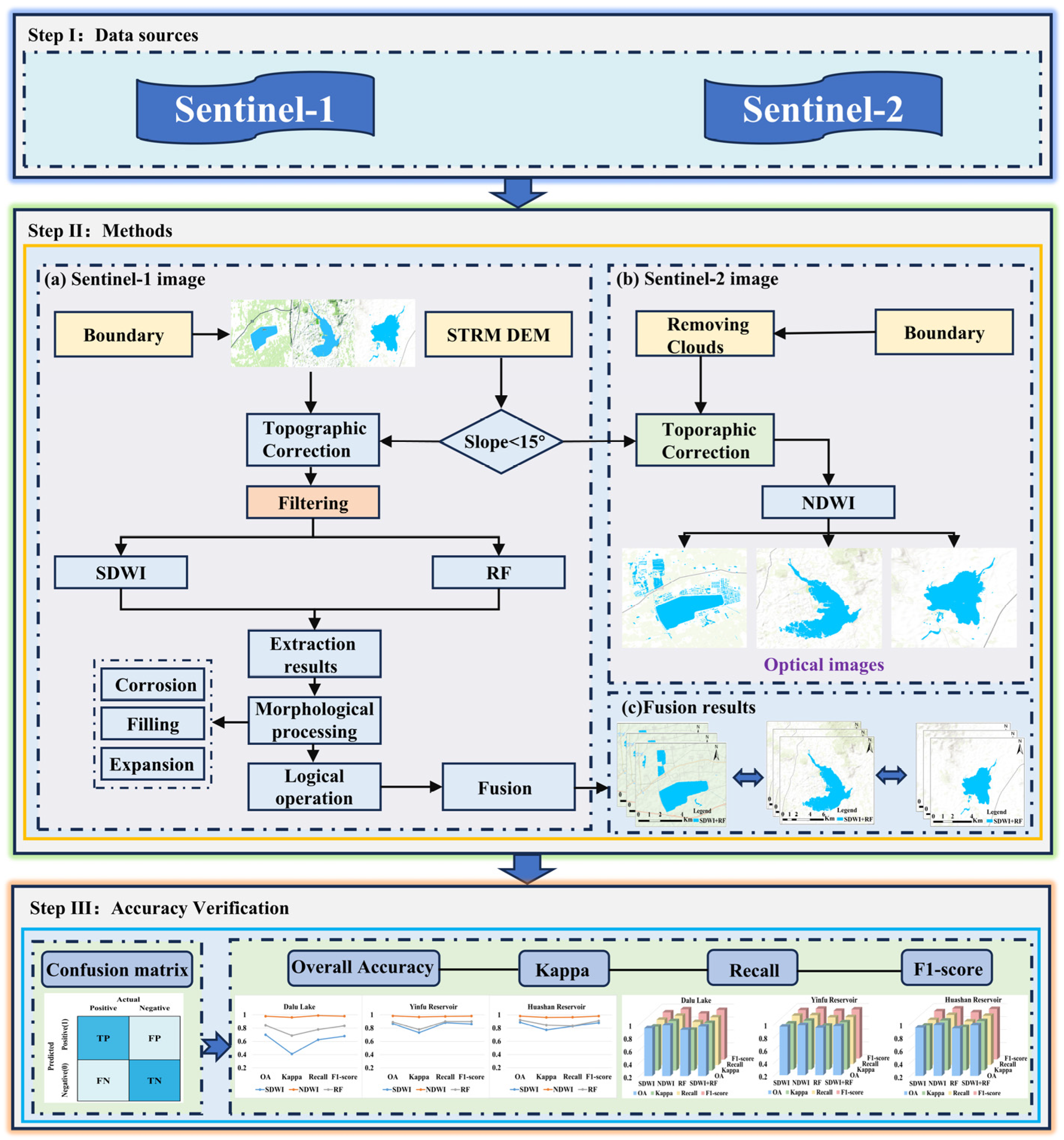
3.3. Experimental Process
3.4. Precision Evaluation Index
4. Result Analysis and Verification
4.1. Water Body Extraction Results and Analysis
- (1)
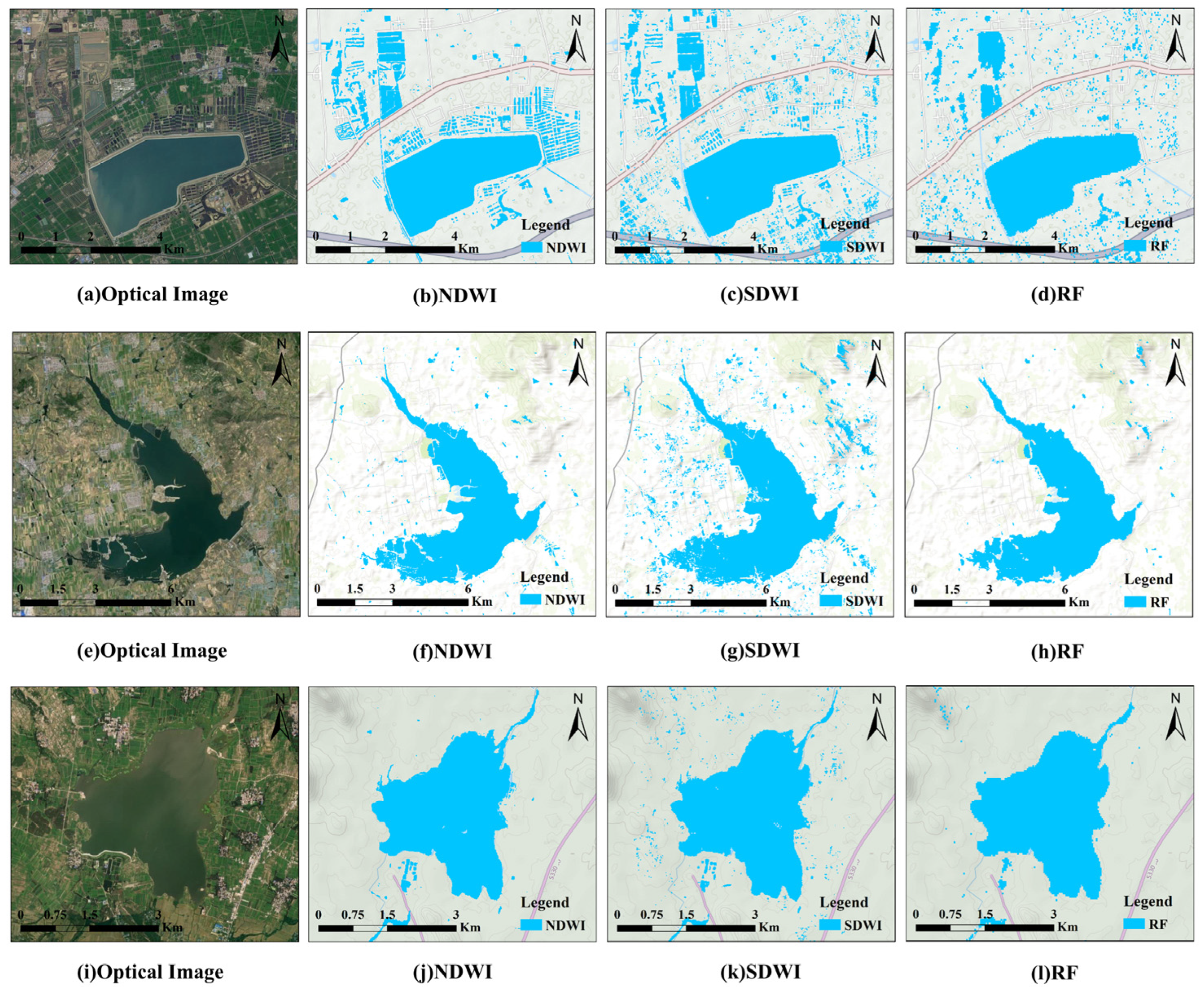
- NDWI was used to extract water body from Sentinel-2 images and the results are shown in Figure 6b,f,j. Compared with the optical images, it can be clearly seen that the water body regions are accurately and continuously identified, showing high consistency with the water body distribution in the original images. Moreover, NDWI can accurately identify small water bodies, indicating that this method has high sensitivity in water body extraction. According to the statistical results in Table 2, the overall accuracy of the three study areas reached 97.9%, 98.4%, and 98.3%, respectively, showing the high precision and reliability of the method in water extraction.
- (2)
- Figure 6c,g,k show the results of the water body extraction process from the SAR images using the SDWI. Compared with Figure 6a,e,i, the water bodies extracted by the SDWI method have a large error. This is mainly due to the fact that SAR images are susceptible to noise interference, resulting in some non-water-body areas being misjudged as water body areas. According to the statistical data in Table 2, the overall accuracies of the SDWI method in the three study areas are 70%, 86.6%, and 86.8%, respectively, which are significantly lower than those derived using the NDWI method. However, the SDWI demonstrates higher precision in identifying small water bodies, effectively distinguishing smaller water areas.
- (3)
- Figure 6d,h,l show the water body results extracted using the RF algorithm. Compared with optical images, the RF algorithm has less error in the recognition of large-area water bodies. However, there are obvious errors in the extraction of small water bodies, especially in the extraction of small water bodies such as ponds and irrigation canals, and the classification results are not ideal.
| Areas | Methods | OA (%) | Kappa (%) | Recall (%) | F1-Score (%) |
|---|---|---|---|---|---|
| Dalu Lake | NDWI | 0.979 | 0.961 | 0.989 | 0.980 |
| SDWI | 0.700 | 0.410 | 0.625 | 0.679 | |
| RF | 0.843 | 0.688 | 0.779 | 0.835 | |
| Yinfu Reservoir | NDWI | 0.984 | 0.968 | 0.976 | 0.981 |
| SDWI | 0.866 | 0.732 | 0.881 | 0.860 | |
| RF | 0.890 | 0.779 | 0.898 | 0.898 | |
| Huashan Reservoir | NDWI | 0.983 | 0.962 | 0.965 | 0.982 |
| SDWI | 0.886 | 0.773 | 0.844 | 0.880 | |
| RF | 0.924 | 0.846 | 0.835 | 0.910 |
4.2. Morphological Processing and Fusion Results
- (1)
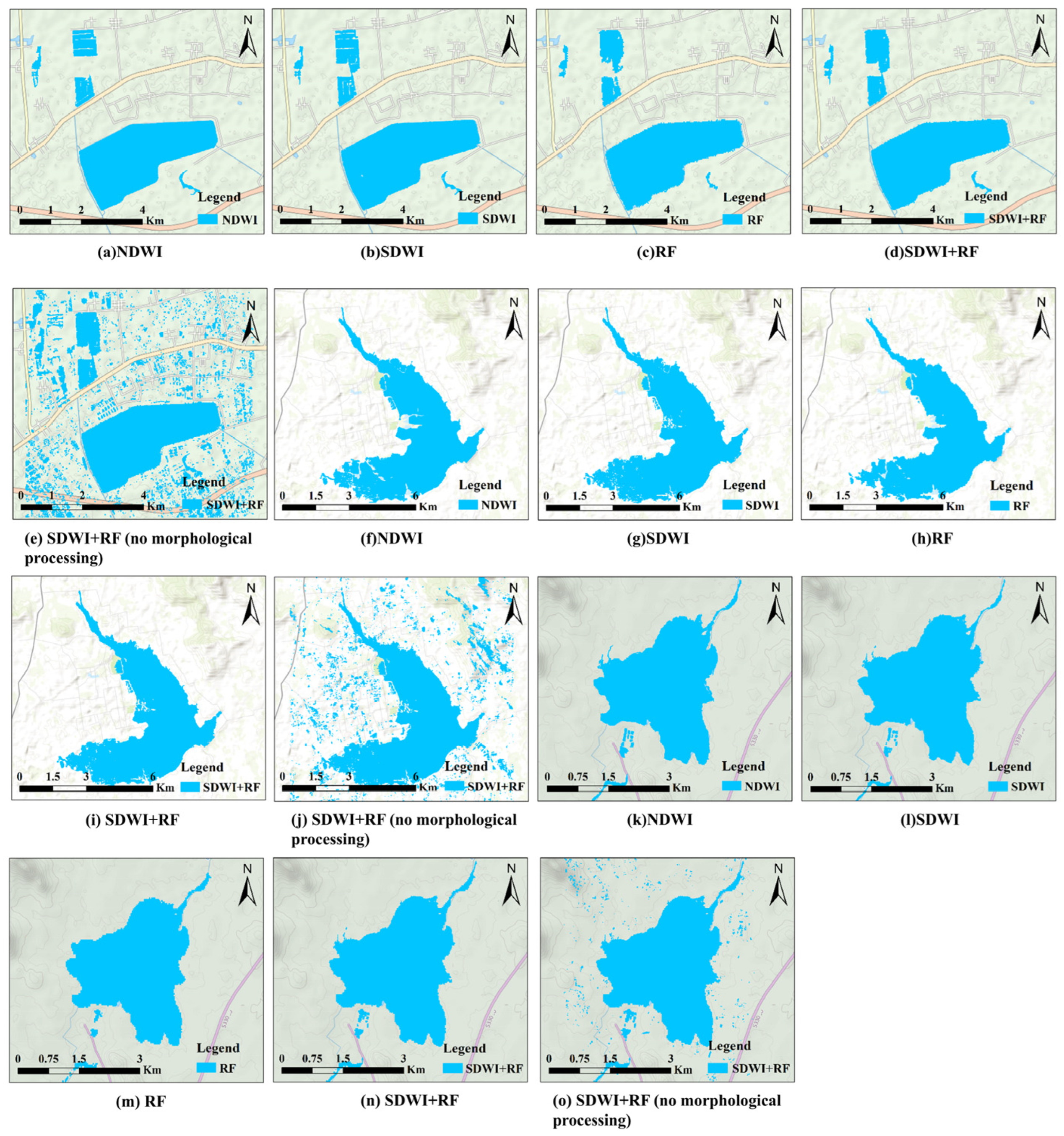
- Figure 7a,f,k illustrate the water body extraction results derived from the NDWI applied to Sentinel-2 optical images. The NDWI leverages the spectral characteristic differences between the green and near-infrared bands to effectively suppress the interference from non-water-body features (such as vegetation and soil), while enhancing water body characteristics. When comparing the water body extracted using this method with the original optical imagery, the overall accuracies in the three study areas are 98.4%, 98.5%, and 98.4%, respectively, demonstrating high precision and stability.
- (2)
- The SDWI-based water body extraction results from SAR images exhibit noticeable misclassifications; as shown in Figure 7b,g,l, there are numerous blue spots in non-water areas (misidentified as water bodies) and white spots in water body areas (misidentified as non-water bodies). At the same time, there are obvious misidentification phenomena. Although the SDWI method can clearly identify small water bodies, and the overall accuracy is more than 94%, as shown in Table 3, its sensitivity to noise and limitations in complex environments significantly affect the accuracy of water body extraction.
- (3)
- The water extraction results obtained using RF with morphological post-processing are illustrated in Figure 7c,h,m. The RF method exhibits strong adaptability to complex environments and achieves high accuracy in identifying extensive water bodies. However, the algorithm shows limitations when applied to small or fragmented water bodies, which are often misclassified as non-water bodies due to their limited spatial continuity and weak scattering signatures. In the interleaving areas of water bodies and non-water bodies, the backscattering characteristics of small non-water areas (such as shallow banks, bare soil, or areas with low vegetation cover) are similar to those of neighboring water bodies, and these are easily misidentified as water bodies. There are some local errors in the extraction results.
- (4)
- Figure 7d,i,n show the water results extracted by fusing the SDWI and RF methods. Compared with the SDWI alone, the fusion derives results that effectively reduce the large area of misidentification, especially in the relatively simple water body area. The fusion method makes full use of the advantages of the RF algorithm in large-scale water body identification and avoids the sensitivity of the SDWI method to noise and complex environments. In addition, compared with the RF method alone, the fusion results were effectively supplemented in the area of unidentified small water bodies, effectively making up for the shortcomings of the single method and improving the accuracy of the overall extraction.
- (5)
- Figure 7e,j,o present the results of the direct fusion of the SDWI and RF extraction results without morphological processing. This direct fusion can, to some extent, supplement the recognition differences of a single algorithm, such as filling in the tiny water body missed by RF; however, due to the fact that the original results of the SDWI are easily interfered with by SAR speckle noise, “false water patches” are generated in areas such as building shadows and bare soil, resulting in superposition, retention of noise, and misjudgment. This leads to a dense concentration of false water body patches in the fusion results, seriously interfering with the boundaries and scope of the real water bodies and resulting in a significant deviation of the water body results from reality.
| Areas | Methods | OA (%) | Kappa (%) | Recall (%) | F1-Score (%) |
|---|---|---|---|---|---|
| Dalu Lake | NDWI | 0.984 | 0.968 | 0.965 | 0.981 |
| SDWI | 0.942 | 0.882 | 0.903 | 0.933 | |
| RF | 0.917 | 0.833 | 0.868 | 0.915 | |
| SDWI + RF | 0.969 | 0.939 | 0.941 | 0.970 | |
| SDWI + RF (no morphological processing) | 0.685 | 0.371 | 0.593 | 0.654 | |
| Yinfu Reservoir | NDWI | 0.985 | 0.969 | 0.968 | 0.982 |
| SDWI | 0.963 | 0.925 | 0.961 | 0.958 | |
| RF | 0.945 | 0.890 | 0.933 | 0.949 | |
| SDWI + RF | 0.972 | 0.943 | 0.938 | 0.971 | |
| SDWI + RF (no morphological processing) | 0.853 | 0.706 | 0.893 | 0.856 | |
| Huashan Reservoir | NDWI | 0.984 | 0.969 | 0.971 | 0.985 |
| SDWI | 0.945 | 0.891 | 0.893 | 0.943 | |
| RF | 0.934 | 0.869 | 0.871 | 0.927 | |
| SDWI + RF | 0.981 | 0.961 | 0.958 | 0.978 | |
| SDWI + RF (no morphological processing) | 0.868 | 0.738 | 0.900 | 0.873 |
5. Conclusions
Author Contributions
Funding
Institutional Review Board Statement
Informed Consent Statement
Data Availability Statement
Acknowledgments
Conflicts of Interest
References
- Ye, F.; Zhang, R.; Xu, X.; Wu, K.; Zheng, P.; Li, D. Water body segmentation of SAR images based on SAR image reconstruction and an improved UNet. IEEE Geosci. Remote Sens. Lett. 2023, 21, 4010005. [Google Scholar] [CrossRef]
- Acharya, T.D.; Lee, D.H.; Yang, I.T.; Lee, J.K. Identification of water bodies in a Landsat 8 OLI image using a J48 decision tree. Sensors 2016, 16, 1075. [Google Scholar] [CrossRef] [PubMed]
- Chen, J.; Wang, Y.; Wang, J.; Zhang, Y.; Xu, Y.; Yang, O.; Chen, X. The performance of Landsat-8 and Landsat-9 data for water body extraction based on various water indices: A comparative analysis. Remote Sens. 2024, 16, 1984. [Google Scholar] [CrossRef]
- Wang, J.; Jia, D.; Xue, J.; Wu, Z.; Song, W. Automatic water body extraction from SAR images based on MADF-Net. Remote Sens. 2024, 16, 3419. [Google Scholar] [CrossRef]
- Perez-Torres, W.I.; Uman-Flores, D.A.; Quispe-Quispe, A.B.; Palomino-Quispe, F.; Bezerra, E.; Leher, Q.; Alvarez, A.B. Exploratory analysis using deep learning for water-body segmentation of Peru’s high-mountain remote sensing images. Sensors 2024, 24, 5177. [Google Scholar] [CrossRef]
- Huang, X.; Xie, C.; Fang, X.; Zhang, L. Combining pixel- and object-based machine learning for identification of water-body types from urban high-resolution remote-sensing imagery. IEEE J. Sel. Top. Appl. Earth Obs. Remote Sens. 2015, 8, 2097–2110. [Google Scholar] [CrossRef]
- Di Vittorio, C.A.; Georgakakos, A.P. Land cover classification and wetland inundation mapping using MODIS. Remote Sens. Environ. 2018, 204, 1–17. [Google Scholar] [CrossRef]
- Xie, L.; Zhang, H.; Wang, C.; Chen, F. Water-body types identification in urban areas from RADARSAT-2 fully polarimetric SAR data. Int. J. Appl. Earth Obs. Geoinf. 2016, 50, 10–25. [Google Scholar] [CrossRef]
- Jain, S.K.; Singh, R.D.; Jain, M.K.; Lohani, A.K. Delineation of flood-prone areas using remote sensing techniques. Water Resour. Manag. 2005, 19, 333–347. [Google Scholar] [CrossRef]
- Zhang, F.; Li, J.; Zhang, B.; Shen, Q.; Ye, H.; Wang, S.; Lu, Z. A simple automated dynamic threshold extraction method for the classification of large water bodies from Landsat-8 OLI water index images. Int. J. Remote Sens. 2018, 39, 3429–3451. [Google Scholar] [CrossRef]
- Jain, S.K.; Saraf, A.K.; Goswami, A.; Ahmad, T. Flood inundation mapping using NOAA AVHRR data. Water Resour. Manag. 2006, 20, 949–959. [Google Scholar] [CrossRef]
- McFeeters, S.K. The Use of the Normalized Difference Water Index (NDWI) in the delineation of open water features. Int. J. Remote Sens. 1996, 17, 1425–1432. [Google Scholar] [CrossRef]
- Xu, H. Modification of Normalised Difference Water Index (NDWI) to enhance open water features in remotely sensed imagery. Int. J. Remote Sens. 2006, 27, 3025–3033. [Google Scholar] [CrossRef]
- Buma, W.G.; Lee, S.I.; Seo, J.Y. Recent surface water extent of Lake Chad from multispectral sensors and GRACE. Sensors 2018, 18, 2082. [Google Scholar] [CrossRef] [PubMed]
- Feyisa, G.L.; Meilby, H.; Fensholt, R.; Proud, S.R. Automated water extraction index: A new technique for surface water mapping using Landsat imagery. Remote Sens. Environ. 2014, 140, 23–35. [Google Scholar] [CrossRef]
- Tian, H.; Li, W.; Wu, M.; Huang, N.; Li, G.; Li, X.; Niu, Z. Dynamic monitoring of the largest freshwater lake in China using a new water index derived from high spatiotemporal resolution Sentinel-1A data. Remote Sens. 2017, 9, 521. [Google Scholar] [CrossRef]
- Kim, J.; Kim, H.; Jeon, H.; Jeong, S.H.; Song, J.; Vadivel, S.K.P.; Kim, D.J. Synergistic use of geospatial data for water body extraction from Sentinel-1 images for operational flood monitoring across Southeast Asia using Deep Neural Networks. Remote Sens. 2021, 13, 4759. [Google Scholar] [CrossRef]
- Jin, H.; Mountrakis, G.; Stehman, S.V. Assessing integration of intensity, polarimetric scattering, interferometric coherence and spatial texture metrics in PALSAR-derived land cover classification. ISPRS J. Photogramm. Remote Sens. 2014, 98, 70–84. [Google Scholar] [CrossRef]
- Zhang, M.; Xie, C.; Tian, B.; Yang, Y.; Guo, Y.; Zhu, Y.; Bian, S. Application of gated recurrent unit neural network for flood extraction from synthetic aperture radar time series. Water 2023, 15, 3779. [Google Scholar] [CrossRef]
- Ottinger, M.; Clauss, K.; Kuenzer, C. Large-scale assessment of coastal aquaculture ponds with Sentinel-1 time series data. Remote Sens. 2017, 9, 440. [Google Scholar] [CrossRef]
- Tian, P.; Liu, Y.; Li, J.; Pu, R.; Cao, L.; Zhang, H.; Yang, Y. Mapping coastal aquaculture ponds of China using Sentinel SAR images in 2020 and Google Earth Engine. Remote Sens. 2022, 14, 5372. [Google Scholar] [CrossRef]
- Du, P.; Samat, A.; Waske, B.; Liu, S.; Li, Z. Random forest and rotation forest for fully polarized SAR image classification using polarimetric and spatial features. ISPRS J. Photogramm. Remote Sens. 2015, 105, 38–53. [Google Scholar] [CrossRef]
- Fu, B.; Xie, S.; He, H.; Zuo, P.; Sun, J.; Liu, L.; Huang, L.; Fan, D.; Gao, E. Synergy of multi-temporal polarimetric SAR and optical image satellite for mapping of marsh vegetation using object-based random forest algorithm. Ecol. Indic. 2021, 131, 108173. [Google Scholar] [CrossRef]
- Shao, Z.; Ahmad, M.N.; Javed, A. Comparison of random forest and XGBoost classifiers using integrated optical and SAR features for mapping urban impervious surface. Remote Sens. 2024, 16, 665. [Google Scholar] [CrossRef]
- Van Beijma, S.; Comber, A.; Lamb, A. Random Forest Classification of Salt Marsh Vegetation Habitats Using Quad-Polarimetric Airborne SAR, Elevation and Optical RS Data. Remote Sens. Environ. 2014, 149, 118–129. [Google Scholar] [CrossRef]
- Du, Q.; Li, G.; Chen, D.; Qi, S.; Zhou, Y.; Wang, F.; Cao, Y. Extracting water body data based on SDWI and threshold segmentation: A case study in permafrost area surrounding Salt Lake in Hoh Xil, Qinghai-Tibet Plateau, China. Res. Cold Arid Reg. 2023, 15, 202–209. [Google Scholar] [CrossRef]
- Guo, J.; Luan, Y.; Li, Z.; Liu, X.; Li, C.; Chang, X. Mozambique flood (2019) caused by tropical cyclone Idai monitored from Sentinel-1 and Sentinel-2 images. IEEE J. Sel. Top. Appl. Earth Obs. Remote Sens. 2021, 14, 8761–8772. [Google Scholar] [CrossRef]
- Jia, S.; Xue, D.; Li, C.; Zheng, J.; Li, W. Study on new method for water area information extraction based on Sentinel-1 data. Yangtze River 2019, 50, 213–217. [Google Scholar]


| Data Sets | Date | Spatial Resolution | Polarization Mode/Band |
|---|---|---|---|
| Sentinel-1 | 1 October 2023–1 December 2023 | 10 m × 10 m | VV and VH |
| Sentinel-2 | 1 October 2023–1 December 2023 | 10 m × 10 m | B3 and B8 |
Disclaimer/Publisher’s Note: The statements, opinions and data contained in all publications are solely those of the individual author(s) and contributor(s) and not of MDPI and/or the editor(s). MDPI and/or the editor(s) disclaim responsibility for any injury to people or property resulting from any ideas, methods, instructions or products referred to in the content. |
© 2025 by the authors. Licensee MDPI, Basel, Switzerland. This article is an open access article distributed under the terms and conditions of the Creative Commons Attribution (CC BY) license (https://creativecommons.org/licenses/by/4.0/).
Share and Cite
Zhai, M.; Shen, H.; Cao, Q.; Ding, X.; Xin, M. Water Body Extraction Methods for SAR Images Fusing Sentinel-1 Dual-Polarized Water Index and Random Forest. Sensors 2025, 25, 4868. https://doi.org/10.3390/s25154868
Zhai M, Shen H, Cao Q, Ding X, Xin M. Water Body Extraction Methods for SAR Images Fusing Sentinel-1 Dual-Polarized Water Index and Random Forest. Sensors. 2025; 25(15):4868. https://doi.org/10.3390/s25154868
Chicago/Turabian StyleZhai, Min, Huayu Shen, Qihang Cao, Xuanhao Ding, and Mingzhen Xin. 2025. "Water Body Extraction Methods for SAR Images Fusing Sentinel-1 Dual-Polarized Water Index and Random Forest" Sensors 25, no. 15: 4868. https://doi.org/10.3390/s25154868
APA StyleZhai, M., Shen, H., Cao, Q., Ding, X., & Xin, M. (2025). Water Body Extraction Methods for SAR Images Fusing Sentinel-1 Dual-Polarized Water Index and Random Forest. Sensors, 25(15), 4868. https://doi.org/10.3390/s25154868


