
Anomaly Field Extraction Based on Layered-Earth Model and Equivalent Eddy Current Inversion: A Case Study of Borehole zk506 in Baishiquan, Xinjiang

 , , ,
, , ,
Abstract
1. Introduction
2. Theoretical Methods and Case Studies Verification
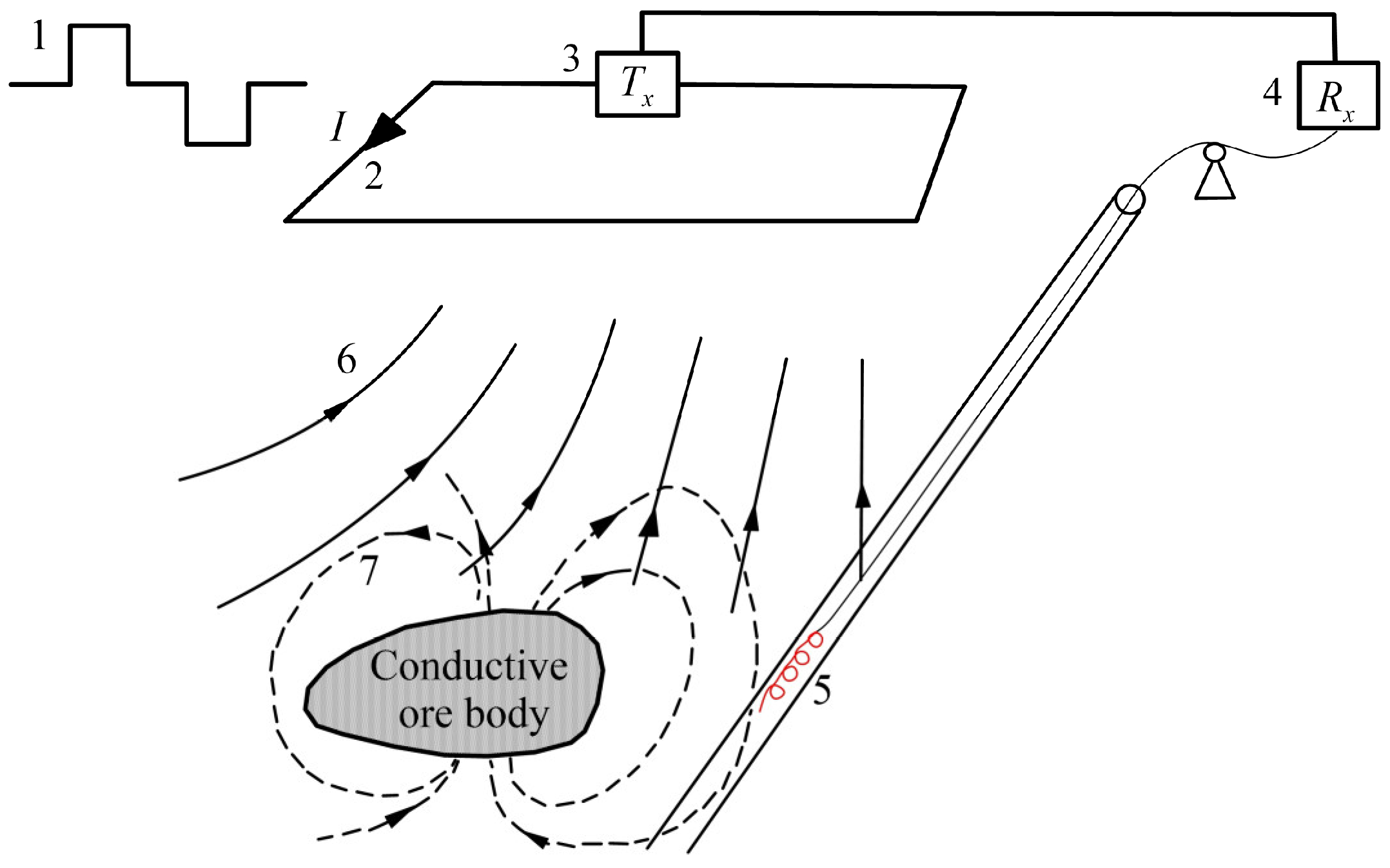
2.1. Equivalent Eddy Current Theory
2.2. Background Field Calculation
2.3. Example of Anomaly Field Extraction
2.4. Robustness Evaluation
3. Baishiquan BHTEM Survey
3.1. Geological Background
3.2. BHTEM Data Acquisition
3.3. Pure Anomaly Extraction and Equivalent Eddy Current Inversion
4. Discussion
5. Conclusions
Author Contributions
Funding
Data Availability Statement
Acknowledgments
Conflicts of Interest
References
- Teng, J.W.; Xue, G.Q.; Song, M.C. Theory on exploring mineral resources in the second deep space and practices with electromagnetic method. Chin. J. Geophys. 2022, 65, 3975–3985. [Google Scholar] [CrossRef]
- Dong, S.W.; Li, T.D.; Cheng, X.H.; Wei, W.B.; Gao, R.; Lü, Q.T.; Yang, J.S.; Wang, X.Q.; Chen, Q.C.; Shi, Y.L.; et al. Progress of deep exploration in mainland China: A review. Chin. J. Geophys. 2012, 55, 3884–3901. [Google Scholar] [CrossRef]
- Li, J.; Tang, J.T.; Xu, Z.M.; Yan, H. Magnetotelluric noise suppression base on signal-to-noise identification in ore concentration area. Chin. J. Geophys. 2017, 60, 722–737. [Google Scholar] [CrossRef]
- Di, Q.Y.; Zhu, R.X.; Xue, G.Q.; Yin, C.C.; Li, X. New development of the Electromagnetic (EM) methods for deep exploration. Chin. J. Geophys. 2019, 62, 2128–2138. [Google Scholar] [CrossRef]
- Xue, G.Q.; Zhang, L.B.; Zhou, N.N.; Chen, W.Y. Developments measurements of TEM sounding in China. Geol. J. 2020, 55, 1636–1643. [Google Scholar] [CrossRef]
- Eadie, T.; Staltari, G. Introduction to Downhole Electromagnetic Methods. Explor. Geophys. 1987, 18, 247–351. [Google Scholar] [CrossRef]
- Cull, J.; Massie, M. Noise Reduction for Down-hole Three-component TEM probes. In Proceedings of the ASEG 15th Geophysical Conference and Exhibition, Brisbane, Australia, 5–8 August 2001. [Google Scholar] [CrossRef]
- Cull, J.P. Sensor response and resolution in downhole TEM data. Explor. Geophys. 1996, 27, 167–169. [Google Scholar] [CrossRef]
- Duncan, A.C. Interpretation of down-hole transient EM data using current filaments. Explor. Geophys. 1987, 18, 36–39. [Google Scholar] [CrossRef]
- Bishop, J.R.; Lewis, R.J.G.; Macnae, J.C. Down-Hole Electromagnetic Surveys at Renison Bell, Tasmania. Explor. Geophys. 1987, 18, 265–277. [Google Scholar] [CrossRef]
- Basford, P.; Hughes, N. Geophysical response of the Hercules base metal deposit: A case study from western Tasmania. Explor. Geophys. 2000, 31, 531–542. [Google Scholar] [CrossRef]
- Hughes, N.A.; Ravenhurst, W. Three component DHEM surveying at Balcooma. Explor. Geophys. 1996, 27, 77–89. [Google Scholar] [CrossRef]
- Vella, L. Taking Downhole EM Underground, at Hill 50 Decline, Mount Magnet, Western Australia. Explor. Geophys. 1997, 28, 141–146. [Google Scholar] [CrossRef]
- Alan, K. Deep drill hole electromagnetic surveys for nickel/copper sulphides at Sudbury, Canada. Explor. Geophys. 1996, 27, 105–118. [Google Scholar] [CrossRef]
- Polzer, B. The role of borehole EM in the discovery and definition of the Kelly Lake Ni-Cu deposit, Sudbury, Canada. In SEG Technical Program Expanded Abstracts; Society of Exploration Geophysicists: Houston, TX, USA, 2000; pp. 1063–1066. [Google Scholar]
- Peters, B.; Buck, P. The Maggie Hays and Emily Ann nickel deposits, Western Australia: A geophysical case history. Explor. Geophys. 2000, 31, 210–221. [Google Scholar] [CrossRef]
- Wang, X.C.; Zhang, J.; Yang, Y.; Li, H.; Wu, S.K.; Wang, Z.A.; Zhi, Q.Q.; Wang, J.L.; WU, J.J.; Li, L.; et al. Geophysical investigation of the Xiarihamu Cu-Ni-Co deposit and its surrounding areas in East Kunlun, Qinghai Province. Ore Geol. Rev. 2025, 175, 106377. [Google Scholar] [CrossRef]
- Osipov, A.V.; Pleshakova, E.S.; Gataullin, S.T. Production processes optimization through machine learning methods based on geophysical monitoring data. Comput. Opt. 2024, 48, 633–642. [Google Scholar] [CrossRef]
- Yue, P.; Shangguan, B.; Hu, L.; Jiang, L.; Zhang, C.; Cao, Z.; Pan, Y. Towards a training data model for artificial intelligence in earth observation. Int. J. Geogr. Inf. Sci. 2022, 36, 2113–2137. [Google Scholar] [CrossRef]
- Yu, S.; Ma, J. Deep learning for geophysics: Current and future trends. Rev. Geophys. 2021, 59, e2021RG000742. [Google Scholar] [CrossRef]
- Zhou, S.; Wei, Y.; Lu, P.; Yu, G.; Wang, S.; Jiao, J.; Yu, P.; Zhao, J. A Deep Learning Gravity Inversion Method Based on a Self-Constrained Network and Its Application. Remote Sens. 2024, 16, 995. [Google Scholar] [CrossRef]
- Wu, X.; Ma, J.; Si, X.; Bi, Z.; Yang, J.; Gao, H.; Xie, D.; Guo, Z.; Zhang, J. Sensing prior constraints in deep neural networks for solving exploration geophysical problems. Proc. Natl. Acad. Sci. USA 2023, 120, e2219573120. [Google Scholar] [CrossRef]
- Zhang, J.; Deng, X.; Tan, H.D.; Lv, G.Y.; Wu, J.J.; Wang, X.C.; Yang, Y. A study of vector intersection for borehole transient electromagnetic method. Geophys. Geochem. Explor. 2015, 3, 572–579. [Google Scholar] [CrossRef]
- Barnett, C.T. Simple inversion of time-domain electromagnetic data. Geophysics 1984, 49, 925–933. [Google Scholar] [CrossRef]
- Fullagar, P.K. Inversion of Downhole TEM Data Using Circular Current Filaments. Explor. Geophys. 1987, 18, 341–344. [Google Scholar] [CrossRef]
- Yang, Y.; Deng, X.H.; Zhang, J.; Wu, J.J.; Wang, X.C. A borehole TEM anomaly inversion method. Geophys. Geochem. Explor. 2014, 4, 855–859. [Google Scholar] [CrossRef]
- Fullagar, P.K.; Schaa, R. Fast 3D inversion of transient electromagnetic (TEM) resistive limit data. In Proceedings of the 84th Annual International Meeting, SEG, Denver, CO, USA, 26–31 October 2014. Expanded Abstracts. [Google Scholar]
- Fullagar, P.K.; Woods, D. Fast 3D inversion of “total field” resistive limit TEM data. In Proceedings of the 25th ASEG Conference, Adelaide, Australia, 21–24 August 2016. Extended Abstract. [Google Scholar]
- Qi, Y.; Zhi, Q.; Li, X.; Jing, X.; Qi, Z.; Sun, N.; Zhou, J.; Liu, W. Three-dimensional ground TEM inversion over a topographic earth considering ramp time. Chin. J. Geophys. 2021, 64, 2566–2577. [Google Scholar] [CrossRef]
- Key, K. 1D inversion of multi-component, multi-frequency marine CSEM data: Methodology and synthetic studies for resolving thin resistive layers. Geophysics 2009, 74, 9–20. [Google Scholar] [CrossRef]
- Anderson, W.L. Numerical integration of related Hankel transforms of orders 0 and 1 by adaptive digital filtering. Geophysics 1979, 44, 1287–1305. [Google Scholar] [CrossRef]
- Li, J.X.; Qin, K.Z.; Xu, X.W.; Sun, H.; Cheng, S.L.; Wu, H.; Mo, X.H. Geochemistry of Baishiquan Cu-Ni-bearing mafic-ultramafic complex in East Tianshan Xinjiang: Constraints on ore genesis and tectonic setting. Miner. Depos. 2007, 26, 43–57. [Google Scholar] [CrossRef]
- Chai, F.M.; Zhang, Z.C.; Mao, J.W.; Dong, L.H.; Zhang, Z.H.; Ye, H.S.; Wu, H.; Mo, X.H. Platinum Group Elements Geochemistry of Baishiquan Mafic-Ultramafic Intrusives in Central Tianshan Block, Xinjiang. Acta Geosci. Sin. 2006, 27, 123–128. [Google Scholar] [CrossRef]
- Qi, L.P.; Ma, J.L.; Yang, L.Z.; Ren, G.; Tian, J.S.; Wang, J.Z.; Wang, D.Y.; Ma, T. Discussion on the Search Method of Cu-Ni-sulfide Deposit in Baishiquan, Hami. Xinjiang. Xinjiang Geol. 2013, 31, 195–198. [Google Scholar] [CrossRef]
- Yang, L.Z.; Ren, G.; Qi, L.P.; Guo, Y.M.; Dong, J.Y. Metallogenic and exploration model of Cu-Ni-Sulfide deposit in belt of Baishiquan, East Tianshan, Xijiang. Xinjiang Geol. 2011, 29, 428–432. [Google Scholar] [CrossRef]
- Shao, X.L. Research for Geophysical Characteristics and Prospecting Application on Huangshan-Jingerquan Ultramafic Complex Belt in Eastern Tianshan of Xinjiang. Master’s Thesis, China University of Geosciences (Beijing), Beijing, China, 2012. [Google Scholar]


| Uniform Half-space | 108 | 100 | / | / | / | / |
| D-type | 108 | 500 | 50 | 50 | / | / |
| G-type | 108 | 50 | 50 | 500 | / | / |
| H-type | 108 | 500 | 50 | 50 | 10 | 5000 |
| Q-type | 108 | 50 | 50 | 5000 | 10 | 500 |
| Model | Uniform Half-Space | D-Type | G-Type | H-Type | Q-Type | |
|---|---|---|---|---|---|---|
| Channel Number | ||||||
| 2 | 3.96% | 2.07% | 1.59% | 2.49% | 1.60% | |
| 3 | 1.10% | 2.06% | 1.58% | 2.05% | 1.58% | |
| 5 | 0.20% | 1.57% | 1.17% | 0.94% | 1.17% | |
| 7 | 0.55% | 1.02% | 0.60% | 0.18% | 0.60% | |
| 8 | 0.53% | 0.73% | 0.32% | 0.40% | 0.31% | |
| 10 | 0.23% | 0.28% | 0.27% | 1.02% | 0.28% | |
| 12 | 0.15% | 0.13% | 0.75% | 1.47% | 0.75% | |
| 14 | 0.40% | 0.37% | 1.06% | 1.44% | 1.06% | |
| 15 | 0.25% | 0.19% | 0.69% | 1.22% | 0.69% | |
| 17 | 0.54% | 0.44% | 1.00% | 1.69% | 1.00% | |
| 19 | 0.73% | 0.64% | 1.26% | 1.94% | 1.26% | |
| 20 | 1.04% | 0.95% | 1.46% | 1.24% | 1.45% | |
| 23 | 1.09% | 1.02% | 1.75% | 1.64% | 1.74% | |
| 24 | 0.99% | 0.89% | 1.11% | 1.71% | 1.10% | |
| 25 | 1.01% | 0.95% | 1.59% | 1.19% | 1.58% | |
| 26 | 1.04% | 0.95% | 1.17% | 2.21% | 1.18% | |
| 27 | 1.12% | 1.03% | 1.55% | 0.99% | 1.53% | |
| 28 | 1.02% | 0.95% | 1.27% | 2.60% | 1.27% | |
| Parameter | ax (m) | ay (m) | az (m) | Dip (°) | DD (°) |
|---|---|---|---|---|---|
| 50.0 | 51.7 | 97.5 | 31.3 | 30.0 |
| Model | ||
|---|---|---|
| 1 | 108 | 300 |
| 2 | 108 | 290 |
| 3 | 108 | 310 |
| Number | Rock (ore) | Samples | Range | Average | (%) Range | Average |
|---|---|---|---|---|---|---|
| 1 | Silicified marble | 8 | 271–6099 | 2258.18 | 0.15–2.75 | 1.05 |
| 2 | Biotite gneiss | 2 | 292–3917 | 1069.46 | 1.54–2.09 | 1.79 |
| 3 | Granite | 11 | 369–11,656 | 1992.22 | 0.35–4.43 | 2.22 |
| 4 | Gabbro | 80 | 10–12,980 | 646 | 0.09–32.47 | 2.59 |
| 5 | Peridotite | 35 | 0–17,038 | 365 | 0.11–7.72 | 1.04 |
| 6 | Mineralized peridotite | 12 | 0.45–6875.4 | 88 | 10.99–50.9 | 28.38 |
| 7 | Pyroxene diorite | 6 | 162–4309 | 869 | 0.13–0.89 | 0.39 |
| 8 | Pyroxenite | 5 | 114–370 | 228 | 0.09–0.5 | 0.26 |
| 9 | Tuffaceous schist | 17 | 90–51,131 | 720 | 0.08–9.74 | 0.84 |
| 10 | Diorite | 13 | 198–13,387 | 1043 | 0.18–13.56 | 3.13 |
| 11 | Norite | 9 | 145–6283 | 1417 | 0.08–9.1 | 1.14 |
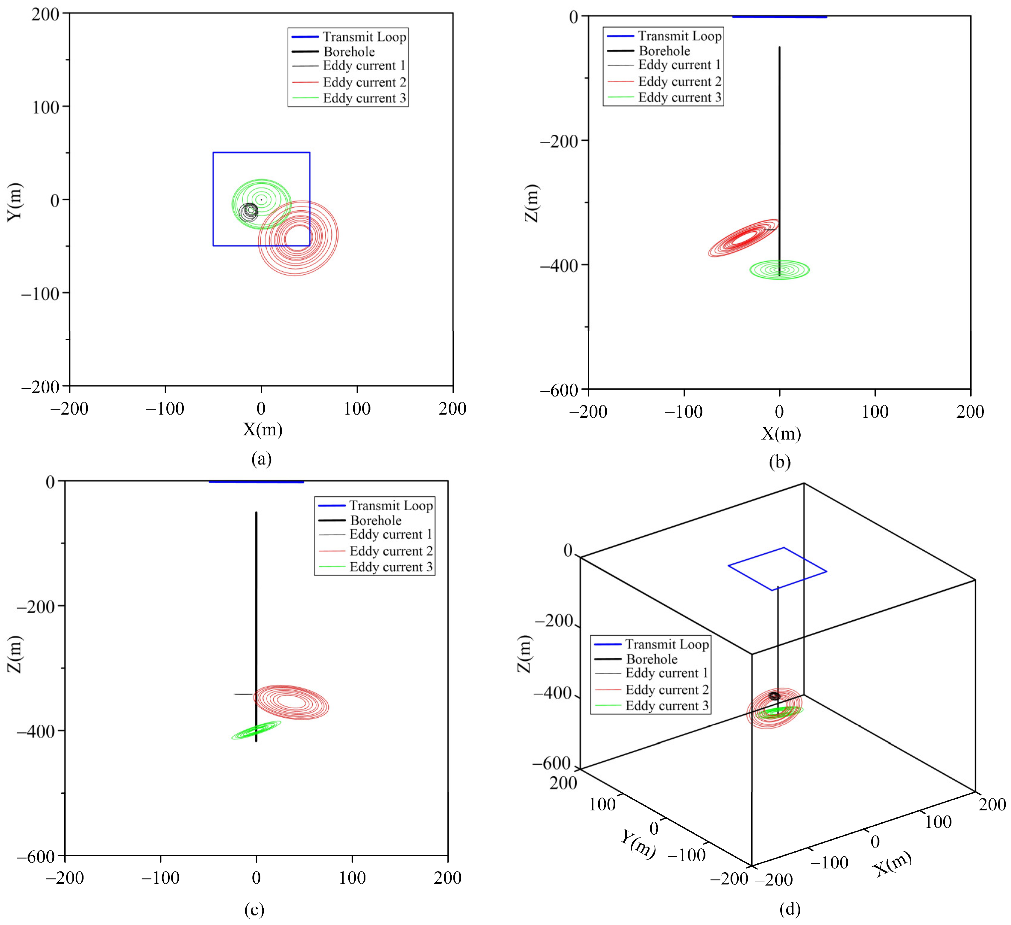
| Parameter | ax (m) | ay (m) | az (m) | R (m) | I (A) | Dip (°) | DD (°) | |
|---|---|---|---|---|---|---|---|---|
| Eddy Current | ||||||||
| 1 | −10 | −10 | −345 | 4 | 0.001 | 0 | 0 | |
| 2 | 40 | −40 | −362 | 15 | 0.005 | 20 | −30 | |
| 3 | 0 | 0 | −390 | 8 | 0.0005 | 20 | 20 | |
| Eddy Current | ax (m) | ay (m) | az (m) | Dip (°) | DD (°) |
|---|---|---|---|---|---|
| 1 | −10.5 | −10.5 | −350 | 0 | 0 |
| 2 | −39 | −38 | −361 | 20.8 | −29.2 |
| 3 | 0 | 0 | −401 | 20.1 | 20 |
Disclaimer/Publisher’s Note: The statements, opinions and data contained in all publications are solely those of the individual author(s) and contributor(s) and not of MDPI and/or the editor(s). MDPI and/or the editor(s) disclaim responsibility for any injury to people or property resulting from any ideas, methods, instructions or products referred to in the content. |
© 2025 by the authors. Licensee MDPI, Basel, Switzerland. This article is an open access article distributed under the terms and conditions of the Creative Commons Attribution (CC BY) license (https://creativecommons.org/licenses/by/4.0/).
Share and Cite
Yang, Y.; Zhang, J.; Zhi, Q.; Ou, Y.; Wang, X.; Wang, L.; Wu, J.; Deng, X. Anomaly Field Extraction Based on Layered-Earth Model and Equivalent Eddy Current Inversion: A Case Study of Borehole zk506 in Baishiquan, Xinjiang. Sensors 2025, 25, 3502. https://doi.org/10.3390/s25113502
Yang Y, Zhang J, Zhi Q, Ou Y, Wang X, Wang L, Wu J, Deng X. Anomaly Field Extraction Based on Layered-Earth Model and Equivalent Eddy Current Inversion: A Case Study of Borehole zk506 in Baishiquan, Xinjiang. Sensors. 2025; 25(11):3502. https://doi.org/10.3390/s25113502
Chicago/Turabian StyleYang, Yi, Jie Zhang, Qingquan Zhi, Yang Ou, Xingchun Wang, Lei Wang, Junjie Wu, and Xiaohong Deng. 2025. "Anomaly Field Extraction Based on Layered-Earth Model and Equivalent Eddy Current Inversion: A Case Study of Borehole zk506 in Baishiquan, Xinjiang" Sensors 25, no. 11: 3502. https://doi.org/10.3390/s25113502
APA StyleYang, Y., Zhang, J., Zhi, Q., Ou, Y., Wang, X., Wang, L., Wu, J., & Deng, X. (2025). Anomaly Field Extraction Based on Layered-Earth Model and Equivalent Eddy Current Inversion: A Case Study of Borehole zk506 in Baishiquan, Xinjiang. Sensors, 25(11), 3502. https://doi.org/10.3390/s25113502