Article

Use of Unmanned Surface Vehicles (USVs) in Water Chemistry Studies

by
Georgios Katsouras
1,*,
Elias Dimitriou
2,
Sotirios Karavoltsos
3,
Stylianos Samios
1,
Aikaterini Sakellari
3,
Angeliki Mentzafou
2,
Nikolaos Tsalas
1 and
Michael Scoullos
3
1
Athens Water and Sewerage Company S.A. (E.Y.D.A.P.)-Research and Development, Oropou 156, 11146 Athens, Greece
2
Institute of Marine Biological Resources and Inland Waters (IMBRIW), Hellenic Centre for Marine Research (HCMR), 46.7 km Athens-Sounio Ave., 19013 Anavyssos, Greece
3
Laboratory of Environmental Chemistry, Department of Chemistry, National and Kapodistrian University of Athens, Panepistimiopolis, 15784 Athens, Greece
*
Author to whom correspondence should be addressed.
Sensors 2024, 24(9), 2809; https://doi.org/10.3390/s24092809
Submission received: 19 February 2024 / Revised: 23 April 2024 / Accepted: 24 April 2024 / Published: 28 April 2024
(This article belongs to the Section Remote Sensors)

Abstract

:
Unmanned surface vehicles (USVs) equipped with integrated sensors are a tool valuable to several monitoring strategies, offering enhanced temporal and spatial coverage over specific timeframes, allowing for targeted examination of sites or events of interest. The elaboration of environmental monitoring programs has relied so far on periodic spot sampling at specific locations, followed by laboratory analysis, aiming at the evaluation of water quality at a catchment scale. For this purpose, automatic telemetric stations for specific parameters have been installed by the Institute of Marine Biological Resources and Inland Waters of Hellenic Centre for Marine Research (IMBRIW-HCMR) within several Greek rivers and lakes, providing continuous and temporal monitoring possibilities. In the present work, USVs were deployed by the Athens Water and Sewerage Company (EYDAP) as a cost-effective tool for the environmental monitoring of surface water bodies of interest, with emphasis on the spatial fluctuations of chlorophyll α, electrical conductivity, dissolved oxygen and pH, observed in Koumoundourou Lake and the rivers Acheloos, Asopos and Kifissos. The effectiveness of an innovative heavy metal (HM) system installed in the USV for the in situ measurements of copper and lead was also evaluated herewith. The results obtained demonstrate the advantages of USVs, setting the base for their application in real-time monitoring of chemical parameters including metals. Simultaneously, the requirements for accuracy and sensitivity improvement of HM sensors were noted, in order to permit full exploitation of USVs’ capacities.

1. Introduction

It is crucial for water catchments to maintain their water quality conditions and strive, if possible, to achieve a high ecological and chemical status by the year 2027 [1,2,3]. In recent decades, catchments have gained significant attention in global water policy discussions. Integrated Water Resources Management (IWRM) is increasingly acknowledged as a holistic approach [4,5,6], leading to the development of the Integrated Lake Basin Management (ILBM) to address basin-specific characteristics. Evaluating the effectiveness of catchment basin management schemes and practices is essential [7,8,9].
Strategies for monitoring water quality are vulnerable to the irregular and unpredictable nature of precipitation events and hazardous incidents, such as sewage discharge, combined sewer overflows and agricultural runoff, which can impact drinking water resources and recreational water bodies [8,10]. These events occur sporadically and are often not captured by traditional monitoring approaches, which are characterized by limitations in terms of their temporal and spatial scope [11,12]. Such limitations hinder the assessment of water-related pressures and the development of effective countermeasures [13]. While automatic monitoring stations offer the potential for near real-time monitoring of basic water quantity and quality parameters, they are constrained by their point measurement nature, requiring significant investments to achieve the desired spatial resolution [14].
The need for an enhanced monitoring strategy yielding complete datasets with higher spatial resolution has become critical, requiring an approach which would enable the prediction of water quality at the catchment scale and pave the way for its improvement [15,16,17,18,19]. Nowadays, innovative genetic algorithm-based equations can be employed as indices for comparing with observed data, yielding more realistic results compared to experimental data [20,21]. Another valuable tool is the application of satellite data, which provides high temporal and spatial coverage, although it is subject to specific timescales and parameters (e.g., chlorophyll α) with limitations based on weather conditions [22,23]. An innovative approach gaining rapid traction in water monitoring is the utilization of unmanned surface vehicles (USVs) [10,17,18,19,23,24,25,26]. Although several commercial USVs are already on the market, ongoing research remains dedicated to advancing the technology and uncovering novel applications for these vehicles.
In the framework of the Horizon 2020 INTCATCH project (G.A. No 689341), a range of USVs has been developed and demonstrated throughout Europe [26,27,28,29,30]. These prototypes of short-length USVs that can be controlled remotely or can use an autonomous sailing mode are equipped with innovative commercial systems providing valuable data on various aspects of water quality. The main parameters are physical such as electrical conductivity and temperature, chemical such as dissolved oxygen, pH and metals, as well as biological such as chlorophyll α. All those parameters constitute variable ecological quality elements both spatially and temporally, the reliable assessment of which requires the availability of multi-year monitoring data. USVs’ application eliminates the need for labor-intensive and expensive monitoring methods, assuring more efficient processes.
A more comprehensive evaluation of the water quality of rivers and lakes in Greece might become feasible through the combination of existing monitoring strategies with innovative technological tools such as USVs. The study areas comprise Lake Koumoundourou, a lagoon situated near the industrial zone of Athens, along with three rivers—Acheloos, Kifissos and Asopos—which are typical sites for investigating catchments in Greece. These areas are subject to agricultural, urban and industrial pressures, each exhibiting fluctuations of distinct physicochemical characteristics. These water bodies likely play crucial roles in the local ecosystems and communities they serve. They are characterized by a diverse nature and dynamics, facing several key anthropogenic pressures derived by industrial activities, extensive livestock farming in sub-basins draining into lakes or rivers and agricultural practices [31]. Additional activities potentially affecting water resources comprise fisheries, hydropower, recreation and cultural practices within the catchment area, including water abstraction for irrigation and drinking purposes [32]. These anthropogenic pressures also encompass various water quality challenges related to eutrophication and thus to occasional algae blooms [10,33].
The main objective of the present work is to demonstrate both the advantages and disadvantages of employing innovative and integrated USVs alongside telemetric stations within existing monitoring strategies for rivers and lakes in Greece, in order to achieve a more comprehensive evaluation of their water quality. For this purpose, the use of advanced technologies like USVs can provide valuable insight into the ecological status of these aquatic environments. Given the diverse nature of the study area—incorporating both a lake and multiple rivers—it is likely that data collected from USVs and potentially integrated with telemetric stations would offer a comprehensive understanding of water quality dynamics across different water bodies. This comprehensive approach enables the identification of specific issues, trends or variations in water quality parameters across these varied environments.
During demonstrations in Greece, significant points emerged regarding the exploitation of USV services, particularly those of interest to end-users. Notably, the use of USVs coupled with online sensors for water monitoring is a novel technology not only in Greece but globally, sparking interest among stakeholders and monitoring organizations. As sensor technology advances, the potential applications of USVs expand, with particular interest for monitoring and sampling in inland waters. Positive perspectives include the fast and flexible data collection, safe and easy data organization and storage, convenient access to sampling areas with limited accessibility, improved management of site sampling plans, provision of spatially distributed data and the creation of a safer working environment compared to typical survey methodologies. However, while USVs offer significant advantages, they also come with limitations. These may include the need for enhancements in Artificial Intelligence (AI) and Internet of Things (IoT) systems, the high cost of specialized sensors, the requisite level of expertise for proper operation, the necessity of sensor calibration before each use, and the time-consuming preparation prior to each sampling campaign. Additionally, improving sensors and electrodes, particularly in terms of selectivity, could further enhance the effectiveness of these vessels.

2. Materials and Methods

2.1. Unmanned Surface Vehicles’ Operation and Description

The Athens Water and Sewerage Company S.A (Athens, Greece) has been responsible since 2019 for the introduction and validation of USVs application within Greek catchments into the framework of Horizon 2020 INTCATCH project [10,23]. The system structure consists of an unmanned surface vehicle of approximately one meter in length (Figure 1) and several electronic components facilitating boat control and sensor data acquisition. The USV has a low profile to minimize wind resistance and can be deployed in as little as 25 cm of water, either operated manually using a remote control (RC) device with 500 m range or controlled via a tablet, which provides high-level instructions such as monitoring of a specific predefined area using autonomous navigation [26,27]. GO-Systemelektronic (GO-SYS) provided the electronic components that are housed within the boat. A BlueBox is responsible for overseeing the sensors and circuit boards [28]. It locally stores sensor data in a flash memory and transmits it to the Raspberry via a serial connection. The sensors are mounted to a two-piece frame, protecting them from damage and facilitating horizontal attachment to the underside of the USV. A lithium polymer (LiPo) battery, located in the back compartment of the USV, provides the necessary energy for continuous operation for up to 3 h. Data collected are streamed in real-time to a cloud-based information system [28] and then can be downloaded or accessed through the web-based application WAter QUality INspector (WAQUIN) for visualization [30]. During the data collection campaign, a mobile application [30] allows for real-time visualization of the data, presenting the results obtained using the specific color patterns of blue, green, yellow, orange and red, complying with an increasing values scale. All USV prototypes were equipped with commercially appropriate sensors from GO-SYS for the monitoring of standard parameters such as dissolved oxygen (DO), temperature (T), pH and electrical conductivity (EC). The integrated system of chemical parameters (pH, EC, T and DO) on the USVs was thoroughly validated at University of Natural Resources and Life Sciences in Vienna (BOKU) [29]. Moreover, it should be underlined that the measurements by the USVs’ sensors were in very good agreement with parallel measurements performed in the field with portable devices and in the EYDAP laboratory with standard analytical methods. It is noteworthy to mention that the USVs can be seamlessly integrated with other commercial sensors (e.g., depth sensor) and even cameras. In this work, constant visual observation of the study area was essential, highlighting the versatility and adaptability of USVs in environmental monitoring applications. Among the INTCATCH USVs, two were equipped with specialized sensors: one for chlorophyll α (Chlα) and the other for heavy metals (HMs). These autonomous USVs, namely the ‘Chlα’ USV and ‘HM and Sampling’ USV were employed herewith for water chemistry studies. The ‘HM and Sampling’ USV, in particular, was equipped with an autonomous sampling system designed for collecting water samples for testing in the laboratory.
‘Chlα’ USV: This USV (Figure 1a) is equipped with a Turner Designs CYCLOPS-7 Submersible Fluorometer/Turbidimeter, an accurate single channel detector measuring Chlα with a detection limit of 0.03 μg L−1. A set of three additional probes provides measurements of DO at a range of 0–20 mg L−1 with a resolution of 0.1 mg L−1 and a measuring frequency of ≥1 s, T at a range of 0–50 °C, pH with a resolution of 0.05 and EC at a range of 40–4000 μS cm−1 and a resolution of 1 μS cm−1.
‘HM and Sampling’ USV: Besides the basic set of probes measuring standard parameters (DO, T, pH and EC), this USV (Figure 1b) is equipped with an easy-to-use system for Pb and Cu measurement via the Square Wave Anodic Stripping Voltammetry (SWASV) method, and also a sampling system enabling the collection of four (4) different water samples of 0.5 L each using peristaltic pumps.

2.2. Hydro-Telemetric Stations

The Institute of Marine Biological Resources and Inland Waters (IMBRIW) of the Hellenic Centre for Marine Research (HCMR) has established an extended network of automatic telemetric stations across various lakes and rivers in Greece [34]. Stations situated at Koumoundourou Lake and Kifissos estuaries (Table 1, Figure 2) provide real-time data at an hourly basis for parameters including water level, pH, EC, T, DO and Oxidation-Reduction Potential (ORP). At the telemetric station within Koumoundourou Lake, salinity measurements are also recorded together with the daily averaged quality index based on DO [35] and the Canadian Council of Ministers of the Environment Water Quality Index (CCMEWQI) [36] fluctuation.

2.3. Metals System

The low-cost fluidic innovative metals system is based on the method of Square Wave Anodic Stripping Voltammetry (SW-ASV) for the determination of lead (Pb) and copper (Cu). The performance characteristics of the measuring system installed on the USV for the analysis of Pb and Cu were obtained under controlled laboratory conditions, utilizing a calibration curve prepared with mixed solutions of Cu and Pb, with a Pb:Cu ratio 1:4 [37]. The limits of detection (LOD) were estimated to be equal to 4 and 7 µg L−1 for Pb and Cu, respectively. De Vito-Francesco et al. (2022) was aware that the limit of quantification (LOQ) values of the metals system [38] were not low enough to address the limits of the environmental quality standards (EQS) established by the Water Framework Directive (WFD) [39]. On the other hand, results indicate that the developed integrated metals system is a promising tool for investigative monitoring according to the WFD, i.e., to ascertain the impact of urban and/or accidental pollution sources in inland surface waters [38]. Measurement precision levels, evaluated as reproducibility and given as relative standard deviation (RSD in %), were 11–18% and 6–10% for Pb and Cu, respectively, which is considered satisfactory for on-site measuring systems [38].
The Square Wave Anodic Stripping Voltammetry Heavy Metal System operates following several sequential steps [37]:
  • Conditioning Step: The working electrode is subjected to a positive potential (or at least 0.0 V) to prepare for the subsequent steps with a deposition time of 180 s.
  • Deposition Step: A deposition potential is applied to the working electrode, causing the reduction and deposition of certain metals or other species present in the sample onto the electrode surface. The deposition process occurs based on mass transport, and typically occurs at a thin interface between the sample and electrode with a potential from −1.2 to −1 V [37] for 200 s. In flow-through mode or under stirring conditions, an increase in the signal can be observed.
  • Equilibration Step: This step allows for the equalization of ion concentrations within the boundaries of the electrode surface, ensuring uniformity prior to proceeding to the next step. The equilibrium step is applied for 20 s, while the peristaltic pump is stopped.
  • Stripping Step: Metals previously reduced and deposited onto the electrode during the deposition step are now released (oxidized) by applying a square wave potential within a specific range. Each metal undergoes oxidation at a specific potential value, resulting in the recording of various peaks at different potentials. The electrical current measured during this process is proportional to the concentration of the metals. Metal concentrations in the sample solution are determined through the interpretation of the voltammograms obtained using appropriate software. The peak height or area is compared to standard concentrations for calculation purposes.
To perform the above method, a metals measuring system is required, including a potentiostat, a sensing electrode system (screen-printed sensors), a flow cell, a peristaltic pump, software and a data processing system [37,38].
An electrochemical analytical system was developed and optimized exclusively in the framework of the INTCATCH project for detecting heavy metals in surface water [38]. The system consists of a miniaturized sensing device integrated into a microfluidic flow cell, which is part of a flow system including a pump, a gas bubble trap and a data acquisition device. Initial tests were conducted using synthetic water samples containing cadmium, copper, lead and zinc, in order to evaluate the capabilities of this technology.
Following its performance evaluation with real water samples in the laboratory, the device was successfully integrated into the ‘HM and Sampling’ USV, creating an autonomous and remote-controlled system capable of detecting lead and copper in surface waters and simultaneously collecting water samples. This integrated system underwent validation through indoor and outdoor experiments at BOKU and was provided to the INTCATCH end-users for further validation and use [38].

2.4. Study Area and Data Collection

Introducing an innovative water quality monitoring strategy in Greece using USVs for the first time in 2019 is a significant step toward enhancing environmental monitoring practices in the country. The study area comprising Koumoundourou Lake and three rivers—Acheloos, Asopos and Kifissos—holds immense importance in understanding and managing Greece’s water resources (Figure 3).

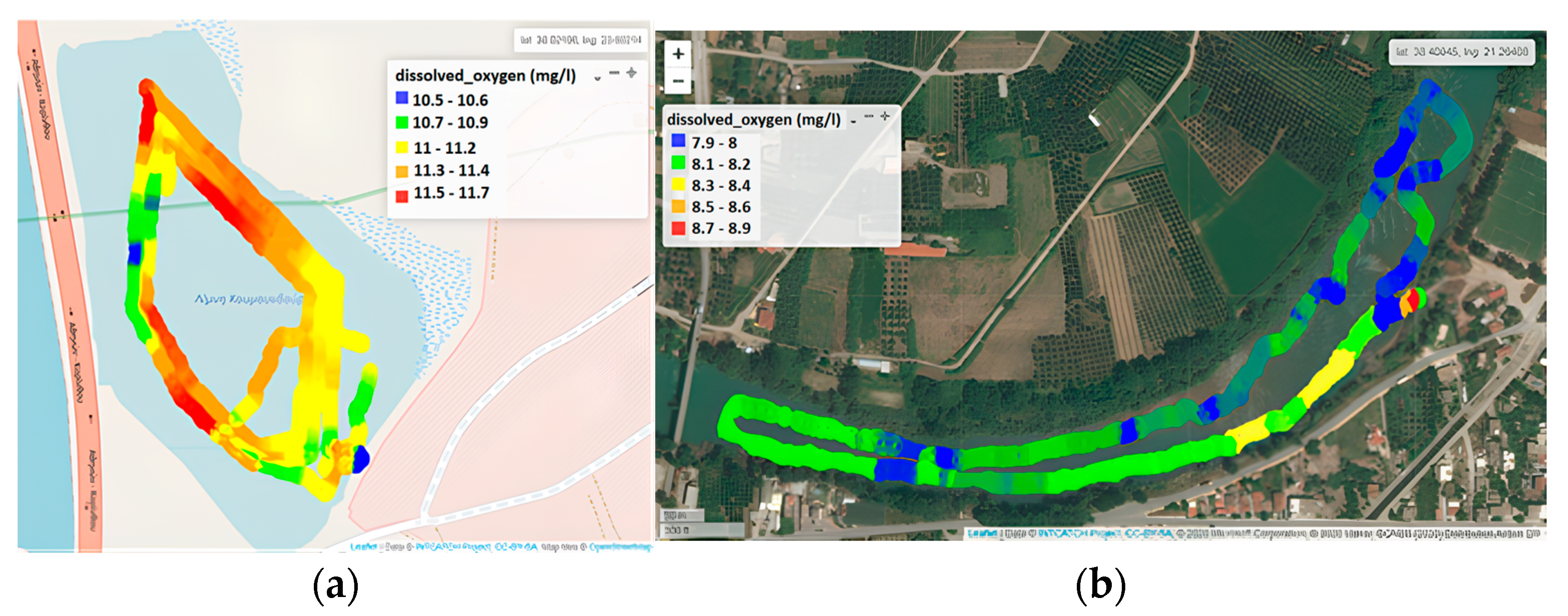
2.4.1. Koumoundourou Lake

Koumoundourou Lake is located in Western Attica. It is a lagoon with a mean depth of 1.5 m, laying upon the sea level, very close to the coasts of Elefsis Bay, and is separated from the sea by the Athens—Corinth National Highway [40]. Its water is brackish, also receiving freshwater. The lake was artificially created in antiquity when the construction of a coastal embankment blocked the passage of waters of adjacent springs towards the sea. Koumoundourou Lake has been declared as a protected archaeological site with a 50 m protection zone surrounding the lagoon (Official Journal of the Hellenic Republic 5/B/8.1.1974) and an Area of Outstanding Natural Beauty (site code: AT2011014), while it is included in MedWet wetland database (site code: GR300318000). However, its position nearby the industrial area of Skaramangas—Aspropyrgos has resulted in a highly polluted lake system. Demonstration of the ‘Chlα’ and ‘HM and Sampling’ USVs was performed in May 2019 at Koumoundourou Lake, collecting more than 30,000 datapoints of physicochemical parameters, covering almost its entire surface and three nearshore stations (demo, pumping and dam stations).

2.4.2. Acheloos River

Acheloos River is the second longest river in Greece (Figure 3). Its total length, extending from its sources in the mountains of Pindos (Mount Lamkos or Peristeri) to its estuary at the border with the Ionian Sea (west of Aetoliko-Mesolongi lagoons) is 255 km, while its total catchment area occupies a surface of 6468 km2, with a maximum altitude of 2470 m [41]. According to the typology of the rivers of Greece [42,43], the study section is classified as type R-M3 (large rivers with mixed geology and highly seasonal flow), characterized by good chemical status [44]. Upstream of the study area, three dams constituting the Acheloos hydro-system scheme have been constructed to meet irrigation, hydropower, domestic and flood control needs. In September 2019, water quality monitoring was carried out in Acheloos River using the ‘Chlα’ USV. More than 10,000 datapoints of physico-chemical parameters, along a 2.5 km route upstream and downstream the river, from the Neochori to Katochi bridge, were collected.

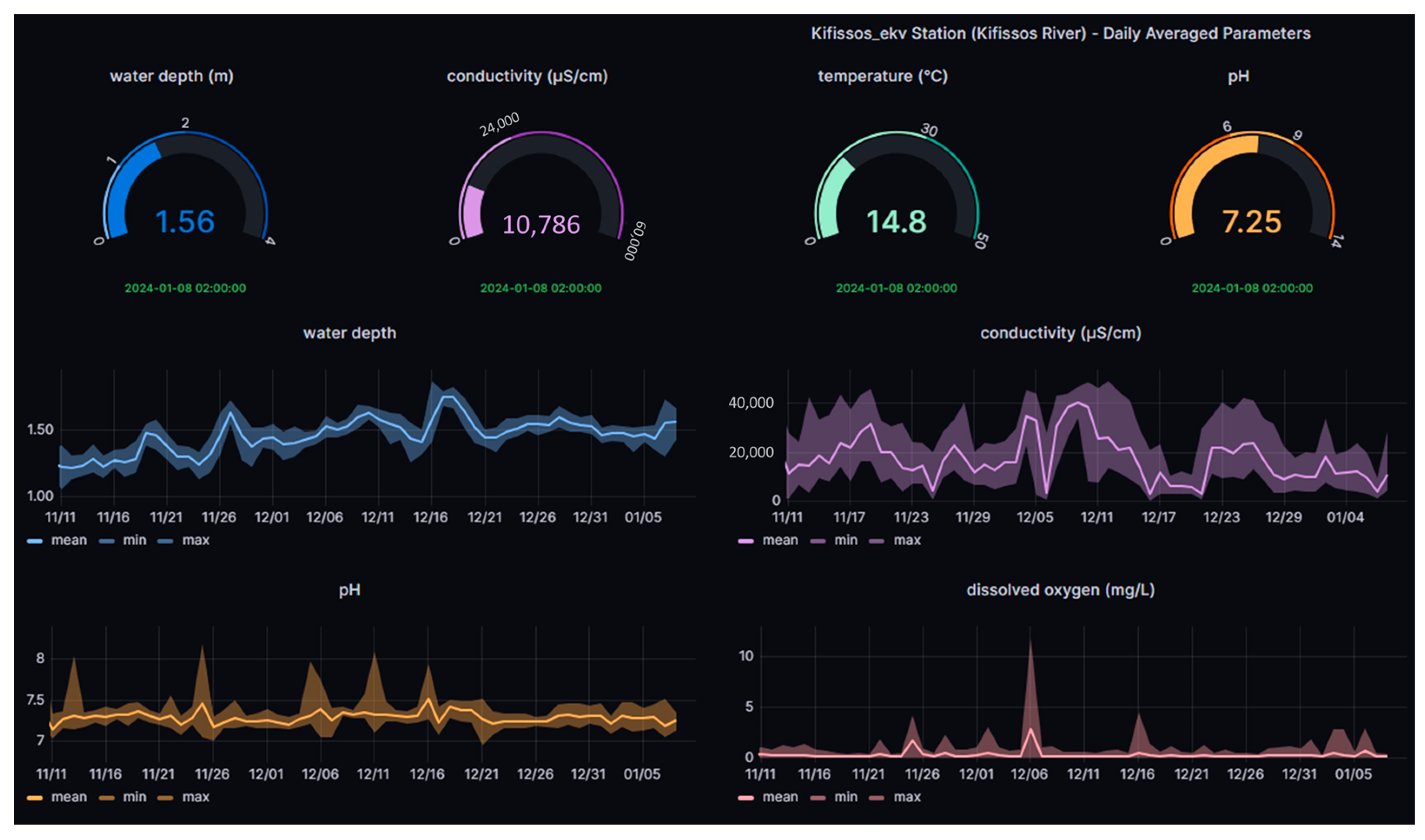
2.4.3. Kifissos River

Kifissos River is the principal river of Attica region, with its lower part flowing in parallel or below a highway, before reaching Faliro Bay within the Saronic Gulf. Kifissos is classified as river type R-M2 (medium rivers with mixed geology and highly seasonal flow), being the largest river of Attica Basin [44]. It has a length of 29 km, of which 14 km are within an urban area. Its catchment area is 420 km2, flowing through the central-western part of the Attica prefecture. The river is the main rainwater recipient of Attica. The floods that have occurred since ancient times, as well as the continuous expansion of the city limits, have led to structural interventions of the river. In July 2020, monitoring of the water quality of Kifissos River was carried out with the ‘Chlα’ USV and the research team collected approximately 15,000 datapoints of physico-chemical parameters along a 2 km stretch downstream of the river, from its mouth at Athens Marina to Piraeus Avenue (Moschato area).

2.4.4. Asopos River

Asopos is classified as river type R-M2 (medium rivers with mixed geology and highly seasonal flow), with a length of 64 km, flowing along the borders of Boeotia and Attica Prefectures [44]. It originates from the Kithaironas mountain and empties into the southern Evoikos Gulf at the coastal area of Chalkoutsi town. Within the catchment area of Asopos, populated with approximately 70,000 inhabitants, very intense industrial and agricultural activity has been developed, leading to its consideration as one of the most polluted streams of Greece. Environmental pollution in Asopos waters became known in August 2007 when measurements by the General State Laboratory and other accredited laboratories detected the presence, among others, of hexavalent chromium in the water table of the area [41,45]. Monitoring of water quality at the mouth of Asopos River in Chalkoutsi was carried out in October 2019. The ‘HM and Sampling’ USV collected data of physicochemical parameters and heavy metals (copper and lead).

2.4.5. Industrial effluents

The Metamorfosis Wastewater and Septic Sewage Treatment Plant (Metamorfosis WWTP) has been in operation since the 1980s in Greece, serving the purpose of treating both septic sewage and municipal wastewater. Situated in Athens, it holds the distinction of being the sole facility capable of receiving and treating septic sewage from areas lacking a sewerage system. This pivotal function has led to the cessation of uncontrolled sewage discharges into streams, thereby achieving a significant milestone in the protection of surface and ground waters. Two industrial effluent samples of varying origins were obtained and subjected to testing through a simulation operation conducted by the ‘HM and Sampling’ USV at the EYDAP laboratory.

3. Results and Discussion

Given the diverse nature of the study areas—comprising both a lake and multiple rivers—it is likely that the data collected from USVs and potentially integrated with telemetric stations would offer a comprehensive understanding of water quality dynamics across different water bodies. This comprehensive approach enables the identification of specific issues, trends or variations in water quality parameters across these varied environments.

3.1. ‘Chlα’ USV Campaigns for Physicochemical Parameters in Greece

3.1.1. Chlorophyll α

Chlorophyll α levels in Koumoundourou lake ranged from 10.0 to 17.5 μg L−1, being higher along the northeast part of the lake (Figure 4a), due to water circulation and groundwater influx. Regarding the Kifissos estuary, Chlα concentrations varied between 2.0 and 15 μg L−1, with an average value of 5.7 µg L−1 (Figure 4b). The significantly higher Chlα concentrations, reaching 15 μg L−1, measured upstream nearby Piraeus Avenue and the Piraeus urban railway station (Figure 4b), are attributed to organic matter accumulation during the inflow of the sea front upstream of the river bed. In the case of Acheloos river, Chlα levels ranged from 1.2 to 120 μg L−1 with a mean value of 5.2 μg L−1 (Figure 4c), significantly exceeded by the values detected downstream, nearby the Katochi bridge (120 μg L−1) and opposite to Neochori village (80 μg L−1), due to plant accumulation within river bed meanders and the formation of shallow reefs or micro-lakes.
The employment of USVs is characterized by several advantages, permitting the collection of data which cover a relatively large area, albeit within a small time scale. It therefore makes feasible the evaluation of potential trends, such as the decreasing one characterizing Chlα levels towards the Kifissos river estuary and the artificial bed close to Athens Marina, deriving through their spatial distribution. The results obtained for several parameters through USVs’ application may additionally be directly evaluated in the assessment of ecological quality, as in the case of Chlα measured herewith, which, according to the ECOFRAME system [46] classifying the ecological quality of shallow lake water, assigns Koumoundourou Lake within the “good” (11–20 μg L−1) category, aligning with earlier studies [47].
Furthermore, in previous studies [14,23], authors performed a comparative analysis of results from ‘Chlα’ USVs with satellite observations as well as with unmanned aerial vehicles (UAVs) in order to validate Chlα concentrations for another catchment in Greece (Lake Marathon). The analysis shows that the real-time results of ‘Chlα’ USVs in comparison with the evaluation of the images of the UAV and satellite observations are in accordance and can contribute to traditional monitoring programs of inland waters. In comparison with aerial and satellite observations for Chlα monitoring, ‘Chlα’ USVs offer distinct advantages. They provide real-time data transmission, enabling quick assessment and response to changes in Chlα concentrations. They also offer flexibility in data collection, especially in hard-to-reach or densely vegetated areas where aerial and satellite methods may be limited. Additionally, ‘Chlα’ USVs can cover smaller water bodies or areas with finer spatial resolution, complementing the broader coverage of aerial and satellite observations. However, aerial and satellite methods may offer wider coverage over larger areas in a shorter time frame, albeit with the need for image processing. Ultimately, the choice between USVs and aerial/satellite observations depends on factors such as the specific monitoring objectives, spatial resolution requirements and logistical considerations.

3.1.2. Electrical Conductivity

Electrical conductivity in Koumoundourou Lake ranged from 2800 to 3050 µS cm−1 (Figure 5a), with maximum values reported in the northeast, indicating a small inflow of seawater mixing through underground inlets. In the study area of the Kifissos estuary, the upper limit of 3500 μS cm−1 of the USV sensor was approached downstream of Arkadiou Street (beginning of red line), representing the IMBRIW station (Figure 5b). The EC range of 1400 to 3500 μS cm−1, reported during summer of 2000, indicated a significant inflow of the sea front, typical of brackish estuarine systems, in agreement with both recent and previous studies of the research groups of IMBRIW (HCMR) and other organizations within the specific area [47,48]. Within the studied part of the Acheloos plain, EC levels were relatively low, ranging from 281 to 336 μS cm−1 (mean value 308 μS cm−1). On the USV route from Neochori downstream to the Katochi bridge, two areas were distinguished in terms of EC, one within the range 280–299 μS cm−1, and another within 300–309 μS cm−1. Despite not being substantial, this difference is indicative of potential sensor discrimination (Figure 5c). The highest EC values measured at the shallow entry point of the USV near and upstream of Neochori (310–336 μS cm−1) are related to higher water temperature.
The assessed decreasing trend featuring EC in Koumoundourou Lake, reported by USV application, coincides with the findings recorded by HCMR studies from 1984 until today [47,49]. However, the comparison between data obtained by USVs and telemetric stations may indicate several differences, as in the case of Koumoundourou Lake, where the monitoring sensors of the telemetric station are installed close to the bottom, whereas unmanned boats operate superficially. The relatively low upper EC limit (3500 μS cm−1) of the USV sensor utilized herewith may be considered as a weakness when applied in estuarine areas, particularly during time periods of low river flow resulting in significant seawater intrusion upstream, leading to EC values reaching seawater salinity levels.

3.1.3. Dissolved Oxygen

The concentration of DO is a reliable measure of the state and sustainability of an ecosystem. It is disrupted by either natural or human activities introducing an excess of nutrients into the water, leading to phytoplankton overgrowth and to anoxic phenomena, observed at areas close to the shore or nearby the bottom, characterized by organic matter accumulation. During summer, the concentration of DO on the epilimnion remains relatively high in temperate regions, owing to intense photosynthetic activity, aided by intense sunlight and atmospheric diffusion. Complying with pertinent environmental requirements, the application of USVs permits the reliable recording of DO geographical distribution over a wide area and in real time, constituting a significant advantage, particularly for sites that are difficult to reach. It simultaneously offers the possibility of identifying potential sources of environmental pressures related to discharges and surface runoff.
In Koumoundourou Lake, DO values ranged from 10.5 to 11.7 mg L−1 (Figure 6a), indicating well-oxygenated water compared to the study area of Acheloos River (Figure 6b), where the concentration of DO was reported at lower levels, ranging between 7.9 and 8.5 mg L−1, with an average value of 8.1 mg L−1. According to the limits applied for the characterization of different water quality classes set by the French SEQ System (Système d’évaluation de la qualité de l’eau des cours d’eau/SEQ-Eau), the ecological status of a river with a DO concentration exceeding 8.0 mg L−1 is considered ‘high’. Τhe spatial distribution of DO demonstrates higher concentrations (8.3 to 8.4 mg L−1) downstream of the river, nearby Neochori, attributed mainly to higher river velocity and water agitation. Simultaneously, several point intervals are recorded, mainly upstream of the river, with the concentration of DO remaining lower than 8.0 mg L−1 (Figure 6b, blue color illustration), consumed by the degradation of accumulated organic matter and/or other biological processes.

3.1.4. pH

The pH of natural waters typically ranges between 4 and 9 units, with the range 6.5–8.5 being the most suitable for aquatic organisms. Water pH depends on various factors, including temperature, salinity (presence of sulfur anions, chlorine, cations of calcium, magnesium, etc.), carbon dioxide and oxygen levels, as well as the metabolic activity of aquatic organisms (such as photosynthesis and respiration) and organic substances’ chemical decomposition. Changes in pH are typically attributed to CO2 consumption in the epilimnion due to photosynthetic activity, resulting in a subsequent increase in pH. Recording of pH values through the application of USVs offers a significant amount of data, permitting coverage of wide areas, even remote, in both space and real time.
Within Koumoundourou Lake, pH was found to be alkaline, ranging from 8.6 to 8.7 (Figure 7a), with its spatial distribution demonstrating a slight decrease in the northeastern part, close to karst springs, attributed to fresh water inflow. According to ECOFRAME system [46], a pH range 6.0–10.0 (combined with Chlα) characterizes a ‘good quality’ system. The pH showed significant fluctuations in the study area of Kifissos River, ranging from 7.7 to 8.7 (Figure 7b), generally complying with the acceptable pH limits (6.5–8.5), except for specific high values measured. Higher pH values were determined upstream of the study area at the height of Piraeus Avenue, while a gradual decrease was observed towards the Kifissos estuary. The comparison with the corresponding values of time series recorded for the fixed station [48] of HCMR during July–August 2020 points out that pH values approximately equal to 9 appear frequently.

3.2. ‘HM and Sampling’ USV Campaigns in Greece

The ‘HM and Sampling’ USV was employed in Greece from January to October 2019, simultaneously in several demonstration activities and field campaigns. Within this framework, a fruitful collaboration was developed among EYDAP, HCMR-IMBRIW and the Laboratory of Environmental Chemistry (LEC) of the National and Kapodistrian University of Athens (NKUA), serving the perspective of contributing to the requirements of organizations and authorities for water quality, management and policy issues. The results obtained through the deployment of the HM and Sampling USV in lagoon systems and estuaries for metals measurements (in situ and in water samples) were combined (a) with those of corresponding measurements performed in natural samples obtained from the field and analyzed in the Laboratory of Environmental Chemistry of NKUA and in EYDAP laboratory, as well as (b) with relevant data previously reported both by LEC-NKUA and in pertinent literature.
Considering the lake systems examined, the values of total PbT and CuT determined herewith for Koumoundourou Lake, affected by industrial and urban activities, through the application of USVs were, respectively, equal to 6.2 and lower than 0.7 μg L−1 (Table 2). These results are comparable to those reported for the same area (PbΤ 0.038–3.49 µg L−1 and CuΤ 0.178 −3.22 µg L−1) by the Institute of Marine Biological Resources and Inland Waters of HCMR [47,49] (Table 2). Significantly higher values were previously provided for other Greek lakes [48,50,51] (Table 2), with Vistonis Lake of Northern Greece demonstrating the higher concentrations, supporting the considerable contribution of fertilizers and pesticides to PbT and CuT levels in lakes.
Regarding river systems, concentrations not exceeding 0.8 and 0.7 µg L−1 for PbT and CuT, respectively, were reported in Asopos River, affected by industrial and agricultural activities (Table 2). These results are comparable to those recently reported for the Greek rivers Acheloos [41], Louros [41] and Asopos [52], affected mainly by agricultural pressures (Table 2).
Dissolved metals present in aquatic systems form complexes with ligands deriving either from inorganic anions or dissolved organic matter, with only a small percentage of the metals remaining in the labile form, being available for detection using the SWASV method. Under this perspective, a comparison was performed among the results, obtained via applying the HM USV system, the technique of Inductively Coupled Plasma Optical Emission Spectrometry (ICP-OES) and the electrochemical method of Differential Pulse Anodic Stripping Voltammetry (DPASV), at three near shore stations of Koumoundourou Lake (demo, pumping and dam stations) (May 2019) and Asopos River estuary (October 2019) (Table 3). Field sampling was performed in parallel and the samples were analyzed by the ICP-OES method [53], in EYDAP accredited laboratory [54]. Electrochemical measurements of labile metals (PbL and CuL) were carried out in LEC-NKUA by a voltametric instrument (μ-AUTOLAB, Eco-Chemie, The Netherlands) connected to a three-electrode cell (VA 663, Metrohm stand, Switzerland), with a static mercury drop electrode (SMDE) as the working electrode, the reference electrode Ag/AgCl (3 M KCl) and a carbon rod as the auxiliary electrode. The mode of Differential Pulse Anodic Stripping Voltammetry (DPASV) was applied. Prior to the field campaigns, calibration of the screen-printed sensor was performed in the laboratory, using mixed solutions containing a 1:4 Pb:Cu ratio. For a better representation of the concentration range of the studied metals in real surface waters, the calibration solutions were first prepared within a concentration range of 19–75 µg L−1 for PbL and of 75–300 µg L−1 for CuL. The performance of the HM USV system was satisfactory considering the calibration procedure, with the measurements of real samples providing useful results subject to further discussion. Additional comparisons were carried out in two industrial effluent samples, where both Pb and Cu levels considerably exceeded those of natural samples.
The comparison of the results obtained, through the different analytical techniques applied, demonstrates the applicability of DPASV and ICP for the evaluation of the labile metal fractions and total metal concentrations, respectively. The considerable differences characterizing the results deriving for the same sampling areas employing SWASV and DPASV, applied under different experimental conditions for in situ and laboratory measurements, respectively, are attributed to the different detection window of these methods and mainly to the significantly higher LOD values of SWASV. The different working electrodes used, carbon paste screen-printed electrode (SPE) in SWASV and hanging mercury drop electrode (HMDE) in DPASV, as well as the different diffusion layers formed in each case, determine a different detection window and different limits of detection, hence imposing a detailed description of the experimental conditions applied.
The HM USV technique is so far suitable for cases of detecting point contamination by metals, rather than metal measurements in natural systems, due to a lack of sensitivity attributed to influences exerted from the water matrix and the concentration ratio of metals present. This becomes evident in the results obtained for field samples, in almost all cases of which Pb and Cu concentrations measured by SWASV were lower than the corresponding LOQs (Table 3). On the contrary, in cases of effluents samples, characterized by a particularly elevated Pb and Cu content, no significant differences are observed in Pb and Cu concentrations measured by SWASV and DPASV (Table 3). For this purpose, its sensitivity improvement, in order to respond to the low labile metal levels present in natural systems, becomes more than valuable for the direct detection of labile metal fractions in the field, avoiding any pretreatment of the samples.
The present work has set the initial basis for the application of the ‘HM and Sampling’ USV in the real time monitoring of metals. However, the significant differences featuring the results obtained for field samples with relatively low metal levels through the techniques of SWASV and DPASV denote a demand for improvement of the SWASV sensitivity and for achieving lower detection limits, in order to permit its application also to natural, unpolluted areas. Additional effort is required for the elaboration of such a perspective, which will exploit the valuable advantages for real time monitoring though direct in situ measurements, even in areas not easily accessible.

4. Conclusions

USVs enable a comprehensive and continuous monitoring approach, allowing for a detailed assessment of spatial and temporal variations. The application of two USV types was conducted to Greek catchments for the first time in the present work, clearly demonstrating their benefits in the process of water monitoring, together with their disadvantages imposing improvements in certain operational domains.
The employment of the ‘Chlα’ USV type, appropriate for the measurement of physicochemical parameters, in parallel with hydro-telemetric stations, achieves a thorough monitoring coverage both in space and real-time, providing a significantly higher amount of water quality data, even from hardly accessible sampling areas, without requiring any costly monitoring schemes. It also makes feasible the on-time raising of alerts in the attempt of elaborating action for protecting end users. The systematic, full-scale application of unmanned boats and hydro-telemetric stations could support investigative monitoring programs, representing a valid rapid tool/approach in cases of emergency (e.g., in relation to climate change events such as floods). However, since the sensors of the physicochemical parameters measured are installed close to the water surface, only data from that area are recorded, constituting a disadvantage of the USV system. In addition, the relatively low upper limit of, e.g., electrical conductivity (EC) featuring the corresponding USV sensor, requires improvement in order to become applicable to areas of naturally higher EC values such as estuaries.
Regarding the ‘HM and Sampling’ USV, it has been demonstrated that the developed and validated HM system [38] represents an innovative in-situ tool for investigative monitoring of aquatic environments, and it is considered fit-for-purpose for the detection of Cu and Pb from industrial discharges into small water body receivers and accidental pollution sources. However, certain improvements are necessary to overcome weaknesses related both to limited sensitivity and selectivity issues attributed to influences from the water matrix. The enhancement of the HM system for in situ detection of variations in the metal concentrations of surface water bodies also remain challenging to meet the limits of environmental quality standards (EQS) established by the WFD.
USVs provide real-time water quality reporting, crucial for effective decision-making and management, together with the collection of numerous discrete samples and the representative coverage of a study area (e.g., a whole lake) required for the chemical classification of a water body. Since the effectiveness of these vessels in rivers and lakes has been so far evaluated by a wide range of stakeholders involved, among others, in water quality, further development work is ongoing, aiming at enhancing sensitivity and minimizing or avoiding interferences by utilizing a fingerprinting approach. Additionally, designing USVs with enhanced environmental adaptability and user-friendly interfaces, and fostering collaboration with stakeholders for continuous feedback, are essential. Addressing these areas will help overcome existing limitations and unlock the full potential of USVs for more effective environmental management strategies.

Author Contributions

Conceptualization, G.K. and S.K.; methodology, G.K., S.K. and A.M.; software, G.K. and N.T.; validation, G.K., S.K. and E.D.; testing and operation of USVs, G.K. and N.T., sampling and analysis, G.K., N.T. and S.K.; resources, S.S.; data curation, G.K. and S.K.; writing—original draft preparation, G.K., A.S. and A.M.; writing—review and editing, S.K, S.S. and E.D.; visualization, G.K., N.T. and A.M.; supervision, M.S. All authors have read and agreed to the published version of the manuscript.

Funding

This research was funded by the EUROPEAN UNION’S HORIZON 2020 research and innovation project INTCATCH “Development and application of Novel, Integrated Tools for Monitoring and Managing Catchments” under grant agreement No 689341.

Data Availability Statement

Data are contained within the article.

Acknowledgments

The Authors would like to thank Aleko Dosi, Marina Despotidou and Giorgo Pouli for field and operation assistance as well as EYDAP’s Laboratory that is responsible for ICP-OES analyses. Georgios Katsouras would like to thank Maria Perivolari for her valuable encouragement to the completion of this work. The authors wish also to thank the four anonymous reviewers for their valuable comments which led to the significant improvement of the manuscript.

Conflicts of Interest

Author Georgios Katsouras, Stylianos Samios and Nikolaos Tsalas were employed by the company Athens Water and Sewerage Company S.A. The remaining authors declare that the research was conducted in the absence of any commercial or financial relationships that could be construed as a potential conflict of interest.

References

  1. European Commission. Commission Staff Working Document European Overview (1/2) Accompanying the document Report from the Commission to the European Parliament and the Council on the Implementation of the Water Framework Directive (2000/60/EC) River Basin Management Plans. Available online: https://publications.europa.eu/en/publication-detail/-/publication/85d9694d-d1d7-48bb9402-d6da989eb9df/language-en (accessed on 27 June 2019).
  2. Zacharias, I.; Liakou, P.; Biliani, I. A Review of the Status of Surface European Waters Twenty Years after WFD Introduction. Environ. Process. 2020, 7, 1023–1039. [Google Scholar] [CrossRef]
  3. Posthuma, L.; Zijp, M.C.; De Zwart, D.; Van de Meent, D.; Globevnik, L.; Koprivsek, M.; Focks, A.; Van Gils, J.; Birk, S. Chemical pollution imposes limitations to the ecological status of European surface waters. Sci. Rep. 2020, 10, 14825. [Google Scholar] [CrossRef] [PubMed]
  4. Choukr-Allah, R.; Ragab, R.; Clemente, R. (Eds.) Integrated Water Resources Management in the Mediterranean Region, Dialogue towards New Strategy; Springer: Berlin/Heidelberg, Germany, 2012. [Google Scholar] [CrossRef]
  5. Ganoulis, J. A New Dialectical Model of Water Security under Climate Change. Water 2023, 15, 2672. [Google Scholar] [CrossRef]
  6. Farid Ahmed, M.; Mokhtar, M.B.; Lim, C.K.; Suza, I.A.; Ayob, K.A.; Khirotdin, R.P.; Majid, N.A. Integrated River Basin Management for Sustainable Development: Time for Stronger Action. Water 2023, 15, 2497. [Google Scholar] [CrossRef]
  7. Suresh, K.; Tang, T.; Van Vliet, M.; Bierkens, M.F.; Strokal, M.; Sorger-Domenigg, F.; Wada, Y. Recent advancement in water quality indicators for eutrophication in global freshwater lakes. Environ. Res. Lett. 2023, 18, 063004. [Google Scholar] [CrossRef]
  8. Girotto, C.D.; Piadeh, F.; Bkhtiari, V.; Behzadian, K.; Chen, A.S.; Campos, L.C.; Zolgharni, M. A critical review of digital technology innovations for early warning of water-related disease outbreaks associated with climatic hazards. Int. J. Disaster Risk Reduct. 2023, 100, 104151. [Google Scholar] [CrossRef]
  9. Lekkas, T.; Kolokythas, G.; Nikolaou, A.; Kostopoulou, M.; Kotrikla, A.; Gatidou, G.; Thomaidis, N.S.; Golfinopoulos, S.; Makri, C.; Babos, D.; et al. Evaluation of the pollution of the surface waters of Greece from the priority compounds of List II, 76/464/EEC Directive, and other toxic compounds. Environ. Int. 2004, 30, 995–1007. [Google Scholar] [CrossRef] [PubMed]
  10. Katsouras, G.; Chalaris, M.; Tsalas, N.; Dosis, A.; Samios, S.; Lytras, E.; Papadopoulos, K.; Synodinou, A. Integrated ecosystem ecology (chlorophyll-a) of EYDAP′s reservoirs profiles by using robotic boats. In Proceedings of the 5th International Conference ‘Water Resources and Wetlands’, Tulca, Romania, 8–12 September 2021; pp. 202–210. Available online: http://www.limnology.ro/wrw2020/proceedings/23_Katsouras.pdf (accessed on 9 September 2021).
  11. Dokou, Z.; Kourgialas, N.; Karatzas, G.P. Assessing groundwater quality in Greece based on spatial and temporal analysis. Environ. Monit. Assess. 2015, 187, 774. [Google Scholar] [CrossRef] [PubMed]
  12. Karamanis, D.; Stamoulis, K.; Ioannides, K.; Patiris, D. Spatial and seasonal trends of natural radioactivity and heavy metals in river waters of Epirus, Macedonia and Thessalia. Desalination 2008, 224, 250–260. [Google Scholar] [CrossRef]
  13. Moustaka-Gouni, M.; Sommer, U.; Economou-Amilli, A.; Arhonditsis, G.B.; Katsiapi, M.; Papastergiadou, E.; Kormas, K.A.; Vardaka, E.; Karayanni, H.; Papadimitriou, T. Implementation of the Water Framework Directive: Lessons Learned and Future Perspectives for an Ecologically Meaningful Classification Based on Phytoplankton of the Status of Greek Lakes, Mediterranean Region. Environ. Manag. 2019, 64, 675–688. [Google Scholar] [CrossRef]
  14. De Keukelaere, L.; Moelans, R.; Knaeps, E.; Sterckx, S.; Reusen, I.; De Munck, D.; Simis, S.G.H.; Constantinescu, A.M.; Scrieciu, A.; Katsouras, G.; et al. Airborne Drones for Water Quality Mapping in Inland, Transitional and Coastal Waters—MapEO Water Data Processing and Validation. Remote Sens. 2023, 15, 1345. [Google Scholar] [CrossRef]
  15. Samarinas, N.; Spiliotopoulos, M.; Tziolas, N.; Loukas, A. Synergistic Use of Earth Observation Driven Techniques to Support the Implementation of Water Framework Directive in Europe: A Review. Remote Sens. 2023, 15, 1983. [Google Scholar] [CrossRef]
  16. Mantzouki, E.; Campbell, J.; Van Loon, E.; Visser, P.; Konstantinou, I.; Antoniou, M.; Giuliani, G.; Machado-Vieira, D.; Gurjão De Oliveira, A.; Maronić, D.Š.; et al. A European Multi Lake Survey Dataset of Environmental Variables, Phytoplankton Pigments and Cyanotoxins. Sci. Data 2018, 5, 180226. [Google Scholar] [CrossRef]
  17. Warner, W.; Nödler, K.; Farinelli, A.; Blum, J.; Licha, T. Integrated approach for innovative monitoring strategies of reservoirs and lakes. Environ. Eng. Manag. J. 2018, 17, 2497–2505. [Google Scholar] [CrossRef]
  18. Mendoza-Chok, J.; Luque, J.C.C.; Salas-Cueva, N.F.; Yanyachi, D.; Yanyachi, P.R. Hybrid Control Architecture of an Unmanned Surface Vehicle Used for Water Quality Monitoring. IEEE Access 2022, 10, 112789–112798. [Google Scholar] [CrossRef]
  19. Yang, P.; Song, C.; Chen, L.; Cui, W. Image Based River Navigation System of Catamaran USV with Image Semantic Segmentation. In Proceedings of the 2022 WRC Symposium on Advanced Robotics and Automation IEEE (WRC SARA), Beijing, China, 20–22 August 2022; pp. 147–151. [Google Scholar]
  20. Pandey, M.; Zakwan, M.; Khan, M.A.; Bhave, S. Development of scour around a circular pier and its modelling using genetic algorithm. Water Supply 2020, 20, 3358–3367. [Google Scholar] [CrossRef]
  21. Gao, K.; Gao, M.; Zhou, M.; Ma, Z. Artificial intelligence algorithms in unmanned surface vessel task assignment and path planning: A survey. Swarm Evol. Comput. 2024, 86, 101505. [Google Scholar] [CrossRef]
  22. Kita, A.; Manakos, I.; Papadopoulou, S.; Lioumbas, I.; Alagialoglou, L.; Katsiapi, M.; Christodoulou, A. Land–Water Transition Zone Monitoring in Support of Drinking Water Production. Water 2023, 15, 2596. [Google Scholar] [CrossRef]
  23. Katsouras, G.; Konstantinopoulos, S.; De Keukelaere, L.; Moelans, R.; Christodoulou, C.; Bauer, P.; Tsalas, N.; Hatzikonstantinou, P.; Lioumbas, I.; Katsiapi, M.; et al. Unmanned Vehicles combined with satellite observations as a complement tool for water quality of Lake Marathon. In Proceedings of the EuroGEO Workshop 2022, Athens, Greece, 7–9 December 2022; Available online: http://intcatch.eu/images/Katsouras_poster_EuroGEO2022_v1.pdf (accessed on 22 March 2024).
  24. Jo, W.; Hoashi, Y.; Aguilar, L.L.P.; Postigo-Malaga, M.; Garcia-Bravo, J.M.; Min, B.C. A low-cost and small USV platform for water quality monitoring. HardwareX 2019, 6, e00076. [Google Scholar] [CrossRef]
  25. Chang, H.C.; Hsu, Y.L.; Hung, S.S.; Ou, G.R.; Wu, J.R.; Hsu, C. Autonomous water quality monitoring and water surface cleaning for unmanned surface vehicle. Sensors 2021, 21, 1102. [Google Scholar] [CrossRef]
  26. Steccanella, L.; Bloisi, D.D.; Castellini, A.; Farinelli, A. Waterline and Obstacle Detection in Images from Low-Cost Autonomous Boats for Environmental Monitoring. Robot. Auton. Syst. 2020, 124, 103346. [Google Scholar] [CrossRef]
  27. Farinelli, A.; Raeissi, M.M.; Marchi, N.; Brooks, N.; Scerri, P. Interacting with Team Oriented Plans in Multi-Robot Systems. Auton. Agents Multi-Agent Syst. 2017, 31, 332–361. [Google Scholar] [CrossRef]
  28. Knutz, T. BlueGate Customization; Deliverable 7.1, INTCATCH 2020. 2020, pp. 1–16. Available online: https://ec.europa.eu/research/participants/documents/downloadPublic?documentIds=080166e5cb3ffa13&appId=PPGMS (accessed on 20 April 2024).
  29. Allabshi, R. Validation of the Integrated System(s); Deliverable 3.3, INTCATCH 2020. 2019, pp. 1–57. Available online: https://ec.europa.eu/research/participants/documents/downloadPublic?documentIds=080166e5c43504d2&appId=PPGMS (accessed on 20 April 2024).
  30. Calisi, D. Field and Laboratory and Combined Visualizers; Deliverable 7.4, INTCATCH 2020. 2019, pp. 1–30. Available online: https://ec.europa.eu/research/participants/documents/downloadPublic?documentIds=080166e5c43b6a84&appId=PPGMS (accessed on 20 April 2024).
  31. Vatitsi, K.; Ioannidou, N.; Mirli, A.; Siachalou, S.; Kagalou, I.; Latinopoulos, D.; Mallinis, G. LULC Change Effects on Environmental Quality and Ecosystem Services Using EO Data in Two Rural River Basins in Thrace, Greece. Land 2023, 12, 1140. [Google Scholar] [CrossRef]
  32. Panagopoulos, A.; Giannika, V. Study on the water resources and the opportunities for sustainable desalination & minimal/zero liquid discharge (MLD/ZLD) practices in Greece (Eastern Mediterranean). Sustain. Water Resour. Manag. 2023, 9, 106. [Google Scholar]
  33. Katsiapi, M.; Moustaka-Gouni, M.; Michaloudi, E.; Kormas, K.A. Phytoplankton and water quality in a Mediterranean drinking-water reservoir (Marathonas Reservoir, Greece). Environ. Monit. Assess 2011, 181, 563–575. [Google Scholar] [CrossRef] [PubMed]
  34. Hydro Stations. Available online: https://hydro-stations.hcmr.gr/ (accessed on 6 February 2024).
  35. Cardoso, A.C. Criteria for the Identification of Freshwaters Subject to Eutrophication: Their Use for the Implementation of the Nitrates and Urban Waste Water Treatment Directives; European Commission, Joint Research Centre, Environment Institute: Ispra, Italy, 2001. [Google Scholar]
  36. Canadian Council of Ministers of the Environment. 2017, Canadian water quality guidelines for the protection of aquatic life: CCME Water Quality Index, User’s Manual—2017 Update. In Canadian Environmental Quality Guidelines; Canadian Council of Ministers of the Environment: Winnipeg, MB, Canada, 1999. [Google Scholar]
  37. Yang, Q.; Nagar, B.; Alvarez-Diduk, R.; Balsells, M.; Farinelli, A.; Bloisi, D.; Proia, L.; Espinosa, C.; Ordeix, M.; Knutz, T.; et al. Development of a Heavy Metal Sensing Boat for Automatic Analysis in Natural Waters Utilizing Anodic Stripping Voltammetry. ACS EST Water 2021, 1, 2470–2476. [Google Scholar] [CrossRef] [PubMed]
  38. De Vito-Francesco, E.; Farinelli, A.; Yang, Q.; Nagar, B.; Álvarez, R.; Merkoçi, A.; Knutz, T.; Haider, A.; Stach, W.; Ziegenbalg, F.; et al. An Innovative Autonomous Robotic System for On-Site Detection of Heavy Metal Pollution Plumes in Surface Water. Environ. Monit. Assess 2022, 194, 122. [Google Scholar] [CrossRef]
  39. EU. Directive 2013/39/EU of the European Parliament and of the Council of 12 August 2013 Amending Directives 2000/60/EC and 2008/105/EC as Regards Priority Substances in the Field of Water Policy Text with EEA Relevance: WFD; EU: Maastricht, The Netherlands, 2013. [Google Scholar]
  40. Roussakis, G. Chapter 2: Bathymetry of Koumoundourou Lake. In Monitoring of Groundwater Quality, Koumoundourou Lake and the Adjacent Sea Area in Relation to the Landfill of the Western Part of Attica Region; Pavlidou, A., Ed.; Intermediate Study; Hellenic Centre for Marine Research: Anavyssos, Greece, 2003; pp. 18–23. (In Greek) [Google Scholar]
  41. Skoulikidis, N.; Dimitriou, E.; Karaouzas, I. (Eds.) The Rivers of Greece. Evolution, Current Status and Perspectives. In The Handbook of Environmental Chemistry 59; Springer: Berlin/Heidelberg, Germany, 2018. [Google Scholar] [CrossRef]
  42. European Communities. Water Framework Directive Intercalibration Technical Report. Part 1: Rivers. Van de Bund; Wouter: Luxembourg, 2009. [Google Scholar]
  43. Lazaridou, M.; Ntislidou, C.; Karaouzas, I.; Skoulikidis, N. Harmonisation of a New Assessment Method for Estimating the Ecological Quality Status of Greek Running Waters. Ecol. Indic. 2018, 84, 683–694. [Google Scholar] [CrossRef]
  44. Ministry of Environment and Energy. 2nd Update of the River Basin Management Plans of River Basin District of Western Central Greece. Characterization, Typology, Reference Conditions and Evaluation/Classification of All Surface Waterbodies. 2023; (In Greek). Available online: https://wfdver.ypeka.gr/wp-content/uploads/2023/12/EL04_2REV_P4.2_Taxinomisi-EYS.pdf (accessed on 20 April 2024).
  45. General Chemical State Laboratory|IAPR. Available online: https://www.aade.gr/gcsl (accessed on 15 January 2024).
  46. Moss, B.; Stephen, D.; Alvarez, C.; Becares, E.; Bund, W.V.D.; Collings, S.E.; Donk, E.V.; Eyto, E.D.; Feldmann, T.; Fernández-Aláez, C.; et al. The Determination of Ecological Status in Shallow Lakes—A Tested System (ECOFRAME) for Implementation of the European Water Framework Directive. Aquat. Conserv. Mar. Freshw. Ecosyst. 2003, 13, 507–549. [Google Scholar] [CrossRef]
  47. Dimitriou, E.; Mentzafou, A.; Zogaris, S.; Koutsikos, N.; Kolombari, E.; Markogianni, V.; Karaouzas, I.; Konstantinopoulou, A.; Stathopoulou, E.; Dasenakis, M.; et al. Monitoring the Ecological Quality of Lake Koumoundourou and Planning Actions for Management, Restoration and Promotion (in Greek); Final Technical Report; IMBRIW-HCMR: Anavyssos, Greece, 2012. [Google Scholar]
  48. Open ELIoT. Available online: https://www.openeliot.com/en/ (accessed on 6 February 2024).
  49. Kousouris, T. Lakes in Greece, 5/6 West Greece (in Greek); Athens, Greece. 2014, pp. 1–156. Available online: https://www.ekke.gr/projects/estia/Cooper/limnes/5_book.pdf (accessed on 20 April 2024).
  50. Zacharias, I.; Bertachas, I.; Skoulikidis, N.; Koussouris, T. Greek Lakes: Limnological Overview. Lakes Reserv. 2002, 7, 55–62. [Google Scholar] [CrossRef]
  51. Farmaki, E.G.; Thomaidis, N.S. Current status of the metal pollution of the environment of Greece—A review. Glob. Nest. Int. J. 2008, 10, 366–375. [Google Scholar]
  52. Botsou, F. Study on the Impact of Ephemeral Rivers to the Coastal Marine Environment: The Case of Asopos River. Ph.D. Thesis, Chemical Oceanography, Faculty of Chemistry, University of Athens, Athens, Greece, 2007. (In Greek). [Google Scholar]
  53. ISO 11885:2007; Water Quality-Determination of Selected Elements by Inductively Coupled Plasma Optical Emission Spectrometry (ICP-OES). International Organization for Standardization: Geneva, Switzerland, 2007.
  54. ISO/IEC 17025:2017; General Requirements for the Competence of Testing and Calibration Laboratories. International Organization for Standardization: Geneva, Switzerland, 2018.
Figure 1. Two prototype USVs: (a) Chlα and (b) HM and Sampling, both equipped with the basic sensor Kit (DO, T, pH and EC).
Sensors 24 02809 g001
Figure 2. Dynamic real-time visualization platform.
Sensors 24 02809 g002
Figure 3. Study areas in Greece with the use of USVs.
Sensors 24 02809 g003
Figure 4. Chlα by the Waquin application of INTCATCH in (a) Koumoundourou Lake, (b) Kifissos river and (c) Acheloos river.
Sensors 24 02809 g004
Figure 5. Electrical conductivity by the Waquin application of INTCATCH in (a) Koumoundourou Lake, (b) Kifissos river and (c) Acheloos river.
Sensors 24 02809 g005
Figure 6. Dissolved Oxygen by the Waquin application of INTCATCH in (a) Koumoundourou Lake and (b) Acheloos river.
Sensors 24 02809 g006
Figure 7. pH by the Waquin application of INTCATCH in (a) Koumoundourou Lake, (b) Kifissos river.
Sensors 24 02809 g007
Table 1. Automatic telemetric stations of IMBRIW-HCMR.
StationLatitude/LongitudeAltitude (m)Installation DateWebsite
Koumoundourou lake38.0235° N/23.6018° E0.8328 March 2011http://t.ly/p85TU (accessed on 20 April 2024)
Kifissos estuaries37.9472° N/23.6727° E3.3515 July 2020http://t.ly/UASuZ (accessed on 20 April 2024)
Table 2. Total dissolved lead (PbT) and copper (CuT) in Greek aquatic systems reported in literature.
Fresh Water SystemActivityPbT (µg L−1)CuT (µg L−1)Source
LAKES
Koumoundourou Industrial/Urban6.2<0.7Present Study
EYDAP (ICP-OES)
0.038–3.490.178–3.22Dimitriou, 2012 [47]
Koussouris, 2014 [49]
VegoritisFertilizer/pesticide1.2–24.20.7–15.2Zacharias, 2002 [50]
Mikri Prespa0.214.4
Koronia36.83.7–21.8
Vistonis58.443.2
Kastoria31.16.6–19.4
Doirani22.39.6–12.4
RIVERS
AsoposIndustrial/Agricultural<0.8<0.7Present Study
EYDAP (ICP-OES)
AcheloosAgricultural0.07–2.850.01–5.40Skoulikidis, 2018 [41]
LourosAgricultural/Urban0.05–0.480.24–0.60
AsoposIndustrial/Agricultural0.120–1.420.350–3.25Botsou, 2007 [52]
Table 3. Comparison of results obtained by the SWASV method (HM USV), DPASV method (LEC, NKUA) and ICP-OES method (EYDAP) for total and labile PbL and CuL, for Lake Koumoundourou (02/07/19), Asopos River and industrial effluents samples. Values in parentheses are <LOQ.
Metal1PbL
(µg L−1)
2PbL
(µg L−1)
3PbT
(µg L−1)
4CuL
(µg L−1)
5CuL
(µg L−1)
6CuT
(µg L−1)
Sample Name/MethodHM USV
(SWASV)
LEC
(DPASV)
EYDAP
(ICP-OES)
HM USV
(SWASV)
LEC
(DPASV)
EYDAP
(ICP-OES)
Demo station
Lake Koumoundourou
(8.1)0.5<0.8(13)0.8–1.0<0.7
(12)(7.8)
16(8.8)
Pumping station
Lake Koumoundourou
18<0.16.2(18)<0.1<0.7
(8.5)<7
2027
Dam station
Lake Koumoundourou
(12)<0.1<0.8<7<0.1<0.7
(8.1)
<4
Asopos River Estuary(10)<0.1<0.8<70.8–1.0<0.7
(7.6)<7
(10.8)(13)
(10.4)<7
Effluent 15449864137120
Effluent 271651166260185
1HM USVPb LOD = 4 μg L−1; 2DPASVPb LOD = 0.1 μg L−1; 3ICP-OESPb LOD = 0.8 μg L−1; 4HM USVCu LOD = 7 μg L−1; 5DPASVCu LOD = 0.1 μg L−1; 6ICP-OESCu LOD = 0.7 μg L−1.
Disclaimer/Publisher’s Note: The statements, opinions and data contained in all publications are solely those of the individual author(s) and contributor(s) and not of MDPI and/or the editor(s). MDPI and/or the editor(s) disclaim responsibility for any injury to people or property resulting from any ideas, methods, instructions or products referred to in the content.

