Article

Opportunistic Weather Sensing by Smart City Wireless Communication Networks

School of Electrical Engineering, Tel Aviv University, P.O. Box 39040, Tel Aviv 6997801, Israel
*
Author to whom correspondence should be addressed.
Sensors 2024, 24(24), 7901; https://doi.org/10.3390/s24247901
Submission received: 30 October 2024 / Revised: 1 December 2024 / Accepted: 5 December 2024 / Published: 11 December 2024
(This article belongs to the Special Issue Wireless Sensor Networks and IoT for Smart City)

Abstract

:
This paper presents how the concept of opportunistic integrated sensing and communication (ISAC), focusing on weather sensing, is incorporated into wireless smart cities’ networks. The concept, first introduced in 2006, utilized standard signal level measurements from wireless backhaul cellular networks for rain monitoring. Since then, it has expanded to include technologies like satellite communication and smart cities’ networks. Opportunistic ISAC (OISAC) for weather involves transforming communication networks into virtual sensors by interpreting the signal attenuation caused by environmental factors, such as rain. These virtual sensors form the sensing layer of an IoT system, with built-in connectivity. In this paper, we present the recent advancements in the field, emphasizing the potential of current and future smart cities’ wireless networks for accurate rainfall monitoring. We also demonstrate a test case in the city of Rehovot in Israel, where high spatiotemporal resolution rain maps produced via the OISAC paradigm significantly outperform the spatial resolution achieved by modern weather radars. We also discuss the challenges and opportunities in applying this concept.

1. Introduction—Opportunistic Sensing of Weather

Weather monitoring, especially for precipitation, is crucial for modern applications like forecasting, water management, and smart city development. It also plays a role in understanding global phenomena like climate change and renewable energy potential. Within an urban environment, accurate rainfall monitoring is especially important for water management such as flash in-city flood prevention, and to help urban planners and engineers use rainfall information both to design efficient city infrastructure and better manage and control the city during extreme weather events scenarios. Traditional weather monitoring tools, such as rain gauges and weather stations, are precise but offer limited spatial coverage, while remote sensing technologies like satellites and radars provide wider coverage but are less accurate near the ground [1,2]. Moreover, the temporal resolution of remote sensing measurements is limited. Furthermore, installing and maintaining these systems is expensive and typically limited to developed countries, leaving regions such as Africa, Central Asia, and South America with poor or non-existing coverage. On the other hand, technological advancements use the atmosphere, and, in particular, the near-the-surface atmosphere, as a home for human-made electromagnetic radiation, for military and civilian uses. A few examples are radio transmission, cellular communication, satellite TV, and navigation systems. Nowadays, the electromagnetic spectrum is so crowded that in any given time and almost all around the globe, technology induced electromagnetic waves are present [3]. Naturally, the electromagnetic signals, traveling in the atmosphere in different frequencies, layers, and locations, carry information about the media they go through [4].
The idea of leveraging existing communication technologies for environmental monitoring, i.e., in an opportunistic use, is a relatively new and viable solution to improve environmental monitoring capabilities, as dedicated meteorological sensor network deployment involves high costs and expensive maintenance [5]. In [6], the Global Positioning System (GPS) was first used for water vapor sensing. Later, in 2006, it was first shown how commercial cellular backhaul networks can be used for rain monitoring [7,8,9]. This idea is based on utilizing the already deployed existing commercial wireless communication networks, and, in particular, commercial microwave and mmWave links (CMLs)—usually operating at frequencies above 6 GHz—for precipitation monitoring. The number of CMLs worldwide is immense (in order of millions of CMLs), and thus, adding this approach to the arsenal of weather monitoring can vastly help in reducing the need to deploy and maintain dedicated meteorological sensors. Specifically, in locations where dedicated meteorological equipment is lacking (e.g., Africa), cellular coverage indeed exists [10,11,12], further helping close the gap in the world-wide coverage of weather sensing.
In recent years, the concept of integrated sensing and communication (ISAC) started to gain interest as the next generation leading technology [13]. It was recently presented how high-frequency E-band-based CMLs can be used to monitor rain in urban environments [14,15] where traditional weather monitoring techniques often fail. The potential for weather opportunistic monitoring is further enhanced as future networks—and especially in urban environments—will become more diverse and include many line-of-sight microwave and mmWave links, all part of an xhaul mesh (combining the “classic” backhaul and fronthaul of wireless communication networks) that becomes a necessity for the modern city [16].
The ISAC (also known as joint communication and sensing—JCAS) paradigm aims at future technologies designed to optimally use the spectrum for both communication and sensing applications. It states that sensing capabilities (such as dedicated sensors) can be implemented as part of wireless communication nodes, and thus, combined equipment capable of both communication and sensing can be developed and deployed (e.g., wireless communication terminals with on-board temperature sensors) [17,18]. OISAC, on the other hand, is based on existing technologies, where the sensing function is added to communication (or vice versa). In our case, we utilize the wireless communication channel itself to sense the environment—especially the weather—opportunistically.
As stated, tens of research groups around the world have reported that CMLs as well as satellite microwave links (SMLs) are capable of accurately monitoring rain and other weather phenomena such as fog, humidity, and dew in many parts of the world (see [7,8,9,10,12,15,19,20,21,22,23] among many others), all falling into the definition of OISAC since it uses existing communication for sensing. In the following sections, we begin by reviewing the current state of OISAC for weather, especially detailing the use of CMLs, and the CMLs deployed in a dedicated installment for smart cities’ wireless networks (SCWNs). We then discuss and demonstrate the feasibility of using actual measurements for the potential of OISAC in smart city environments where SCWNs are integrated parts of every modern smart-city infrastructure. Lastly, we conclude this paper and discuss future directions and possibilities.

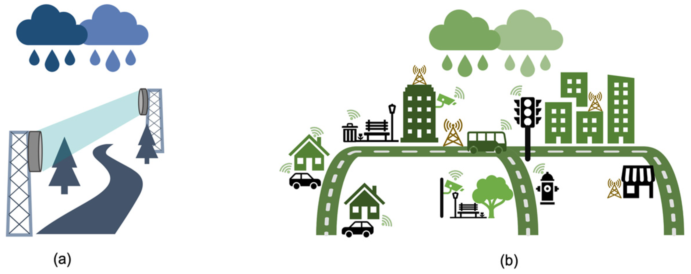
2. OISAC of Weather—Current Situation

In recent years, many researchers in universities, in state-wise meteorological services, and in the private sector, dealt with different aspects of OISAC for weather; see, for example, EU COST Action OpenSense (https://opensenseaction.eu/, accessed on 25 September 2024), connecting more than 150 members from over 30 countries. When dealing with terrestrial communications, one can divide the communication into two groups: terrestrial CMLs used mainly in backhaul cellular networks, and SCWNs—for dense smart city connectivity. It is worth noting here that satellite communication usage for OISAC is also an evolving field [19,24,25]; however, in this paper we focus on near-ground weather monitoring. In Figure 1, we present an illustration of these two main groups, which emphasize their different deployment and application properties. Note that the division of these groups can be somewhat mixed, as in recent applications, especially under the IoT framework (and IoT in smart cities specifically), different technologies work in harmony as additional parts of a full SCWN, adding a diversity of opportunistic sensor-types, but on the other hand, introducing the challenges of working with different data-sources and devices, each with its own characteristics.
In general, an IoT framework consists of three layers [26,27,28]: The perception (or sensing) layer, the communication (or the connectivity) layer, and the processing (or the data) layer. In the ISAC paradigm for IoT, the sensing capabilities (which corresponds to the end-user hardware itself, such as the transmitted/receiver modules, e.g., with additional hardware aimed for sensing phenomena of interest) are integrated with the communication layer (for further background details regarding OISAC and IoT, the reader is referred to Supplementary Materials).
The OISAC approach is used to add the sensing of the weather to the existing communication layer. In smart cities, where a vast number of connected devices are available, the number of channels is high, which raises the potential for high spatiotemporal weather products (such as rain-field maps [14,29]).
We focus on wireless communication in the microwave and mmWave frequency bands (i.e., 5 GHz to 100 GHz), as the signal level in these frequencies is more affected by weather, as shown in Figure 2. Luckily, this frequency range is the one used mainly in the backhaul CMLs and also in modern fronthaul and xhaul CMLs and SCWNs.

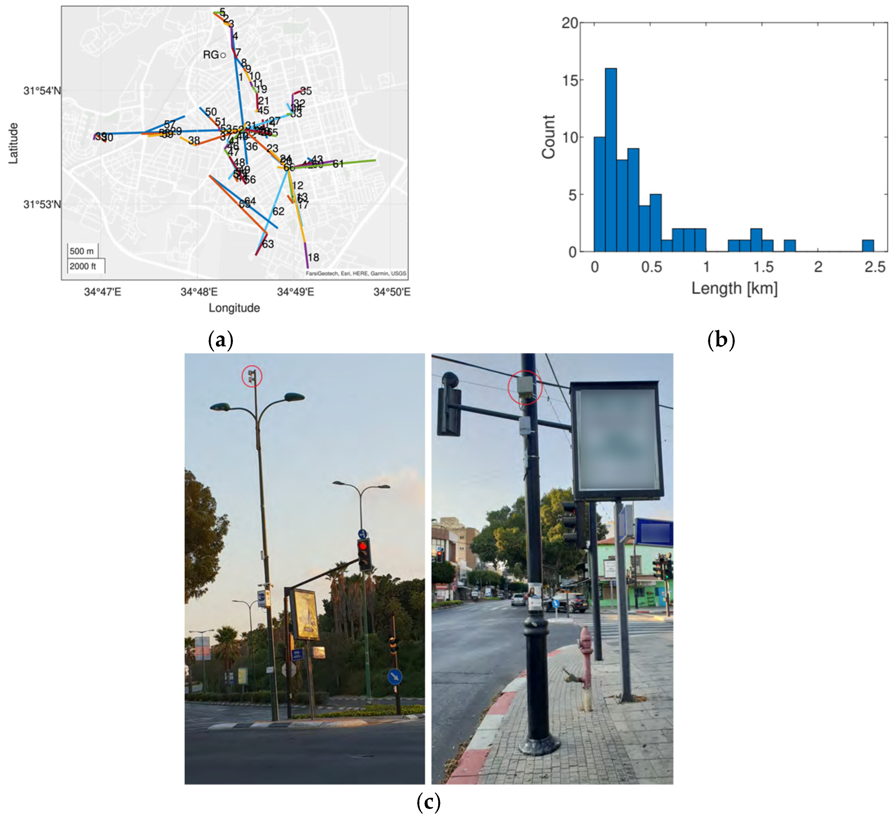
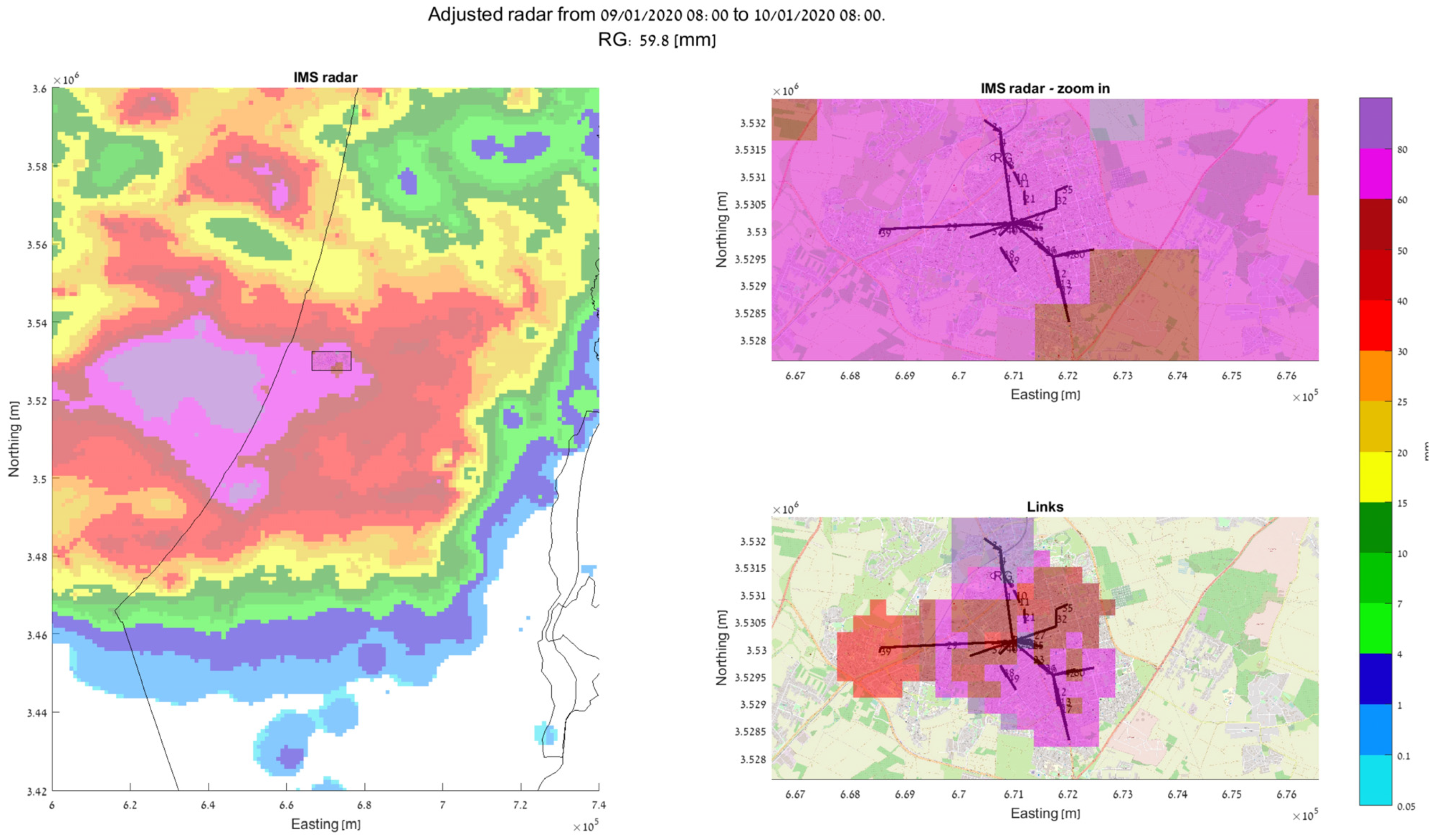
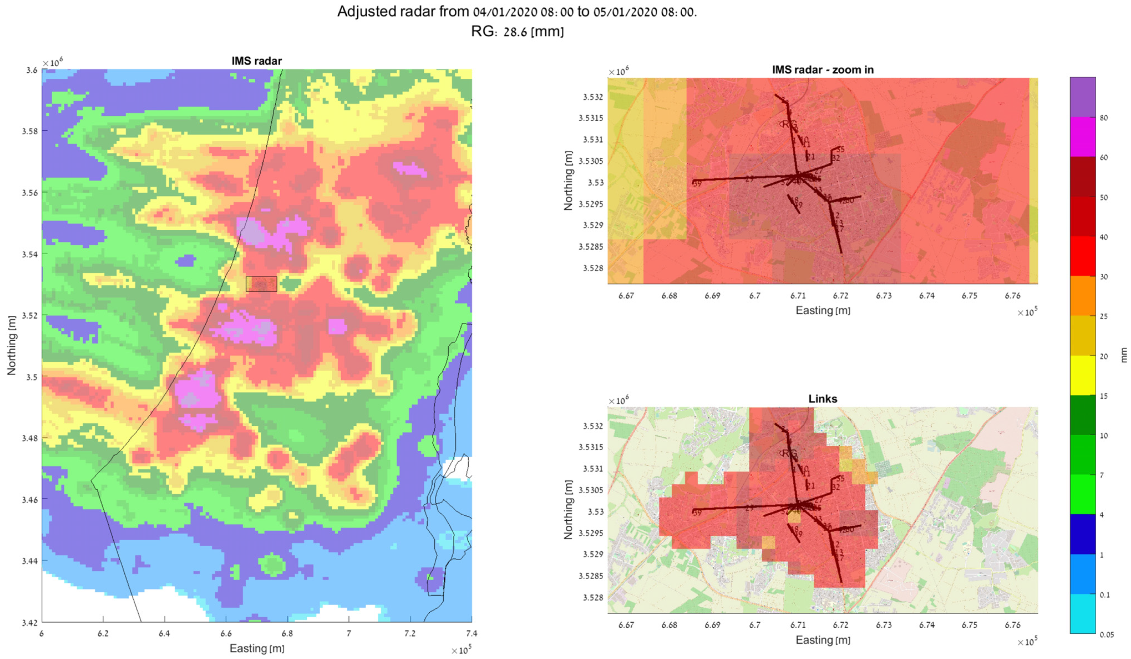
3. OISAC in Smart Cities

Smart cities have come a long way in terms of infrastructure in recent years. Current and future smart cities rely heavily on wireless communication channels operating at mmWave frequencies and, as such, can be utilized as opportunistic weather sensors. Anything from low-power communication devices (such as sensor reporting and utilizing services for citizens and the management of the city, e.g., full trash cans, bus arrivals, traffic light statuses, etc.), to high-bandwidth communication links for autonomous vehicles and street cameras are all interconnected in a vast xhaul line-of-sight grid. Future mobile devices (5G and above) will also implement mmWave modems, giving even more diversity of channels in dense connected urban environments.
Until a few years ago, CML networks were mainly used for the purpose of establishing a stable and static backhaul of cellular networks and indeed, 3G and 4G cellular networks rely heavily on such CMLs at frequencies in the K-band (6–40 GHz). In recent years, as the need for a larger bandwidth arose, higher frequencies in the E-band wireless links started to be deployed. Moreover, such E-band CMLs offer a higher throughput, and thus, are a good solution for the city-wide networks used for designated smart-city applications such as street camera feeds, public transportation real-time control, Wi-Fi services to the residents, etc. As the carrier frequency increases, it is obvious that E-band links’ capacity is higher than K-band links, but at the cost of higher propagation losses of the signal. Therefore, E-band CMLs are generally shorter—a fact that by itself introduces additional challenges for opportunistic rain monitoring—from additional non-negligible other-than-rain attenuation phenomena such as wet-antenna effects [49,50] through the general phenomena of overestimation of the rain intensity when using the standard power law (of Equation (1)) [29]. On the other hand, these frequencies are more sensitive to precipitation (See Figure 2). Recent studies showed, however, that SCWN can be exploited for opportunistically generating rain measurements that, in turn, lead to accurate near ground spatiotemporal rain maps [51]. It can also be used for the near-real time estimation of storm front movement [52], a capability that is of the utmost important for real-time city management and security service responses, especially during heavy and extreme weather events in cities.
Based on our recent works [14,53], we present a demonstration of how using signal-level measurements from an actual SCWN improves the spatiotemporal resolution of rain monitoring in urban environment significantly. In Figure 3a, a setup of an actual SCWN in the city of Rehovot in the central district of Israel is depicted. There, a total of 66 links at frequencies of 70 GHz to 80 GHz are deployed at an area of about 10 km × 10 km. The shortest link in this network has a length of only 53 m, and the longest one spans over 2.4 km [53]. A histogram of all the SCWNs’ path lengths is depicted in Figure 3b [53], and an image of the actual Tx/Rx terminals is presented in Figure 3c (taken from [54]). The full hardware description of the terminals is available in [54]. Overall, most of the links are shorter than 1 km. As the power law (of Equation (1)) was empirically proven to be problematic in terms of its accurate rain intensity estimation when dealing with short links [55], we performed a calibration of the power law, by using the longest available link as a calibration reference [29] (as longer links are not affected by the short-link inaccuracy of the power law). In Figure 4, Figure 5 and Figure 6, the full estimation workflow’s results are presented, during three days in which rain occurred—a heavy rain event (59.8 mm within 24 h), a moderate rain event (28.6 mm within 24 h), and a light rain event (3.9 mm within 24 h). In each of these figures, on the left, one can see the 24 h accumulated rainfall (in mm) as was reported by the Israeli Meteorological Services (IMS) radar, with a zoomed-in section of the map—of the city of Rehovot—depicted on the top right of the figure. At the bottom right corner of the figure, one can see the same map of accumulated rain—as was estimated by the proposed approach from signal level measurements in the SCWN. As one can see, the spatial resolution reported from the SCWN was higher than the resolution achieved by the radar by an order of magnitude: the radar spatial resolution in this scenario was 1 km by 1 km (based on the IMS radar data), whereas the SCWN produced a snapshot with a spatial resolution of roughly 300 m by 300 m. This high resolution will help smart cities’ management systems in the future to better operate their cities—including water management, risk assessment, public and private transportation needs during and after weather events, electricity distribution in a smart-grid, etc. It is also worth mentioning that whereas the radar produces a single map once every 5 to 15 min (a standard value range for weather radars world-wide), the links produce a channel attenuation value every 30 s. That is, the temporal resolution of the SCWN-based rain products are also higher by an order of magnitude when compared to the standard weather radar, opening the options for actual real-time weather-influenced city management.

4. Open Issues in Opportunistic ISAC and IoT

4.1. Non-Attenuation Measurements

Currently, the overwhelming majority of OISAC for weather is based on the measured signal level in wireless microwave and mmWave channels. Different from the traditional IoT concept, in which designated sensors are connected by wireless systems in order to allow for weather monitoring [56,57,58], the concept of OISAC is to use the already available measurements that are being collected for communication purposes, without the burden of requiring any additional hardware. As long as the signal’s Tx and Rx (or Es/No when dealing with satellite terminals) values were the main standard measured values (either instantaneous, average, or minimum and maximum values per specific time intervals), extracting weather information from such measurements was the main challenge.
Emerging wireless technologies of both CMLs and SCWNs will divert from the classic “division” of backhaul and fronthaul. For example, integrated access and backhaul [59] allows the use of phased array antenna modules to either communicate with mobile devices, or to create, in real-time, an ad hoc backhaul channel between two (or more) modules, in order to enhance the wireless network where needed (e.g., during sport events where a specific location requires additional bandwidth capabilities, or during a malfunction or unavailability of a network node that creates the need for diversion of the data around it). Such antenna arrays, as well as other capacity enhancement technologies such as MIMO cannot be controlled and managed via the attenuation values alone. Thus, future devices that build such xhaul wireless networks will report additional information such as the full channel modulation phase between different antennas in the array regularly, and the latency between the transmitted signal and the received one, which hold additional information that can be exploited for opportunistic weather monitoring purposes (e.g., [60,61]). Furthermore, to enhance the network redundancy, some hardware manufacturers propose a multi-band [62] approach, in which a number of CMLs share the same path using different frequencies, increasing the amount of the available data and its diversity. The use of additional information can be explored and exploited, as such data have already been shown to include additional information about the weather. In a way, it can be viewed as analogous to the optical readings made by a disdrometer, capable of reporting the type of fallen precipitation and the drop size distribution with high accuracy using a set of light emitting diodes or lasers diodes to create an optical plate passing through the air and used to detect precipitation particles [63]. In addition, the number of available transmitters and receivers is expected to increase exponentially, as 5G and xhaul SCWNs will penetrate our daily lives [64,65].
Looking back at Figure 1b, an illustration of future SCWNs can be seen. This features a futuristic IoT network including many devices, all connected by mmWave signals: bus stops, trash cans, electric vehicles charging stations, etc. As future smart cities will rely on heavy IoT connected devices [65,66], the number of available OISAC data sources is almost limitless. All the data about the signal quality of such devices (or even more primitively, the connection status of such devices, which can inform us about “good/bad channel properties”) can be processed either at the edge, or in a centralized location. Furthermore, the all-time connectivity of the devices in the new smart city scape could be implemented further, as recently shown in [67], where air temperature trends were extracted from smartphones built in sensors data.

4.2. Wireless Networks Quality of Service Optimization

Up to this point, we presented how OISAC can be used for weather monitoring, specifically, in the smart-city scene. However, one can think in the opposite direction, using opportunistic sensitivity to improve communication. As weather phenomena influence the performance of communication networks, and since CMLs and SCWNs report attenuation (and other signal-based data) back for network management purposes, it is possible to add an additional layer of processing, which could detect disturbances in the network throughput in real-time or near real-time, and use these disturbances to predict future disturbances. In a recent work [68], we presented how one can detect such disturbances (caused by a storm) and predict these disturbances due to the storm movement up to a few minutes ahead of time. Such predictions can make the network management proactive (e.g., by changing the network switching and rerouting profiles ahead of time), and thus, improve the quality of service (QoS) of the network dramatically.

5. Summary and Conclusions

High temporal–spatial resolution weather monitoring on the ground level is essential for many human applications. Within an urban environment, accurate rainfall monitoring is especially important both for smart city planning and for its operation.
Such high-resolution monitoring can be achieved by a dense network of designated sensors. Such a solution, however, is unrealistic because of practical deployment and maintenance challenges. Moreover, because of the local climate created in cities, remote sensing techniques for weather monitoring are less effective in urban areas [69]. In this paper, we presented the paradigm of using opportunistic sensing of the weather using the wireless communication infrastructure that is present in modern smart cities’ infrastructure. The idea is to use the already available hardware that produces standard attenuation measurements in SCWN as virtual weather monitoring devices. As such, they can be viewed as OISAC devices with no (or negligible) additional cost. The performance of the weather products depends on the availability of sensors and their spread. Naturally, the density of the virtual sensors is proportional to the density of the population in a given area. Here, smart cities provide a win–win situation, as the denser the population is, the higher the number of microwave and mmWave-connected devices are available. As a demonstration in the city of Rehovot in Israel, a rainfall map with a spatial resolution of an order of magnitude higher than the standard weather radar has been achieved.
Lastly, we emphasize that OISAC is not only confined to rain monitoring. Indeed, monitoring different weather phenomena poses additional challenges, but past studies established the potential of using CMLs for not only near-ground rain mapping (e.g., [22,70]), but also for many other weather phenomena [71]. Thus, we conclude with emphasizing that the concept of OISAC should be integrated into the design and management phases of modern smart cities, as it has the potential to benefit them greatly.

Supplementary Materials

Part of the ideas presented in this paper are described in the IEEE ISAC FOCUS newsletter (Issue 6, 2023) online at https://isac.committees.comsoc.org/wp-content/uploads/sites/147/2023/05/ISAC-Focus_Issue6_0520.pdf (accessed on 25 September 2024).

Author Contributions

Conceptualization, J.O. and H.M.; methodology, J.O. and H.M. writing—draft, J.O.; writing—editing, J.O. writing—review, H.M.; visualization, J.O. All authors have read and agreed to the published version of the manuscript.

Funding

This research received no external funding.

Institutional Review Board Statement

Not applicable.

Informed Consent Statement

Not applicable.

Data Availability Statement

Data are contained within the article and supplementary materials.

Acknowledgments

We would like to thank our team members of the CellEnMon Lab (https://cellenmonlab.tau.ac.il/, accessed on 25 September 2024) at Tel Aviv University, and especially Mor Hadar for providing us with images of Rehovot, and Roy Janco, for providing us with the urban rainfall maps, based on the SCWN data collected by SMBIT Ltd. and provided to us by Yoav Ludmer. We also thank our long-time partners at CELLCOM Ltd., PHI-Networks, Pelephone Ltd., and Ericsson AB., for providing us with CMLs and SMLs. Without their cooperation, our research could not have been completed. This article is related to the work of COST Action OpenSense https://opensenseaction.eu/, CA20136, supported by COST (European Cooperation in Science and Technology, www.cost.eu).

Conflicts of Interest

The authors declare no conflicts of interest.

References

  1. Barrett, E.C.; Beaumont, M.J. Satellite rainfall monitoring for agrometeorology: Operational problems, practices and prospects. EARSeL Adv. Remote Sens. 1993, 2, 66–72. [Google Scholar]
  2. Raghavan, S. Radar Meteorology; Springer Science & Business Media: Berlin/Heidelberg, Germany, 2003. [Google Scholar]
  3. Levin, H.J. The Invisible Resource: Use and Regulation of the Radio Spectrum; RFF Press: Washington, WA, USA, 2011. [Google Scholar]
  4. Frey, T.L. The Effects of the Atmosphere and Weather on the Performance of a mm-Wave Communication Link. Appl. Microw. Wirel. 1999, 11, 76–81. [Google Scholar]
  5. Corke, P.; Wark, T.; Jurdak, R.; Hu, W.; Valencia, P.; Moore, D. Environmental wireless sensor networks. Proc. IEEE 2010, 98, 1903–1917. [Google Scholar] [CrossRef]
  6. Bevis, M.; Businger, S.; Herring, T.A.; Rocken, C.; Anthes, R.A.; Ware, R.H. GPS meteorology—Remote sensing of atmospheric water vapor using the Global Positioning System. J. Geophys. Res. 1992, 97, 15787–15801. [Google Scholar] [CrossRef]
  7. Messer, H.; Zinevich, A.; Alpert, P. Environmental monitoring by wireless communication networks. Science 2006, 312, 713. [Google Scholar] [CrossRef]
  8. Messer, H. Rainfall Monitoring Using Cellular Networks [In the Spotlight]. IEEE Signal Process. Mag. 2007, 3, 142–144. [Google Scholar] [CrossRef]
  9. Leijnse, H.; Uijlenhoet, R.; Stricker, J.N.M. Rainfall measurement using radio links from cellular communication networks. Water Resour. Res. 2007, 43. [Google Scholar] [CrossRef]
  10. Doumounia, A.; Gosset, M.; Cazenave, F.; Kacou, M.; Zougmore, F. Rainfall monitoring based on microwave links from cellular telecommunication networks: First results from a West African test bed. Geophys. Res. Lett. 2014, 41, 6016–6022. [Google Scholar] [CrossRef]
  11. Trapasso, L.M. Meteorological data acquisition in Ecuador, South America: Problems and solutions. GeoJournal 1986, 12, 89–94. [Google Scholar] [CrossRef]
  12. Gosset, M.; Kunstmann, H.; Zougmore, F.; Cazenave, F.; Leijnse, H.; Uijlenhoet, R.; Chwala, C.; Keis, F.; Doumounia, A.; Boubacar, B.; et al. Improving Rainfall Measurement in gauge poor regions thanks to mobile telecommunication networks. Bull. Am. Meteorol. Soc. 2015, 97, ES49–ES51. [Google Scholar] [CrossRef]
  13. Liu, A.; Huang, Z.; Li, M.; Wan, Y.; Li, W.; Han, T.X.; Liu, C.; Du, R.; Tan, D.K.P.; Lu, J.; et al. A survey on fundamental limits of integrated sensing and communication. IEEE Commun. Surv. Tutor. 2022, 24, 994–1034. [Google Scholar] [CrossRef]
  14. Janco, R.; Ostrometzky, J.; Messer, H. In-City Rain Mapping from Commercial Microwave Links—Challenges and Opportunities. Sensors 2023, 23, 4653. [Google Scholar] [CrossRef] [PubMed]
  15. Han, C.; Zhang, G.; Ji, B.; Huo, J.; Messer, H. On the Potential of Using Emerging Microwave Links for City Rainfall Monitoring. IEEE Commun. Mag. 2023, 61, 174–180. [Google Scholar] [CrossRef]
  16. De La Oliva, A.; Perez, X.C.; Azcorra, A.; Di Giglio, A.; Cavaliere, F.; Tiegelbekkers, D.; Lessmann, J.; Haustein, T.; Mourad, A.; Iovanna, P. Xhaul: Toward an integrated fronthaul/backhaul architecture in 5G networks. IEEE Wirel. Commun. 2015, 22, 32–40. [Google Scholar] [CrossRef]
  17. Cui, Y.; Liu, F.; Jing, X.; Mu, J. Integrating sensing and communications for ubiquitous IoT: Applications, trends, and challenges. IEEE Netw. 2021, 35, 158–167. [Google Scholar] [CrossRef]
  18. Liu, F.; Cui, Y.; Masouros, C.; Xu, J.; Han, T.X.; Eldar, Y.C.; Buzzi, S. Integrated sensing and communications: Toward dual-functional wireless networks for 6G and beyond. IEEE J. Sel. Areas Commun. 2022, 40, 1728–1767. [Google Scholar] [CrossRef]
  19. Giannetti, F.; Reggiannini, R. Opportunistic Rain Rate Estimation from Measurements of Satellite Downlink Attenuation: A Survey. Sensors 2021, 21, 5872. [Google Scholar] [CrossRef]
  20. Fencl, M.; Rieckermann, J.; Sykora, P.; Stransky, D.; Bares, V. Commercial microwave links instead of rain gauges: Fiction or reality? Water Sci. Technol. 2015, 71, 31–37. [Google Scholar] [CrossRef]
  21. Polz, J.; Chwala, C.; Graf, M.; Kunstmann, H. Rain event detection in commercial microwave link attenuation data using convolutional neural networks. Atmos. Meas. Tech. 2020, 13, 3835–3853. [Google Scholar] [CrossRef]
  22. Overeem, A.; Leijnse, H.; Uijlenhoet, R. Country-wide rainfall maps from cellular communication networks. Proc. Natl. Acad. Sci. USA 2013, 110, 2741–2745. [Google Scholar] [CrossRef]
  23. Graf, M.; El Hachem, A.; Eisele, M.; Seidel, J.; Chwala, C.; Kunstmann, H.; Bárdossy, A. Rainfall estimates from opportunistic sensors in Germany across spatio-temporal scales. J. Hydrol. Reg. Stud. 2021, 37, 100883. [Google Scholar] [CrossRef]
  24. Mishra, K.V.; Gharanjik, A.; Shankar, M.R.B.; Ottersten, B. Deep learning framework for precipitation retrievals from communication satellites. In Proceedings of the 10th European Conference on Radar in Meteorology and Hydrology, Ede-Wageningen, The Netherlands, 1–6 July 2018; Volume 7, p. 23. [Google Scholar]
  25. Ostrometzky, J.; Rafalovich, G.; Kagan, B.; Messer, H. Stand-Alone, Affordable IoT Satellite Terminals and Their Opportunistic Use for Rain Monitoring. IEEE Internet Things Mag. 2022, 5, 100–105. [Google Scholar] [CrossRef]
  26. Gubbi, J.; Buyya, R.; Marusic, S.; Palaniswami, M. Internet of Things (IoT): A vision, architectural elements, and future directions. Future Gener. Comput. Syst. 2013, 29, 1645–1660. [Google Scholar] [CrossRef]
  27. Mahmoud, R.; Yousuf, T.; Aloul, F.; Zualkernan, I. Internet of things (IoT) security: Current status, challenges and prospective measures. In Proceedings of the 2015 10th International Conference for Internet Technology and Secured Transactions (ICITST), London, UK, 14–16 December 2015; pp. 336–341. [Google Scholar]
  28. Swamy, S.N.; Jadhav, D.; Kulkarni, N. Security threats in the application layer in IOT applications. In Proceedings of the 2017 International Conference on i-SMAC (IOT in Social, Mobile, Analytics and Cloud) (i-SMAC), Palladam, India, 10–11 February 2017; pp. 477–480. [Google Scholar]
  29. Janco, R.; Ostrometzky, J.; Messer, H. Rain Estimation from Smart City’s E-band Links. In Proceedings of the 2022 IEEE 14th Image, Video, and Multidimensional Signal Processing Workshop (IVMSP), Nafplio, Greece, 26–29 June 2022. [Google Scholar]
  30. Ostrometzky, J. Statistical Signal Processing of Extreme Attenuation Measurements Taken by Commercial Microwave Links for Rain Monitoring; Tel Aviv University: Tel Aviv, Israel, 2017. [Google Scholar]
  31. ITU-R. P.838-3. Specific Attenuation Model for Rain for Use in Prediction Methods. 2005. Available online: https://www.itu.int/rec/r-rec-p.838-3-200503-i/en (accessed on 25 September 2024).
  32. Olsen, R.L.; Rogers, D.V.; Hodge, D.B. The aRb relation in the calculation of rain attenuation. IEEE Trans. Antennas Propag. 1978, 26, 318–329. [Google Scholar] [CrossRef]
  33. Goldshtein, O.; Messer, H.; Zinevich, A. Rain rate estimation using measurements from commercial telecommunications links. IEEE Trans. Signal Process. 2009, 57, 1616–1625. [Google Scholar] [CrossRef]
  34. Gunn, K.L.S.; East, T.W.R. The microwave properties of precipitation particles. Q. J. R. Meteorol. Soc. 1954, 80, 522–545. [Google Scholar] [CrossRef]
  35. Andersson, J.; Olsson, J.; van de Beek, R.C.; Hansryd, J. OpenMRG: Open data from Microwave links, Radar, and Gauges for rainfall quantification in Gothenburg, Sweden. Earth Syst. Sci. Data 2022, 14, 5411–5426. [Google Scholar] [CrossRef]
  36. Harel, O.; David, N.; Alpert, P.; Messer, H. The Potential of Microwave Communication Networks to Detect Dew—Experimental Study. IEEE J. Sel. Top. Appl. Earth Obs. Remote Sens. 2015, 8, 4396–4404. [Google Scholar] [CrossRef]
  37. Moshe, D.B.; Messer, H.; Nathan, R.; Sapir, N. Empirical Study on the Effect of Birds on Commercial Microwave Links. IEEE Access 2022, 10, 103819–103826. [Google Scholar] [CrossRef]
  38. Overeem, A.; Leijnse, H.; Uijlenhoet, R. Retrieval algorithm for rainfall mapping from microwave links in a cellular communication network. Atmos. Meas. Tech. 2016, 9, 2425–2444. [Google Scholar] [CrossRef]
  39. Ostrometzky, J.; Messer, H. Dynamic Determination of the Baseline Level in Microwave Links for Rain Monitoring from Minimum Attenuation Values. IEEE J. Sel. Top. Appl. Earth Obs. Remote Sens. 2018, 11, 24–33. [Google Scholar] [CrossRef]
  40. Habi, H.V.; Messer, H. Recurrent neural network for rain estimation using commercial microwave links. IEEE Trans. Geosci. Remote Sens. 2020, 59, 3672–3681. [Google Scholar] [CrossRef]
  41. Pudashine, J.; Guyot, A.; Petitjean, F.; Pauwels, V.R.N.; Uijlenhoet, R.; Seed, A.; Prakash, M.; Walker, J.P. Deep learning for an improved prediction of rainfall retrievals from commercial microwave links. Water Resour. Res. 2020, 56, e2019WR026255. [Google Scholar] [CrossRef]
  42. Pu, K.; Liu, X.; Xian, M.; Gao, T. Machine learning classification of rainfall types based on the differential attenuation of multiple frequency microwave links. IEEE Trans. Geosci. Remote Sens. 2020, 58, 6888–6899. [Google Scholar] [CrossRef]
  43. Covi, E.; Roversi, G. OpenRainER (1.0.0). 2024. Available online: https://zenodo.org/doi/10.5281/zenodo.10593848 (accessed on 25 September 2024).
  44. Wolff, W.; Overeem, A.; Leijnse, H.; Uijlenhoet, R. Rainfall retrieval algorithm for commercial microwave links: Stochastic calibration. Atmos. Meas. Tech. 2022, 15, 485–502. [Google Scholar] [CrossRef]
  45. Rubin, Y.; Rostkier-Edelstein, D.; Chwala, C.; Alpert, P. Challenges in Diurnal Humidity Analysis from Cellular Microwave Links (CML) over Germany. Remote Sens. 2022, 14, 2353. [Google Scholar] [CrossRef]
  46. David, N.; Alpert, P.; Messer, H. The potential of commercial microwave networks to monitor dense fog—Feasibility study. J. Geophys. Res. Atmos. 2013, 118, 11–750. [Google Scholar] [CrossRef]
  47. Cherkassky, D.; Ostrometzky, J.; Messer, H. Precipitation classification using measurements from commercial microwave links. IEEE Trans. Geosci. Remote Sens. 2013, 52, 2350–2356. [Google Scholar] [CrossRef]
  48. Ostrometzky, J.; Cherkassky, D.; Messer, H. Accumulated mixed precipitation estimation using measurements from multiple microwave links. Adv. Meteorol. 2015, 2015, 707646. [Google Scholar] [CrossRef]
  49. Ostrometzky, J.; Raich, R.; Bao, L.; Hansryd, J.; Messer, H. The wet-antenna effect—A factor to be considered in future communication networks. IEEE Trans. Antennas Propag. 2017, 66, 315–322. [Google Scholar] [CrossRef]
  50. Islam, M.R.; Tharek, A.R.; Din, J.; Chebil, J. Measurement of wet antenna effects on microwave propagation-an analytical approach. In Proceedings of the 2000 IEEE Asia-Pacific Microwave Conference, Sydney, Australia, 3–6 December 2000; pp. 1547–1551. [Google Scholar]
  51. Zheng, X.; Messer, H.; Wang, Q.; Xu, T.; Qin, Y.; Yang, T. On the potential of commercial microwave link networks for high spatial resolution rainfall monitoring in urban areas. Atmos. Res. 2022, 277, 106289. [Google Scholar] [CrossRef]
  52. Hadar, M.; Ostrometzky, J.; Messer, H. Parameter estimation of in-city frontal rainfall propagation. In Proceedings of the ICASSP 2020–2020 IEEE International Conference on Acoustics, Speech and Signal Processing (ICASSP), Barcelona, Spain, 4–8 May 2020. [Google Scholar]
  53. Janco, R. Rain Estimation from Smart City’s E-Band Links. Master’s Thesis, Tel Aviv University, Tel Aviv, Israel, 2022. [Google Scholar]
  54. Hadar, M. Smart-City E-Band Communication Network for Opportunistic Weather Sensing. Master’s Thesis, Tel Aviv University, Tel Aviv, Israel, 2020. [Google Scholar]
  55. Habi, H.V.; Messer, H. Uncertainties in short commercial microwave links fading due to rain. In Proceedings of the ICASSP 2020–2020 IEEE International Conference on Acoustics, Speech and Signal Processing (ICASSP), Barcelona, Spain, 4–8 May 2020; pp. 9006–9010. [Google Scholar]
  56. Joseph, F.J.J. IoT based weather monitoring system for effective analytics. Int. J. Eng. Adv. Technol. 2019, 8, 311–315. [Google Scholar]
  57. Sampathkumar, A.; Murugan, S.; Elngar, A.A.; Garg, L.; Kanmani, R.; Malar, A.C.J. A novel scheme for an IoT-based weather monitoring system using a wireless sensor network. Integr. WSN IoT Smart Cities 2020, 2020, 181–191. [Google Scholar]
  58. Shinde, S.R.; Karode, A.H.; Suralkar, S.R. Review on-IOT based environment monitoring system. Int. J. Electron. Commun. Eng. Technol. 2017, 8, 103–110. [Google Scholar]
  59. Ronkainen, H.; Edstam, J.; Ericsson, A.; Östberg, C. Integrated access and backhaul: A new type of wireless backhaul in 5G. Front. Commun. Netw. 2021, 2, 636949. [Google Scholar] [CrossRef]
  60. Zhang, Y.-P.; Wang, P.; Goldsmith, A. Rainfall effect on the performance of millimeter-wave MIMO systems. IEEE Trans. Wirel. Commun. 2015, 14, 4857–4866. [Google Scholar] [CrossRef]
  61. Leibovitz, G.; Messer, H. Estimating Absolute Humidity Using Latency Measurements Over CMLs: Challenges, Opportunities and Error Analysis. In Proceedings of the 2020 54th Asilomar Conference on Signals, Systems, and Computers, Pacific Grove, CA, USA, 1–4 November 2020; pp. 623–630. [Google Scholar]
  62. Ericsson Microwave Outlook. 2022. Available online: https://www.ericsson.com/4a81b8/assets/local/reports-papers/microwave-outlook/2022/ericsson-microwave-outlook-report-2022.pdf (accessed on 25 September 2024).
  63. Park, S.-G.; Kim, H.-L.; Ham, Y.-W.; Jung, S.-H. Comparative evaluation of the OTT PARSIVEL2 using a collocated two-dimensional video disdrometer. J. Atmos. Ocean. Technol. 2017, 34, 2059–2082. [Google Scholar] [CrossRef]
  64. Alberto, V.-G.; Sadhu, B.; Gu, X.; Tousi, Y.; Liu, D.; Reynolds, S.K.; Haillin, J.; Sahl, S.; Rexberg, L. Circuit and antenna-in-package innovations for scaled mmWave 5G phased array modules. In Proceedings of the 2018 IEEE Custom Integrated Circuits Conference (CICC), San Diego, CA, USA, 8–11 April 2018; pp. 1–8. [Google Scholar]
  65. Ericsson Technology Review Magazine. 2022. Available online: https://www.ericsson.com/4aaac2/assets/local/reports-papers/ericsson-technology-review/docs/2022/etr-magazine-2022-02.pdf (accessed on 25 September 2024).
  66. Kim, T.; Ramos, C.; Mohammed, S. Smart city and IoT. Future Gener. Comput. Syst. 2017, 76, 159–162. [Google Scholar] [CrossRef]
  67. Overeem, A.; Robinson, J.C.R.; Leijnse, H.; Steeneveld, G.-J.; Horn, B.K.P.; Uijlenhoet, R. Crowdsourcing urban air temperatures from smartphone battery temperatures. Geophys. Res. Lett. 2013, 40, 4081–4085. [Google Scholar] [CrossRef]
  68. Kadota, I.; Jacoby, D.; Messer, H.; Zussman, G.; Ostrometzky, J. Switching in the Rain: Predictive Wireless x-haul Network Reconfiguration. Proc. ACM Meas. Anal. Comput. Syst. 2022, 6, 1–26. [Google Scholar] [CrossRef]
  69. Bherwani, H.; Singh, A.; Kumar, R. Assessment methods of urban microclimate and its parameters: A critical review to take the research from lab to land. Urban Clim. 2020, 34, 100690. [Google Scholar] [CrossRef]
  70. Graf, M.; Chwala, C.; Polz, J.; Kunstmann, H. Rainfall estimation from a German-wide commercial microwave link network: Optimized processing and validation for 1 year of data. Hydrol. Earth Syst. Sci. 2020, 24, 2931–2950. [Google Scholar] [CrossRef]
  71. Zhang, P.; Liu, X.; Pu, K. Precipitation monitoring using commercial microwave links: Current status, challenges and prospectives. Remote Sens. 2023, 15, 4821. [Google Scholar] [CrossRef]
Figure 1. Opportunistic ISAC for weather using terrestrial wireless communication links, divided into two groups: (a) CMLs—point-to-point terrestrial microwave and mmWave channels (e.g., in cellular backhaul networks); (b) SCWNs—smart city wireless networks at mmWave frequencies (e.g., wireless communication mesh of smart IoT sensors at street level such as security cameras, traffic lights, bus stations, vehicles, and public facilities such as street trash cans and fire poles).
Sensors 24 07901 g001
Figure 2. The expected signal attenuation (in dB/km) as a function of the channels frequency due to rain, water vapor, and fog. This image is taken from [30] and is based on the ITU recommendation P.838-3 [31].
Sensors 24 07901 g002
Figure 3. (a) A map of the city of Rehovot, Central District, Israel, with 66 SCWN’s links (marked by colored lines and numbering 1 through 66) operating at a frequency range of 70–80 GHz. The shortest link is 53 m, and the longest is 2.42 km [53]. (b) The 66 SCWNs’ path length histograms [53]. (c) An image of an installation of two Tx/Rx terminals which form the nodes of the SCWNs’ networks. Each of the terminals is marked via a red circle [54].
Sensors 24 07901 g003
Figure 4. Accumulated rain during a 24 h period of heavy rain (total rainfall: 59.8 mm). Left: IMS weather radar rain map. Top right: zoomed-in radar map, covering the city of Rehovot (of Figure 3). Bottom right: a map generated by the available SCWN’s links [53].
Sensors 24 07901 g004
Figure 5. Accumulated rain during 24 h period of moderate rain (total rainfall: 28.6 mm). Left: IMS weather radar rain map. Top right: zoomed-in radar map, covering the city of Rehovot (of Figure 3). Bottom right: a map generated by the available SCWN’s links [53].
Sensors 24 07901 g005
Figure 6. Accumulated rain during 24 h period of light rain (total rainfall: 3.9 mm). Left: IMS weather radar rain map. Top right: zoomed-in radar map, covering the city of Rehovot (of Figure 3). Bottom right: a map generated by the available SCWN links [53].
Sensors 24 07901 g006
Disclaimer/Publisher’s Note: The statements, opinions and data contained in all publications are solely those of the individual author(s) and contributor(s) and not of MDPI and/or the editor(s). MDPI and/or the editor(s) disclaim responsibility for any injury to people or property resulting from any ideas, methods, instructions or products referred to in the content.

