

Use of the SNOWED Dataset for Sentinel-2 Remote Sensing of Water Bodies: The Case of the Po River

 ,
,  ,
,  and
and
Abstract
1. Introduction
2. Materials and Methods
2.1. Data
2.1.1. The SNOWED Dataset
2.1.2. EU-Hydro River Network Database
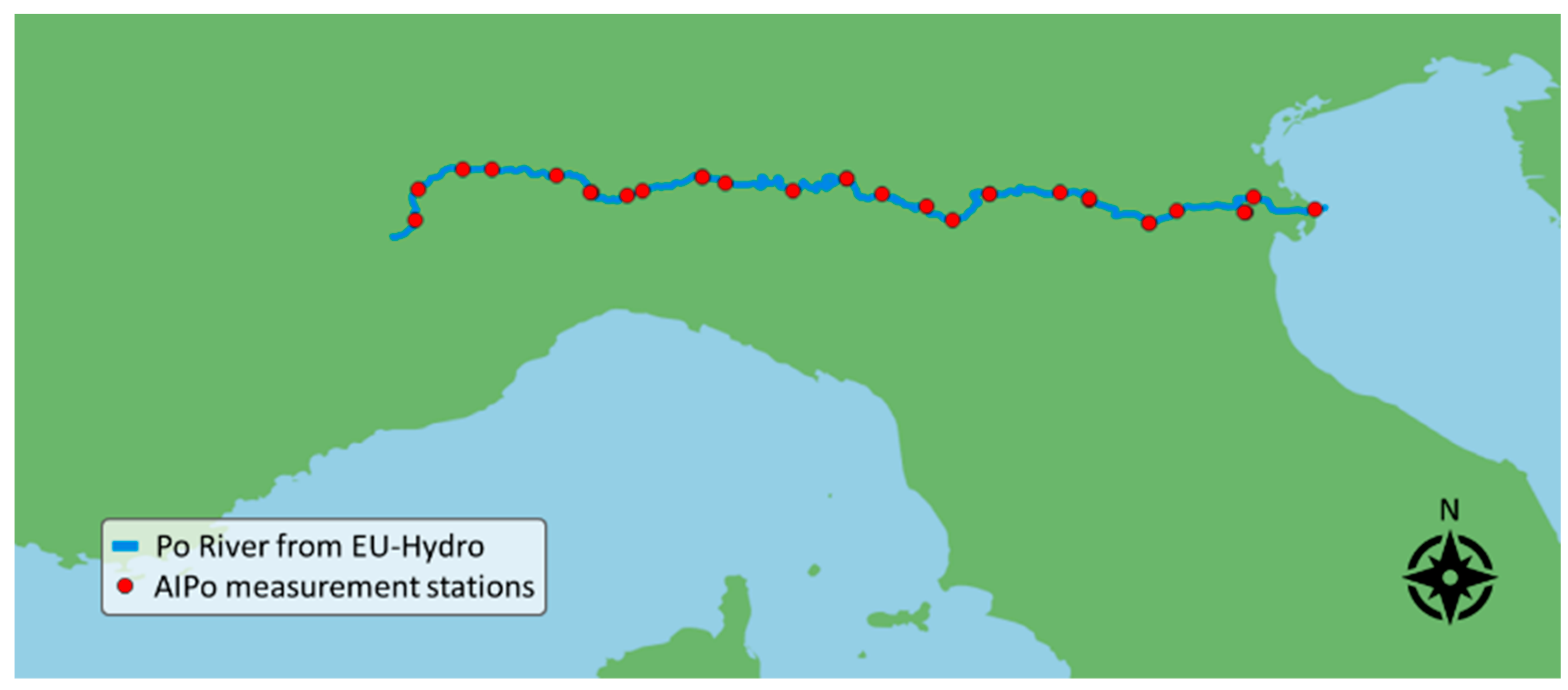
2.1.3. AIPo Water Level Measurements
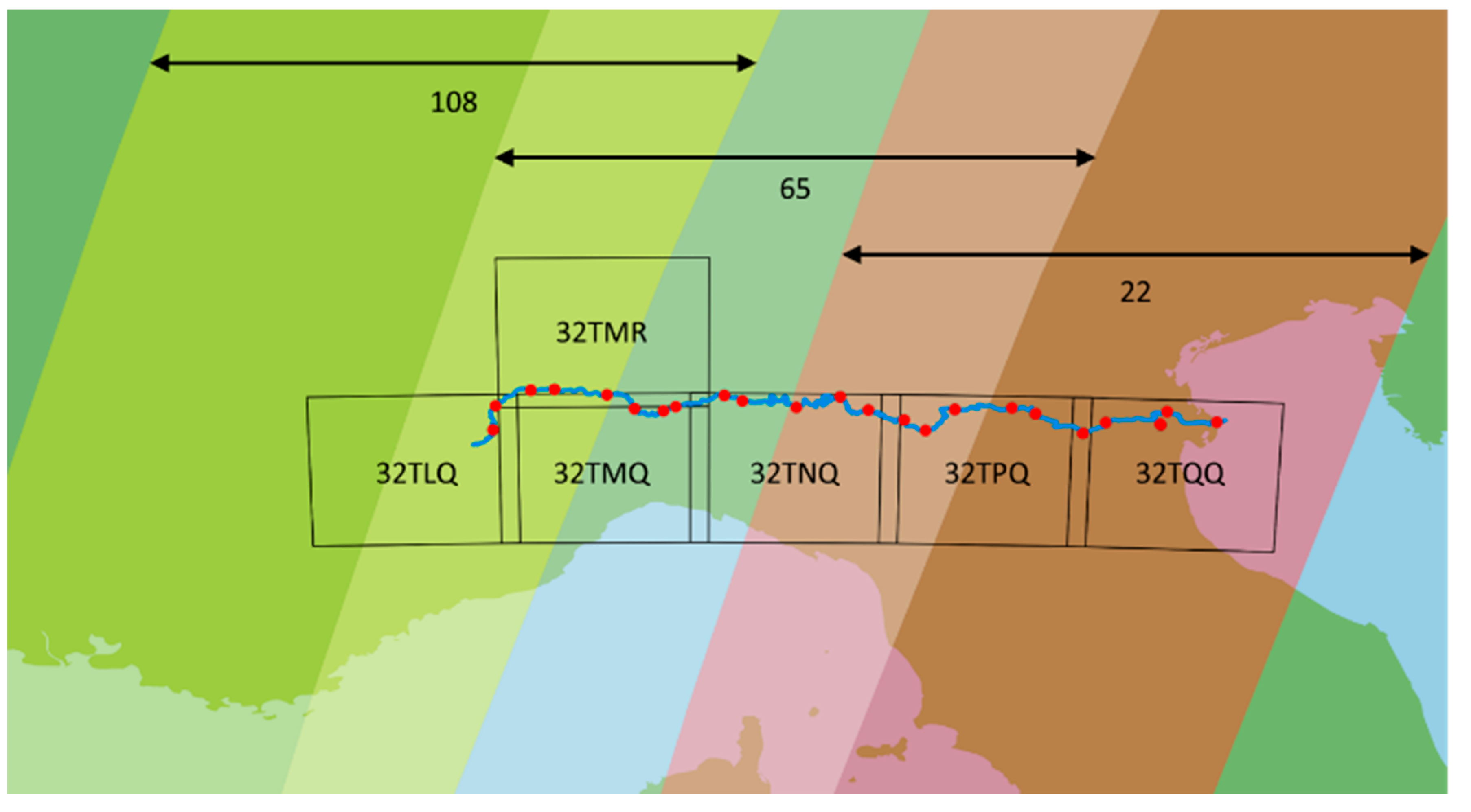
2.1.4. Sentinel-2 Imagery
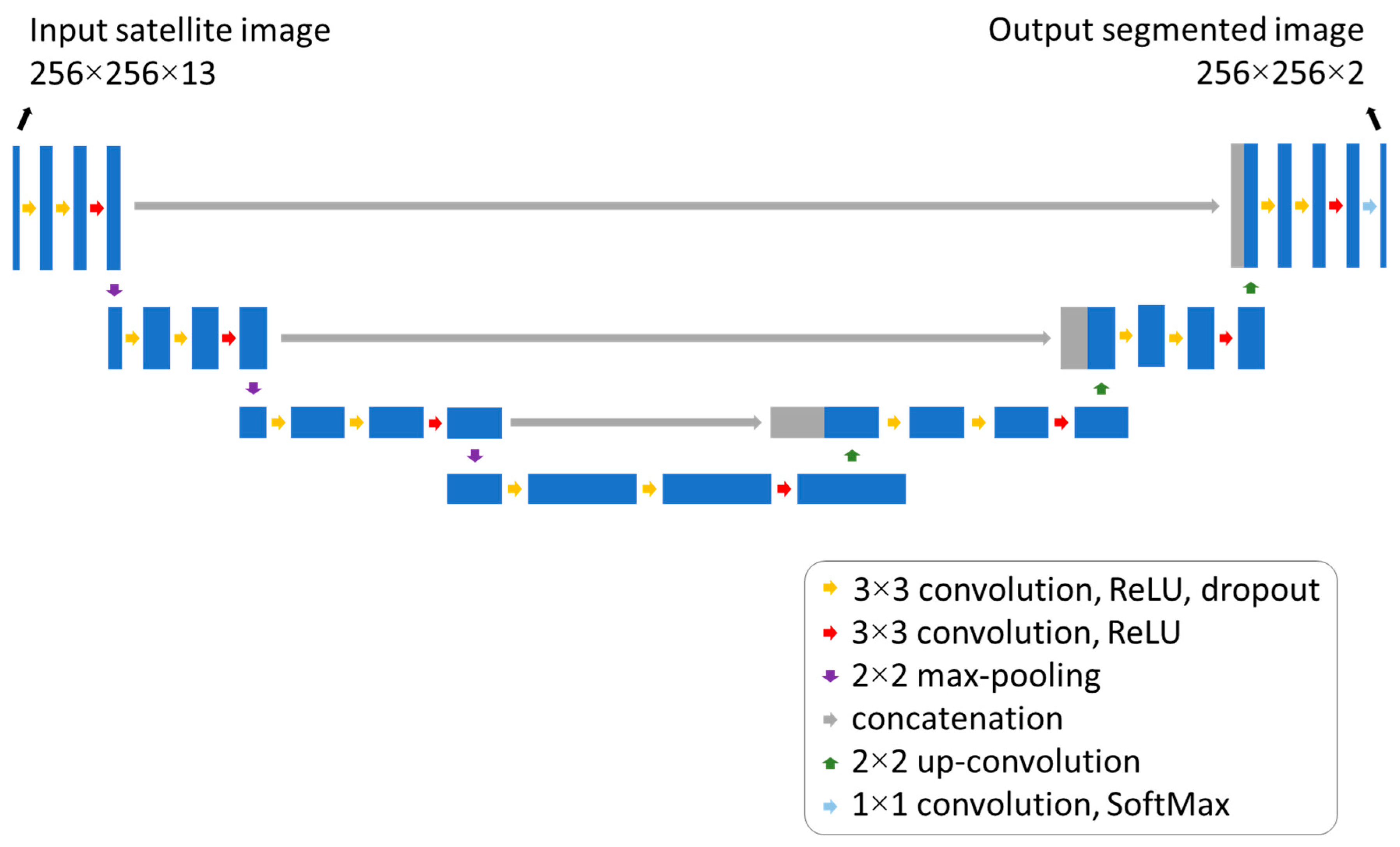
2.2. Neural Network for Water/Land Segmentation of Satellite Images
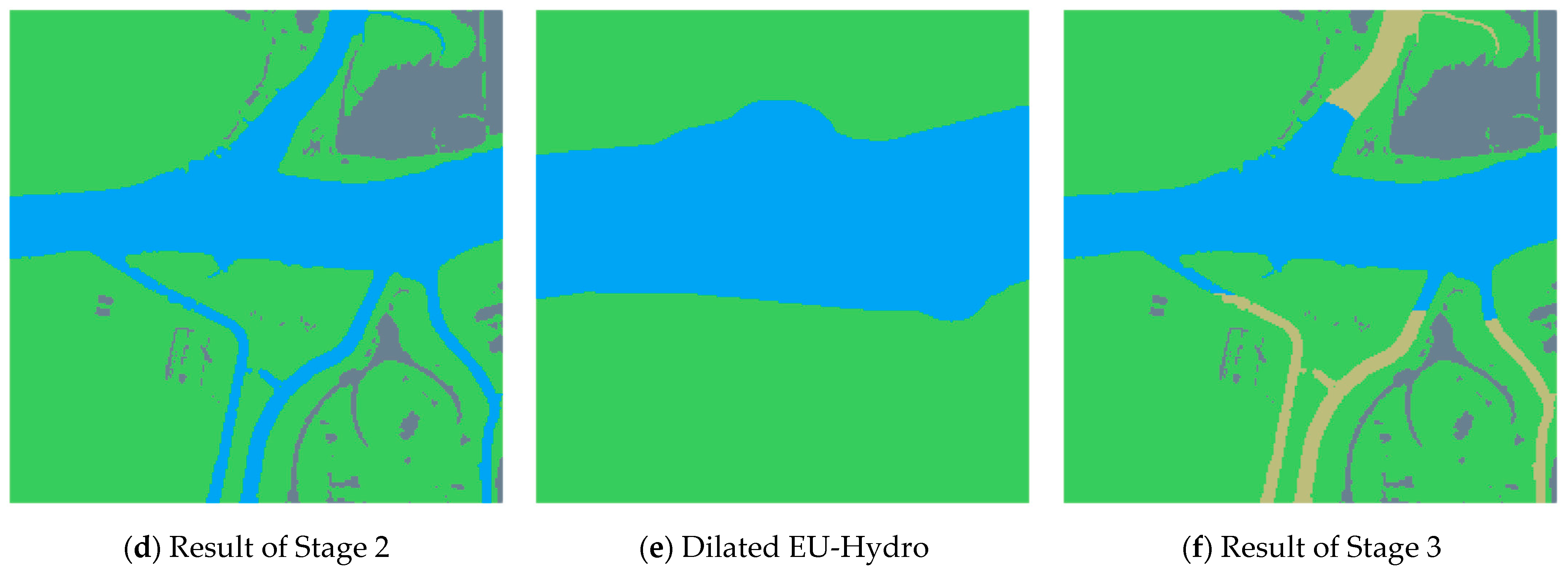
2.3. Sensing Algorithm
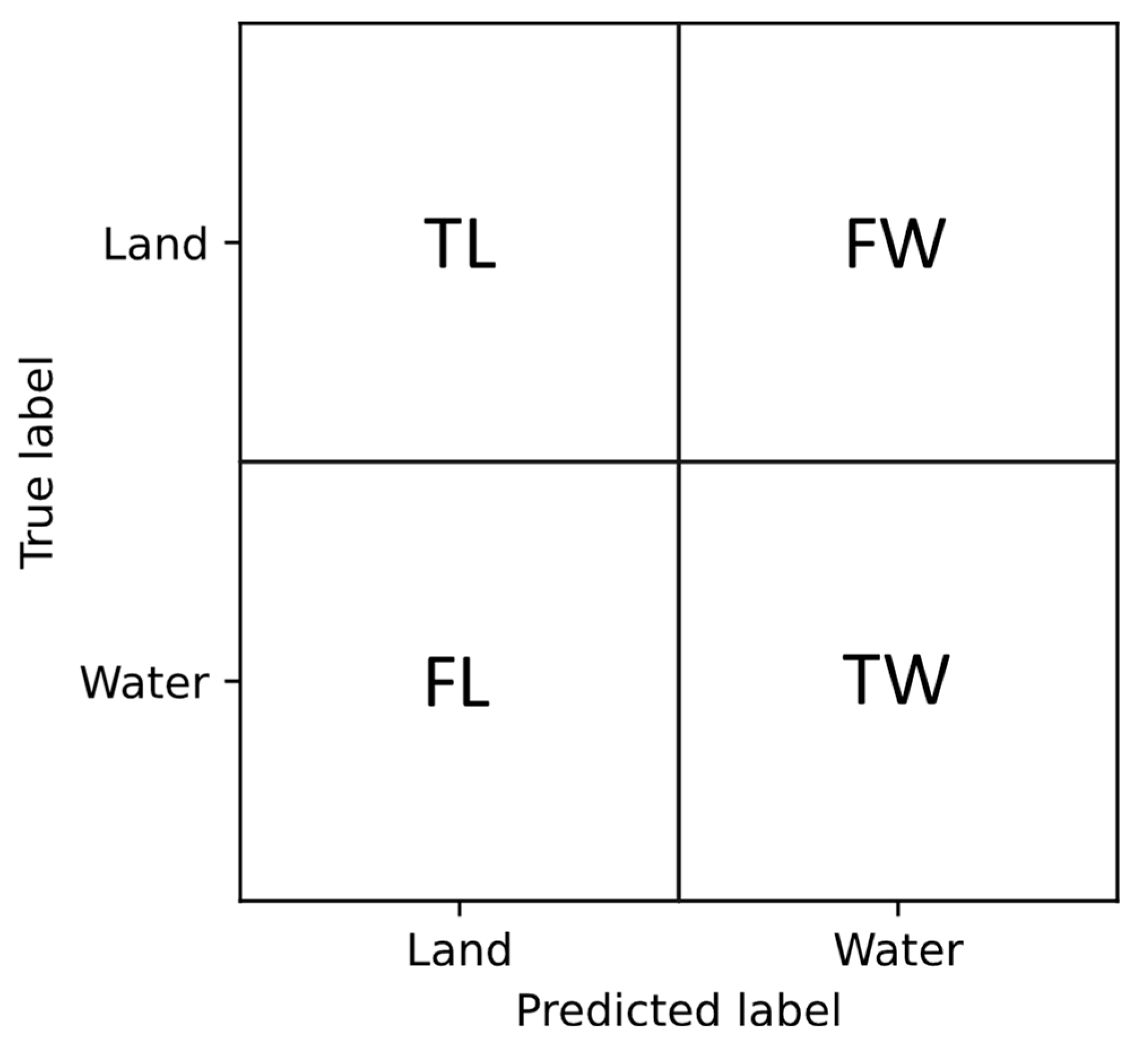
2.4. Methodology for Assessing the Performance of the DNN
- Accuracy, which measures the proportion of correctly classified pixels out of the total number of pixels:
- Precision, also known as Positive Predictive Value (PPV). For the water class, it measures the proportion of pixels predicted as water that are correctly classified:
- Recall, also known as True Positive Rate (TPR). For the water class, it measures the proportion of actual water pixels that are correctly identified.
- F1 score which is the harmonic mean of precision and recall, providing a balanced measure that considers both false positives and false negatives:
2.5. Comparison between Remote Water Area Measurements and Local Water Depth Measurements
2.6. Virtual Gauge Stations along the Po River
3. Results and Discussion
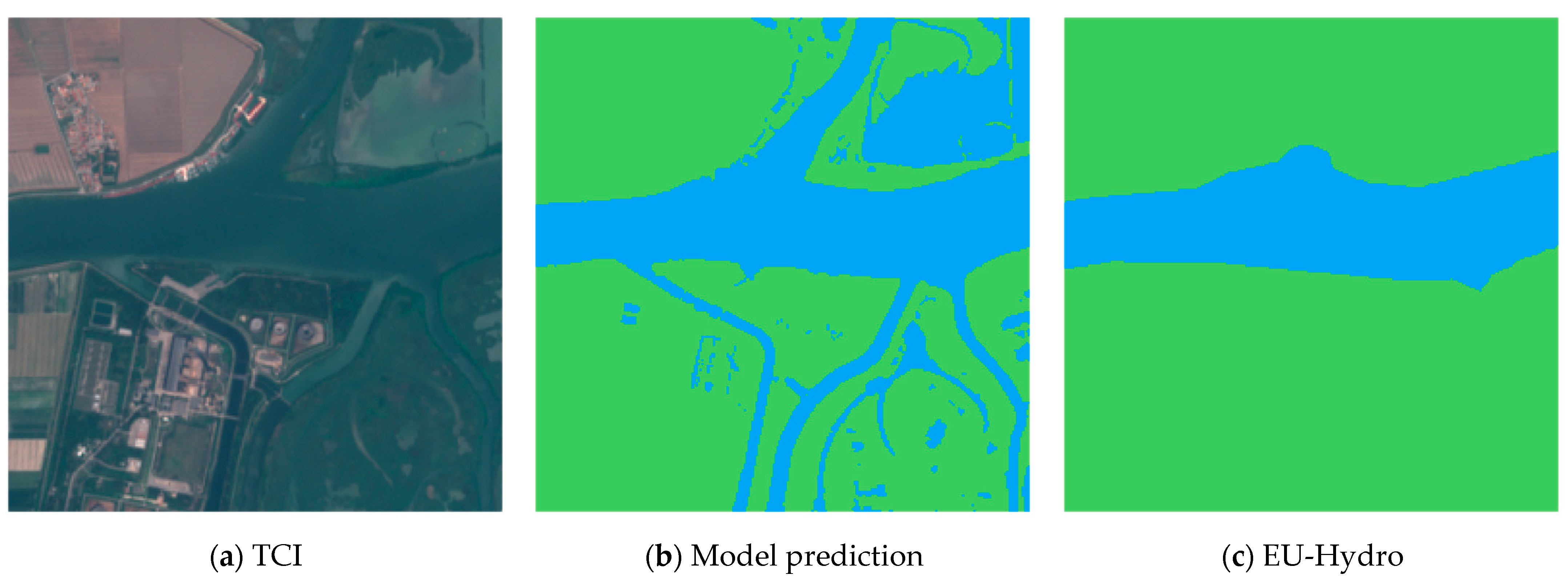
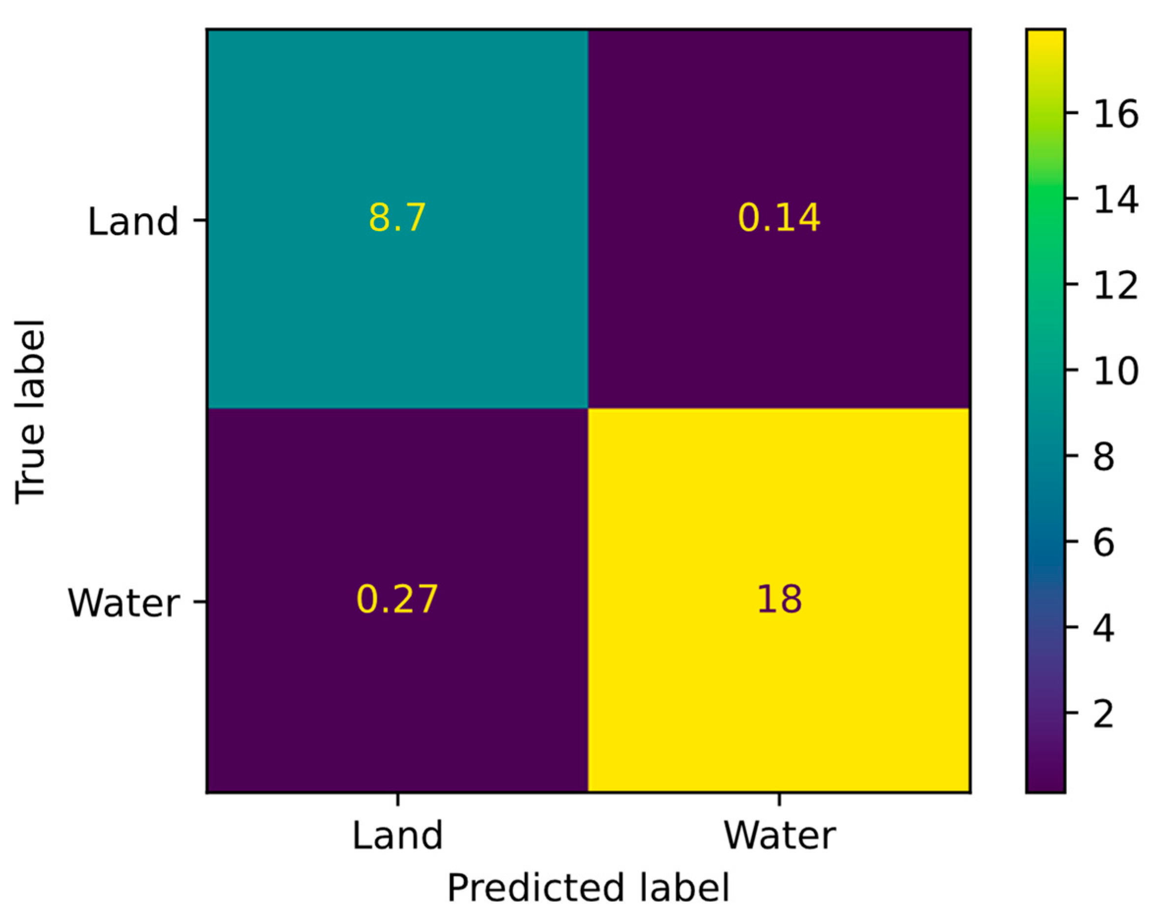
3.1. Assessment of Remote Sensing System Using the SNOWED Validation Set
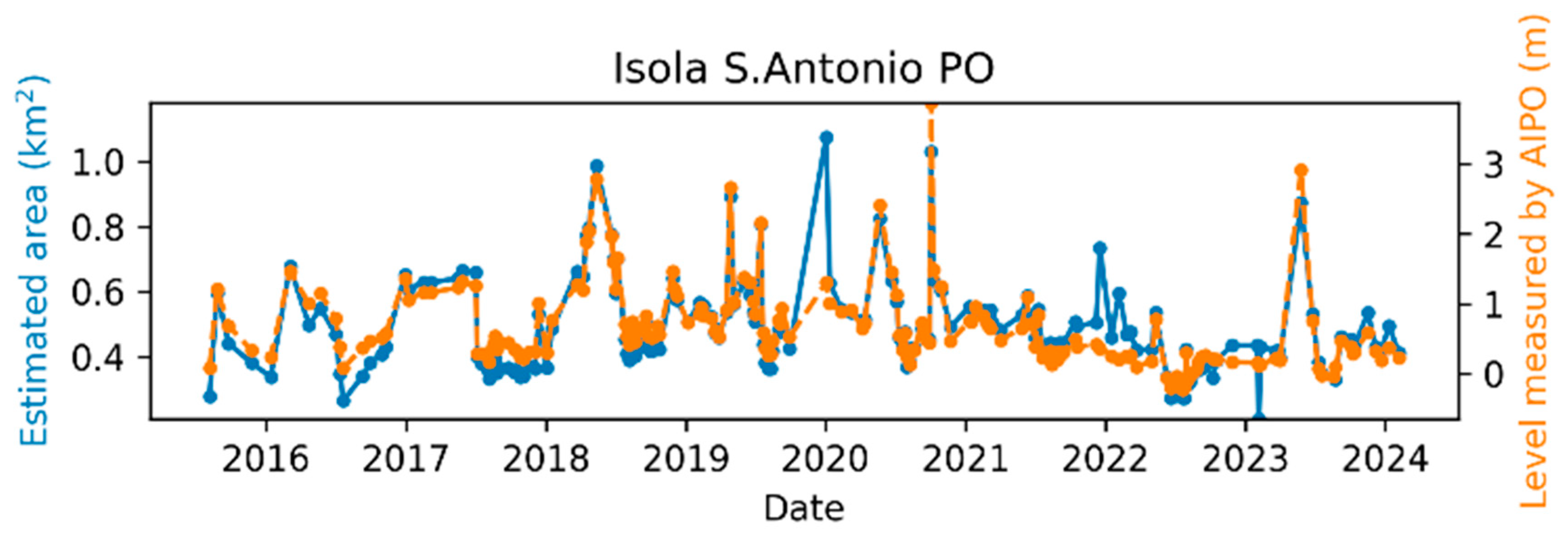
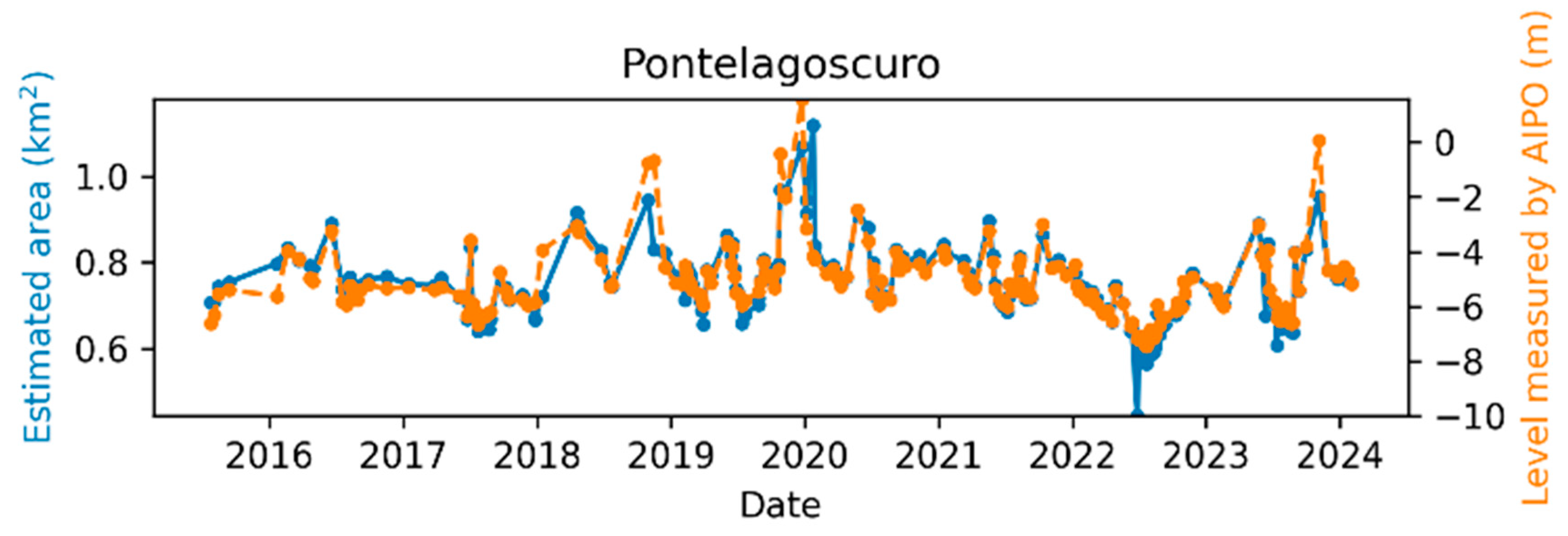
3.2. Assessment of the Final Measurements by Comparison with Measurements by Local Depth Sensors
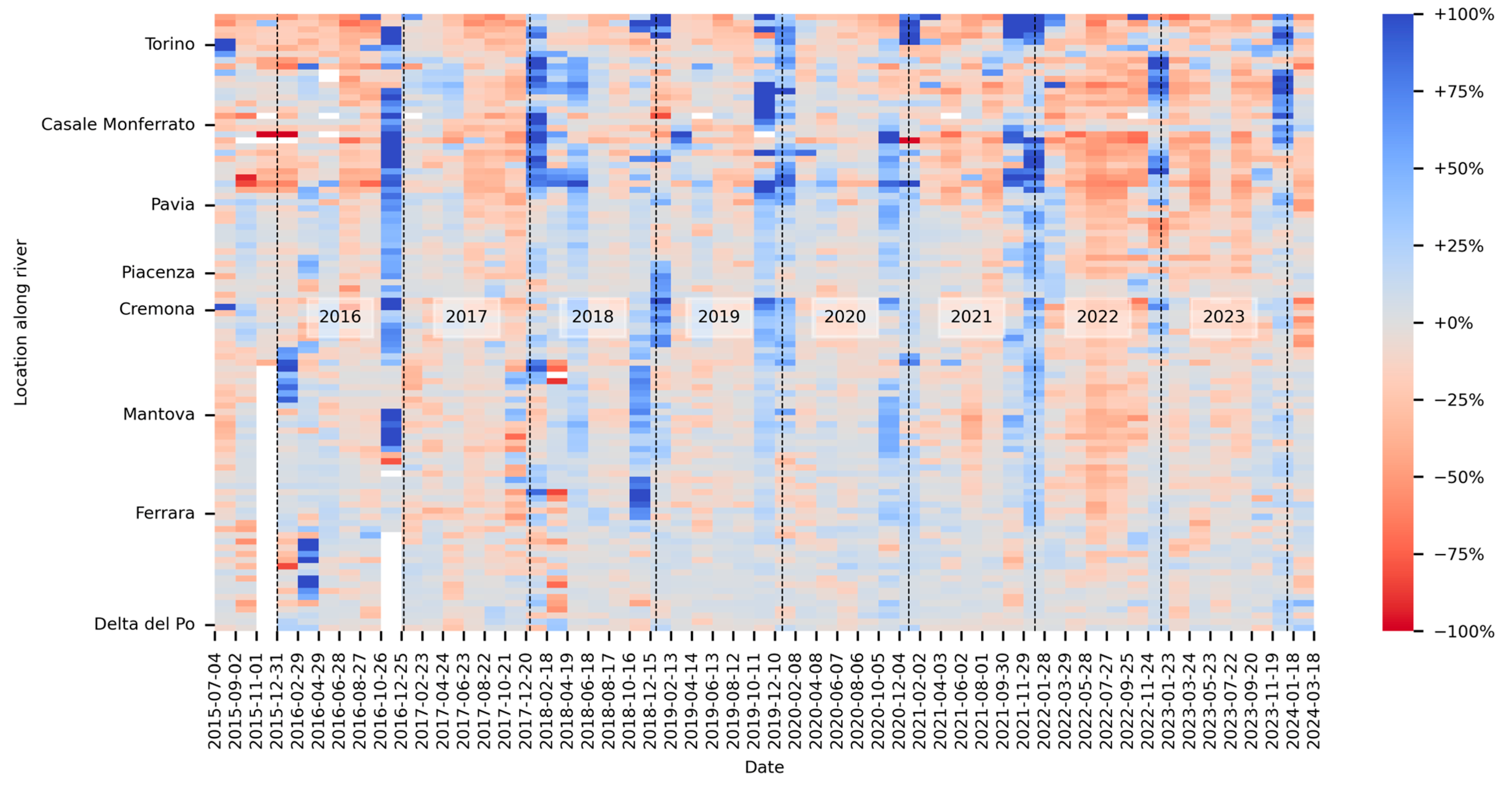
3.3. Space-Time Po River Monitoring
4. Conclusions
Author Contributions
Funding
Institutional Review Board Statement
Informed Consent Statement
Data Availability Statement
Conflicts of Interest
References
- Li, J.; Ma, R.; Cao, Z.; Xue, K.; Xiong, J.; Hu, M.; Feng, X. Satellite Detection of Surface Water Extent: A Review of Methodology. Water 2022, 14, 1148. [Google Scholar] [CrossRef]
- Khandelwal, A.; Karpatne, A.; Marlier, M.E.; Kim, J.; Lettenmaier, D.P.; Kumar, V. An Approach for Global Monitoring of Surface Water Extent Variations in Reservoirs Using MODIS Data. Remote Sens. Environ. 2017, 202, 113–128. [Google Scholar] [CrossRef]
- Yang, X.; Qin, Q.; Yésou, H.; Ledauphin, T.; Koehl, M.; Grussenmeyer, P.; Zhu, Z. Monthly Estimation of the Surface Water Extent in France at a 10-m Resolution Using Sentinel-2 Data. Remote Sens. Environ. 2020, 244, 111803. [Google Scholar] [CrossRef]
- Segovia-Cardozo, D.A.; Rodríguez-Sinobas, L.; Canales-Ide, F.; Zubelzu, S. Design and Field Implementation of a Low-Cost, Open-Hardware Platform for Hydrological Monitoring. Water 2021, 13, 3099. [Google Scholar] [CrossRef]
- Kuang, K.S.C.; Quek, S.T.; Maalej, M. Remote Flood Monitoring System Based on Plastic Optical Fibres and Wireless Motes. Sens. Actuators A Phys. 2008, 147, 449–455. [Google Scholar] [CrossRef]
- Huang, C.; Chen, Y.; Zhang, S.; Wu, J. Detecting, Extracting, and Monitoring Surface Water From Space Using Optical Sensors: A Review. Rev. Geophys. 2018, 56, 333–360. [Google Scholar] [CrossRef]
- McFeeters, S.K. The Use of the Normalized Difference Water Index (NDWI) in the Delineation of Open Water Features. Int. J. Remote Sens. 1996, 17, 1425–1432. [Google Scholar] [CrossRef]
- Xu, H. Modification of Normalised Difference Water Index (NDWI) to Enhance Open Water Features in Remotely Sensed Imagery. Int. J. Remote Sens. 2006, 27, 3025–3033. [Google Scholar] [CrossRef]
- Acharya, T.D.; Subedi, A.; Lee, D.H. Evaluation of Machine Learning Algorithms for Surface Water Extraction in a Landsat 8 Scene of Nepal. Sensors 2019, 19, 2769. [Google Scholar] [CrossRef]
- Hibjur Rahaman, M.; Roshani; Masroor, M.; Sajjad, H. Integrating Remote Sensing Derived Indices and Machine Learning Algorithms for Precise Extraction of Small Surface Water Bodies in the Lower Thoubal River Watershed, India. J. Clean. Prod. 2023, 422, 138563. [Google Scholar] [CrossRef]
- Homepage|Copernicus. Available online: https://www.copernicus.eu/en (accessed on 18 June 2024).
- Landsat Science. Available online: https://landsat.gsfc.nasa.gov/ (accessed on 18 June 2024).
- Tambe, R.G.; Talbar, S.N.; Chavan, S.S. Deep Multi-Feature Learning Architecture for Water Body Segmentation from Satellite Images. J. Vis. Commun. Image Represent. 2021, 77, 103141. [Google Scholar] [CrossRef]
- Boston, T.; Van Dijk, A.; Larraondo, P.R.; Thackway, R. Comparing CNNs and Random Forests for Landsat Image Segmentation Trained on a Large Proxy Land Cover Dataset. Remote Sens. 2022, 14, 3396. [Google Scholar] [CrossRef]
- Yuan, K.; Zhuang, X.; Schaefer, G.; Feng, J.; Guan, L.; Fang, H. Deep-Learning-Based Multispectral Satellite Image Segmentation for Water Body Detection. IEEE J. Sel. Top. Appl. Earth Obs. Remote Sens. 2021, 14, 7422–7434. [Google Scholar] [CrossRef]
- Wieland, M.; Martinis, S.; Kiefl, R.; Gstaiger, V. Semantic Segmentation of Water Bodies in Very High-Resolution Satellite and Aerial Images. Remote Sens. Environ. 2023, 287, 113452. [Google Scholar] [CrossRef]
- Seale, C.; Redfern, T.; Chatfield, P.; Luo, C.; Dempsey, K. Coastline Detection in Satellite Imagery: A Deep Learning Approach on New Benchmark Data. Remote Sens. Environ. 2022, 278, 113044. [Google Scholar] [CrossRef]
- Andria, G.; Scarpetta, M.; Spadavecchia, M.; Affuso, P.; Giaquinto, N. SNOWED: Automatically Constructed Dataset of Satellite Imagery for Water Edge Measurements. Sensors 2023, 23, 4491. [Google Scholar] [CrossRef]
- Scarpetta, M.; Ragolia, M.A.; Spadavecchia, M.; Affuso, P.; Giaquinto, N. The SNOWED Dataset and Its Application to Po River Monitoring Through Satellite Images. In Proceedings of the 2023 IEEE International Conference on Metrology for eXtended Reality, Artificial Intelligence and Neural Engineering (MetroXRAINE), Milano, Italy, 25–27 October 2023; pp. 1092–1097. [Google Scholar]
- Feng, M.; Sexton, J.O.; Channan, S.; Townshend, J.R. A Global, High-Resolution (30-m) Inland Water Body Dataset for 2000: First Results of a Topographic–Spectral Classification Algorithm. Int. J. Digit. Earth 2016, 9, 113–133. [Google Scholar] [CrossRef]
- Pekel, J.-F.; Cottam, A.; Gorelick, N.; Belward, A.S. High-Resolution Mapping of Global Surface Water and Its Long-Term Changes. Nature 2016, 540, 418–422. [Google Scholar] [CrossRef]
- Isikdogan, F.; Bovik, A.C.; Passalacqua, P. Surface Water Mapping by Deep Learning. IEEE J. Sel. Top. Appl. Earth Obs. Remote Sens. 2017, 10, 4909–4918. [Google Scholar] [CrossRef]
- Isikdogan, L.F.; Bovik, A.; Passalacqua, P. Seeing Through the Clouds with DeepWaterMap. IEEE Geosci. Remote Sens. Lett. 2020, 17, 1662–1666. [Google Scholar] [CrossRef]
- QueryPlanet. Water Segmentation Data Set. Available online: http://queryplanet.sentinel-hub.com/index.html?prefix=/#waterdata (accessed on 28 June 2022).
- Yang, T.; Jiang, S.; Hong, Z.; Zhang, Y.; Han, Y.; Zhou, R.; Wang, J.; Yang, S.; Tong, X.; Kuc, T. Sea-Land Segmentation Using Deep Learning Techniques for Landsat-8 OLI Imagery. Mar. Geod. 2020, 43, 105–133. [Google Scholar] [CrossRef]
- Erdem, F.; Bayram, B.; Bakirman, T.; Bayrak, O.C.; Akpinar, B. An Ensemble Deep Learning Based Shoreline Segmentation Approach (WaterNet) from Landsat 8 OLI Images. Adv. Space Res. 2021, 67, 964–974. [Google Scholar] [CrossRef]
- Nyberg, B.; Henstra, G.; Gawthorpe, R.L.; Ravnås, R.; Ahokas, J. Global Scale Analysis on the Extent of River Channel Belts. Nat. Commun 2023, 14, 2163. [Google Scholar] [CrossRef]
- Carbonneau, P.E.; Bizzi, S. Global Mapping of River Sediment Bars. Earth Surface Processes and Landforms 2024, 49, 15–23. [Google Scholar] [CrossRef]
- EU-Hydro—River Network Database—Copernicus Land Monitoring Service. Available online: https://land.copernicus.eu/imagery-in-situ/eu-hydro/eu-hydro-river-network-database (accessed on 19 September 2023).
- Gallaun, H.; Dohr, K.; Puhm, M.; Stumpf, A.; Hugé, J. EU-Hydro—River Net User Guide 1.3; European Environment Agency: Copenhagen, Denmark, 2021. [Google Scholar]
- Monitoraggio Idrografico|AIPO—Agenzia Interregionale per Il Fiume PO. Available online: https://www.agenziapo.it/content/monitoraggio-idrografico-0 (accessed on 26 January 2024).
- Ecosystem, C.D.S. Copernicus Data Space Ecosystem|Europe’s Eyes on Earth. Available online: https://dataspace.copernicus.eu/ (accessed on 5 June 2024).
- Ronneberger, O.; Fischer, P.; Brox, T. U-Net: Convolutional Networks for Biomedical Image Segmentation. In Proceedings of the Medical Image Computing and Computer-Assisted Intervention—MICCAI 2015; Navab, N., Hornegger, J., Wells, W.M., Frangi, A.F., Eds.; Springer International Publishing: Cham, Switzerland, 2015; pp. 234–241. [Google Scholar]
- Scarpetta, M.; Affuso, P.; De Virgilio, M.; Spadavecchia, M.; Andria, G.; Giaquinto, N. Monitoring of Seagrass Meadows Using Satellite Images and U-Net Convolutional Neural Network. In Proceedings of the 2022 IEEE International Instrumentation and Measurement Technology Conference (I2MTC), Ottawa, ON, Canada, 16–19 May 2022; pp. 1–6. [Google Scholar]
- Kingma, D.P.; Ba, J. Adam: A Method for Stochastic Optimization. arXiv 2014, arXiv:1412.6980. [Google Scholar]
- Jadon, S. A Survey of Loss Functions for Semantic Segmentation. In Proceedings of the 2020 IEEE Conference on Computational Intelligence in Bioinformatics and Computational Biology (CIBCB), Vina del Mar, Chile, 27–29 October 2020; pp. 1–7. [Google Scholar]
- Pedrayes, O.D.; Lema, D.G.; García, D.F.; Usamentiaga, R.; Alonso, Á. Evaluation of Semantic Segmentation Methods for Land Use with Spectral Imaging Using Sentinel-2 and PNOA Imagery. Remote Sens. 2021, 13, 2292. [Google Scholar] [CrossRef]
- Ayala, C.; Aranda, C.; Galar, M. Towards Fine-Grained Road Maps Extraction Using Sentinel-2 Imagery. ISPRS Ann. Photogramm. Remote Sens. Spat. Inf. Sci. 2021, V-3–2021, 9–14. [Google Scholar] [CrossRef]
- D’Alessandro, V.I.; Palma, L.D.; Attivissimo, F.; Nisio, A.D.; Lanzolla, A.M.L. U-Net Convolutional Neural Network for Multisource Heterogeneous Iris Segmentation. In Proceedings of the 2023 IEEE International Symposium on Medical Measurements and Applications (MeMeA), Jeju, Republic of Korea, 14–16 June 2023; pp. 1–5. [Google Scholar]
- Kotaridis, I.; Lazaridou, M. Semantic Segmentation Using a UNET Architecture on Sentinel-2 Data. Int. Arch. Photogramm. Remote Sens. Spat. Inf. Sci. 2022, XLIII-B3-2022, 119–126. [Google Scholar] [CrossRef]
- Joint Committee for Guides in Metrology. Evaluation of Measurement Data—Guide to the Expression of Uncertainty in Measurement (GUM 1995 with Minor Corrections); JCGM 100:2008; BIPM: Sèvres, France, 2008. [Google Scholar]
- Zhou, J.; Ke, L.; Ding, X.; Wang, R.; Zeng, F. Monitoring Spatial–Temporal Variations in River Width in the Aral Sea Basin with Sentinel-2 Imagery. Remote Sens. 2024, 16, 822. [Google Scholar] [CrossRef]
- Kazemi Garajeh, M.; Haji, F.; Tohidfar, M.; Sadeqi, A.; Ahmadi, R.; Kariminejad, N. Spatiotemporal Monitoring of Climate Change Impacts on Water Resources Using an Integrated Approach of Remote Sensing and Google Earth Engine. Sci. Rep. 2024, 14, 5469. [Google Scholar] [CrossRef]
- Dubey, A.K.; Gupta, P.K.; Dutta, S.; Singh, R.P. An Improved Methodology to Estimate River Stage and Discharge Using Jason-2 Satellite Data. J. Hydrol. 2015, 529, 1776–1787. [Google Scholar] [CrossRef]
- Wright, N.; Duncan, J.M.A.; Callow, J.N.; Thompson, S.E.; George, R.J. CloudS2Mask: A Novel Deep Learning Approach for Improved Cloud and Cloud Shadow Masking in Sentinel-2 Imagery. Remote Sens. Environ. 2024, 306, 114122. [Google Scholar] [CrossRef]
- Pang, S.; Sun, L.; Tian, Y.; Ma, Y.; Wei, J. Convolutional Neural Network-Driven Improvements in Global Cloud Detection for Landsat 8 and Transfer Learning on Sentinel-2 Imagery. Remote Sens. 2023, 15, 1706. [Google Scholar] [CrossRef]
- Montanari, A.; Nguyen, H.; Rubinetti, S.; Ceola, S.; Galelli, S.; Rubino, A.; Zanchettin, D. Why the 2022 Po River Drought Is the Worst in the Past Two Centuries. Sci. Adv. 2023, 9, eadg8304. [Google Scholar] [CrossRef]


| Tile Identifier | Relative Orbit Number |
|---|---|
| 32TLQ | 108 |
| 32TMR | 65 |
| 32TMQ | 65 |
| 32TNQ | 65 |
| 32TPQ | 22 |
| 32TQQ | 22 |
| ACC | PPV | TPR | F1 | IoU | |
|---|---|---|---|---|---|
| Land | - | 97.0% | 98.5% | 97.7% | 95.6% |
| Water | - | 99.2% | 98.5% | 98.9% | 97.8% |
| Mean | 98.5% | 98.1% | 98.5% | 98.3% | 96.7% |
Disclaimer/Publisher’s Note: The statements, opinions and data contained in all publications are solely those of the individual author(s) and contributor(s) and not of MDPI and/or the editor(s). MDPI and/or the editor(s) disclaim responsibility for any injury to people or property resulting from any ideas, methods, instructions or products referred to in the content. |
© 2024 by the authors. Licensee MDPI, Basel, Switzerland. This article is an open access article distributed under the terms and conditions of the Creative Commons Attribution (CC BY) license (https://creativecommons.org/licenses/by/4.0/).
Share and Cite
Scarpetta, M.; Spadavecchia, M.; Affuso, P.; D’Alessandro, V.I.; Giaquinto, N. Use of the SNOWED Dataset for Sentinel-2 Remote Sensing of Water Bodies: The Case of the Po River. Sensors 2024, 24, 5827. https://doi.org/10.3390/s24175827
Scarpetta M, Spadavecchia M, Affuso P, D’Alessandro VI, Giaquinto N. Use of the SNOWED Dataset for Sentinel-2 Remote Sensing of Water Bodies: The Case of the Po River. Sensors. 2024; 24(17):5827. https://doi.org/10.3390/s24175827
Chicago/Turabian StyleScarpetta, Marco, Maurizio Spadavecchia, Paolo Affuso, Vito Ivano D’Alessandro, and Nicola Giaquinto. 2024. "Use of the SNOWED Dataset for Sentinel-2 Remote Sensing of Water Bodies: The Case of the Po River" Sensors 24, no. 17: 5827. https://doi.org/10.3390/s24175827
APA StyleScarpetta, M., Spadavecchia, M., Affuso, P., D’Alessandro, V. I., & Giaquinto, N. (2024). Use of the SNOWED Dataset for Sentinel-2 Remote Sensing of Water Bodies: The Case of the Po River. Sensors, 24(17), 5827. https://doi.org/10.3390/s24175827