
Correction of Thin Cirrus Absorption Effects in Landsat 8 Thermal Infrared Sensor Images Using the Operational Land Imager Cirrus Band on the Same Satellite Platform


Abstract
1. Introduction
2. Background and Methods
2.1. Background on Cirrus Contamination Effects in Landsat 8/9 Data Products
2.2. The Landsat 8/9 OLI and TIRS Instruments
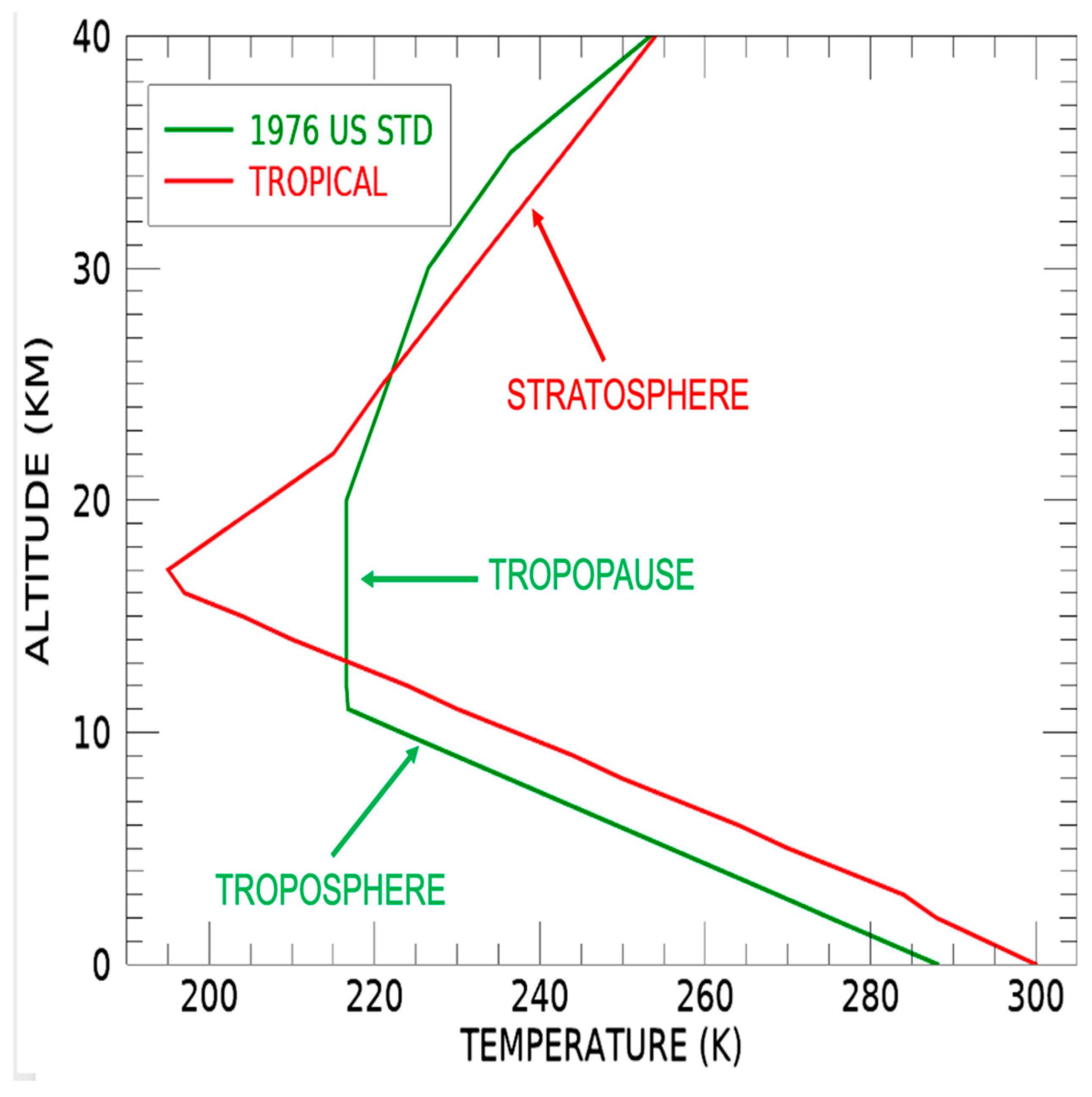
2.3. Cirrus Absorption and Scattering Properties
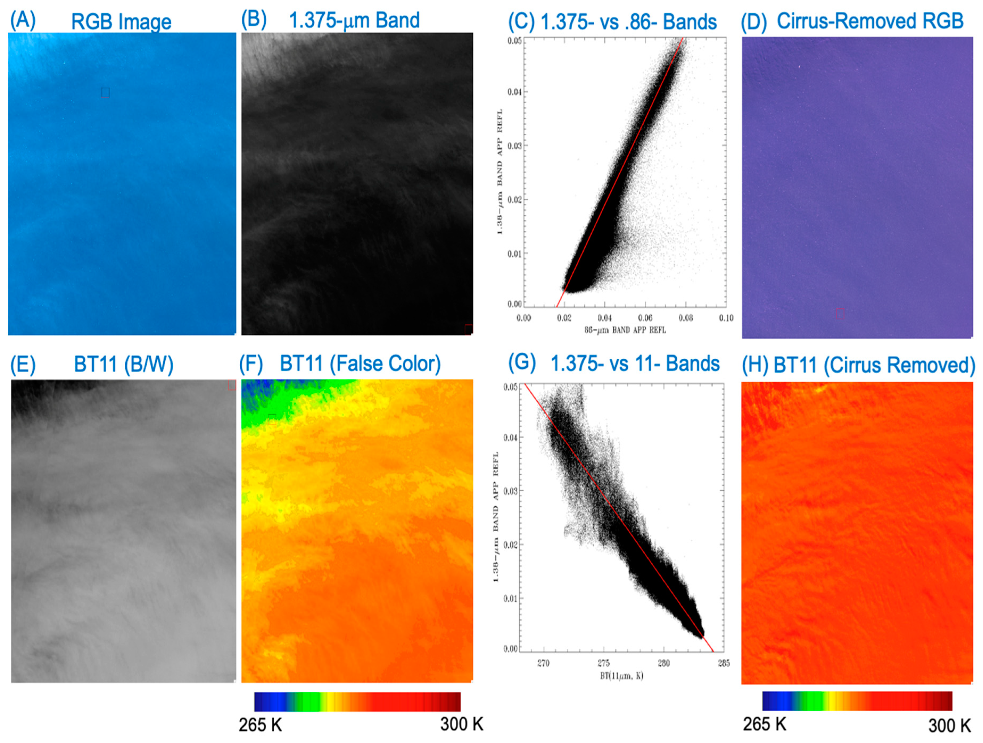
2.4. Removal of Cirrus Effects in Landsat 8 OLI Images for Bands in the 0.4–2.5 μm Range
2.5. The Linear Relationship between 1.375-μm Band Cirrus Scattering and 11-μm Band Ice Absorption
3. Results
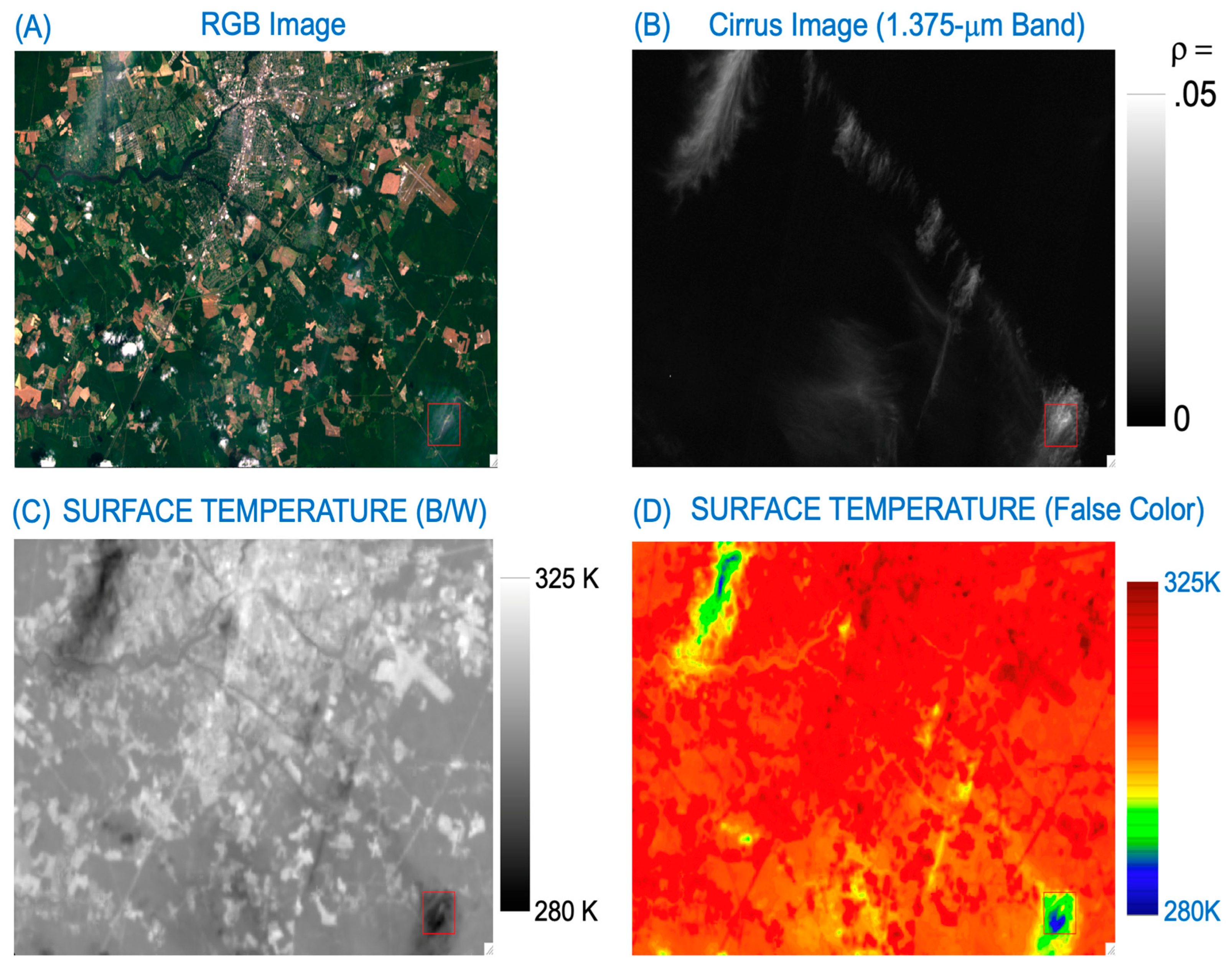
3.1. A Water Scene West of the Coastal Area of Chile, 21 March 2014
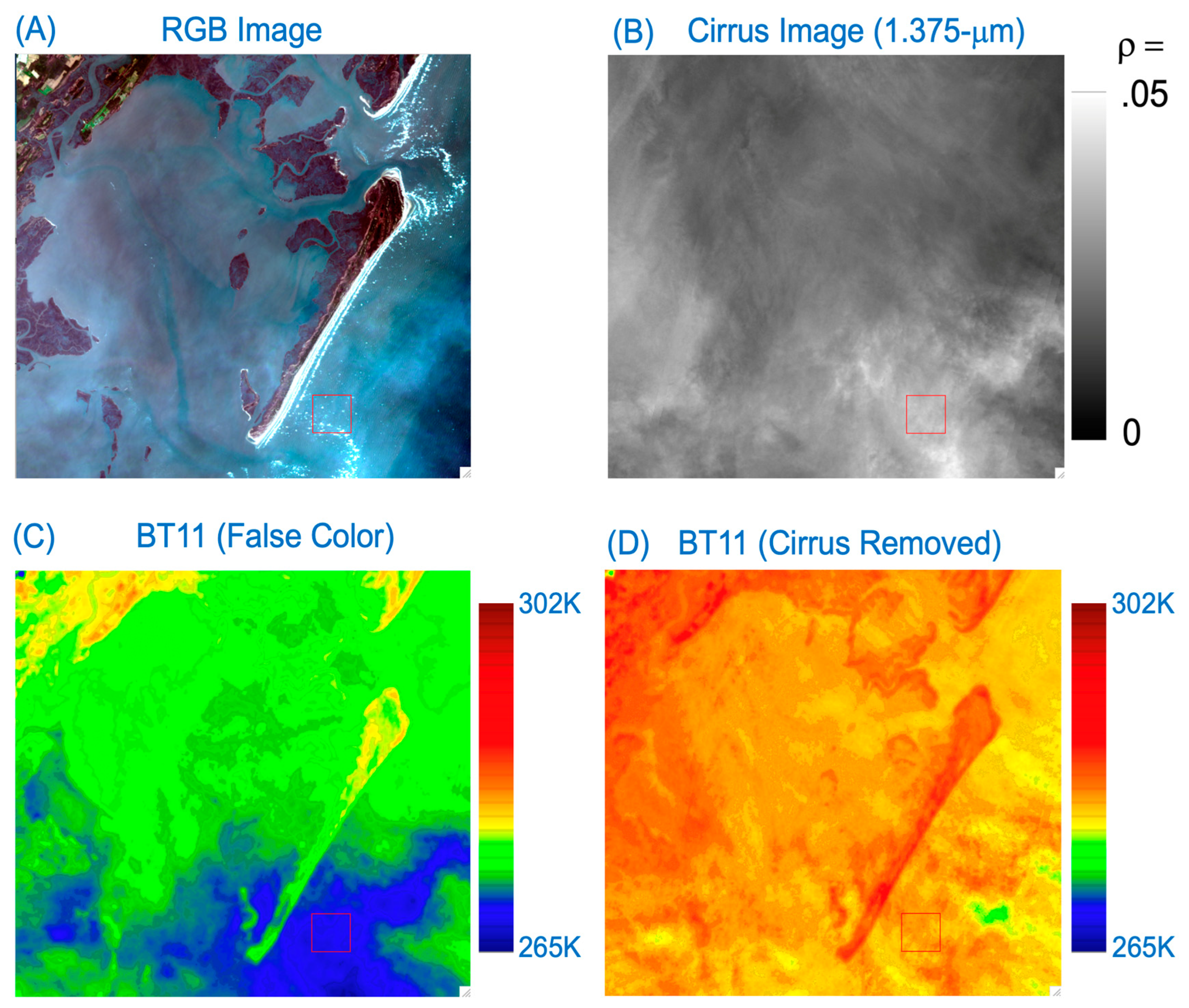
3.2. A Land/Water Boundary Scene, Maryland, USA, 17 April 2014
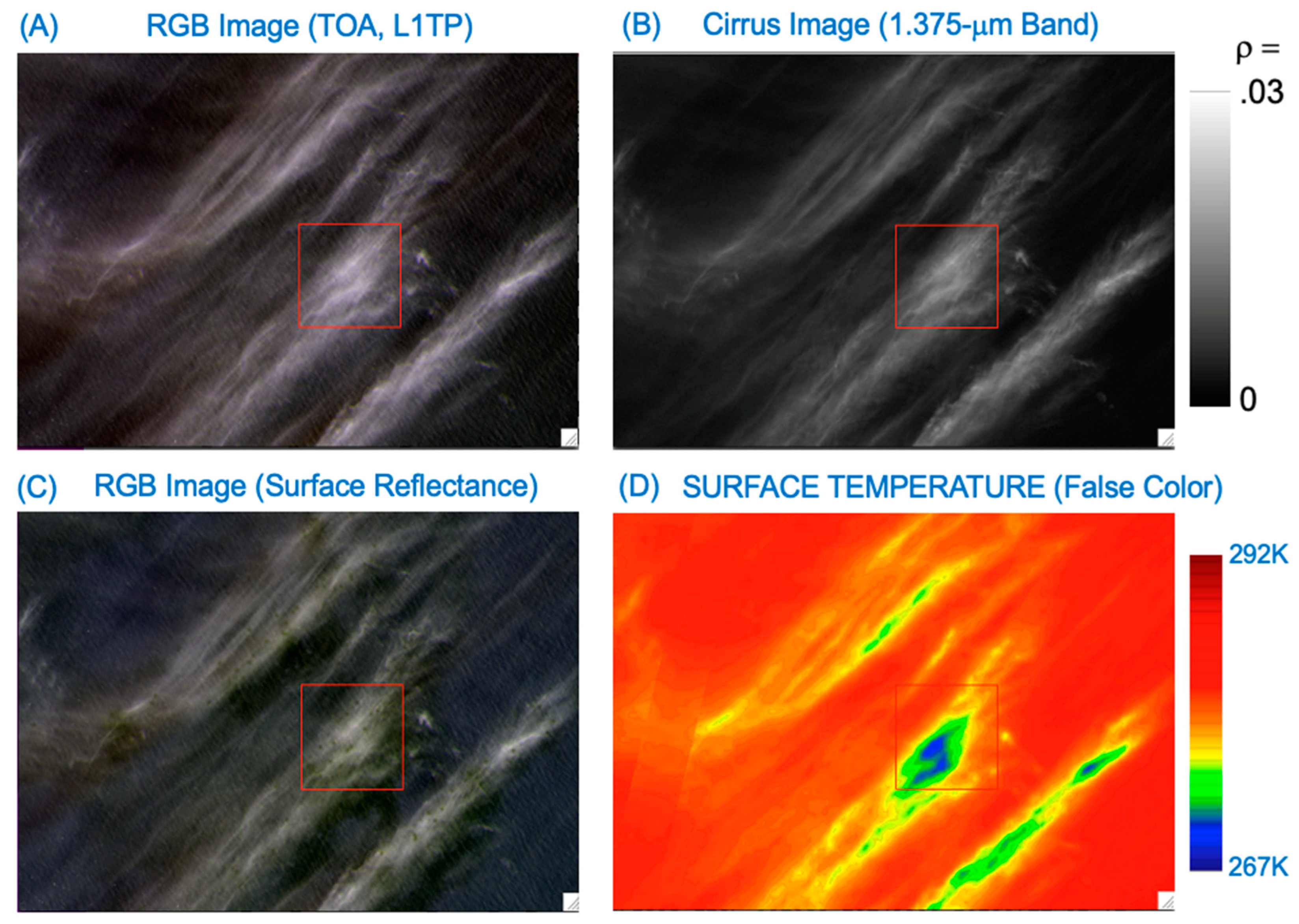
3.3. A Water Scene, Baltic Sea, 11 August 2015
4. Discussion
5. Summary
Author Contributions
Funding
Data Availability Statement
Conflicts of Interest
References
- Landsat 8-9 Calibration and Validation (Cal/Val) Algorithm Description Document (ADD). Available online: https://www.usgs.gov/media/files/landsat-8-9-calibration-validation-algorithm-description-document (accessed on 1 January 2020).
- Landsat 8-9 Collection 2 (C2) Level 2 Science Product (L2SP) Guide. Available online: https://www.usgs.gov/media/files/landsat-8-9-collection-2-level-2-science-product-guide (accessed on 1 January 2020).
- Gao, B.-C.; Kaufman, Y.J. Selection of the 1.375-µm MODIS channel for remote sensing of cirrus clouds and stratospheric aerosols from space. J. Atmos. Sci. 1995, 52, 4231–4237. [Google Scholar] [CrossRef]
- Anderson, M.C.; Norman, J.M.; Kustas, W.P.; Houborg, R.; Starks, P.J.; Agam, N. A thermal-based remote sensing technique for routine mapping of land-surface carbon, water and energy fluxes from field to regional scales. Remote Sens. Environ. 2008, 112, 4227–4241. [Google Scholar] [CrossRef]
- Malakar, N.K.; Hulley, G.C.; Hook, S.J.; Laraby, K.; Cook, M.; Schott, J.R. An Operational Land Surface Temperature Product for Landsat Thermal Data: Methodology and Validation. IEEE Trans. Geosci. Remote Sens. 2018, 56, 5717–5735. [Google Scholar] [CrossRef]
- Hulley, G.C.; Hook, S.J.; Abbott, E.; Malakar, N.; Islam, T.; Abrams, M. The ASTER Global Emissivity Dataset (ASTER GED): Mapping Earth’s emissivity at 100 meter spatial scale. Geophys. Res. Lett. 2015, 42, 7966–7976. [Google Scholar] [CrossRef]
- Salomonson, V.V.; Barnes, W.L.; Maymon, P.W.; Montgomery, H.E.; Ostrow, H. MODIS: Advanced facility instrument for studies of the earth as a system. IEEE Trans. Geosci. Remote Sens. 1989, 27, 145–153. [Google Scholar] [CrossRef]
- King, M.D.; Menzel, W.P.; Kaufman, Y.J.; Tanre, D.; Gao, B.-C.; Platnick, S.; Ackerman, S.A.; Remer, L.A.; Pincus, R.; Hubanks, P.A.; et al. Cloud and aerosol properties, precipitable water, and profiles of temperature and humidity from MODIS. IEEE Trans. Geosci. Remote Sens. 2003, 41, 442–458. [Google Scholar] [CrossRef]
- Laraby, K.G.; Schott, J.R. Uncertainty estimation method and Landsat 7 global validation for the Landsat surface temperature product. Remote Sens. Environ. 2018, 216, 472–481. [Google Scholar] [CrossRef]
- Schaeffer, B.A.; Iiames, J.; Dwyer, J.; Urquhart, E.; Salls, W.; Rover, J.; Seegers, B. An initial validation of Landsat 5 and 7 derived surface water temperature for U.S. lakes, reservoirs, and estuaries. Int. J. Remote Sens. 2018, 39, 7789–7805. [Google Scholar] [CrossRef]
- Shi, J.; Hu, C. Evaluation of ECOSTRESS thermal data over south Florida estuaries. Sensors 2021, 21, 4341. [Google Scholar] [CrossRef]
- Weidberg, N.; Wethey, D.S.; Woodin, S.A. Global intercomparison of hyper-resolution ECOSTRESS coastal sea surface temperature measurements from the Space Station with VIIRS-N20. Remote Sens. 2021, 13, 5021. [Google Scholar] [CrossRef]
- Melton, F.S.; Huntington, J.; Grimm, R.; Herring, J.; Hall, M.; Rollison, D.; Erickson, T.; Allen, R.; Anderson, M.; Fisher, J.B.; et al. OpenET: Filling a Critical Data Gap in Water Management for the Western United States. J. Am. Water Resour. Assoc. 2021, 58, 971–994. [Google Scholar] [CrossRef]
- Gao, B.-C.; Li, R.-R. Removal of thin cirrus scattering effects in Landsat 8 OLI images using the cirrus detecting channel. Remote Sens. 2017, 9, 834. [Google Scholar] [CrossRef]
- Kneizys, F.X.; Shettle, E.P.; Abreu, L.W.; Chetwynd, J.H.; Anderson, G.P.; Gallery, W.O.; Selby, J.E.A.; Clough, S.A. Users Guide to LOWTRAN7, AFGL-TR-88-0177; Environmental Research Papers, No. 1010; Air Force Geophysics Laboratory: Middlesex County, MA, USA, 1988. [Google Scholar]
- U.S. Standard Atmosphere. National Oceanic and Atmospheric Administration, National Aeronautics and Space Administration, United States Air Force, Washington, D.C., October 1976. 1976. Available online: https://www.ngdc.noaa.gov/stp/space-weather/online-publications/miscellaneous/us-standard-atmosphere-1976/us-standard-atmosphere_st76-1562_noaa.pdf (accessed on 1 January 2020).
- Gao, B.-C.; Li, R.-R.; Shettle, E.P. Cloud remote sensing using midwave IR CO2 and N2O slicing channels near 4.5 μm. Remote Sens. 2011, 3, 1006–1013. [Google Scholar] [CrossRef]
- Wei, H.; Yang, P.; Li, J.; Baum, B.A.; Huang, H.L.; Platnick, S.; Hu, Y.; Strow, L. Retrieval of semitransparent ice cloud optical thickness from atmospheric infrared sounder (AIRS) measurements. IEEE Trans. Geosci. Remote Sens. 2004, 47, 2254–2267. [Google Scholar]
- Yang, P.; Hioki, S.; Saito, M.; Kuo, C.-P.; Baum, B.A.; Liou, K.-N. A review of ice cloud optical property models for passive satellite remote sensing. Atmosphere 2018, 9, 499. [Google Scholar] [CrossRef]
- King, M.; Tsay, S.; Platnick, S.; Wang, M.; Liou, K.-N. Cloud Retrieval Algorithms for MODIS: Optical Thickness, Effective Particle Radius, and Thermodynamic Phase, MODIS Algorithm Theoretical Basis Document No. ATBD-MOD-05. 1997. Available online: https://modis.gsfc.nasa.gov/data/atbd/atbd_mod05.pdf (accessed on 1 January 2020).
- Platnick, S.; King, M.; Meyer, K.; Wind, G.; Amarasinghe, N.; Marchant, B.; Arnold, G.T.; Zhang, Z.; Hubanks, P.A.; Ridgway, B.; et al. MODID Cloud Optical Properties: User Guide for Collection 6 Level-2 MOD06/MYD06 Product and Associated level-3 Datasets. 2015. Available online: https://modis-images.gsfc.nasa.gov/_docs/C6MOD06OPUserGuide.pdf (accessed on 1 January 2020).
- Gao, B.-C.; Kaufman, Y.J.; Han, W.; Wiscombe, W.J. Correction of thin cirrus path radiance in the 0.4–1.0 µm spectral region using the sensitive 1.375-µm cirrus detecting channel. J. Geophys. Res. 1998, 103, 32169–32176. [Google Scholar] [CrossRef]
- Gao, B.-C.; Yang, P.; Han, W.; Li, R.-R.; Wiscombe, W.J. An algorithm using visible and 1.38-micron channels to retrieve cirrus cloud reflectances from aircraft and satellite data. IEEE Trans. Geosci. Remote Sens. 2002, 40, 1659–1668. [Google Scholar] [CrossRef]
- Gao, B.-C.; Li, R.-R. The VIIRS cirrus reflectance algorithm. Sensors 2023, 23, 2234. [Google Scholar] [CrossRef] [PubMed]
- Knight, E.J.; Kvaran, G. Landsat-8 operational land imager design, characterization and performance. Remote Sens. 2014, 6, 10286–10305. [Google Scholar] [CrossRef]
- Storey, J.; Choate, M.; Lee, K. Landsat 8 operational land imager on-orbit geometric calibration and performance. Remote Sens. 2014, 6, 11127–11152. [Google Scholar] [CrossRef]
- Nguyen, B.Q.; Tran, T.-N.; Grodzka-Łukaszewska, M.; Sinicyn, G.; Lakshmi, V. Assessment of urbanization-induced land-use change and its impact on temperature, evaporation, and humidity in central Vietnam. Water 2022, 14, 3367. [Google Scholar] [CrossRef]


| Bands | Wavelength (μm) | Resolution (m) |
|---|---|---|
| Band 1–Ultra Blue | 0.43–0.45 | 30 |
| Band 2–Blue | 0.45–0.51 | 30 |
| Band 3–Green | 0.53–0.59 | 30 |
| Band 4–Red | 0.64–0.67 | 30 |
| Band 5–Near-Infrared (NIR) | 0.85–0.88 | 30 |
| Band 6–Shortwave Infrared (SWIR) 1 | 1.57–1.65 | 30 |
| Band 7–Shortwave Infrared (SWIR) 2 | 2.11–2.29 | 30 |
| Band 8–Panchromatic | 0.50–0.68 | 15 |
| Band 9–Cirrus | 1.36–1.39 | 30 |
| Band 10–Thermal Infrared (TIRS) 1 | 10.6–11.19 | 100 |
| Band 11–Thermal Infrared (TIRS) 2 | 11.5–12.51 | 100 |
Disclaimer/Publisher’s Note: The statements, opinions and data contained in all publications are solely those of the individual author(s) and contributor(s) and not of MDPI and/or the editor(s). MDPI and/or the editor(s) disclaim responsibility for any injury to people or property resulting from any ideas, methods, instructions or products referred to in the content. |
© 2024 by the authors. Licensee MDPI, Basel, Switzerland. This article is an open access article distributed under the terms and conditions of the Creative Commons Attribution (CC BY) license (https://creativecommons.org/licenses/by/4.0/).
Share and Cite
Gao, B.-C.; Li, R.-R.; Yang, Y.; Anderson, M. Correction of Thin Cirrus Absorption Effects in Landsat 8 Thermal Infrared Sensor Images Using the Operational Land Imager Cirrus Band on the Same Satellite Platform. Sensors 2024, 24, 4697. https://doi.org/10.3390/s24144697
Gao B-C, Li R-R, Yang Y, Anderson M. Correction of Thin Cirrus Absorption Effects in Landsat 8 Thermal Infrared Sensor Images Using the Operational Land Imager Cirrus Band on the Same Satellite Platform. Sensors. 2024; 24(14):4697. https://doi.org/10.3390/s24144697
Chicago/Turabian StyleGao, Bo-Cai, Rong-Rong Li, Yun Yang, and Martha Anderson. 2024. "Correction of Thin Cirrus Absorption Effects in Landsat 8 Thermal Infrared Sensor Images Using the Operational Land Imager Cirrus Band on the Same Satellite Platform" Sensors 24, no. 14: 4697. https://doi.org/10.3390/s24144697
APA StyleGao, B.-C., Li, R.-R., Yang, Y., & Anderson, M. (2024). Correction of Thin Cirrus Absorption Effects in Landsat 8 Thermal Infrared Sensor Images Using the Operational Land Imager Cirrus Band on the Same Satellite Platform. Sensors, 24(14), 4697. https://doi.org/10.3390/s24144697