Review of Artificial Intelligence Applications for Virtual Sensing of Underground Utilities


Abstract
1. Introduction
2. Aerial Mapping
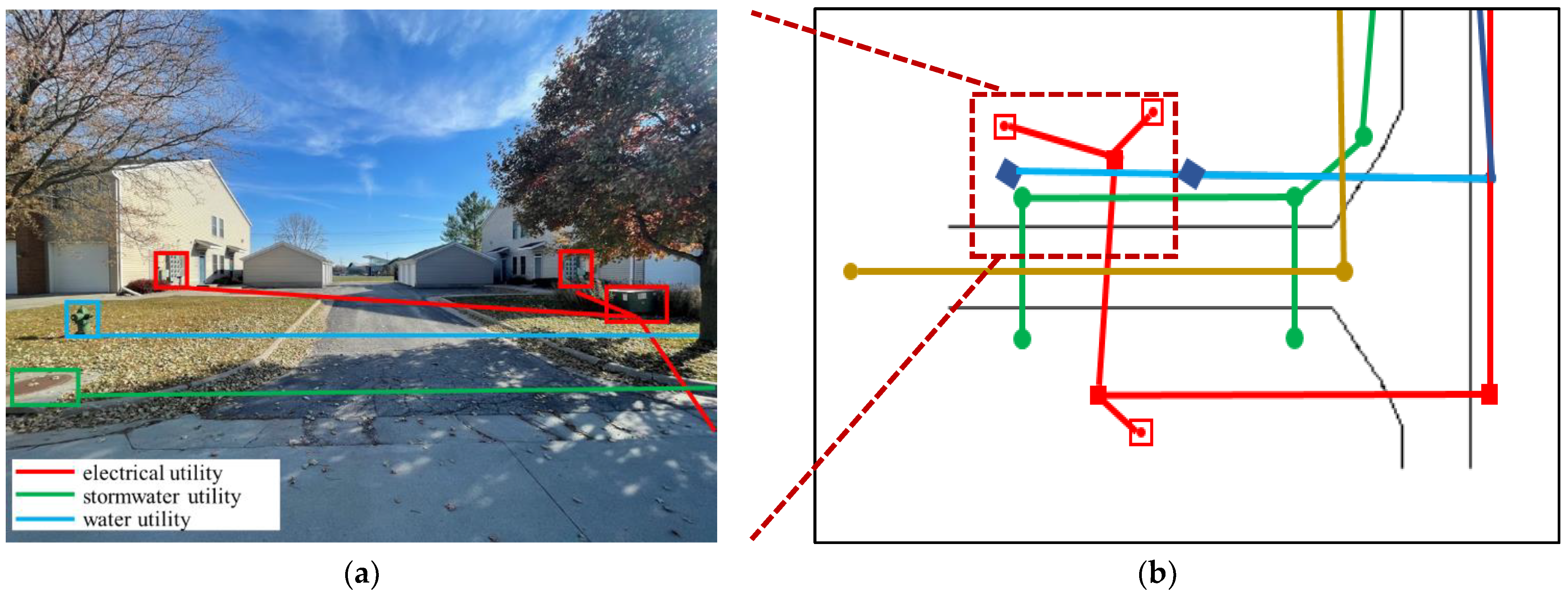
3. Terrestrial Mapping
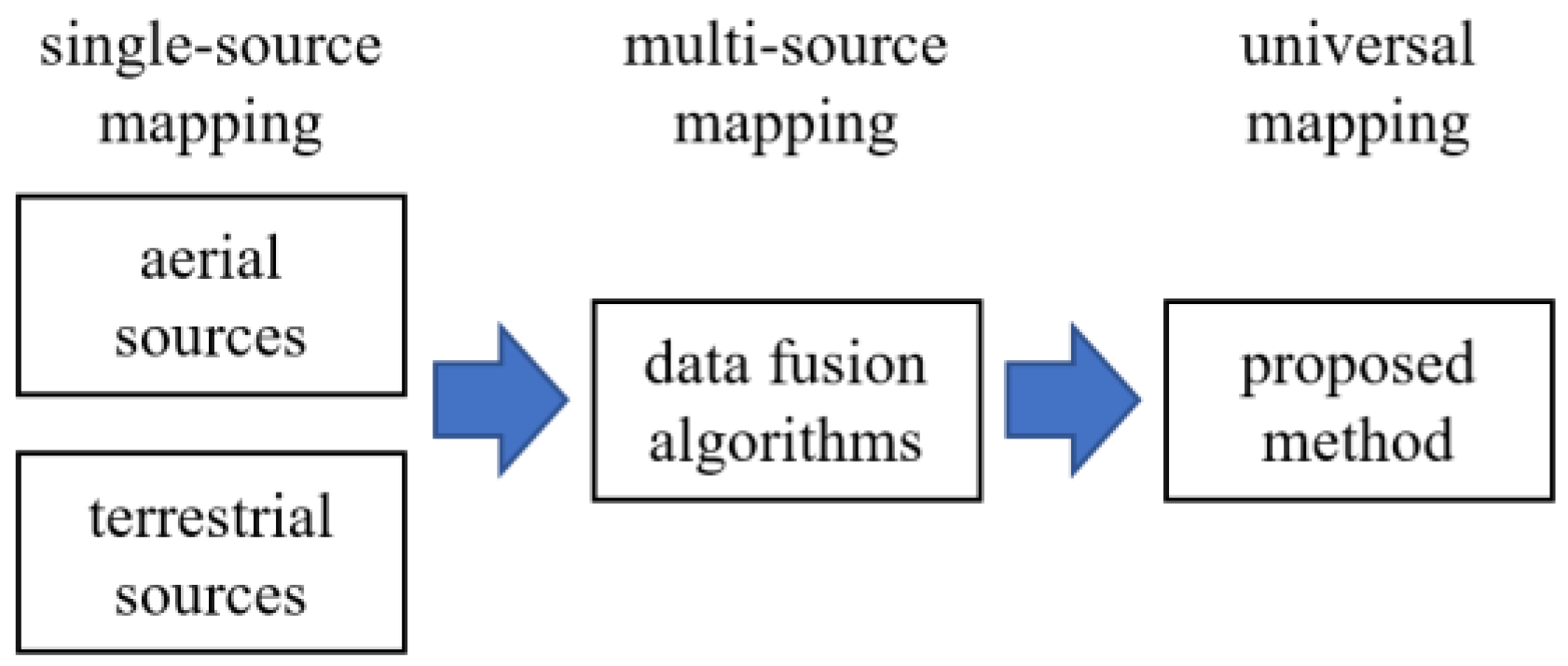
4. Data/Information Fusion
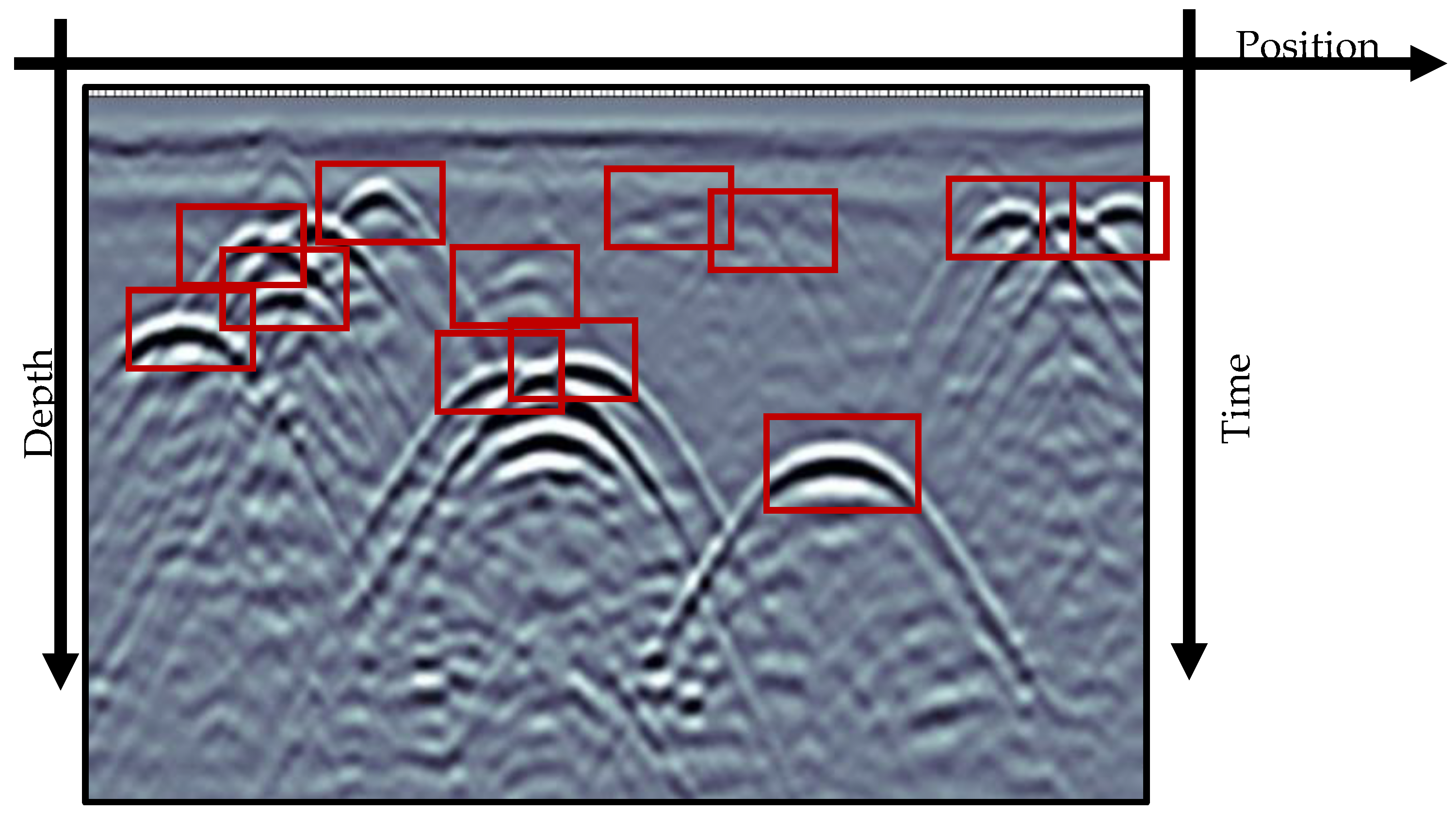
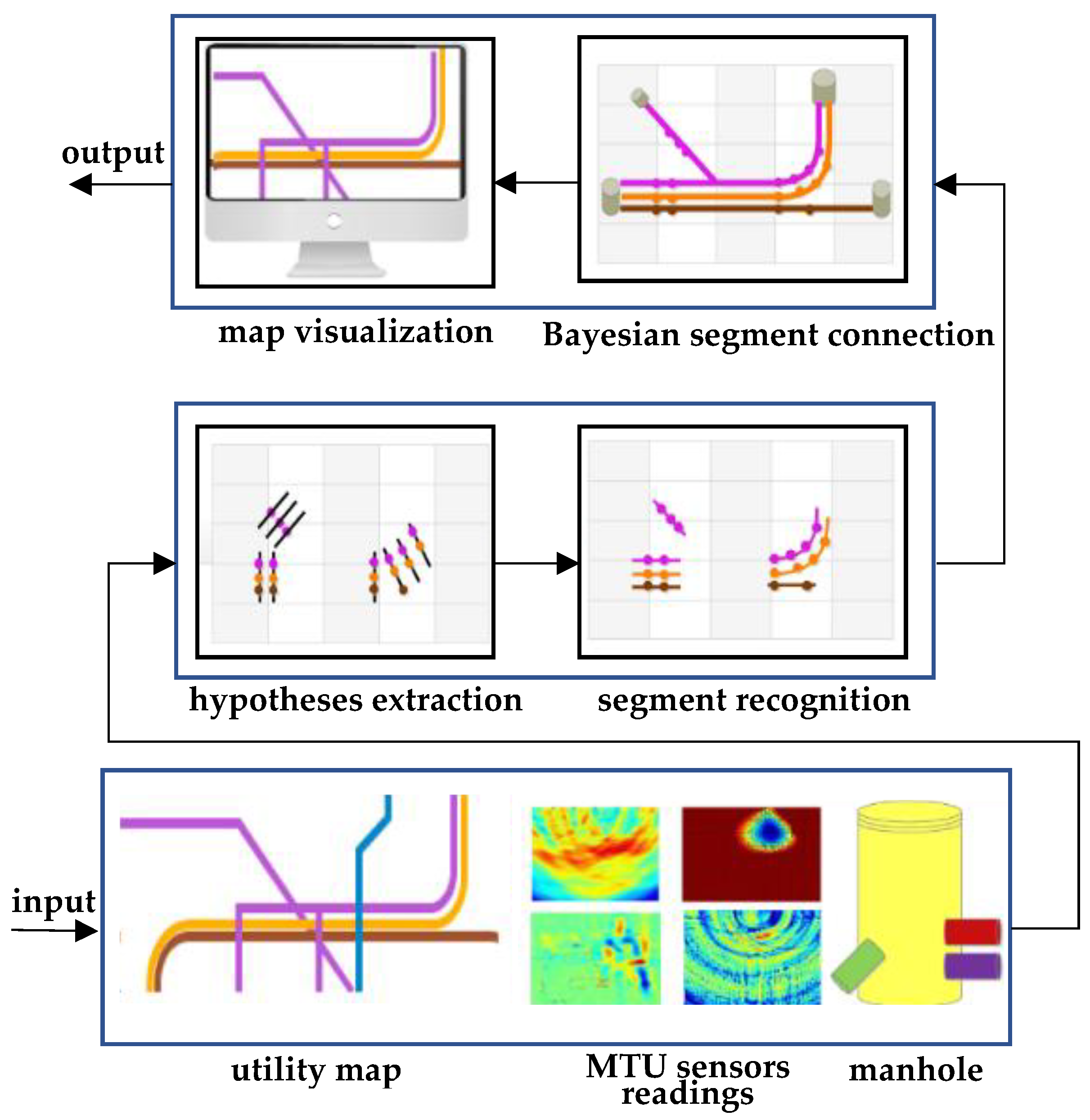
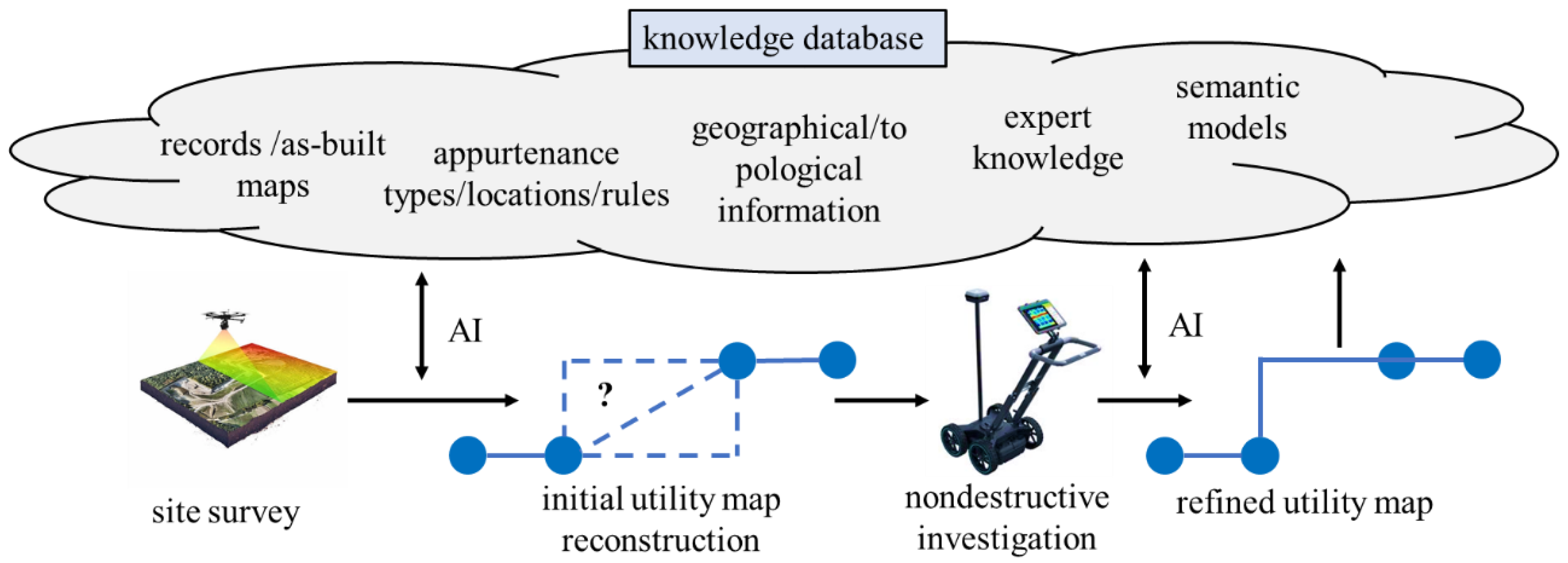
5. Enabling Virtual Sensing of Underground Utilities
6. Conclusions
Funding
Institutional Review Board Statement
Informed Consent Statement
Data Availability Statement
Acknowledgments
Conflicts of Interest
References
- Chen, Q.; Davis, K.; Parker, C. Modeling Damage Prevention Effectiveness Based on Industry Practices and Regulatory Framework; American Society of Mechanical Engineers Digital Collection: New York, NY, USA, 2008; pp. 635–645. [Google Scholar]
- Al-Bayati, A.J.; Panzer, L.; Karakhan, A. Reducing Damages to Underground Infrastructure: Performance Evaluation of One-Call Notification Program. Pract. Period. Struct. Des. Constr. 2019, 24, 04019018. [Google Scholar] [CrossRef]
- Common Ground Alliance (CGA) Damage Information Reporting Tool 2020 Analysis and Recommendations. Available online: https://commongroundalliance.com/Publications-Media/DIRT-Report (accessed on 21 December 2022).
- Dou, Q.; Lin, Z.; Magee, D.R.; Cohn, A.G. 3D Mapping from Partial Observations: An Application to Utility Mapping. Autom. Constr. 2020, 117, 103229. [Google Scholar] [CrossRef]
- Metje, N.; Ahmad, B.; Crossland, S.M. Causes, Impacts and Costs of Strikes on Buried Utility Assets. Proc. Inst. Civ. Eng.-Munic. Eng. 2015, 168, 165–174. [Google Scholar] [CrossRef]
- Costello, S.B.; Chapman, D.N.; Rogers, C.D.F.; Metje, N. Underground Asset Location and Condition Assessment Technologies. Tunn. Undergr. Space Technol. 2007, 22, 524–542. [Google Scholar] [CrossRef]
- Cai, J.; Jeon, J.; Cai, H.; Li, S. Fusing Heterogeneous Information for Underground Utility Map Generation Based on Dempster-Shafer Theory. J. Comput. Civ. Eng. 2020, 34, 04020013. [Google Scholar] [CrossRef]
- ASCE. Standard Guidelines for the Collection and Depiction of Existing Subsurface Utility Data, 38th ed.; American Society of Civil Engineers: Reston, VA, USA, 2002; ISBN 978-0-7844-0645-8. [Google Scholar]
- Jung, Y.J. Utility Impact Rating with Subsurface Utility Engineering in Project Development. Can. J. Civ. Eng. 2009, 36, 1744–1754. [Google Scholar] [CrossRef]
- Huston, D.; Xia, T.; Zhang, Y.; Fan, T.; Orfeo, D.; Razinger, J. Urban Underground Infrastructure Mapping and Assessment. In Proceedings of the Sensors and Smart Structures Technologies for Civil, Mechanical, and Aerospace Systems 2017, Bellingham, WA, USA, 12 April 2017; Volume 10168, pp. 121–131. [Google Scholar]
- Metje, N.; Atkins, P.R.; Brennan, M.J.; Chapman, D.N.; Lim, H.M.; Machell, J.; Muggleton, J.M.; Pennock, S.; Ratcliffe, J.; Redfern, M.; et al. Mapping the Underworld—State-of-the-Art Review. Tunn. Undergr. Space Technol. 2007, 22, 568–586. [Google Scholar] [CrossRef]
- White, C.G.; Nielsen, M.G.; Hayward, R. Lessons Learned Mapping Critical Pressure Pipelines: City of Ottawa Case Studies. Pipelines 2017, 78–88. [Google Scholar] [CrossRef]
- Hassan, H.T.; Akhtar, M.F. Mapping of Power Distribution Network Using Geographical Information System (GIS). Int. J. Emerg. Technol. Adv. Eng. 2012, 2, 343–347. [Google Scholar]
- Li, S.; Cai, H.; Kamat, V.R. Integrating Natural Language Processing and Spatial Reasoning for Utility Compliance Checking. J. Constr. Eng. Manag. 2016, 142, 04016074. [Google Scholar] [CrossRef]
- Anspach, J.H.; Robison, A.G.; Clark, S.T.; Tomanek, M.J. The Need for Utility Data Governance Policies for Improving Lifeline Recovery. Lifelines 2022, 749–755. [Google Scholar] [CrossRef]
- Neupane, B.; Horanont, T.; Aryal, J. Deep Learning-Based Semantic Segmentation of Urban Features in Satellite Images: A Review and Meta-Analysis. Remote Sens. 2021, 13, 808. [Google Scholar] [CrossRef]
- Shermeyer, J.; Van Etten, A. The Effects of Super-Resolution on Object Detection Performance in Satellite Imagery. arXiv 2019, arXiv:1812.04098. [Google Scholar]
- Mnih, V.; Hinton, G.E. Learning to Detect Roads in High-Resolution Aerial Images. In Computer Vision, Proceedings of the ECCV 2010: 11th European Conference on Computer Vision, Heraklion, Crete, Greece, 5–11 September 2010; Daniilidis, K., Maragos, P., Paragios, N., Eds.; Springer: Berlin/Heidelberg, Germany, 2010; pp. 210–223. [Google Scholar]
- Analysing Utility Tunnels and Highway Networks Coordination Dilemma—ScienceDirect. Available online: https://www.sciencedirect.com/science/article/pii/S0886779808000771 (accessed on 21 December 2022).
- Bartoli, O.; Chahinian, N.; Allard, A.; Bailly, J.-S.; Chancibault, K.; Rodriguez, F.; Salles, C.; Tournoud, M.-G.; Delenne, C. Manhole Cover Detection Using a Geometrical Filter on Very High Resolution Aerial and Satellite Images. In Proceedings of the 2015 Joint Urban Remote Sensing Event (JURSE), Lausanne, Switzerland, 30 March–1 April 2015; pp. 1–4. [Google Scholar]
- Pasquet, J.; Desert, T.; Bartoli, O.; Chaumont, M.; Delenne, C.; Subsol, G.; Derras, M.; Chahinian, N. Detection of Manhole Covers in High-Resolution Aerial Images of Urban Areas by Combining Two Methods. IEEE J. Sel. Top. Appl. Earth Obs. Remote Sens. 2016, 9, 1802–1807. [Google Scholar] [CrossRef]
- Timofte, R.; Van Gool, L. Multi-View Manhole Detection, Recognition, and 3D Localisation. In Proceedings of the 2011 IEEE International Conference on Computer Vision Workshops (ICCV Workshops), Online, 6–13 November 2011; pp. 188–195. [Google Scholar]
- Santos, A.; Marcato Junior, J.; de Andrade Silva, J.; Pereira, R.; Matos, D.; Menezes, G.; Higa, L.; Eltner, A.; Ramos, A.P.; Osco, L.; et al. Storm-Drain and Manhole Detection Using the RetinaNet Method. Sensors 2020, 20, 4450. [Google Scholar] [CrossRef] [PubMed]
- Moy de Vitry, M.; Schindler, K.; Rieckermann, J.; Leitão, J.P. Sewer Inlet Localization in UAV Image Clouds: Improving Performance with Multiview Detection. Remote Sens. 2018, 10, 706. [Google Scholar] [CrossRef]
- Al-Kaff, A.; Martín, D.; García, F.; de la Escalera, A.; María Armingol, J. Survey of Computer Vision Algorithms and Applications for Unmanned Aerial Vehicles. Expert Syst. Appl. 2018, 92, 447–463. [Google Scholar] [CrossRef]
- Liu, W.; Cheng, D.; Yin, P.; Yang, M.; Li, E.; Xie, M.; Zhang, L. Small Manhole Cover Detection in Remote Sensing Imagery with Deep Convolutional Neural Networks. ISPRS Int. J. Geo-Inf. 2019, 8, 49. [Google Scholar] [CrossRef]
- Yu, Y.; Guan, H.; Ji, Z. Automated Detection of Urban Road Manhole Covers Using Mobile Laser Scanning Data. IEEE Trans. Intell. Transp. Syst. 2015, 16, 3258–3269. [Google Scholar] [CrossRef]
- Turkan, Y.; Hong, J.; Laflamme, S.; Puri, N. Adaptive Wavelet Neural Network for Terrestrial Laser Scanner-Based Crack Detection. Autom. Constr. 2018, 94, 191–202. [Google Scholar] [CrossRef]
- Wei, Z.; Yang, M.; Wang, L.; Ma, H.; Chen, X.; Zhong, R. Customized Mobile LiDAR System for Manhole Cover Detection and Identification. Sensors 2019, 19, 2422. [Google Scholar] [CrossRef] [PubMed]
- Gouda, M.; Shalkamy, A.; Li, X.; El-Basyouny, K. Fully Automated Algorithm for Light Pole Detection and Mapping in Rural Highway Environment Using Mobile Light Detection and Ranging Point Clouds. Transp. Res. Rec. 2022, 2676, 03611981221082531. [Google Scholar] [CrossRef]
- Osman, H.M.; El-Diraby, T.E. Knowledge-Enabled Decision Support System for Routing Urban Utilities. J. Constr. Eng. Manag. 2011, 137, 198–213. [Google Scholar] [CrossRef]
- Xu, X.; Cai, H. Semantic Approach to Compliance Checking of Underground Utilities. Autom. Constr. 2020, 109, 103006. [Google Scholar] [CrossRef]
- Xu, X.; Cai, H. Ontology and Rule-Based Natural Language Processing Approach for Interpreting Textual Regulations on Underground Utility Infrastructure. Adv. Eng. Inform. 2021, 48, 101288. [Google Scholar] [CrossRef]
- Chahinian, N.; Delenne, C.; Commandré, B.; Derras, M.; Deruelle, L.; Bailly, J.-S. Automatic Mapping of Urban Wastewater Networks Based on Manhole Cover Locations. Comput. Environ. Urban Syst. 2019, 78, 101370. [Google Scholar] [CrossRef]
- Highway/Utility Guide. Available online: https://www.fhwa.dot.gov/utilities/010604.pdf (accessed on 20 December 2022).
- Chen, H.; Cohn, A.G. Buried Utility Pipeline Mapping Based on Multiple Spatial Data Sources: A Bayesian Data Fusion Approach. In Proceedings of the Twenty-Second International Joint Conference on Artificial Intelligence, Barcelona, Catalonia, Spain, 16–22 July 2011. [Google Scholar]
- Lanka, M.; Butler, A.; Sterling, R. Use of Approximate Reasoning Techniques for Locating Underground Utilities. Tunn. Undergr. Space Technol. 2001, 16, 13–31. [Google Scholar] [CrossRef]
- Sciulli, A.E. Surveys of Subsurface Utilities Can Reduce Risk in Plant Decommissioning. Nat. Gas Electr. 2015, 31, 9–14. [Google Scholar] [CrossRef]
- Uslu, B.; Jung, Y.J.; Sinha, S.K. Underground Utility Locating Technologies for Condition Assessment and Renewal Engineering of Water Pipeline Infrastructure Systems. J. Pipeline Syst. Eng. Pract. 2016, 7, 04016011. [Google Scholar] [CrossRef]
- Jeong, H.; Arboleda, C.; Abraham, D. Imaging and Locating Buried Utilities; JTRP Technical Reports; Joint Transportation Research Program, Indiana Department of Transportation and Purdue University: West Lafayette, IN, USA, 2003; pp. 57–96. [Google Scholar]
- Najafi, D.M.; Gokhale, D.S.; Calderón, D.R.; Ma, D.B. Overview and Comparison of Trenchless Technologies; McGraw-Hill Education: New York, NY, USA, 2021; ISBN 978-1-260-45873-2. [Google Scholar]
- Royal, A.C.D.; Atkins, P.R.; Brennan, M.J.; Chapman, D.N.; Chen, H.; Cohn, A.G.; Foo, K.Y.; Goddard, K.F.; Hayes, R.; Hao, T.; et al. Site Assessment of Multiple-Sensor Approaches for Buried Utility Detection. Int. J. Geophys. 2011, 2011, e496123. [Google Scholar] [CrossRef]
- Metwaly, M. Application of GPR Technique for Subsurface Utility Mapping: A Case Study from Urban Area of Holy Mecca, Saudi Arabia. Measurement 2015, 60, 139–145. [Google Scholar] [CrossRef]
- Dou, Q.; Wei, L.; Magee, D.R.; Atkins, P.R.; Chapman, D.N.; Curioni, G.; Goddard, K.F.; Hayati, F.; Jenks, H.; Metje, N.; et al. 3D Buried Utility Location Using A Marching-Cross-Section Algorithm for Multi-Sensor Data Fusion. Sensors 2016, 16, 1827. [Google Scholar] [CrossRef] [PubMed]
- Ambrosanio, M.; Franceschini, S.; Autorino, M.M.; Pascazio, V. Convolutional Neural Networks for Tomographic MIMO Ground Penetrating Radar Imaging. In Proceedings of the 2021 7th Asia-Pacific Conference on Synthetic Aperture Radar (APSAR), Online, 1–3 November 2021; pp. 1–5. [Google Scholar]
- Lei, W.; Hou, F.; Xi, J.; Tan, Q.; Xu, M.; Jiang, X.; Liu, G.; Gu, Q. Automatic Hyperbola Detection and Fitting in GPR B-Scan Image. Autom. Constr. 2019, 106, 102839. [Google Scholar] [CrossRef]
- Manataki, M.; Vafidis, A.; Sarris, A. GPR Data Interpretation Approaches in Archaeological Prospection. Appl. Sci. 2021, 11, 7531. [Google Scholar] [CrossRef]
- Lee, K.L.; Mokji, M.M. Automatic Target Detection in GPR Images Using Histogram of Oriented Gradients (HOG). In Proceedings of the 2014 2nd International Conference on Electronic Design (ICED), Online, 19–21 August 2014; pp. 181–186. [Google Scholar]
- Slob, E.C.; Groenenboom, J.; Fokkema, J.T. Automated Acquisition and Processing of 3D GPR Data for Object Detection and Characterization. Subsurf. Sens. Technol. Appl. 2003, 4, 5–18. [Google Scholar] [CrossRef]
- Mazzucchelli, P.; Molteni, D.; di Buono, N.; Cottino, E. 3D GPR Real? Time Automated Detection of Buried Utilities. In Symposium on the Application of Geophysics to Engineering and Environmental Problems Proceedings 2012; Environment and Engineering Geophysical Society: Denver, CO, USA, 2012; pp. 309–315. [Google Scholar]
- Li, H.; Li, N.; Wu, R.; Wang, H.; Gui, Z.; Song, D. GPR-RCNN: An Algorithm of Subsurface Defect Detection for Airport Runway Based on GPR. IEEE Robot. Autom. Lett. 2021, 6, 3001–3008. [Google Scholar] [CrossRef]
- Singh, N.P.; Nene, M.J. Buried Object Detection and Analysis of GPR Images: Using Neural Network and Curve Fitting. In Proceedings of the 2013 Annual International Conference on Emerging Research Areas and 2013 International Conference on Microelectronics, Communications and Renewable Energy, Online, 4–6 June 2013; pp. 1–6. [Google Scholar]
- Illingworth, J.; Kittler, J. A Survey of the Hough Transform. Comput. Vis. Graph. Image Process. 1988, 44, 87–116. [Google Scholar] [CrossRef]
- Capineri, L.; Grande, P.; Temple, J.a.G. Advanced Image-Processing Technique for Real-Time Interpretation of Ground-Penetrating Radar Images. Int. J. Imaging Syst. Technol. 1998, 9, 51–59. [Google Scholar] [CrossRef]
- Al-Nuaimy, W.; Huang, Y.; Nakhkash, M.; Fang, M.T.C.; Nguyen, V.T.; Eriksen, A. Automatic Detection of Buried Utilities and Solid Objects with GPR Using Neural Networks and Pattern Recognition. J. Appl. Geophys. 2000, 43, 157–165. [Google Scholar] [CrossRef]
- Al-Nuaimy, W.; Lu, H.H.; Shihab, S.; Eriksen, A. Automatic Mapping of Linear Structures in 3-Dimensional Space from Ground-Penetrating Radar Data. In Proceedings of the IEEE/ISPRS Joint Workshop on Remote Sensing and Data Fusion over Urban Areas (Cat. No.01EX482), Rome, Italy, 8–9 November 2001; pp. 198–201. [Google Scholar]
- Simi, A.; Bracciali, S.; Manacorda, G. Hough Transform Based Automatic Pipe Detection for Array GPR: Algorithm Development and on-Site Tests. In Proceedings of the 2008 IEEE Radar Conference, Rome, Italy, 26–30 May 2008; pp. 1–6. [Google Scholar]
- Maas, C.; Schmalzl, J. Using Pattern Recognition to Automatically Localize Reflection Hyperbolas in Data from Ground Penetrating Radar. Comput. Geosci. 2013, 58, 116–125. [Google Scholar] [CrossRef]
- Chiang, P.; Tantum, S.L.; Collins, L.M. Signal Processing of Ground-Penetrating Radar Data for Subsurface Object Detection. In Proceedings of the Detection and Remediation Technologies for Mines and Minelike Targets VI, Bellingham, WA, USA, 18 October 2001; Volume 4394, pp. 470–475. [Google Scholar]
- Shihab, S.; Al-Nuaimy, W. Radius Estimation for Cylindrical Objects Detected by Ground Penetrating Radar. Subsurf. Sens. Technol. Appl. 2005, 6, 151–166. [Google Scholar] [CrossRef]
- Long, K.; Liatsis, P.; Davidson, N. Image Processing of Ground Penetrating Radar Data for Landmine Detection. In Proceedings of the Detection and Remediation Technologies for Mines and Minelike Targets XI, Bellingham, WA, USA, 18 May 2006; Volume 6217, pp. 837–848. [Google Scholar]
- Chen, H.; Cohn, A.G. Probabilistic Robust Hyperbola Mixture Model for Interpreting Ground Penetrating Radar Data. In Proceedings of the the 2010 International Joint Conference on Neural Networks (IJCNN), Barcelona, Spain, 18–23 July 2010; pp. 1–8. [Google Scholar]
- Dou, Q.; Wei, L.; Magee, D.R.; Cohn, A.G. Real-Time Hyperbola Recognition and Fitting in GPR Data. IEEE Trans. Geosci. Remote Sens. 2017, 55, 51–62. [Google Scholar] [CrossRef]
- Rosin, P.L. Unimodal Thresholding. Pattern Recognit. 2001, 34, 2083–2096. [Google Scholar] [CrossRef]
- Zhang, J.; Liu, Q.; Nath, B. Landmine Feature Extraction and Classification of GPR Data Based on SVM Method. In International Symposium on Neural Networks, Proceedings of the Advances in Neural Networks—ISNN 2004, Dalian, China, 19–21 August 2004; Yin, F.-L., Wang, J., Guo, C., Eds.; Springer: Berlin/Heidelberg, Germany, 2004; pp. 636–641. [Google Scholar]
- El-Mahallawy, M.S.; Hashim, M. Material Classification of Underground Utilities From GPR Images Using DCT-Based SVM Approach. IEEE Geosci. Remote Sens. Lett. 2013, 10, 1542–1546. [Google Scholar] [CrossRef]
- Lu, Q.; Pu, J.; Liu, Z. Feature Extraction and Automatic Material Classification of Underground Objects from Ground Penetrating Radar Data. J. Electr. Comput. Eng. 2014, 2014, 28. [Google Scholar] [CrossRef]
- Terrasse, G.; Nicolas, J.-M.; Trouvé, E.; Drouet, É. Automatic Localization of Gas Pipes from GPR Imagery. In Proceedings of the 2016 24th European Signal Processing Conference (EUSIPCO), Budapest, Hungary, 29 August–2 September 2016; pp. 2395–2399. [Google Scholar]
- Kaur, P.; Dana, K.J.; Romero, F.A.; Gucunski, N. Automated GPR Rebar Analysis for Robotic Bridge Deck Evaluation. IEEE Trans. Cybern. 2016, 46, 2265–2276. [Google Scholar] [CrossRef]
- Noreen, T.; Khan, U.S. Using Pattern Recognition with HOG to Automatically Detect Reflection Hyperbolas in Ground Penetrating Radar Data. In Proceedings of the 2017 International Conference on Electrical and Computing Technologies and Applications (ICECTA), Ras Al Khaimah, United Arab Emirates, 21–23 November 2017; pp. 1–6. [Google Scholar]
- Ozkaya, U.; Melgani, F.; Belete Bejiga, M.; Seyfi, L.; Donelli, M. GPR B Scan Image Analysis with Deep Learning Methods. Measurement 2020, 165, 107770. [Google Scholar] [CrossRef]
- Pasolli, E.; Melgani, F.; Donelli, M.; Attoui, R.; de Vos, M. Automatic Detection and Classification of Buried Objects in GPR Images Using Genetic Algorithms and Support Vector Machines. In Proceedings of the IGARSS 2008, 2008 IEEE International Geoscience and Remote Sensing Symposium, Boston, MA, USA, 6–11 July 2008; Volume 2, pp. II-525–II-528. [Google Scholar]
- Kobashigawa, J.S.; Youn, H.; Iskander, M.F.; Yun, Z. Classification of Buried Targets Using Ground Penetrating Radar: Comparison between Genetic Programming and Neural Networks. IEEE Antennas Wirel. Propag. Lett. 2011, 10, 971–974. [Google Scholar] [CrossRef]
- Harkat, H.; Ruano, A.E.; Ruano, M.G.; Bennani, S.D. GPR Target Detection Using a Neural Network Classifier Designed by a Multi-Objective Genetic Algorithm. Appl. Soft Comput. 2019, 79, 310–325. [Google Scholar] [CrossRef]
- Birkenfeld, S. Automatic Detection of Reflexion Hyperbolas in Gpr Data with Neural Networks. In Proceedings of the 2010 World Automation Congress, Kobe, Japan, 19–23 September 2010; pp. 1–6. [Google Scholar]
- Liu, H.; Lin, C.; Cui, J.; Fan, L.; Xie, X.; Spencer, B.F. Detection and Localization of Rebar in Concrete by Deep Learning Using Ground Penetrating Radar. Autom. Constr. 2020, 118, 103279. [Google Scholar] [CrossRef]
- Yamaguchi, T.; Mizutani, T.; Nagayama, T. Mapping Subsurface Utility Pipes by 3-D Convolutional Neural Network and Kirchhoff Migration Using GPR Images. IEEE Trans. Geosci. Remote Sens. 2021, 59, 6525–6536. [Google Scholar] [CrossRef]
- Liu, L.; Yu, H.; Xu, H.; Wang, B.; Li, J. Underground Object Classification Using Deep 3-D Convolutional Networks and Multiple Mirror Encoding for GPR Data. IEEE Geosci. Remote Sens. Lett. 2022, 19, 4021705. [Google Scholar] [CrossRef]
- Safatly, L.; Baydoun, M.; Alipour, M.; Al-Takach, A.; Atab, K.; Al-Husseini, M.; El-Hajj, A.; Ghaziri, H. Detection and Classification of Landmines Using Machine Learning Applied to Metal Detector Data. J. Exp. Theor. Artif. Intell. 2021, 33, 203–226. [Google Scholar] [CrossRef]
- Vanijjirattikhan, R.; Khomsay, S.; Kitbutrawat, N.; Khomsay, K.; Supakchukul, U.; Udomsuk, S.; Suwatthikul, J.; Oumtrakul, N.; Anusart, K. AI-Based Acoustic Leak Detection in Water Distribution Systems. Results Eng. 2022, 15, 100557. [Google Scholar] [CrossRef]
- Dutta, R.; Cohn, A.G.; Muggleton, J.M. 3D Mapping of Buried Underworld Infrastructure Using Dynamic Bayesian Network Based Multi-Sensory Image Data Fusion. J. Appl. Geophys. 2013, 92, 8–19. [Google Scholar] [CrossRef]
- Hall, D.L.; McMullen, S.A. Mathematical Techniques in Multisensor Data Fusion; Artech House: Norfolk County, MA, USA, 2004. [Google Scholar]
- Moravec, H.P. Sensor Fusion in Certainty Grids for Mobile Robots. In Sensor Devices and Systems for Robotics, Proceedings of the Special Issue on the IEEE 2008 International Geoscience and Remote Sensing Symposium (IGARSS 2008), Boston, MA, USA, 19 August 2008; Casals, A., Ed.; Springer: Berlin/Heidelberg, Germany, 1989; pp. 253–276. [Google Scholar]
- Dong, J.; Zhuang, D.; Huang, Y.; Fu, J. Advances in Multi-Sensor Data Fusion: Algorithms and Applications. Sensors 2009, 9, 7771–7784. [Google Scholar] [CrossRef] [PubMed]
- Abdel-Aleem, M.; Chibelushi, C.C.; Moniri, M. Multisensor Data Fusion for the Simultaneous Location and Condition Assessment of Underground Water Pipelines. In Proceedings of the 2011 International Conference on Networking, Sensing and Control, Delft, The Netherlands, 11–13 April 2011; pp. 416–421. [Google Scholar]
- Brierley, N.; Tippetts, T.; Cawley, P. Data Fusion for Automated Non-Destructive Inspection. Proc. R. Soc. Math. Phys. Eng. Sci. 2014, 470, 20140167. [Google Scholar] [CrossRef] [PubMed]
- Neira, J.; Tardos, J.D. Data Association in Stochastic Mapping Using the Joint Compatibility Test. IEEE Trans. Robot. Autom. 2001, 17, 890–897. [Google Scholar] [CrossRef]
- Zhou, X.; Chen, Q.; Jiang, B.; Chen, H. An Underground Pipeline Mapping Method Based on Fusion of Multisource Data. IEEE Trans. Geosci. Remote Sens. 2022, 60, 4511711. [Google Scholar] [CrossRef]
- Bilal, M.; Khan, W.; Muggleton, J.; Rustighi, E.; Jenks, H.; Pennock, S.R.; Atkins, P.R.; Cohn, A. Inferring the Most Probable Maps of Underground Utilities Using Bayesian Mapping Model. J. Appl. Geophys. 2018, 150, 52–66. [Google Scholar] [CrossRef]
- Cai, J.; Li, S.; Cai, H. Accurate Mapping of Underground Utilities: An Information Fusion Approach Based on Dempster-Shafer Theory. In Proceedings of the Construction Research Congress 2018, New Orleans, LA, USA, 2–4 April 2018; pp. 712–721. [Google Scholar]


| Utility | Assets | Locations |
|---|---|---|
| Electricity | 1, 2, 3, 4, 5, 6, 15, 17, 18 | Sidewalk, property line, and toward buildings |
| Sewerage | 3, 7, 9, 17, 18 | Sidewalk, property line, and toward buildings |
| Stormwater | 3, 6, 8, 17, 18 | Along the road/right of way |
| Telecom. | 1, 2, 3, 5, 6, 10, 11, 17, 18 | Sidewalk, property line, along the road/right of way |
| Water | 3, 12, 13, 16, 17,18 | Sidewalk and toward buildings |
| Natural Gas | 6, 13, 14, 17, 18 | Sidewalk and toward buildings |
Disclaimer/Publisher’s Note: The statements, opinions and data contained in all publications are solely those of the individual author(s) and contributor(s) and not of MDPI and/or the editor(s). MDPI and/or the editor(s) disclaim responsibility for any injury to people or property resulting from any ideas, methods, instructions or products referred to in the content. |
© 2023 by the authors. Licensee MDPI, Basel, Switzerland. This article is an open access article distributed under the terms and conditions of the Creative Commons Attribution (CC BY) license (https://creativecommons.org/licenses/by/4.0/).
Share and Cite
Oguntoye, K.S.; Laflamme, S.; Sturgill, R.; Eisenmann, D.J. Review of Artificial Intelligence Applications for Virtual Sensing of Underground Utilities. Sensors 2023, 23, 4367. https://doi.org/10.3390/s23094367
Oguntoye KS, Laflamme S, Sturgill R, Eisenmann DJ. Review of Artificial Intelligence Applications for Virtual Sensing of Underground Utilities. Sensors. 2023; 23(9):4367. https://doi.org/10.3390/s23094367
Chicago/Turabian StyleOguntoye, Kunle S., Simon Laflamme, Roy Sturgill, and David J. Eisenmann. 2023. "Review of Artificial Intelligence Applications for Virtual Sensing of Underground Utilities" Sensors 23, no. 9: 4367. https://doi.org/10.3390/s23094367
APA StyleOguntoye, K. S., Laflamme, S., Sturgill, R., & Eisenmann, D. J. (2023). Review of Artificial Intelligence Applications for Virtual Sensing of Underground Utilities. Sensors, 23(9), 4367. https://doi.org/10.3390/s23094367