
Nearshore Depth Estimation Using Fine-Resolution Remote Sensing of Ocean Surface Waves

Abstract
:1. Introduction
2. Study Area and Methods
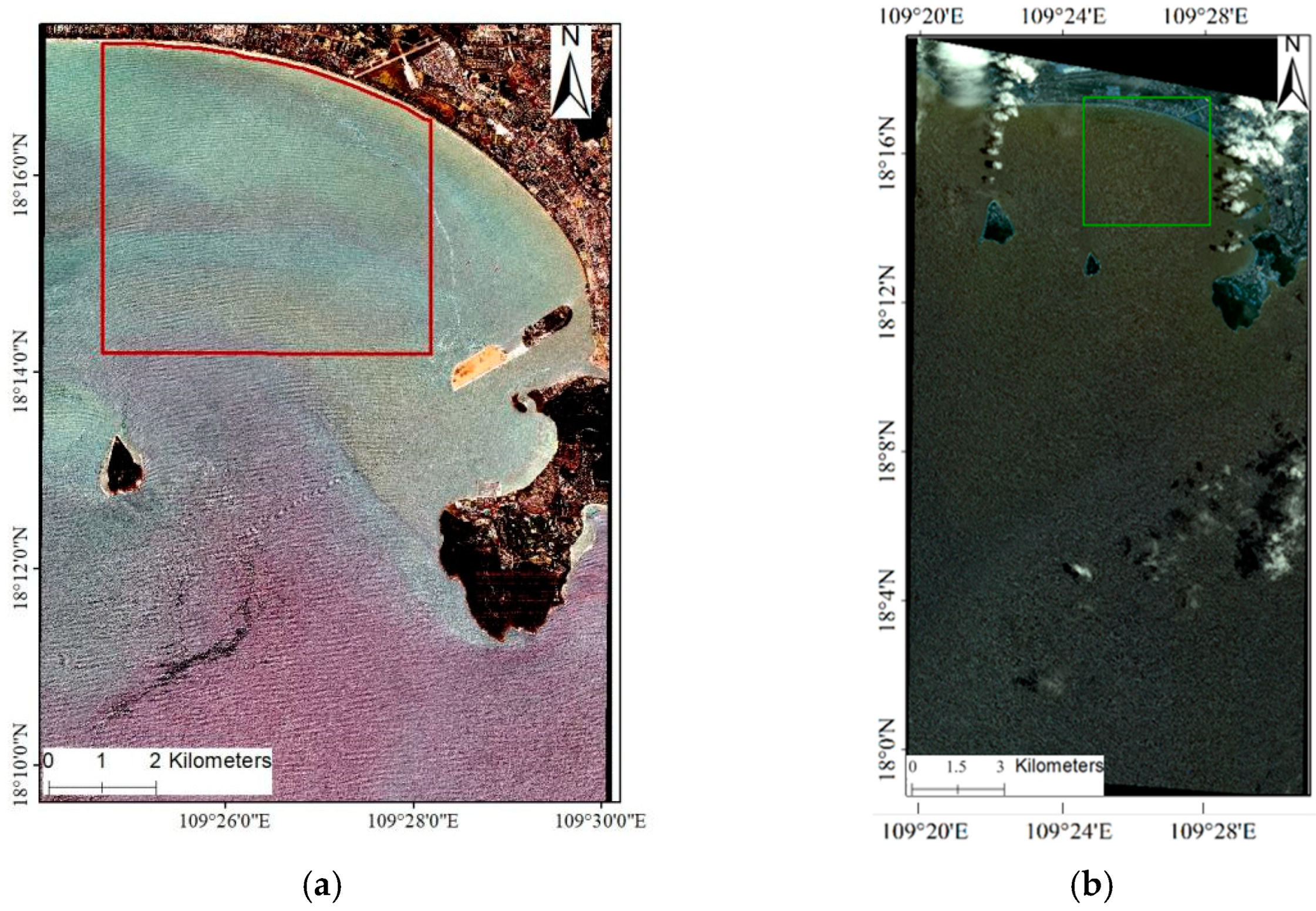
2.1. Study Area
2.2. Study Data
2.3. WBM-ORS
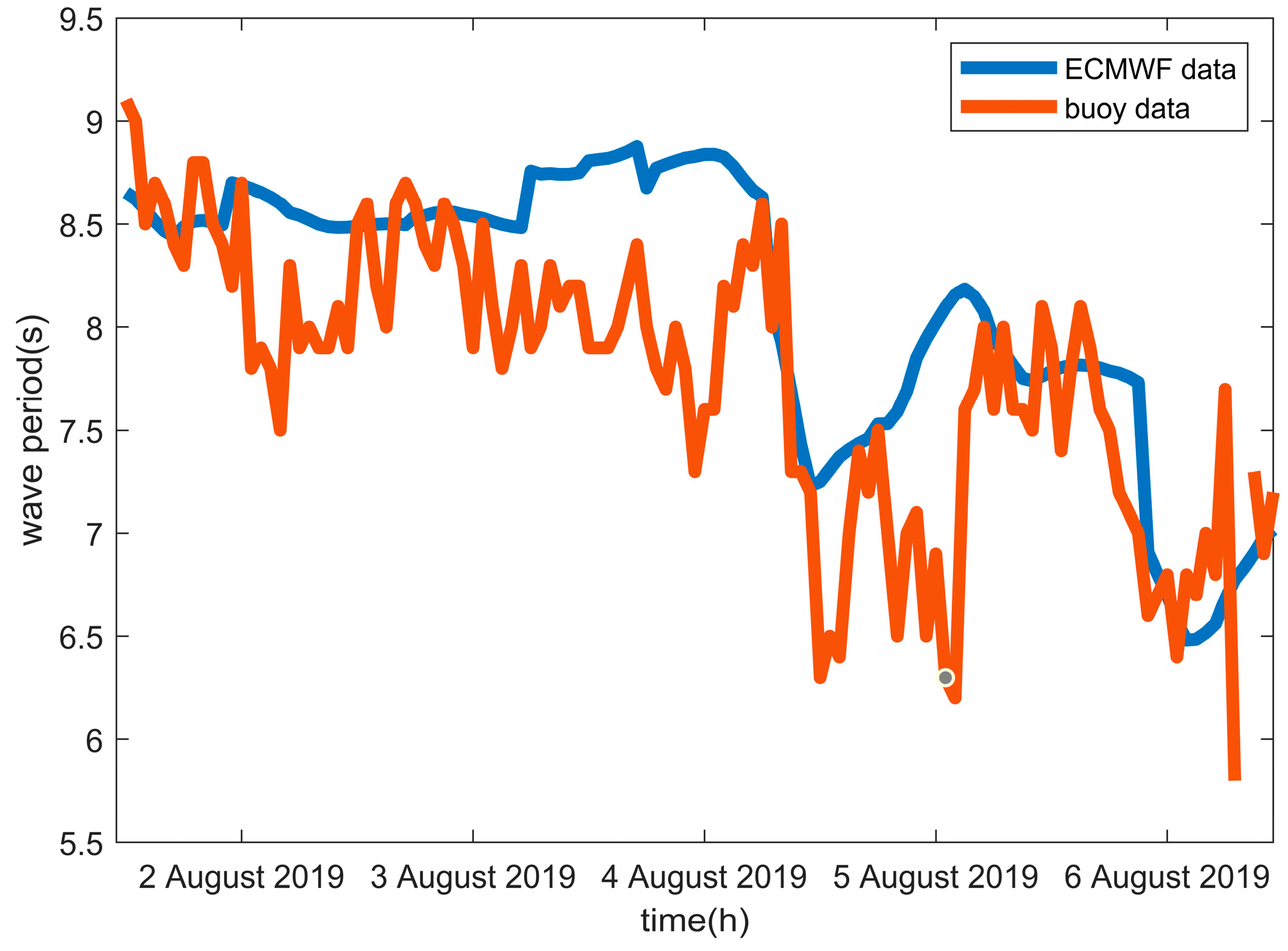
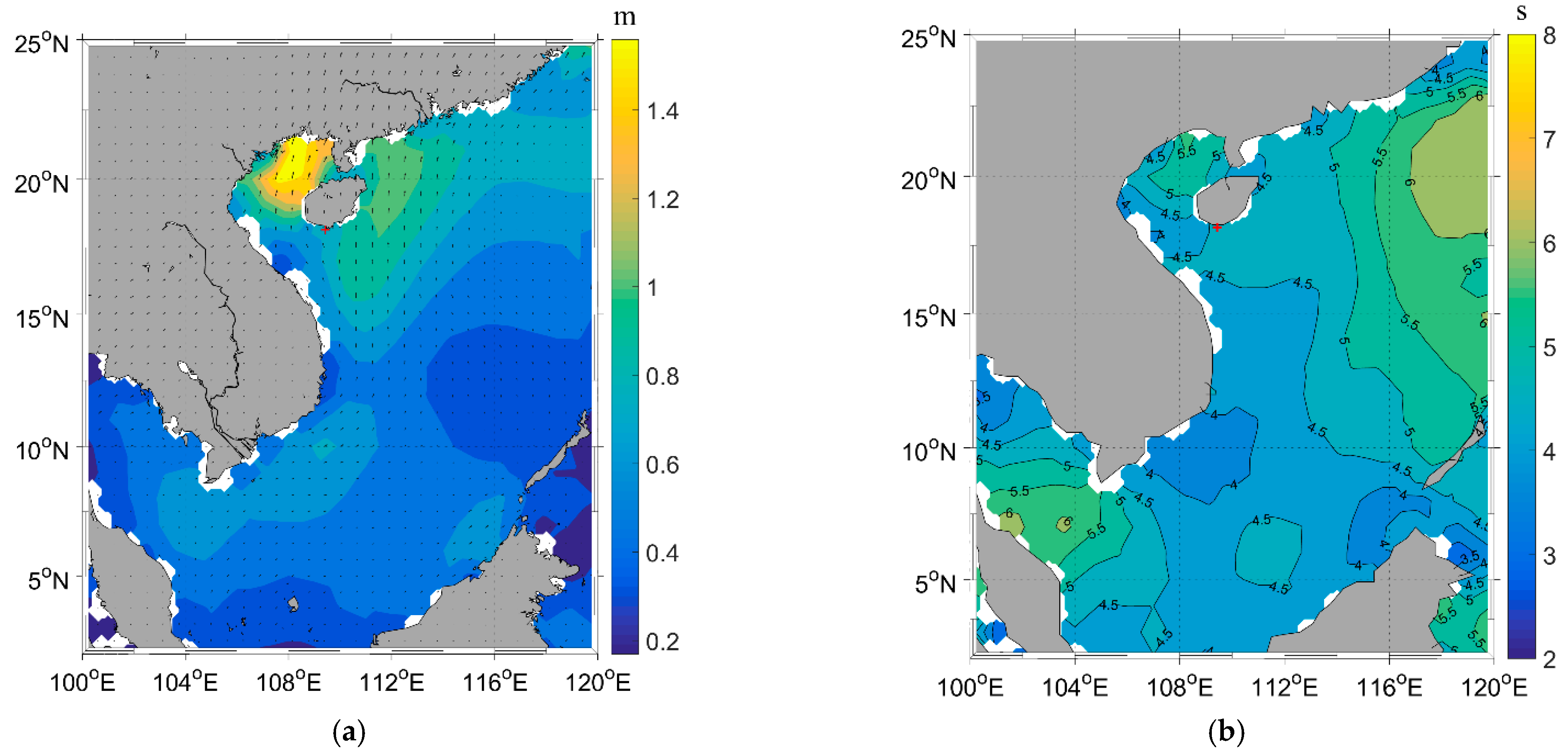
2.4. Wave Period
3. Results
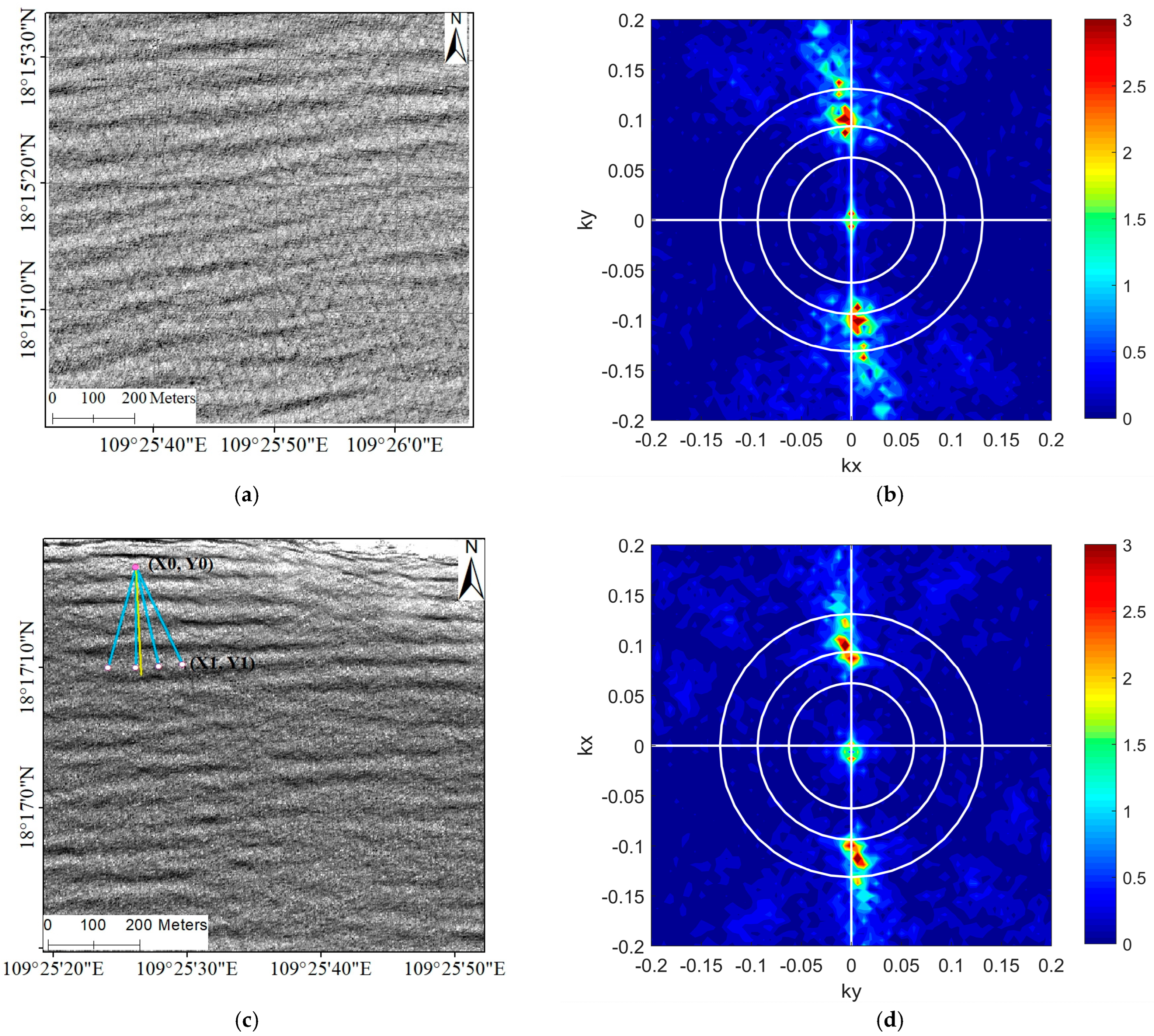
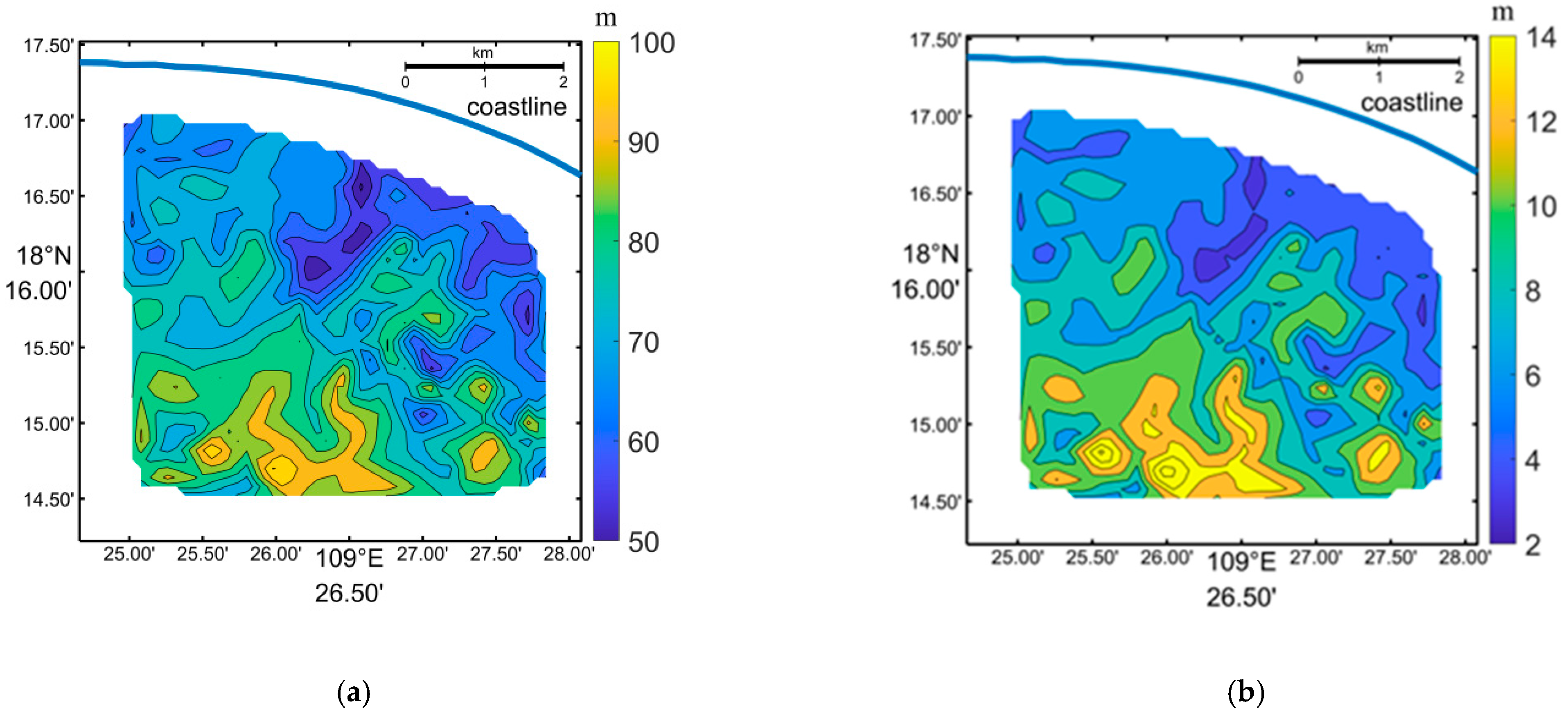
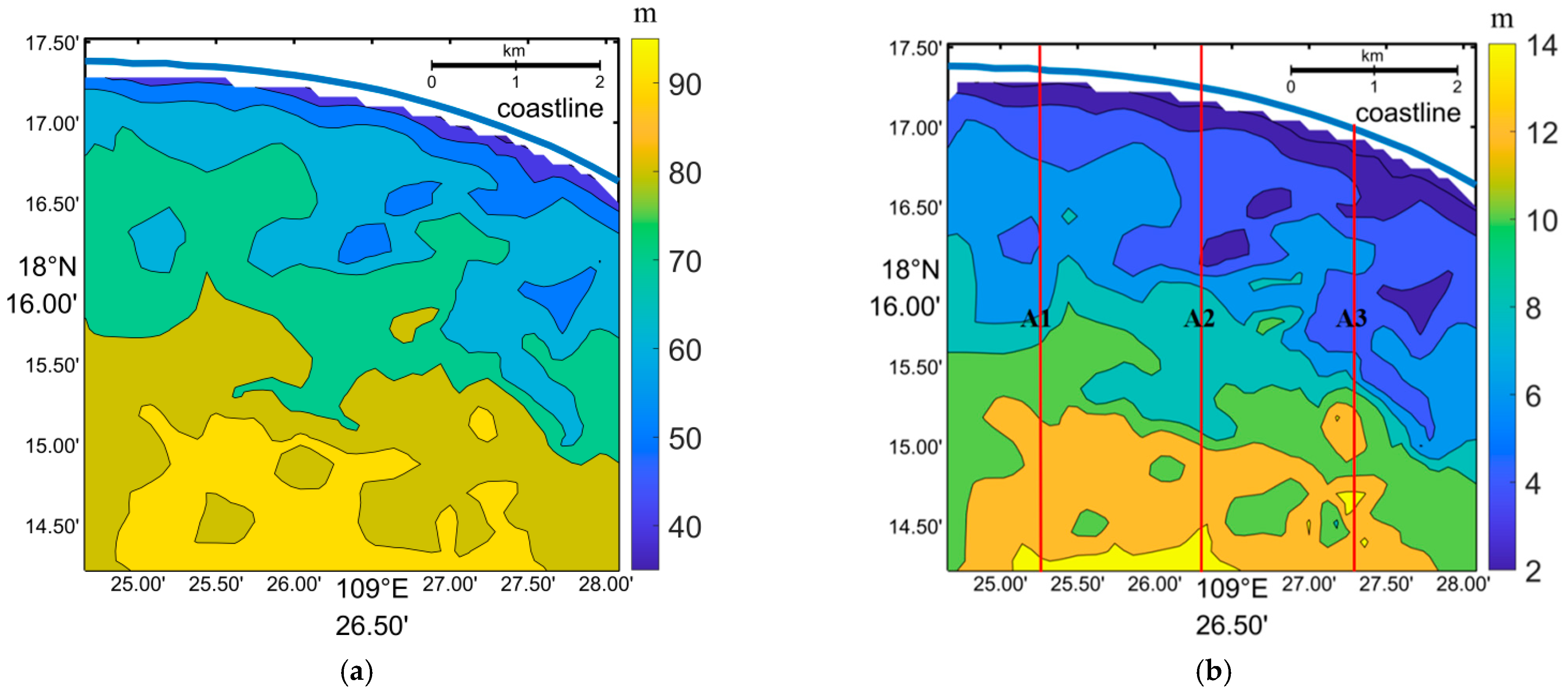
3.1. The Wavelength and Water Depth Inversion from Worldview Data using the FFT Method
3.2. Supplementary Inversions of Wavelength and Water Depth using the SPM Method
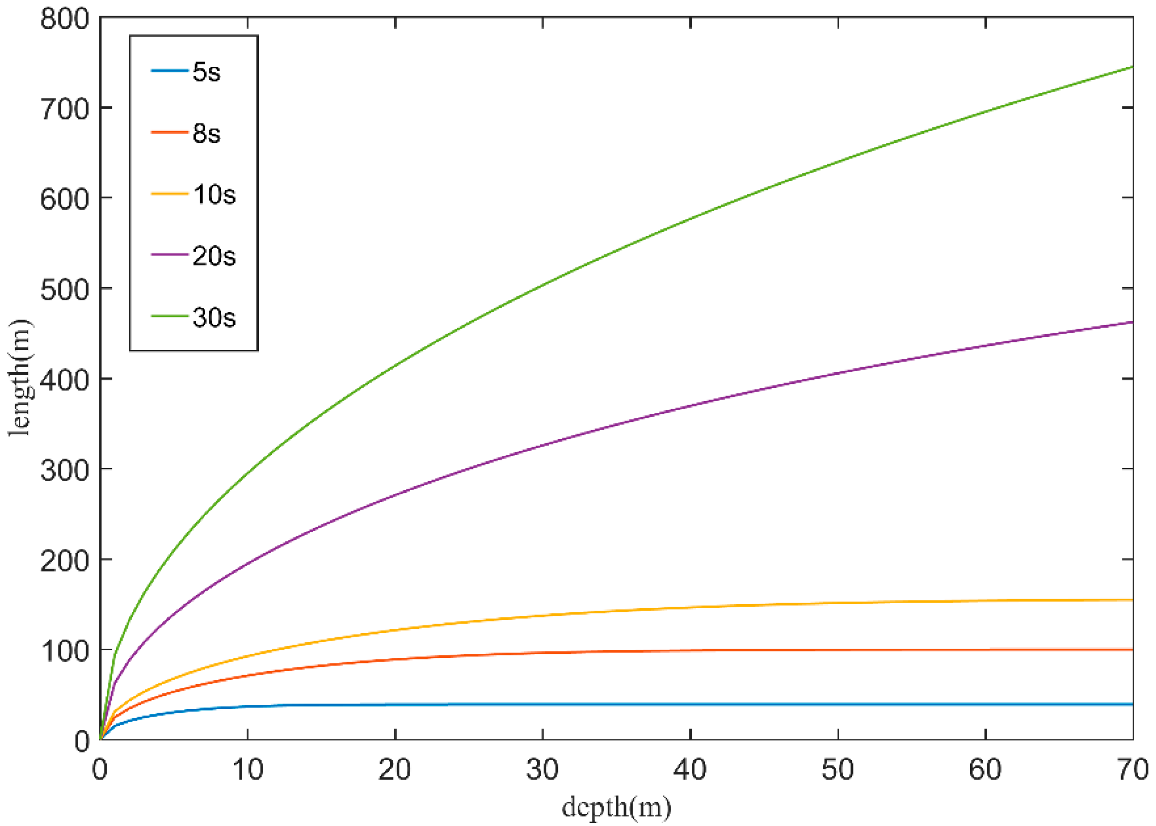
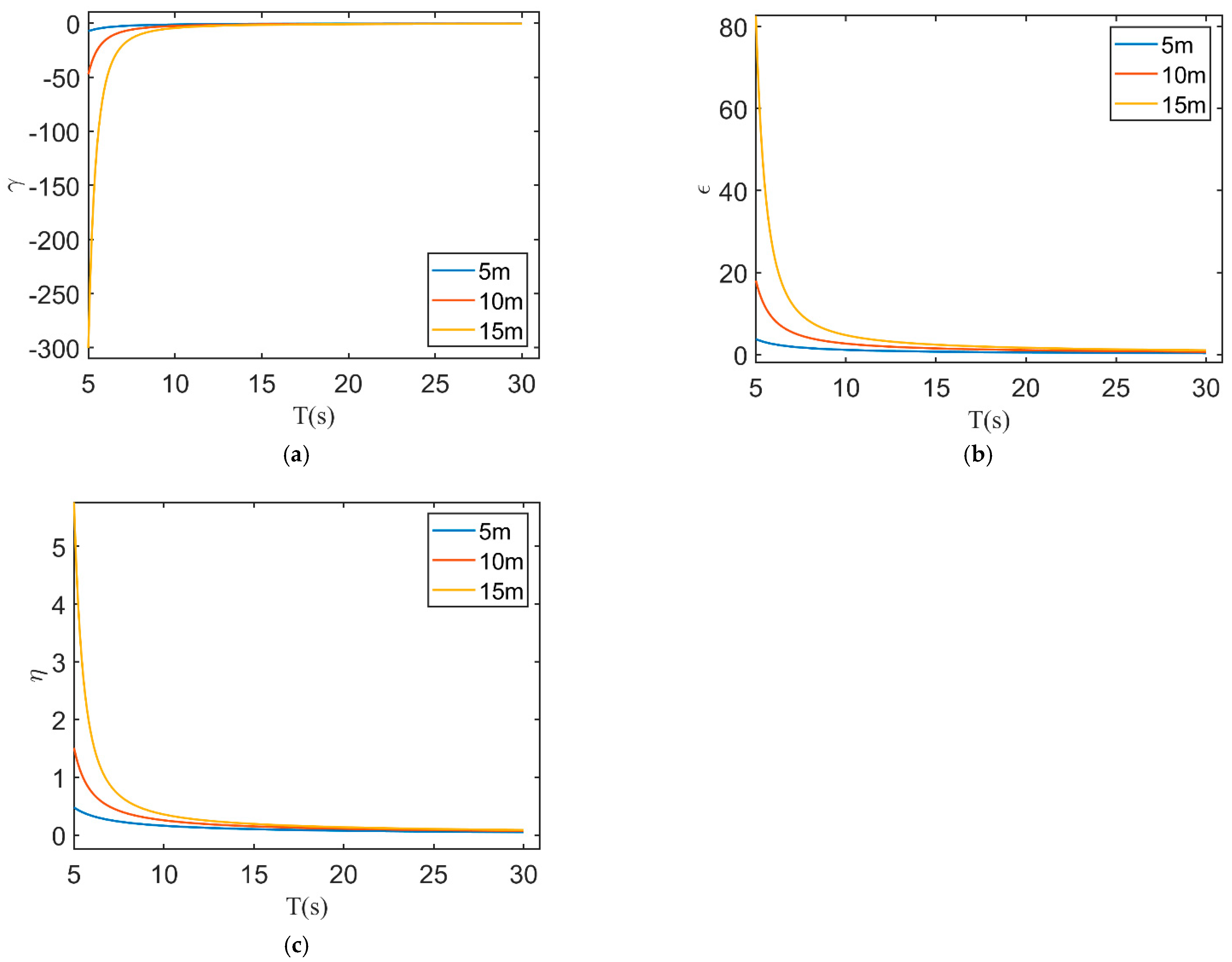
3.3. Assessing Bathymetry Accuracy Affected by Wave Period
4. Discussions
- (1)
- For a given water depth , and a series of periods Ti (i = 1, 2, 3…), calculate wavelength Li using the wave dispersion relationship (Equation (6)).
- (2)
- Then, obtain using and Li.
- (3)
- Repeat step (1) and (2) for different .
5. Conclusions
Author Contributions
Funding
Institutional Review Board Statement
Informed Consent Statement
Data Availability Statement
Conflicts of Interest
References
- Cao, B.; Qiu, Z.; Zhu, S.; Tu, X. Shallow Water Bathymetry through Two-Medium Photogrammetry Using High Resolution Satellite Imagery. Acta Geod. Cartogr. Sin. 2016, 45, 12. [Google Scholar]
- Huang, W.G.; Fu, B.; Zhou, C.B.; Yang, J.S.; Li, D.L. Simulation Study on Optimal Currents and Winds for the Spaceborne SAR Mapping of Sea Bottom Topography. Prog. Nat. Sci. 2000, 10, 859–866. [Google Scholar]
- Kaiguo, F.; Weigen, H.; Mingxia, H.; Bin, F. U Progress on Remote Sensing of the Shallow Sea Bottom Topography by SAR. Remote Sens. Technol. Appl. 2008, 23, 479–485. [Google Scholar]
- Zhou, G.; Li, Y.; Ren, Y.; Sheng, L.; Bai, J. Research of Two-Media Underwater Reefs Depth Measurement Experiment Based on Low-Altitude UAV. Acta Geod. Cartogr. Sin. 2015, 44, 548–554, 562. [Google Scholar]
- Jawak, S.D.; Vadlamani, S.S.; Luis, A.J. A Synoptic Review on Deriving Bathymetry Information Using Remote Sensing Technologies: Models, Methods and Comparisons. Adv. Remote Sens. 2015, 4, 147–162. [Google Scholar] [CrossRef]
- Luan, H.J.; He, Y.R.; Zhu, X.L. Terms of Photogrammetry and Remote Sensing; Xiamen University Press: Xiamen, China, 2022. [Google Scholar]
- Mader, D.; Richter, K.; Westfield, P.; Maas, H.-G. Correction to: Potential of a Non-linear Full-Waveform Stacking Technique in Airborne LiDAR Bathymetry.PFG-Journal of Photogrammetry. Remote Sens. Geoinf. Sci. 2022, 90, 495–496. [Google Scholar] [CrossRef]
- Yang, F.L.; Qi, C.; Su, D.P.; Ding, S.; He, Y.; Ma, Y. An airborne LiDAR bathymetric waveform decomposition method in very shallow water: A case study around Yuanzhi Island in the South China Sea. Int. J. Appl. Earth Obs. Geoinf. 2023, 109, 102788. [Google Scholar] [CrossRef]
- Niroumand-Jadidi, M.; Bovolo, F.; Bruzzone, L. SMART-SDB: Sample-specific multiple band ratio technique for satellite-derived bathymetry. Remote Sens. Environ. 2023, 251, 112091. [Google Scholar] [CrossRef]
- Liu, Y.M.; Zhao, J.; Deng, R.R.; Liang, Y.; Gao, Y.; Chen, Q.; Xiong, L.; Liu, Y.; Tang, Y.; Tang, D. A downscaled bathymetric mapping approach combining multitemporal Landsat-8 and high spatial resolution imagery: Demonstrations from clear to turbid waters. ISPRS J. Photogramm. Remote Sens. 2021, 180, 65–81. [Google Scholar] [CrossRef]
- Santos, D.; Fernández-Fernández, S.; Abreu, T.; Silva, P.A.; Baptista, P. Retrieval of nearshore bathymetry from Sentinel-1 SAR data in high energetic wave coasts: The Portuguese case study. Remote Sens. Appl. Soc. Environ. 2021, 25, 100674. [Google Scholar] [CrossRef]
- Huang, L.; Fan, C.; Meng, J.; Yang, J.; Zhang, J. Shallow sea topography detection using fully Polarimetric Gaofen-3 SAR data based on swell patterns. Acta Oceanol. Sin. 2023, 42, 150–162. [Google Scholar] [CrossRef]
- Zhu, W.; Ye, L.; Qiu, Z.; Luan, K.; He, N.; Wei, Z.; Yang, F.; Yue, Z.; Zhao, S.; Yang, F. Research of the Dual-Band Log-Linear Analysis Model Based on Physics for Bathymetry without In-Situ Depth Data in the South China Sea. Remote Sens. 2021, 13, 4331. [Google Scholar] [CrossRef]
- Liu, Y.; Tang, D.; Deng, R.; Cao, B.; Chen, Q.; Zhang, R.; Qin, Y.; Zhang, S. An Adaptive Blended Algorithm Approach for Deriving Bathymetry from Multispectral Imagery. IEEE J. Sel. Top. Appl. Earth Obs. Remote Sens. 2021, 14, 801–817. [Google Scholar] [CrossRef]
- Zhou, G.; Su, S.; Xu, J.; Tian, Z.; Cao, Q. Bathymetry Retrieval from Spaceborne Multispectral Subsurface Reflectance. IEEE J. Sel. Top. Appl. Earth Obs. Remote Sens. 2023, 16, 2547–2558. [Google Scholar] [CrossRef]
- Qi, J.; Zhang, D.; Ren, Z.; Cui, A.; Yin, F.; Qin, J.; Zhan, J.; Zhu, J. Determination of the Initial Value Ranges of Nonlinear Solutions for a Log Ratio Bathymetric Inversion Model and Bathymetry Retrieval. IEEE J. Sel. Top. Appl. Earth Obs. Remote Sens. 2021, 14, 10875–10888. [Google Scholar] [CrossRef]
- Guo, X.; Qiu, Z.; Shen, W.; Luan, K. Shallow Water Depth Inversion in Longwan Port Based on WorldView-2 Remote Sensing Image. J. Mar. Sci. 2017, 35, 7. [Google Scholar]
- Shen, W.; Wang, J.; Chen, M.; Hao, L.; Wu, Z. Research on Bathymetric Inversion Capability of Different Multispectral Remote Sensing Images in Seaports. Sensors 2023, 23, 1178. [Google Scholar] [CrossRef]
- Shen, W.; Lih, H.; Chen, M.; Xin, L. Evaluation of the bathymetric inversion ability of GF-6 remote sensing images. J. Ocean Technol. 2023, 42, 28–34. [Google Scholar] [CrossRef]
- Ma, Y.; Zhang, H.; Li, X.; Wang, J.; Fan, K. An Exponential Algorithm for Bottom Reflectance Retrieval in Clear Optically Shallow Waters from Multispectral Imagery without Ground Data. Remote Sens. 2021, 13, 1169. [Google Scholar] [CrossRef]
- Zhang, G.; Zhang, W.; Zhu, S. Study on the Water Depth Extractionmethod Using Visible Remote Sensing in the Haikou Bay. Mar. Sci. Bull. 2016, 54–63. [Google Scholar] [CrossRef]
- Chu, M.; Zhang, H. High resolution multispectral remote sensing for shallow sea topography detection and its application in Lingshui Bay, Hainan. In Proceedings of the Second Target Recognition and Artificial Intelligence Summit Forum, Changchun, China, 20–22 August 2019. [Google Scholar] [CrossRef]
- Wang, G.-R.; Li, X.-F.; Wang, J.; Wei, Y.-L.; Zheng, X.-M.; Jiang, T.; Chen, X.-X.; Wan, X.-K.; Wang, Y. Development of a Pixel-Wise Forest Transmissivity Model at Frequencies of 19 GHz and 37 GHz for Snow Depth Inversion in Northeast China. Remote Sens. 2022, 14, 5483. [Google Scholar] [CrossRef]
- Yang, Q.; Chen, J.; Chen, B.; Tao, B. Evaluation and Improvement of No-Ground-Truth Dual Band Algorithm for Shallow Water Depth Retrieval: A Case Study of a Coastal Island. Remote Sens. 2022, 14, 6231. [Google Scholar] [CrossRef]
- Salameh, E.; Frappart, F.; Almar, R.; Baptista, P.; Heygster, G.; Lubac, B.; Raucoules, D.; Almeida, L.P.; Bergsma, E.W.J.; Capo, S.; et al. Monitoring Beach Topography and Nearshore Bathymetry Using Spaceborne Remote Sensing: A Review. Remote Sens. 2019, 11, 2212. [Google Scholar] [CrossRef]
- Bergsma, E.W.J.; Almar, R.; Rolland, A.; Binet, R.; Brodie, K.L.; Bak, A.S. Coastal Morphology from Space: A Showcase of Monitoring the Topography-Bathymetry Continuum. Remote Sens. Environ. 2021, 261, 112469. [Google Scholar] [CrossRef]
- Cox, C.S.; Munk, W.H. Statistics of The Sea Surface Derived from Sun Glitter. J. Mar. Res. 1954, 13, 198–227. [Google Scholar]
- Stockdon, H.F.; Holman, R.A. Estimation of Wave Phase Speed and Nearshore Bathymetry from Video Imagery. J. Geophys. Res. Ocean. 2000, 105, 22015–22033. [Google Scholar] [CrossRef]
- Cao, B.; Deng, R.; Xu, Y.; Cao, B.; Liu, Y.; Zhu, S. Practical Differences Between Photogrammetric Bathymetry and Physics-Based Bathymetry. IEEE Geosci. Remote Sens. Lett. 2022, 19, 8016705. [Google Scholar] [CrossRef]
- Wang, Y. Research Progress of Airborne Laser Bathymetry Technology. J. Geomat. 2014, 39, 6. [Google Scholar]
- Guo, K.; Li, Q.; Mao, Q.; Wang, C.; Zhu, J.; Liu, Y.; Xu, W.; Zhang, D.; Wu, A. Errors of Airborne Bathymetry LiDAR Detection Caused by Ocean Waves and Dimension-Based Laser Incidence Correction. Remote Sens. 2021, 13, 1750. [Google Scholar] [CrossRef]
- Lowell, K.; Calder, B. Assessing Marginal Shallow-Water Bathymetric Information Content of Lidar Sounding Attribute Data and Derived Seafloor Geomorphometry. Remote Sens. 2021, 13, 1604. [Google Scholar] [CrossRef]
- Ghosh, R.; Bovolo, F. An FFT-Based CNN-Transformer Encoder for Semantic Segmentation of Radar Sounder Signal. In Proceedings of the Image and Signal Processing for Remote Sensing XXVIII, Berlin, Germany, 5–8 September 2022; Bruzzone, L., Bovolo, F., Pierdicca, N., Eds.; SPIE: Bellingham, WA, USA, 2022; Volume 12267. [Google Scholar]
- Vesecky, J.F.; Stewart, R.H. The observation of ocean surface phenomena using imagery from the SEASAT synthetic aperture radar: An assessment. J. Geophys. Res. 1982, 87, 3397–3430. [Google Scholar] [CrossRef]
- Rieu, P.; Moreau, T.; Cadier, E.; Raynal, M.; Clerc, S.; Donlon, C.; Borde, F.; Boy, F.; Maraldi, C. Exploiting the Sentinel-3 Tandem Phase Dataset and Azimuth Oversampling to Better Characterize the Sensitivity of SAR Altimeter Sea Surface Height to Long Ocean Waves. Adv. Space Res. 2021, 67, 253–265. [Google Scholar] [CrossRef]
- Leu, L.G.; Chang, H.W. Remotely Sensing in Detecting the Water Depths and Bed Load of Shallow Waters and Their Changes. Ocean Eng. 2005, 32, 1174–1198. [Google Scholar] [CrossRef]
- Li, Y.; Zhang, X.; Cheng, L.; Xie, M.; Cao, K. 3D Wave Simulation Based on a Deep Learning Model for Spatiotemporal Prediction. Ocean Eng. 2022, 263, 112420. [Google Scholar] [CrossRef]
- Liu, J.; Yang, Z.; Liu, Y.; Mu, C. Hyperspectral Remote Sensing Images Deep Feature Extraction Based on Mixed Feature and Convolutional Neural Networks. Remote Sens. 2021, 13, 2599. [Google Scholar] [CrossRef]
- Wang, Z.; Zhao, Y.; Chen, J. Multi-Scale Fast Fourier Transform Based Attention Network for Remote-Sensing Image Super-Resolution. IEEE J. Sel. Top. Appl. Earth Obs. Remote Sens. 2023, 16, 2728–2740. [Google Scholar] [CrossRef]
- Poupardin, A.; Idier, D.; Michele, M.D.; Raucoules, D. Water Depth Inversion from a Single SPOT-5 Dataset. IEEE Trans. Geosci. Remote Sens. 2016, 54, 2329–2342. [Google Scholar] [CrossRef]
- Li, J.; Zhang, H.; Hou, P.; Fu, B.; Zheng, G. Mapping the Bathymetry of Shallow Coastal Water Using Single-Frame Fine-Resolution Optical Remote Sensing Imagery. Acta Oceanol. Sin. 2016, 35, 60–66. [Google Scholar] [CrossRef]
- Danilo, C.; Melgani, F. Wave Period and Coastal Bathymetry Using Wave Propagation on Optical Images. IEEE Trans. Geosci. Remote Sens. 2016, 54, 6307–6319. [Google Scholar] [CrossRef]
- Benshila, R.; Thoumyre, G.; Najar, M.A.; Abessolo, G.; Almar, R.; Bergsma, E.; Hugonnard, G.; Labracherie, L.; Lavie, B.; Ragonneau, T.; et al. A Deep Learning Approach for Estimation of the Nearshore Bathymetry. J. Coast. Res. 2020, 95, 1011–1015. [Google Scholar] [CrossRef]
- Najar, M.A.; Benshila, R.; Bennioui, Y.; Thoumyre, G.; Almar, R.; Bergsma, E.W.J.; Delvit, J.-M.; Wilson, D.G. Coastal Bathymetry Estimation from Sentinel-2 Satellite Imagery: Comparing Deep Learning and Physics-Based Approaches. Remote Sens. 2022, 14, 1196. [Google Scholar] [CrossRef]
- Collins, A.M.; Geheran, M.P.; Hesser, T.J.; Bak, A.S.; Brodie, K.L.; Farthing, M.W. Development of a Fully Convolutional Neural Network to Derive Surf-Zone Bathymetry from Close-Range Imagery of Waves in Duck, NC. Remote Sens. 2021, 13, 4907. [Google Scholar] [CrossRef]
- Almar, R.; Bergsma, E.W.J.; Brodie, K.L.; Bak, A.S.; Artigues, S.; Lemai-Chenevier, S.; Cesbron, G.; Delvit, J.-M. Coastal Topo-Bathymetry from a Single-Pass Satellite Video: Insights in Space-Videos for Coastal Monitoring at Duck Beach (NC, USA). Remote Sens. 2022, 14, 1529. [Google Scholar] [CrossRef]
- Gawehn, M.; Almar, R.; Bergsma, E.W.J.; de Vries, S.; Aarninkhof, S. Depth Inversion from Wave Frequencies in Temporally Augmented Satellite Video. Remote Sens. 2022, 14, 1847. [Google Scholar] [CrossRef]
- Almar, R.; Bergsma, E.W.J.; Thoumyre, G.; Baba, M.W.; Cesbron, G.; Daly, C.; Garlan, T.; Lifermann, A. Global Satellite-Based Coastal Bathymetry from Waves. Remote Sens. 2021, 13, 4628. [Google Scholar] [CrossRef]
- Abileah, R.; Gómez-Enri, J.; Scozzari, A.; Vignudelli, S. Coherent Ranging with Envisat Radar Altimeter: A New Perspective in Analyzing Altimeter Data Using Doppler Processing. Remote Sens. Environ. 2013, 139, 271–276. [Google Scholar] [CrossRef]
- Li, R. On the Relationships of Various Wind Wave Periods. Trans. Oceanol. Limnol. 2007, 13–18. [Google Scholar] [CrossRef]
- Ma, X.; Duan, W.; Huang, L.; Qin, Y.; Yin, H. Phase-Resolved Wave Prediction for Short Crest Wave Fields Using Deep Learning. Ocean Eng. 2022, 262, 112170. [Google Scholar] [CrossRef]
- Zhao, D.; Xing, H.; Wang, H.; Zhang, H.; Liang, X.; Li, H. Sea-Surface Small Target Detection Based on Four Features Extracted by FAST Algorithm. J. Mar. Sci. Eng. 2023, 11, 339. [Google Scholar] [CrossRef]
- Shen, S.M.; Zhu, S.X.; Kang, Y.Y.; Zhang, W.J.; Cao, G.S. Simulation analysis for remote sensing inversion of wavelength and water depth by the Fast Fourier Transform method. J. East China Norm. Univ. (Nat. Sci.) 2019, 208, 184–194. [Google Scholar] [CrossRef]
- Li, Y.; Wang, P.; Li, Y.; Li, X. Evaluation and Comparison of Water Quality of Sanya Bay. Anim. Husb. Feed. Sci. 2014, 35, 3–7. [Google Scholar] [CrossRef]
- Bendat, J.; Piersol, A. Random Data: Analysis and Measurement Procedures: Fourth Edition. Meas. Sci. Technol. 2010, 11, 1825. [Google Scholar] [CrossRef]
- Gao, C.; Hu, M.X.; Wu, Z.J. The mechanism of blackening beach in Sanya Bay: The interaction between iron oxides and organic matter. Mar. Geol. Front. 2022, 38, 28–36. [Google Scholar] [CrossRef]
- Mao, L.J.; Zhang, Y.Z.; Zhang, Z.K.; Wei, L.; Ji, X.M.; Zhu, D.K. Characteristics of sedimentary environments in Sanya Bay of Hainan Island. Mar. Geol. Quat. Geol. 2007, 27, 17–22, (In Chinese with English Abstract). [Google Scholar]
- Su, J.L. Overview of the South China Sea circulation and its influence on the coastal physical oceanography outside the Pearl River Estuary. Cont. Shelf Res. 2004, 24, 1745–1760. [Google Scholar] [CrossRef]
- Han, L.; Ji, Q.; Jia, X.; Liu, Y.; Han, G.; Lin, X. Significant wave Height Prediction in the South China Sea Based on the ConvLSTM Algorithm. J. Mar. Sci. Eng. 2022, 10, 1683. [Google Scholar] [CrossRef]
- Wang, B.; Huang, F.; Wu, Z.W.; Yang, J.; Fu, X.H.; Kikuchi, K. Multi-scale climate variability of the South China Sea monsoon: A review. Dyn. Atmos. Ocean. 2009, 47, 15–37. [Google Scholar] [CrossRef]


| Time (Year/Month /Day) | Correlation Coefficients between Water Depth and Reflectance (or Band Ratio) | |||||||||
|---|---|---|---|---|---|---|---|---|---|---|
| Blue | Green | Red | NIR | Blue/Green | Blue/Red | Blue/NIR | Green/Red | Green/NIR | Red /NIR | |
| 27 September 2014 | 0.18 | −0.42 | 0.63 | 0.57 | 0.58 | −0.41 | −0.4 | −0.57 | −0.91 | −0.93 |
| 26 June 2015 | 0.07 | −0.14 | 0.01 | 0.01 | 0.24 | 0.14 | 0.1 | −0.3 | −0.75 | −0.7 |
| 30 September 2015 | −0.23 | −0.32 | −0.24 | −0.25 | −0.11 | −0.36 | −0.33 | −0.07 | −0.88 | −0.88 |
| 17 November 2015 | −0.35 | −0.5 | 0.21 | 0.14 | −0.33 | −0.45 | −0.45 | 0.45 | −0.87 | −0.9 |
| 6 September 2018 | −0.64 | −0.67 | −0.63 | −0.63 | −0.72 | −0.73 | −0.72 | 0.78 | −0.55 | −0.75 |
| 9 July 2020 | −0.47 | −0.68 | −0.49 | −0.33 | −0.23 | −0.49 | −0.52 | 0.05 | −0.85 | −0.87 |
| 2 February 2021 | −0.26 | −0.47 | −0.23 | −0.16 | −0.07 | −0.09 | −0.12 | 0.57 | −0.89 | −0.86 |
| 30 September 2021 | −0.65 | −0.81 | −0.76 | −0.72 | −0.75 | −0.75 | −0.76 | 0.55 | −0.84 | −0.92 |
| 3 December 2021 | −0.57 | −0.79 | −0.76 | −0.69 | −0.2 | −0.49 | −0.57 | 0.03 | −0.78 | −0.88 |
| Time (Year/Month/Day) | Reflectance Ratio (X) | Inversion Formula | Bathymetry Error (%) |
|---|---|---|---|
| 27 September 2014 | Red/NIR | Y = −21.3401 lnX + 6.0506 | 15.8 |
| 26 June 2015 | Red/NIR | Y = −44.9909 lnX + 14.5112 | 18.1 |
| 30 September 2015 | Green/NIR | Y = −26.048 lnX + 6.7006 | 14.8 |
| 17 November 2015 | Green/Red | Y = 10.7541 X − 10.8267 | 26.3 |
| 6 September 2018 | Green/NIR | Y = −21.6731 lnX + 9.8358 | 15.0 |
| 9 July 2020 | Red/NIR | Y = −15.5219 lnX + 7.3466 | 17.0 |
| 2 February 2021 | Green/NIR | Y = −28.4931 lnX + 8.0998 | 19.9 |
| 30 September 2021 | Red/NIR | Y = −11.1087 lnX + 4.8556 | 15.6 |
| 3 December 2021 | Green/NIR | Y = −19.9928 lnX + 7.5075 | 16.3 |
Disclaimer/Publisher’s Note: The statements, opinions and data contained in all publications are solely those of the individual author(s) and contributor(s) and not of MDPI and/or the editor(s). MDPI and/or the editor(s) disclaim responsibility for any injury to people or property resulting from any ideas, methods, instructions or products referred to in the content. |
© 2023 by the authors. Licensee MDPI, Basel, Switzerland. This article is an open access article distributed under the terms and conditions of the Creative Commons Attribution (CC BY) license (https://creativecommons.org/licenses/by/4.0/).
Share and Cite
Liu, M.; Zhu, S.; Cheng, S.; Zhang, W.; Cao, G. Nearshore Depth Estimation Using Fine-Resolution Remote Sensing of Ocean Surface Waves. Sensors 2023, 23, 9316. https://doi.org/10.3390/s23239316
Liu M, Zhu S, Cheng S, Zhang W, Cao G. Nearshore Depth Estimation Using Fine-Resolution Remote Sensing of Ocean Surface Waves. Sensors. 2023; 23(23):9316. https://doi.org/10.3390/s23239316
Chicago/Turabian StyleLiu, Mengyuan, Shouxian Zhu, Shanling Cheng, Wenjing Zhang, and Guangsong Cao. 2023. "Nearshore Depth Estimation Using Fine-Resolution Remote Sensing of Ocean Surface Waves" Sensors 23, no. 23: 9316. https://doi.org/10.3390/s23239316
APA StyleLiu, M., Zhu, S., Cheng, S., Zhang, W., & Cao, G. (2023). Nearshore Depth Estimation Using Fine-Resolution Remote Sensing of Ocean Surface Waves. Sensors, 23(23), 9316. https://doi.org/10.3390/s23239316