
Study of the Precise Determination of Pipeline Geometries Using UAV Scanning Compared to Terrestrial Scanning, Aerial Scanning and UAV Photogrammetry


Abstract
:1. Introduction
2. Literature Review
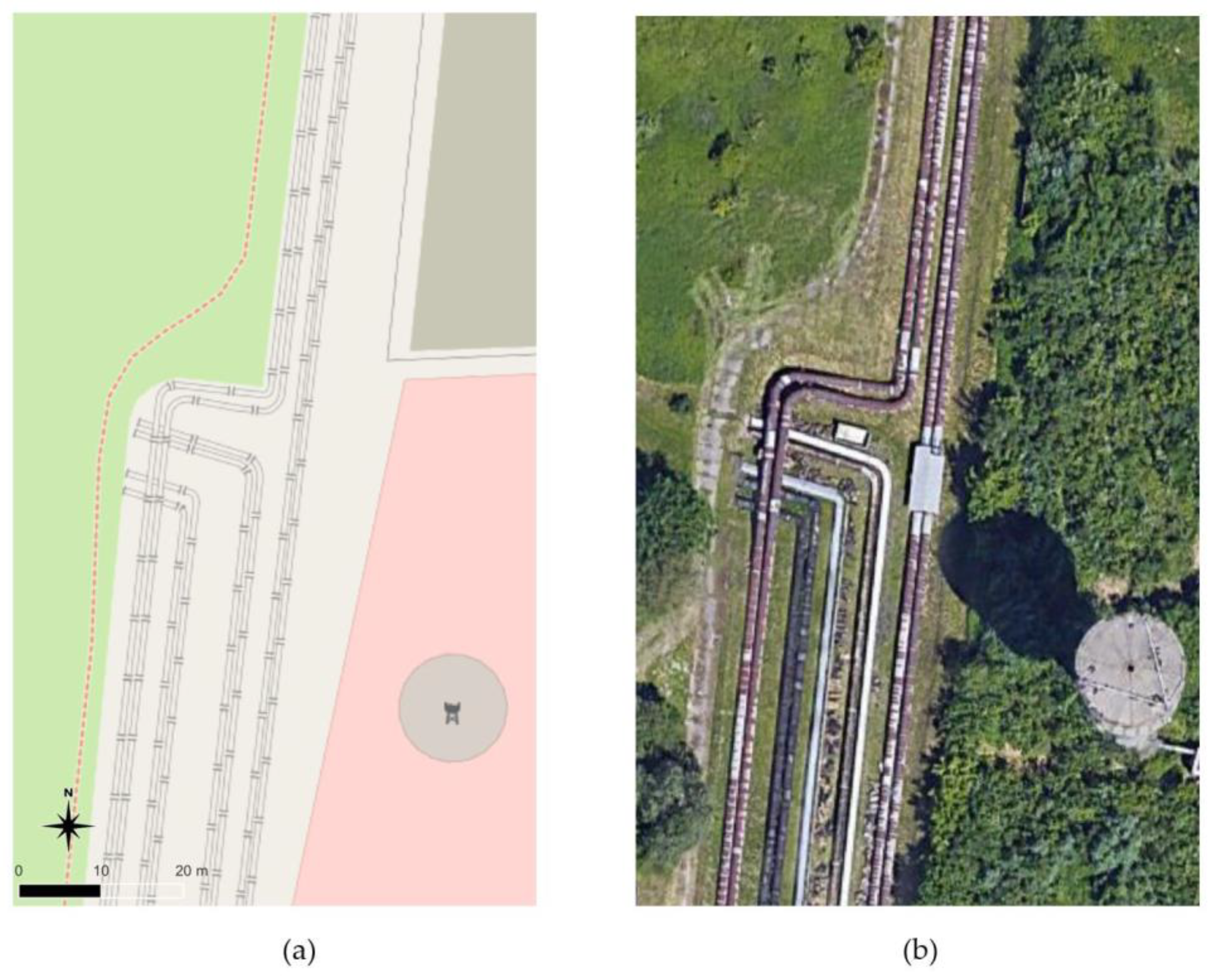
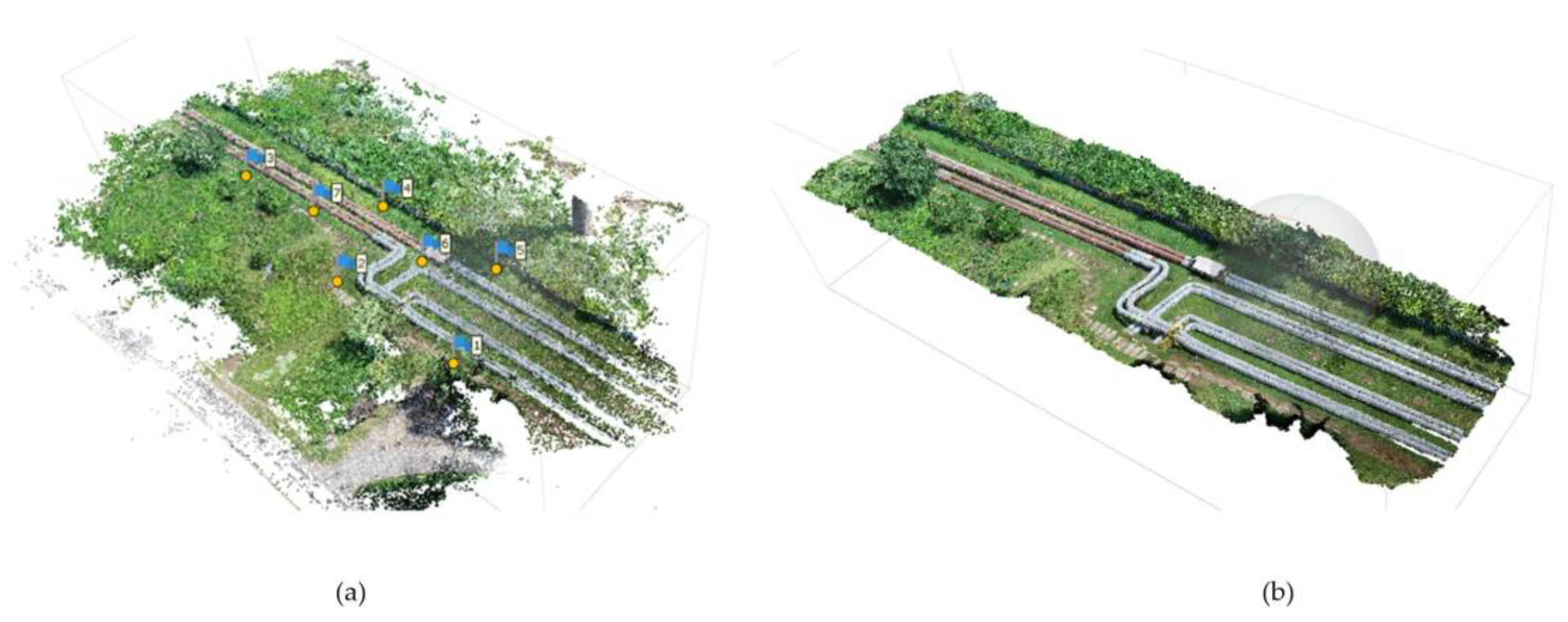
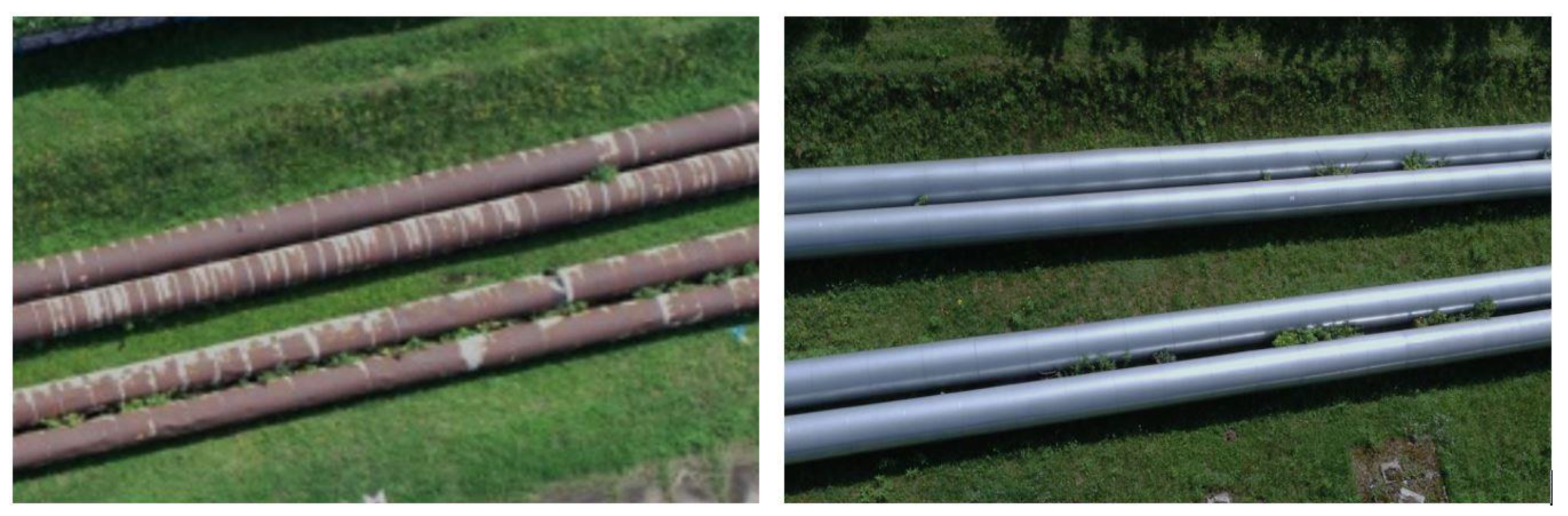
3. Description of the Experiment
- TLS data processing
- ULS data processing
- ALS data processing
- SfM data processing
- registration of ALS, ULS and SfM clouds with the reference TLS cloud
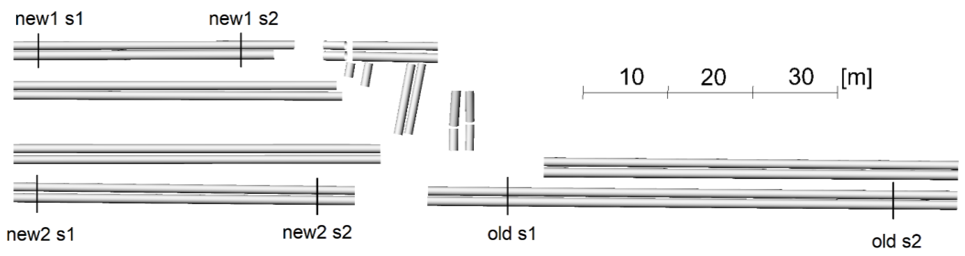
- creating pipe models from TLS data
- analyses of cloud deviations from pipe models
4. TLS, ULS, ALS, SfM Measurements
4.1. Terrestrial Laser Scanning Data
4.2. UAV Scanning Data
4.3. Airborne Laser Scanning Data
4.4. UAV Photogrammetric Data
5. Registration of Point Clouds from All Measurement Methods
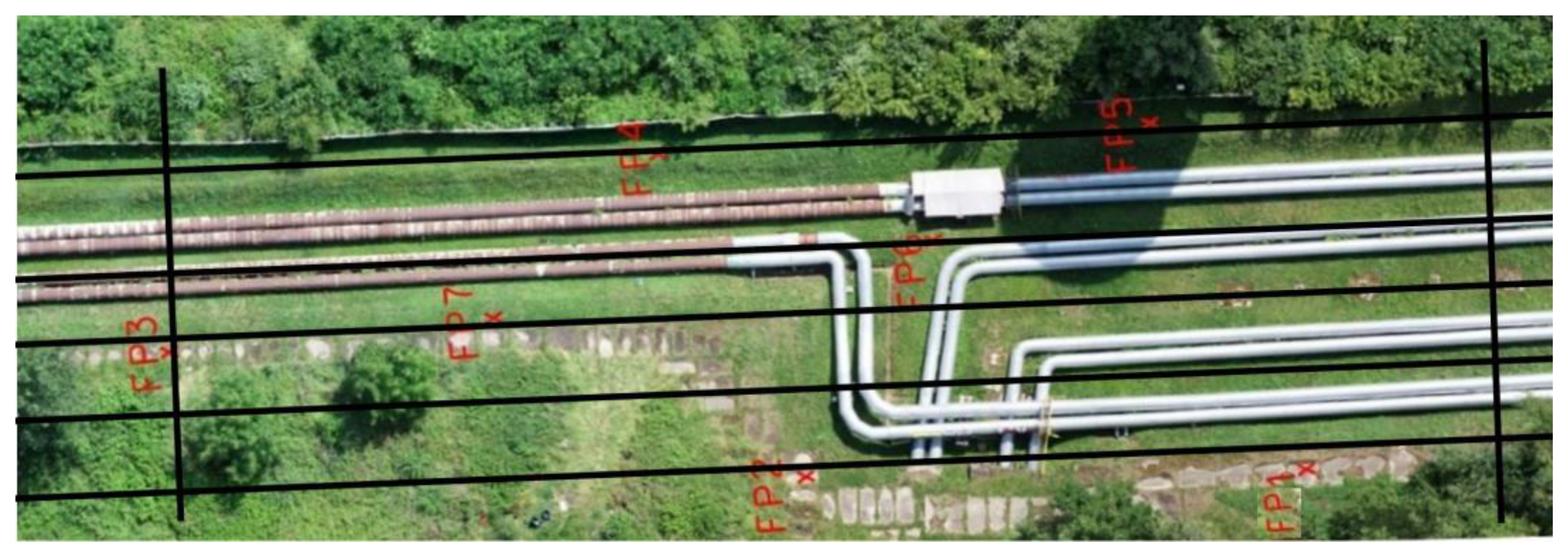
6. Preparation of Models for Analysis
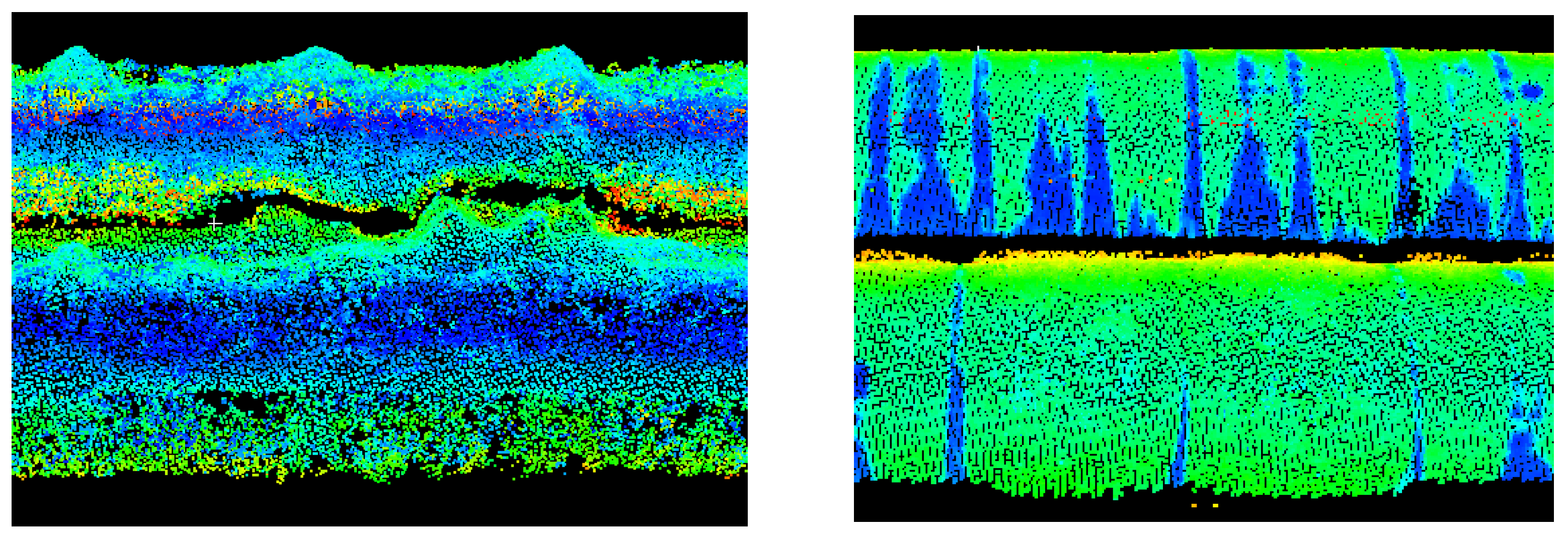
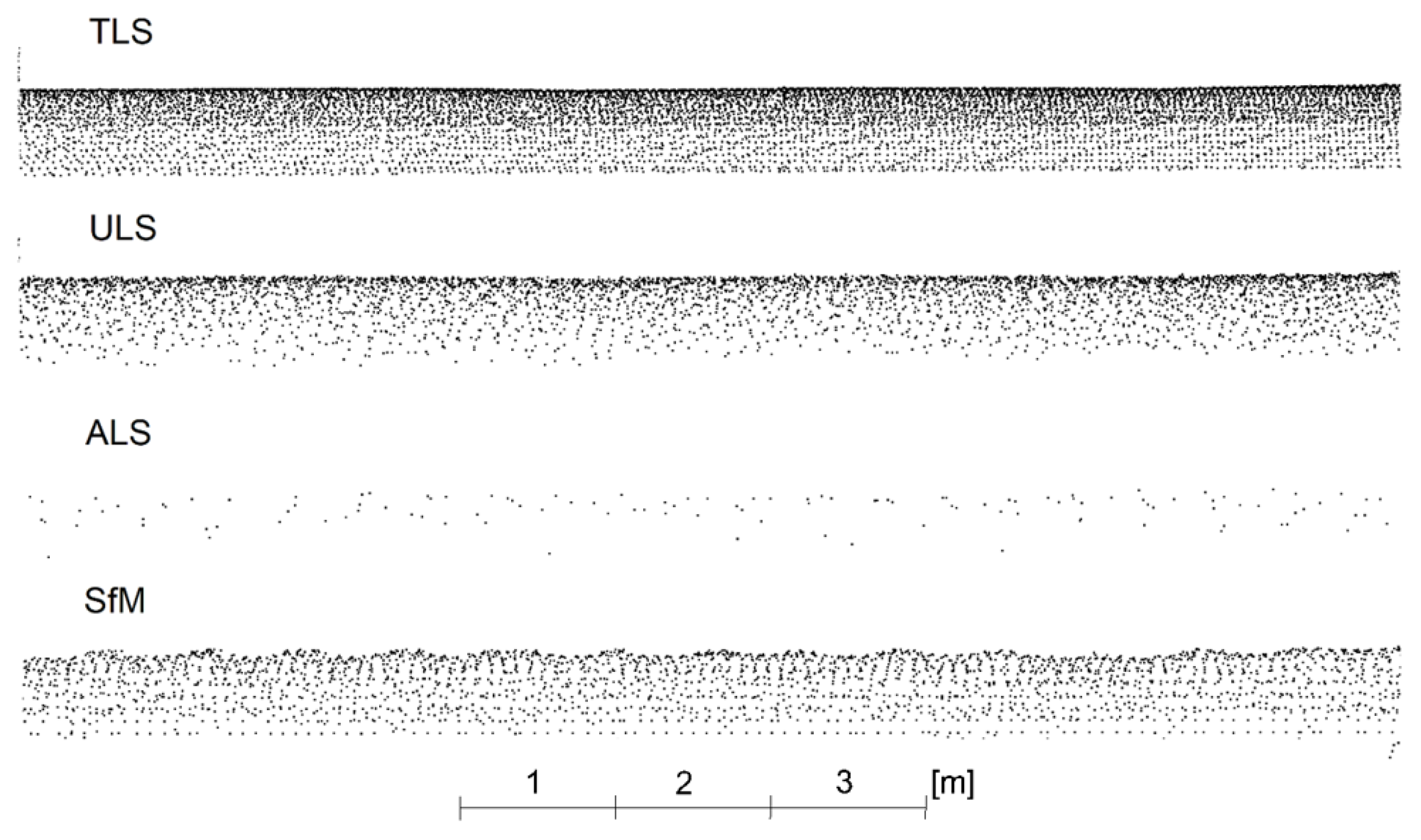
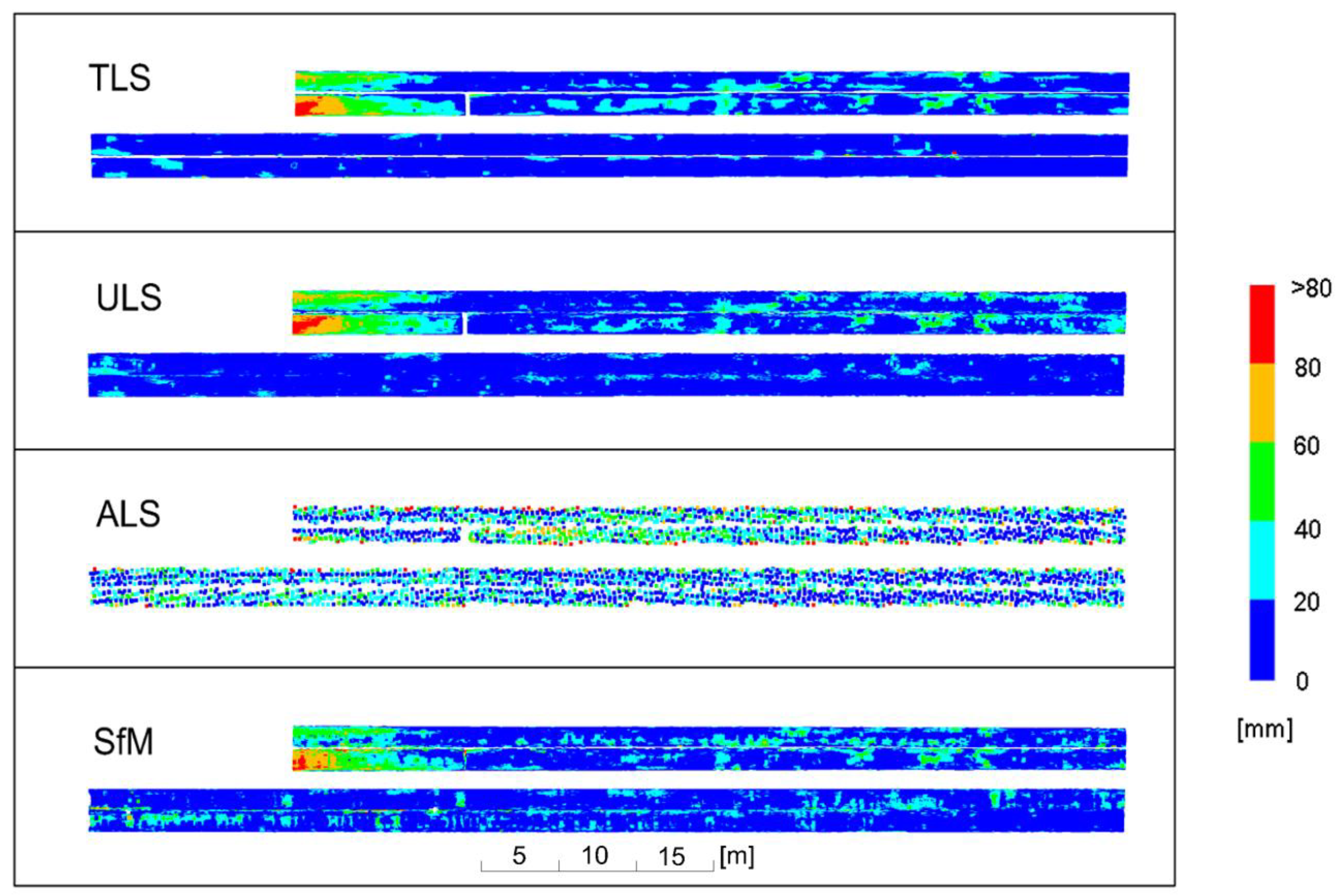
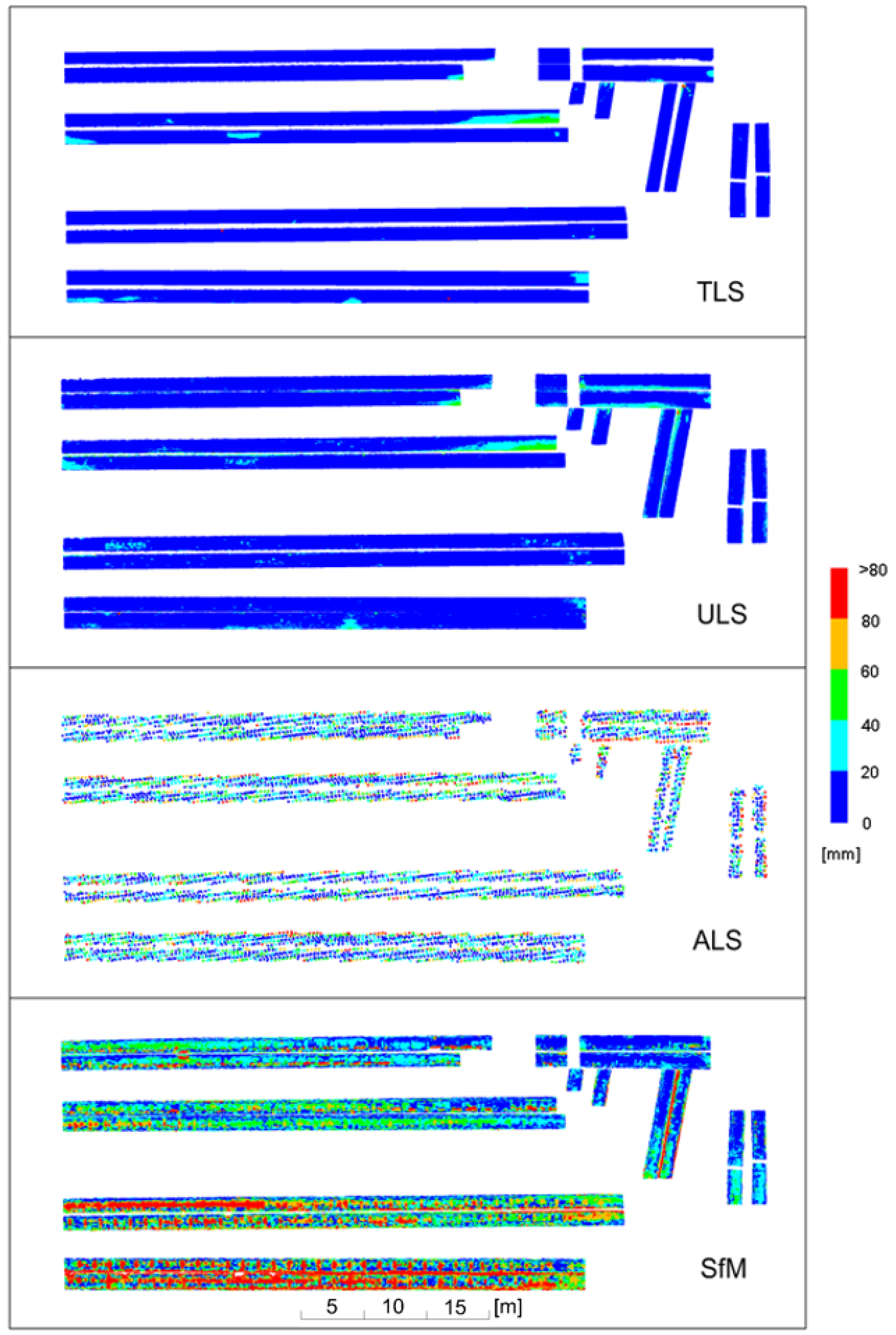
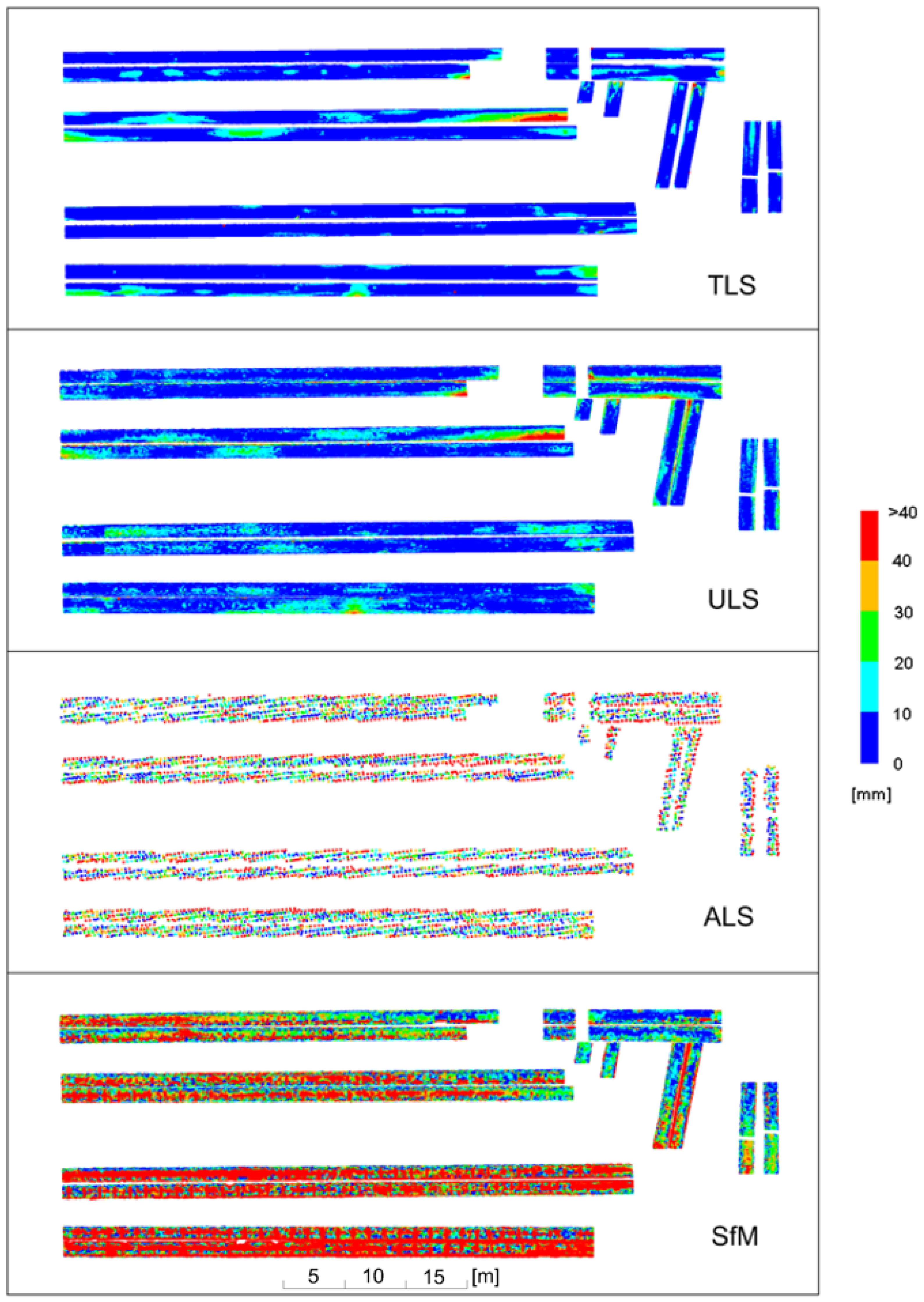
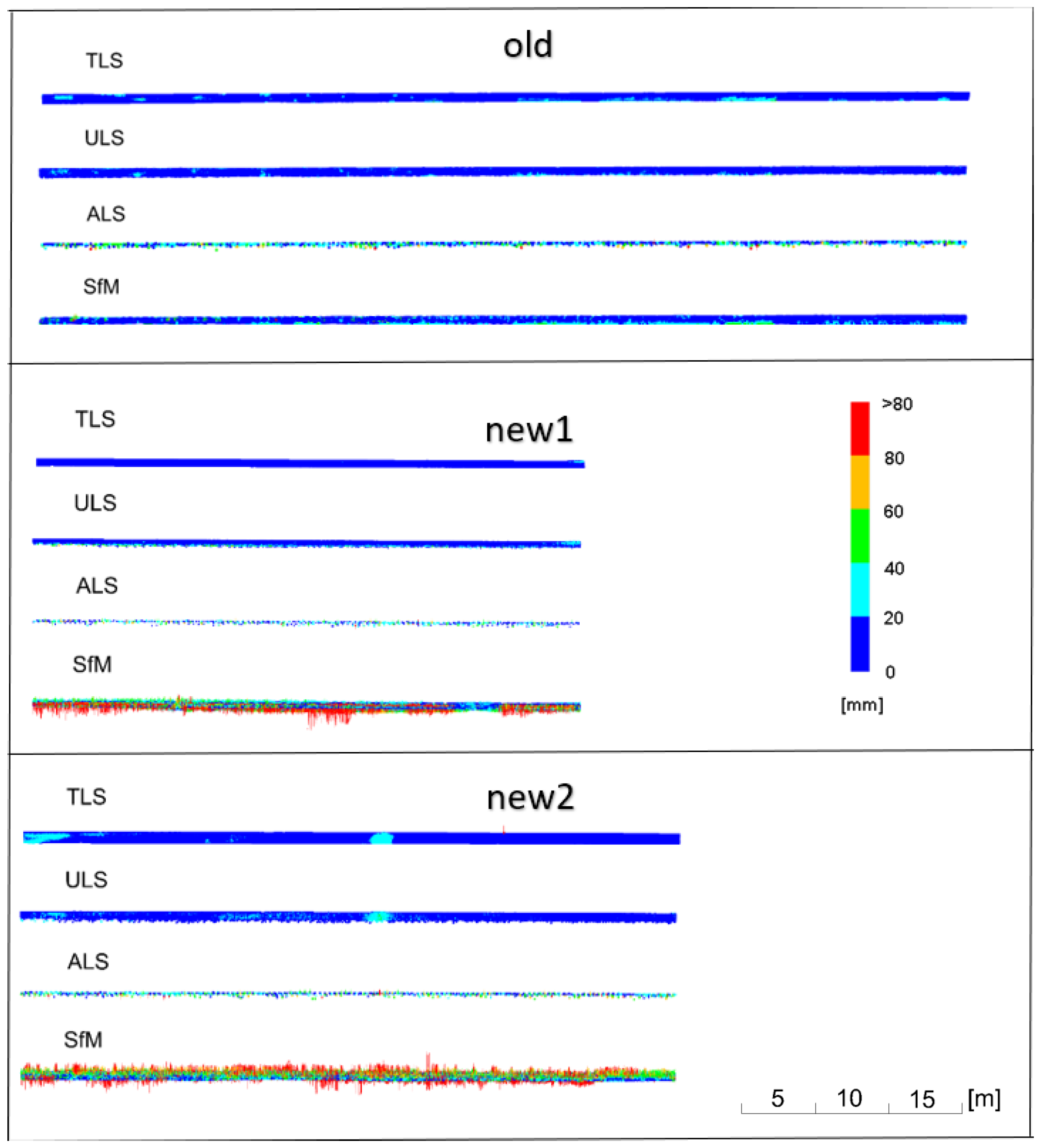
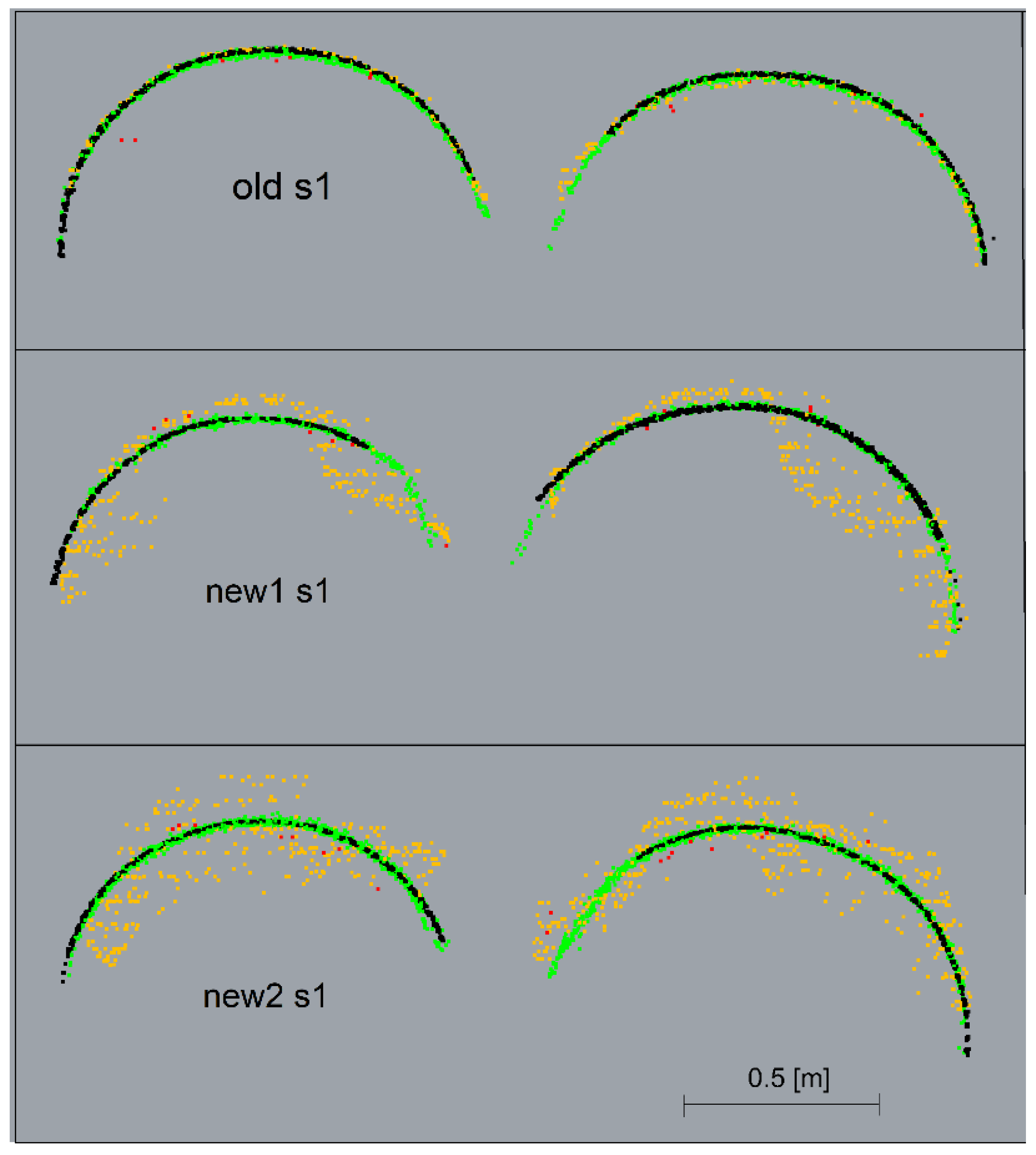
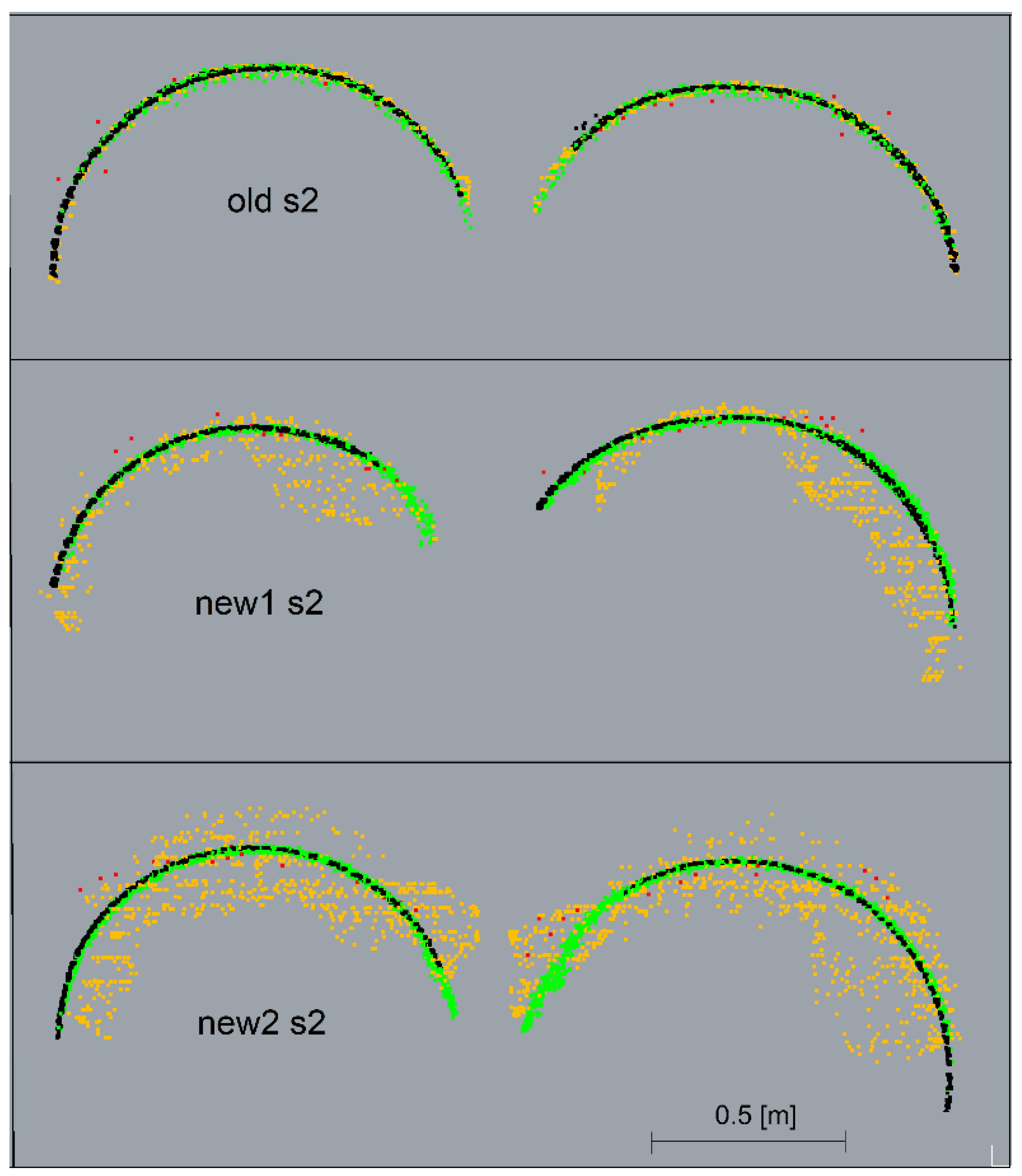
7. Analysis of Results
8. Conclusions
Author Contributions
Funding
Institutional Review Board Statement
Informed Consent Statement
Data Availability Statement
Acknowledgments
Conflicts of Interest
References
- Kawashima, K.; Kanai, S.; Date, H. Automatic recognition of piping system from large-scale terrestrial laser scan data. Int. Arch. Photogramm. Remote Sens. Spat. Inf. Sci. 2012, 38, 283–288. [Google Scholar] [CrossRef]
- Vezočnik, R.; Ambrožič, T.; Sterle, O.; Bilban, G.; Pfeifer, N.; Stopar, B. Use of Terrestrial Laser Scanning Technology for Long Term High Precision Deformation Monitoring. Sensors 2009, 9, 9873–9895. [Google Scholar] [CrossRef] [PubMed]
- Shen, Y.; Lindenbergh, R.; Wang, J. Change Analysis in Structural Laser Scanning Point Clouds: The Baseline Method. Sensors 2016, 17, 26. [Google Scholar] [CrossRef] [PubMed]
- Shults, R.; Annenkov, A.; Seitkazina, G.; Soltabayeva, S.; Kozhayev, Z.; Khailak, A.; Nikitenko, K.; Sossa, B.; Kulichenko, N. Analysis of the displacements of pipeline overpasses based on geodetic monitoring results. Geod. Geodyn. 2022, 13, 50–71. [Google Scholar] [CrossRef]
- Cang, G.H.; Yue, J.P. Effect of distance and incidence angle on laser intensity data of building materials. Appl. Mech. Mater. 2014, 638–640, 2137–2140. [Google Scholar] [CrossRef]
- Costantino, D.; Angelini, M.G. Qualitative and quantitative evaluation of the luminance of laser scanner radiation for the classification of materials. Int. Arch. Photogramm. Remote Sens. Spat. Inf. Sci. 2013, 40, 207–212. [Google Scholar] [CrossRef]
- Tan, K.; Cheng, X.; Wynne, R.H.; Thenkabail, P.S. Correction of Incidence Angle and Distance Effects on TLS Intensity Data Based on Reference Targets. Remote Sens. 2016, 8, 251. [Google Scholar] [CrossRef]
- Olsen, M.J.; Kuester, F.; Chang, B.J.; Hutchinson, T.C. Terrestrial Laser Scanning-Based Structural Damage Assessment. J. Comput. Civ. Eng. 2010, 24, 264–272. [Google Scholar] [CrossRef]
- Xu, H.; Li, H.; Yang, X.; Qi, S.; Zhou, J. Integration of Terrestrial Laser Scanning and NURBS Modeling for the Deformation Monitoring of an Earth-Rock Dam. Sensors 2019, 19, 22. [Google Scholar] [CrossRef]
- Yang, H.; Omidalizarandi, M.; Xu, X.; Neumann, I. Terrestrial laser scanning technology for deformation monitoring and surface modeling of arch structures. Compos. Struct. 2017, 169, 173–179. [Google Scholar] [CrossRef]
- Zogg, H.-M.; Ingensand, H. Terrestrial laser scanning for deformation monitoring. Int. Arch. Photogramm. Remote Sens. Spat. Inf. Sci. 2008, 37, 555–562. [Google Scholar] [CrossRef]
- Rashidi, M.; Mohammadi, M.; Kivi, S.S.; Abdolvand, M.M.; Truong-Hong, L.; Samali, B. A Decade of Modern Bridge Monitoring Using Terrestrial Laser Scanning: Review and Future Directions. Remote Sens. 2020, 12, 3796. [Google Scholar] [CrossRef]
- Cooper, S.D.; Roy, D.P.; Schaaf, C.B.; Paynter, I. Examination of the Potential of Terrestrial Laser Scanning and Structure-from-Motion Photogrammetry for Rapid Nondestructive Field Measurement of Grass Biomass. Remote Sens. 2017, 9, 531. [Google Scholar] [CrossRef]
- Martinez-Agirre, A.; Álvarez-Mozos, J.; Milenković, M.; Pfeifer, N.; Giménez, R.; Valle, J.M.; Rodríguez, Á. Evaluation of Terrestrial Laser Scanner and Structure from Motion photogrammetry techniques for quantifying soil surface roughness parameters over agricultural soils. Earth Surf. Process. Landf. 2020, 45, 605–621. [Google Scholar] [CrossRef]
- Cucchiaro, S.; Fallu, D.J.; Zhang, H.; Walsh, K.; Van Oost, K.; Brown, A.G.; Tarolli, P. Multiplatform-SfM and TLS Data Fusion for Monitoring Agricultural Terraces in Complex Topographic and Landcover Conditions. Remote Sens. 2020, 12, 1946. [Google Scholar] [CrossRef]
- Medjkane, M.; Maquaire, O.; Costa, S.; Roulland, T.; Letortu, P.; Fauchard, C.; Antoine, R.; Davidson, R. High-resolution monitoring of complex coastal morphology changes: Cross-efficiency of SfM and TLS-based survey (Vaches-Noires cliffs, Normandy, France). Landslides 2018, 15, 1097–1108. [Google Scholar] [CrossRef]
- Vacca, G.; Dessì, A.; Sacco, A. The Use of Nadir and Oblique UAV Images for Building Knowledge. ISPRS Int. J. Geo-Inf. 2017, 6, 393. [Google Scholar] [CrossRef]
- Martínez-Carricondo, P.; Agüera-Vega, F.; Carvajal-Ramírez, F. Use of UAV-Photogrammetry for Quasi-Vertical Wall Surveying. Remote Sens. 2020, 12, 2221. [Google Scholar] [CrossRef]
- Ćwiakała, P.; Gruszczyński, W.; Stoch, T.; Puniach, E.; Mrocheń, D.; Matwij, W.; Matwij, K.; Nedzka, M.; Sopata, P.; Wójcik, A. UAV Applications for Determination of Land Deformations Caused by Underground Mining. Remote Sens. 2020, 12, 1733. [Google Scholar] [CrossRef]
- Teza, G.; Pesci, A.; Ninfo, A. Morphological Analysis for Architectural Applications: Comparison between Laser Scanning and Structure-from-Motion Photogrammetry. J. Surv. Eng. 2016, 142, 04016004. [Google Scholar] [CrossRef]
- Luhmann, T.; Chizhova, M.; Gorkovchuk, D.; Hastedt, H.; Chachava, N.; Lekveishvili, N. Combination of terrestrial laserscanning, UAV and close-range photogrammetry for 3d reconstruction of complex churches in Georgia. Int. Arch. Photogramm. Remote Sens. Spat. Inf. Sci. 2019, XLII-2-W11, 753–761. [Google Scholar] [CrossRef]
- Kršák, B.; Blišťan, P.; Pauliková, A.; Puškárová, P.; Kovanič, L.; Palková, J.; Zelizňaková, V. Use of low-cost UAV photogrammetry to analyze the accuracy of a digital elevation model in a case study. Measurement 2016, 91, 276–287. [Google Scholar] [CrossRef]
- Vautherin, J.; Rutishauser, S.; Schneider-Zapp, K.; Choi, H.F.; Chovancova, V.; Glass, A.; Strecha, C. Photogrammetric accuracy and modeling of rolling shutter cameras. ISPRS Ann. Photogramm. Remote Sens. Spat. Inf. Sci. 2016, 3, 139–146. [Google Scholar] [CrossRef]
- Martínez-Carricondo, P.; Agüera-Vega, F.; Carvajal-Ramírez, F.; Mesas-Carrascosa, F.J.; García-Ferrer, A.; Pérez-Porras, F.J. Assessment of UAV-photogrammetric mapping accuracy based on variation of ground control points. Int. J. Appl. Earth Obs. Geoinf. 2018, 72, 1–10. [Google Scholar] [CrossRef]
- Sanz-Ablanedo, E.; Chandler, J.H.; Rodríguez-Pérez, J.R.; Ordóñez, C. Accuracy of Unmanned Aerial Vehicle (UAV) and SfM Photogrammetry Survey as a Function of the Number and Location of Ground Control Points Used. Remote Sens. 2018, 10, 1606. [Google Scholar] [CrossRef]
- Kemper, G.; Melykuti, B.; Yu, C. Calibration procedures on oblique camera setups. In Proceedings of the International Archives of the Photogrammetry, Remote Sensing and Spatial Information Sciences—ISPRS Archives, Prague, Czech Republic, 12–19 July 2016; Vol. 2016; pp. 205–209. [Google Scholar]
- Harwin, S.; Lucieer, A. Assessing the Accuracy of Georeferenced Point Clouds Produced via Multi-View Stereopsis from Unmanned Aerial Vehicle (UAV) Imagery. Remote Sens. 2012, 4, 1573–1599. [Google Scholar] [CrossRef]
- James, M.R.; Robson, S. Mitigating systematic error in topographic models derived from UAV and ground-based image networks. Earth Surf. Process. Landf. 2014, 39, 1413–1420. [Google Scholar] [CrossRef]
- Cramer, M.; Stallmann, D.; Haala, N. Direct georeferencing using GPS/Inertial exterior orientations for photogrammetric applications. Int. Arch. Photogramm. Remote Sens. 2000, 33, 198–205. [Google Scholar]
- Gerke, M.; Przybilla, H.J. Accuracy analysis of photogrammetric UAV image blocks: Influence of onboard RTK-GNSS and cross flight patterns. Photogramm. Fernerkund. Geoinf. 2016, 2016, 17–30. [Google Scholar] [CrossRef]
- Benassi, F.; Dall’Asta, E.; Diotri, F.; Forlani, G.; di Cella, U.M.; Roncella, R.; Santise, M. Testing Accuracy and Repeatability of UAV Blocks Oriented with GNSS-Supported Aerial Triangulation. Remote Sens. 2017, 9, 172. [Google Scholar] [CrossRef]
- Mohammadi, M.; Rashidi, M.; Mousavi, V.; Karami, A.; Yu, Y.; Samali, B. Quality Evaluation of Digital Twins Generated Based on UAV Photogrammetry and TLS: Bridge Case Study. Remote Sens. 2021, 13, 3499. [Google Scholar] [CrossRef]
- Peterson, S.; Lopez, J.; Munjy, R. Comparison of UAV imagery-derived point cloud to terrestrial laser scanner point cloud. ISPRS Ann. Photogramm. Remote Sens. Spat. Inf. Sci. 2019, 4, 149–155. [Google Scholar] [CrossRef]
- Grenzdörffer, G.J.; Naumann, M.; Niemeyer, F.; Frank, A. Symbiosis of UAS photogrammetry and TLS for surveying and 3D modeling of cultural heritage monuments-a case study about the cathedral of St. Nicholas in the city of Greifswald. Int. Arch. Photogramm. Remote Sens. Spat. Inf. Sci. 2015, 40, 91–96. [Google Scholar] [CrossRef]
- Skarlatos, D.; Kiparissi, S. Comparison of laser scanning, photogrammetry and SfM-MVS pipeline applied in structures and artificial surfaces. ISPRS Ann. Photogramm. Remote Sens. Spat. Inf. Sci. 2012, 1, 299–304. [Google Scholar] [CrossRef]
- Conen, N.; Hastedt, H.; Kahmen, O.; Luhmann, T. Improving image matching by reducing surface reflections using polarising filter techniques. Int. Arch. Photogramm. Remote Sens. Spat. Inf. Sci. 2018, 42, 267–274. [Google Scholar] [CrossRef]
- Lenda, G.; Siwiec, J.; Kudrys, J. Multi-Variant TLS and SfM Photogrammetric Measurements Affected by Different Factors for Determining the Surface Shape of a Thin-Walled Dome. Sensors 2020, 20, 7095. [Google Scholar] [CrossRef] [PubMed]
- Siwiec, J.; Lenda, G. Integration of terrestrial laser scanning and structure from motion for the assessment of industrial chimney geometry. Measurement 2022, 199, 111404. [Google Scholar] [CrossRef]
- Puliti, S.; Dash, J.P.; Watt, M.S.; Breidenbach, J.; Pearse, G.D. A comparison of UAV laser scanning, photogrammetry and airborne laser scanning for precision inventory of small-forest properties. For. Int. J. For. Res. 2020, 93, 150–162. [Google Scholar] [CrossRef]
- Brede, B.; Calders, K.; Lau, A.; Raumonen, P.; Bartholomeus, H.M.; Herold, M.; Kooistra, L. Non-destructive tree volume estimation through quantitative structure modelling: Comparing UAV laser scanning with terrestrial LIDAR. Remote Sens. Environ. 2019, 233, 111355. [Google Scholar] [CrossRef]
- Lin, Y.C.; Cheng, Y.T.; Zhou, T.; Ravi, R.; Hasheminasab, S.M.; Flatt, J.E.; Troy, C.; Habib, A. Evaluation of UAV LiDAR for Mapping Coastal Environments. Remote Sens. 2019, 11, 2893. [Google Scholar] [CrossRef]
- Jie, D.; Ji, D.; Songbiao, H.; Xuanmei, F.; Jie, D.; Ji, D.; Songbiao, H.; Xuanmei, F. Application of airborne LiDAR and ground 3D laser scanning in geological hazard risk investigation of Dujiazhai collapse in Shuicheng, Guizhou. Chin. J. Geol. Hazard Control 2022, 33, 106–113. [Google Scholar] [CrossRef]
- Bolourian, N.; Hammad, A. Path Planning of LiDAR-Equipped UAV for Bridge Inspection Considering Potential Locations of Defects. In Advances in Informatics and Computing in Civil and Construction Engineering; Springer: Berlin/Heidelberg, Germany, 2019; pp. 545–552. [Google Scholar] [CrossRef]
- Bolourian, N.; Hammad, A. LiDAR-equipped UAV path planning considering potential locations of defects for bridge inspection. Autom. Constr. 2020, 117, 103250. [Google Scholar] [CrossRef]
- Geng, Y.; Pan, F.; Jia, L.; Wang, Z.; Qin, Y.; Tong, L.; Li, S. UAV-LiDAR-Based Measuring Framework for Height and Stagger of High-Speed Railway Contact Wire. IEEE Trans. Intell. Transp. Syst. 2022, 23, 7587–7600. [Google Scholar] [CrossRef]
- Guan, H.; Sun, X.; Su, Y.; Hu, T.; Wang, H.; Wang, H.; Peng, C.; Guo, Q. UAV-lidar aids automatic intelligent powerline inspection. Int. J. Electr. Power Energy Syst. 2021, 130, 106987. [Google Scholar] [CrossRef]
- Pu, S.; Xie, L.; Ji, M.; Zhao, Y.; Liu, W.; Wang, L.; Zhao, Y.; Yang, F.; Qiu, D. Real-time powerline corridor inspection by edge computing of uav lidar data. Int. Arch. Photogramm. Remote. Sens. Spat. Inf. Sci. 2019, 42, 547–551. [Google Scholar] [CrossRef]
- Gómez Eguíluz, A.; Paneque, J.L.; Martínez-de Dios, J.R.; Ollero, A. Online Detection and Tracking of Pipes During UAV Flight in Industrial Environments. In Advances in Intelligent Systems and Computing, Proceedings of the Robot 2019: Fourth Iberian Robotics Conference. ROBOT 2019, Porto, Portugal, 20–22 November 2019; Silva, M., Luis Lima, J., Reis, L., Sanfeliu, A., Tardioli, D., Eds.; Springer: Cham, Switzerland, 2020; Volume 1092, pp. 28–39. [Google Scholar] [CrossRef]
- Torresan, C.; Berton, A.; Carotenuto, F.; Chiavetta, U.; Miglietta, F.; Zaldei, A.; Gioli, B. Development and Performance Assessment of a Low-Cost UAV Laser Scanner System (LasUAV). Remote Sens. 2018, 10, 1094. [Google Scholar] [CrossRef]
- Glira, P.; Pfeifer, N.; Mandlburger, G. Rigorous strip adjustment of UAV-based laserscanning data including time-dependent correction of trajectory errors. Photogramm. Eng. Remote Sens. 2016, 82, 945–954. [Google Scholar] [CrossRef]
- Dreier, A.; Janßen, J.; Kuhlmann, H.; Klingbeil, L. Quality Analysis of Direct Georeferencing in Aspects of Absolute Accuracy and Precision for a UAV-Based Laser Scanning System. Remote Sens. 2021, 13, 3564. [Google Scholar] [CrossRef]
- Mandlburger, G.; Pfennigbauer, M.; Schwarz, R.; Flöry, S.; Nussbaumer, L. Concept and Performance Evaluation of a Novel UAV-Borne Topo-Bathymetric LiDAR Sensor. Remote Sens. 2020, 12, 986. [Google Scholar] [CrossRef]
- Štroner, M.; Urban, R.; Línková, L.; Wilkinson, E.; Abd-Elrahman, A.; Andrew Lassiter, H. A New Method for UAV Lidar Precision Testing Used for the Evaluation of an Affordable DJI ZENMUSE L1 Scanner. Remote Sens. 2021, 13, 4811. [Google Scholar] [CrossRef]
- Haala, N.; Kölle, M.; Cramer, M.; Laupheimer, D.; Zimmermann, F. Hybrid georeferencing of images and LiDAR data for UAV-based point cloud collection at millimetre accuracy. ISPRS Open J. Photogramm. Remote Sens. 2022, 4, 100014. [Google Scholar] [CrossRef]
- ISOK. Available online: https://isok.gov.pl/index.html (accessed on 15 April 2023).
- Pawłuszek, K.; Ziaja, M.; Borkowski, A. Ocena dokładności wysokościowej danych lotniczego skaningu laserowego systemu ISOK na obszarze doliny rzeki Widawy. Acta Sci. Pol. Geod. Descr. Terrarum 2014, 13, 27–37. [Google Scholar]
- Lenda, G.; Marmol, U. Integration of high-precision UAV laser scanning and terrestrial scanning measurements for determining the shape of a water tower. Measurement 2023, 218, 113178. [Google Scholar] [CrossRef]


| Mean Deviations [mm] | ||||
|---|---|---|---|---|
| Old Pipes | New Pipes | |||
| Dm | σDm | Dm | σDm | |
| TLS | 12.5 | 12.2 | 5.6 | 5.8 |
| ULS | 14.5 | 13.3 | 9.2 | 9.7 |
| ALS | 26.0 | 19.8 | 29.8 | 23.9 |
| SfM | 15.8 | 13.9 | 58.6 | 47.8 |
Disclaimer/Publisher’s Note: The statements, opinions and data contained in all publications are solely those of the individual author(s) and contributor(s) and not of MDPI and/or the editor(s). MDPI and/or the editor(s) disclaim responsibility for any injury to people or property resulting from any ideas, methods, instructions or products referred to in the content. |
© 2023 by the authors. Licensee MDPI, Basel, Switzerland. This article is an open access article distributed under the terms and conditions of the Creative Commons Attribution (CC BY) license (https://creativecommons.org/licenses/by/4.0/).
Share and Cite
Lenda, G.; Borowiec, N.; Marmol, U. Study of the Precise Determination of Pipeline Geometries Using UAV Scanning Compared to Terrestrial Scanning, Aerial Scanning and UAV Photogrammetry. Sensors 2023, 23, 8257. https://doi.org/10.3390/s23198257
Lenda G, Borowiec N, Marmol U. Study of the Precise Determination of Pipeline Geometries Using UAV Scanning Compared to Terrestrial Scanning, Aerial Scanning and UAV Photogrammetry. Sensors. 2023; 23(19):8257. https://doi.org/10.3390/s23198257
Chicago/Turabian StyleLenda, Grzegorz, Natalia Borowiec, and Urszula Marmol. 2023. "Study of the Precise Determination of Pipeline Geometries Using UAV Scanning Compared to Terrestrial Scanning, Aerial Scanning and UAV Photogrammetry" Sensors 23, no. 19: 8257. https://doi.org/10.3390/s23198257
APA StyleLenda, G., Borowiec, N., & Marmol, U. (2023). Study of the Precise Determination of Pipeline Geometries Using UAV Scanning Compared to Terrestrial Scanning, Aerial Scanning and UAV Photogrammetry. Sensors, 23(19), 8257. https://doi.org/10.3390/s23198257