Real-Time Gamma Radioactive Source Localization by Data Fusion of 3D-LiDAR Terrain Scan and Radiation Data from Semi-Autonomous UAV Flights
Abstract
1. Introduction
2. Related Work
3. Materials and Methods
3.1. Radiation Physics and Dosimetry
3.1.1. Dosimetry
3.1.2. Attenuation
3.1.3. Inverse-Square Law
3.2. Radiological Localization System
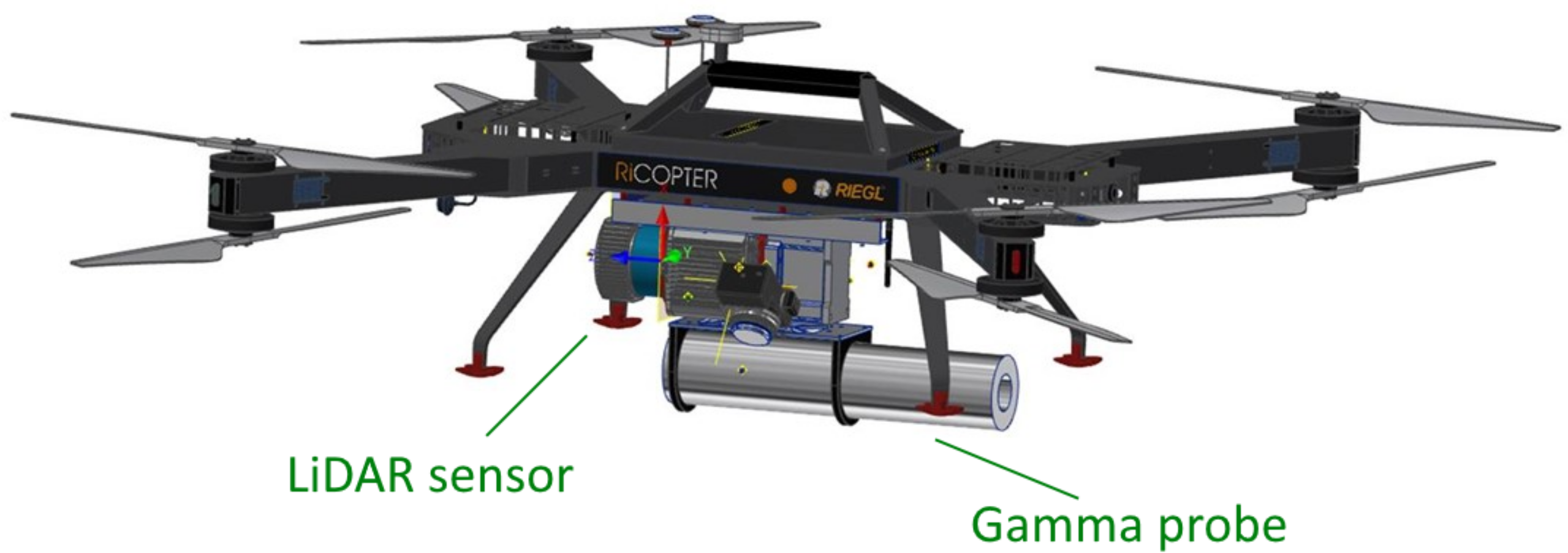
3.2.1. The Carrier Platform
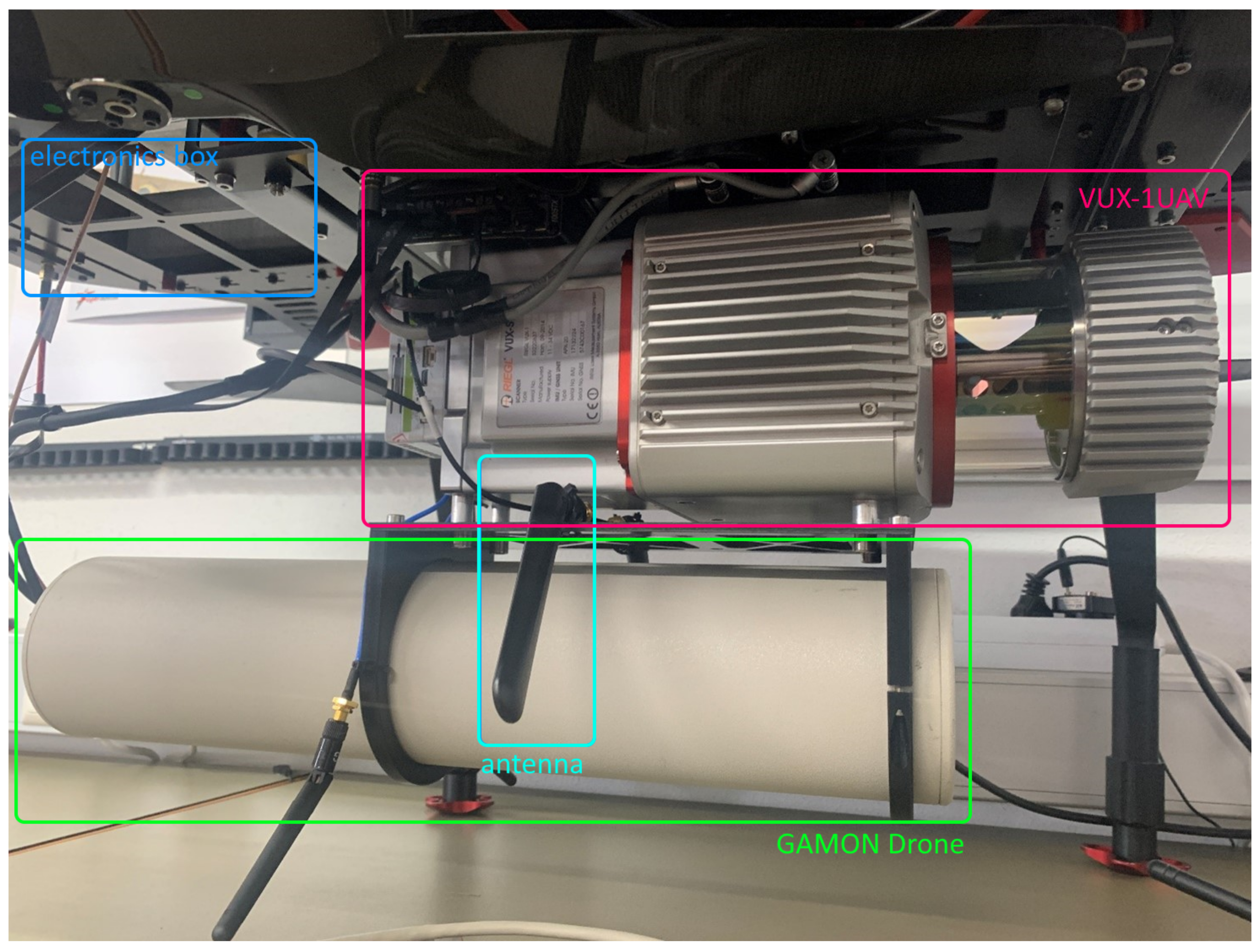
3.2.2. The Sensor Bundle
Positioning System
LiDAR Sensor
Gamma Sensor
3.2.3. Live Data Transmission
- PRR: 100–200 kHz;
- Line Divider: 2;
- Point Divider: 3.
3.3. Data Acquisition
3.3.1. LiDAR Pointcloud
3.3.2. Gamma Measurements
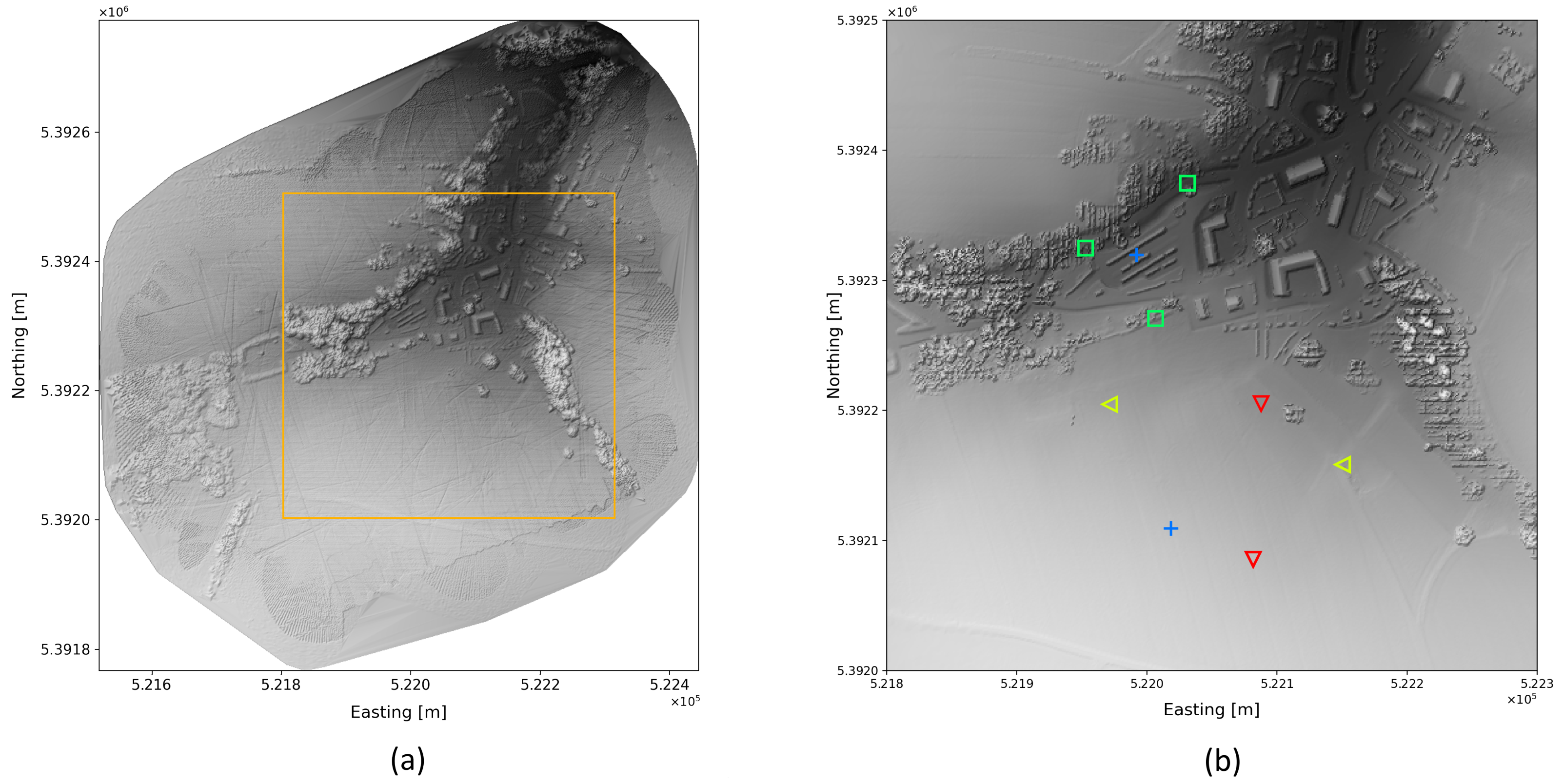
3.3.3. Radioactive Sources
- Two Co-60 sources;
- One Cs-137 source.
3.3.4. Test Flights
- Calibration is an ascend and descend flight without any source to collect background radiation data at various altitudes;
- Meander covers an area with a rectangular grid. This technique is very effective for recognizing radioactive sources on a large area;
- Highest dose rate is a technique used to pin point a source by iterative crossing the source location;
- Lane search technique is used to detect sources along a path on ground, e.g., road. If an increased radiation is detected, the copter flies a loop around it;
- Cloverleaf pattern is similar to highest dose rate technique used to pinpoint a source.
3.4. Methodology
3.4.1. Background Radiation Model
- Natural terrestrial background radiation;
- Cosmic background radiation;
- Radiation from construction materials, e.g., the carrier platform.
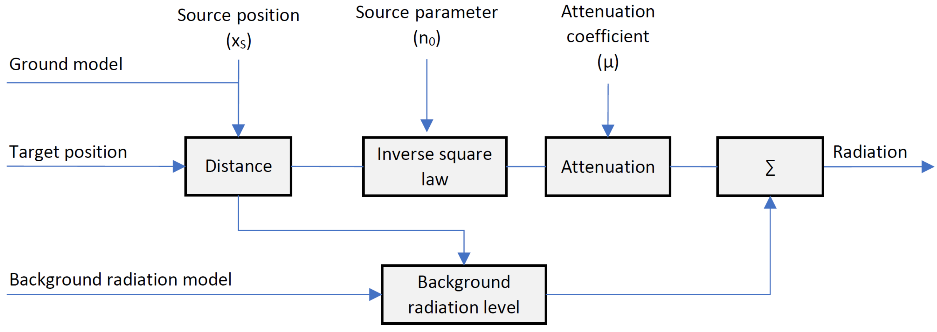
3.4.2. Radiation Model
3.4.3. Radioactive Source Localization
Localization Optimization Process
| Algorithm 1 Radiological source localization algorithm |
|
4. Results
4.1. Test Site
4.2. Gamma Reconstruction
4.3. Evaluation
4.3.1. Detection Performance
4.3.2. Localization Accuracy
4.4. Limitations
4.4.1. Detection Limit
4.4.2. Separation of Sources
5. Discussion
6. Conclusions
7. Patents
Author Contributions
Funding
Institutional Review Board Statement
Informed Consent Statement
Data Availability Statement
Conflicts of Interest
Abbreviations
| AMSL | Above mean sea level |
| Bq | Becquerel |
| CBRN | Chemical, biological, radiological and nuclear |
| Co-60 | Cobalt-60, radioactive isotope |
| CPS | Counts per second |
| Cs-137 | Caesium-137, radioactive isotope of caesium |
| EPSG | European Petroleum Survey Group Geodesy |
| GBq | Gigabecquerel, Bq |
| GIS | Geographic information system |
| PRR | Pulse repetition rate |
| RN | Radiological and nuclear |
| SNR | Signal-to-noise ratio |
| UAV | Unmanned aerial verhicle |
| UGV | Unmanned ground vehicle |
References
- Connor, D.; Martin, P.G.; Scott, T.B. Airborne radiation mapping: Overview and application of current and future aerial systems. Int. J. Remote Sens. 2016, 37, 5953–5987. [Google Scholar] [CrossRef]
- Lazna, T.; Gabrlik, P.; Jilek, T.; Zalud, L. Cooperation between an unmanned aerial vehicle and an unmanned ground vehicle in highly accurate localization of gamma radiation hotspots. Int. J. Adv. Robot. Syst. 2018, 15, 172988141775078. [Google Scholar] [CrossRef]
- Stibinger, P.; Baca, T.; Saska, M. Localization of Ionizing Radiation Sources by Cooperating Micro Aerial Vehicles With Pixel Detectors in Real-Time. IEEE Robot. Autom. Lett. 2020, 5, 3634–3641. [Google Scholar] [CrossRef]
- Pavlovsky, R.; Haefner, A.; Joshi, T.; Negut, V.; McManus, K.; Suzuki, E.; Barnowski, R.; Vetter, K. 3-D radiation mapping in real-time with the localization and mapping platform LAMP from unmanned aerial systems and man-portable configurations. arXiv 2018, arXiv:1901.05038. [Google Scholar]
- Gong, P.; Tang, X.B.; Huang, X.; Wang, P.; Wen, L.S.; Zhu, X.X.; Zhou, C. Locating lost radioactive sources using a UAV radiation monitoring system. Appl. Radiat. Isot. 2019, 150, 1–13. [Google Scholar] [CrossRef]
- Aleotti, J.; Micconi, G.; Caselli, S.; Benassi, G.; Zambelli, N.; Bettelli, M.; Zappettini, A. Detection of Nuclear Sources by UAV Teleoperation Using a Visuo-Haptic Augmented Reality Interface. Sensors 2017, 17, 2234. [Google Scholar] [CrossRef]
- Gabrlik, P.; Lazna, T.; Jilek, T.; Sladek, P.; Zalud, L. An automated heterogeneous robotic system for radiation surveys: Design and field testing. J. Field Robot. 2021, 38, 657–683. [Google Scholar] [CrossRef]
- Towler, J.; Krawiec, B.; Kochersberger, K. Radiation Mapping in Post-Disaster Environments Using an Autonomous Helicopter. Remote. Sens. 2012, 4, 1995–2015. [Google Scholar] [CrossRef]
- Categorization of Radioactive Sources; Number RS-G-1. 9 in General Safety Guides; International Atomic Energy Agency: Vienna, Austria, 2005. [Google Scholar]
- Marques, L.; Vale, A.; Vaz, P. State-of-the-Art Mobile Radiation Detection Systems for Different Scenarios. Sensors 2021, 21, 1051. [Google Scholar] [CrossRef]
- Pradeep Kumar, K.; Shanmugha Sundaram, G.; Thiruvengadathan, R. Advances in detection algorithms for radiation monitoring. J. Environ. Radioact. 2020, 217, 106216. [Google Scholar] [CrossRef]
- Grasty, R.L.; Minty, B.R.S. Guide to the Techncial Specifications for Airborne Gamma-Ray Surveys; Australian Geological Survey Organisation Canberra: Canberra, Australia, 1995; p. 89. [Google Scholar]
- Gunatilaka, A.; Ristic, B.; Gailis, R. On Localisation of a Radiological Point Source. In Proceedings of the 2007 Information, Decision and Control, Adelaide, Australia, 12–14 February 2007; IEEE: Piscataway, NJ, USA; pp. 236–241. [Google Scholar] [CrossRef]
- Wu, C.Q.; Berry, M.L.; Grieme, K.M.; Sen, S.; Rao, N.S.; Brooks, R.R.; Cordone, G. Network Detection of Radiation Sources Using Localization-Based Approaches. IEEE Trans. Ind. Inform. 2019, 15, 2308–2320. [Google Scholar] [CrossRef]
- Liu, A.H.; Bunn, J.J.; Chandy, K.M. An analysis of data fusion for radiation detection and localization. In Proceedings of the 2010 13th International Conference on Information Fusion, Edinburgh, UK, 26–29 July 2010; IEEE: Piscataway, NJ, USA, 2010; pp. 1–8. [Google Scholar] [CrossRef]
- Flanagan, R.; Brandt, L.; Osborne, A.; Deinert, M. Detecting Nuclear Materials in Urban Environments Using Mobile Sensor Networks. Sensors 2021, 21, 2196. [Google Scholar] [CrossRef]
- Nishizawa, Y.; Yoshida, M.; Sanada, Y.; Torii, T. Distribution of the 134 Cs/ 137 Cs ratio around the Fukushima Daiichi nuclear power plant using an unmanned helicopter radiation monitoring system. J. Nucl. Sci. Technol. 2016, 53, 468–474. [Google Scholar] [CrossRef]
- Bucher, B. Methodische Weiterentwicklungen in der Aeroradiometrie. Ph.D. Thesis, ETH Zurich, Zürich, Switzerland, 2001. [Google Scholar] [CrossRef]
- Minamoto, G.; Takeuchi, E.; Tadokoro, S. Estimation of ground surface radiation sources from dose map measured by moving dosimeter and 3D map. In Proceedings of the 2014 IEEE/RSJ International Conference on Intelligent Robots and Systems, Chicago, IL, USA, 14–18 September 2014; IEEE: Chicago, IL, USA, 2014; pp. 1889–1895. [Google Scholar] [CrossRef]
- Lazna, T. Optimizing the localization of gamma radiation point sources using a UGV. In Proceedings of the 2018 ELEKTRO, Mikulov, Czech Republic, 21–23 May 2018; IEEE: Piscataway, NJ, USA, 2018; pp. 1–6. [Google Scholar] [CrossRef]
- Gao, W.; Wang, W.; Zhu, H.; Huang, G.; Wu, D.; Du, Z. Robust Radiation Sources Localization Based on the Peak Suppressed Particle Filter for Mixed Multi-Modal Environments. Sensors 2018, 18, 3784. [Google Scholar] [CrossRef]
- Lee, M.S.; Shy, D.; Whittaker, W.R.; Michael, N. Active Range and Bearing-based Radiation Source Localization. In Proceedings of the 2018 IEEE/RSJ International Conference on Intelligent Robots and Systems (IROS), Madrid, Spain, 1–5 October 2018; IEEE: Piscataway, NJ, USA; pp. 1389–1394. [Google Scholar] [CrossRef]
- Mascarich, F.; Wilson, T.; Papachristos, C.; Alexis, K. Radiation Source Localization in GPS-Denied Environments Using Aerial Robots. In Proceedings of the 2018 IEEE International Conference on Robotics and Automation (ICRA), Brisbane, Australia, 21–25 May 2018; IEEE: Brisbane, Australia, 2018; pp. 6537–6544. [Google Scholar] [CrossRef]
- Newaz, A.A.R.; Jeong, S.; Lee, H.; Ryu, H.; Chong, N.Y.; Mason, M.T. Fast radiation mapping and multiple source localization using topographic contour map and incremental density estimation. In Proceedings of the 2016 IEEE International Conference on Robotics and Automation (ICRA), Stockholm, Sweden, 16–21 May 2021; Hosun, L., Ryu, H., Eds.; IEEE: Stockholm, Sweden, 2016; pp. 1515–1521. [Google Scholar] [CrossRef]
- Bandstra, M.S.; Hellfeld, D.; Vavrek, J.R.; Quiter, B.J.; Meehan, K.; Barton, P.J.; Cates, J.W.; Moran, A.; Negut, V.; Pavlovsky, R.; et al. Improved Gamma-Ray Point Source Quantification in Three Dimensions by Modeling Attenuation in the Scene. IEEE Trans. Nucl. Sci. 2021, 68, 2637–2646. [Google Scholar] [CrossRef]
- Krieger, H. Strahlenschutzbegriffe, Dosisgrößen und Dosisleistungskonstanten. In Grundlagen der Strahlungsphysik und des Strahlenschutzes; Vieweg Teubner Verlag: Wiesbaden, Germany, 2004; pp. 288–324. [Google Scholar] [CrossRef]
- Ahmed, S.N. Physics and Engineering of Radiation Detection, 1st ed.; Elsevier/Academic Press: Amsterdam, The Netherlands, 2007. [Google Scholar]
- Hubbell, J.H.; Seltzer, S.M. Tables of x-Ray Mass Attenuation Coefficients and Mass Energy-Absorption Coefficients 1 keV to 20 MeV for Elements Z = 1 to 92 and 48 Additional Substances of Dosimetry Interest; Technical Report NIST IR 5632; National Institute of Standards and Technology: Gaithersburg, MD, USA, 1995. [Google Scholar] [CrossRef]
- Lee, J.; Byun, J.; Yun, J.a. Mass attenuation coefficients of environmental samples for gamma-ray energies from 46.5 keV to 1408 keV. Int. J. Radiat. Res. 2020, 18, 201–207. [Google Scholar] [CrossRef]
- RiCOPTER-M. RiCOPTER-M. 2020. Available online: http://www.riegl.com/uploads/tx_pxpriegldownloads/RiCOPTER-M_sensor-platform_Infosheet_2020-09-21_print.pdf (accessed on 26 August 2022).
- TRIMBLE APPLANIX. APX-20 UAV High Performance GNSS-intertial Solution with Dual IMU’s. 2019. Available online: https://www.applanix.com/downloads/products/specs/APX20_UAV.pdf (accessed on 22 August 2022).
- RIEGL Laser Measurement Systems GmbH. RIEGL VUX-1UAV Data Sheet. 2021. Available online: http://www.riegl.com/uploads/tx_pxpriegldownloads/RIEGL_VUX-1UAV-22_Preliminary-Datasheet_2021-09-07.pdf (accessed on 22 August 2022).
- SkyHopper PRO, V. SkyHopper PRO V. 2019. Available online: https://www.skyhopper.biz/wp-content/uploads/2019/04/190317-DataSheet-SkyHopper-PROV-Gen-1.pdf (accessed on 26 August 2022).
- Pingel, T.J.; Clarke, K.C.; McBride, W.A. An improved simple morphological filter for the terrain classification of airborne LIDAR data. ISPRS J. Photogramm. Remote. Sens. 2013, 77, 21–30. [Google Scholar] [CrossRef]
- Knoll, G.F. Radiation Detection and Measurement, 3rd ed.; Wiley: New York, NY, USA; Weinheim, Germany, 2000. [Google Scholar]
- Mongus, D.; Lukač, N.; Žalik, B. Ground and building extraction from LiDAR data based on differential morphological profiles and locally fitted surfaces. ISPRS J. Photogramm. Remote. Sens. 2014, 93, 145–156. [Google Scholar] [CrossRef]
- Feng, C.C.; Guo, Z. Automating parameter learning for classifying terrestrial LiDAR point cloud using 2D land cover maps. Remote Sens. 2018, 10, 1192. [Google Scholar] [CrossRef]
- Landrieu, L.; Simonovsky, M. Large-scale point cloud semantic segmentation with superpoint graphs. In Proceedings of the IEEE Conference on Computer Vision and Pattern Recognition, Salt Lake City, UT, USA, 18–22 June 2018; pp. 4558–4567. [Google Scholar]
- Boulch, A. ConvPoint: Continuous convolutions for point cloud processing. Comput. Graph. 2020, 88, 24–34. [Google Scholar] [CrossRef]
- Boulch, A.; Guerry, J.; Le Saux, B.; Audebert, N. SnapNet: 3D point cloud semantic labeling with 2D deep segmentation networks. Comput. Graph. 2018, 71, 189–198. [Google Scholar] [CrossRef]
- Thomas, H.; Qi, C.R.; Deschaud, J.E.; Marcotegui, B.; Goulette, F.; Guibas, L.J. KPConv: Flexible and Deformable Convolution for Point Clouds. In Proceedings of the IEEE International Conference on Computer Vision, Seoul, Republic of Korea, 27 October–2 November 2019. [Google Scholar]

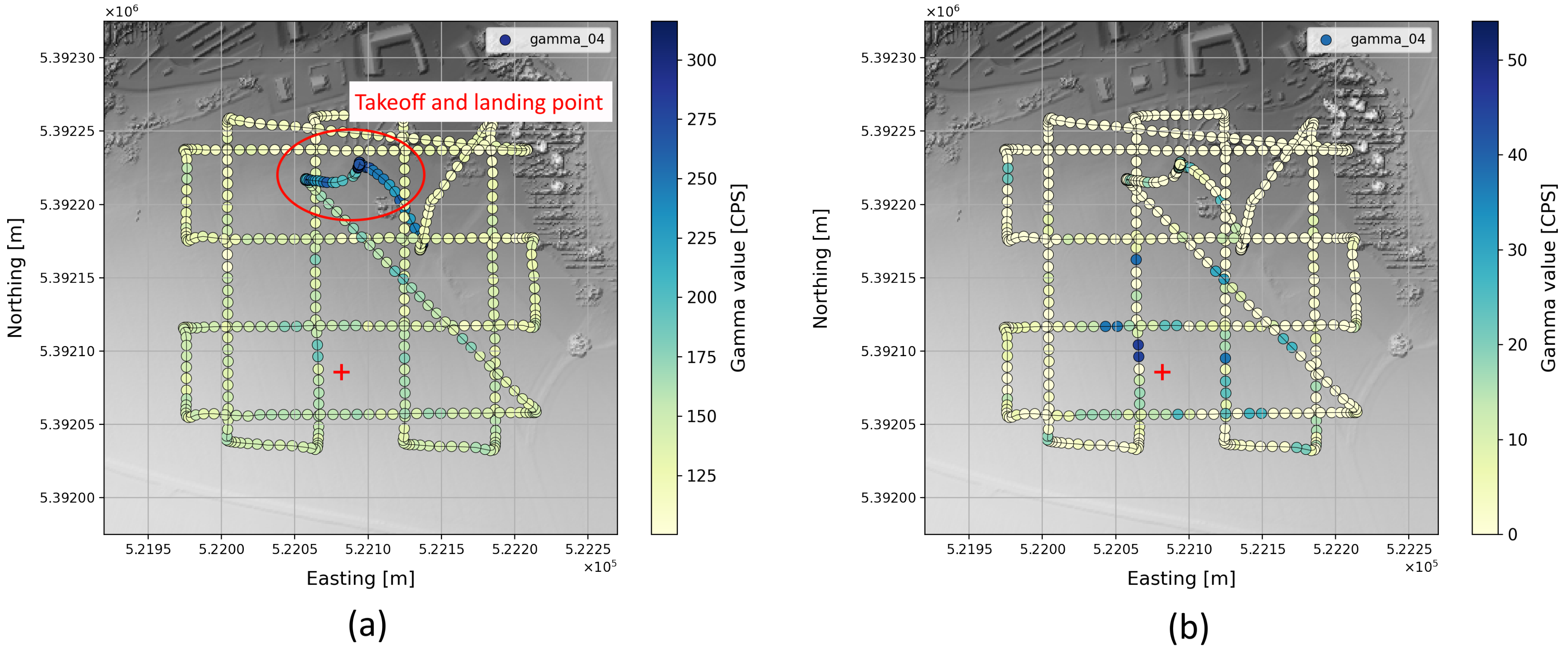
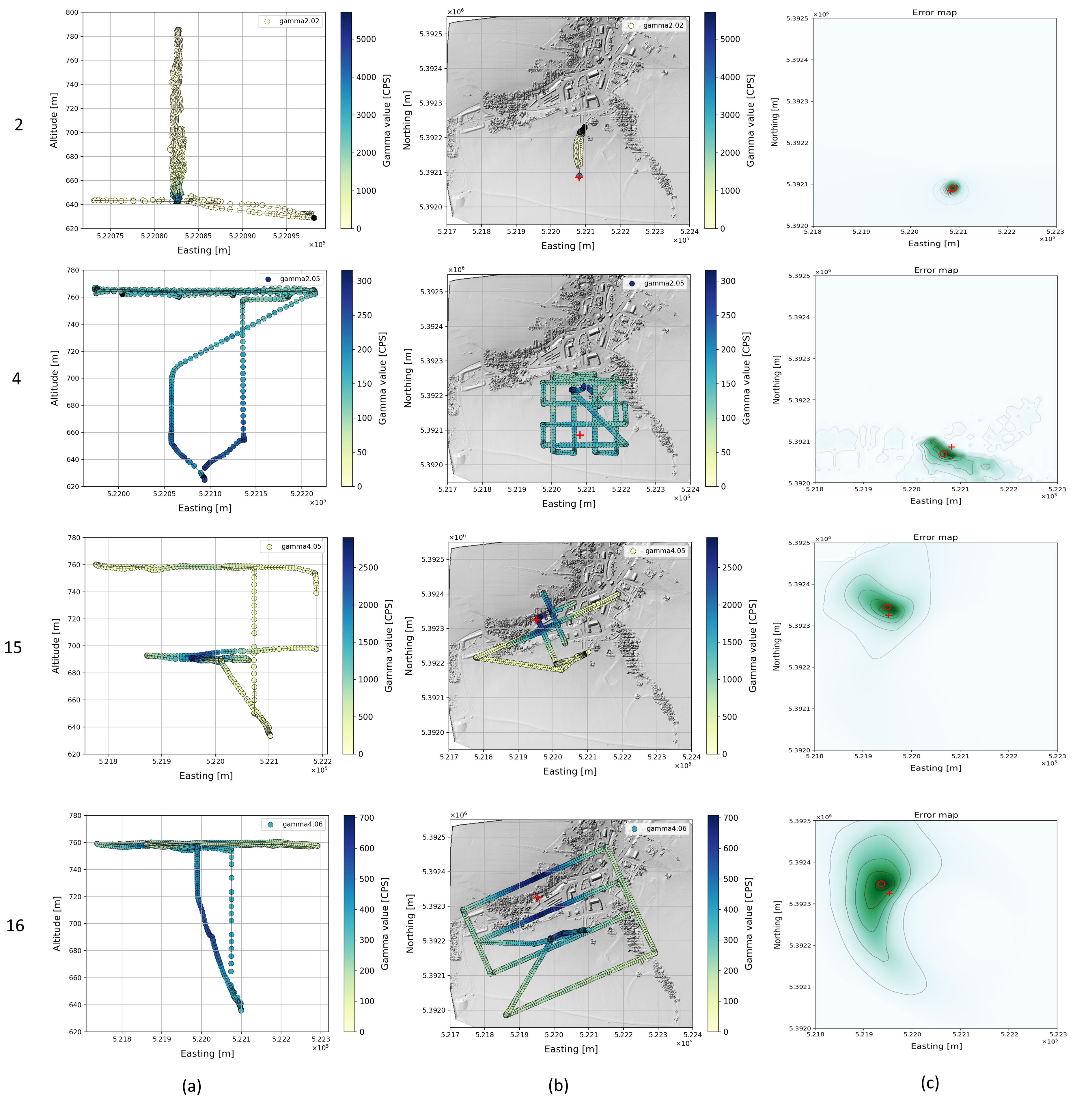

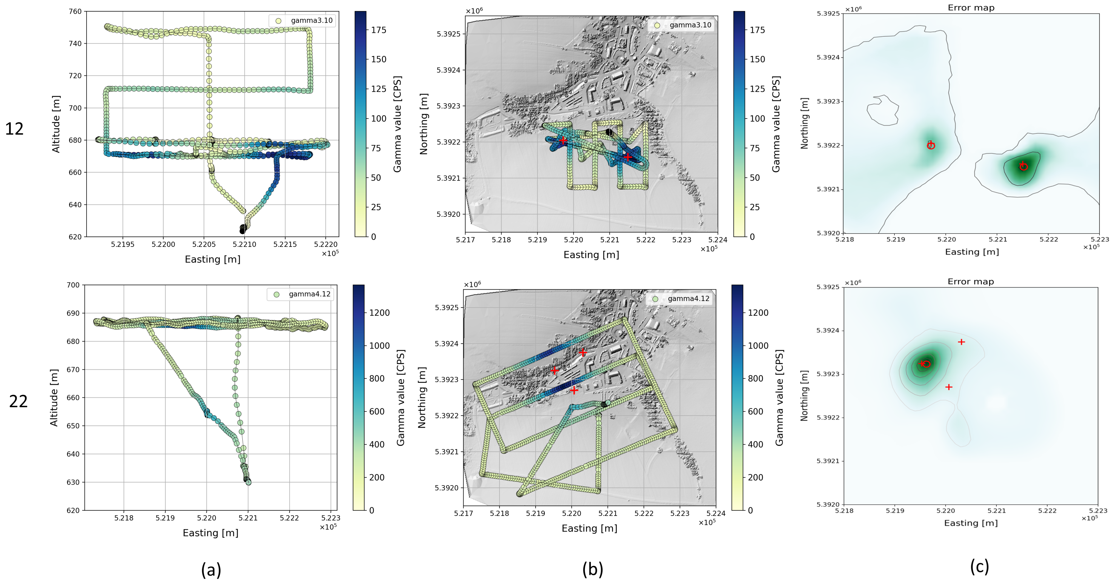
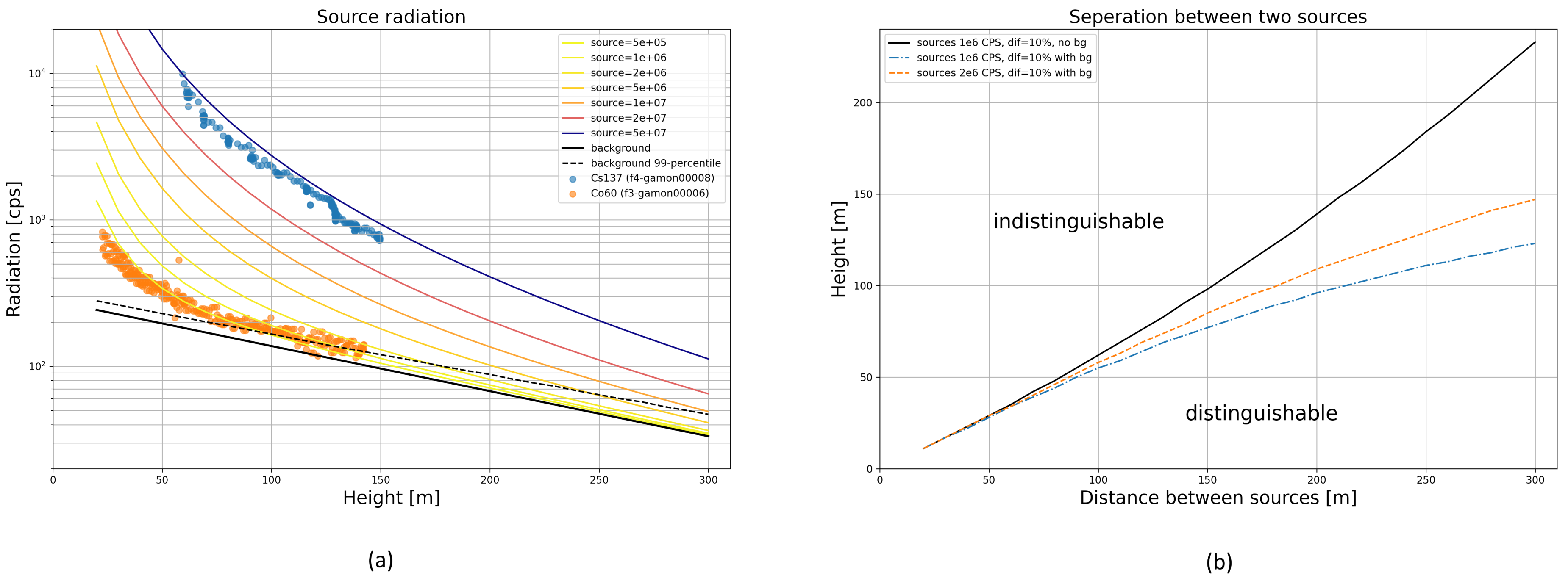
| No | Source(s) | Maneuver | Duration [s] |
|---|---|---|---|
| 1 | - | Calibration | 823 |
| 2 | Co-60 | Calibration | 573 |
| 3 | Co-60 | Meander | 680 |
| 4 | Co-60 | Meander | 539 |
| 5 | Co-60, Co-60 | Meander | 516 |
| 6 | - | Calibration | 792 |
| 7 | - | Calibration | 321 |
| 8 | Co-60 | Meander | 649 |
| 9 | Co-60 | Highest dose rate | 508 |
| 10 | Co-60 | Highest dose rate | 563 |
| 11 | Co-60 | Cloverleaf pattern | 486 |
| 12 | Co-60, Co-60 | Cloverleaf pattern | 756 |
| 13 | - | Calibration | 336 |
| 14 | Cs-137 | Lane search technique | 489 |
| 15 | Cs-137 | Lane search technique | 475 |
| 16 | Cs-137 | Lane search technique | 659 |
| 17 | Cs-137 | Meander | 699 |
| 18 | Cs-137 | Cloverleaf pattern | 714 |
| 19 | Cs-137, Co-60 | Lane search technique | 556 |
| 20 | Cs-137, Co-60 | Lane search technique | 658 |
| 21 | Cs-137, Co-60 | Cloverleaf pattern | 585 |
| 22 | Cs-137, Co-60, Co-60 | Lane search technique | 685 |
| 23 | - | Calibration | 2939 |
| 24 | Co-60 | Lane search technique | 865 |
| 25 | Co-60 | Meander | 538 |
| 26 | Co-60, Co-60 | Meander | 699 |
| 27 | Co-60, Co-60 | Lane search technique | 421 |
| 28 | Co-60, Co-60 | Highest dose rate | 475 |
| Used in Flight(s) no. | Source | Latitude | Longitude | Distance to First Source [m] |
|---|---|---|---|---|
| 2–5 | Co-60 | 48.68250 | 15.30008 | - |
| 5 | Co-60 | 48.68142 | 15.29999 | 120 |
| 8–12 | Co-60 | 48.68210 | 15.30090 | - |
| 12 | Co-60 | 48.68250 | 15.29850 | 182 |
| 14–22 | Cs-137 | 48.68358 | 15.29826 | - |
| 19–22 | Co-60 | 48.68403 | 15.29932 | 93 |
| 22 | Co-60 | 48.68309 | 15.29898 | 76 |
| 24–28 | Co-60 | 48.68353 | 15.29879 | - |
| 26–28 | Co-60 | 48.68164 | 15.29914 | 212 |
| No | Max Flight Height [m] | Number of Sources | Distance 1st Source [m] | Distance 2nd Source [m] | Distance 3rd Source [m] |
|---|---|---|---|---|---|
| 1 | 153 | 0 | - | - | - |
| 2 | 153 | 1 | 8.3 | - | - |
| 3 | 141 | 1 | 27.7 | - | - |
| 4 | 148 | 1 | 20 | - | - |
| 5 | 118 | 2 | 64.4 | 72.1 | - |
| 6 | 133 | 0 | - | - | - |
| 7 | 109 | 0 | - | - | - |
| 8 | 135 | 1 | 34.7 | - | - |
| 9 | 98 | 1 | 14.4 | - | - |
| 10 | 91 | 1 | 10.4 | - | - |
| 11 | 99 | 1 | 23.7 | - | - |
| 12 | 124 | 2 | 4.4 | 3.4 | - |
| 13 | 134 | 0 | - | - | - |
| 14 | 143 | 1 | 15.7 | - | - |
| 15 | 146 | 1 | 15.1 | - | - |
| 16 | 150 | 1 | 18.2 | - | - |
| 17 | 144 | 1 | 33.3 | - | - |
| 18 | 144 | 1 | 21.6 | - | - |
| 19 | 112 | 2 | 15.1 | not detected | - |
| 20 | 115 | 2 | 7.9 | not detected | - |
| 21 | 110 | 2 | 16 | not detected | - |
| 22 | 77 | 3 | 17.6 | not detected | not detected |
| 23 | 130 | 0 | - | - | - |
| 24 | 108 | 1 | 31.1 | - | - |
| 25 | 97 | 1 | 8.6 | - | - |
| 26 | 79 | 2 | 10.8 | 33.4 | - |
| 27 | 71 | 2 | 13.5 | 20.2 | - |
| 28 | 65 | 2 | 9.1 | 11.3 | - |
Publisher’s Note: MDPI stays neutral with regard to jurisdictional claims in published maps and institutional affiliations. |
© 2022 by the authors. Licensee MDPI, Basel, Switzerland. This article is an open access article distributed under the terms and conditions of the Creative Commons Attribution (CC BY) license (https://creativecommons.org/licenses/by/4.0/).
Share and Cite
Schraml, S.; Hubner, M.; Taupe, P.; Hofstätter, M.; Amon, P.; Rothbacher, D. Real-Time Gamma Radioactive Source Localization by Data Fusion of 3D-LiDAR Terrain Scan and Radiation Data from Semi-Autonomous UAV Flights. Sensors 2022, 22, 9198. https://doi.org/10.3390/s22239198
Schraml S, Hubner M, Taupe P, Hofstätter M, Amon P, Rothbacher D. Real-Time Gamma Radioactive Source Localization by Data Fusion of 3D-LiDAR Terrain Scan and Radiation Data from Semi-Autonomous UAV Flights. Sensors. 2022; 22(23):9198. https://doi.org/10.3390/s22239198
Chicago/Turabian StyleSchraml, Stephan, Michael Hubner, Philip Taupe, Michael Hofstätter, Philipp Amon, and Dieter Rothbacher. 2022. "Real-Time Gamma Radioactive Source Localization by Data Fusion of 3D-LiDAR Terrain Scan and Radiation Data from Semi-Autonomous UAV Flights" Sensors 22, no. 23: 9198. https://doi.org/10.3390/s22239198
APA StyleSchraml, S., Hubner, M., Taupe, P., Hofstätter, M., Amon, P., & Rothbacher, D. (2022). Real-Time Gamma Radioactive Source Localization by Data Fusion of 3D-LiDAR Terrain Scan and Radiation Data from Semi-Autonomous UAV Flights. Sensors, 22(23), 9198. https://doi.org/10.3390/s22239198


