Instability Monitoring and Numerical Analysis of Typical Coal Mines in Southwest China Based on DS-InSAR
Abstract
1. Introduction
2. Materials and Methods
2.1. Overview of the Interested Area
2.2. Sentinel Data and Processing in the Research Area
2.3. Methods
3. Results
3.1. Analysis of DS-InSAR Results
3.2. Time Series DS-InSAR Results and Correlation Analysis
4. Discussion
4.1. Mountain Stability Numerical Analysis Based on DS-InSAR
4.2. Analysis of Mountain Instability Mechanism in Mining Area
4.3. DS-InSAR and Numerical Simulation
5. Conclusions
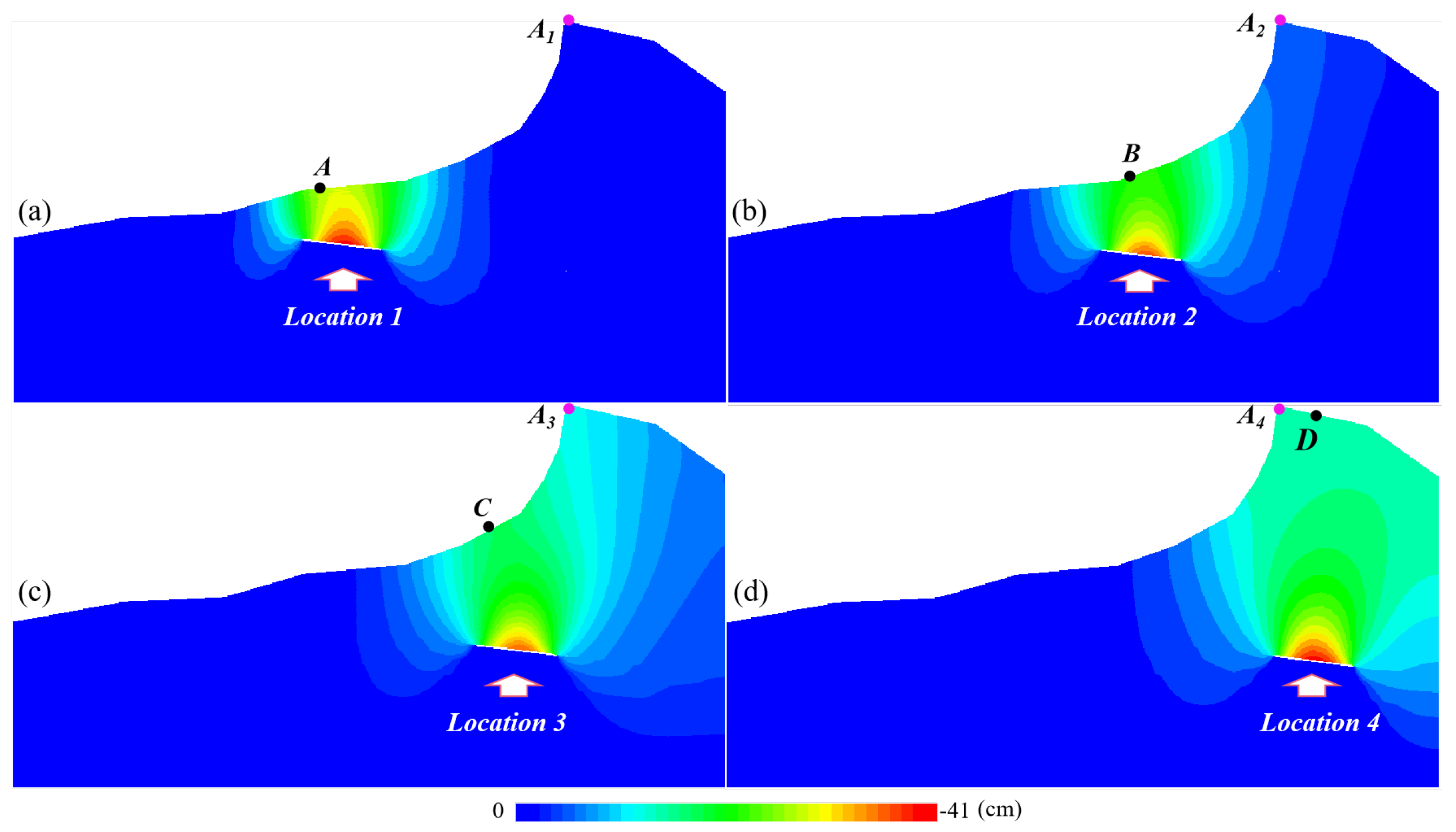
- The results of the DS-InSAR experiment show that coal mining influences mountain stability. There is a certain rule that the influence of mining activities on the mountain is positively correlated with time and negatively correlated with the distance between the mining face and the mountaintop.
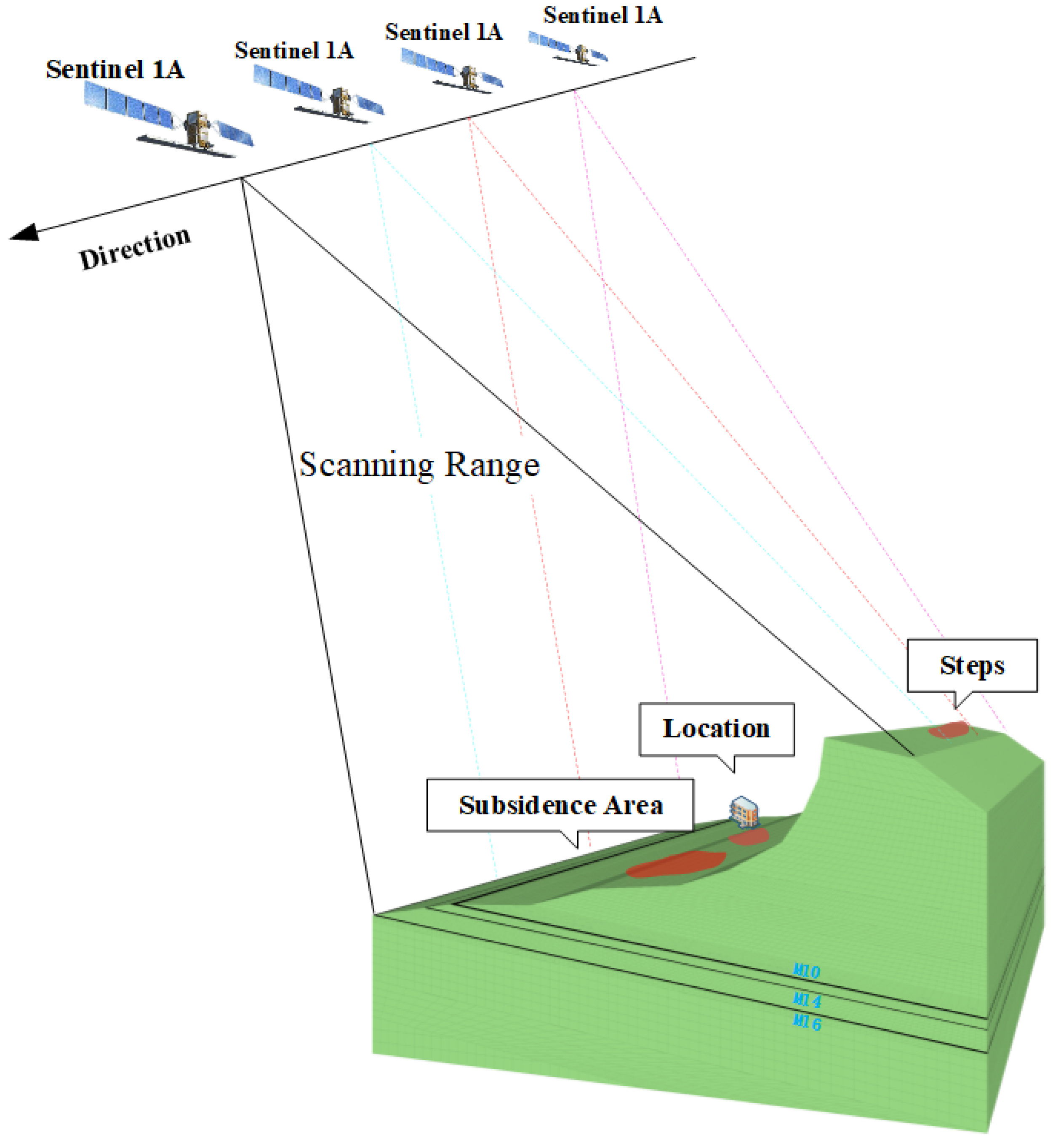
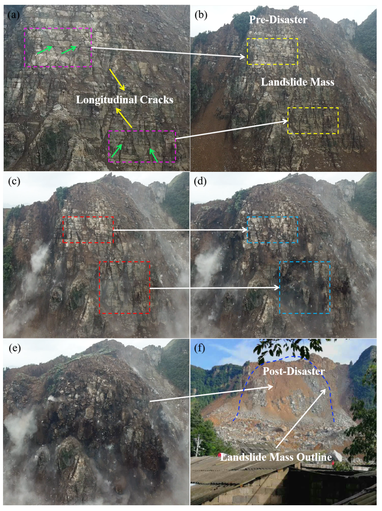
- Combining the experimental results of DS-InSAR with the numerical simulation results can effectively explain the ground movement causes at the top and bottom of the mountain in the study area. Figure 7 shows the steps on the trailing edge of the mountaintop. This was caused by the downward displacement of the trailing edge of the mountaintop due to mining activities.
- According to the results of DS-InSAR and numerical simulation, the mining activities destroyed the mountain and reduced its stability. Therefore, we conclude that coal mining is one of the causes of mountain collapse.
- The experimental results show that the DCB collapses are determined by four parameters. Among these four relationships, the parameter K is significant in determining the relationship between and .
Author Contributions
Funding
Institutional Review Board Statement
Informed Consent Statement
Data Availability Statement
Acknowledgments
Conflicts of Interest
References
- Yao, J.; Yao, X.; Wu, Z.; Liu, X. Research on surface deformation of ordos coal mining area by integrating multitemporal D-InSAR and offset tracking technology. Sens. J. 2021, 4, 1–14. [Google Scholar] [CrossRef]
- Oh, H.J.; Lee, S. Shallow landslide susceptibility modeling using the data mining models artificial neural network and boosted tree. Appl. Sci. 2017, 10, 1000. [Google Scholar] [CrossRef]
- Ma, J.; Tang, H.; Hu, X.; Bobet, A.; Zhang, M.; Zhu, T.; Song, Y.J.; Ez Eldin, M.A. Identification of causal factors for the Majiagou landslide using modern data mining methods. Landslides 2017, 1, 311–322. [Google Scholar] [CrossRef]
- Zhu, J.J.; Yang, Z.F.; Li, Z.W. Recent progress in retrieving and predicting mining-induced 3D displace-ments using InSAR. Acta Geod. Cartogr. Sin. 2019, 2, 135. [Google Scholar] [CrossRef]
- Zhao, J.J.; Li, J.S.; Ma, Y.T. Experimental study on failure process of mining landslide induced by rainfall. J. Coal. Chin. Sci. 2020, 2, 760–769. [Google Scholar]
- Zhao, J.J.; Ma, Y.T.; Lin, B. Geomechanical mode of mining landslides with gently counter-inclined bedding-a case study of Madaling landslide in Guizhou Province. Chin. J. Rock Mech. Eng. 2016, 11, 2217–2224. [Google Scholar]
- Wang, Y.C. Deformation Failure Mechanism and Stability Research of Massif above the Mined out Area in Gently Inclined Coal Beds. Master’s Thesis, Chengdu University of Technology, Chengdu Sichuan China, Chengdu, China, 2013. [Google Scholar]
- Shan, X.Y.; Jiang, Y.D.; Wang, L.J.; Zhao, Y.X.; Hong, Y.Q. Finite element analysis of effect of underground coal mining on landslide of the Wei Mountain. J. Coal. Chin. Sci. Soc. 2008, 1, 23–27. [Google Scholar]
- Dong, J.; Li, H.; Wang, Y.; Zhang, Y. Characteristics and monitoring-based analysis on deformation mechanism of Jianshanying landslide, Guizhou Province, southwestern China. Arabian J. Geosci. 2021, 3, 1–10. [Google Scholar] [CrossRef]
- Yu, X.Y.; Mao, X.W. A preliminary discrimination model of a deep mining landslide and its application in the Guanwen coal mine. Bull. Eng. Geol. Environ. 2020, 1, 485–493. [Google Scholar]
- Liao, M.S.; Dong, J.; Li, M.H.; Ao, M.; Zhang, L.; Shi, X.G. Radar remote sensing for potential landslides detection and deformation monitoring. Nat. Remote Sens. Bull. 2021, 1, 332–341. [Google Scholar]
- Li, X.E.; Zhou, L. Application of InSAR technology in landslide hazard: Progress and prospects. Nat. Remote Sens. Bull. 2021, 2, 614–629. [Google Scholar]
- Wang, L.Y.; Deng, K.Z.; Zheng, M.N. Research on ground deformation monitoring method in mining areas using the probability integral model fusion D-InSAR sub-band InSAR and offset-tracking. Int. J. Appl. Earth Obs. Geoinf. 2020, 1, 101–116. [Google Scholar] [CrossRef]
- Wang, L.; Teng, C.Q.; Jiang, K.G.; Jiang, C.; Zhu, S. D-InSAR Monitoring Method of Mining Subsidence Based on Boltzmann and Its Application in Building Mining Damage Assessment. KSCE J. Civ. Eng. 2022, 1, 353–370. [Google Scholar] [CrossRef]
- Zhang, Z.L.; Zeng, Q.; Jian, J. Application of D-InSAR Technology on Risk Assessment of Mining Area. In Proceedings of the IGARSS 2019-2019 IEEE International Geoscience and Remote Sensing Symposium, Yokohama, Japan, 28 July–2 August 2019; Volume 8, pp. 9695–9698. [Google Scholar]
- Wang, L.; Jiang, C.; Zhang, X.; Li, N.; Zha, J. Monitoring method of surface subsidence induced by inclined coal seam mining based on single line of sight D-InSAR. Geomat. Inf. Sci. Wuhan Univ. 2019, 6, 814–820. [Google Scholar]
- Fan, H.D.; Wei, G.; Yong, Q.; Xue, J.Q.; Chen, B.Q. A model for extracting large deformation mining subsidence using D-InSAR technique and probability integral method. Trans. Nonferrous Met. Soc. China 2014, 4, 1242–1247. [Google Scholar] [CrossRef]
- Yan, Y.G.; Dai, H.Y.; Ge, L.L.; Guo, J.T.; Ng, A.H.M.; Li, X.J. Numerical simulation of dynamic surface deformation based on DInSAR monitoring. Trans. Nonferrous Met. Soc. China 2014, 4, 1248–1254. [Google Scholar] [CrossRef]
- Jiang, M.; Ding, X.L.; He, X.F.; Li, Z.W.; Shi, G.Q. FaSHPS-InSAR technique for distributed scatterers: A case study over the lost hills oil field, California. Chin. J. Geophys. 2016, 10, 3592–3603. [Google Scholar]
- Graniczny, M.; Colombo, D.; Kowalski, Z.; Przyłucka, M.; Zdanowski, A. New results on ground deformation in the Upper Silesian Coal Basin (southern Poland) obtained during the DORIS Project (EU-FP 7). Pure Appl. Geophys. 2015, 11, 3029–3042. [Google Scholar] [CrossRef]
- Du, Z.Y.; Ge, L.L.; Ng, A.H.M.; Li, X. An innovative distributed scatterer based time-series InSAR method over underground mining region. In Proceedings of the 2017 IEEE International Geoscience and Remote Sensing Symposium (IGARSS), Fort Worth, TX, USA, 23–28 July 2017; Volume 7, pp. 4610–4613. [Google Scholar]
- Hu, S.; Wu, W.H.; Long, S.C.; Zhang, T.X. Application of Distributed Scatterer in Deformation Monitoring of Hongqinghe Coal Mine. J. Geod. Geodyn. 2019, 12, 1261–1264. [Google Scholar]
- Li, T.; Zhang, H.; Fan, H.; Zheng, C.; Liu, J. Position inversion of goafs in deep coal seams based on DS-InSAR data and the probability integral methods. Remote Sens. 2021, 7, 2898. [Google Scholar] [CrossRef]
- Deng, J.; Lu, L. Surface Subsidence Monitoring in Mining Area Based on SBAS Method Fusing Distributed Scatterers. Earth Environ. Sci. Trans. 2020, 3, 205–211. [Google Scholar] [CrossRef]
- Li, Y.; Jiang, J.X.; Du, Y.L. Surface subsidence monitoring by time series InSAR integrating with distributed targets in mining region. J. Chin. Uni. Min. Technol. 2020, 11, 1199–1206. [Google Scholar]
- Wu, W.H.; Zhang, Z.W.; Li, T.; Long, S.C. A study of sentinel-1 TOPS mode co-registration. Acta Geod. Cartogr. Sin. 2017, 9, 1156–1164. [Google Scholar]
- Wu, W.H.; Zhang, L.; Zhang, T.X.; Wang, M.Z.; Long, S.C.; Duan, M.; Zhou, Z.W.; Zhu, C.G. Advanced ESD coregistration of inteferometric processing for Sentinel-1 TOPS data. Acta Geod. Cartogr. Sin. 2020, 11, 1451–1462. [Google Scholar]
- Ma, Z.F.; Jiang, M.; Ding, Q.X. Times-series co-registretion for Srntinel-1 TOPS SAR Data. Acta Geodactica Cartogr. Sin. 2021, 5, 634–640. [Google Scholar]
- Li, Z.; Song, C.; Yu, C.; Xiao, R.; Chen, L.; Luo, H.; Zhang, Q. Application of Satellite Radar Remote Sensing to Landslide Detection and Monitoring: Challenges and Solutions. J. Wuhan. Uni. (Inf. Sci. Ed.) 2004, 1, 72–76. [Google Scholar]
- Ferretti, A.; Fumagalli, A.; Novali, F.; Prati, C.; Rocca, F.; Rucci, A. A New Algorithm for Processing Interferometric Data-Stacks: SqueeSAR. IEEE Trans. Geosci. Remote. Sens. 2011, 2, 3460–3470. [Google Scholar] [CrossRef]
- Jiang, M.; Ding, X.L.; Li, Z.W. Research on Homogeneous Sample Selection Algorithm of Time Series InSAR. J. Geophys. 2018, 12, 4767–4776. [Google Scholar]
- Jiang, M.; Guarnieri, A.M. Distributed scatterer interferometry with the refinement of spatiotemporal coherence. IEEE Trans. Geosci. Remote Sens. 2020, 6, 3977–3987. [Google Scholar] [CrossRef]
- Fan, R.Y.; Jiao, J.; Gao, S.; Zeng, Q.M. Comparison research of high coherent target selection based on InSAR time series analysis. J. Geo-inf. Sci. 2016, 6, 805–814. [Google Scholar]
- Sun, Y.; Li, D.; Miao, F.; She, X.; Yang, S.; Xie, X. Effects of Weak Bedding Plane, Fault, and Extreme Rainfall on the Landslide Event of a High Cut-Slope. Sensors 2022, 9, 6790. [Google Scholar] [CrossRef] [PubMed]





| Location | M14,M16 Area | M14,M16 Area | 11,008Working Face | 11,010Working Face | 11,013Working Face |
|---|---|---|---|---|---|
| Time | 2015-01∼2015-09 | 2015-10∼2016-07 | 2016-08∼2016-10 | 2016-12∼2017-02 | 2017-03∼2017-08 |
| Closer | 365 m | 171 m | 94 m | 53 m | 75 m |
| Farther | 578 m | 387 m | 279 m | 155 m | 334 m |
| Order | Stage1 | Stage2 | Stage3 | Stage4 | Stage5 |
Publisher’s Note: MDPI stays neutral with regard to jurisdictional claims in published maps and institutional affiliations. |
© 2022 by the authors. Licensee MDPI, Basel, Switzerland. This article is an open access article distributed under the terms and conditions of the Creative Commons Attribution (CC BY) license (https://creativecommons.org/licenses/by/4.0/).
Share and Cite
Liu, M.; Long, S.; Wu, W.; Liu, P.; Zhang, L.; Zhu, C. Instability Monitoring and Numerical Analysis of Typical Coal Mines in Southwest China Based on DS-InSAR. Sensors 2022, 22, 7811. https://doi.org/10.3390/s22207811
Liu M, Long S, Wu W, Liu P, Zhang L, Zhu C. Instability Monitoring and Numerical Analysis of Typical Coal Mines in Southwest China Based on DS-InSAR. Sensors. 2022; 22(20):7811. https://doi.org/10.3390/s22207811
Chicago/Turabian StyleLiu, Maoqi, Sichun Long, Wenhao Wu, Ping Liu, Liya Zhang, and Chuanguang Zhu. 2022. "Instability Monitoring and Numerical Analysis of Typical Coal Mines in Southwest China Based on DS-InSAR" Sensors 22, no. 20: 7811. https://doi.org/10.3390/s22207811
APA StyleLiu, M., Long, S., Wu, W., Liu, P., Zhang, L., & Zhu, C. (2022). Instability Monitoring and Numerical Analysis of Typical Coal Mines in Southwest China Based on DS-InSAR. Sensors, 22(20), 7811. https://doi.org/10.3390/s22207811


