
Data Collection in an IoT Off-Grid Environment Systematic Mapping of Literature


Abstract
:1. Introduction
1.1. SLM Research Objectives and Questions
- RQ1—What algorithm is used in routing for data collection?
- RQ2—What technology is used for the reception of data by the drone?
- RQ3—What network simulator software was used in the study?
1.2. Article Organization
2. Planning
2.1. Search String and Research Sources
STRING: IoT AND (UAV OR drones) AND "data collection"
2.2. Inclusion and Exclusion Criteria
- IC1—Studies that focus on collecting data generated in IoT with drone collection.
- IC2—Papers with drone routing for data collection.
- IC3—Relevant articles in the last years.
- IC4—Works using network simulator.
- EC1—Studies not associated with the research questions.
- EC2—Duplicate articles where the same topic was being evaluated.
3. Execution
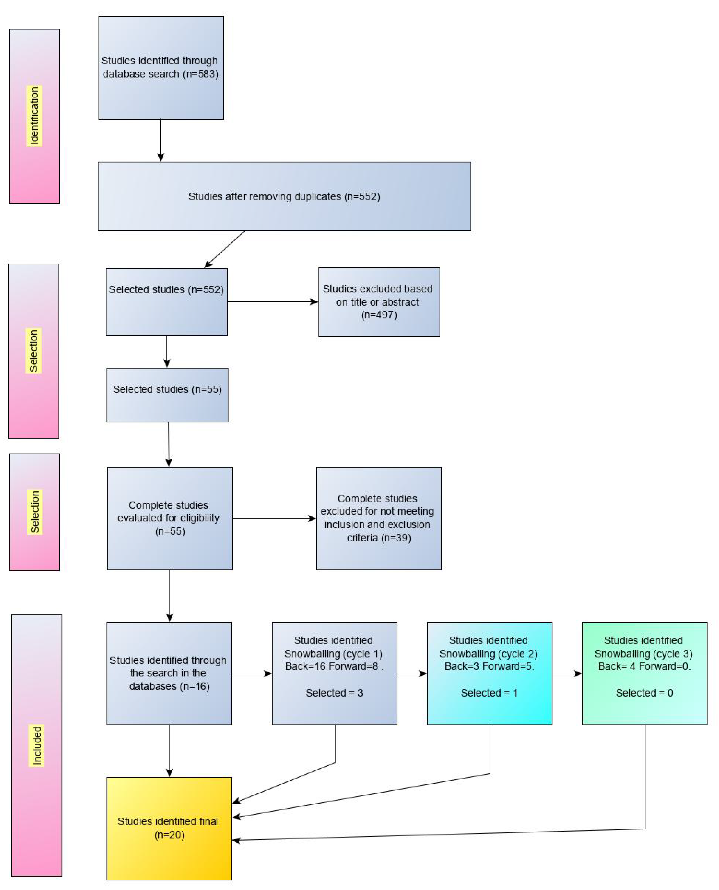
Selection Procedure
4. Requirements Results
- RQ1—What algorithm is used in routing for data collection?
- RQ2—What technology is used for the reception of data by the drone?
- RQ3—What network simulator software was used in the study?
4.1. RQ1—Algorithm Used in Routing
4.2. RQ2—Technology Employed to Receive Data
4.3. RQ3—Network Simulator Software
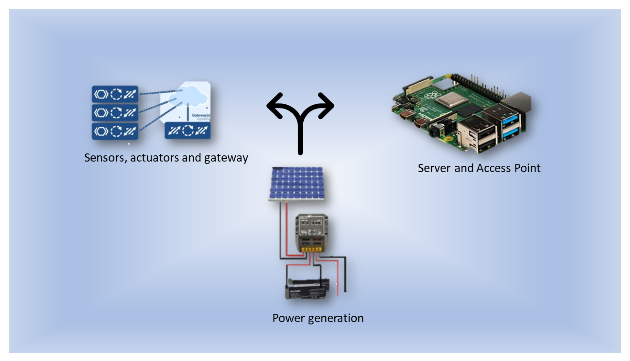
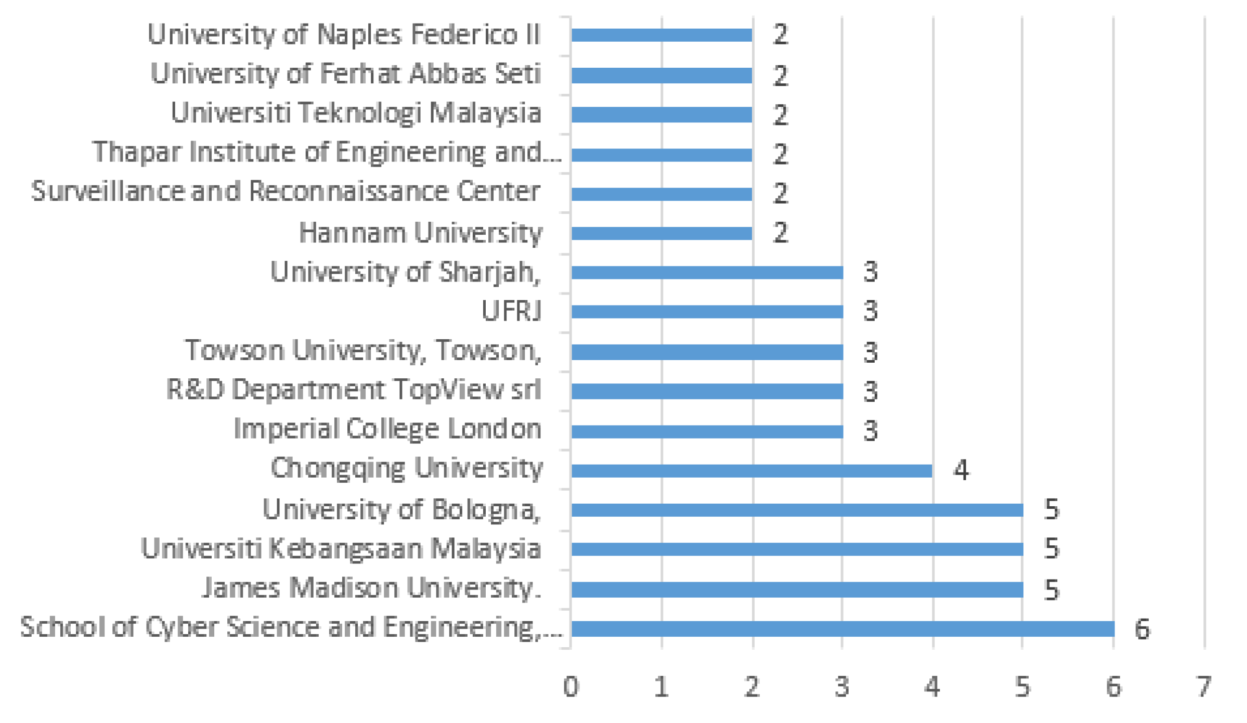
5. Work Description
6. Conclusions
- Algorithm to determine the best path for the drone to go to the points.
- Type of communication between the drone and the server containing the data.
- Network simulator.
Author Contributions
Funding
Conflicts of Interest
References
- Keele, S. Guidelines for Performing Systematic Literature Reviews in Software Engineering; Technical report, ver. 2.3 EBSE technical report; EBSE: Durham, UK, 2007. [Google Scholar]
- Alam, K.; Ahmad, R.; Akhunzada, A.; Nasir, M.; Khan, S. Impact analysis and change propagation in service-oriented enterprises: A systematic review. Inf. Syst. 2015, 54, 43–73. [Google Scholar] [CrossRef]
- Ouhbi, S.; Idri, A.; Fernández-Alemán, J.; Toval, A. Requirements engineering education: A systematic mapping study. Requir. Eng. 2015, 20, 119–138. [Google Scholar] [CrossRef]
- Wohlin, C. Guidelines for snowballing in systematic literature studies and a replication in software engineering. In Proceedings of the 18th International Conference on Evaluation And Assessment In Software Engineering—EASE ’14, London, UK, 13–14 May 2014; pp. 1–10. Available online: http://dl.acm.org/citation.cfm?doid=2601248.2601268 (accessed on 10 June 2021).
- Gagliarde, G.; Iadaresta, M.; Mennella, A.; Bonanomi, G.; Idbella, M. A new system for agrometereological data collection in areas lacking communication networks. In Proceedings of the 2019 IEEE International Workshop on Metrology for Agriculture and Forestry (MetroAgriFor), Portici, Italy, 24–26 October 2019; pp. 217–221. [Google Scholar]
- Wang, Z.; Tao, J.; Gao, Y.; Xu, Y.; Sun, W.; Li, X. A precision adjustable trajectory planning scheme for UAV-based data collection in IoTs. Peer-to-Peer Netw. Appl. 2021, 14, 655–671. [Google Scholar] [CrossRef]
- Cao, H.; Yao, H.; Cheng, H.; Lian, S. A solution for data collection of large-scale outdoor internet of things based on UAV and dynamic clustering. In Proceedings of the 2020 IEEE 9th Joint International Information Technology and Artificial Intelligence Conference (ITAIC), Chongqing, China, 11–13 December 2020; Volume 9, pp. 2133–2136. [Google Scholar]
- Yang, X.; Fu, S.; Wu, B.; Zhang, M. A survey of key issues in UAV data collection in the Internet of Things. In Proceedings of the 2020 IEEE Intl Conf on Dependable, Autonomic and Secure Computing, Intl Conf on Pervasive Intelligence And Computing, Intl Conf on Cloud and Big Data Computing, Intl Conf on Cyber Science and Technology Congress (DASC/PiCom/CBDCom/CyberSciTech), Calgary, AB, Canada, 17–22 August 2020; pp. 410–413. [Google Scholar]
- Trotta, A.; Felice, M.; Perilli, L.; Scarselli, E.; Cinotti, T. BEE-DRONES: Ultra low-power monitoring systems based on unmanned aerial vehicles and wake-up radio ground sensors. Comput. Netw. 2020, 180, 107425. [Google Scholar] [CrossRef]
- Goudarzi, S.; Kama, N.; Anisi, M.; Zeadally, S.; Mumtaz, S. Data collection using unmanned aerial vehicles for Internet of Things platforms. Comput. Electr. Eng. 2019, 75, 1–15. [Google Scholar] [CrossRef]
- Zhang, M.; Li, X. drone-enabled Internet-of-Things relay for environmental monitoring in remote areas without public networks. IEEE Internet Things J. 2020, 7, 7648–7662. [Google Scholar] [CrossRef]
- Min, H.; Jung, J.; Kim, B.; Hong, J.; Heo, J. Dynamic Rendezvous Node Estimation for Reliable Data Collection of a drone as a Mobile IoT Gateway. IEEE Access 2019, 7, 184285–184293. [Google Scholar] [CrossRef]
- Qin, Y.; Boyle, D.; Yeatman, E. Efficient and reliable aerial communication with wireless sensors. IEEE Internet Things J. 2019, 6, 9000–9011. [Google Scholar] [CrossRef] [Green Version]
- Safia, A.; Al Aghbari, Z.; Kamel, I. Efficient data collection by mobile sink to detect phenomena in internet of things. Information 2017, 8, 123. [Google Scholar] [CrossRef] [Green Version]
- Potter, B.; Valentino, G.; Yates, L.; Benzing, T.; Salman, A. Environmental Monitoring Using a drone-Enabled Wireless Sensor Network. In Proceedings of the 2019 Systems And Information Engineering Design Symposium (SIEDS), Charlottesville, VA, USA, 26 April 2019; pp. 1–6. [Google Scholar]
- Liang, H.; Gao, W.; Nguyen, J.; Orpilla, M.; Yu, W. Internet of Things data collection using unmanned aerial vehicles in infrastructure free environments. IEEE Access 2019, 8, 3932–3944. [Google Scholar] [CrossRef]
- Behjati, M.; Mohd Noh, A.; Alobaidy, H.; Zulkifley, M.; Nordin, R.; Abdullah, N. LoRa Communications as an Enabler for Internet of drones towards Large-Scale Livestock Monitoring in Rural Farms. Sensors 2021, 21, 5044. [Google Scholar] [CrossRef] [PubMed]
- Aggarwal, S.; Kumar, N. Path planning techniques for unmanned aerial vehicles: A review, solutions, and challenges. Comput. Commun. 2020, 149, 270–299. Available online: https://www.sciencedirect.com/science/article/pii/S0140366419308539 (accessed on 12 July 2021). [CrossRef]
- Lima, C.M.d.; da Silva, E.A.; Velloso, P.B. Performance Evaluation of 802.11 IoT Devices for Data Collection in the Forest with drones. In Proceedings of the 2018 IEEE Global Communications Conference (GLOBECOM), Abu Dhabi, United Arab Emirates, 9–13 December 2018; pp. 1–7. Available online: https://ieeexplore.ieee.org/document/8647220/ (accessed on 12 January 2022).
- Abdelhamid, S. Uav path planning for emergency management in IoT. In Proceedings of the 2018 IEEE International Conference on Communications Workshops (ICC Workshops), Kansas City, MO, USA, 20–24 May 2018; pp. 1–6. [Google Scholar]
- Medani, K.; Guemer, H.; Aliouat, Z.; Harous, S. Area Division Cluster-based Algorithm for Data Collection over UAV Networks. In Proceedings of the 2021 IEEE International Conference on Electro Information Technology (EIT), Mt. Pleasant, MI, USA, 14–15 May 2021; pp. 309–315. [Google Scholar]
- Xu, Y.; Che, C. A Brief Review of the Intelligent Algorithm for Traveling Salesman Problem in UAV Route Planning. In Proceedings of the 2019 IEEE 9th International Conference on Electronics Information And Emergency Communication (ICEIEC), Beijing, China, 12–14 July 2019; pp. 1–7. Available online: https://ieeexplore.ieee.org/document/8784651/ (accessed on 20 January 2022).
- Liu, J.; Wang, X.; Bai, B.; Dai, H. Age-optimal trajectory planning for UAV-assisted data collection. In Proceedings of the IEEE INFOCOM 2018-IEEE Conference On Computer Communications Workshops (INFOCOM WKSHPS), Honolulu, HI, USA, 15–19 April 2018; pp. 553–558. [Google Scholar]
- Changizi, A.; Emadi, M. Age-optimal path planning for finite-battery UAV-assisted data dissemination in IoT networks. IET Commun. 2021, 15, 1287–1296. [Google Scholar] [CrossRef]
- OMNET++ Discrete Event Simulator. Available online: https://omnetpp.org/ (accessed on 19 August 2021).
- NS-3. Available online: https://www.nsnam.org/ (accessed on 26 August 2021).
- Wang, H.; Liu, C.; Dai, Z.; Tang, J.; Wang, G. Energy-efficient 3D vehicular crowdsourcing for disaster response by distributed deep reinforcement learning. In Proceedings of the 27th ACM SIGKDD Conference On Knowledge Discovery Data Mining, Singapore, 14–18 August 2021; pp. 3679–3687. [Google Scholar]
- Jin, H.; Huang, H.; Su, L.; Nahrstedt, K. Cost-minimizing mobile access point deployment in workflow-based mobile sensor networks. In Proceedings of the 2014 IEEE 22nd International Conference On Network Protocols, Raleigh, NC, USA, 21–24 October 2014; pp. 83–94. [Google Scholar]
- Zhao, D.; Cao, M.; Ding, L.; Han, Q.; Xing, Y.; Ma, H. droneSense: Leveraging drones for Sustainable Urban-scale Sensing of Open Parking Spaces. In Proceedings of the IEEE INFOCOM 2022-IEEE Conference On Computer Communications, London, UK, 2–5 May 2022; pp. 1769–1778. [Google Scholar]


| Name | Link |
|---|---|
| IEEE Xplore | http://ieeexplore.ieee.org/ |
| Science Direct | http://sciencedirect.com/ |
| ACM | http://dl.acm.org/ |
| Springer Link | http://link.springer.com/ |
| Wiley | http://onlinelibrary.wiley.com/ |
| MDPI | https://www.mdpi.com/ |
| SCOPUS | https://www.scopus.com/ |
| Data Source | Recovered Items |
|---|---|
| IEEE Xplore | 16 |
| Science Direct | 170 |
| ACM | 3 |
| Springer Link | 237 |
| Wiley | 5 |
| MDPI | 7 |
| SCOPUS | 145 |
| TOTAL | 583 |
| Reference | Title |
|---|---|
| [5] | A new system for agrometereological data collection in areas lacking communication networks |
| [6] | A precision adjustable trajectory planning scheme for UAV-based data collection in IoTs |
| [7] | A solution for data collection of large-scale outdoor internet of things based on UAV and dynamic clustering |
| [8] | A Survey of Key Issues in UAV Data Collection in the Internet of Things |
| [9] | BEE-DRONES: Ultra low-power monitoring systems based on unmanned aerial vehicles and wake-up radio ground sensors |
| [10] | Data collection using unmanned aerial vehicles for Internet of Things platforms |
| [11] | drone-Enabled Internet-of-Things Relay for Environmental Monitoring in Remote Areas Without Public Networks |
| [12] | Dynamic Rendezvous Node Estimation for Reliable Data Collection of a drone as a Mobile IoT Gateway |
| [13] | Efficient and Reliable Aerial Communication with Wireless Sensors |
| [14] | Efficient data collection by mobile sink to detect phenomena in internet of things |
| [15] | Environmental Monitoring Using a drone-Enabled Wireless Sensor Network |
| [16] | Internet of Things Data Collection Using Unmanned Aerial Vehicles in Infrastructure Free Environments |
| [17] | LoRa Communications as an Enabler for Internet of drones towards Large-Scale Livestock Monitoring in Rural Farms |
| [18] | Path planning techniques for unmanned aerial vehicles: A review, solutions, and challenges |
| [19] | Performance Evaluation of 802.11 IoT Devices for Data Collection in the Forest with drones |
| [20] | UAV path planning for emergency management in IoT |
| [21] | Area Division Cluster-based Algorithm for Data Collection over UAV Networks |
| [22] | A Brief Review of the Intelligent Algorithm for Traveling Salesman Problem in UAV Route Planning |
| [23] | Age-optimal trajectory planning for UAV-assisted data collection |
| [24] | Age-optimal path planning for finite-battery UAV-assisted data dissemination in IoT networks |
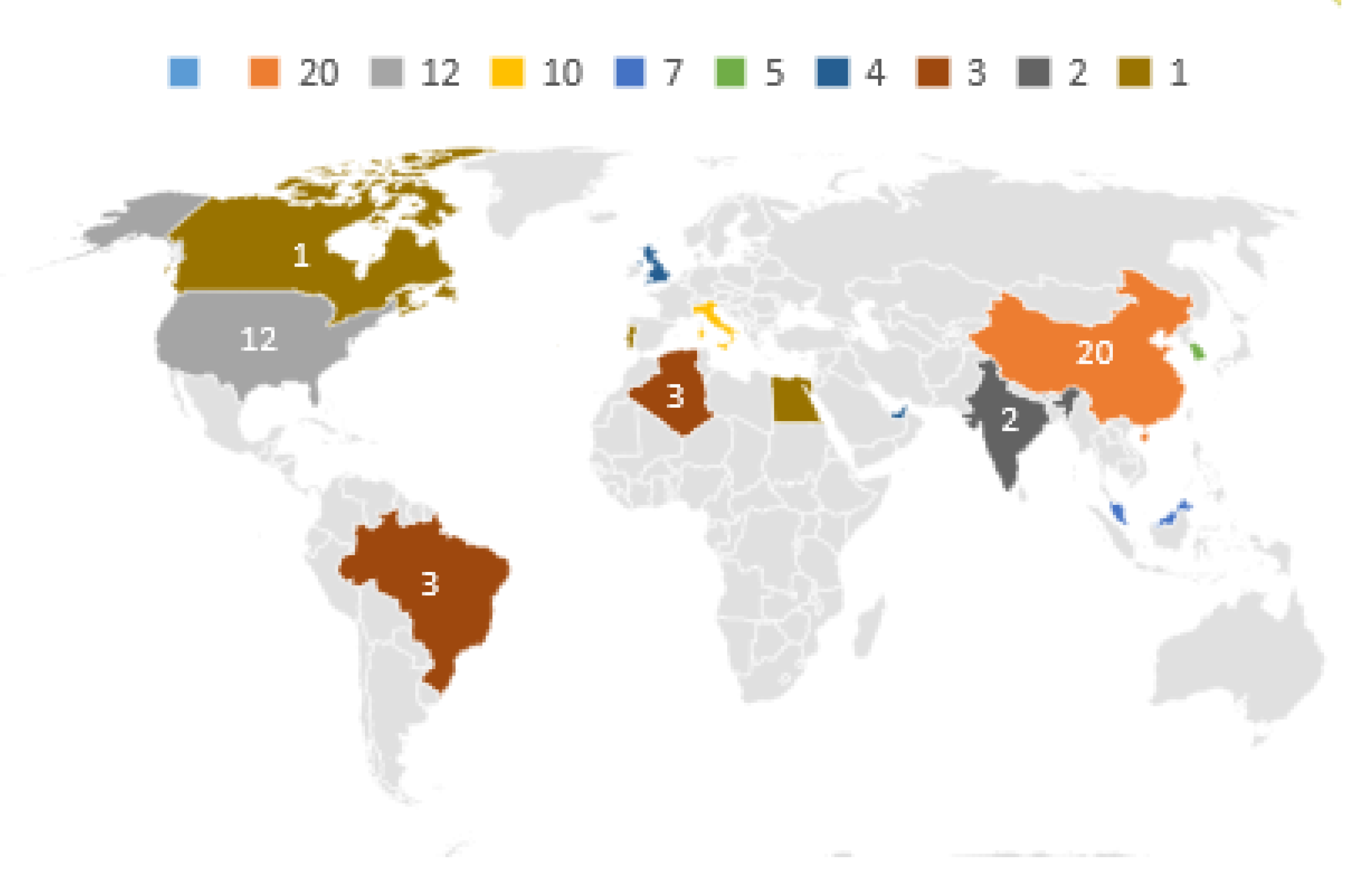
| Country | Quantity |
|---|---|
| China | 20 |
| USA | 12 |
| italy | 10 |
| Malaysia | 7 |
| South Korea | 5 |
| U.K. | 4 |
| UAE | 4 |
| Algeria | 3 |
| Brazil | 3 |
| India | 2 |
| Canada | 1 |
| Egypt | 1 |
| Hong Kong | 1 |
| Iraq | 1 |
| Portugal | 1 |
| Reference | Algorithm |
|---|---|
| [6] | PATP-Precision adjustable trajectory planning |
| [7] | Ant colony algorithm |
| [9] | TSP-ant Colony Optimization (ACO) |
| [10] | BL-TSP algorithm |
| [14] | Path based on the order of Hilbert values |
| [16] | Hilbert-Curve-based path planning algorithm |
| [17] | (TSP) and enhanced particle swarm optimization (EPSO) |
| [20] | Generalization of TSP |
| [21] | Simple area division cluster-based algorithm (SAD-CA) |
| [23] | Max-AoI-optimal and Ave-AoI-optimal |
| [24] | Stage-WSHP |
| Reference | Communication Technology |
|---|---|
| [5] | Bluetooth Low Energy (BLE) |
| [7] | A ZigBee wireless 2.4 GHz |
| [9] | Simple request/replay subGHz radio |
| [10] | 802.11b (no simulador) |
| [11] | LoRa e IEEE 802.11 ac (5ghz) |
| [12] | Simulador com IEEE 802.15.4 |
| [13] | ContikiMAC over the IEEE 802.15.4 2.4 GHz |
| [15] | WiFi |
| [16] | Device with the DTN protocol implemented |
| [17] | Multi-channel LoRaWAN® gateway |
| [19] | WiFi 802.11 2.4 GHz |
Publisher’s Note: MDPI stays neutral with regard to jurisdictional claims in published maps and institutional affiliations. |
© 2022 by the authors. Licensee MDPI, Basel, Switzerland. This article is an open access article distributed under the terms and conditions of the Creative Commons Attribution (CC BY) license (https://creativecommons.org/licenses/by/4.0/).
Share and Cite
Goulart, A.; Pinto, A.S.R.; Boava, A.; Branco, K. Data Collection in an IoT Off-Grid Environment Systematic Mapping of Literature. Sensors 2022, 22, 5374. https://doi.org/10.3390/s22145374
Goulart A, Pinto ASR, Boava A, Branco K. Data Collection in an IoT Off-Grid Environment Systematic Mapping of Literature. Sensors. 2022; 22(14):5374. https://doi.org/10.3390/s22145374
Chicago/Turabian StyleGoulart, Ademir, Alex Sandro Roschildt Pinto, Adão Boava, and Kalinka Branco. 2022. "Data Collection in an IoT Off-Grid Environment Systematic Mapping of Literature" Sensors 22, no. 14: 5374. https://doi.org/10.3390/s22145374
APA StyleGoulart, A., Pinto, A. S. R., Boava, A., & Branco, K. (2022). Data Collection in an IoT Off-Grid Environment Systematic Mapping of Literature. Sensors, 22(14), 5374. https://doi.org/10.3390/s22145374