
Applicability of Geomorphic Index for the Potential Slope Instability in the Three River Region, Eastern Tibetan Plateau

Abstract
:1. Introduction
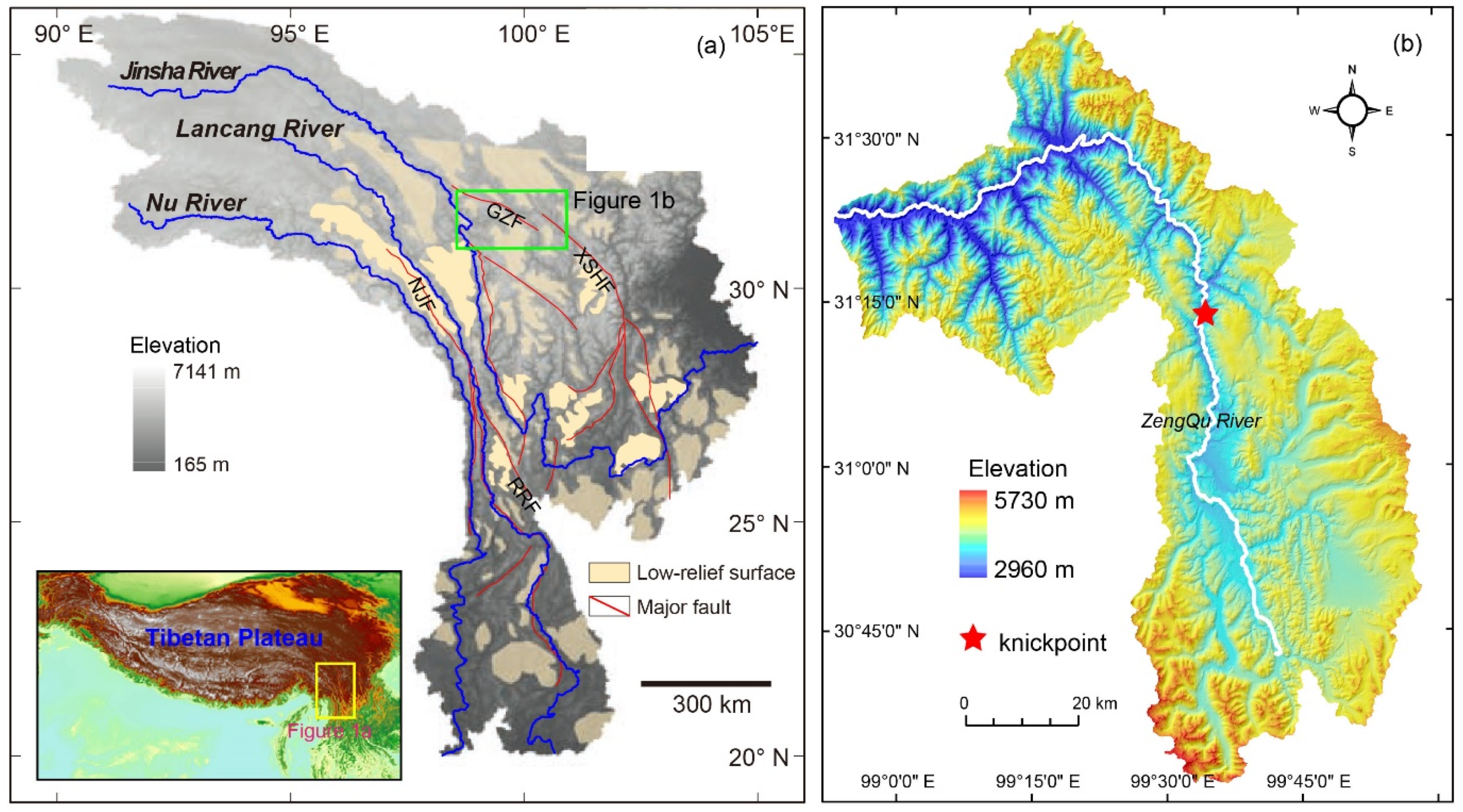
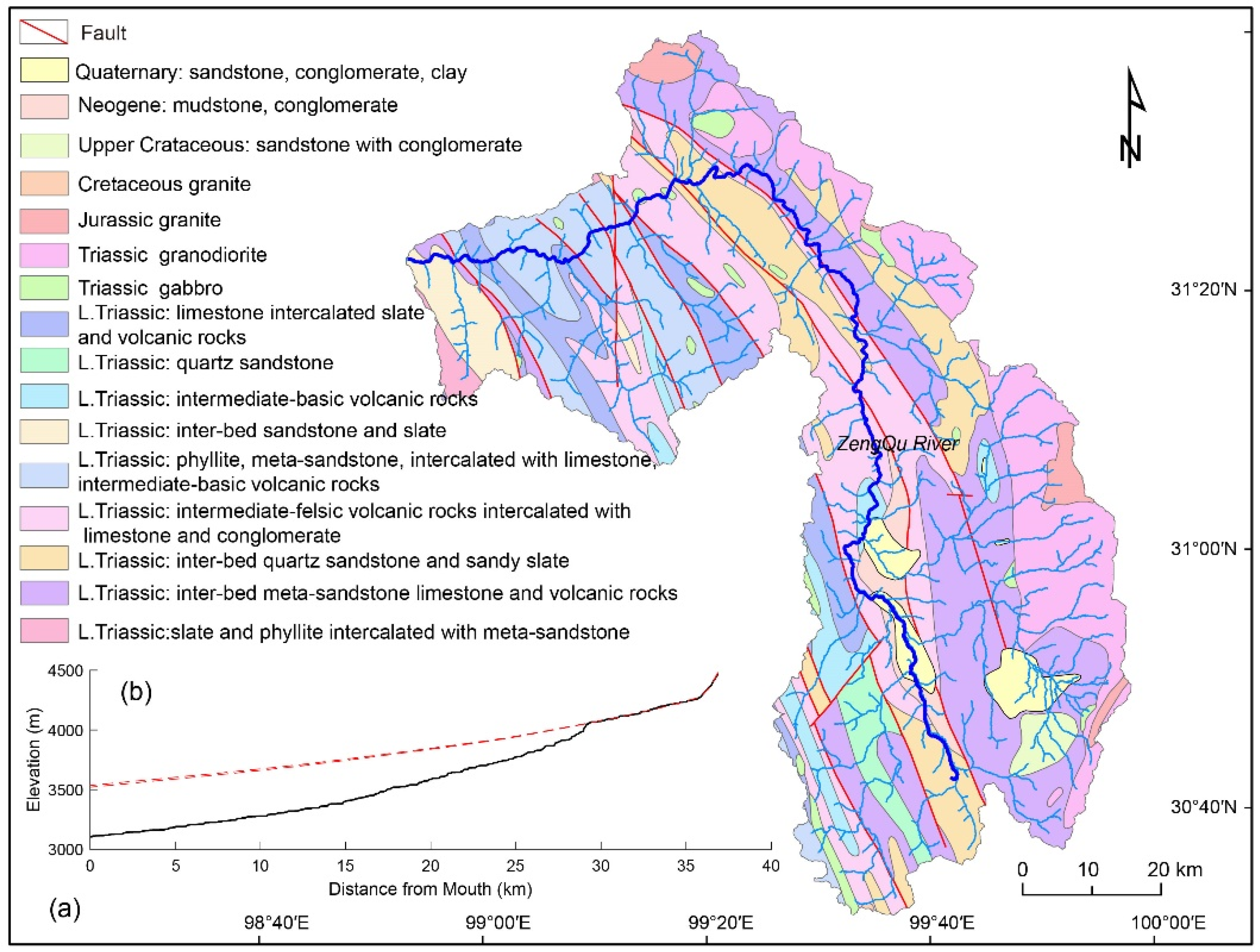
2. Study Area
3. Materials and Methods
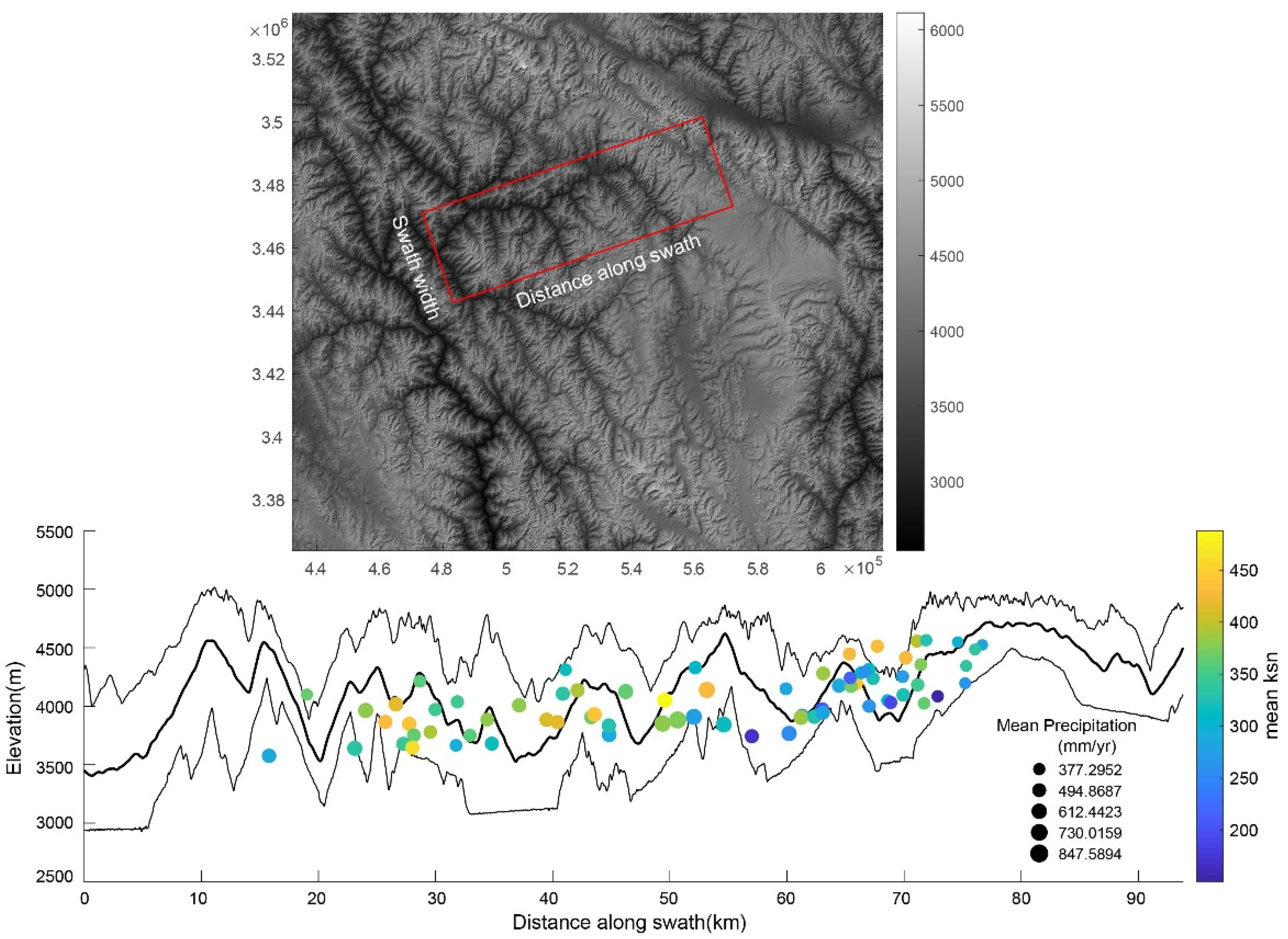
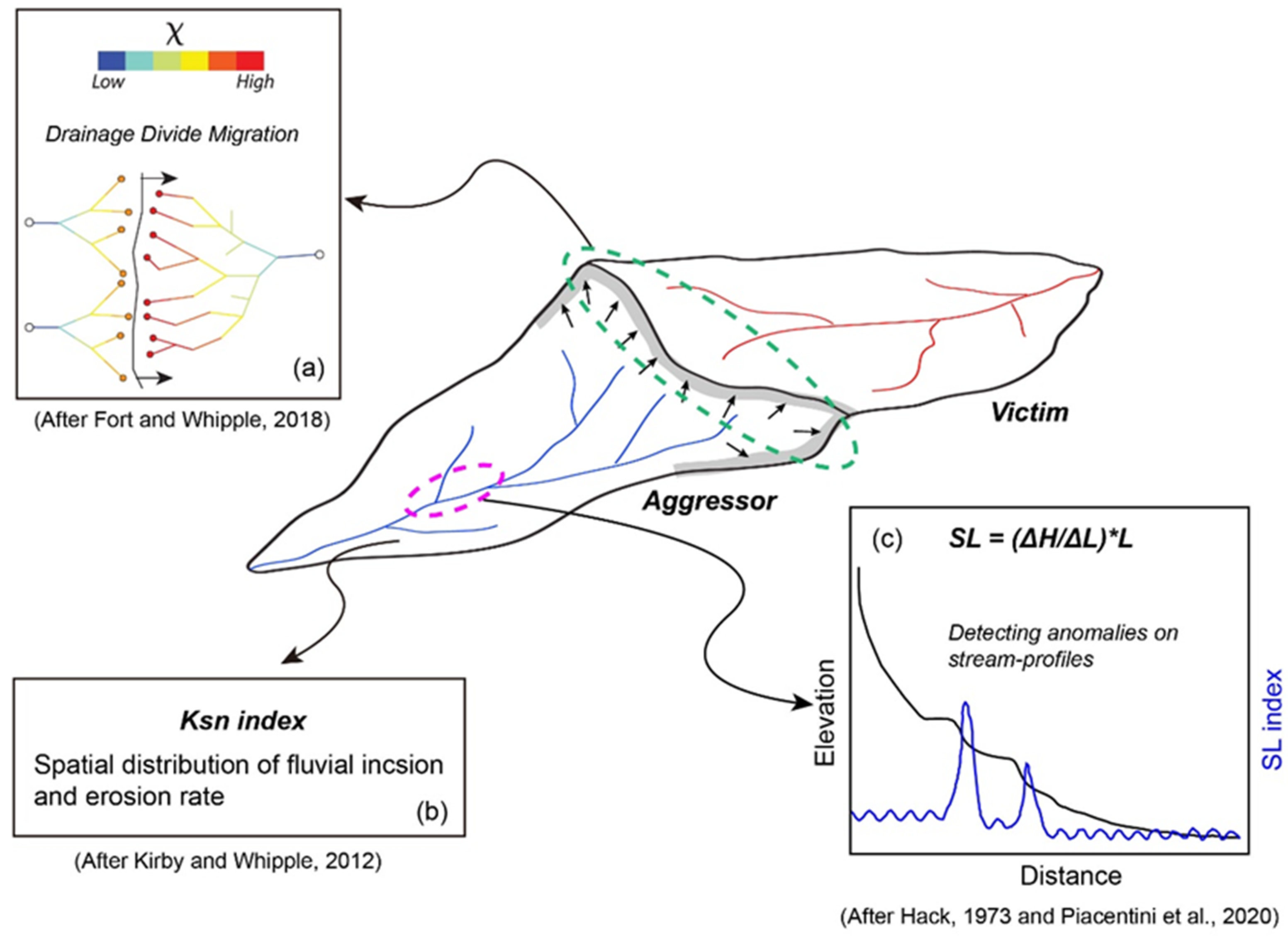
3.1. Channel Steepness Index
3.2. SL Index
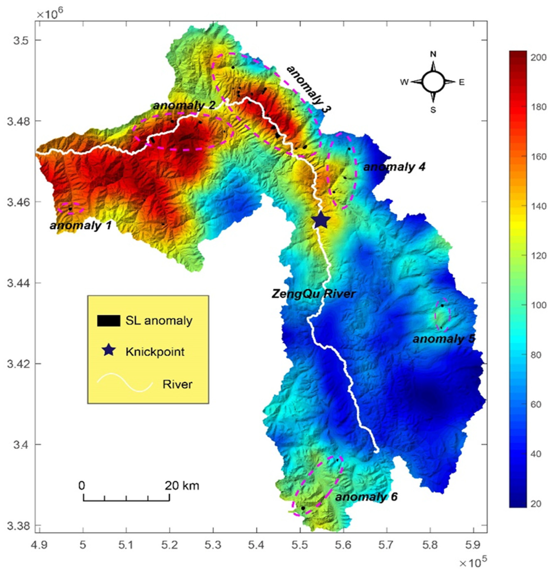
4. Results
5. Discussion
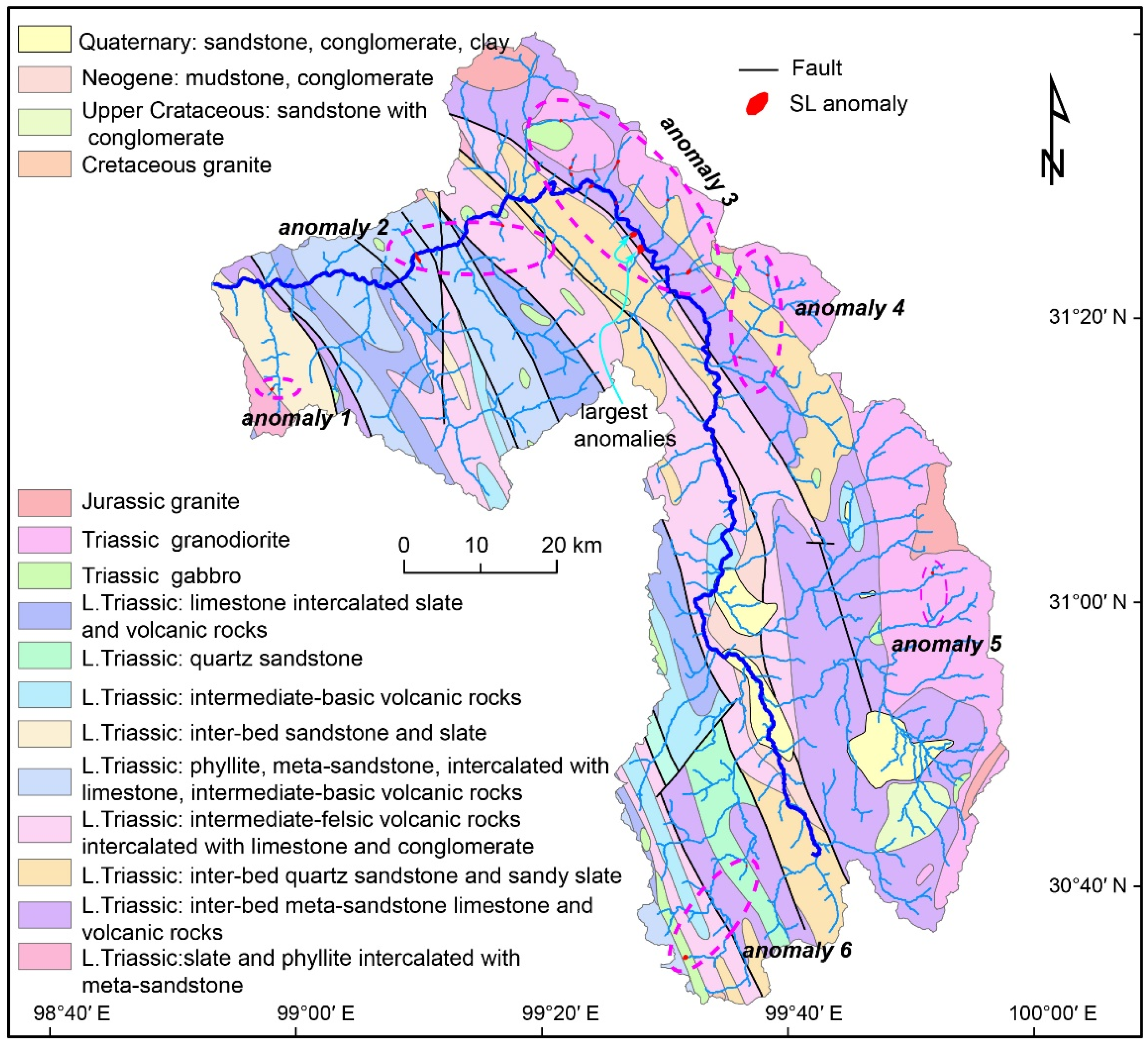
5.1. SL-HCA Anomalies and Potential Landslide Zones
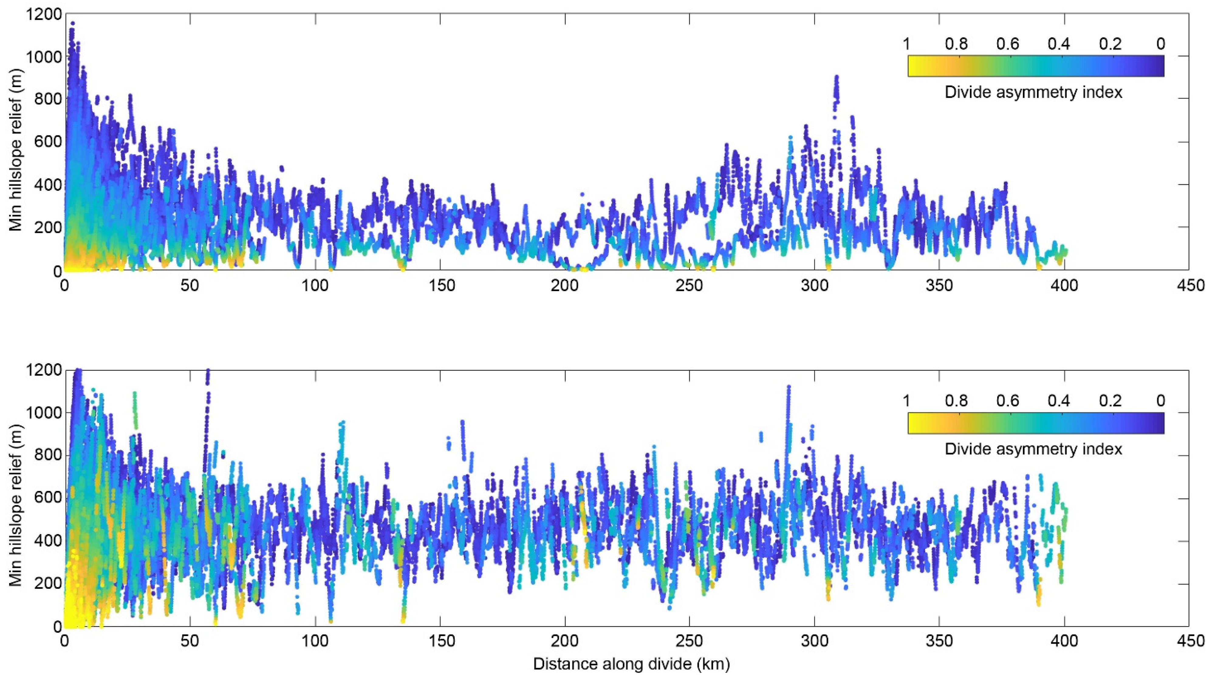
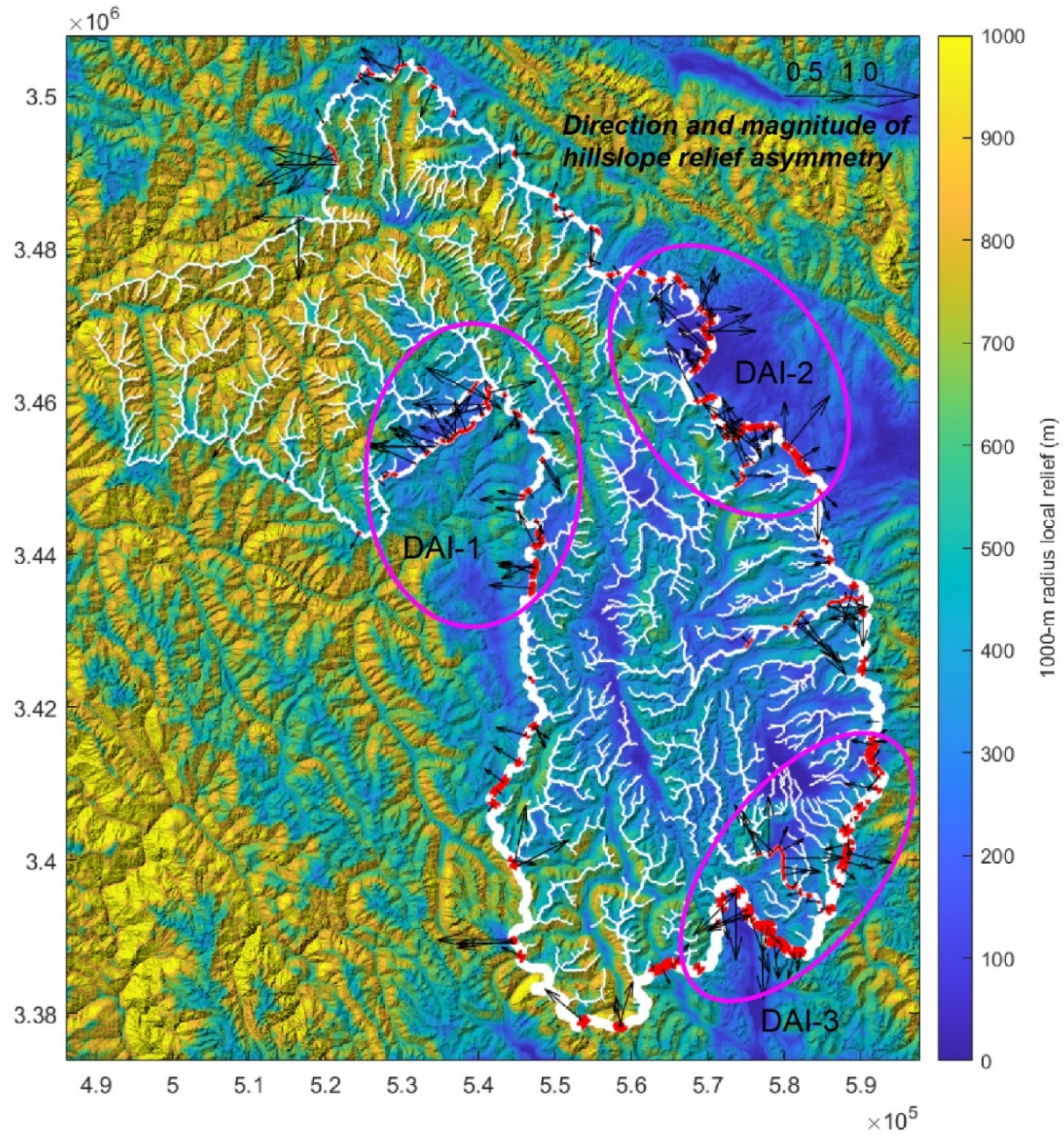
5.2. Divide Migration and the Potential Landslide Zones
6. Conclusions
Author Contributions
Funding
Institutional Review Board Statement
Informed Consent Statement
Data Availability Statement
Conflicts of Interest
References
- Densmore, A.L.; Anderson, R.S.; McAdoo, B.G.; Ellis, M.A. Hillslope Evolution by Bedrock Landslides. Science 1997, 275, 369–372. [Google Scholar] [CrossRef] [Green Version]
- Roering, J.J. Landslides limit mountain relief. Nat. Geosci. 2012, 5, 446–447. [Google Scholar] [CrossRef]
- Gutiérrez, F.; Soldati, M.; Audemard, F.; Balteanu, D. Recent advances in landslide investigation: Issues and perspec-tives. Geomorphology 2010, 124, 95–101. [Google Scholar] [CrossRef]
- Chalkias, C.; Polykretis, C.; Karymbalis, E.; Soldati, M.; Ghinoi, A.; Ferentinou, M. Exploring spatial non-stationarity in the relationships between landslide susceptibility and conditioning factors: A local modeling approach using geographically weighted regression. Bull. Int. Assoc. Eng. Geol. 2020, 79, 2799–2814. [Google Scholar] [CrossRef]
- Guzzetti, F.; Carrara, A.; Cardinali, M.; Reichenbach, P. Landslide hazard evaluation: A review of current tech-niques and their application in a multi-scale study, Central Italy. Geomorphology 1999, 31, 181–216. [Google Scholar] [CrossRef]
- Van Westen, C.J.; Castellanos, E.; Kuriakose, S.L. Spatial data for landslide susceptibility, hazard, and vulnerability assessment: An overview. Eng. Geol. 2008, 102, 112–131. [Google Scholar] [CrossRef]
- Ray, R.L.; Lazzari, M.; Olutimehin, T. Remote sensing approaches and related techniques to map and study land-slides. In Landslides; Ray, R., Lazzari, M., Eds.; Intech Open: Rijeka, Croatia, 2020. [Google Scholar]
- Prakash, N.; Manconi, A.; Loew, S. Mapping Landslides on EO Data: Performance of Deep Learning Models vs. Traditional Machine Learning Models. Remote Sens. 2020, 12, 346. [Google Scholar] [CrossRef] [Green Version]
- Mondini, A.C.; Guzzetti, F.; Chang, K.-T.; Monserrat, O.; Martha, T.R.; Manconi, A. Landslide failures detection and mapping using Synthetic Aperture Radar: Past, present and future. Earth-Sci. Rev. 2021, 216, 103574. [Google Scholar] [CrossRef]
- Solari, L.; Del Soldato, M.; Raspini, F.; Barra, A.; Bianchini, S.; Confuorto, P.; Casagli, N.; Crosetto, M. Review of Satellite Interferometry for Landslide Detection in Italy. Remote Sens. 2020, 12, 1351. [Google Scholar] [CrossRef]
- Burbank, D.W.; Anderson, R.S. Tectonic Geomorphology; Blackwell Science: Oxford, UK, 2012. [Google Scholar]
- El Hamdouni, R.; Irigaray, C.; Jiménez-Perálvarez, J.D.; Chacón, J. Correlations analysis between landslides and stream length-gradient (SL) index in the southern slopes of Sierra Nevada (Granada, Spain). In Geologically Active; Williams, A.L., Pinches, G.M., Chin, C.Y., McMorran, T.J., Massey, C.Y., Eds.; Taylor and Francis Group: London, UK, 2010; pp. 141–149. [Google Scholar]
- Troiani, F.; Galve, J.P.; Piacentini, D.; Della Seta, M.; Guerrero, J. Spatial analysis of stream length-gradient (SL) index for detecting hillslope processes: A case of the Gállego River headwaters (Central Pyrenees, Spain). Geomorphology 2014, 214, 183–197. [Google Scholar] [CrossRef]
- Troiani, F.; Piacentini, D.; Della Seta, M.; Galve, J.P. Stream Length-gradient Hotspot and Cluster Analysis (SL–HCA ) to fine-tune the detection and interpretation of knickzones on longitudinal profiles. Catena 2017, 156, 30–41. [Google Scholar] [CrossRef]
- Subiela, G.B.; Guinau, M.; Galve, J.P.; Ortuño, M.; Viaplana-Muzas, M.; Pérez-Peña, J.V. Suitability of geomorphological indices for the automatic identification of landslides affecting the drainage network: Examples from the Pyrenees. In Proceedings of the 20th EGU General Assembly, Vienna, Austria, 4–13 April 2018. [Google Scholar]
- Tapponnier, P.; Peltzer, G.; Armijo, R. On the mechanics of the collision between India and Asia. Geol. Soc. Lond. Spéc. Publ. 1986, 19, 113–157. [Google Scholar] [CrossRef]
- Tapponnier, P.; Zhiqin, X.; Roger, F.; Meyer, B.; Arnaud, N.; Wittlinger, G.; Jingsui, Y. Oblique Stepwise Rise and Growth of the Tibet Plateau. Science 2001, 294, 1671–1677. [Google Scholar] [CrossRef]
- Wang, E.; Burchfiel, B.C.; Royden, L.H.; Chen, L.; Chen, J.; Li, W.; Chen, Z.; Wang, E.; Burchfiel, B.C.; Royden, L.H.; et al. Late Cenozoic Xianshuihe-Xiaojiang, Red River, and Dali Fault Systems of Southwestern Sichuan and Central Yunnan, China; Geological Society of America: Boulder, CO, USA, 1998; pp. 1–108. [Google Scholar]
- Taylor, M.; Yin, A. Active structures of the Himalayan-Tibetan orogen and their relationships to earthquake dis-tribution, contemporary strain field, and Cenozoic volcanism. Geosphere 2009, 5, 199–214. [Google Scholar] [CrossRef] [Green Version]
- Henck, A.C.; Huntington, K.W.; Stone, J.O.; Montgomery, D.R.; Hallet, B. Spatial controls on erosion in the Three Rivers Region, southeastern Tibet and southwestern China. Earth Planet. Sci. Lett. 2011, 303, 71–83. [Google Scholar] [CrossRef]
- Clark, M.K.; Royden, L.H.; Whipple, K.X.; Burchfiel, B.C.; Zhang, X.; Tang, W. Use of a regional, relict landscape to measure vertical deformation of the eastern Tibetan Plateau. J. Geophys. Res. Space Phys. 2006, 111. [Google Scholar] [CrossRef] [Green Version]
- Fox, M.; Carter, A.; Dai, J.-G. How Continuous Are the “Relict” Landscapes of Southeastern Tibet? Front. Earth Sci. 2020, 8. [Google Scholar] [CrossRef]
- Liu-Zeng, J.; Tapponnier, P.; Gaudemer, Y.; Ding, L. Quantifying landscape differences across the Tibetan plateau: Implications for topographic relief evolution. J. Geophys. Res. Space Phys. 2008, 113. [Google Scholar] [CrossRef] [Green Version]
- Yang, R.; Fellin, M.G.; Herman, F.; Willett, S.D.; Wang, W.; Maden, C. Spatial and temporal pattern of erosion in the Three Rivers Region, southeastern Tibet. Earth Planet. Sci. Lett. 2016, 433, 10–20. [Google Scholar] [CrossRef]
- Kirby, E.; Whipple, K. Quantifying differential rock-uplift rates via stream profile analysis. Geology 2001, 29, 415–418. [Google Scholar] [CrossRef]
- Ouimet, W.B.; Whipple, K.X.; Granger, D.E. Beyond threshold hillslopes: Channel adjustment to base-level fall in tectonically active mountain ranges. Geology 2009, 37, 579–582. [Google Scholar] [CrossRef]
- Whipple, K.X.; Forte, A.M.; DiBiase, R.A.; Gasparini, N.M.; Ouimet, W.B. Timescales of landscape response to divide migration and drainage capture: Implications for the role of divide mobility in landscape evolution. J. Geophys. Res. Earth Surf. 2017, 122, 248–273. [Google Scholar] [CrossRef]
- Gallen, S.F. Lithologic controls on landscape dynamics and aquatic species evolution in post-orogenic mountains. Earth Planet. Sci. Lett. 2018, 493, 150–160. [Google Scholar] [CrossRef]
- Kirby, E.; Whipple, K.X. Expression of active tectonics in erosional landscapes. J. Struct. Geol. 2012, 44, 54–75. [Google Scholar] [CrossRef]
- Murphy, B.P.; Johnson, J.P.L.; Gasparini, N.M.; Sklar, L.S. Chemical weathering as a mechanism for the climatic control of bedrock river incision. Nat. Cell Biol. 2016, 532, 223–227. [Google Scholar] [CrossRef] [PubMed]
- Flint, J.J. Stream gradient as a function of order, magnitude, and discharge. Water Resour. Res. 1974, 10, 969–973. [Google Scholar] [CrossRef]
- Howard, A.; Kerby, G. Channel changes in badlands. GSA Bull. 1983, 94, 739–752. [Google Scholar] [CrossRef]
- Montgomery, D.R.; Foufoula-Georgiou, E. Channel network source representation using digital elevation models. Water Resour. Res. 1993, 29, 3925–3934. [Google Scholar] [CrossRef]
- Wobus, C.; Whipple, K.X.; Kirby, E.; Snyder, N.; Johnson, J.; Spyropolou, K.; Crosby, B.; Sheehan, D. Tectonics from topography: Procedures, promise, and pitfalls. In Special Paper 398: Tectonics, Climate, and Landscape Evolution; Geological Society of America: Boulder, CO, USA, 2006; pp. 55–74. [Google Scholar]
- DiBiase, R.; Whipple, K.X.; Heimsath, A.M.; Ouimet, W.B. Landscape form and millennial erosion rates in the San Gabriel Mountains, CA. Earth Planet. Sci. Lett. 2010, 289, 134–144. [Google Scholar] [CrossRef]
- Safran, E.B.; Bierman, P.R.; Aalto, R.; Dunne, T.; Whipple, K.X.; Caffee, M. Erosion rates driven by channel network incision in the Bolivian Andes. Earth Surf. Process. Landf. 2005, 30, 1007–1024. [Google Scholar] [CrossRef]
- Forte, A.M.; Whipple, K.X.; Bookhagen, B.; Rossi, M.W. Decoupling of modern shortening rates, climate, and to-pography in the Caucasus. Earth Planet. Sci. Lett. 2016, 449, 282–294. [Google Scholar] [CrossRef] [Green Version]
- Perron, J.T.; Royden, L.H. An integral approach to bedrock river profile analysis. Earth Surf. Process. Landf. 2013, 38, 570–576. [Google Scholar] [CrossRef] [Green Version]
- Willett, S.D.; McCoy, S.W.; Perron, J.T.; Goren, L.; Chen, C.-Y. Dynamic Reorganization of River Basins. Science 2014, 343, 1248765. [Google Scholar] [CrossRef]
- Dahlquist, M.; West, A.J.; Li, G. Landslide-driven drainage divide migration. Geology 2018, 46, 403–406. [Google Scholar] [CrossRef]
- Whipple, K.X. The influence of climate on the tectonic evolution of mountain belts. Nat. Geosci. 2009, 2, 97–104. [Google Scholar] [CrossRef]
- Whipple, K.X.; Tucker, G. Dynamics of the stream-power river incision model: Implications for height limits of mountain ranges, landscape response timescales, and research needs. J. Geophys. Res. Space Phys. 1999, 104, 17661–17674. [Google Scholar] [CrossRef]
- Forte, A.M.; Whipple, K.X. Criteria and tools for determining drainage divide stability. Earth Planet. Sci. Lett. 2018, 493, 102–117. [Google Scholar] [CrossRef] [Green Version]
- Scherler, D.; Schwanghart, W. Drainage divide networks—Part 1: Identification and ordering in digital elevation models. Earth Surf. Dyn. 2020, 8, 245–259. [Google Scholar] [CrossRef] [Green Version]
- Schwanghart, W.; Scherler, D. Short Communication: TopoToolbox 2—MATLAB-based software for topographic analysis and modeling in Earth surface sciences. Earth Surf. Dyn. 2014, 2, 1–7. [Google Scholar] [CrossRef] [Green Version]
- Hack, J.T. Stream-profile analysis and stream-gradient index. J. Res. US Geol. Surv. 1973, 1, 421–429. [Google Scholar]
- Keller, E.A.; Pinter, N. Active Tectonics: Earthquakes, Uplift, and Landscape; Prentice Hall: Upper Saddle River, NJ, USA, 2002. [Google Scholar]
- Piacentini, D.; Troiani, F.; Servizi, T.; Nesci, O.; Veneri, F. SLiX: A GIS Toolbox to Support Along-Stream Knickzones Detection through the Computation and Mapping of the Stream Length-Gradient (SL) Index. ISPRS Int. J. Geo-Inf. 2020, 9, 69. [Google Scholar] [CrossRef] [Green Version]
- Bermúdez, M.A.; Velandia, F.; García-Delgado, H.; Jiménez, D.; Bernet, M. Exhumation of the southern transpres-sive Bucaramanga fault, eastern Cordillera of Colombia: Insights from detrital, quantitative thermochronology and geo-morphology. J. S. Am. Earth Sci. 2021, 106, 103057. [Google Scholar] [CrossRef]
- Whipple, K.; DiBiase, R.; Crosby, B. 9.28 Bedrock Rivers. In Treatise on Geomorphology; Shroder, J.F., Ed.; Academic Press: San Diego, CA, USA, 2013; pp. 550–573. [Google Scholar]
- Yang, R.; Willett, S.D.; Goren, L. In situ low-relief landscape formation as a result of river network disruption. Nat. Cell Biol. 2015, 520, 526–529. [Google Scholar] [CrossRef] [PubMed]
- Lavé, J. Landscape inversion by stream piracy. Nat. Cell Biol. 2015, 520, 442–443. [Google Scholar] [CrossRef] [PubMed]


Publisher’s Note: MDPI stays neutral with regard to jurisdictional claims in published maps and institutional affiliations. |
© 2021 by the authors. Licensee MDPI, Basel, Switzerland. This article is an open access article distributed under the terms and conditions of the Creative Commons Attribution (CC BY) license (https://creativecommons.org/licenses/by/4.0/).
Share and Cite
Liu, F.; Yao, X.; Li, L. Applicability of Geomorphic Index for the Potential Slope Instability in the Three River Region, Eastern Tibetan Plateau. Sensors 2021, 21, 6505. https://doi.org/10.3390/s21196505
Liu F, Yao X, Li L. Applicability of Geomorphic Index for the Potential Slope Instability in the Three River Region, Eastern Tibetan Plateau. Sensors. 2021; 21(19):6505. https://doi.org/10.3390/s21196505
Chicago/Turabian StyleLiu, Feng, Xin Yao, and Lingjing Li. 2021. "Applicability of Geomorphic Index for the Potential Slope Instability in the Three River Region, Eastern Tibetan Plateau" Sensors 21, no. 19: 6505. https://doi.org/10.3390/s21196505
APA StyleLiu, F., Yao, X., & Li, L. (2021). Applicability of Geomorphic Index for the Potential Slope Instability in the Three River Region, Eastern Tibetan Plateau. Sensors, 21(19), 6505. https://doi.org/10.3390/s21196505