SAR and Optical Data Comparison for Detecting Co-Seismic Slip and Induced Phenomena during the 2018 Mw 7.5 Sulawesi Earthquake


Abstract
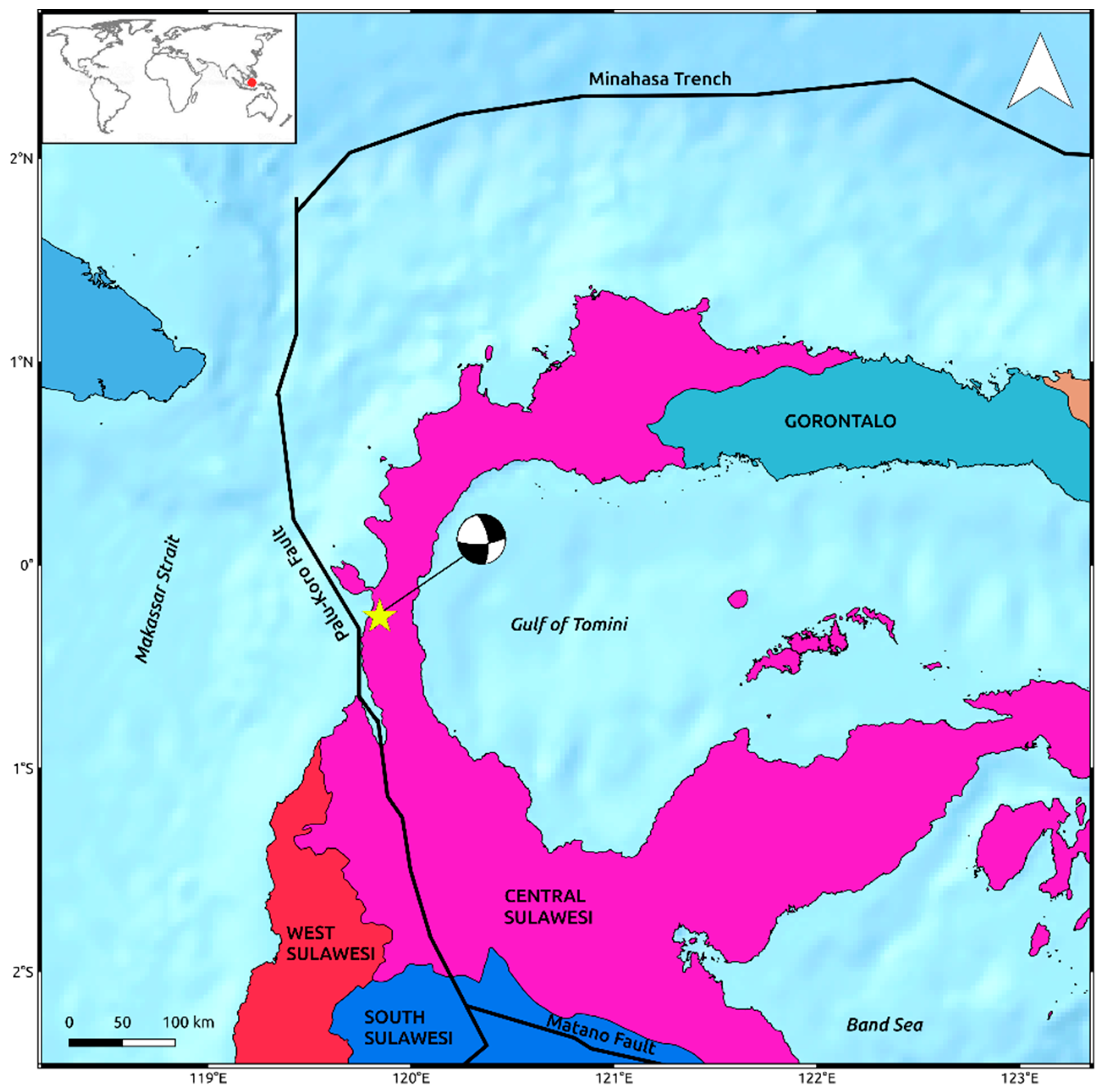
1. Introduction
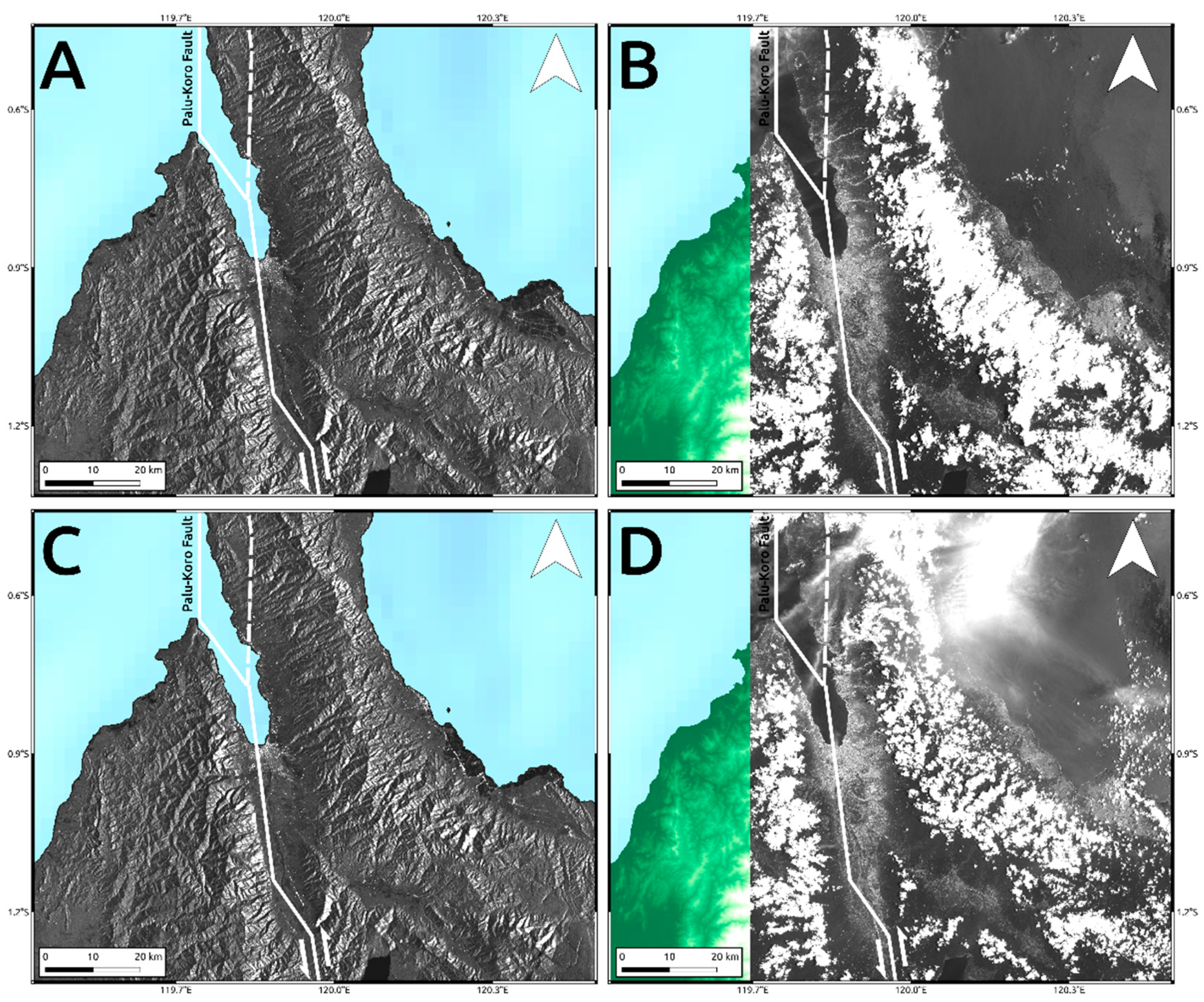
2. SAR Data
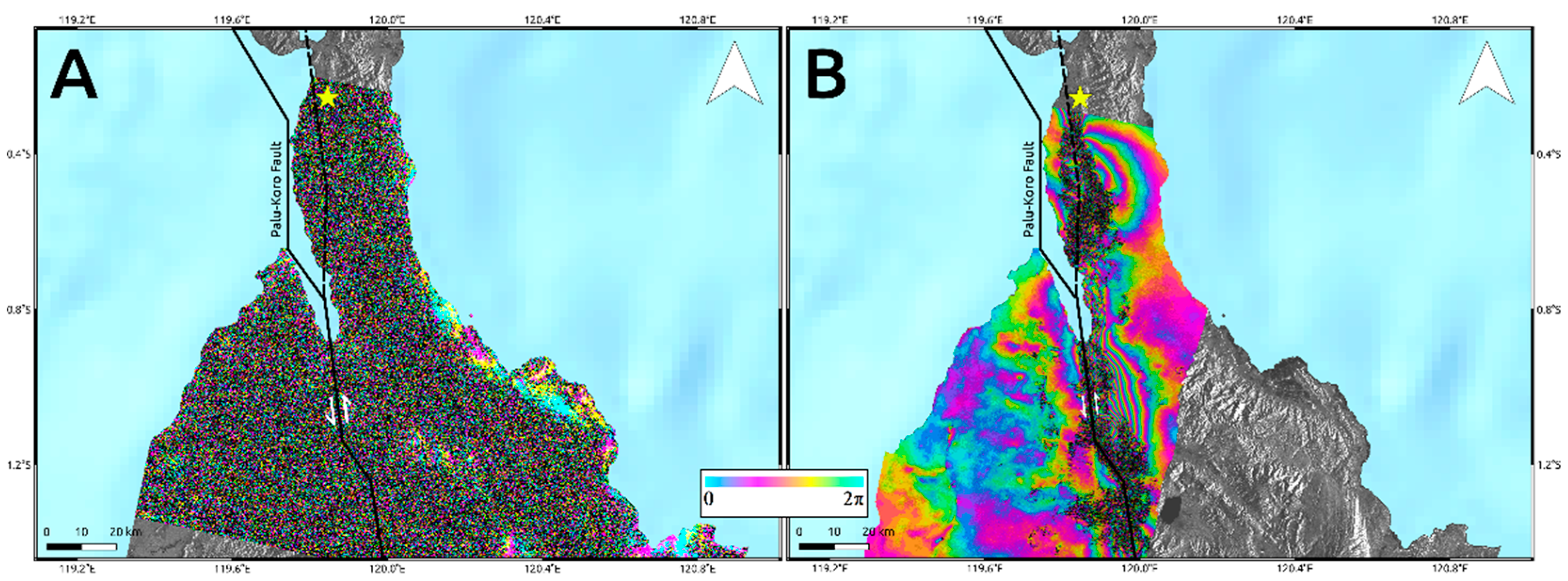
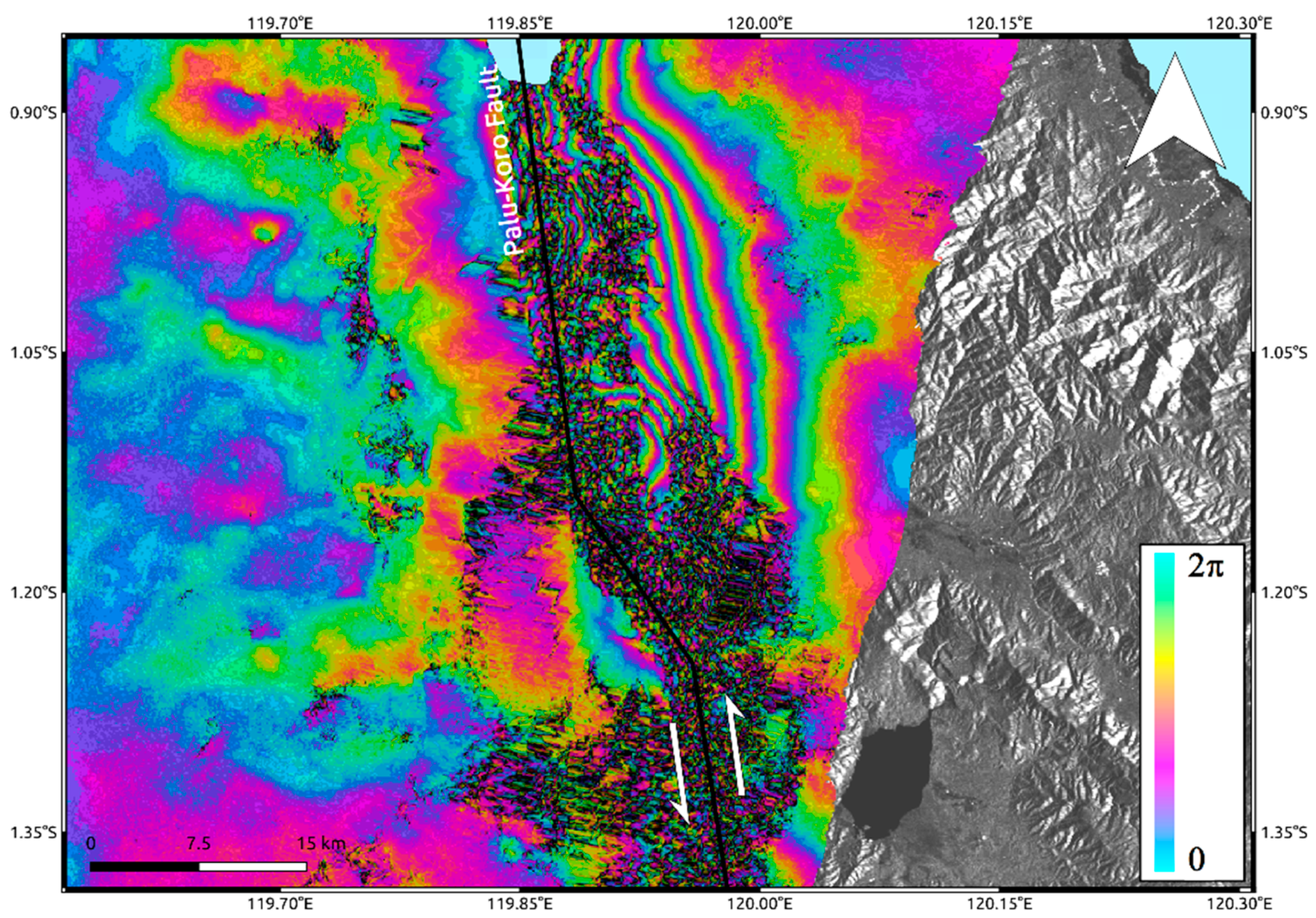
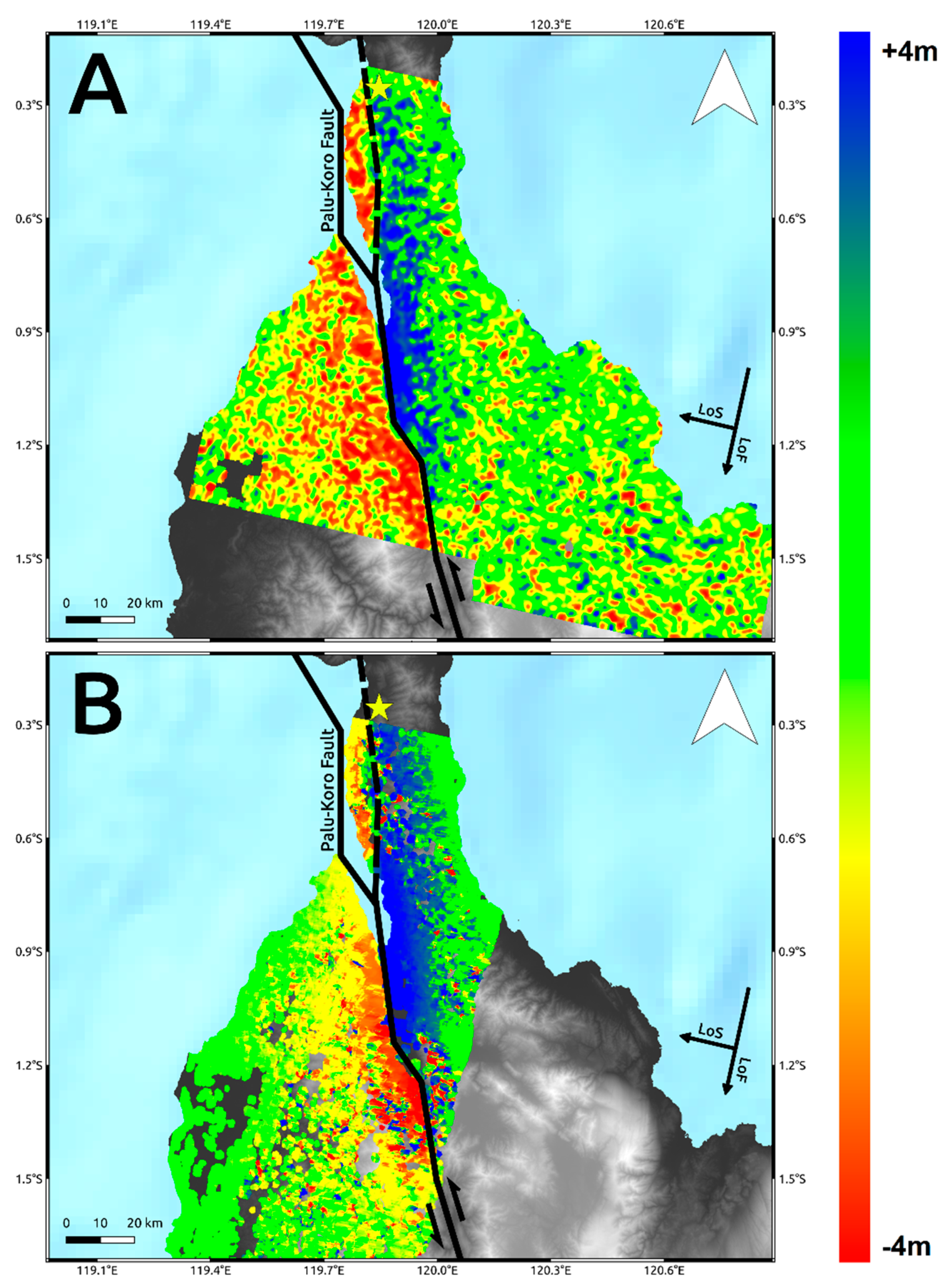
2.1. InSAR Outcomes
2.2. POT Outcomes
3. Optical Data
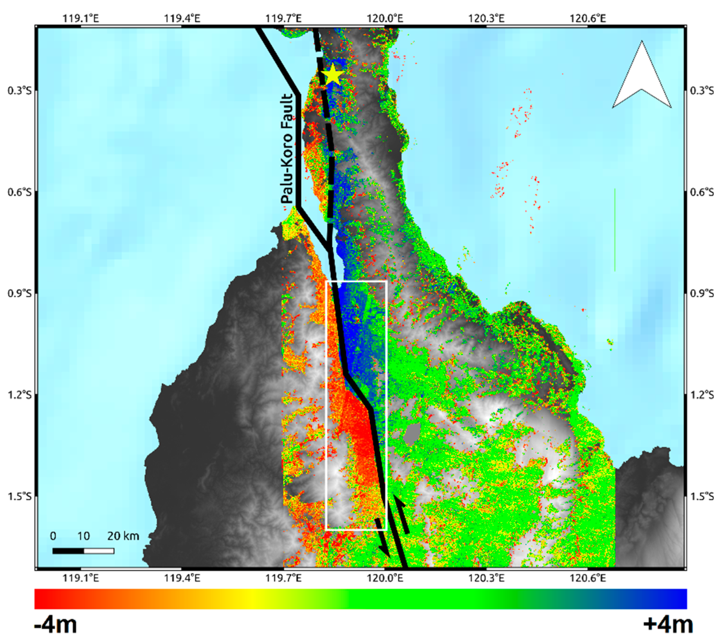
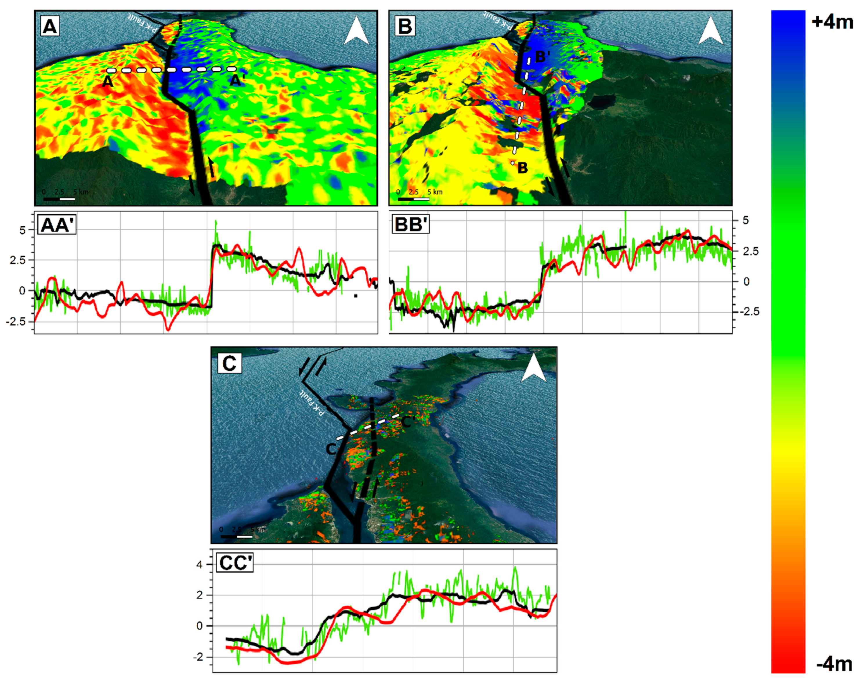
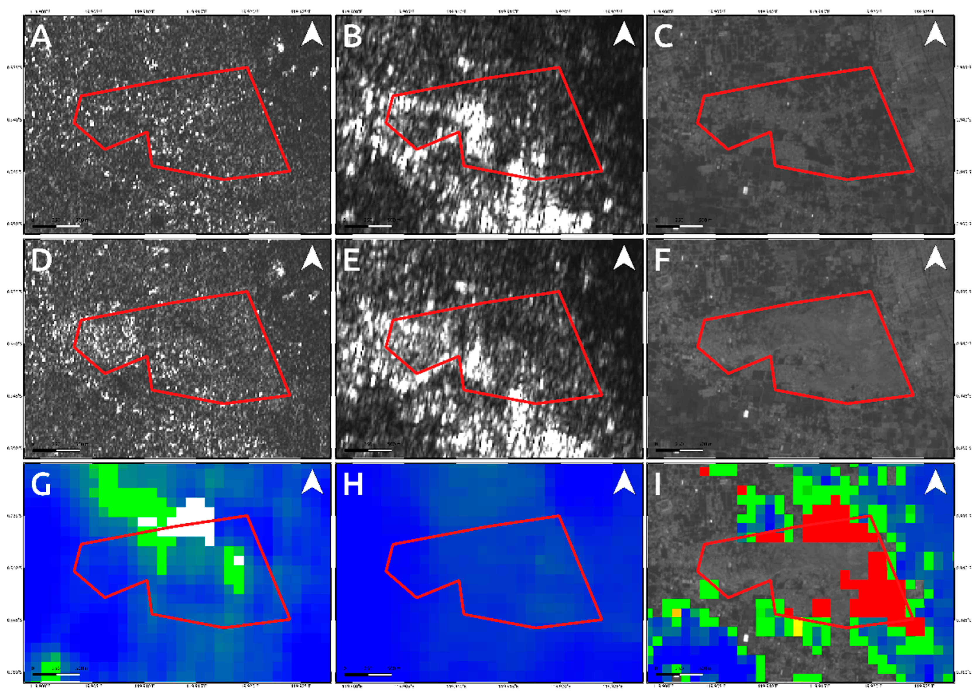
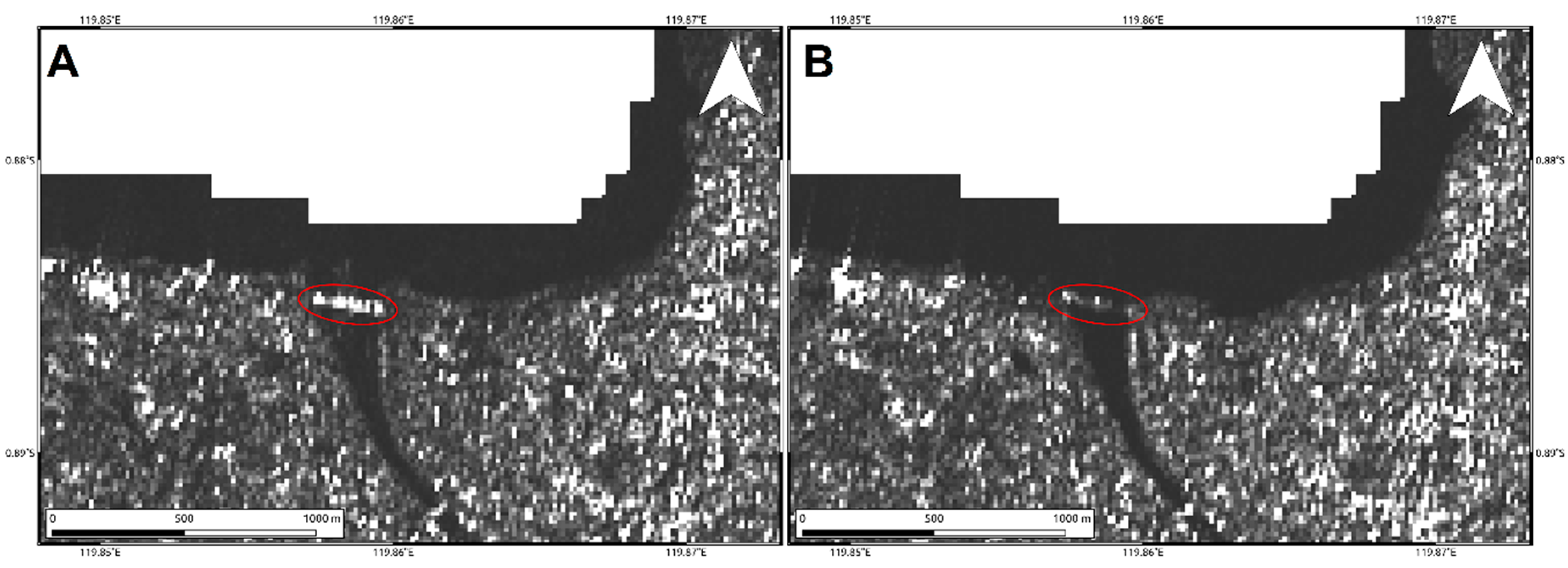
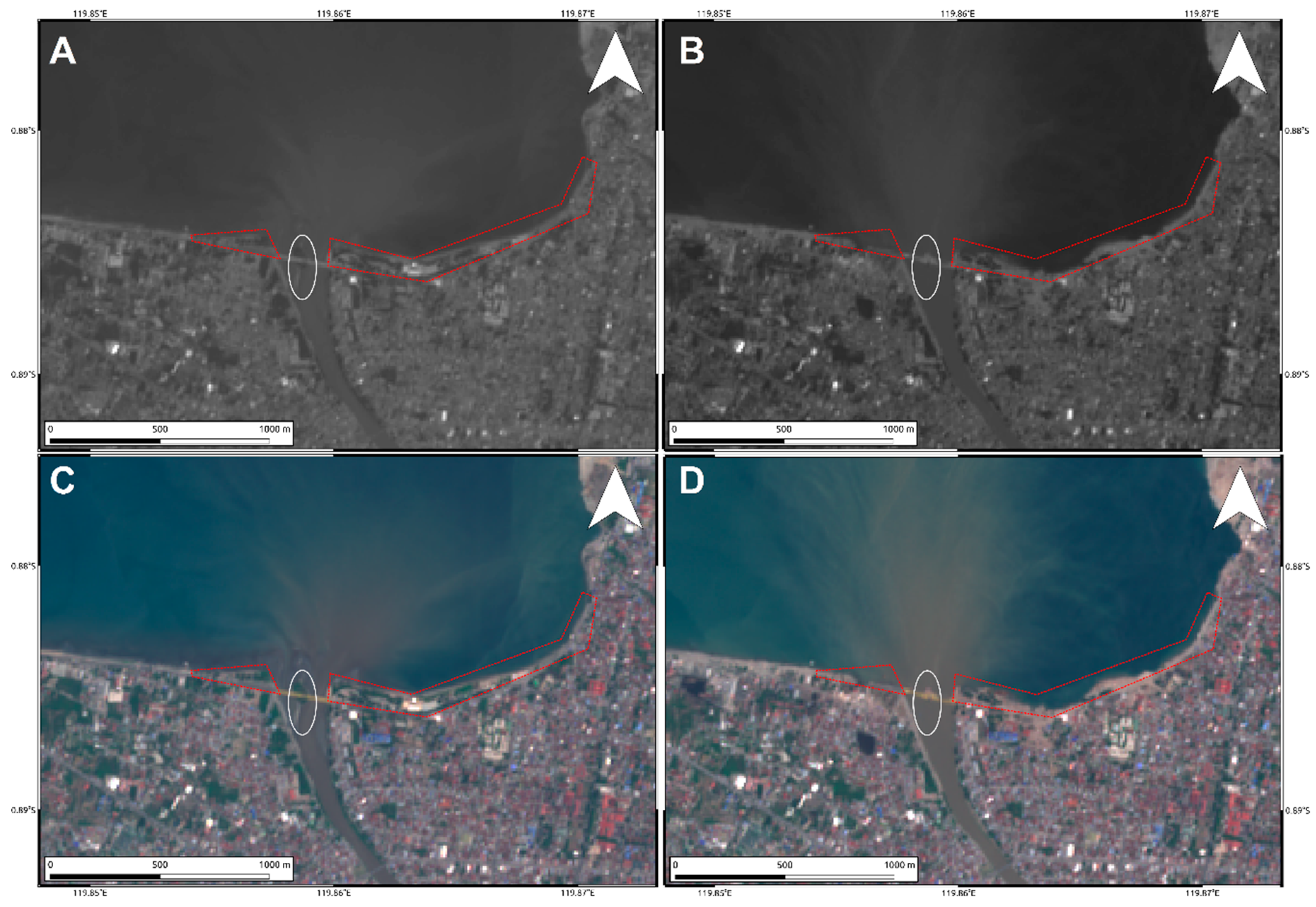
4. Results
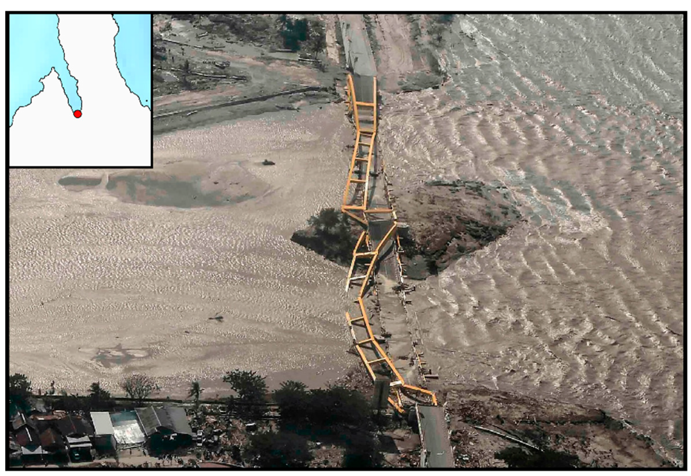
5. Discussion
6. Conclusions
Author Contributions
Funding
Acknowledgments
Conflicts of Interest
References
- Sassa, S.; Takagawa, T. Liquefied gravity flow-induced tsunami: First evidence and comparison from the 2018 Indonesia Sulawesi earthquake and tsunami disasters. Landslides 2019, 16, 195–200. [Google Scholar] [CrossRef]
- Heidarzadeh, M.; Muhari, A.; Wijanarto, A.B. Insights on the Source of the 28 September 2018 Sulawesi Tsunami, Indonesia Based on Spectral Analyses and Numerical Simulations. Pure Appl. Geophys. 2019, 176, 25–43. [Google Scholar] [CrossRef]
- Omira, R.; Dogan, G.G.; Hidayat, R.; Husrin, S.; Prasetya, G.; Annunziato, A.; Proietti, C.; Probst, P.; Paparo, M.A.; Wronna, M.; et al. The September 28th, 2018, Tsunami In Palu-Sulawesi, Indonesia: A Post-Event Field Survey. Pure Appl. Geophys. 2019, 176, 1379–1395. [Google Scholar] [CrossRef]
- Carvajal, M.; Araya-Cornejo, C.; Sepulveda, I.; Melnick, D.; Haase, J.S. Nearly instantaneous tsunamis following the Mw 7.5 2018 Palu earthquake. Geophys. Res. Lett. 2019, 46, 5117–5126. [Google Scholar] [CrossRef]
- United States Geological Survey (USGS). Available online: https://earthquake.usgs.gov/ (accessed on 18 December 2018).
- Wallace, L.M.; Stevens, C.; Silver, E.; McCaffrey, R.; Loratung, W.; Hasiata, S.; Stanaway, R.; Curley, R.; Rosa, R.; Taugaloidi, J. GPS and seismological constraints on active tectonics and arc-continent collision in Papua New Guinea: Implications for mechanics of microplate rotations in a plate boundary zone. J. Geophys. Res.: Sol. Ea. 2004, 109, B5. [Google Scholar] [CrossRef]
- Soquet, A.; Simons, W.; Vigny, C.; McCaffrey, R.; Subarya, C.; Sarsito, D.; Ambrosius, B.; Spakman, W. Microblock rotations and fault coupling in SE Asia triple junction (Sulawesi, Indonesia) from GPS and earthquake slip vector data. J. Geophys. Res. Sol. Ea. 2006, 111, B8. [Google Scholar] [CrossRef]
- Walpersdorf, A.; Vigny, C. Monitoring of the Palu-Koro Fault (Sulawesi) by GPS. Geophys. Res. Lett. 1998, 25, 2313–2316. [Google Scholar] [CrossRef]
- Bellier, O.; Sebrier, M.; Beaudouin, T.; Villeneuve, M.; Braucher, R.; Bourles, D.; Siame, L.; Putranto, E.; Pratomo, I. High slip rate for a low seismicity along the Palu-Koro active fault in central Sulawesi (Indonesia). Terra Nova 2001, 13, 463–470. [Google Scholar] [CrossRef]
- Watkinson, I.M.; Hall, R. Fault systems of the eastern Indonesian triple junction: Evaluation of Quaternary activity and implications for seismic hazards. Geol. Soc. SP. 2017, 441, 71–120. [Google Scholar] [CrossRef]
- Bao, H.; Ampuero, J.P.; Meng, L.; Fielding, E.J.; Liang, C.; Milliner, C.W.D.; Feng, T.; Huang, H. Early and persistent supershear rupture of the 2018 magnitude 7.5 Palu earthquake. Nat. Geosci. 2019, 200, 200–205. [Google Scholar] [CrossRef]
- Socquet, A.; Hollingsworth, J.; Pathier, E.; Bouchon, M. Evidence of supershear during the 2018 magnitude 7.5 Palu earthquake from space geodesy. Nat. Geosci. 2019, 12, 192–199. [Google Scholar] [CrossRef]
- Massonnet, D.; Rossi, M.; Carmona, C.; Adragna, F.; Peltzer, G.; Feigl, K.; Rabaute, T. The displacement field of the Landers earthquake mapped by radar interferometry. Nature 1993, 364, 138–142. [Google Scholar] [CrossRef]
- Gray, A.; Mattar, K.E.; Vachon, P.W. InSAR results from the RADARSAT Antarctic mapping mission data: Estimation of glacier motion using a simple registration procedure. In Proceedings of the Geoscience and Remote Sensing (IGARSS), IEEE International Symposium, Seattle, WA, USA, 6–10 July 1998. [Google Scholar]
- Leprince, S.; Barbot, S.; Ayoub, F.; Avouac, J.P. Automatic and precise orthorectification, coregistration, and subpixel correlation of satellite images, application to ground deformation measurements. IEEE Trans. Geosci. Remote Sens. 2007, 45, 1529–1558. [Google Scholar] [CrossRef]
- GEM Global Active Faults. Available online: https://blogs.openquake.org/hazard/ (accessed on 13 March 2019).
- Shuttle Radar Topography Mission (SRTM). Available online: https://www2.jpl.nasa.gov/srtm/ (accessed on 11 January 2019).
- Wegmuller, U.; Werner, C. Gamma SAR processor and interferometry software. In Proceedings of the ERS Symposium on Space at the Service of Our Environment, Florence, Italy, 14–21 March 1997; ESA Publications Division: Florence, Italy, 1997; pp. 1687–1692. [Google Scholar]
- Goldstein, R.; Werner, C. Radar interferogram filtering for geophysical applications. Geophys. Res. Lett. 1998, 25, 4035–4038. [Google Scholar] [CrossRef]
- Song, X.; Zhang, Y.; Shan, X.; Liu, Y.; Gong, W.; Qu, C. Geodetic observations of the 2018 Mw 7.5 Sulawesi earthquake and its implications for the kinematics of the Palu fault. Geophys. Res. Lett. 2019, 46, 4212–4220. [Google Scholar] [CrossRef]
- Fang, J.; Xu, C.; Wen, Y.; Wang, S.; Xu, G.; Zhao, Y.; Yi, L. The 2018 Mw 7.5 Palu Earthquake: A Supershear Rupture Event Constrained by InSAR and Broadband Regional Seismograms. Remote Sens. 2019, 11, 1330. [Google Scholar] [CrossRef]
- Merryman Boncori, J.P.M. Measuring coseismic deformation with spaceborn synthetic aperture radar: A review. Front. Earth Sci. 2019, 7, 1–21. [Google Scholar] [CrossRef]
- Pritchard, H.; Murray, T.; Luckman, A.; Strozzi, T.; Barr, S. Glacier surge dynamics of Sortebræ, east Greenland, from synthetic aperture radar feature tracking. J. Geophys. Res. 2005, 110, F3. [Google Scholar] [CrossRef]
- Geohazards Exploitation Platform (GEP). Available online: https://geohazards-tep.eu/ (accessed on 5 January 2019).
- Stumpf, A.; Malet, J.P.; Delacourt, C. Correlation of satellite image time-series for the detection and monitoring of slow-moving landslides. Remote Sens. Environ. 2017, 189, 40–55. [Google Scholar] [CrossRef]
- Twitter. Available online: https://twitter.com/vulkanologi_mbg/status/1050396131216175105 (accessed on 11 October 2018).
- AGU Blogs. Available online: https://blogs.agu.org/landslideblog/2018/10/02/ (accessed on 17 February 2019).
- NASA Earth Observatory. Available online: https://earthobservatory.nasa.gov/images/92836/ (accessed on 25 February 2019).
- Paulik, R.; Gusman, A.; Williams, J.H.; Pratama, G.M.; Lin, S.-L.; Prawirabhakti, A.; Sulendra, K.; Zachari, M.Y.; Fortuna, Z.E.D.; Layuk, N.B.P.; et al. Tsunami Hazard and Built Environment Damage Observations from Palu City after the September 28 2018 Sulawesi Earthquake and Tsunami. Pure Appl. Geophys. 2019, 1–17. [Google Scholar] [CrossRef]
- Widiyanto, W.; Santoso, P.B.; Hsiao, S.-C.; Imananta, R.T. Post-event Field Survey of 28 September 2018 Sulawesi Earthquake and Tsunami. Nat. Hazards Earth Syst. Sci. 2019, 1, 1–23. [Google Scholar] [CrossRef]
- The Guardian. Available online: https://www.theguardian.com/world/ng-interactive/2018/oct/01/indonesia-sulawesi-palu-earthquake-tsunami-map-visual (accessed on 13 March 2019).
- EMSC. Available online: https://www.emsc-csem.org/Files/news/Earthquakes_reports/Palu_earthquake_EMSC_report_19-10-2018.pdf (accessed on 20 December 2018).
- Rupnik, E.; Daakir, M.; Pierrot-Deseilligny, M. MicMac—A free, open-source solution for photogrammetry. Open Geosp. Data, Soft. Stand. 2017, 2. [Google Scholar] [CrossRef]
- Ayoub, F.; Leprince, L.; Avouac, J.-P. User’s Guide to COSI-CORR: Co-registration of Optically Sensed Images and Correlation (California Institute of Technology, 2015). Available online: http://www.tectonics.caltech.edu/slip_history/spot_coseis/pdf_files/CosiCorr-Guide2017.pdf (accessed on 15 January 2019).
- Debella-Gilo, M.; Kääb, A. Sub-pixel precision image matching for measuring surface displacements on mass movements using normalized cross-correlation. Remote Sens. Environ. 2011, 115, 130–142. [Google Scholar] [CrossRef]
- Copernicus-Europe’s Eyes on Earth. Available online: https://www.copernicus.eu/en (accessed on 4 April 2019).


| Satellite | Mean [m] | Min [m] | Max [m] | σ [m] |
|---|---|---|---|---|
| ALOS-2 | 0.40 | −4.73 | 5.88 | 1.62 |
| Sentinel-1 | 0.43 | −4.15 | 4.70 | 1.90 |
| Sentinel-2 | 0.31 | −4.8 | 6.5 | 1.49 |
© 2019 by the authors. Licensee MDPI, Basel, Switzerland. This article is an open access article distributed under the terms and conditions of the Creative Commons Attribution (CC BY) license (http://creativecommons.org/licenses/by/4.0/).
Share and Cite
Polcari, M.; Tolomei, C.; Bignami, C.; Stramondo, S. SAR and Optical Data Comparison for Detecting Co-Seismic Slip and Induced Phenomena during the 2018 Mw 7.5 Sulawesi Earthquake. Sensors 2019, 19, 3976. https://doi.org/10.3390/s19183976
Polcari M, Tolomei C, Bignami C, Stramondo S. SAR and Optical Data Comparison for Detecting Co-Seismic Slip and Induced Phenomena during the 2018 Mw 7.5 Sulawesi Earthquake. Sensors. 2019; 19(18):3976. https://doi.org/10.3390/s19183976
Chicago/Turabian StylePolcari, Marco, Cristiano Tolomei, Christian Bignami, and Salvatore Stramondo. 2019. "SAR and Optical Data Comparison for Detecting Co-Seismic Slip and Induced Phenomena during the 2018 Mw 7.5 Sulawesi Earthquake" Sensors 19, no. 18: 3976. https://doi.org/10.3390/s19183976
APA StylePolcari, M., Tolomei, C., Bignami, C., & Stramondo, S. (2019). SAR and Optical Data Comparison for Detecting Co-Seismic Slip and Induced Phenomena during the 2018 Mw 7.5 Sulawesi Earthquake. Sensors, 19(18), 3976. https://doi.org/10.3390/s19183976