Monitoring the Snowpack Volume in a Sinkhole on Mount Lebanon using Time Lapse Photogrammetry


 ,
,
Abstract
1. Introduction
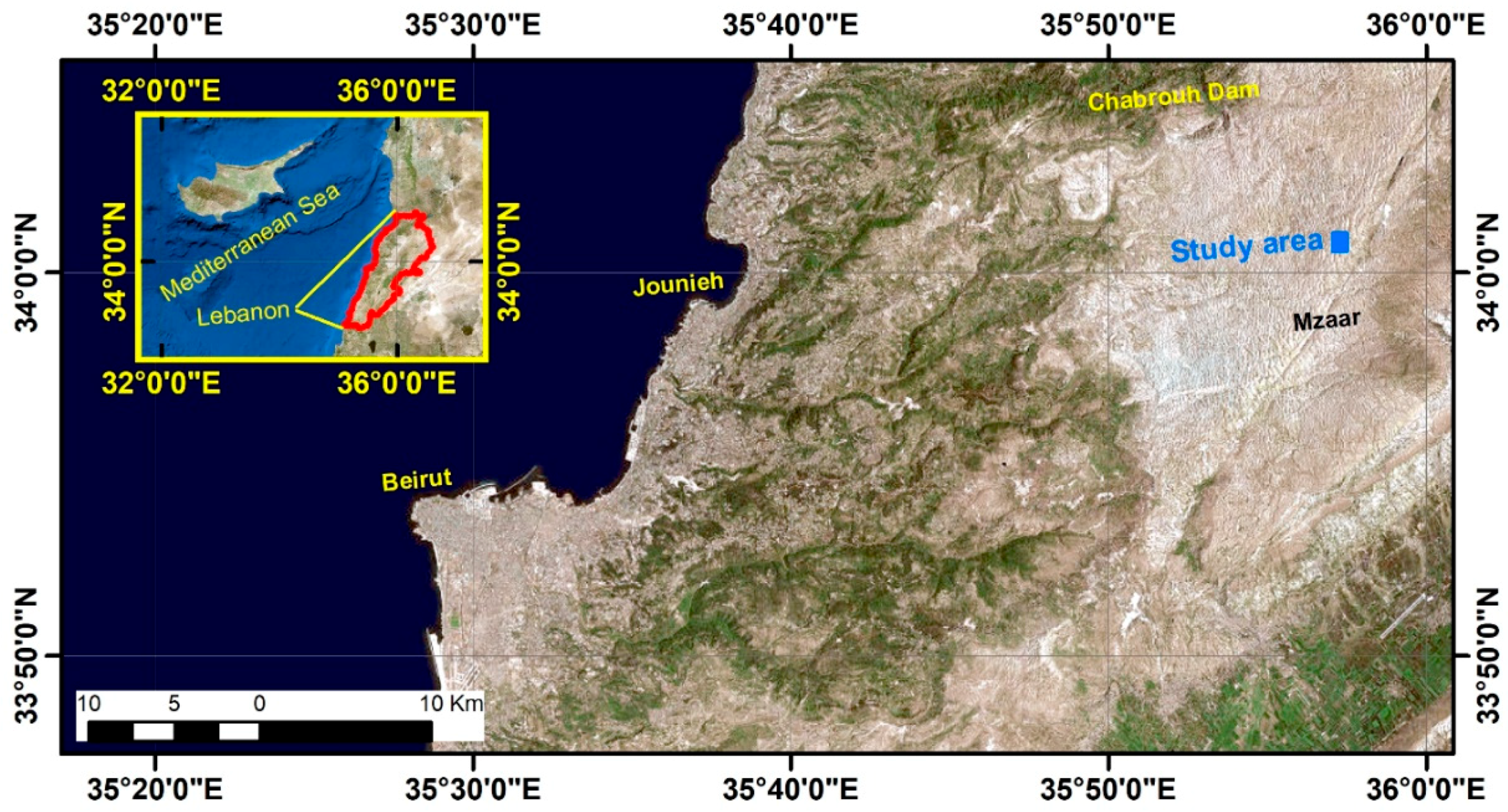
2. Study Area
3. Method
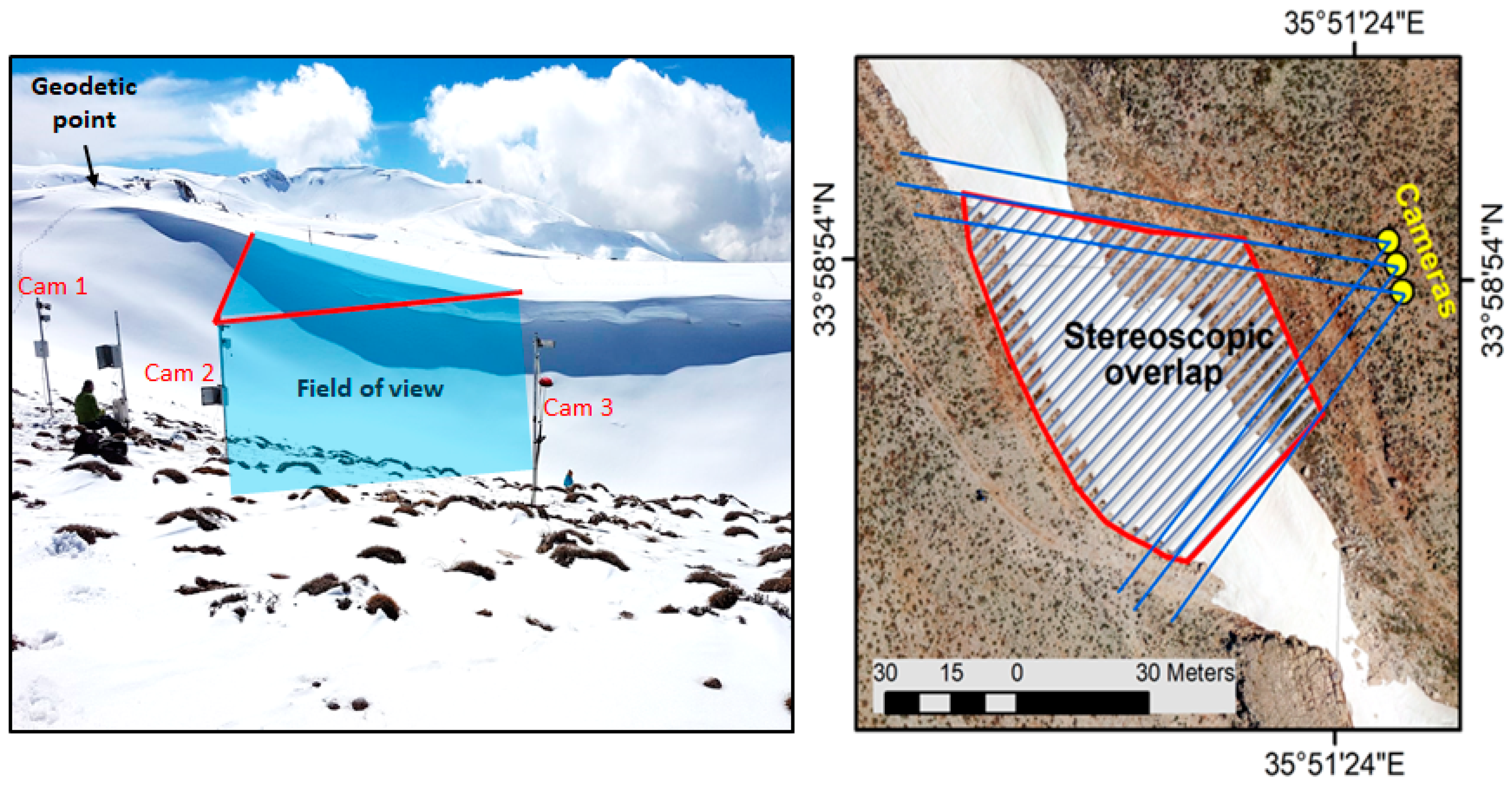
3.1. System Setup
3.2. Photogrammetric Processing
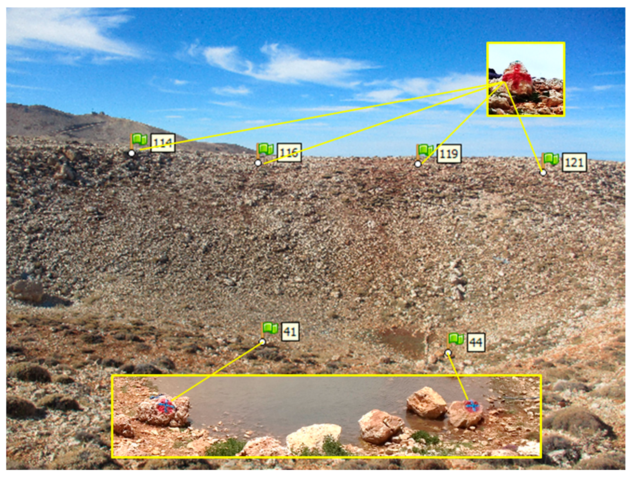
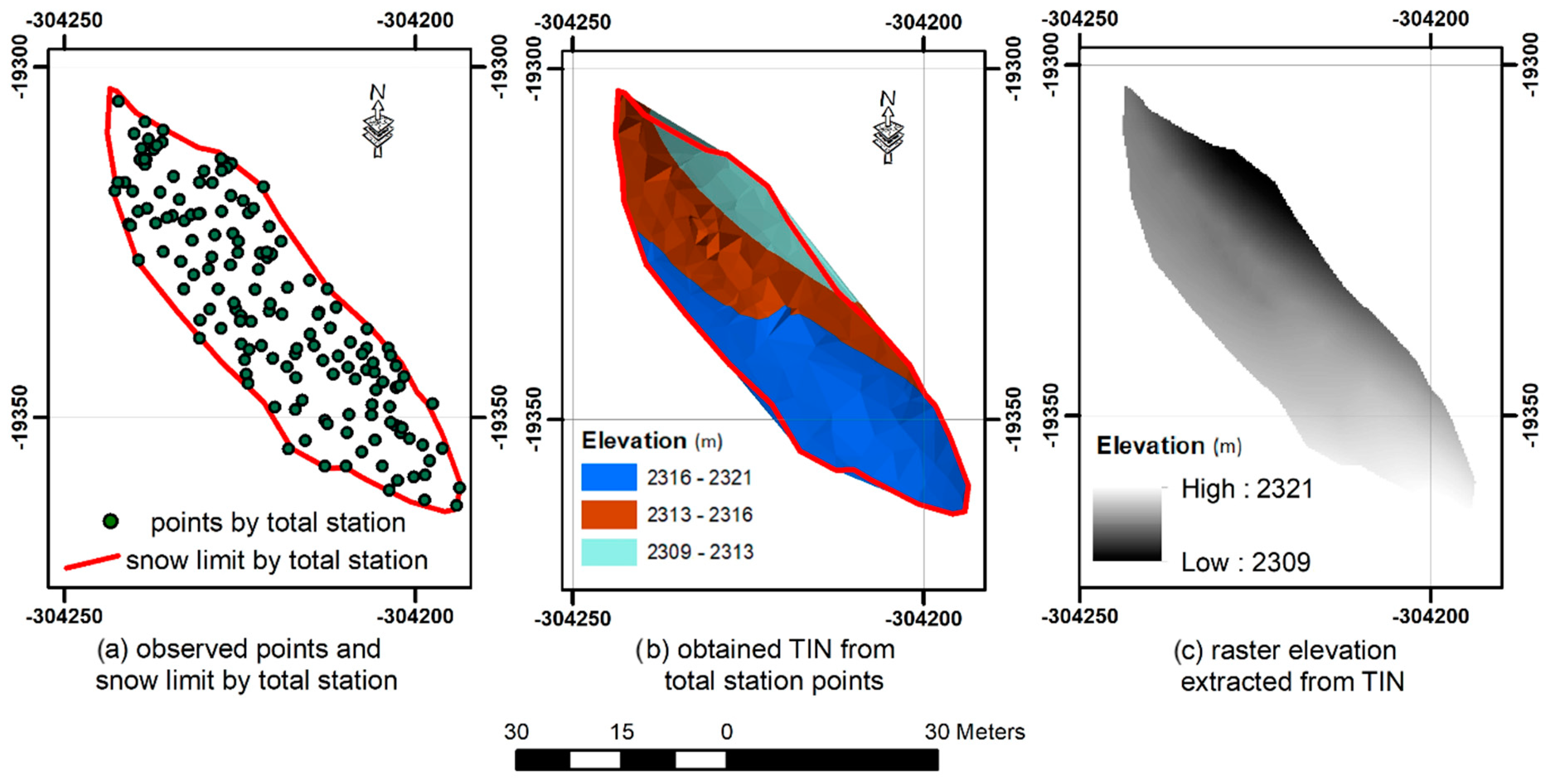
3.3. Ground Truth Measurements
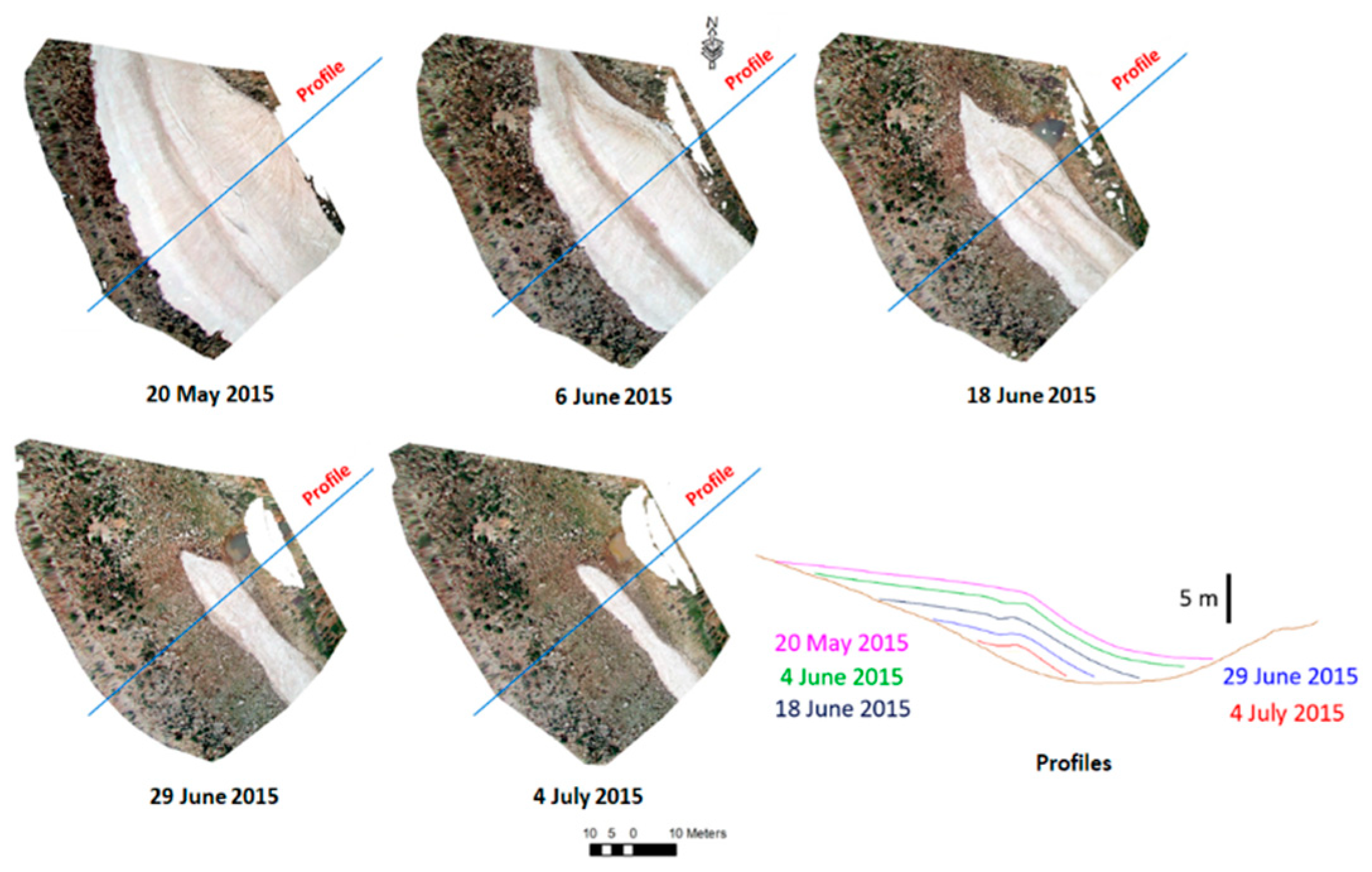
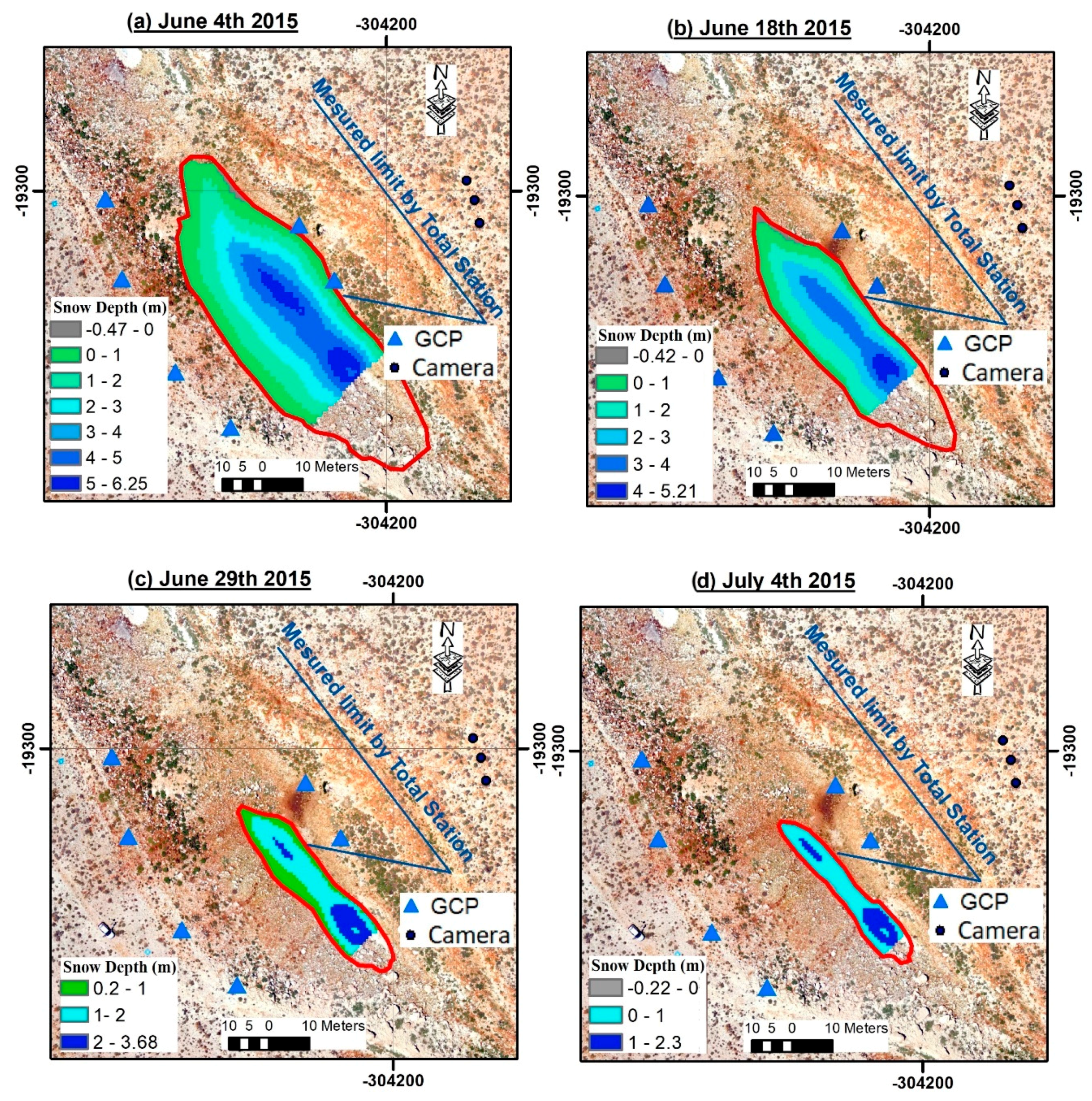
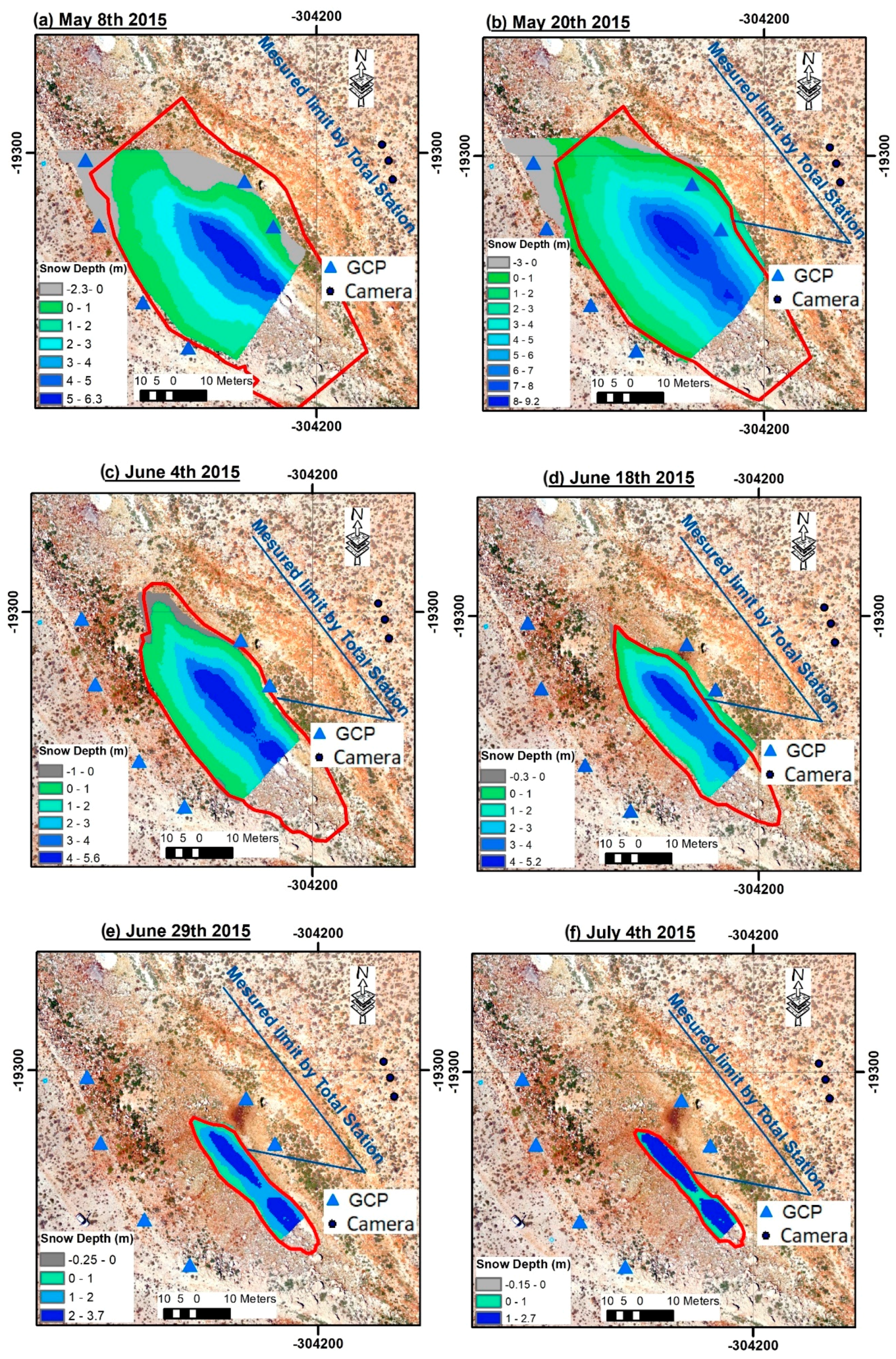
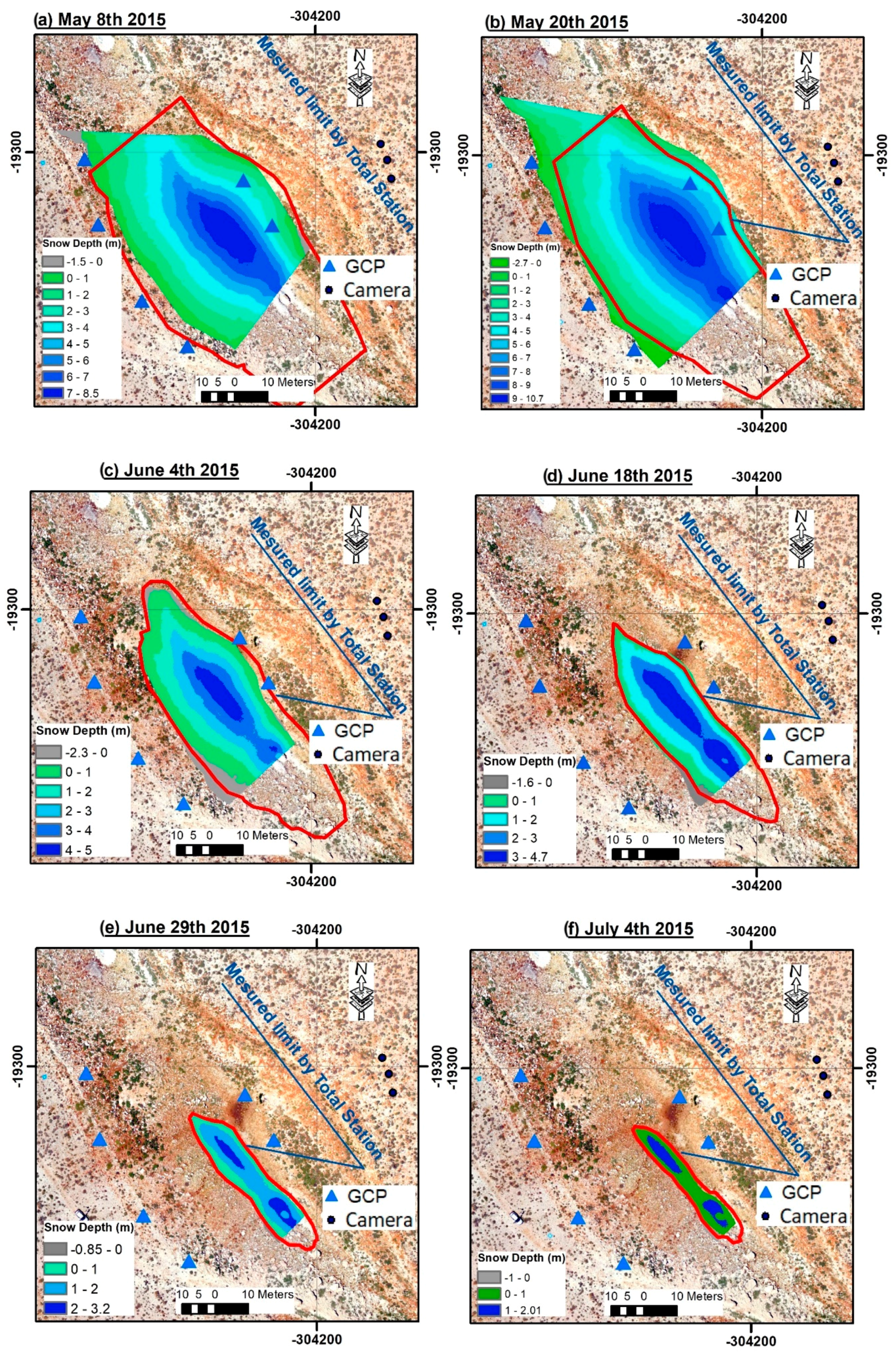
4. Results
5. Discussion
6. Conclusions
Author Contributions
Funding
Acknowledgments
Conflicts of Interest
Appendix A


References
- Baylouny, A.M.; Klingseis, S.J. Water thieves or Political catalysts? syrian refugees in Jordan and Lebanon. Middle east Policy 2018, 25, 104–123. [Google Scholar] [CrossRef]
- Shaban, A.; Faour, G.; Khawlie, M.; Abdallah, C. Remote sensing application to estimate the volume of water in the form of snow on Mount Lebanon/Application de la télédétection à l’estimation du volume d’eau sous forme de neige sur le Mont Liban. Hydrol. Sci. J. 2004, 49, 37–41. [Google Scholar] [CrossRef]
- Shaban, A.; Dariwich, T. Investigating snow characteristics on mountain chains of Lebanon. In Proceedings of the First CIGR Inter-regional Conference on Land and Water Challenges, Bari, Italy, 10–14 September 2013. [Google Scholar]
- Telesca, L.; Shaban, A.; Gascoin, S.; Darwich, T.; Drapeau, L.; El Hage, M.; Faour, G. Characterization of the time dynamics of monthly satellite snow cover data on Mountain Chains in Lebanon. J. Hydrol. 2014, 519, 3214–3222. [Google Scholar] [CrossRef]
- Mhawej, M.; Faour, G.; Fayad, A.; Shaban, A. Towards an enhanced method to map snow cover areas and derive snow-water equivalent in Lebanon. J. Hydrol. 2014, 513, 274–282. [Google Scholar] [CrossRef]
- Somma, J.; Drapeau, L.; Abou Chakra, C. Caractérisation de la capacité de rétention de neige d’un plateau karstique. Essai méthodologique pour le plateau du Jabal Jraid (Liban). Revue internationale de géomatique 2014, 24, 87–99. [Google Scholar] [CrossRef]
- Fayad, A.; Gascoin, S.; Faour, G.; Fanise, P.; Drapeau, L.; Somma, J.; Fadel, A.; Al Bitar, A.; Escadafal, R. Snow observations in Mount Lebanon (2011–2016). Earth Syst. Sci. Data 2017, 9, 573–587. [Google Scholar] [CrossRef]
- Dubertret, L. Carte Géologique du Liban. Available online: https://www.worldcat.org/title/carte-geologique-du-liban/oclc/21747724 (accessed on 9 September 2019).
- Edgell, H.S. Karst and hydrogeology of Lebanon. Carbonates Evaporites 1997, 12, 220. [Google Scholar] [CrossRef]
- Fayad, A.; Gascoin, S.; Faour, G.; López-Moreno, J.I.; Drapeau, L.; Le Page, M.; Escadafal, R. Snow hydrology in Mediterranean mountain regions: A review. J. Hydrol. 2017, 551, 374–396. [Google Scholar] [CrossRef]
- Jonas, T.; Marty, C.; Magnusson, J. Estimating the snow water equivalent from snow depth measurements in the Swiss Alps. J. Hydrol. 2009, 378, 161–167. [Google Scholar] [CrossRef]
- López-Moreno, J.I.; Fassnacht, S.R.; Heath, J.T.; Musselman, K.N.; Revuelto, J.; Latron, J.; Morán-Tejeda, E.; Jonas, T. Small scale spatial variability of snow density and depth over complex alpine terrain: Implications for estimating snow water equivalent. Adv. Water Resour. 2013, 55, 40–52. [Google Scholar] [CrossRef]
- Sturm, M.; Taras, B.; Liston, G.E.; Derksen, C.; Jonas, T.; Lea, J.; Sturm, M.; Taras, B.; Liston, G.E.; Derksen, C.; et al. Estimating Snow Water Equivalent Using Snow Depth Data and Climate Classes. J. Hydrol. 2010, 11, 1380–1394. [Google Scholar] [CrossRef]
- Bühler, Y.; Adams, M.S.; Bösch, R.; Stoffel, A. Mapping snow depth in alpine terrain with unmanned aerial systems (UASs): Potential and limitations. Cryosphere 2016, 10, 1075–1088. [Google Scholar] [CrossRef]
- Marti, R.; Gascoin, S.; Berthier, E.; De Pinel, M.; Houet, T.; Laffly, D. Mapping snow depth in open alpine terrain from stereo satellite imagery. Cryosphere 2016, 10, 1361–1380. [Google Scholar] [CrossRef]
- Deems, J.S.; Painter, T.H.; Finnegan, D.C. Lidar measurement of snow depth: A review. J. Glaciol. 2013, 59, 467–479. [Google Scholar] [CrossRef]
- Garvelmann, J.; Pohl, S.; Weiler, M. From observation to the quantification of snow processes with a time-lapse camera network. Hydrol. Earth Syst. Sci. 2013, 17, 1415–1429. [Google Scholar] [CrossRef]
- Lui, J.; Chen, R.; Wang, G. Snowline and snow cover monitoring at high spatial resolution in a mountainous river basin based on a time-lapse camera at a daily scale. J. Mt Sci. 2015, 12, 60–69. [Google Scholar]
- Kępski, D.; Luks, B.; Migała, K.; Wawrzyniak, T.; Westermann, S.; Wojtuń, B. Terrestrial Remote Sensing of Snowmelt in a Diverse High-Arctic Tundra Environment Using Time-Lapse Imagery. Remote Sens. 2017, 9, 733. [Google Scholar] [CrossRef]
- Parajka, J.; Haas, P.; Kirnbauer, R.; Jansa, J.; Blöschl, G. Potential of time-lapse photography of snow for hydrological purposes at the small catchment scale. Hydrol. Processes 2012, 26, 3327–3337. [Google Scholar] [CrossRef]
- Revuelto, J.; Jonas, T.; López-Moreno, J.I. Backward snow depth reconstruction at high spatial resolution based on time-lapse photography. Hydrol. Processes 2016, 30, 2976–2990. [Google Scholar] [CrossRef]
- Westoby, M.J.; Brasington, J.; Glasser, N.F.; Hambrey, M.J.; Reynolds, J.M. ‘Structure-from-Motion’ photogrammetry: A low-cost, effective tool for geoscience applications. Geomorphology 2012, 179, 300–314. [Google Scholar] [CrossRef]
- Fonstad, M.A.; Dietrich, J.T.; Courville, B.C.; Jensen, J.L.; Carbonneau, P.E. Topographic structure from motion: A new development in photogrammetric measurement. Earth Surf. Processes Landforms 2013, 38, 421–430. [Google Scholar] [CrossRef]
- Micheletti, N.; Chandler, J.H.; Lane, S.N. Structure from Motion (SfM) Photogrammetry. In Geomorphological Techniques (Online Edition); Clarke, L.E., Nield, J.M., Eds.; British Society for Geomorphology: London, UK, 2015; Chap. 2. [Google Scholar]
- Morgan, J.A.; Brogan, D.J.; Nelson, P.A. Application of Structure-from-Motion photogrammetry in laboratory flumes. Geomorphology 2017, 276, 125–143. [Google Scholar] [CrossRef]
- Balaguer-Puig, M.; Marqués-Mateu, Á.; Lerma, J.L.; Ibáñez-Asensio, S. Estimation of small-scale soil erosion in laboratory experiments with Structure from Motion photogrammetry. Geomorphology 2017, 295, 285–296. [Google Scholar] [CrossRef]
- Mertes, J.R.; Gulley, J.D.; Benn, D.I.; Thompson, S.S.; Nicholson, L.I. Using structure-from-motion to create glacier DEMs and orthoimagery from historical terrestrial and oblique aerial imagery. Earth Surf. Processes Landforms 2017, 42, 2350–2364. [Google Scholar] [CrossRef]
- Cimoli, E. Determining Snow Depth Distribution from Unmanned Aerial Vehicles and Digital Photogrammetry. Master’s Thesis, Technical University of Denmark, Kongens Lyngby, Denmark, August 2015. [Google Scholar]
- Brunier, G.; Fleury, J.; Anthony, E.J.; Gardel, A.; Dussouillez, P. Close-range airborne Structure-from-Motion Photogrammetry for high-resolution beach morphometric surveys: Examples from an embayed rotating beach. Geomorphology 2016, 261, 76–88. [Google Scholar] [CrossRef]
- Gindraux, S.; Boesch, R.; Farinotti, D. Accuracy assessment of digital surface models from Unmanned Aerial Vehicles’ imagery on glaciers. Remote Sens. 2017, 9, 186. [Google Scholar] [CrossRef]
- Nissen, E.; Krishnan, A.K.; Arrowsmith, J.R.; Saripalli, S. Three-dimensional surface displacements and rotations from differencing pre-and post-earthquake LiDAR point clouds. Geophys. Res. Lett. 2012, 39, 1–6. [Google Scholar] [CrossRef]
- He, Y.; Liang, B.; Yang, J.; Li, S.; He, J. An Iterative Closest Points Algorithm for Registration of 3D Laser Scanner Point Clouds with Geometric Features. Sensors 2017, 17, 1862. [Google Scholar] [CrossRef]
- Teza, G.; Galgaro, A.; Zaltron, N.; Genevois, R. Terrestrial laser scanner to detect landslide displacement fields: A new approach. Int. J. Remote Sens. 2007, 28, 3425–3446. [Google Scholar] [CrossRef]
- Shean, D.; Alexandrov, O.; Moratto, Z.; Smith, B.; Joughin, I. An automated, open-source pipeline for mass production of digital elevation models (DEMs) from very-high-resolution commercial stereo satellite imagery. ISPRS J. Photogramm. Remote Sens. 2016, 116, 101–117. [Google Scholar] [CrossRef]
- Lavine, A.; Gardner, J.N.; Reneau, S.L. Total station geologic mapping: An innovative approach to analyzing surface-faulting hazards. Eng. Geol. 2003, 70, 71–91. [Google Scholar] [CrossRef]
- Wolf, D.G.P.R. Elementary Surveying; Pearson: Essex, UK, 2014. [Google Scholar]
- Jaud, M.; Passot, S.; Le Bivic, R.; Delacourt, C.; Grandjean, P.; Le Dantec, N. Assessing the accuracy of high resolution digital surface models computed by PhotoScan® and MicMac® in sub-optimal survey conditions. Remote Sens. 2016, 8, 465. [Google Scholar] [CrossRef]


| Snow-off DEM Source Imagery | Snow-on DEM Source Imagery | Method to Register Snow-on DEM | |
|---|---|---|---|
| Exp. 1 | cameras | cameras | GCP |
| Exp. 2 | cameras | cameras | ICP |
| Exp. 3 | drone | cameras | ICP |
| Date | Number of Points |
|---|---|
| 8 May 2019 | 210 |
| 20 May 2019 | 250 |
| 4 June 2019 | 219 |
| 18 June 2019 | 140 |
| 29 June 2019 | 168 |
| 4 July 2019 | 92 |
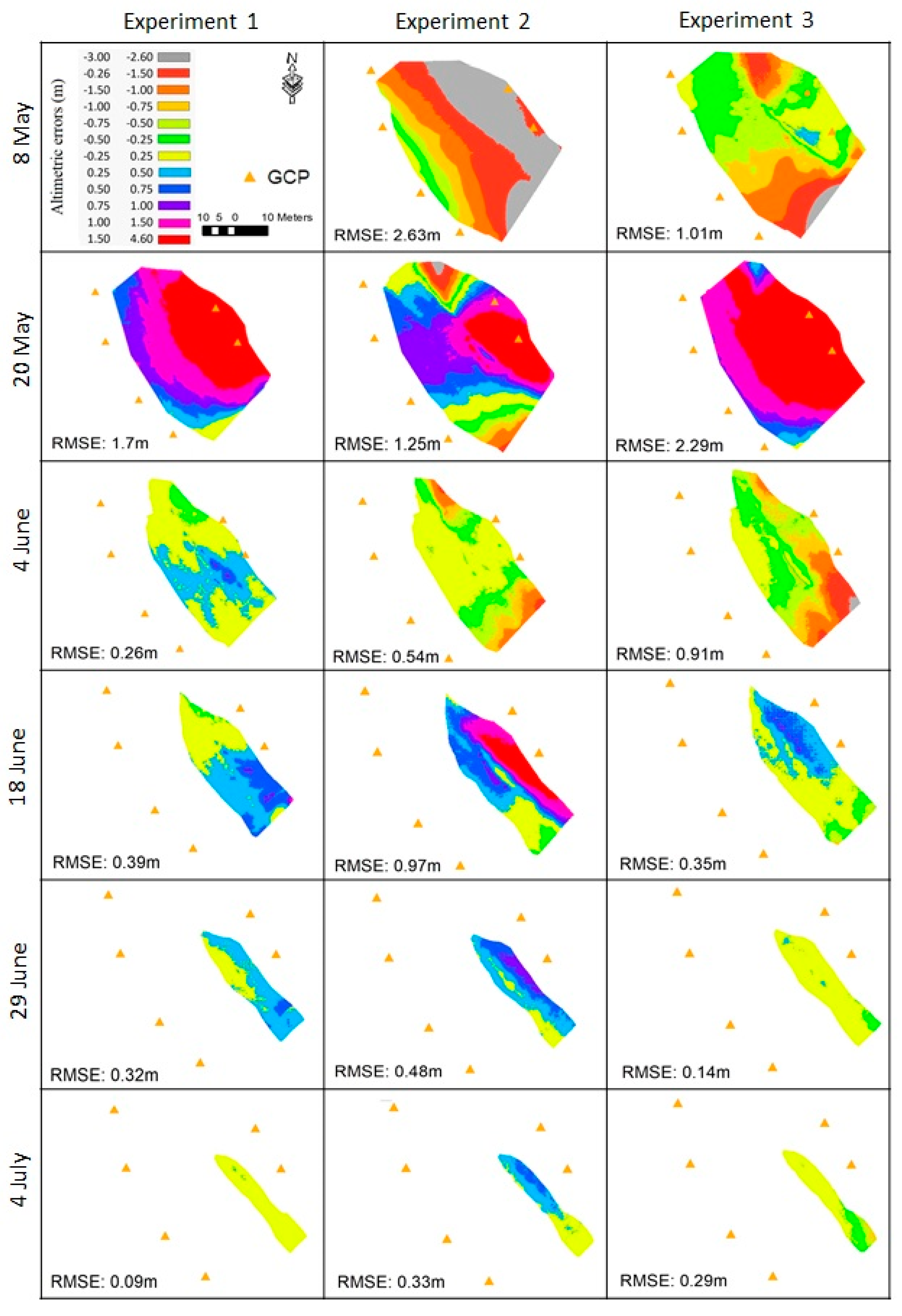
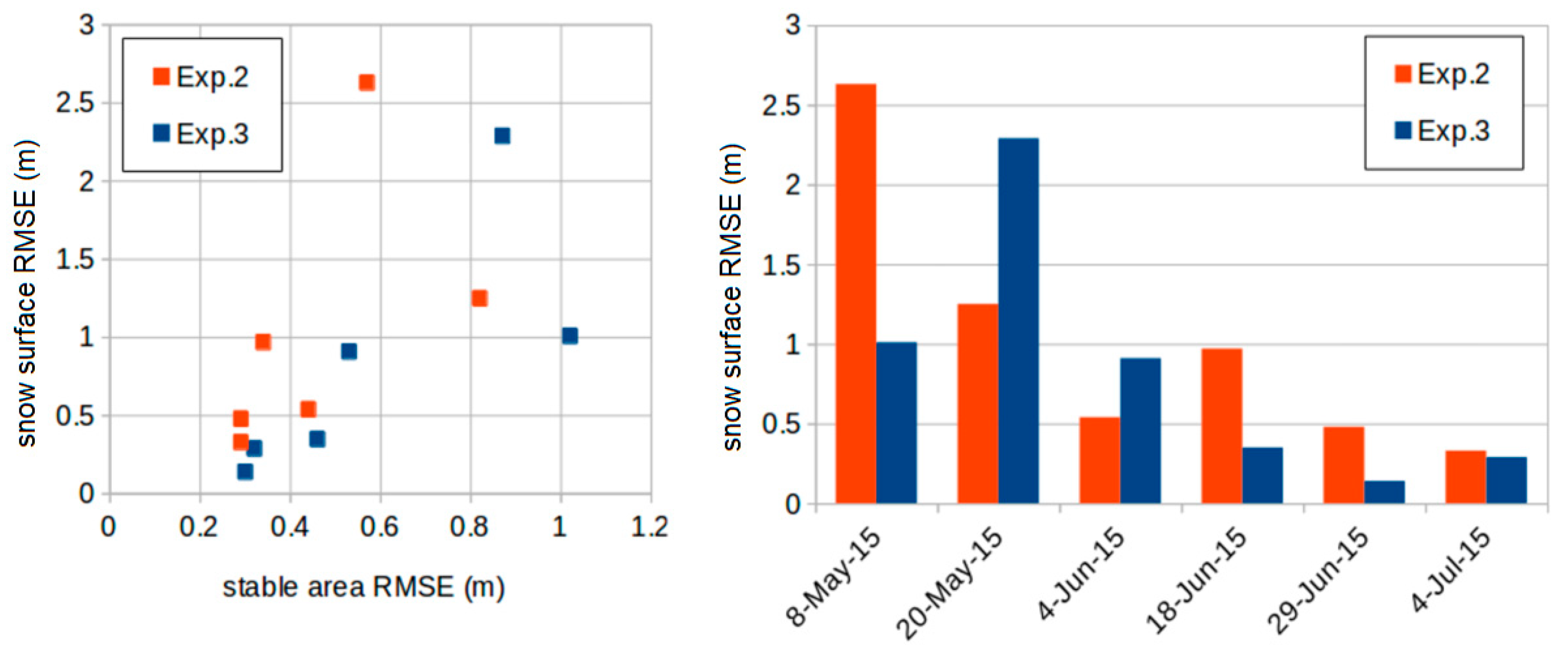
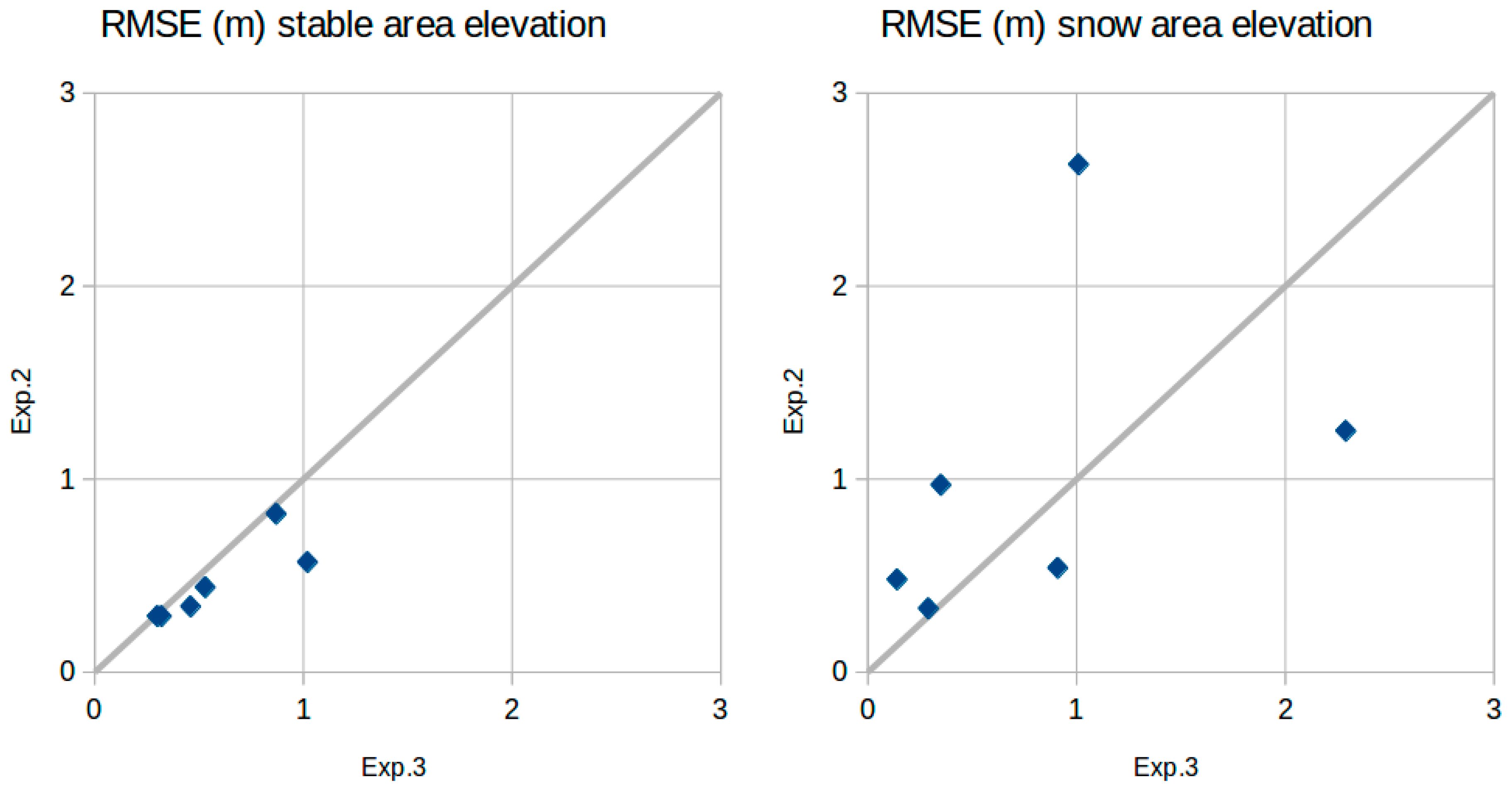
| Date | Exp. | Min (m) | Max (m) | Mean (m) | Std (m) | RMSE (m) | Stable Area RMSE (m) |
|---|---|---|---|---|---|---|---|
| 8-May-2015 | 1 | N/A | N/A | N/A | N/A | N/A | N/A |
| 2 | −6.78 | 0.09 | −2.23 | 1.40 | 2.63 | 0.57 | |
| 3 | −3.32 | 0.53 | −0.79 | 0.63 | 1.01 | 1.02 | |
| 20-May-2015 | 1 | −0.21 | 3.39 | 1.50 | 0.81 | 1.70 | |
| 2 | −3.10 | 3.35 | 0.66 | 1.06 | 1.25 | 0.82 | |
| 3 | −0.06 | 4.45 | 2.05 | 1.03 | 2.29 | 0.87 | |
| 4-Jun-2015 | 1 | −0.57 | 0.81 | 0.17 | 0.20 | 0.26 | |
| 2 | −1.86 | 0.32 | −0.35 | 0.41 | 0.54 | 0.44 | |
| 3 | −3.12 | 0.11 | −0.73 | 0.54 | 0.91 | 0.53 | |
| 18-June-2015 | 1 | −0.46 | 1.44 | 0.28 | 0.27 | 0.39 | |
| 2 | −0.54 | 2.2 | 0.74 | 0.63 | 0.97 | 0.34 | |
| 3 | −0.94 | 1.00 | 0.17 | 0.31 | 0.35 | 0.46 | |
| 29-June-2015 | 1 | −0.03 | 0.77 | 0.30 | 0.12 | 0.32 | |
| 2 | −0.10 | 0.91 | 0.43 | 0.21 | 0.48 | 0.29 | |
| 3 | −0.48 | 0.33 | 0.02 | 0.14 | 0.14 | 0.30 | |
| 4-July-2015 | 1 | −0.18 | 0.33 | 0.03 | 0.08 | 0.09 | |
| 2 | −0.22 | 0.68 | 0.27 | 0.19 | 0.33 | 0.29 | |
| 3 | −0.96 | 0.27 | −0.15 | 0.25 | 0.29 | 0.32 |
© 2019 by the authors. Licensee MDPI, Basel, Switzerland. This article is an open access article distributed under the terms and conditions of the Creative Commons Attribution (CC BY) license (http://creativecommons.org/licenses/by/4.0/).
Share and Cite
Chakra, C.A.; Gascoin, S.; Somma, J.; Fanise, P.; Drapeau, L. Monitoring the Snowpack Volume in a Sinkhole on Mount Lebanon using Time Lapse Photogrammetry. Sensors 2019, 19, 3890. https://doi.org/10.3390/s19183890
Chakra CA, Gascoin S, Somma J, Fanise P, Drapeau L. Monitoring the Snowpack Volume in a Sinkhole on Mount Lebanon using Time Lapse Photogrammetry. Sensors. 2019; 19(18):3890. https://doi.org/10.3390/s19183890
Chicago/Turabian StyleChakra, Charbel Abou, Simon Gascoin, Janine Somma, Pascal Fanise, and Laurent Drapeau. 2019. "Monitoring the Snowpack Volume in a Sinkhole on Mount Lebanon using Time Lapse Photogrammetry" Sensors 19, no. 18: 3890. https://doi.org/10.3390/s19183890
APA StyleChakra, C. A., Gascoin, S., Somma, J., Fanise, P., & Drapeau, L. (2019). Monitoring the Snowpack Volume in a Sinkhole on Mount Lebanon using Time Lapse Photogrammetry. Sensors, 19(18), 3890. https://doi.org/10.3390/s19183890