Recent Surface Water Extent of Lake Chad from Multispectral Sensors and GRACE


Abstract
1. Introduction
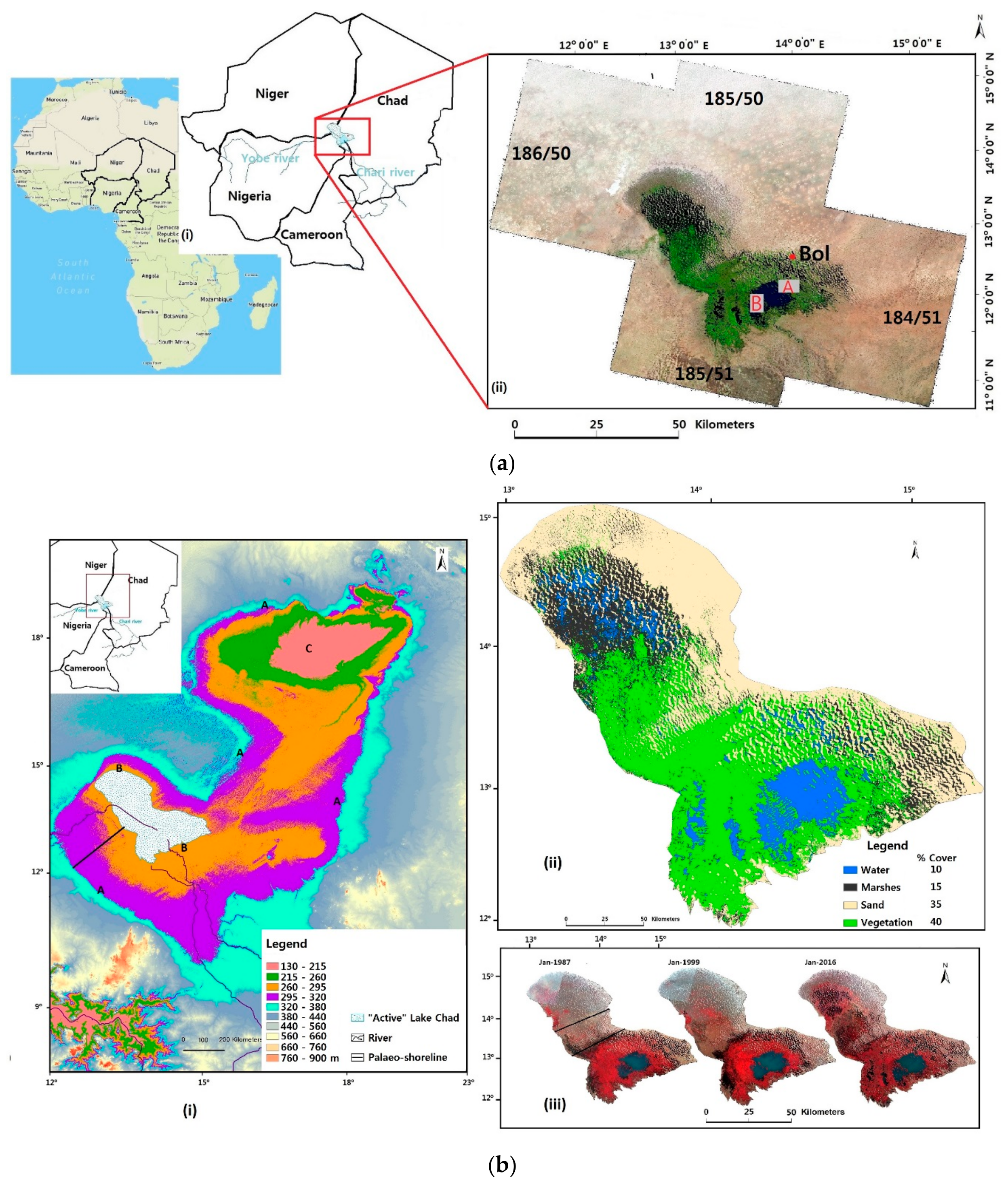
2. Study Area
3. Materials
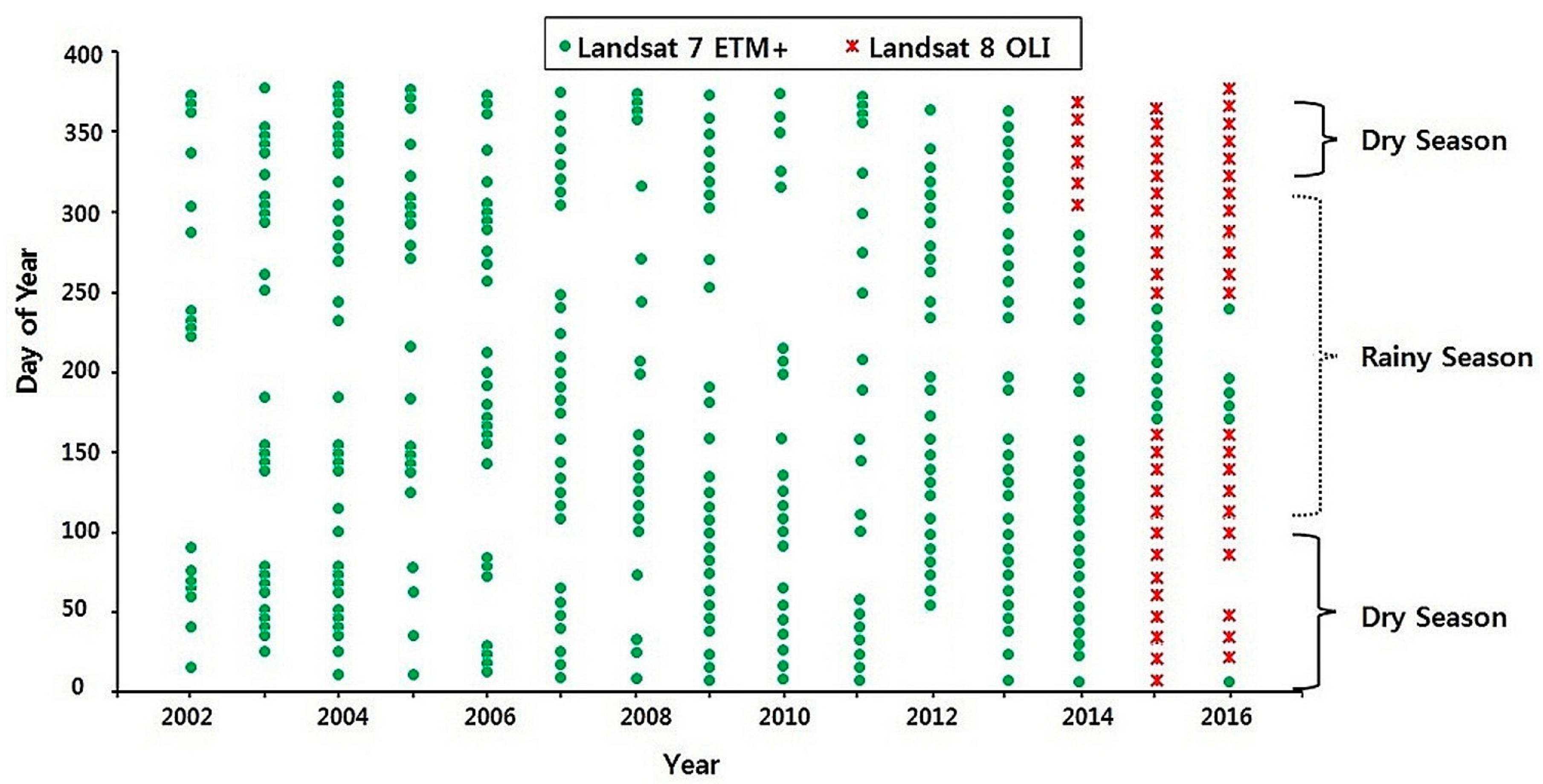
3.1. Landsat Imagery
3.2. GRACE TWSA
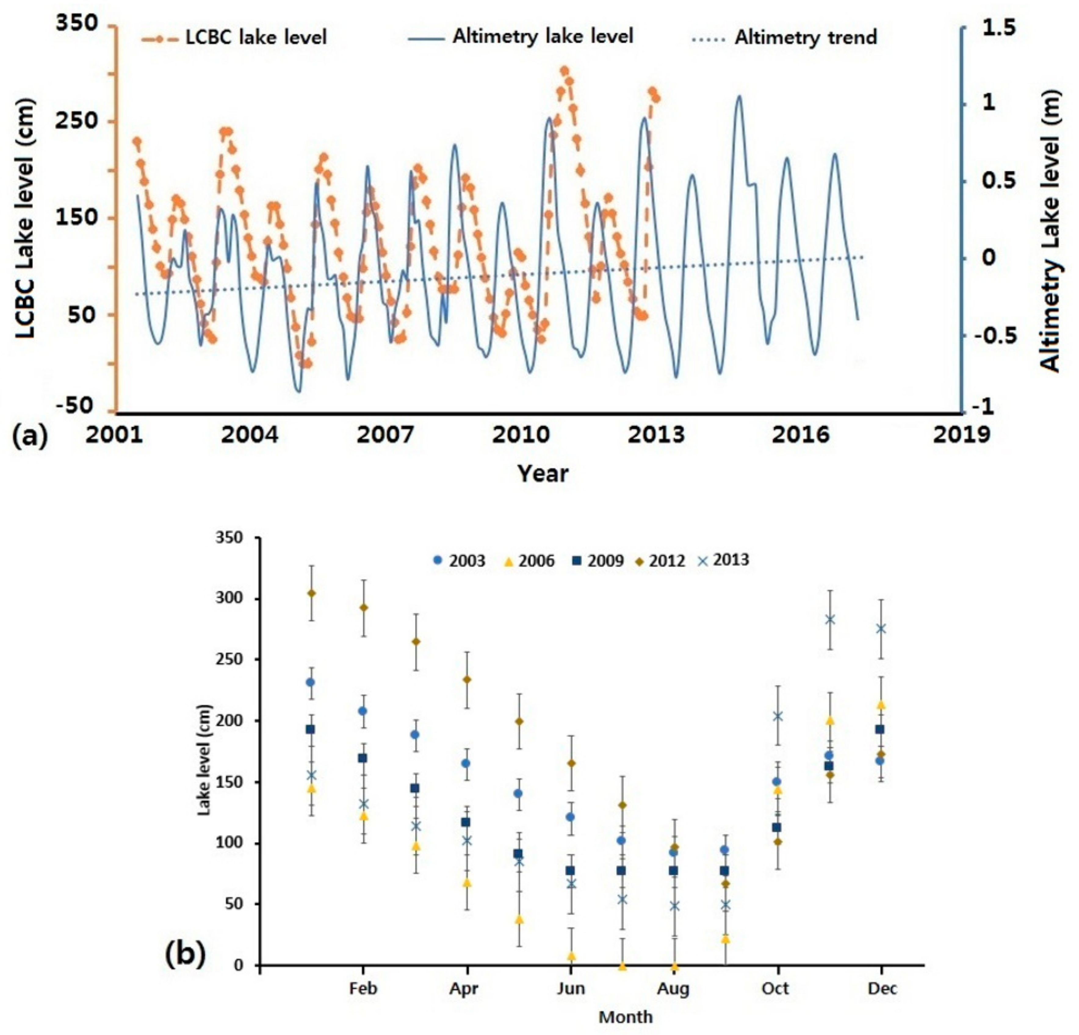
3.3. Rainfall and Lake Level Data
4. Methods
4.1. Pre-Processing
4.2. Processing
4.3. Performance Evaluation
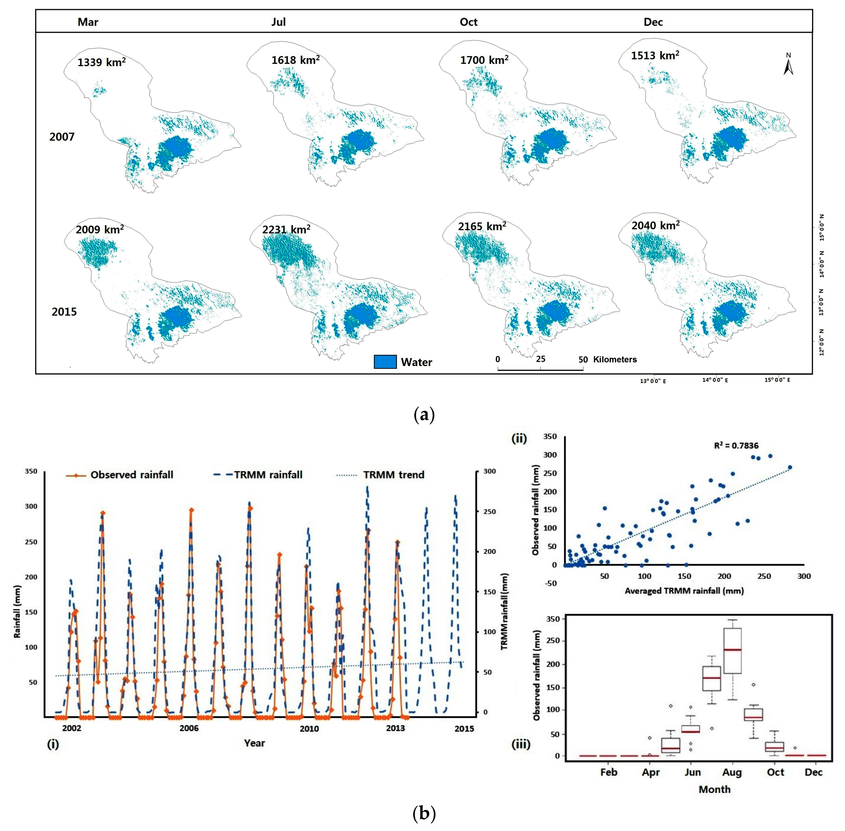
5. Results
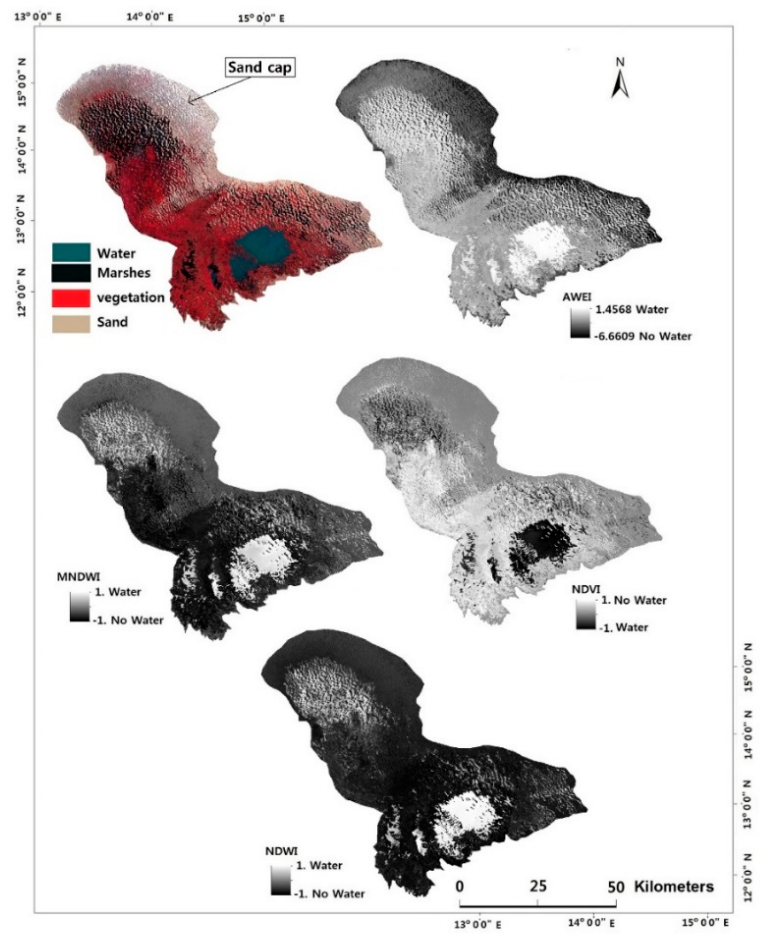
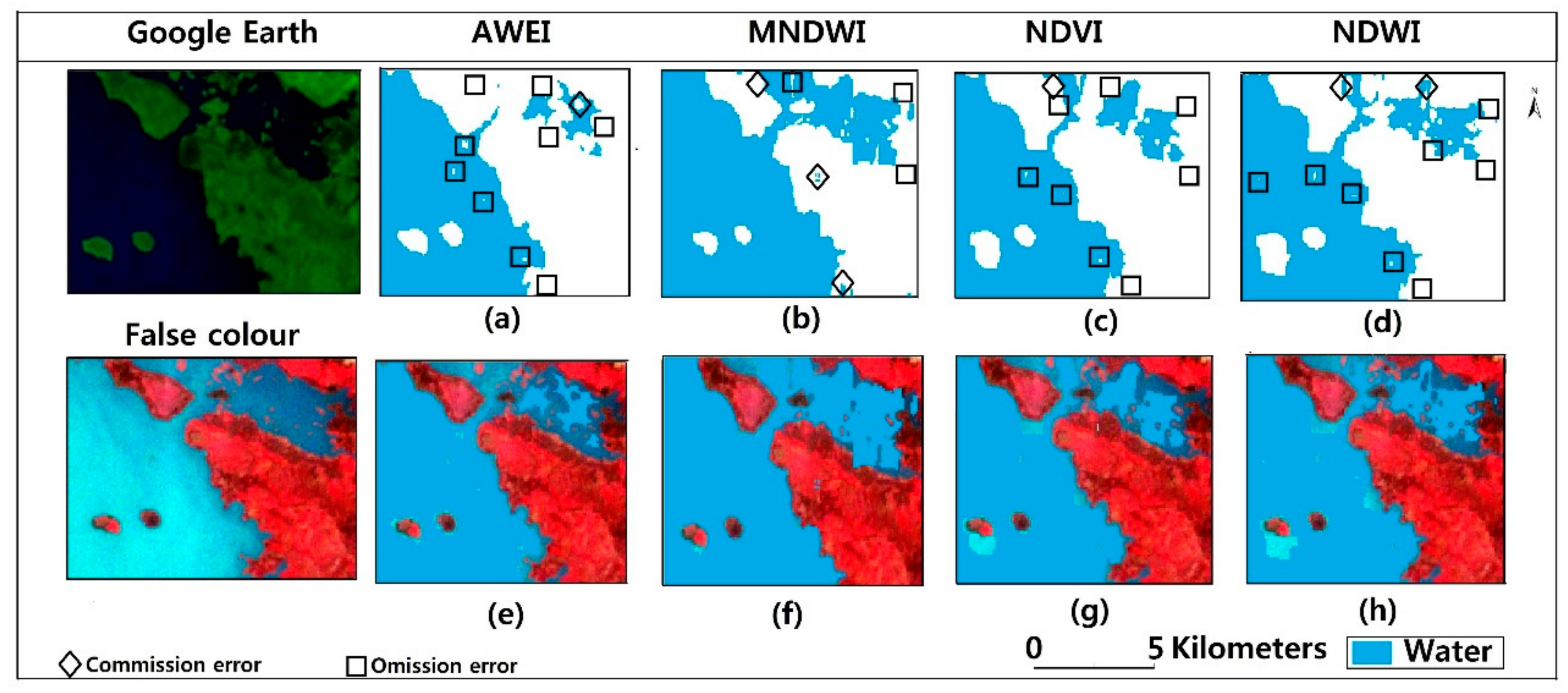
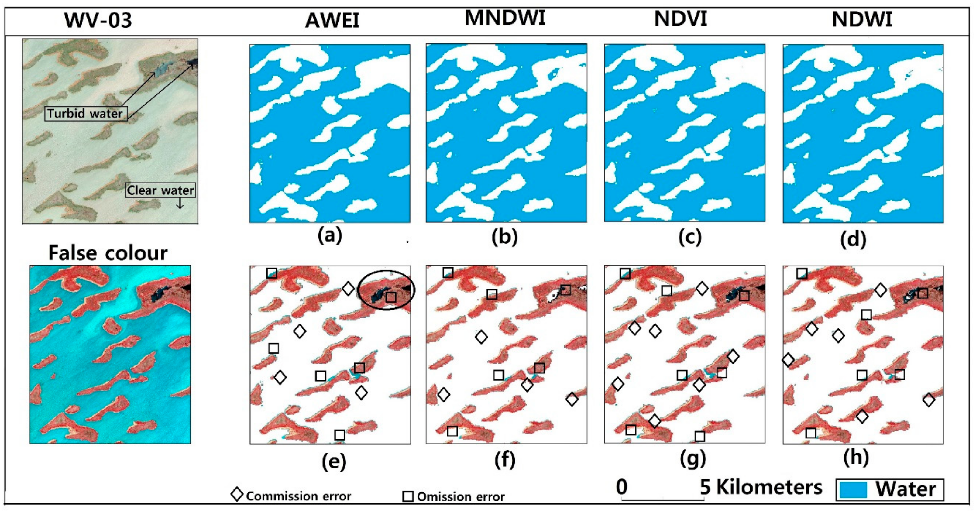
5.1. Performance Evaluation of AWEI, MNDWI, NDVI and NDWI
5.2. Lake Surface Water Extraction
5.2.1. Water Extraction Accuracy
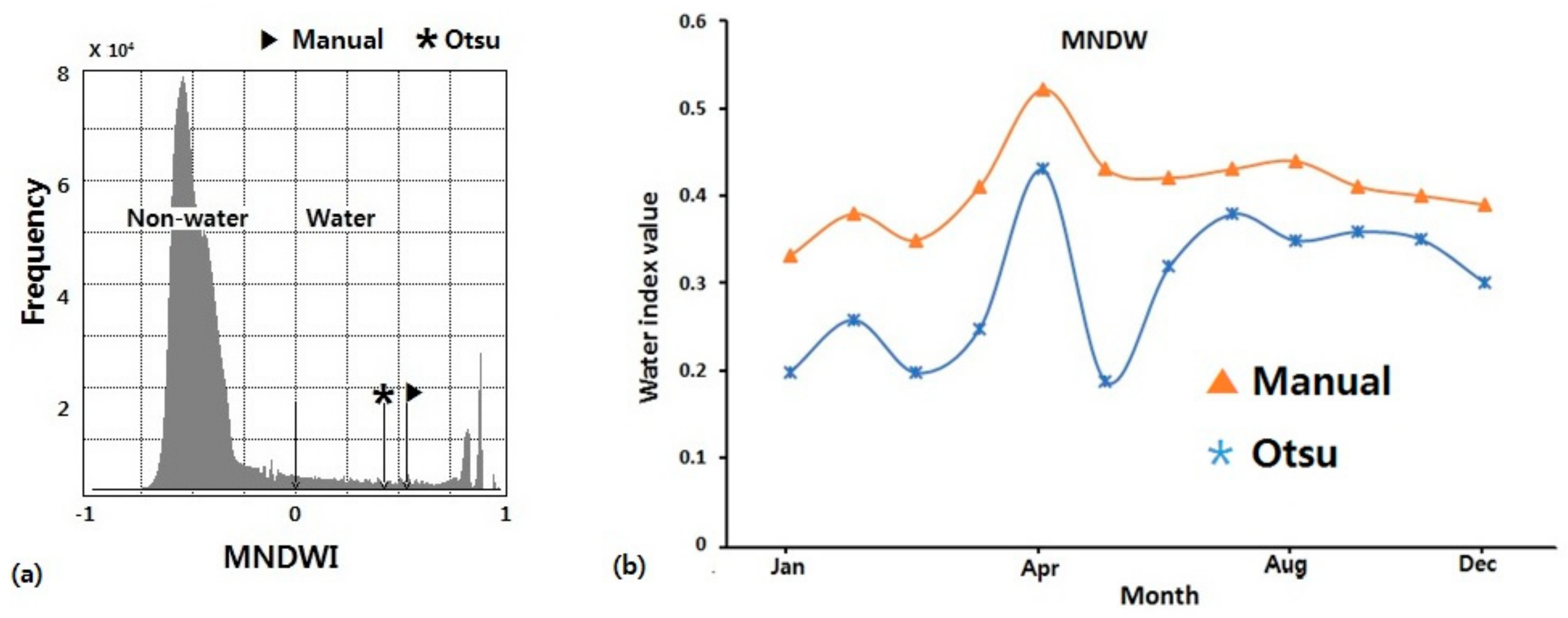
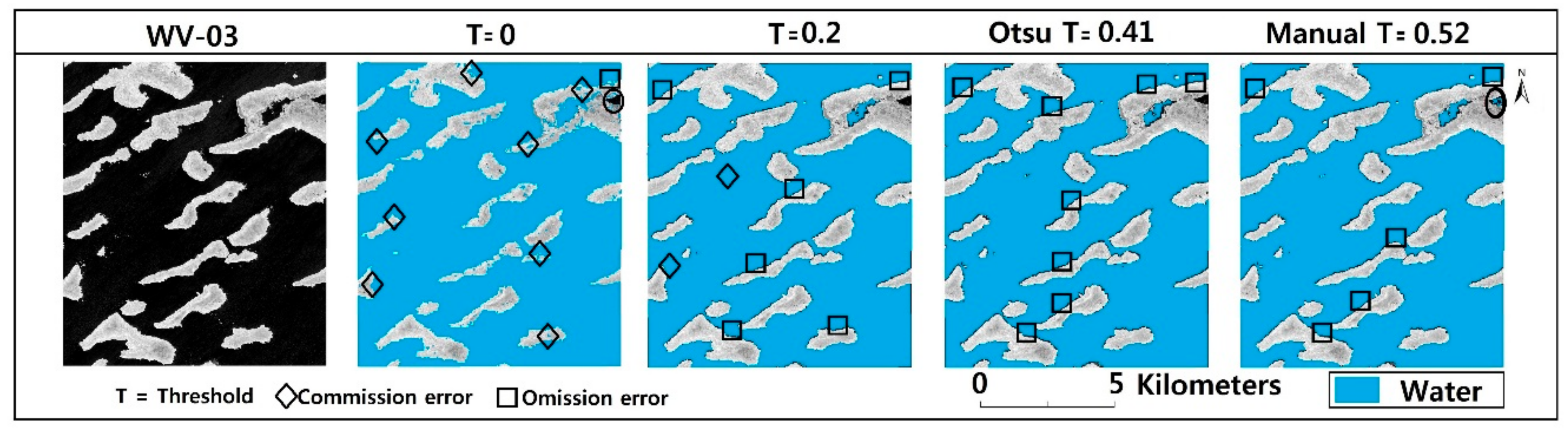
5.2.2. Optimal Threshold for MNDWI
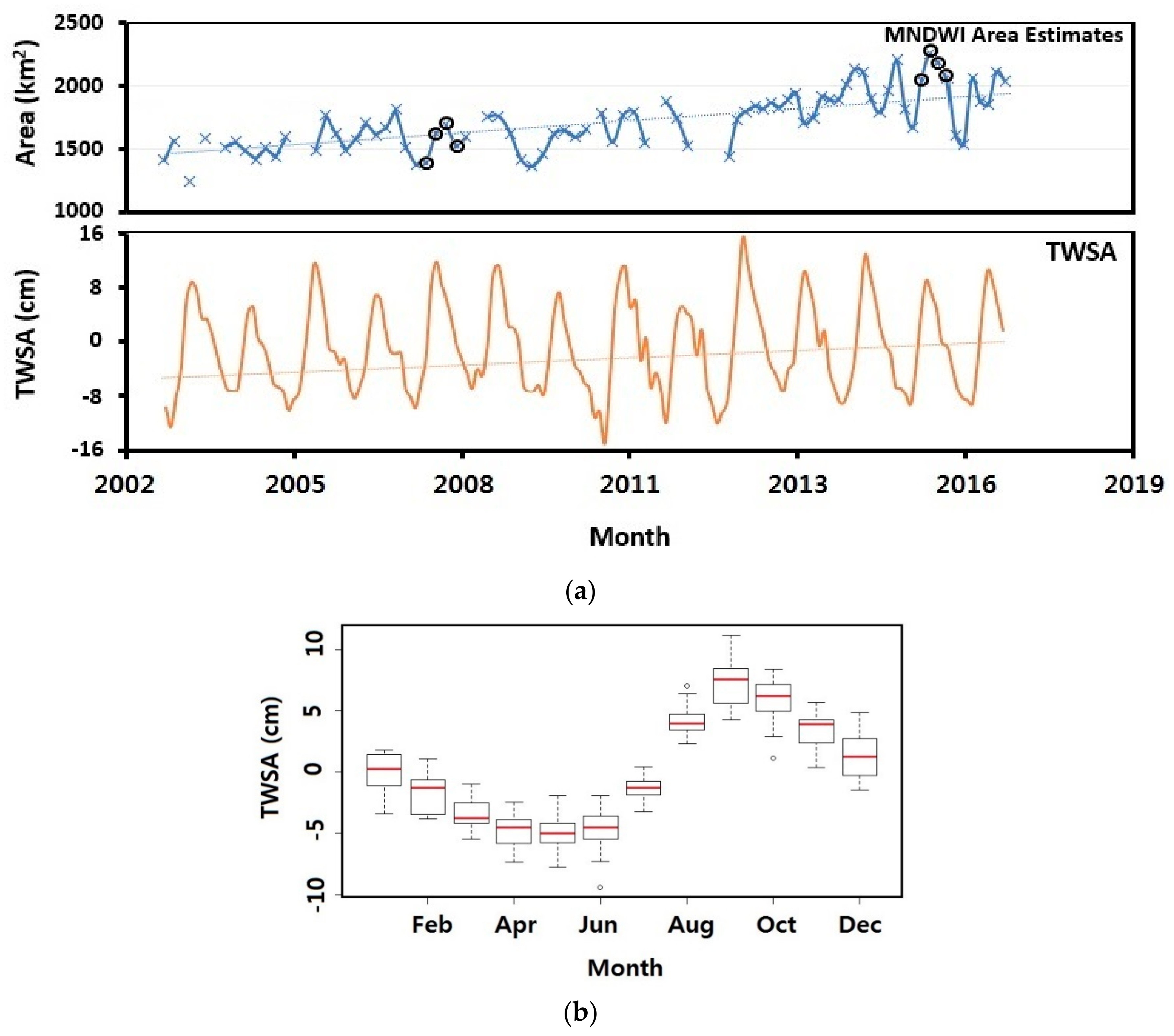
5.3. GRACE-TWSA: An Integrative Indicator of Lake Chad Hydrological Dynamics
6. Discussion
6.1. Threshold Analysis
6.2. Estimated Area and Surface Changes
6.3. Error Analysis
7. Conclusions
Author Contributions
Funding
Acknowledgments
Conflicts of Interest
References
- Charles, J.V. Millennium Ecosystem Assessment. In Ecosystems and Human Well-Being: Current State and Trends; Island Press: Washington, DC, USA, 2005; Volume 1, Chapter 7; pp. 165–207. [Google Scholar]
- Moss, B. Cogs in the endless machine: Lakes, climate change and nutrient cycles: A review. Sci. Total Environ. 2012, 434, 130–142. [Google Scholar] [CrossRef] [PubMed]
- Stendera, S.; Adrian, R.; Bonada, N.; Cañedo Argüelles, M.; Hugueny, B.; Januschke, K.; Pletterbauer, F.; Hering, D. Drivers and stressors of freshwater biodiversity patterns across different ecosystems and scales: A review. Hydrobiologia 2012, 696, 1–28. [Google Scholar] [CrossRef]
- Carvalho, L.; McDonald, C.; de Hoyos, C.; Mischke, U.; Phillips, G.; Borics, G.; Poikane, S.; Skjelbred, B.; Solheim, A.L.; van Wichelen, J.; et al. Sustaining recreational quality of European lakes: Minimizing the health risks from algal blooms through phosphorus control. J. Appl. Ecol. 2013, 50, 315–323. [Google Scholar] [CrossRef]
- Adrian, R.; O’Reilly, C.M.; Zagarese, H.; Baines, S.B.; Hessen, D.O.; Keller, W.; Living-stone, D.M.; Sommaruga, R.; Straile, D.; van Donk, E.; et al. Lakes as sentinels of climate change. Limnol. Oceanogr. 2009, 54, 2283–2297. [Google Scholar] [CrossRef] [PubMed]
- Jean-François, P.; Andrew, C.; Noel, G.; Alan, S.B. High-resolution mapping of global surface water and its long-term changes. Nature 2016, 540, 418–422. [Google Scholar] [CrossRef]
- Cole, J.J.; Prairie, Y.T.; Caraco, N.F.; McDowell, W.H.; Tranvik, L.J.; Striegl, R.G.; Duarte, C.M. Plumbing the Global Carbon Cycle: Integrating Inland Waters into the Terrestrial Carbon Budget. Ecosystems 2007, 10, 172–185. [Google Scholar] [CrossRef]
- Craglia, M.; de Bie, K.; Jackson, D.; Pesaresi, M.; Remetey-Fülöpp, G.; Wang, C.; Annoni, A. Digital Earth 2020: Towards the vision for the next decade. Int. J. Digit. Earth 2012, 5, 4–21. [Google Scholar] [CrossRef]
- Haas, E.M.; Bartholomé, E.; Combal, B. Time series analysis of optical remote sensing data for the mapping of temporary surface water bodies in sub-Saharan western Africa. J. Hydrol. 2009, 370, 52–63. [Google Scholar] [CrossRef]
- Novoa, S.; Chust, G.; Sagarminaga, Y.; Revilla, M.; Borja, A.; Franco, J. Water quality assessment using satellite-derived chlorophyll-a within the European directives, in the southeastern Bay of Biscay. Mar. Pollut. Bull. 2012, 64, 739–750. [Google Scholar] [CrossRef] [PubMed]
- Julia, B.; Thomas, G.; Birgit, H.; Frank, G.; Moritz, L.; Sina, M.; Isabelle, G.; Stephan, L. Satellite-derived changes in the permafrost landscape of central Yakutia, 2000–2011: Wetting, drying, and fires. Glob. Planet. Chang. 2016, 139, 116–127. [Google Scholar] [CrossRef]
- Zhang, Z.; Chen, X.; Xu, C.Y.; Hong, Y.; Hardy, J.; Sun, Z. Examining the influence of river-lake interaction on the drought and water resources in the Poyang Lake basin. J. Hydrol. 2015, 522, 510–521. [Google Scholar] [CrossRef]
- Chang, N.B.; Imen, S.; Vannah, B. Remote Sensing for Monitoring Surface Water Quality Status and Ecosystem State in Relation to the Nutrient Cycle: A 40-Year Perspective. Crit. Rev. Environ. Sci. Technol. 2015, 45, 101–166. [Google Scholar] [CrossRef]
- Hanne, J.; Christian, W. Vulnerability to climate change and adaptation strategies of local communities in Malawi: Experiences of women fish-processing groups in the Lake Chilwa Basin. Earth Syst. Dyn. 2016, 7, 977–989. [Google Scholar] [CrossRef]
- Hickmat, H.; Abdelazim, N. Change detection in the water bodies of Burullus Lake, Northern Nile Delta, Egypt, using RS/GIS. Procedia Eng. 2016, 154, 951–958. [Google Scholar] [CrossRef]
- Benjamin, G.; Yaw, M.A.; Eric, T.T.; Eric, K.F. Mapping the spatial changes in Lake Volta using multitemporal remote sensing approach. Lakes and Reservoirs. Lakes Reserv. Res. Manag. 2016, 21, 206–215. [Google Scholar] [CrossRef]
- Lindsey, J.G.; Vermote, E.F.; Saleous, N.; Wolfe, R.; Jan, R. Surface area variability of a North-Central Tanzanian crater lake. Geosciences 2016, 6, 27. [Google Scholar] [CrossRef]
- Masek, J.G.; Vermote, E.F.; Saleous, N.; Wolfe, R.; Hall, F.G.; Huemmrich, F.; Gao, F.; Kutler, J.; Lim, T.K. LEDAPS Landsat Calibration, Reflectance, Atmospheric Correction Preprocessing Code; ORNL DAAC: Oak Ridge, TN, USA, 2012. [Google Scholar] [CrossRef]
- Feng, M.; Sexton, J.O.; Huang, C.; Masek, J.G.; Vermote, F.; Gao, F.; Narasimhan, R.; Channan, S.; Wolfe, R.S.; Townshend, J.R. Global surface reflectance products-from Landsat-Assessment using coincident MODIS observations. Remote Sens. Environ. 2013, 134, 276–293. [Google Scholar] [CrossRef]
- Otukei, J.; Blaschke, T. Land cover change assessment using decision trees, support vector machines and maximum likelihood classification algorithms. Int. J. Appl. Earth Obs. Geoinf. 2010, 12, 27–31. [Google Scholar] [CrossRef]
- Davranche, A.; Lefebvre, G.; Poulin, B. Wetland monitoring using classification trees and SPOT-5 seasonal time series. Remote Sens. Environ. 2010, 114, 552–562. [Google Scholar] [CrossRef]
- Giardino, C.; Bresciani, M.; Villa, P.; Martinelli, A. Application of remote sensing in water resource management: The case study of Lake Trasimeno, Italy. Water Resour. Manag. 2010, 24, 3885–3899. [Google Scholar] [CrossRef]
- Shaohong, T.; Xianfeng, Z.; Jie, T.; Quan, S. Random Forest Classification of Wetland Landcovers from Multi-Sensor Data in the Arid Region of Xinjiang, China. Remote Sens. 2016, 8, 954. [Google Scholar] [CrossRef]
- Rogers, A.S.; Kearney, M.S. Reducing signature variability in unmixing coastal marsh Thematic Mapper scenes using spectral indices. Int. J. Remote Sens. 2004, 25, 2317–2335. [Google Scholar] [CrossRef]
- Sethre, P.R.; Rundquist, B.C.; Todhunter, P.E. Remote detection of prairie pothole ponds in the Devils Lake Basin, North Dakota. GISci. Remote Sens. 2005, 42, 277–296. [Google Scholar] [CrossRef]
- Hung, M.C.; Wu, Y.H. Mapping and visualizing the Great Salt Lake landscape dynamics using multi-temporal satellite images, 1972–1996. Int. J. Remote Sens. 2005, 26, 1815–1834. [Google Scholar] [CrossRef]
- Feyisa, G.L.; Meilby, H.; Fensholt, R.; Proud, S.R. Automated Water Extraction Index: A New Technique for Surface Water Mapping Using Landsat Imagery. Remote Sens. Environ. 2014, 140, 23–35. [Google Scholar] [CrossRef]
- Jain, S.K.; Singh, R.D.; Jain, M.K.; Lohani, A.K. Delineation of flood-prone areas using remote sensing technique. Water Resour. Manag. 2005, 19, 337–347. [Google Scholar] [CrossRef]
- Bryant, R.G.; Rainey, M.P. Investigation of flood inundation on playas within the Zone of Chotts, using a time-series of AVHRR. Remote Sens. Environ. 2002, 82, 360–375. [Google Scholar] [CrossRef]
- Du, Y.; Zhou, C. Automatically extraction remote sensing information for water bodies. J. Remote Sens. 1998, 2, 264–269. [Google Scholar]
- Du, J.; Huang, Y.S.; Feng, X.Z.; Wang, Z.L. Study on Water Bodies Extraction and Classification from SPOT Image. J. Remote Sens. 2001, 5, 214–219. [Google Scholar]
- Ji, L.; Zhang, L.; Bruce, W. Analysis of Dynamic Thresholds for the Normalized Difference Water Index. Photogramm. Eng. Remote Sens. 2009, 75, 1307–1317. [Google Scholar] [CrossRef]
- Xu, H. A Study on Information Extraction of Water Body with the Modified Normalized Difference Water Index (MNDWI). J. Remote Sens. 2005, 9, 589–595. [Google Scholar]
- Ding, F. A New Method for Fast Information Extraction of Water Bodies Using Remotely Sensed Data. Remote Sens. Technol. Appl. 2009, 24, 167–171. [Google Scholar]
- LACBO, Hydrométéo–Bulletin du 2ème Trimestre 2013. Observatoire du Bassin du Lac Tchad. Available online: https://www.cblt.org/sites/default/files/bulletin_hydromet_2eme_trimestre2013fr.docx_0.pdf (accessed on 27 June 2018).
- Coe, M.T.; Foley, J.A. Human and natural impacts on the water resources of the Lake Chad basin. J. Geophys. Res. 2001, 106, 3349–3356. [Google Scholar] [CrossRef]
- Luxereau, A.; Genthon, P.; Karimou, A. Fluctuations in the size of Lake Chad: Consequences on the livelihoods of the riverain peoples in eastern Niger. Reg. Environ. Chang. 2011, 12, 507–521. [Google Scholar] [CrossRef]
- Gao, H.; Bohn, T.J.; Podest, E.; McDonald, K.C.; Lettenmaier, D.P. On the causes of the shrinking of Lake Chad. Environ. Res. Lett. 2011, 6, 034021. [Google Scholar] [CrossRef]
- Sarch, M.T.; Birkett, C. Fishing and farming at Lake Chad: Responses to lake-level fluctuations. Geogr. J. 2000, 166, 156–172. [Google Scholar] [CrossRef]
- Campbell, R.W. Lake Chad, West Africa: 1963, 1973, 1987, 1997, 2007 Earthshots: Satellite Images of Environmental Change; US Geological Survey: Reston, VA, USA, 2008. Available online: http://earthshots.usgs.gov (accessed on 26 June 2018).
- Coe, M.T.; Birkett, C.M. Calculation of river discharge and prediction of lake height from satellite radar altimetry: Example for the Lake Chad basin. Water Resour. Res. 2004, 40. [Google Scholar] [CrossRef]
- Lemoalle, J.; Bader, J.-C.; Leblanc, M.; Sedick, A. Recent changes in Lake Chad: Observations, simulations and management options (1973–2011). Glob. Planet. Chang. 2012, 80–81, 247–254. [Google Scholar] [CrossRef]
- Lemoalle, J. Application des images Landsat à la courbe bathymétrique du lac Tchad. Cah. ORSTOM Sér. Hydrobiol. 1978, 12, 83–87. [Google Scholar]
- Lemoalle, J. The Hydrology of Lake Chad during a Drought Period (1973–1989); FAO Fisheries Reports; FAO: Rome, Italy, 1991; Volume 445, pp. 54–61. [Google Scholar]
- Olivry, J.C.; Chouret, A.; Vuillaume, G.; Lemoalle, J.; Bricquet, J.P. Hydrologie du Lac Tchad; ORSTOM: Paris, France, 1996; p. 259. [Google Scholar]
- Lemoalle, J. Lake Chad: A changing environment. In Dying and Dead Seas; Nihoul, J.C.J., Zavialov, P.O., Micklin, P.P., Eds.; NATO ARW/ASI Series; Kluwer Publisher: Dordrecht, The Netherlands, 2004; pp. 321–340, 375. [Google Scholar]
- Leblanc, M.; Lemoalle, J.; Bader, J.-C.; Tweed, S.; Mofor, L. Thermal remote sensing of water under flooded vegetation: New observations of inundation patterns for the ‘Small’ Lake Chad. J. Hydrol. 2011, 404, 87–98. [Google Scholar] [CrossRef]
- Boronina, A.; Ramillien, G. Application of AVGRR imagery and GRACE measurements for calculation of actual evapotranspiration over the Quaternary aquifer (Lake Chad basin) and validation of groundwater models. Hydrol. J. 2008, 348, 98–109. [Google Scholar] [CrossRef]
- Buma, W.G.; Lee, S.I.; Seo, J.Y. Hydrological evaluation of Lake Chad Basin using space borne and hydrological model observations. Water 2016, 8, 205. [Google Scholar] [CrossRef]
- Erik, N.; Stefan, H.-S.; Junko, M.; Cintia, B.U. Hydro-climatic variability and agricultural production on the shores of Lake Chad. Environ. Dev. 2016, 20, 15–30. [Google Scholar] [CrossRef]
- Christopher, E.N.; Nathan, O.A.; Onuwa, O.; Vagner, G.F. Spatio-temporal variability of droughts and terrestrial water storage over Lake Chad Basin using independent component analysis. J. Hydrol. 2016, 540, 106–128. [Google Scholar] [CrossRef]
- UN Office for the Coordination of Humanitarian Affairs. Available online: https://reliefweb.int/sites/reliefweb.int/files/resources/lcb_crisis_update-no23-201805.pdf (accessed on 26 June 2018).
- Food and Agricultural Organization of the United Nations. Available online: http://www.fao.org/emergencies/resources/documents/resources-detail/en/c/471497/ (accessed on 26 June 2018).
- McFeeters, S.K. The Use of the Normalized Difference Water Index (NDWI) in the Delineation of Open Water Features. Int. J. Remote Sens. 1996, 17, 1425–1432. [Google Scholar] [CrossRef]
- Yang, X.; Lu, X.X. Delineation of lakes and reservoirs in large river basins: An example of the Yangtze River Basin, China. Geomorphology 2013, 190, 92–102. [Google Scholar] [CrossRef]
- Leblanc, M.; Favreau, G.; Tweed, S.; Leduc, C.; Razack, M.; Mofor, L. Remote sensing for ground water modelling in large semiarid areas: Lake Chad basin, Africa. Hydrol. J. 2007, 15, 97–100. [Google Scholar]
- Cretaux, J.F.; Birkett, C. Lake studies from satellite radar altimetry. C. R. Geosci. 2006, 338, 1098–1112. [Google Scholar] [CrossRef]
- Bader, J.-C.; Lemoalle, J.; Leblanc, M. Modèle hydrologique du Lac Tchad. Hydrol. Sci. J. 2011, 56, 411–425. [Google Scholar] [CrossRef]
- Bdliya, H.H.; Bloxom, M. Transboundary Diagnostic Analysis of the Lake Chad Basin. Available online: https://iwlearn.net/documents/3200 (accessed on 26 June 2018).
- Hansen, M.C.; Loveland, T.R. A review of large area monitoring of land cover change using Landsat data. Remote Sens. Environ. 2012, 122, 66–74. [Google Scholar] [CrossRef]
- Willis, K.S. Remote sensing change detection for ecological monitoring in United States protected areas. Biol. Conserv. 2015, 182, 233–242. [Google Scholar] [CrossRef]
- Rodell, M.; Houser, P.R.; Jambor, U.; Gottschalck, J.; Mitchell, K.; Meng, C.-J.; Arsenault, K.; Cosgrove, B.; Radakovich, J.; Bosilovich, M. The global land data assimilation system. Am. Meteorol. Soc. 2004, 85, 381–394. [Google Scholar] [CrossRef]
- Tapley, B.D.; Bettadpur, S. The gravity recovery and climate experiment: Mission overview and early results. Geophys. Res. Lett. 2004, 31, L09607. [Google Scholar] [CrossRef]
- Wahr, J.; Swenson, S.; Zlotnicki, V.; Velicogna, I. Time-variable gravity from GRACE: First results. Geophys. Res. Lett. 2004, 31, L11501. [Google Scholar] [CrossRef]
- Seo, J.Y.; Lee, S.I. Total Discharge Estimation in the Korean Peninsula Using Multi-Satellite Products. Water 2017, 9, 532. [Google Scholar] [CrossRef]
- Rodell, M.; Velicogna, I.; Famiglietti, J.S. Satellite-based estimates of groundwater depletion in India. Nature 2009, 460, 999–1002. [Google Scholar] [CrossRef] [PubMed]
- Seo, J.Y.; Lee, S.I. Integration of GRACE, ground observation, and land-surface models for groundwater storage variations in South Korea. Int. J. Remote Sens. 2016, 37, 5786–5801. [Google Scholar] [CrossRef]
- Rodell, M.; Famiglietti, J.S. Detectability of variations in continental water storage from satellite observations of the time dependent gravity field. Water Resour. Res. 1999, 35, 2705–2723. [Google Scholar] [CrossRef]
- Long, D.; Longuevergne, L.; Scanlon, B.R. Global analysis of approaches for deriving total water storage changes from GRACE satellites. Water Resour. Res. 2015, 51, 2574–2594. [Google Scholar] [CrossRef]
- SODELAC. Rapport sur l’etat de l’ecosysteme du basin du lac Tchad. Rapport Annuels 1988–2012. N’Djamena; Société de Développement du Lac. Available online: www.cblt.org/sites/default/files/download_documents/rapport_sur_letat_de_lecosysteme_du_bassin_du_lac_tchad.pdf (accessed on 27 June 2018).
- Sundaresan, A.; Varshney, P.K.; Arora, M.K. Robustness of change detection algorithms in the presence of registration errors. Photogramm. Eng. Remote Sens. 2007, 73, 375–383. [Google Scholar] [CrossRef]
- Chander, G.; Markham, B.L.; Helder, D.L. Summary of current radiometric calibration coefficients for Landsat MSS, TM, ETM+, and EO-1 ALI sensors. Remote Sens. Environ. 2009, 11, 893–903. [Google Scholar] [CrossRef]
- Chen, J.; Zhu, X.L.; Vogelmann, J.E.; Gao, F.; Jin, S.M. A simple and effective method for filling gaps in Landsat ETM plus SLC-off images. Remote Sens. Environ. 2011, 115, 1053–1064. [Google Scholar] [CrossRef]
- USGS. Phase 2 Gap-Fill Algorithm: SLC-Off Gap-Filled Products Gap-Fill Algorithm Methodology. Available online: https://landsat.usgs.gov/sites/default/files/documents/L7SLCGapFilledMethod.pdf (accessed on 27 June 2018).
- Matthew, M.; Allen, L.; Zelalem, T.; Brian, W.; Dennis, R. Radiometric calibration methodology of the Landsat 8 thermal infrared sensor. Remote Sens. 2014, 6, 8803–8821. [Google Scholar] [CrossRef]
- Estoque, R.C.; Murayama, Y. Classification and change detection of built-up lands from Landsat-7 ETM+ and Landsat-8 OLI/TIRS imageries: A comparative assessment of various spectral indices. Ecol. Indic. 2015, 56, 205–217. [Google Scholar] [CrossRef]
- Yang, J.; Du, X. An enhanced water index in extracting water bodies from Landsat TM imagery. Ann. GIS 2017, 23, 141–148. [Google Scholar] [CrossRef]
- Athos, A.; Diofantos, G.H.; Dimitrios, D.A. Evaluation of broadband and narrowband vegetation indices for the identification of archaeological crop marks. Remote Sens. 2012, 4, 3892–3919. [Google Scholar] [CrossRef]
- Sarah, H.; Sander, V.; Simon, H. Evaluating Spectral Indices for Assessing Fire Severity in Chaparral Ecosystems (Southern California) Using MODIS/ASTER (MASTER) Airborne Simulator Data. Remote Sens. 2011, 3, 2403–2419. [Google Scholar] [CrossRef]
- Rouse, J.W.; Haas, R.H.; Schell, J.A.; Deering, D.W. Monitoring Vegetation Systems in the Great Plains with ERTS (Earth Resources Technology Satellite). In Proceedings of the Third Earth Resources Technology Satellite Symposium, Greenbelt, ON, Canada, 10–14 December 1973; Volume SP-351, pp. 309–317. [Google Scholar]
- Xiao, Y.; Zhao, W.; Zhu, L. A study on information extraction of water body using bandl and band7 of TM imagery. Sci. Surv. Mapp. 2010, 35, 226–227, 216. [Google Scholar]
- Fisher, A.; Flood, N.; Danaher, T. Comparing Landsat water index methods for automated water classification in eastern Australia. Remote Sens. Environ. 2016, 175, 167–182. [Google Scholar] [CrossRef]
- Karsli, F.; Guneroglu, A.; Dihkan, M. Spatio-temporal shoreline changes along the southern Black Sea coastal zone. J. Appl. Remote Sens. 2011, 5, 053545. [Google Scholar] [CrossRef]
- Ostu, N. Discriminant and Least Squares Threshold Selection. In Proceedings of the 4th International Joint Conference on Pattern Recognition, Tokyo, Japan, 7–10 November 1987; pp. 592–596. [Google Scholar]
- Sun, F.; Sun, W.; Chen, J.; Gong, P. Comparison and improvement of methods for identifying waterbodies in remotely sensed imagery. Int. J. Remote Sens. 2012, 33, 6854–6875. [Google Scholar] [CrossRef]
- Olofsson, P.; Foody, G.M.; Herold, M.; Stehman, S.V.; Woodcock, C.E.; Wulder, M.A. Good practices for estimating area and assessing accuracy of land change. Remote Sens. Environ. 2014, 148, 42–57. [Google Scholar] [CrossRef]
- Foody, G.M. Status of Land Cover Classification Accuracy Assessment. Remote Sens. Environ. 2002, 80, 185–201. [Google Scholar] [CrossRef]
- Foody, G.M. Classification Accuracy Comparison: Hypothesis Tests and the Use of Confidence Intervals in Evaluations of Difference, Equivalence and Non-Inferiority. Remote Sens. Environ. 2009, 113, 1658–1663. [Google Scholar] [CrossRef]
- Reager, J.T.; Thomas, B.F.; Famiglietti, J.S. River basin flood potential inferred using GRACE gravity observations at several months lead time. Nat. Geosci. 2014, 7, 588–592. [Google Scholar] [CrossRef]
- Yang, Y.; Di, L.; Huade, G.; Bridget, R.S.; Craig, T.S.; Lei, J.; Xiang, X. GRACE satellite observed hydrological controls on interannual and seasonal variability in surface greenness over mainland Australia. J. Geophys. Res. Biogeosci. 2014, 119, 2245–2260. [Google Scholar] [CrossRef]
- Simon, S.D.P.; Moore, P.; King, M.A.; Whitehouse, P.L. Revisiting GRACE Antarctic ice mass trends and accelerations considering autocorrelation. Earth Planet. Sci. Lett. 2014, 385, 12–21. [Google Scholar] [CrossRef]
- Mayer-Gürr, T.; Savcenko, R.; Boschb, W.; Daras, I.; Flechtner, F.; Dahlec, C. Ocean tides from satellite altimetry and GRACE. J. Geodyn. 2012, 59–60, 28–38. [Google Scholar] [CrossRef]
- Longwei, X.; Hansheng, W.; Holger, S.; Patrick, W.; Lulu, J.; Liming, J.; Qiang, S. Groundwater storage changes in the Tibetan Plateau and adjacent areas revealed from GRACE satellite gravity data. Earth Planet. Sci. Lett. 2016, 449, 228–239. [Google Scholar] [CrossRef]
- Lu, S.; Wu, B.; Yan, N.; Wang, H. Water body mapping method with HJ-1A/B satellite imagery. Int. J. Appl. Earth Obs. Geoinf. 2011, 13, 428–433. [Google Scholar] [CrossRef]
- Magrin, G.D.; Lemoalle, J.; Lajaunie, M.-L. The Lake Chad Development and Climate Resilience Action Plan (Vol. 2): Main Report (English); World Bank Group: Washington, DC, USA, 2016; Available online: http://documents.worldbank.org/curated/en/489801468186879029/Main-report (accessed on March 2018).
- Lyons, E.A.; Sheng, Y.; Smith, L.C.; Li, J.; Hinkel, K.M.; Lenters, J.D.; Wang, J. Quantifying Sources of Error in Multitemporal Multisensor Lake Mapping. Int. J. Remote Sens. 2013, 34, 7887–7905. [Google Scholar] [CrossRef]
- Keshava, N.; Mustard, J.F. Spectral unmixing. IEEE Signal Process. Mag. 2002, 19, 44–57. [Google Scholar] [CrossRef]


| Index | Equation | Reference |
|---|---|---|
| Automated Water Extraction Index (AWEI) | [27] | |
| Modified Normalized Difference Water Index (MNDWI) | [33] | |
| Normalized Difference Vegetation Index (NDVI) | [80] | |
| Normalized Difference Water Index (NDWI) | [54] |
| Test Site | Path/Row | Selected Landsat Data | Reference Data | ||
|---|---|---|---|---|---|
| Sensor | Date | Source | Date | ||
| Lake Chad | 185/51 | ETM+ | 15 February 2007 | ETM+ | 8 February 2007 |
| Google Earth | 1 February 2007 | ||||
| OLI | 30 December 2015 | Worldview-3 * | 22 December 2015 | ||
| Predicted | |||
|---|---|---|---|
| Negative | Positive | ||
| Actual | Negative | a | b |
| Positive | c | d | |
| 2007 | 2015 | |||
|---|---|---|---|---|
| Reference Area | 1350 km2 | <2000 km2 | ||
| Index | Land-Water Threshold | Lake Area(km2) | Land-Water Threshold | Lake Area(km2) |
| AWEI | −0.2 | 1012 | −0.13 | 1690 |
| MNDWI | 0.07 | 1394 | 0.2 | 2085 |
| NDVI | 0.09 | 1487 | 0.2 | 2175 |
| NDWI | −0.18 | 1549 | 0.12 | 2137 |
| Index | 2007 | 2015 | ||||
|---|---|---|---|---|---|---|
| AE (km2) | OA (%) | κ | AE (km2) | OA (%) | κ | |
| AWEI | 429 | 86 | 0.82 | 621 | 89 | 0.85 |
| MNDWI | −44 | 95.7 | 0.9 | −85 | 97 | 0.91 |
| NDVI | −137 | 90 | 0.85 | −175 | 92 | 0.89 |
| NDWI | −194 | 93.2 | 0.88 | −112 | 95 | 0.9 |
| 12 December 2015 | |||
|---|---|---|---|
| Threshold | OA (%) | κ | |
| 0 | 80 | 0.82 | |
| MNDWI | 0.2 | 94 | 0.91 |
| 0.41 | 95.8 | 0.92 | |
| 0.52 | 98.6 | 0.96 | |
© 2018 by the authors. Licensee MDPI, Basel, Switzerland. This article is an open access article distributed under the terms and conditions of the Creative Commons Attribution (CC BY) license (http://creativecommons.org/licenses/by/4.0/).
Share and Cite
Buma, W.G.; Lee, S.-I.; Seo, J.Y. Recent Surface Water Extent of Lake Chad from Multispectral Sensors and GRACE. Sensors 2018, 18, 2082. https://doi.org/10.3390/s18072082
Buma WG, Lee S-I, Seo JY. Recent Surface Water Extent of Lake Chad from Multispectral Sensors and GRACE. Sensors. 2018; 18(7):2082. https://doi.org/10.3390/s18072082
Chicago/Turabian StyleBuma, Willibroad Gabila, Sang-Il Lee, and Jae Young Seo. 2018. "Recent Surface Water Extent of Lake Chad from Multispectral Sensors and GRACE" Sensors 18, no. 7: 2082. https://doi.org/10.3390/s18072082
APA StyleBuma, W. G., Lee, S.-I., & Seo, J. Y. (2018). Recent Surface Water Extent of Lake Chad from Multispectral Sensors and GRACE. Sensors, 18(7), 2082. https://doi.org/10.3390/s18072082