
State-of-the-Art: DTM Generation Using Airborne LIDAR Data


Abstract
:1. Introduction
2. General Principle of Digital Terrain Models (DTM) Generation
2.1. Data Pre-Processing
2.2. Ground Point Filtering
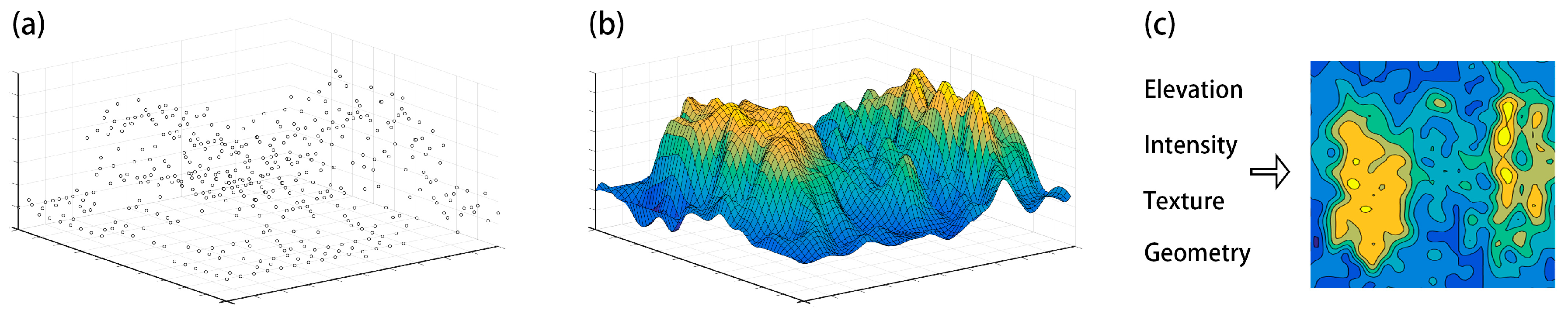
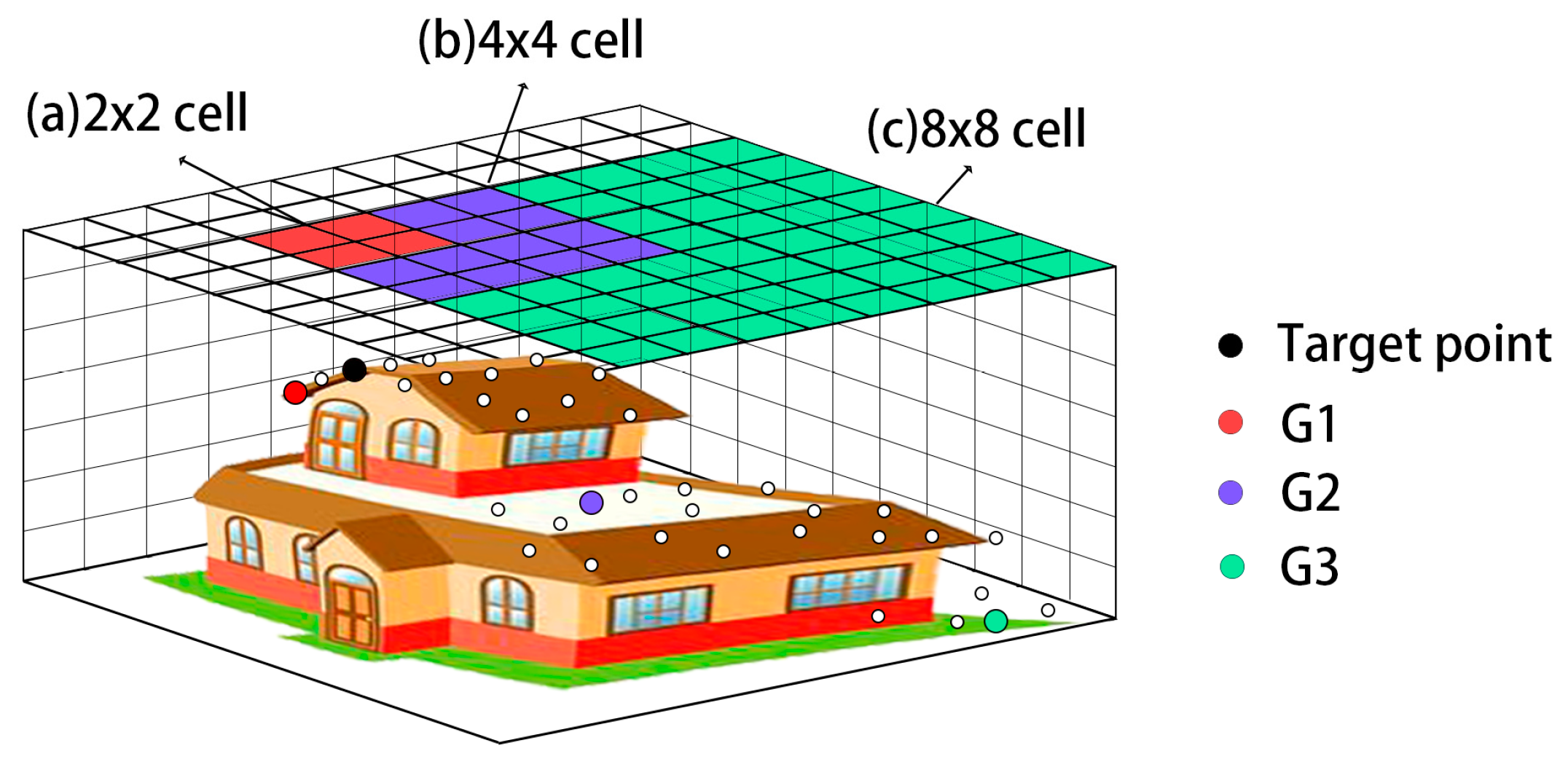
2.3. Interpolation
3. DTM Generation Methods for Different Categories
3.1. Surface-Based Adjustment
3.2. Morphology-Based Filtering
3.3. Triangulated Irregular Network (TIN)-Based Refinement
3.4. Segmentation and Classification
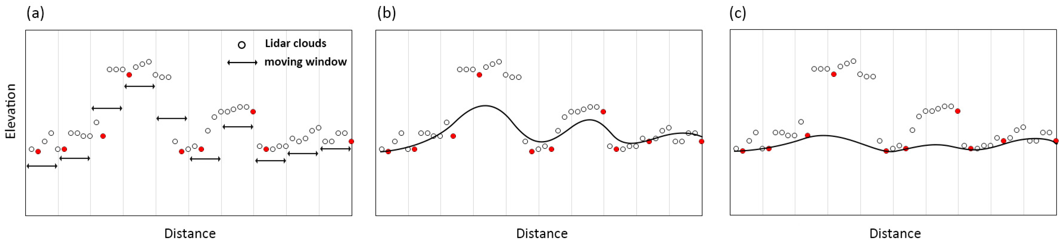
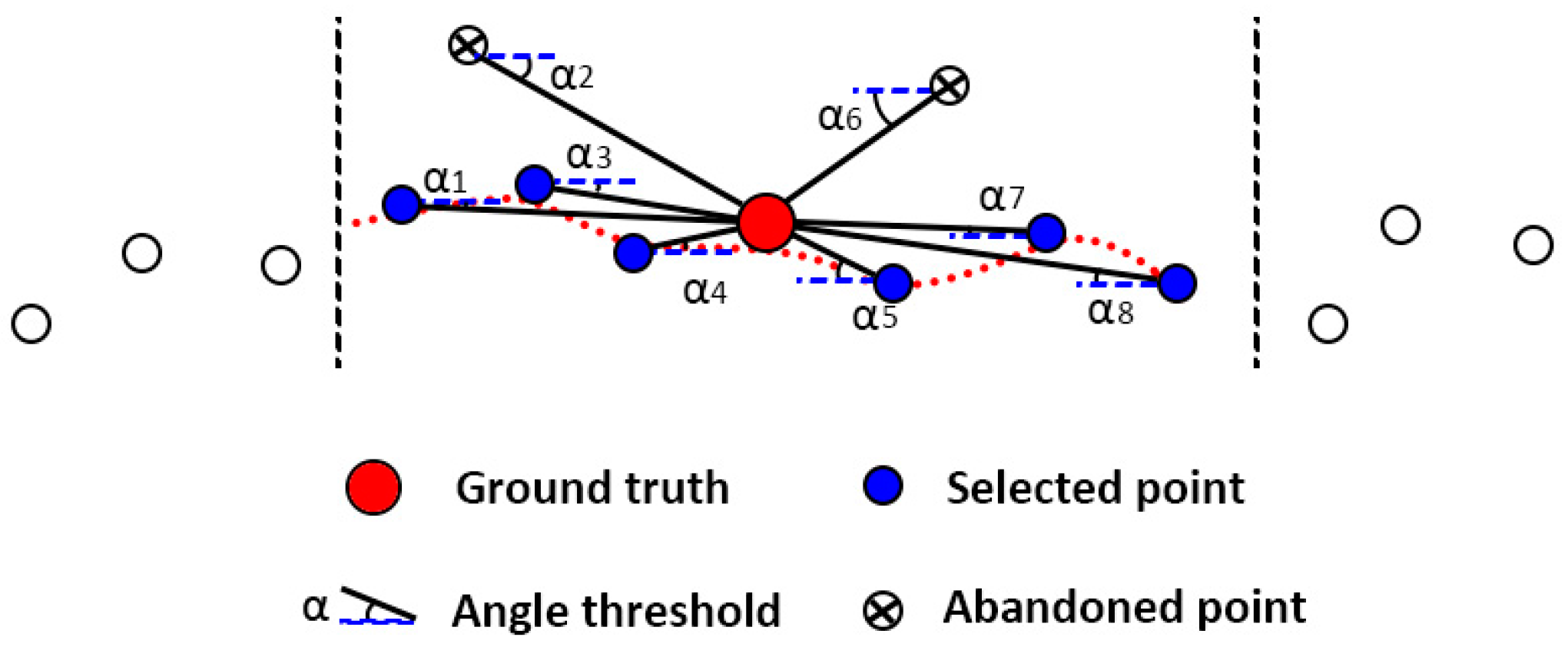
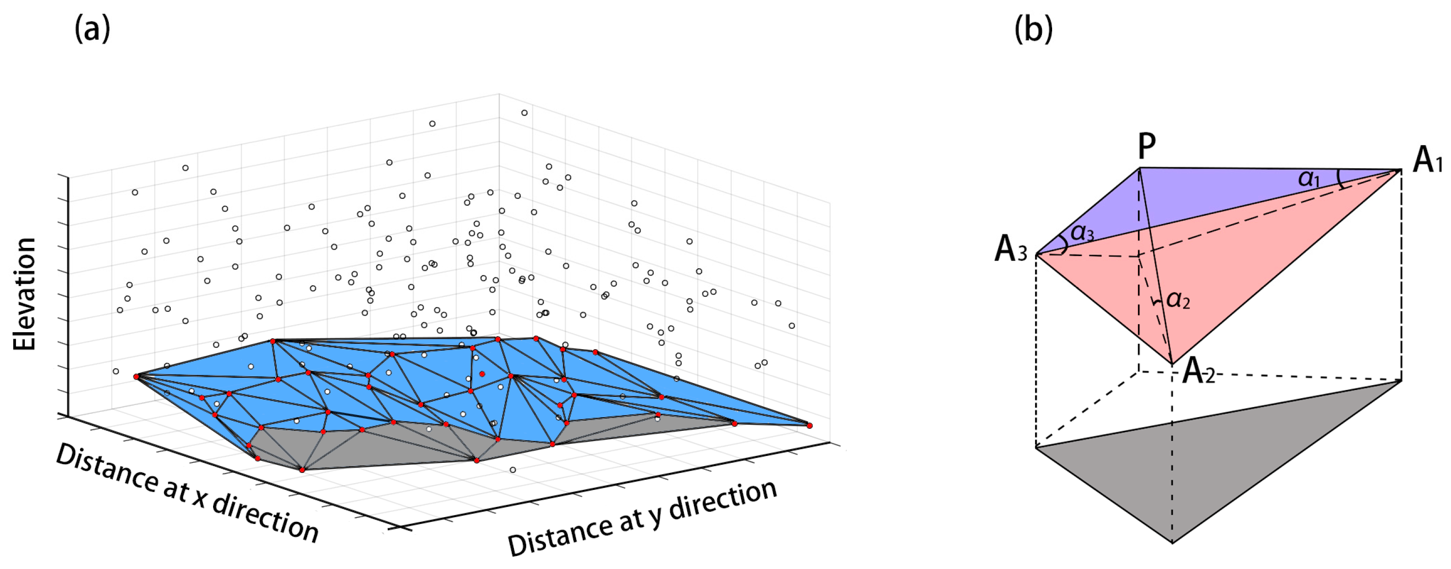
3.5. Statistical Analysis
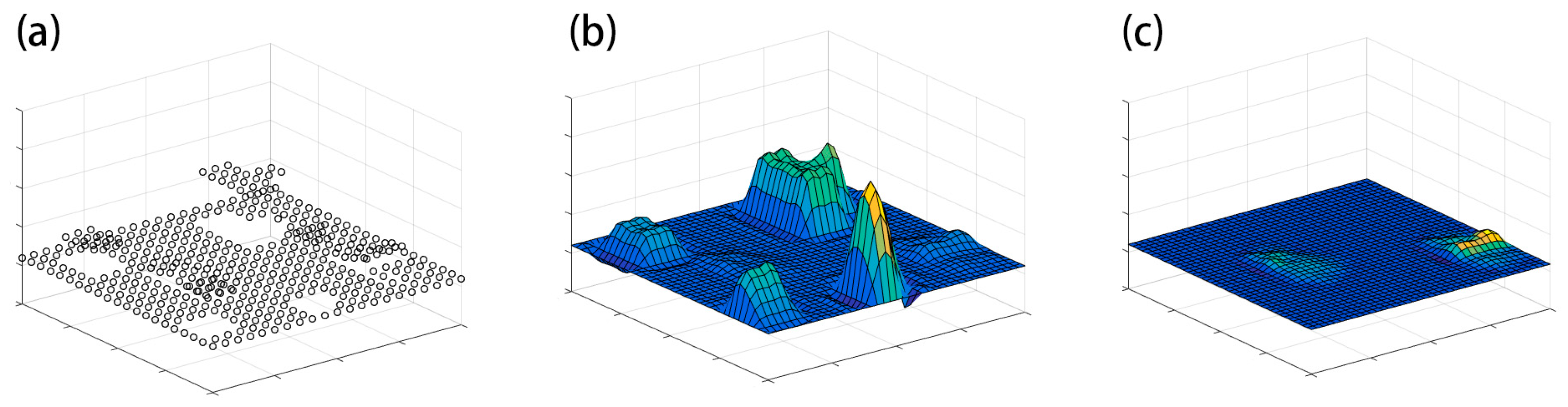
3.6. Multi-Scale Comparison
3.7. Overview of Different Ground Point Filters
4. Discussion
4.1. Recent Progress and Remaining Limitations in DTM Generation
4.1.1. DTM Generation with Improved Accuracy
4.1.2. DTM Generation and Presentation with Improved Computational Efficiency
4.1.3. Remaining Challenges for DTM Generation
4.2. Promising Directions
4.2.1. Advanced DTM Generation by Combining Different Methods
4.2.2. Advanced DTM Generation Using Multi-Sources
5. Summary
Acknowledgments
Author Contributions
Conflicts of Interest
References
- Sithole, G.; Vosselman, G. Comparison of filtering algorithms. Int. Arch. Photogramm. Remote Sens. Spat. Inf. Sci. 2003, 34, 71–78. [Google Scholar]
- Chen, Z.Y.; Devereux, B.; Gao, B.B.; Amable, G. Upward-fusion urban DTM generating method using airborne Lidar data. ISPRS J. Photogramm. Remote Sens. 2012, 72, 121–130. [Google Scholar] [CrossRef]
- Lu, W.; Murphy, K.P.; Little, J.J.; Sheffer, A.; Fu, H. A Hybrid Conditional Random Field for Estimating the Underlying Ground Surface from Airborne LiDAR Data. IEEE Trans. Geosci. Remote Sens. 2009, 47, 2913–2922. [Google Scholar]
- Vu, T.T.; Tokunaga, M.; Yamazaki, F. LiDAR signatures to update Japanese building inventory database. In Proceedings of the 25th Asian Confence on Remote Sensing, Chiang Mai, Thailand, 22–26 November 2004.
- Zhang, Y.; Men, L. Study of the airborne LIDAR data filtering methods. In Proceedings of the International Conference on Geoinformatics: Giscience in Change, Beijing, China, 18–20 June 2010.
- Liu, X.Y. Airborne LiDAR for DEM generation: Some critical issues. Prog. Phys. Geogr. 2008, 32, 31–49. [Google Scholar]
- Meng, X.; Currit, N.; Zhao, K. Ground Filtering Algorithms for Airborne LiDAR Data: A Review of Critical Issues. Remote Sens. 2010, 2, 833–860. [Google Scholar] [CrossRef]
- Jutzi, B.; Stilla, U. Waveform processing of laser pulses for reconstruction of surfaces in urban areas. In Proceedings of the Urban 2005, Tempe, AZ, USA, 14–16 March 2005.
- Mallet, C.; Bretar, F.; Soergel, U. Analysis of full-waveform Lidar data for classification of urban areas. Photogramm. Fernerkund. Geoinform. 2008, 5, 337–349. [Google Scholar]
- Mallet, C.; Bretar, F.; Roux, M.; Soergel, U.; Heipke, C. Relevance assessment of full-waveform lidar data for urban area classification. ISPRS J. Photogramm. Remote Sens. 2011, 66, S71–S84. [Google Scholar] [CrossRef]
- Doneus, M.; Briese, C. Full-waveform airborne laser scanning as a tool for archaeological reconnaissance. BAR Int. Ser. 2006, 1568, 99–106. [Google Scholar]
- Doneus, M.; Briese, C. Digital terrain modelling for archaeological interpretation within forested areas using fullwaveform laser scanning. In Proceedings of the 7th International Symposium on Virtual Reality, Archaeology and Cultural Heritage VAST, Nicosia, Cyprus, 30 October–4 November 2006.
- Meng, X.; Wang, L.; Silvan-Cardenas, J.L.; Currit, N. A multidirectional ground filtering algorithm for airborne Lidar. ISPRS J. Photogramm. Remote Sens. 2009, 64, 117–124. [Google Scholar] [CrossRef]
- Silvan-Cardenas, J.L.; Wang, L. A multi-resolution approach for filtering Lidar altimetry data. ISPRS J. Photogram. Remote Sens. 2006, 61, 11–22. [Google Scholar] [CrossRef]
- Meng, X.; Wang, L.; Currit, N. Morphology-based building detection from airborne LIDAR data. Photogramm. Eng. Remote Sens. 2009, 75, 437–442. [Google Scholar] [CrossRef]
- Chen, Q.; Gong, P.; Baldocchi, D.; Xie, G. Filtering airborne laser scanning data with morphological methods. Photogramm. Eng. Remote Sens. 2007, 73, 175–185. [Google Scholar] [CrossRef]
- Kobler, A.; Pfeifer, N.; Ogrinc, P.; Todorovski, L.; Ostir, K.; Dzeroski, S. Repetitive interpolation: A robust algorithm for DTM generation from aerial laser scanner data in forested terrain. Remote Sens. Environ. 2007, 108, 9–23. [Google Scholar] [CrossRef]
- Breunig, M.M.; Kriegel, H.P.; Ng, R.T.; Sander, J. LOF: Identifying density-based local outliers. In Proceedings of the ACM SIGMOD International Conference on Management of Data, Dallas, TX, USA, 15–18 May 2000; pp. 93–104.
- Sotoodeh, S. Hierarchical clustered outlier detection in laser scanner point clouds. Int. Arch. Photogramm. Remote Sens. 2007, 35, 383–388. [Google Scholar]
- Vain, A.; Kaasalainen, S. Correcting airborne laser scanning intensity data. In Laser Scanning, Theory and Applications; Wang, C.-C., Ed.; InTech: Rijeka, Croatia, 2011. [Google Scholar]
- Goovaerts, P. Geostatistics for Natural Resources Evaluation; Oxford University Press: New York, NY, USA, 1997; pp. 59–63. [Google Scholar]
- Isaaks, E.H.; Srivastava, R.M. An Introduction to Applied Geostatistics; Oxford University Press: New York, NY, USA, 1989. [Google Scholar]
- Fisher, P.F.; Tate, N.J. Causes and consequences of error in digital elevation models. Prog. Phys. Geogr. 2006, 30, 467–489. [Google Scholar] [CrossRef]
- Kraus, K.; Pfeifer, N. Determination of terrain models in wooded areas with airborne laser scanner data. ISPRS J. Photogramm. Remote Sens. 1998, 53, 193–203. [Google Scholar] [CrossRef]
- Kraus, K.; Pfeifer, N. Advanced DTM generation from LIDAR data. Int. Arch. Photogramm. Remote Sens. 2001, 34, 23–30. [Google Scholar]
- Elmqvist, M. Ground surface estimation from airborne laser scanner data using active shape models. Int. Arch. Photogramm. Remote Sens. Spat. Inf. Sci. 2002, 34, 114–118. [Google Scholar]
- Pfeifer, N.; Stadler, P.; Briese, C. Derivation of Digital Terrain Models in the SCOP ++ Environment. In Proceedings of the OEEPE Workshop on Airborne Laser Scanning and Interferometric SAR for Detailed Digital Elevation Models, Stockholm, Sweden, 1–3 March 2001.
- Wack, R.; Wimmer, A. Digital terrain models from airborne laser scanner data—A grid based approach. Int. Arch. Photogramm. Remote Sens. Spat. Inf. Sci. 2002, 34, 293–296. [Google Scholar]
- Chen, H.Y.; Cheng, M.S.; Li, J.; Liu, Y. An iterative terrain recovery approach to automated DTM. Int. Arch. Photogramm. Remote Sens. Spat. Inf. Sci. 2012, 39, 363–368. [Google Scholar] [CrossRef]
- Maguya, A.S.; Junttila, V.; Kauranne, T. Adaptive algorithm for large scale dtm interpolation from lidar data for forestry applications in steep forested terrain. ISPRS J. Photogramm. Remote Sens. 2013, 85, 74–83. [Google Scholar] [CrossRef]
- Zhang, W.M.; Qi, J.B.; Wan, P.; Wang, H.T.; Xie, D.H.; Wang, X.Y.; Yan, G.J. An Easy-to-Use Airborne LiDAR Data Filtering Method Based on Cloth Simulation. Remote Sens. 2016, 8, 501. [Google Scholar] [CrossRef]
- Mongus, D.; Zalik, B. Computationally Efficient Method for the Generation of a Digital Terrain Model from Airborne LiDAR Data Using Connected Operators. IEEE J. Sel. Top. Appl. Earth Obs. Remote Sens. 2014, 7, 340–351. [Google Scholar] [CrossRef]
- Vosselman, G. Slope based filtering of laser altimetry data. Int. Arch. Photogramm. Remote Sens. 2000, 3, 935–942. [Google Scholar]
- Sithole, G. Filtering of laser altimetry data using a slope adaptive filter. Int. Arch. Photogramm. Remote Sens. Spat. Inf. Sci. 2001, 34, 203–210. [Google Scholar]
- Roggero, M. Dense DTM from laser scanner data. In Proceedings of the OEPEE Workshop on Airborne Laser Scanning and Interferometric SAR, Stockholm, Sweden, 1–3 March 2001.
- Zakšek, K.; Pfeifer, N. An Improved Morphological Filter for Selecting Relief Points from a LIDAR Point Cloud in Steep Areas with Dense Vegetation; Technical Report; Institute of Anthropological and Spatial Studies: Ljubljana, Solvenia, 2006. [Google Scholar]
- Shao, Y.; Chen, L. Automated Searching of Ground Points from Airborne Lidar Data Using a Climbing and Sliding Method. Photogramm. Eng. Remote Sens. 2008, 74, 625–635. [Google Scholar] [CrossRef]
- Lohmann, P.; Koch, A.; Schaeffer, M. Approaches to the filtering of laser scanner data. Int. Arch. Photogramm. Remote Sens. 2000, 33, 540–547. [Google Scholar]
- Shan, J.; Sampath, A. Urban DEM Generation from Raw Lidar Data: A Labeling Algorithm and Its Performance. Photogramm. Eng. Remote Sens. 2005, 71, 217–226. [Google Scholar] [CrossRef]
- Wang, C.; Tseng, Y. Dual-directional profile filter for digital terrain model generation from airborne laser scanning data. J. Appl. Remote Sens. 2014, 8, 4480–4494. [Google Scholar] [CrossRef]
- Hu, X.; Ye, L.; Pang, S.; Shan, J. Semi-global filtering of airborne lidar data for fast extraction of digital terrain models. Remote Sens. 2015, 7, 10996–11015. [Google Scholar] [CrossRef]
- Li, Y.; Yong, B.; Wu, H.; An, R.; Xu, H. An improved top-hat filter with sloped brim for extracting ground points from airborne lidar point clouds. Remote Sens. 2014, 6, 12885–12908. [Google Scholar] [CrossRef]
- Susaki, J. Adaptive Slope Filtering of Airborne LiDAR Data in Urban Areas for Digital Terrain Model (DTM) Generation. Remote Sens. 2012, 4, 1804–1819. [Google Scholar] [CrossRef]
- Pingel, T.J.; Clarke, K.C.; McBride, W.A. An improved simple morphological filter for the terrain classification of airborne LIDAR data. ISPRS J. Photogramm. Remote Sens. 2013, 77, 21–30. [Google Scholar] [CrossRef]
- Axelsson, P. DEM generation form laser scanner data using adaptive TIN models. Int. Arch. Photogramm. Remote Sens. 2000, 4, 110–118. [Google Scholar]
- Sohn, G.; Dowman, I. Terrain surface reconstruction by the use of tetrahedron model with the mdl criterion. Int. Arch. Photogramm. Remote Sens. 2002, 34, 336–344. [Google Scholar]
- Guan, H.Y.; Li, J.; Yu, Y.T.; Zhong, L.; Ji, Z. DEM generation from lidar data in wooded mountain areas by cross-section-plane analysis. Int. J. Remote Sens. 2014, 35, 927–948. [Google Scholar] [CrossRef]
- Chen, Q.; Wang, H.; Zhang, H.; Sun, M.; Liu, X. A point cloud filtering approach to generating DTMs for steep mountainous areas and adjacent residential areas. Remote Sens. 2016, 8, 71. [Google Scholar] [CrossRef]
- Zhang, J.; Lin, X. Filtering airborne LiDAR data by embedding smoothness-constrained segmentation in progressive TIN densification. ISPRS J. Photogramm. Remote Sens. 2013, 81, 44–59. [Google Scholar] [CrossRef]
- Brovelli, M.A.; Cannata, M.; Longoni, U. Lidar data filtering and dtm interpolation within grass. Trans. GIS 2004, 8, 155–174. [Google Scholar] [CrossRef]
- Filin, S.; Pfeifer, N. Segmentation of Airborne Laser Scanning Data Using a Slope Adaptive Neighbourhood. ISPRS J. Photogramm. Remote Sens. 2006, 60, 71–80. [Google Scholar] [CrossRef]
- Lohmann, P. Segmentation and filtering of laser scanner digital surface models. Int. Arch. Photogramm. Remote Sens. Spat. Inf. Sci. 2002, 34, 311–316. [Google Scholar]
- Nardinocchi, C.; Forlani, G.; Zingaretti, P. Classification and filtering of laser data. In Proceedings of the ISPRS working group III/3 workshop 3-D Reconstruction from Airborne Laser Scanner and InSAR Data, Dresden, Germany, 8–10 October 2003.
- Niemeyer, J.; Rottensteiner, F.; Soergel, U. Contextual classification of lidar data and building object detection in urban areas. ISPRS J. Photogramm. Remote Sens. 2014, 87, 152–165. [Google Scholar] [CrossRef]
- Roggero, M. Airborne laser scanning: Clustering in raw data. Int. Arch. Photogramm. Remote Sens. Spat. Inf. Sci. 2001, 34, 227–232. [Google Scholar]
- Roggero, M. Object segmentation with region growing and principal component analysis. Int. Arch. Photogramm. Remote Sens. Spat. Inf. Sci. 2002, 34, 289–294. [Google Scholar]
- Sithole, G.; Vosselman, G. Filtering of airborne laser scanner data based on segmented point clouds. Workshop Laser Scanning 2005, 36, W19. [Google Scholar]
- Tovari, D.; Pfeifer, N. Segmentation based robust interpolation-a new approach to laser data filtering. Int. Arch. Photogramm. Remote Sens. Spat. Inf. Sci. 2005, 36, 79–84. [Google Scholar]
- Brennan, R.; Webster, T.L. Object-oriented land cover classification of lidar derived surfaces. Can. J. Remote Sens. 2006, 32, 162–172. [Google Scholar] [CrossRef]
- Buján, S.; González-Ferreiro, E.; Reyes-Bueno, F.; Barreiro-Fernández, L.; Crecente, R.; Miranda, D. Land use classification from LiDAR data and ortho-images in a rural area. Photogramm. Rec. 2012, 27, 401–422. [Google Scholar] [CrossRef]
- Chen, Z.Y.; Xu, B.; Gao, B.B. An Image-Segmentation-Based Urban DTM Generation Method Using Airborne Lidar Data. IEEE J. Sel. Top. Appl. Earth Obs. Remote Sens. 2016, 9, 496–506. [Google Scholar] [CrossRef]
- Kato, A.; Moskal, L.M.; Schiess, P.; Swanson, M.E.; Calhoun, D.; Stuetzle, W. Capturing tree crown formation through implicit surface reconstruction using airborne lidar data. Remote Sens. Environ. 2009, 113, 1148–1162. [Google Scholar] [CrossRef]
- Lee, A.C.; Lucas, R.M. A LiDAR-derived canopy density model for tree stem and crown mapping in Australian forests. Remote Sens. Environ. 2007, 111, 493–518. [Google Scholar] [CrossRef]
- Blaschke, T. Object based image analysis for remote sensing. ISPRS J. Photogramm. Remote Sens. 2010, 65, 2–16. [Google Scholar] [CrossRef]
- Blaschke, T.; Tomljenovic, I. LIDARScapes and OBIA. In Proceedings of the ASPRS Annual Conference, Sacramento, CA, USA, 19–23 March 2012.
- Antonarakis, A.S.; Richards, K.S.; Brasington, J. Object-based land cover classification using airborne LiDAR. Remote Sens. Environ. 2008, 112, 2988–2998. [Google Scholar] [CrossRef]
- Johansen, K.; Arroyo, L.A.; Armston, J.; Phinn, S.; Witte, C. Mapping riparian condition indicators in a sub-tropical savanna environment from discrete return lidar data using object-based image analysis. Ecol. Indic. 2010, 10, 796–807. [Google Scholar] [CrossRef]
- Im, J.; Jensen, J.R.; Hodgson, M.E. Object-based land cover classification using high-posting-density LiDAR data. GIScience Remote Sens. 2008, 45, 209–228. [Google Scholar] [CrossRef]
- Samadzadegan, F.; Bigdeli, B.; Ramzi, P. A multiple classifier system for classification of LiDAR remote sensing data using multi-class SVM. In Proceedings of the 9th International Conference on Multiple Classifier systems, Cairo, Egypt, 7–9 April 2010; pp. 254–263.
- Huang, X.; Zhang, L.; Gong, W. Information fusion of aerial images and LiDAR data in urban areas: Vector-stacking, re-classification and post-processing approaches. Int. J. Remote Sens. 2011, 32, 69–84. [Google Scholar] [CrossRef]
- Chen, Z.Y.; Gao, B.B. An Object-Based Method for Urban Land Cover Classification Using Airborne Lidar Data. IEEE J. Sel. Top. Appl. Earth Obs. Remote Sens. 2014, 10, 4243–4354. [Google Scholar] [CrossRef]
- Zhang, J.; Lin, X.; Ning, X. SVM-Based Classification of Segmented Airborne LiDAR Point Clouds in Urban Areas. Remote Sens. 2013, 5, 3749–3775. [Google Scholar] [CrossRef]
- Bartels, M.; Wei, H. Towards DTM generation from LIDAR data in hilly terrain using wavelets. In Proceedings of the 4th International Workshop on Pattern Recognition in Remote Sensing in Conjunction with ICPR 2006, Hong Kong, China, 20–24 August 2006; pp. 33–36.
- Bretar, F.; Chehata, N. Terrain Modeling from Lidar Range Data in Natural Landscapes: A Predictive and Bayesian Framework. IEEE Trans. Geosci. Remote Sens. 2010, 48, 1568–1578. [Google Scholar] [CrossRef]
- Bartels, M.; Wei, H. Threshold-free object and ground point separation in LIDAR data. Pattern Recognit. Lett. 2010, 31, 1089–1099. [Google Scholar] [CrossRef]
- Yao, W.; Hinz, S.; Stilla, U. Automatic vehicle extraction from airborne LiDAR data of urban areas using morphological reconstruction. In Proceedings of the 5th IAPRS Workshop on Pattern Recognition in Remote Sensing (PRRS 2008), Tampa, FL, USA, 7 December 2008; p. 4.
- Bao, Y.F.; Li, G.P.; Cao, C.X.; Li, X.W.; Zhang, H.; He, Q.S.; Bai, L.Y.; Chang, C.Y. Classification of LIDAR point cloud and generation of DTM from LIDAR height and intensity data in forested area. Int. Arch. Photogramm., Remote Sens. Spat. Inf. Sci. 2008, 37, 313–318. [Google Scholar]
- Mongus, D.; Zalik, B. Parameter-free ground filtering of LiDAR data for automatic DTM generation. ISPRS J. Photogramm. Remote Sens. 2012, 67, 1–12. [Google Scholar] [CrossRef]
- Zhang, K.Q.; Chen, S.C.; Whitman, D.; Shyu, M.L.; Yan, J.H.; Zhang, C.C. A progressive morphological filter for removing nonground measurements from airborne LIDAR data. IEEE Trans. Geosci. Remote Sens. 2003, 41, 872–882. [Google Scholar] [CrossRef]
- Li, S.W.; Sun, H.B.; Yan, L. A Filtering Method for Generating DTM based on Multi- scale Mathematic Morphology. In Proceedings of the 2011 IEEE. International Conference on Mechatronics and Automation, Beijing, China, 7–10 August 2011; pp. 693–697.
- Xiong, J.H.; Fang, Y.M.; Jin, B.X.; Zhao, Z.F. Automated DTM Generation in Urban Areas with Airborne LiDAR Data. In Proceedings of the 4th International Conference on Intelligent Human-Machine Systems and Cybernetics, Nanchang, China, 26–27 August 2012; pp. 181–184.
- Chen, C.F.; Li, Y.Y.; Li, W.; Dai, H.L. A multiresolution hierarchical classification algorithm for filtering airborne LiDAR data. ISPRS J. Photogramm. Remote Sens. 2013, 82, 1–9. [Google Scholar] [CrossRef]
- Mongus, D.; Lukač, N.; Žalik, B. Ground and building extraction from LiDAR data based on differential morphological profiles and locally fitted surfaces. ISPRS J. Photogramm. Remote Sens. 2014, 7, 145–156. [Google Scholar] [CrossRef]
- Maguya, A.S.; Junttila, V.; Kauranne, T. Algorithm for Extracting Digital Terrain Models under Forest Canopy from Airborne LiDAR Data. Remote Sens. 2014, 6, 6524–6548. [Google Scholar] [CrossRef]
- Su, W.; Sun, Z.; Zhong, R.; Huang, J.; Li, M.; Zhu, J.; Zhang, K.; Wu, H.; Zhu, D. A new hierarchical moving curve-fitting algorithm for filtering lidar data for automatic DTM generation. Int. J. Remote Sens. 2015, 36, 3616–3635. [Google Scholar] [CrossRef]
- Mandlburger, G.; Pfeifer, N.; Ressl, C.; Briese, C.; Roncat, A.; Lehner, H.; Mucke, W. Algorithms and Tools for Airborne LiDAR Data Processing from a Scientific Perspective; ELMF World Forum 2010: The Hague, The Netherlands, 2010. [Google Scholar]
- Forczmanski, P.; Maleika, W. Predicting the Number of DCT Coefficients in the Process of Seabed Data Compression. In Lecture Notes in Computer Science, Proceeding of the Computer Analysis of Images and Patterns, CAIP 2015, Ystad, Sweden, 2–4 September 2015; Springer International Publishing: Cham, Switzerland; Volume 9256, pp. 77–87.
- Forczmanski, P.; Maleika, W. Near-Lossless PCA-Based Compression of Seabed Surface with Prediction. In Lecture Notes in Computer Science, Proceeding of the Image Analysis and Recognition (ICIAR 2015), Niagara Falls, ON, Canada, 22–24 July 2015; Springer International Publishing: Cham, Switzerland; Volume 9164, pp. 119–128.
- Quintero, R.; Guzman, G.; Torres, M.; Menchaca-Mendez, R.; Moreno-Ibarra, M.; Mata, F. A Compression Algorithm for Managing Digital Elevation Models in Mobile Devices. J. Univers. Comput. Sci. 2014, 20, 1433–1442. [Google Scholar]
- Scarmana, G. Lossless data compression of grid-based digital elevation models: A PNG image format evaluation. In Proceedings of the ISPRS Technical Commission V Symposium, Close-Range Imaging, Ranging and Applications, Riva del Garda, Italy, 23–25 June 2014.
- Mohammadzadeh, A.; Valadan Zoej, M.J. A State of Art on Airborne Lidar Application in Hydrology and Oceanography: A Comprehensive Overview. Int. Arch. Photogramm. Remote Sens. Spat. Inf. Sci. 2008, 39, 315–320. [Google Scholar]
- Rottensteiner, F.; Trinder, J.; Clode, S.; Kubik, K. Using the Dempster–Shafer method for the fusion of LIDAR data and multi-spectral images for building detection. Inf. Fusion 2005, 6, 283–300. [Google Scholar] [CrossRef]
- Bork, E.; Su, J. Integrating LIDAR data and multispectral imagery for enhanced classification of rangeland vegetation: A meta analysis. Remote Sens. Environ. 2007, 111, 11–24. [Google Scholar] [CrossRef]
- Singh, K.; Vogler, J.B.; Shoemaker, D.A.; Meentemeyer, R.K. LiDAR-Landsat data fusion for large-area assessment of urban land cover: Balancing spatial resolution, data volume and mapping accuracy. ISPRS J. Photogramm. Remote Sens. 2012, 74, 110–121. [Google Scholar] [CrossRef]
- Chen, Y.H.; Su, W.; Li, J.; Sun, Z.P. Hierarchical object oriented classification using very high resolution imagery and LIDAR data over urban areas. Adv. Space Res. 2009, 43, 1101–1110. [Google Scholar] [CrossRef]
- Ke, Y.H.; Quackenbush, L.J.; Im, J. Synergistic use of QuickBird multispectral imagery and LIDAR data for object-based forest species classification. Remote Sens. Environ. 2010, 114, 1141–1154. [Google Scholar] [CrossRef]
- Syed, S.; Dare, P.; Jones, S. Automatic Classification of Land Cover Features with High Resolution Imagery and LIDAR Data: An Object-Oriented Approach. Available online: http://www.ecognition.com/sites/default/files/266_0185.pdf. 2005 (accessed on 1 September 2005).
- Teo, T.A.; Chen, L.C. Object-based building detection from LiDAR data and high resolution satellite imagery. In Proceedings of the Asian Conference on Remote Sensing, Ching-Mai, Thailand, 22–26 November 2004.
- Hill, R.A.; Thomson, A.G. Mapping woodland species composition and structure using airborne spectral and LiDAR data. Int. J. Remote Sens. 2005, 26, 3763–3779. [Google Scholar] [CrossRef]
- Dalponte, M.; Bruzzone, L.; Gianelle, D. Fusion of Hyperspectral and LIDAR Remote Sensing Data for Classification of Complex Forest Areas. IEEE Trans. Geosci. Remote Sens. 2008, 46, 416–1427. [Google Scholar] [CrossRef]
- Dalponte, M.; Bruzzone, L.; Gianelle, D. Tree species classification in the Southern Alps based on the fusion of very high geometrical resolution multispectral/hyperspectral images and LiDAR data. Remote Sens. Environ. 2012, 123, 258–270. [Google Scholar] [CrossRef]
- Luo, S.; Wang, C.; Xi, X.; Zeng, H.; Li, D.; Xia, S.; Wang, P. Fusion of Airborne Discrete-Return LiDAR and Hyperspectral Data for Land Cover Classification. Remote Sens. 2016, 8, 3. [Google Scholar] [CrossRef]
- Kim, Y.M.; Eo, Y.D.; Chang, A.J.; Kim, Y.I. Generation of a DTM and building detection based on an MPF through integrating airborne lidar data and aerial images. Int. J. Remote Sens. 2013, 34, 2947–2968. [Google Scholar] [CrossRef]
- Kim, Y.M.; Kim, Y. Improved Classification Accuracy Based on the Output-Level Fusion of High-Resolution Satellite Images and Airborne LiDAR Data in Urban Area. IEEE Geosci. Remote Sens. Lett. 2014, 11, 636–640. [Google Scholar]
- Nordbo, A.; Karsisto, P.; Matikainen, L.; Wood, C.R.; Järvi, L. Urban surface cover determined with airborne lidar at 2 m resolution—Implications for surface energy balance modelling. Urban Clim. 2015, 13, 52–72. [Google Scholar] [CrossRef]
- Debella-Gilo, M. Bare-earth extraction and DTM generation from photogrammetric point clouds including the use of an existing lower-resolution DTM. Int. J. Remote Sens. 2016, 37, 3104–3124. [Google Scholar] [CrossRef]
- Saeidi, V.; Pradhan, B.; Idrees, M.O.; Abd Latif, Z. Fusion of airborne lidar with multispectral spot 5 image for enhancement of feature extraction using dempster–shafer theory. IEEE Trans. Geosci. Remote Sens. 2014, 52, 6017–6025. [Google Scholar] [CrossRef]
- Toth, C.K. The State-of-the-Art in Airborne Data Collection Systems—Focused on LiDAR and Optical Imager. In Proceedings of the 100th Anniversary Photogrammetric Week (PhoWo 09), Stuttgart, Germany, 7–11 September 2009.
- Moretto, J.; Rigon, E.; Mao, L.; Delai, F.; Picco, L.; Lenzi, M.A. Short-term geomorphic analysis in a disturbed fluvial environment by fusion of lidar, colour bathymetry and dgps surveys. Catena 2014, 122, 180–195. [Google Scholar] [CrossRef]


| Filtering Methods | Suitable for | Not Suitable for | Memory Storage Demands | Computational Efficiency 2 |
|---|---|---|---|---|
| Surface-based | Forested areas | Rough and steep terrains | High | Middle |
| Morphology-based | Steepterrains 1, Terrains with small objects | Terrains with various objects | Low | High |
| TIN-based | Steep terrains | Urban areas, Discontinuous terrains | Middle | Middle |
| Segmentation-based | Urban areas, Terrains with various objects | Rough and steep terrains, Dense forests | NA 3 | NA 4 |
| Statistical analysis | Generally flat terrains | Terrains with various objects | Low | Low |
| Multi-scale comparison | Urban areas | Rough and steep terrains | Middle | Low |
© 2017 by the authors; licensee MDPI, Basel, Switzerland. This article is an open access article distributed under the terms and conditions of the Creative Commons Attribution (CC-BY) license (http://creativecommons.org/licenses/by/4.0/).
Share and Cite
Chen, Z.; Gao, B.; Devereux, B. State-of-the-Art: DTM Generation Using Airborne LIDAR Data. Sensors 2017, 17, 150. https://doi.org/10.3390/s17010150
Chen Z, Gao B, Devereux B. State-of-the-Art: DTM Generation Using Airborne LIDAR Data. Sensors. 2017; 17(1):150. https://doi.org/10.3390/s17010150
Chicago/Turabian StyleChen, Ziyue, Bingbo Gao, and Bernard Devereux. 2017. "State-of-the-Art: DTM Generation Using Airborne LIDAR Data" Sensors 17, no. 1: 150. https://doi.org/10.3390/s17010150
APA StyleChen, Z., Gao, B., & Devereux, B. (2017). State-of-the-Art: DTM Generation Using Airborne LIDAR Data. Sensors, 17(1), 150. https://doi.org/10.3390/s17010150