
Determination of Optimum Viewing Angles for the Angular Normalization of Land Surface Temperature over Vegetated Surface

 ,
,
Abstract
:
1. Introduction
2. Modeling of Directional Thermal Radiation

| SAA | SZA | LAI | Tleaf | Tsun_soil | Tshd_soil | ε v | ε g |
|---|---|---|---|---|---|---|---|
| 120° | 30° | 0.5~5.0 with a step of 0.5 | 305 K | 320 K | 315 K | 0.985 | 0.95 |

3. Viewing Angle Specification for Angular Normalization of LST
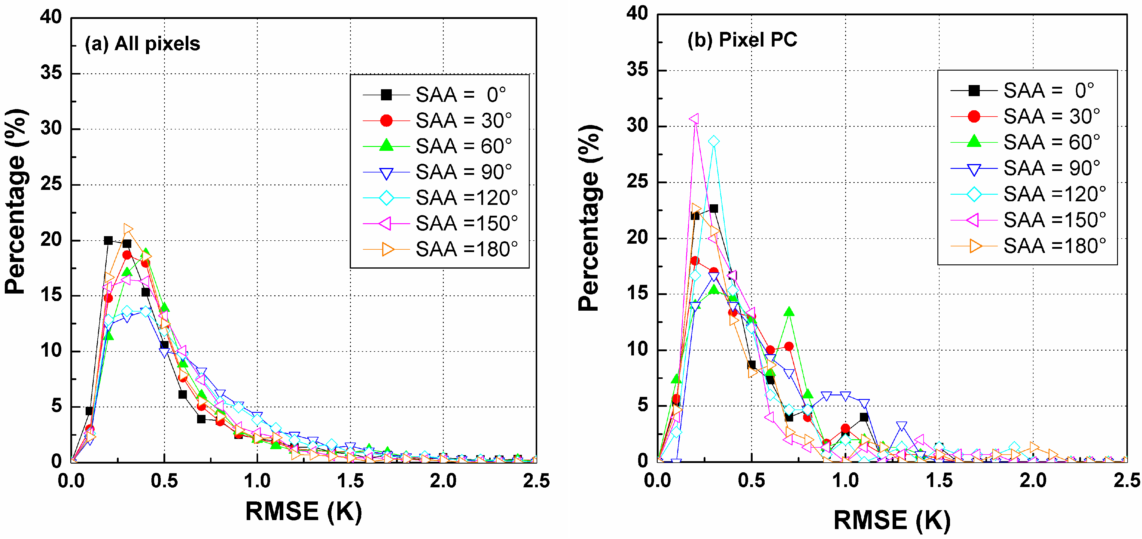
3.1. Single-Point Pattern Analysis for Multiple-Viewing Angle Specification
- (1)
- Most of the RMSEs in the TIR-BRDF model should fall in the range of 0.0~0.5 K.
- (2)
- The maximum difference should not or seldom occur for acceptable combinations of angles.
- (3)
- Most of the minimum differences can be obtained using the combinations.
- (4)
- Angle difference of the adjacent viewing angles should be large enough in order to cause large difference in the component fractions and then lead a large angular variation in the observed brightness temperature. But a very large VZA are not recommended in order to avoid large pixel size differences in the angle combination.
| 1st VAA | 1st VZA | 2nd VAA | 2nd VZA | 3rd VAA | 3rd VZA | RMSE [0.0~0.5] K | RMSE [0.5~1.0] K | Max * | Min # |
|---|---|---|---|---|---|---|---|---|---|
| 0 | 0 | 0 | 10 | 180 | 10 | 195 | 44 | 122 | 0 |
| 0 | 0 | 0 | 10 | 180 | 20 | 241 | 43 | 49 | 1 |
| 0 | 0 | 0 | 10 | 180 | 30 | 299 | 40 | 16 | 2 |
| 0 | 0 | 0 | 10 | 180 | 40 | 316 | 33 | 15 | 0 |
| 0 | 0 | 0 | 10 | 180 | 50 | 337 | 7 | 1 | 12 |
| 0 | 0 | 0 | 10 | 180 | 60 | 323 | 4 | 5 | 11 |
| 0 | 0 | 0 | 20 | 180 | 10 | 243 | 42 | 45 | 1 |
| 0 | 0 | 0 | 20 | 180 | 20 | 295 | 18 | 11 | 0 |
| 0 | 0 | 0 | 20 | 180 | 30 | 315 | 34 | 14 | 4 |
| 0 | 0 | 0 | 20 | 180 | 40 | 337 | 20 | 2 | 3 |
| 0 | 0 | 0 | 20 | 180 | 50 | 359 | 3 | 1 | 15 |
| 0 | 0 | 0 | 20 | 180 | 60 | 354 | 7 | 19 | 11 |
| 0 | 0 | 0 | 30 | 180 | 10 | 299 | 39 | 17 | 2 |
| 0 | 0 | 0 | 40 | 180 | 10 | 316 | 35 | 16 | 0 |
| 0 | 0 | 0 | 40 | 180 | 20 | 337 | 20 | 2 | 3 |
| 0 | 0 | 0 | 40 | 180 | 30 | 361 | 2 | 0 | 6 |
| 0 | 0 | 0 | 40 | 180 | 40 | 364 | 1 | 0 | 3 |
| 0 | 0 | 0 | 40 | 180 | 50 | 373 | 0 | 0 | 26 |
| 0 | 0 | 0 | 40 | 180 | 60 | 373 | 0 | 1 | 47 |
| 0 | 0 | 0 | 50 | 180 | 10 | 336 | 8 | 1 | 14 |
| 0 | 0 | 0 | 50 | 180 | 20 | 359 | 4 | 1 | 16 |
| 0 | 0 | 0 | 50 | 180 | 30 | 360 | 0 | 0 | 14 |
| 0 | 0 | 0 | 50 | 180 | 40 | 373 | 0 | 0 | 26 |
| 0 | 0 | 0 | 50 | 180 | 50 | 353 | 2 | 2 | 14 |
| 0 | 0 | 0 | 50 | 180 | 60 | 365 | 8 | 5 | 69 |
| 0 | 0 | 0 | 60 | 180 | 10 | 322 | 5 | 4 | 10 |
| 0 | 0 | 0 | 60 | 180 | 20 | 354 | 8 | 22 | 12 |
| 0 | 0 | 0 | 60 | 180 | 30 | 373 | 0 | 1 | 10 |
| 0 | 0 | 0 | 60 | 180 | 40 | 373 | 0 | 1 | 47 |
| 0 | 0 | 0 | 60 | 180 | 50 | 365 | 8 | 3 | 69 |
| 0 | 0 | 0 | 60 | 180 | 60 | 349 | 0 | 21 | 0 |

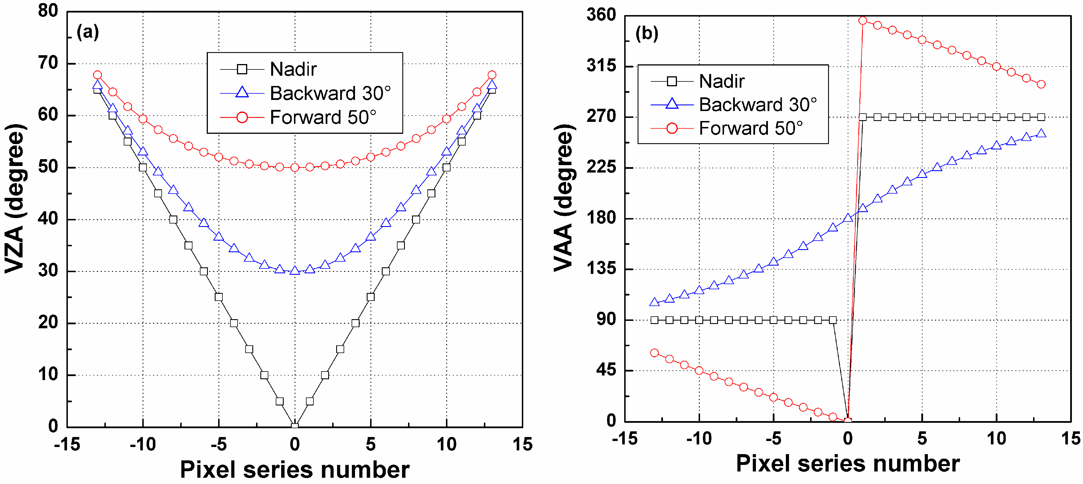
3.2. Linear-Array Pattern Analysis for Multiple-Viewing Angle Specification

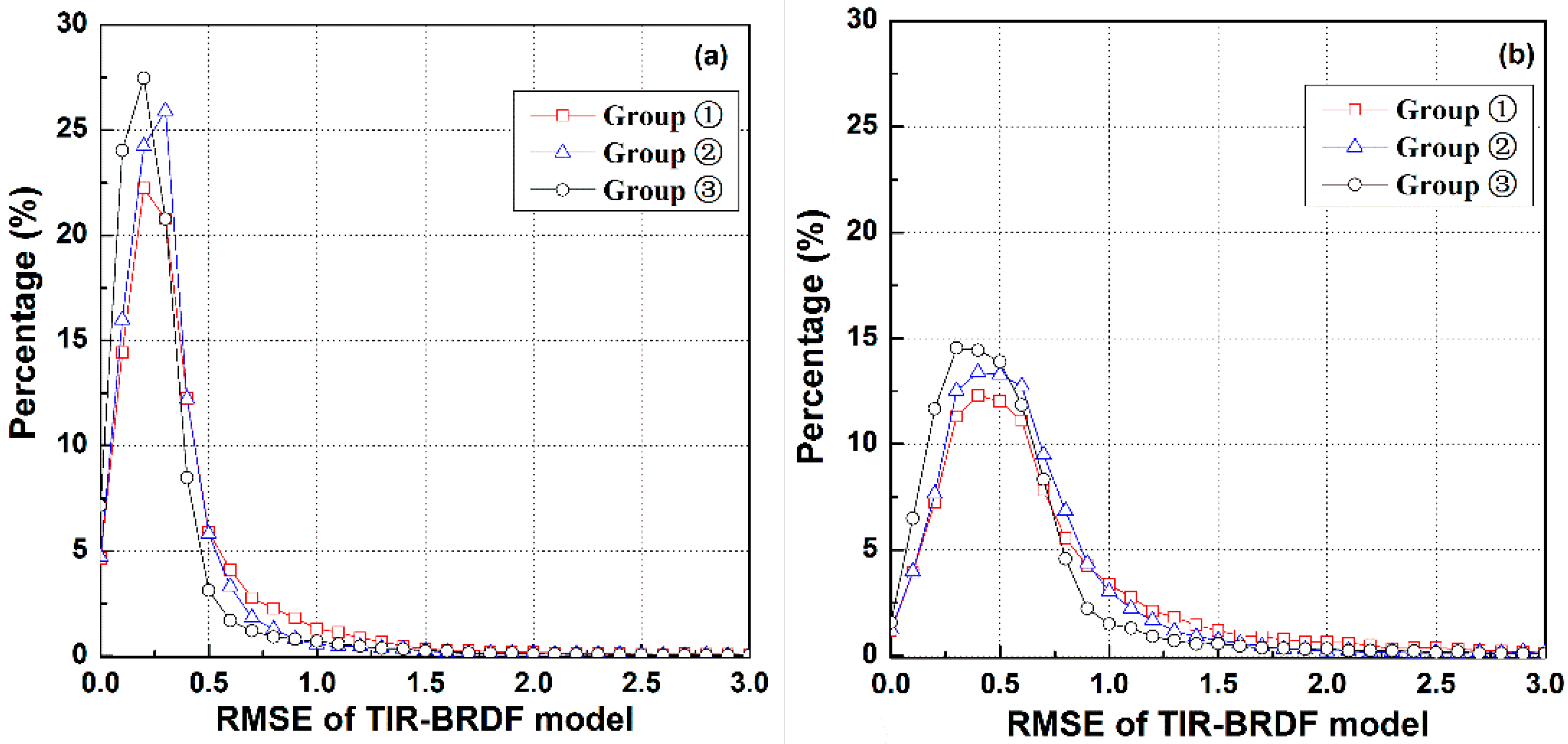
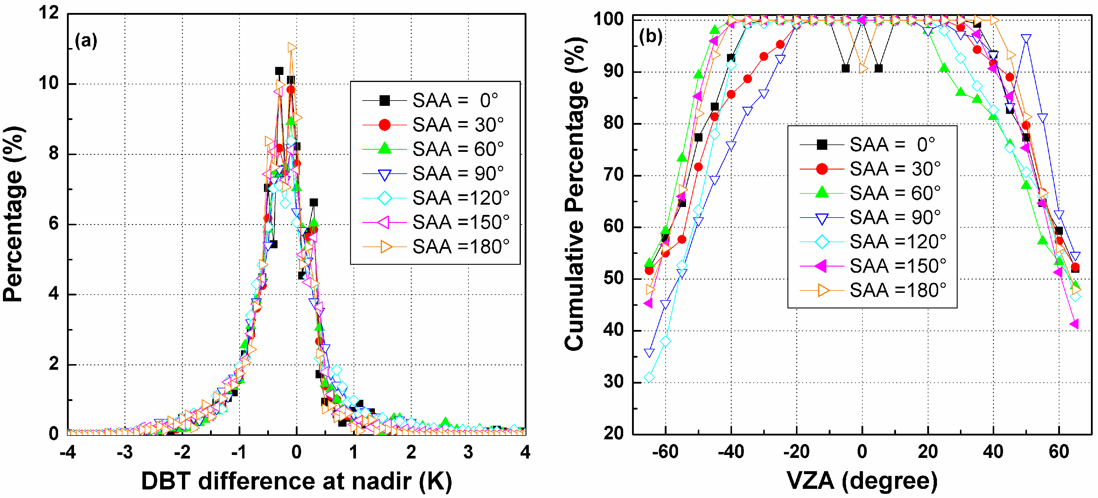
3.2.1. Influence of Solar Position
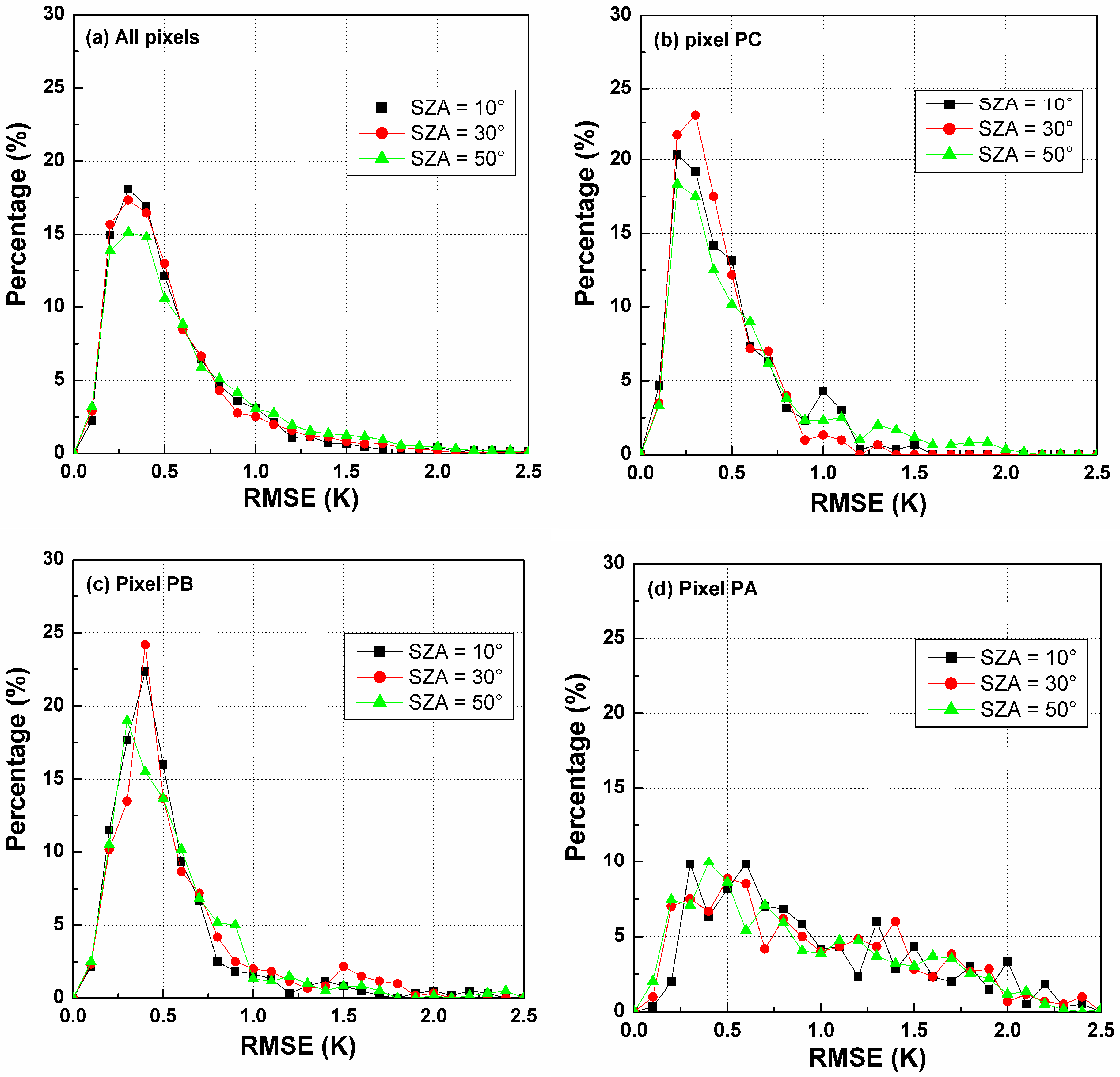
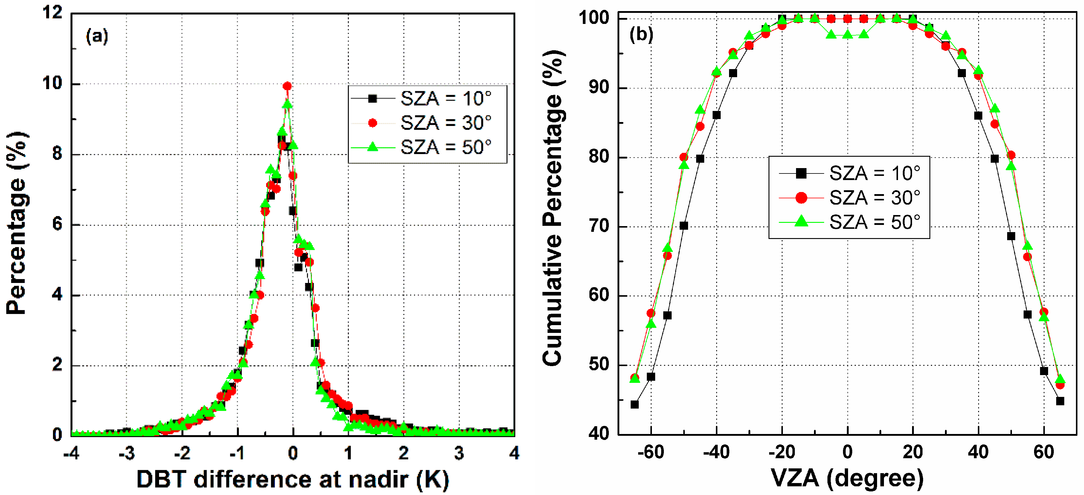
A. The Influence of SZA on the TIR-BRDF Model

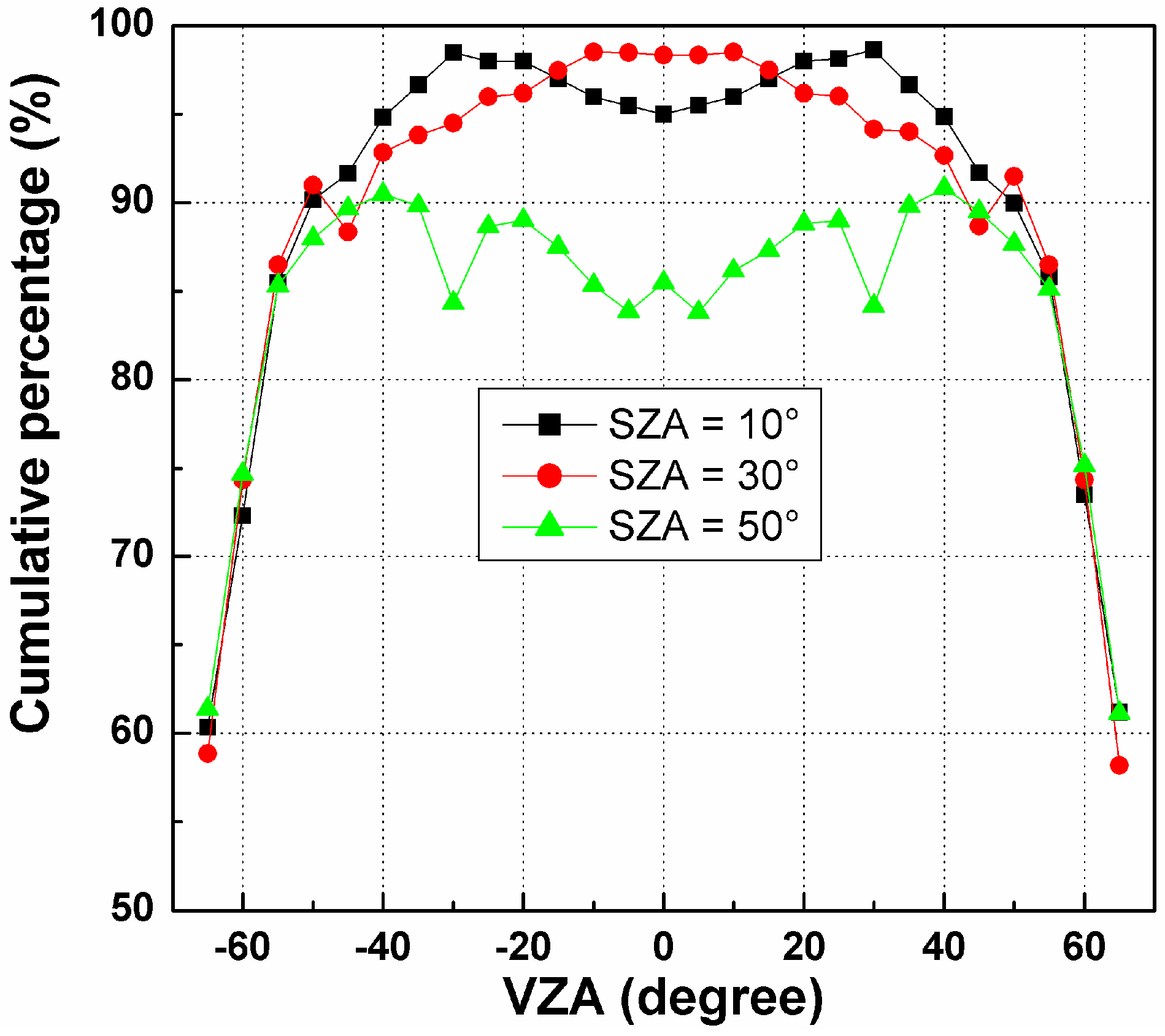
B. The Influence of SZA on Temperature Error in the Nadir Direction
C. The Influence of SAA on the TIR-BRDF Model
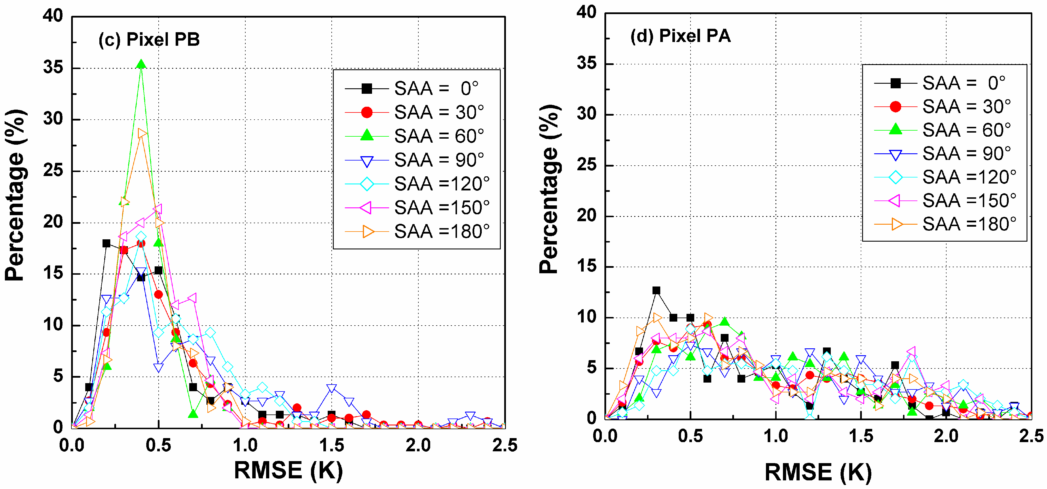
D. The Influence of SAA on Temperature Error at Nadir Observation
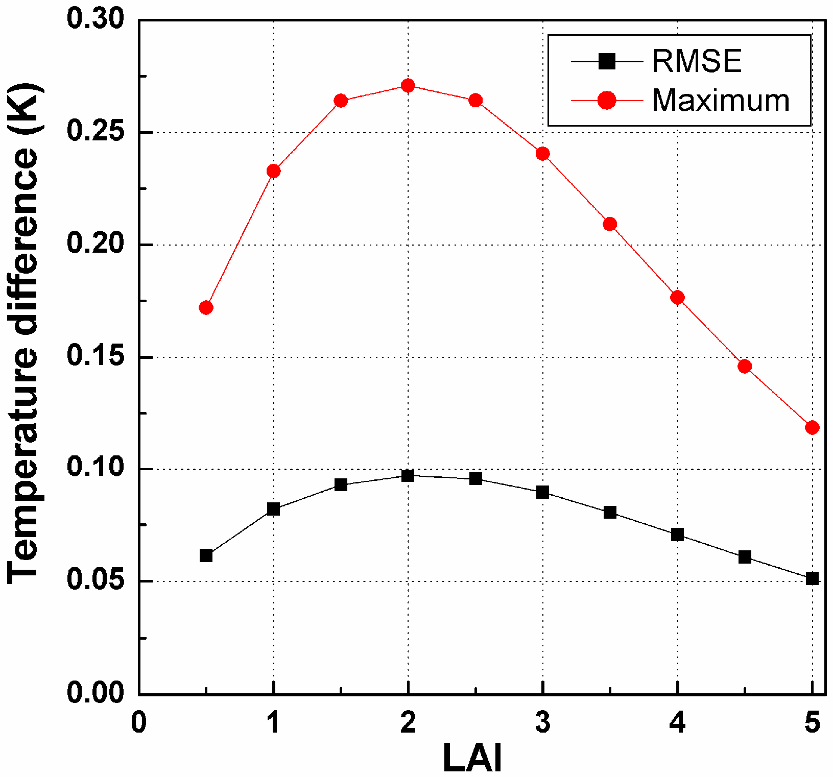
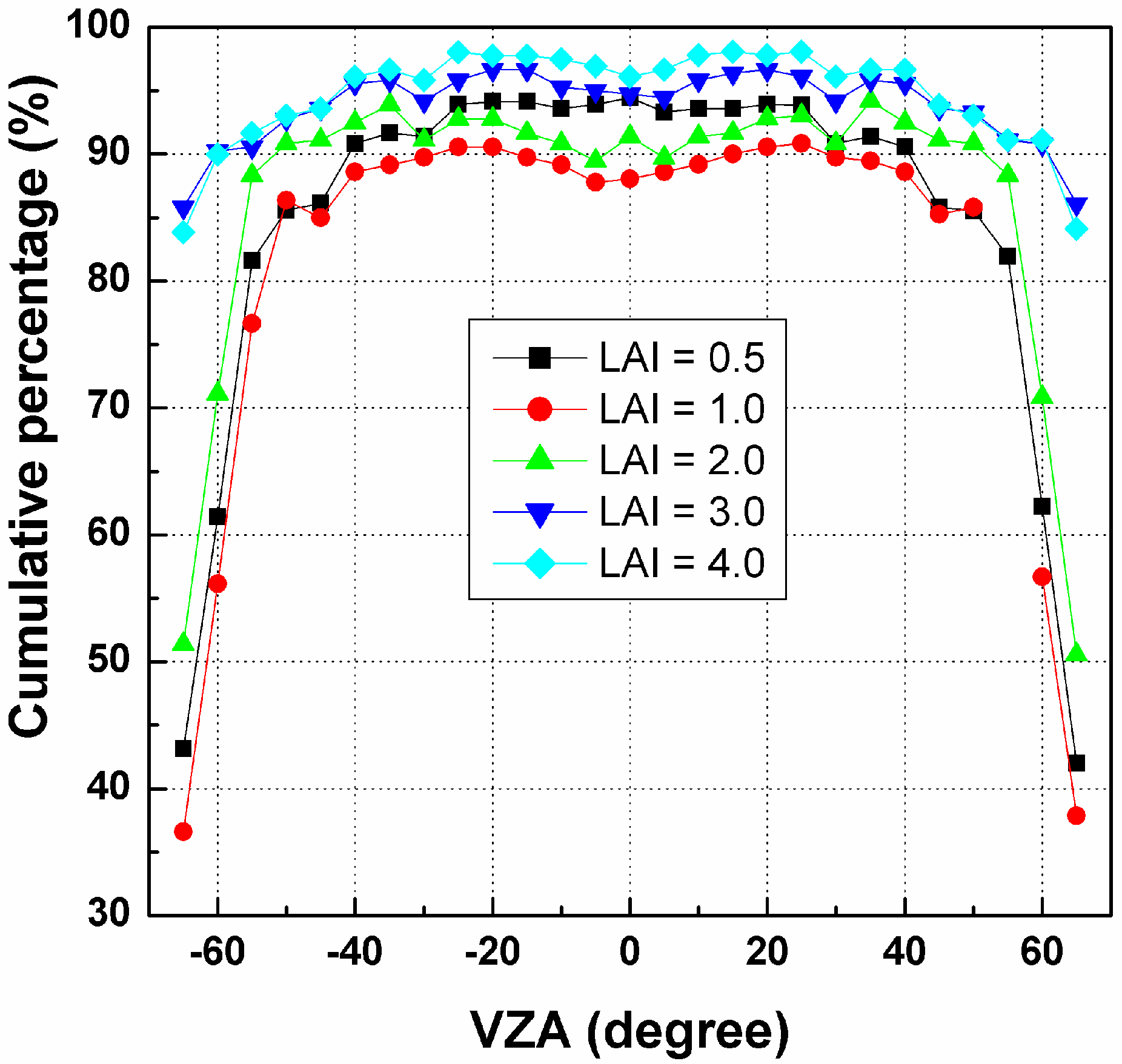
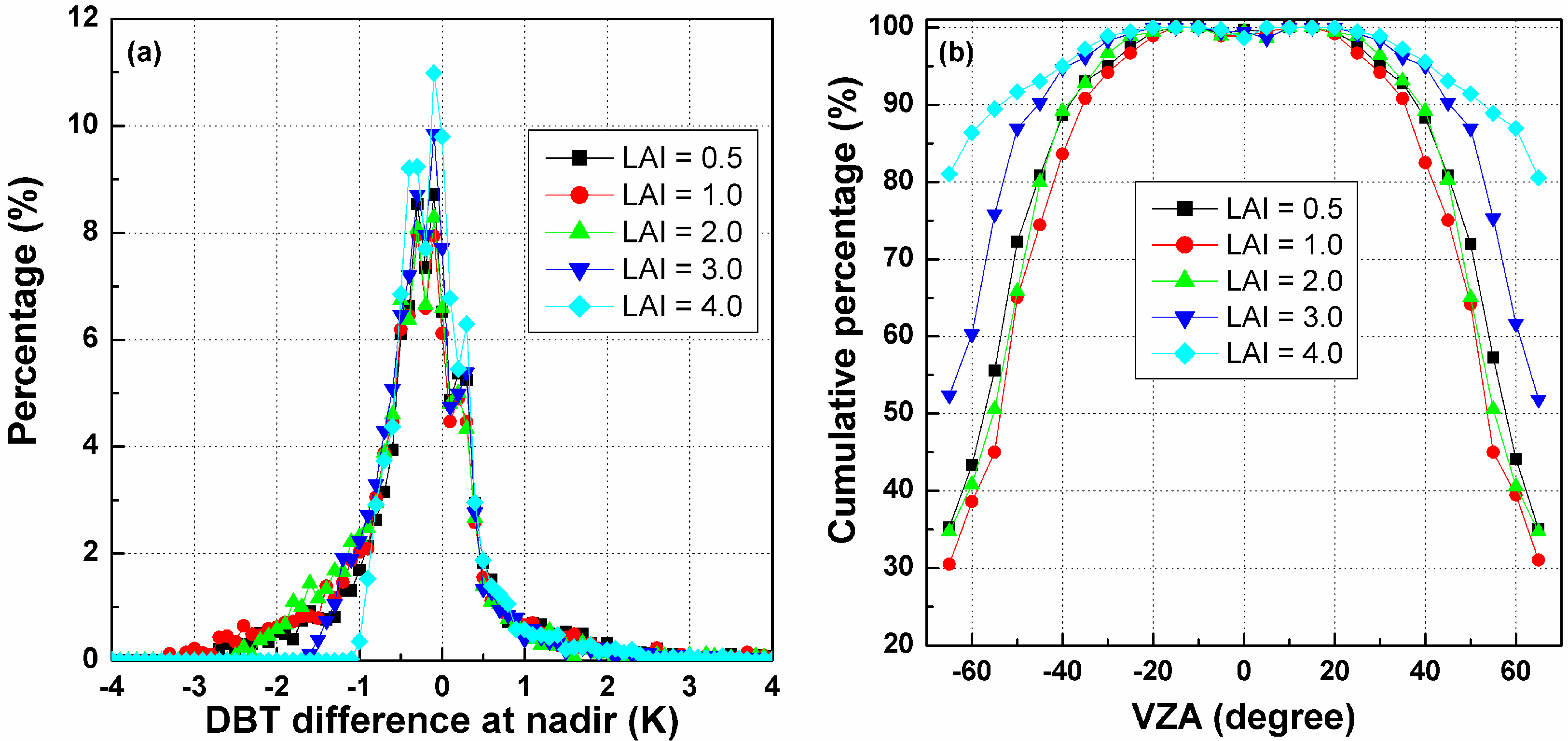
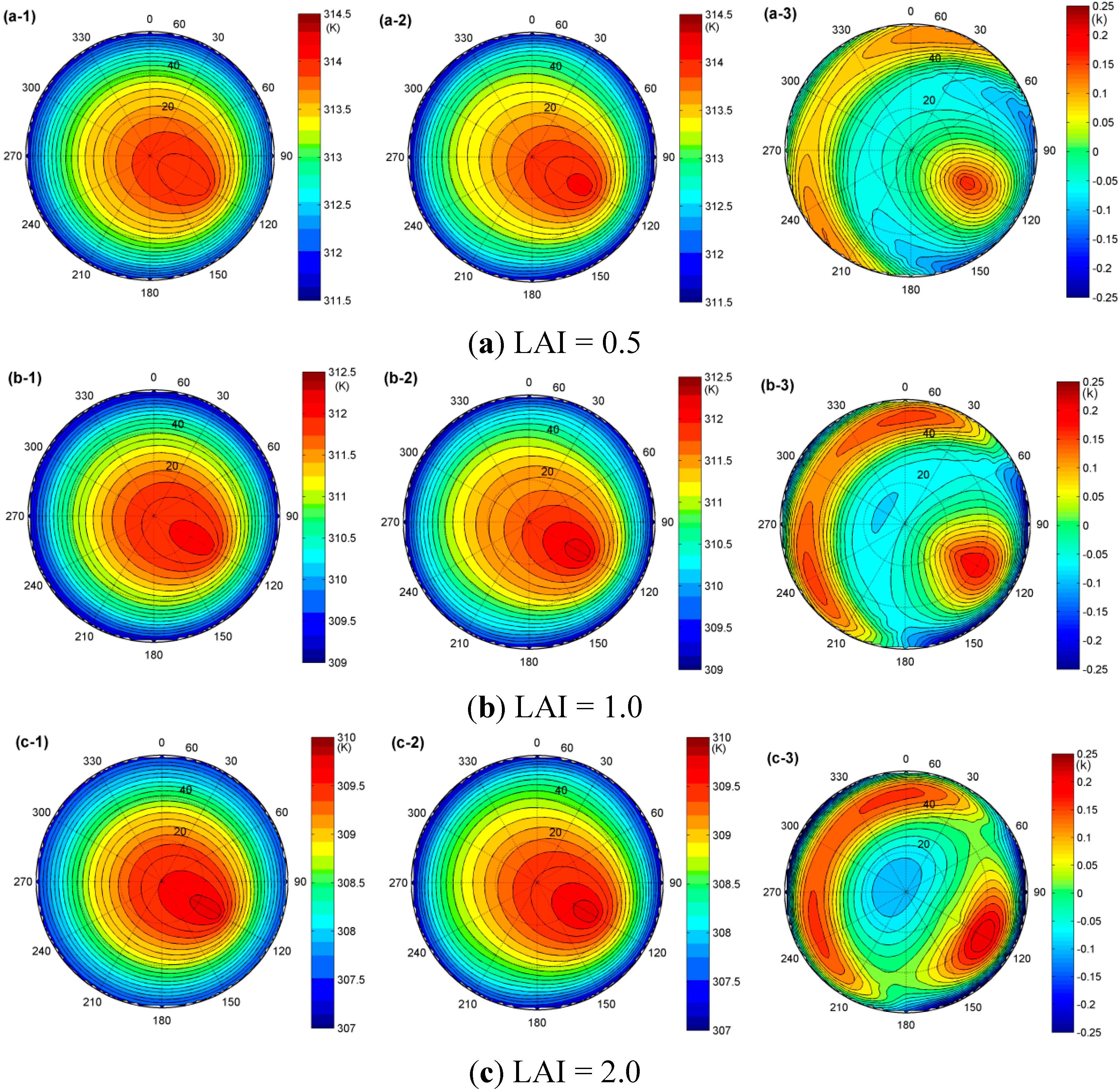
3.2.2. The Influence of LAI
A. The Influence of LAI on the TIR-BRDF Model
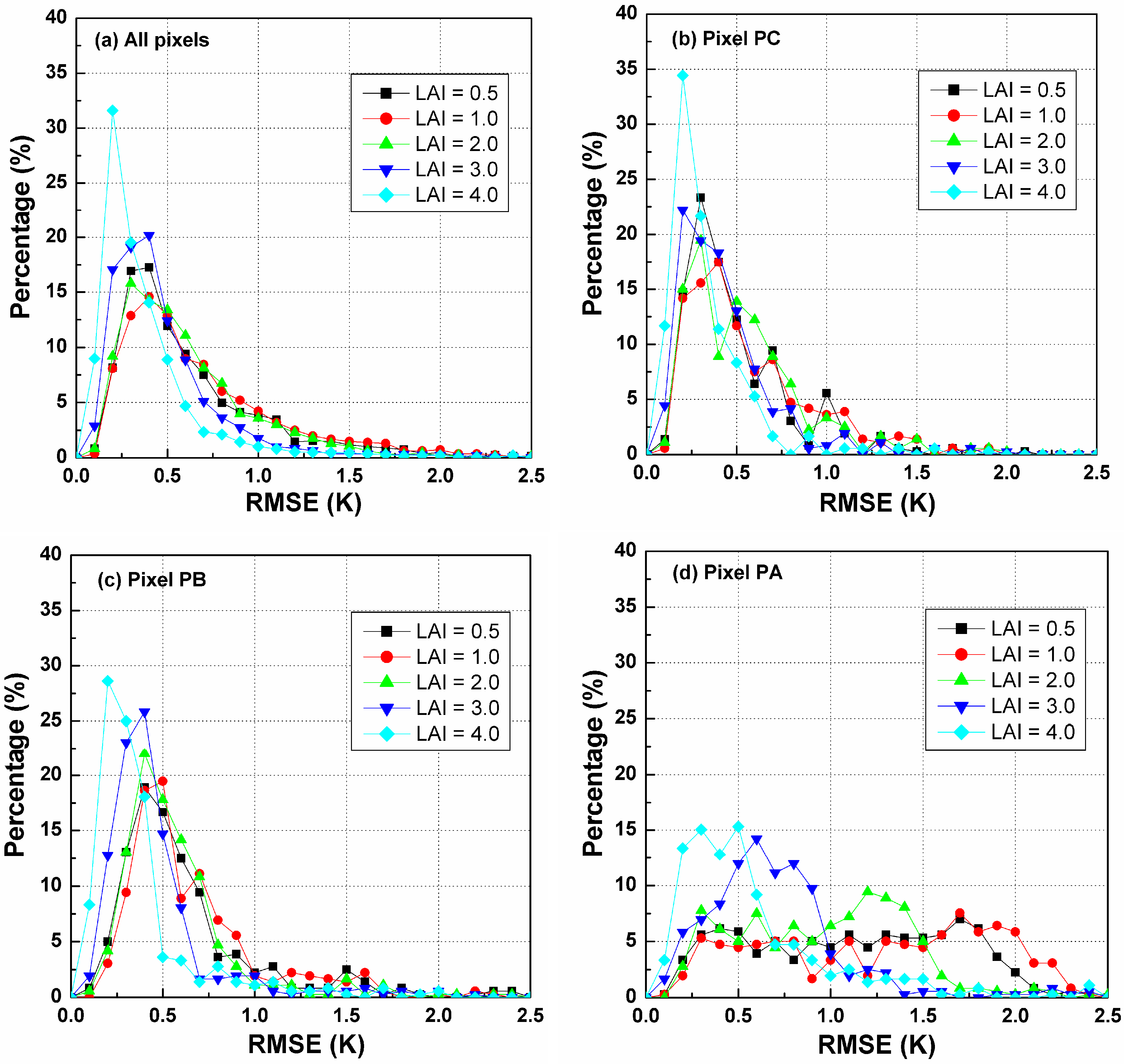

B. The Influence of LAI on Temperature Error at Nadir Observation

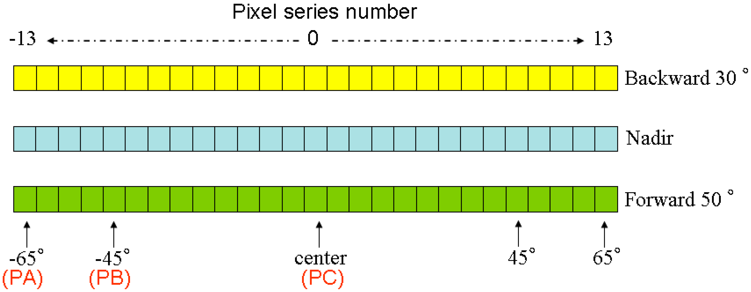
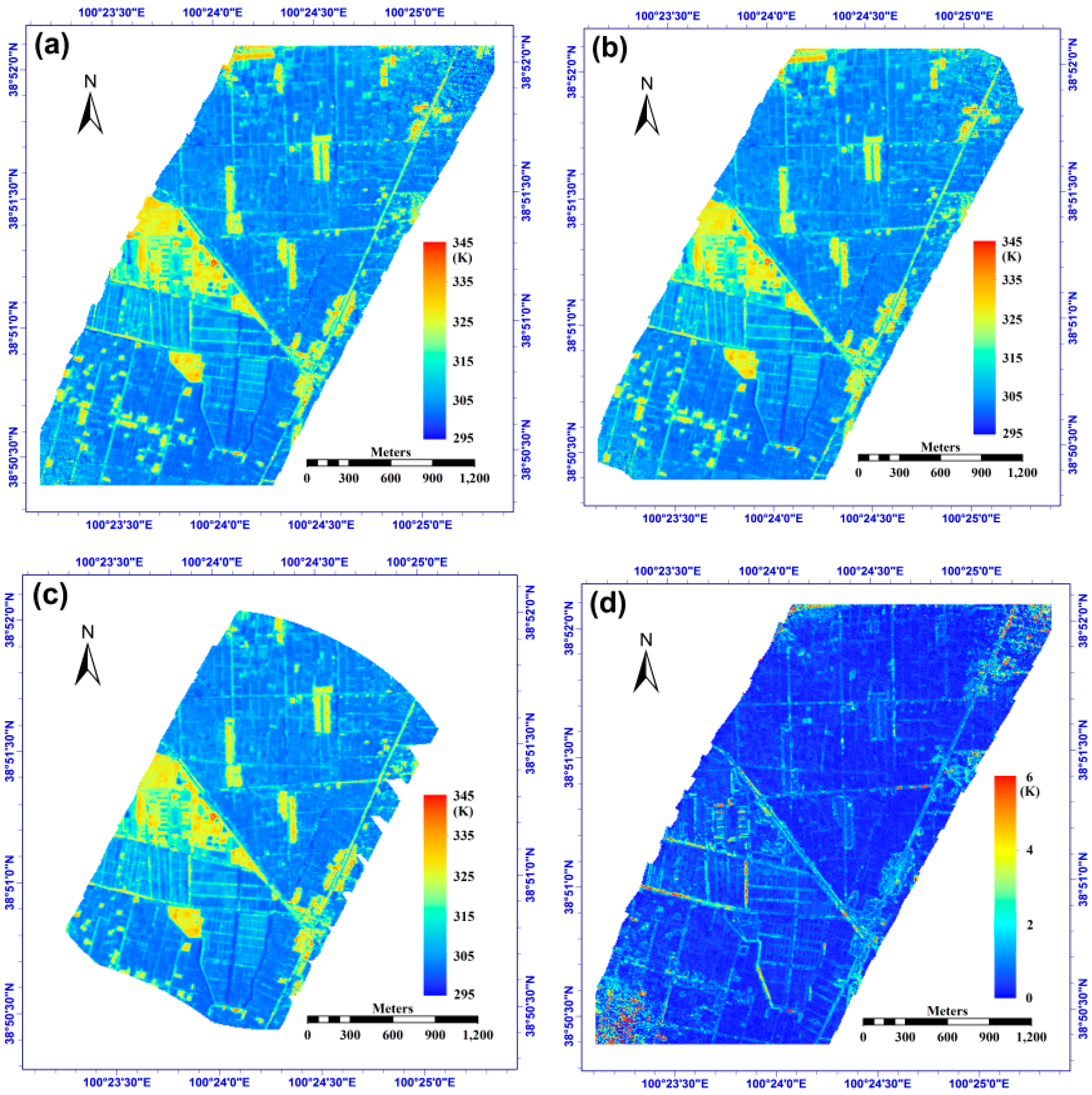
4. Application of TIR-BRDF Model to WiDAS Data
4.1. Airborne WiDAS System
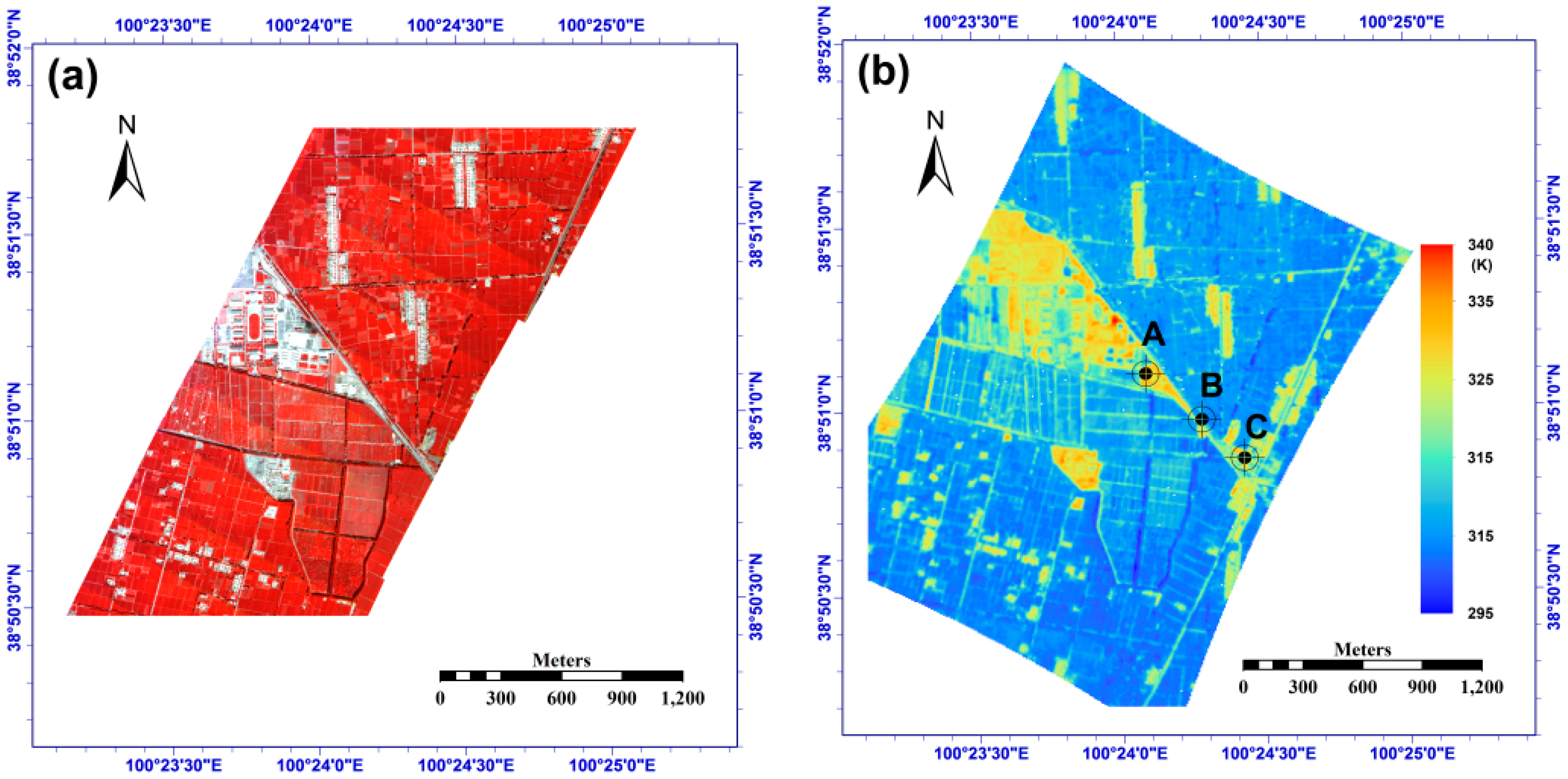
4.2. Study Area


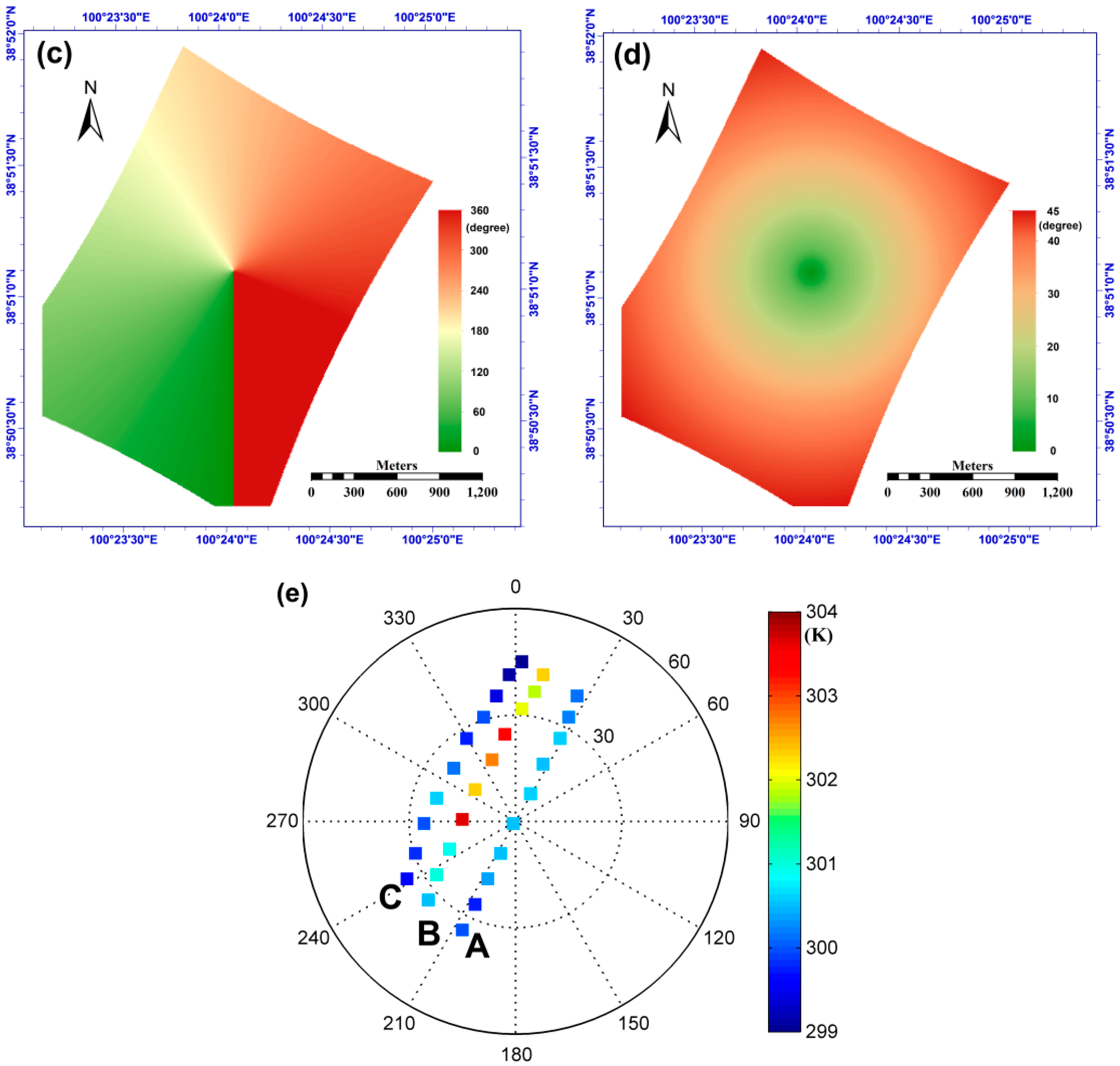
4.3. Angular Normalization of Temperature

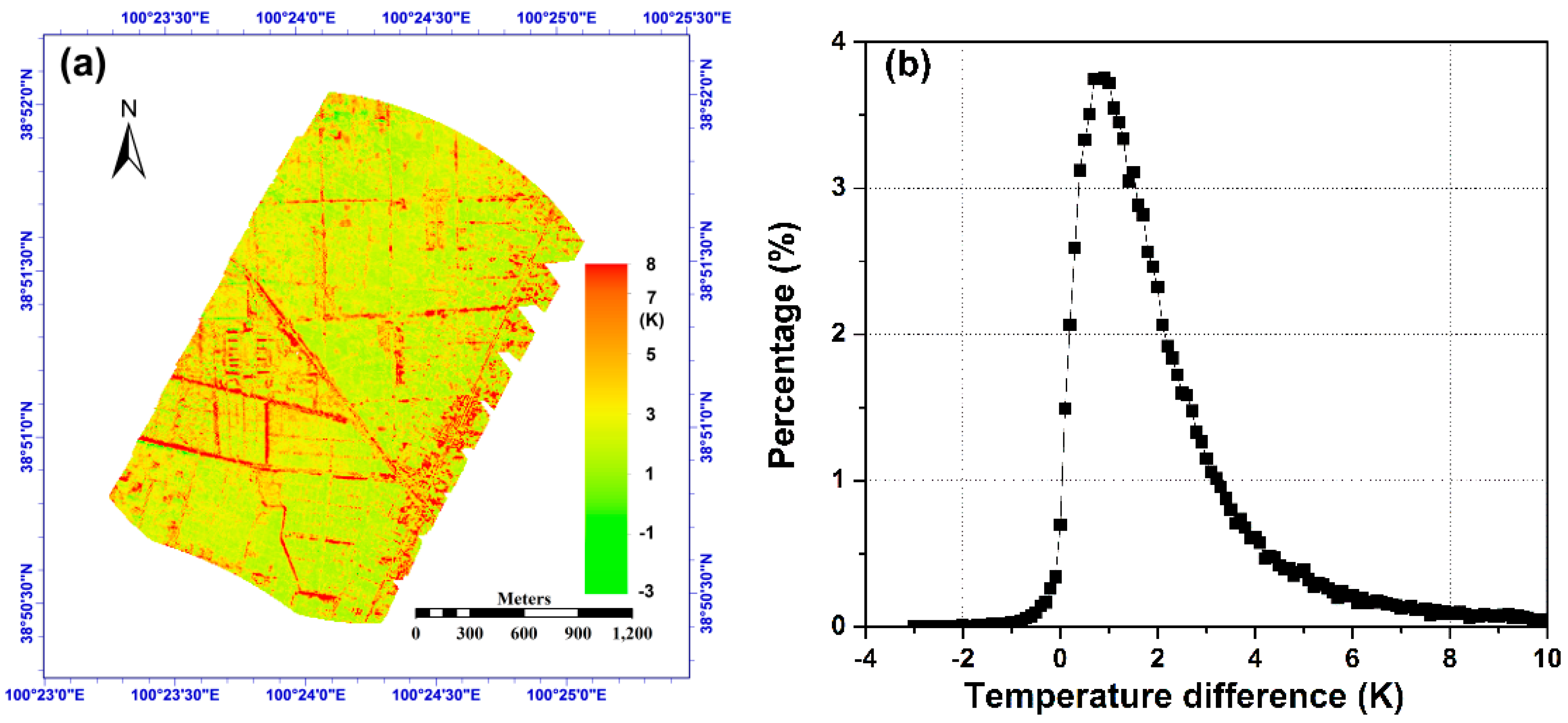
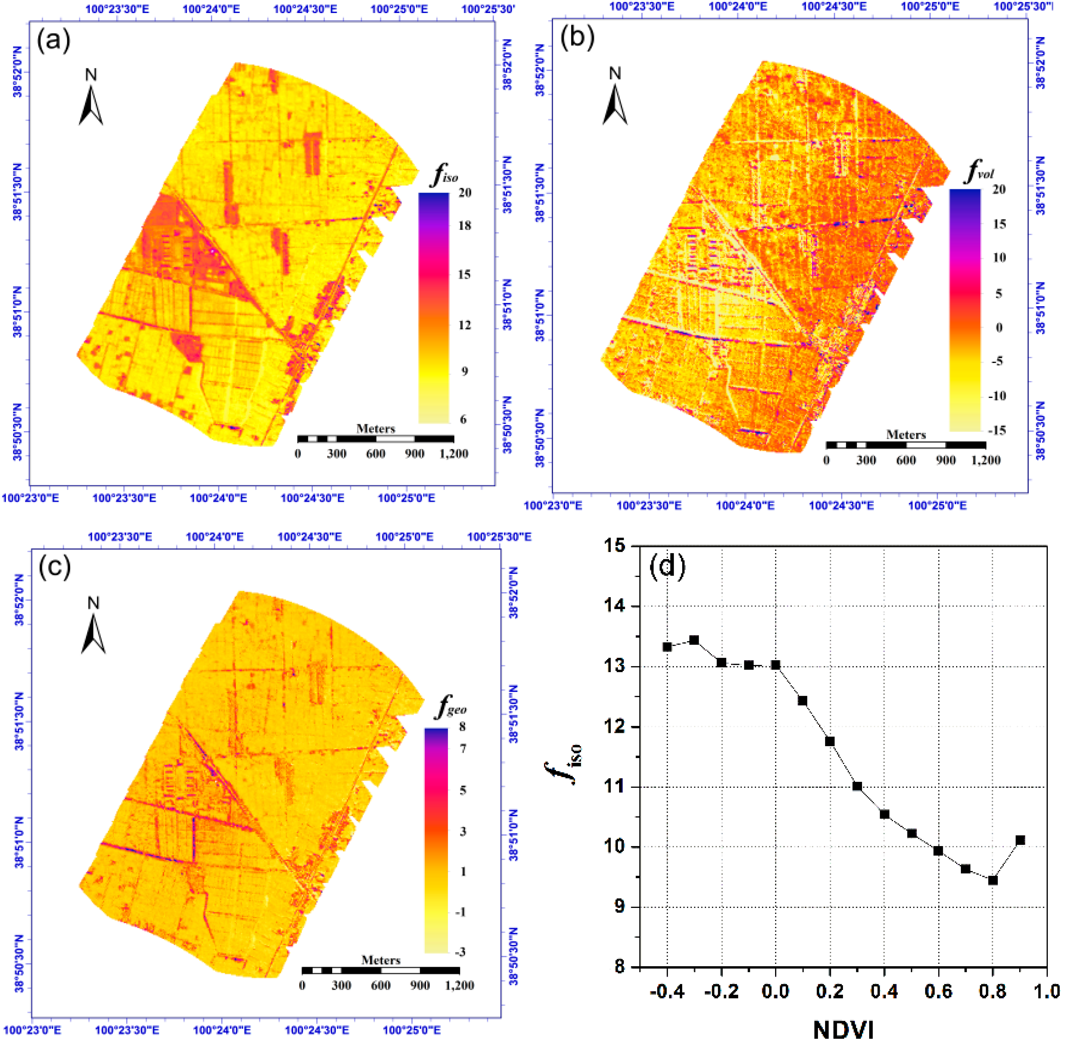
5. Discussions
6. Conclusions
Acknowledgments
Author Contributions
Conflicts of Interest
Appendix
| Abbreviation | Full Name | Abbreviation | Full Name |
|---|---|---|---|
| ATSR | Advanced Along Track Scanning Radiometer | RAA | Relative Azimuth Angle |
| AVHRR | Advanced Very High Resolution Radiometer | RMSE | Root-Mean-Square Error |
| BRDF | Bi-directional Reflectance Distribution Function | SAA | Solar Azimuth Angle |
| CCD | Charge Coupled Device | SAIL | Scattering by Arbitrarily Inclined Leaves |
| DBT | Directional Brightness Temperature | SEVIRI | Spinning Enhanced Visible and InfraRed Imager |
| DTR | Directional Thermal Radiance | SZA | Solar Zenith Angle |
| FIGOS | FIeld GOniometer System | Te-nadir | Nadir Effective Temperature |
| LAI | Leaf Area Index | TIR | Thermal Infrared |
| LST | Land Surface Temperature | TIR-BRDF | Thermal Infrared BRDF |
| MIR | Middle Infrared | TISI | Temperature-Independent Spectral Index |
| MAOS | portable Multi-Angle Observation System | VAA | Viewing Azimuth Angle |
| MODIS | Moderate Resolution Imaging Spectroradiometer | VZA | Viewing Zenith Angle |
| NDVI | Normalized Difference Vegetation Index | WATER | Watershed Allied Telemetry Experimental Research |
| PARABOLA | Rapid Acquisitions of Bi-directional Observations of Land and Atmosphere | WiDAS | Wide-angle infrared Dual-mode line/area Array Scanner |
References
- Hansen, J.; Ruedy, R.; Sato, M.; Lo, K. Global surface temperature change. Rev. Geophys. 2010, 48. [Google Scholar] [CrossRef]
- Weng, Q. Thermal infrared remote sensing for urban climate and environmental studies: Methods, applications, and trends. ISPRS J. Photogramm. 2009, 64, 335–344. [Google Scholar] [CrossRef]
- Li, Z.-L.; Tang, B.-H.; Wu, H.; Ren, H.; Yan, G.; Wan, Z.; Trigo, I.F.; Sobrino, J.A. Satellite-derived land surface temperature: Current status and perspectives. Remote Sens. Environ. 2013, 131, 14–37. [Google Scholar] [CrossRef]
- Li, Z.-L.; Wu, H.; Wang, N.; Qiu, S.; Sobrino, J.A.; Wan, Z.; Tang, B.-H.; Yan, G. Land surface emissivity retrieval from satellite data. Int. J. Remote Sens. 2013, 34, 3084–3127. [Google Scholar] [CrossRef]
- Sobrino, J.A.; Li, Z.-L.; Soria, G.; Jiménez, J.C. Land surface temperature and emissivity retrieval from remote sensing data. Recent Res. Develop. Geophys. 2002, 4, 21–44. [Google Scholar]
- Qin, Z.; Karnieli, A.; Berliner, P. A mono-window algorithm for retrieving land surface temperature from Landsat TM data and its application to the Israel-Egypt border region. Int. J. Remote Sens. 2001, 22, 3719–3746. [Google Scholar] [CrossRef]
- Jiménez-Muńoz, J.C.; Sobrino, J.A. A generalized single-channel method for retrieving land surface temperature from remote sensing data. J. Geophys. Res. 2003, 108. [Google Scholar] [CrossRef]
- Wan, Z.; Dozier, J. A generalized split-window algorithm for retrieving land-surface temperature from space. IEEE Trans. Geosci. Remote Sens. 1996, 34, 892–905. [Google Scholar] [CrossRef]
- Du, C.; Ren, H.; Qin, Q.; Meng, J.; Zhao, S. A practical split-window algorithm for estimating land surface temperature from Landsat 8 data. Remote Sens. 2015, 7, 647–665. [Google Scholar] [CrossRef]
- Gillespie, A.; Rokugawa, S.; Matsuuaga, T.; Cothern, J.S.; Hook, S.; Kahle, A.B. A temperature and emissivity separation algorithm for Advanced Spaceborne Thermal Emission and Reflection Radiometer (ASTER) images. IEEE Trans. Geosci. Remote Sens. 1998, 36, 1113–1126. [Google Scholar] [CrossRef]
- Hulley, G.C.; Hook, S.J. Generating consistent land surface temperature and emissivity products between ASTER and MODIS data for earth science research. IEEE Trans. Geosci. Remote Sens. 2011, 49, 1304–1315. [Google Scholar] [CrossRef]
- Becker, F.; Li, Z.-L. Temperature-independent spectral indices in thermal infrared bands. Remote Sens. Environ. 1990, 32, 17–33. [Google Scholar] [CrossRef]
- Jiang, G.-M.; Li, Z.-L.; Nerry, F. Land surface emissivity retrieval from combined mid-infrared and thermal infrared data of MSG-SEVIRI. Remote Sens. Environ. 2006, 105, 326–340. [Google Scholar] [CrossRef]
- Peres, L.F.; DaCamara, C.C. Land surface temperature and emissivity estimation based on the two-temperature method: sensitivity analysis using simulated MSG/SEVIRI data. Remote Sens. Environ. 2004, 91, 377–389. [Google Scholar] [CrossRef]
- Wan, Z.; Li, Z.-L. A physics-based algorithm for retrieving land-surface emissivity and temperature from EOS/MODIS data. IEEE Trans. Geosci. Remote Sens. 1997, 35, 980–996. [Google Scholar] [CrossRef]
- Chehbouni, A.; Nouvellon, Y.; Kerr, Y.H.; Moran, M.S.; Watts, C.; Prevot, L.; Goodrich, D.C.; Rambal, S. Directional effect on radiative surface temperature measurements over a semiarid grassland site. Remote Sens. Environ. 2001, 76, 360–372. [Google Scholar] [CrossRef]
- Coret, L.; Briottet, X.; Kerr, Y.H.; Chehbouni, A. Simulation study of view angle effects on thermal infrared measurements over heterogeneous surfaces. IEEE Trans. Geosci. Remote Sens. 2004, 42, 664–672. [Google Scholar] [CrossRef]
- Lagouarde, J.-P.; Moreaua, P.; Irvine, M.; Bonnefonda, J.-M.; Coll, C. Airborne experimental measurements of the angular variations in surface temperature over urban areas: Case study of Marseille (France). Remote Sens. Environ. 2004, 93, 443–462. [Google Scholar] [CrossRef]
- Minnis, P.; Khaiyer, M.M. Anisotropy of land surface skin temperature derived from satellite data. J. Appl. Meteorol. 2000, 39, 1117–1129. [Google Scholar] [CrossRef]
- Rasmussen, M.O.; Göttsche, F.-M.; Olesen, F.-S.; Sandholt, I. Directional effects on land surface temperature estimation from Meteosat Second Generation for savanna landscapes. IEEE Trans. Geosci. Remote Sens. 2011, 49, 4458–4468. [Google Scholar] [CrossRef]
- Ren, H.; Yan, G.; Chen, L.; Li, Z. Angular effect of MODIS emissivity products and its application to the split-window algorithm. ISPRS J. Photogramm. 2011, 66, 498–507. [Google Scholar] [CrossRef]
- Ren, H.; Liu, R.; Yan, G.; Mu, X.; Li, Z.-L.; Nerry, F.; Liu, Q. Angular normalization of land surface temperature and emissivity using multiangular middle and thermal infrared data. IEEE Trans. Geosci. Remote Sens. 2014, 52, 4913–4931. [Google Scholar] [CrossRef]
- Ren, H.; Yan, G.; Liu, R.; Nerry, F.; Li, Z.-L.; Hu, R. Impact of sensor footprint on measurement of directional brightness temperature of row crop canopies. Remote Sens. Environ. 2013, 134, 135–151. [Google Scholar] [CrossRef]
- Wan, Z.; Zhang, Y.; Zhang, Q.; Li, Z.-L. Quality assessment and validation of the MODIS global land surface temperature. Int. J. Remote Sens. 2004, 25, 261–274. [Google Scholar] [CrossRef]
- Duan, S.-B.; Li, Z.-L.; Tang, B.-H.; Wu, H.; Tang, R. Generation of a time-consistent land surface temperature product from MODIS data. Remote Sens. Environ. 2014, 140, 339–349. [Google Scholar] [CrossRef]
- Deering, D.W.; Leone, P. A sphere-scanning radiometer for rapid directional measurements of sky and ground radiance. Remote Sens. Environ. 1986, 19, 1–24. [Google Scholar] [CrossRef]
- Sandmeier, S.R.; Itten, K.I. A field goniometer system (FIGOS) for acquisition of hyperspectral BRDF data. IEEE Trans. Geosci. Remote Sens. 1999, 37, 978–986. [Google Scholar] [CrossRef]
- Yan, G.; Ren, H.; Hu, R.; Yan, K.; Zhang, W. A portable multi-angle observation system. In Proceedings of the IEEE International Geoscience and Remote Sensing Symposium, IGARSS 2012, Munich, Geomany, 22–27 July 2012; pp. 6916–6919.
- García-Santos, V.; Valor, E.; Caselles, V.; Ángeles Burgos, M.; Coll, C. On the angular variation of thermal infrared emissivity of inorganic soils. J. Geophys. Res. Atmos. 2012, 117. [Google Scholar] [CrossRef]
- García-Santos, V.; Valor, E.; Caselles, V.; Coll, C.; Burgos, M.Á. Effect of soil moisture on the angular variation of thermal infrared emissivity of inorganic soils. IEEE Geosci. Remote Sens. Lett. 2014, 11, 1091–1095. [Google Scholar] [CrossRef]
- Sobrino, J.A.; Soria, G.; Prata, A.J. Surface Temperature Retrieval from Along Track Scanning Radiometer 2 Data: Algorithms and Validation. J. Geophys. Res. 2004, 109. [Google Scholar] [CrossRef]
- Noyes, E.J.; Sòria, G.; Sobrino, J.A.; Remedios, J.J.; Llewellyn-Jones, D.T.; Corlett, G.K. AATSR land surface temperature product algorithm verification over a WATERMED site. Adv. Space Res. 2007, 39, 171–178. [Google Scholar] [CrossRef]
- Liu, Q.; Yan, C.; Xiao, Q.; Yan, G.; Fang, L. Separating vegetation and soil temperature using airborne multiangular remote sensing image data. Int. J. Appl. Earth Obs. Geoinf. 2012, 17, 66–75. [Google Scholar] [CrossRef]
- Li, X.; Li, X.-W.; Li, Z.; Ma, M.; Wang, J.; Xiao, Q.; Liu, Q.; Che, T.; Chen, E.; Yan, G.; et al. Watershed Allied Telemetry Experimental Research. J. Geophys. Res. 2009, 114. [Google Scholar] [CrossRef]
- Li, J.; Yan, G.; Mu, X. A parameterized SAILH model for LAI retrieval. J. Remote Sens. 2010, 14, 1182–1195. [Google Scholar]
- Verhoef, W. Theory of Radiative Transfer Models Applied in Optical Remote Sensing of Vegetation Canopies. Ph.D. Thesis, Wageningen Agricultural University, Wageningen, The Netherlands, 1989. [Google Scholar]
- Verhoef, W. Light scattering by leaf layers with application to canopy reflectance modeling: The Sail model. Remote Sens. Environ. 1984, 16, 125–141. [Google Scholar] [CrossRef]
- Sobrino, J.A.; Jimenez-Munoz, J.C.; Verhoef, W.; Bendikov, T.A. Canopy directional emissivity: Comparison between models. Remote Sens. Environ. 2005, 99, 304–314. [Google Scholar] [CrossRef]
- Peng, J.; Liu, Q.; Liu, Q.; Li, J.; Ma, H.; Li, F. Kernel-driven model fitting of multi-angle thermal infrared brightness temperature and its applicaion. J. Infrared Millim. Waves 2011, 30, 361–365. [Google Scholar] [CrossRef]
- Roujean, J.-L.; Leroy, M.; Deschamps, P.-Y. A bidirectional reflectance model of the Earth’s surface for the correction of remote sensing data. J. Geophys. Res. 1992, 97, 20455–20468. [Google Scholar] [CrossRef]
- Wanner, W.; Li, X.; Strahler, A.H. On the derivation of kernels for kernel-driven models of bidirectional reflectance. J. Geophys. Res. 1995, 100, 21077–21089. [Google Scholar] [CrossRef]
- Li, X.; Strahler, A.H. Geometric-optical bidirectional reflectance modeling of the discrete crown vegetation canopy: Effect of crown shape and mutual shadowing. IEEE Trans. Geosci. Remote Sens. 1992, 30, 276–292. [Google Scholar] [CrossRef]
- Jiang, G.-M.; Li, Z.-L. Intercomparison of two BRDF models in the estimation of the directional emissivity in MIR channel from MSG1-SEVIRI data. Opt. Express 2008, 16, 19310–19321. [Google Scholar] [CrossRef] [PubMed]
- Tang, B.-H.; Li, Z.-L.; Bi, Y. Estimation of land surface directional emissivity in mid-infrared channel around 4.0 um from MODIS data. Opt. Express 2009, 17, 3173–3182. [Google Scholar] [CrossRef] [PubMed]
- Snyder, W.C.; Wan, Z. BRDF models to predict spectral reflectance and emissivity in the thermal infrared. IEEE Trans. Geosci. Remote Sens. 1998, 36, 214–225. [Google Scholar] [CrossRef]
- Irons, J.R.; Dwyer, J.L.; Barsi, J.A. The next Landsat satellite: The Landsat Data Continuity Mission. Remote Sens. Environ. 2012, 122, 11–21. [Google Scholar] [CrossRef]
- Schaaf, C.B.; Gao, F.; Strahler, A.H.; Lucht, W.; Li, X.; Tsang, T.; Strugnell, N.C.; Zhang, X.; Jin, Y.; Muller, J.-P.; et al. First operational BRDF, albedo and nadir reflectance products from MODIS. Remote Sens. Environ. 2002, 83, 135–148. [Google Scholar] [CrossRef]
- Jia, L.; Li, Z.-L.; Menenti, M.; Su, Z.; Verhoef, W.; Wan, Z. A practical algorithm to infer soil and foliage component temperatures from bi-angular ATSR-2 data. Int. J. Remote Sens. 2003, 24, 4739–4760. [Google Scholar] [CrossRef]
© 2015 by the authors; licensee MDPI, Basel, Switzerland. This article is an open access article distributed under the terms and conditions of the Creative Commons Attribution license (http://creativecommons.org/licenses/by/4.0/).
Share and Cite
Ren, H.; Yan, G.; Liu, R.; Li, Z.-L.; Qin, Q.; Nerry, F.; Liu, Q. Determination of Optimum Viewing Angles for the Angular Normalization of Land Surface Temperature over Vegetated Surface. Sensors 2015, 15, 7537-7570. https://doi.org/10.3390/s150407537
Ren H, Yan G, Liu R, Li Z-L, Qin Q, Nerry F, Liu Q. Determination of Optimum Viewing Angles for the Angular Normalization of Land Surface Temperature over Vegetated Surface. Sensors. 2015; 15(4):7537-7570. https://doi.org/10.3390/s150407537
Chicago/Turabian StyleRen, Huazhong, Guangjian Yan, Rongyuan Liu, Zhao-Liang Li, Qiming Qin, Françoise Nerry, and Qiang Liu. 2015. "Determination of Optimum Viewing Angles for the Angular Normalization of Land Surface Temperature over Vegetated Surface" Sensors 15, no. 4: 7537-7570. https://doi.org/10.3390/s150407537
APA StyleRen, H., Yan, G., Liu, R., Li, Z.-L., Qin, Q., Nerry, F., & Liu, Q. (2015). Determination of Optimum Viewing Angles for the Angular Normalization of Land Surface Temperature over Vegetated Surface. Sensors, 15(4), 7537-7570. https://doi.org/10.3390/s150407537