Article

Analysis of Influencing Factors and Trend Prediction of Invasive Alien Plants in China

1
Ministry of Education Key Laboratory of Ecology and Resource Use of the Mongolian Plateau, Inner Mongolia Key Laboratory of Grassland Ecology, Hohhot 010021, China
2
School of Ecology and Environment, Inner Mongolia University, Hohhot 010021, China
*
Author to whom correspondence should be addressed.
Diversity 2025, 17(8), 521; https://doi.org/10.3390/d17080521
Submission received: 6 June 2025 / Revised: 24 July 2025 / Accepted: 24 July 2025 / Published: 27 July 2025
(This article belongs to the Section Plant Diversity)

Abstract

The invasion of alien species has emerged as a global ecological challenge and invasive species can seriously threaten the habitats of native plants and intensify interspecific competition, ultimately exerting significant impacts on local ecosystems. Therefore, it is necessary to implement effective prevention and control strategies to reduce these impacts and maintain ecological stability. Against this backdrop, it is especially critical to analyze the influencing factors of invasive alien species and predict their future trends. Given China’s vast territory, complex natural geography, and diverse climatic conditions, the problem of invasive alien species in China is particularly severe, and scientific countermeasures are urgently required. Up to now, the number of invasive alien plant species in China has exceeded 520. Based on the number of invasive plant species in each province of China, this study analyzes the intrinsic connection between various influencing factors and invasive species, and through correlation analysis identifies the influencing factors, which are then used to analyze and predict the future invasion risks that each region may face.

Graphical Abstract

1. Introduction

Alien species, also referred to as non-native species, are those that have been introduced, either intentionally or unintentionally, outside their native geographical range. In contrast, native species are those that occur naturally in a given region or ecosystem without human intervention. Some alien species may become naturalized and persist without direct human support, while a subset of these may become invasive, i.e., spreading rapidly and causing ecological or economic harm [1,2,3,4]. This process is influenced by multiple factors, such as topography, climate, and regional economic conditions [5]. It is worth noting that much of the plant and animal life we see in current ecosystems has actually established itself relatively recently—within the last ten thousand years. Globally, invasive alien species (IAS) have become a serious ecological and economic threat, inflicting significant losses on agriculture, forestry, and biodiversity conservation [6]. Since the reform and opening-up, China’s rapid economic development and increased international exchanges have significantly elevated the risks of biological invasions [7,8]. Wan et al. [9] pointed out that China is one of the countries most severely affected by the ecological degradation and economic costs of IAS. Therefore, identifying the key drivers of biological invasions is crucial for effectively preventing and controlling invasions, as well as maintaining ecosystem stability and native biodiversity [1,10].
Historical records of biological invasions in China date back over a millennium. However, it was not until the 1990s that China began systematic surveys and analyses of invasive alien species [2,11]. In 1994, Jiang et al. [12] established a multi-criteria assessment framework centered on biological attributes. With the globalization of the economy, the risk of invasion has further increased [1,13,14], prompting China to place greater emphasis on the issue. For example, the Chinese Customs Administration and the State Environmental Protection Administration conducted a comprehensive survey from 2001 to 2003 and published the List of the First Batch of Invasive Alien Species in China, which covered multiple taxonomic groups and included a total of 283 species.
As research methodologies evolve, increasing attention has been directed toward the multidimensional impacts of invasive species, and the research frameworks have also been continuously improved [9,15,16,17,18]. Early studies primarily relied on field sampling, which was time-consuming, labor-intensive, and prone to inaccuracies. However, with the development of disciplines such as ecological niche modeling and molecular biology, research methodologies and analytical precision have greatly improved. Additionally, risk assessment methodologies have undergone broad development and standardization. Wang et al. [19] developed a mathematical model-based evaluation system that could quantify the impacts of invasive alien species and visually present risk levels. They also combined emerging theoretical approaches with conventional modeling techniques, significantly reducing model limitations and enhancing assessment capabilities. Meanwhile, Wang et al. [20] applied ROC curves and AUC metrics to quantify model performance. Furthermore, the integration of modern technologies such as remote sensing (RS) and geographic information systems (GISs) has significantly improved the efficiency and accuracy of species monitoring [21,22,23,24]. Moreover, the Ministry of Ecology and Environment (MEE) and the Chinese Academy of Sciences (CASs) successively released three batches of invasive species lists between 2003 and 2016 [15,25,26,27]. Ma Jinshuang [28] proposed a five-level risk classification system to assist in species prioritization and management decision-making. Currently, research based on multiple invasion indicators is continuously deepening, including but not limited to species distribution characteristics, current status assessment, risk early warning, management strategies, driving factors, and future trend predictions. These research findings provide strong support for addressing species invasions [29,30,31,32,33,34,35].
Globally, modeling methods for predicting the risks of invasive species are undergoing rapid development [36]. Species distribution models (SDMs), particularly machine learning-based models such as MaxEnt, random forests, and gradient boosting machines, are increasingly being used to identify environmental determinants and predict potential spread [37]. These models typically incorporate both climatic and anthropogenic factors, such as proximity to ports, land use intensity, and urbanization levels. Some emerging studies have incorporated Shared Socioeconomic Pathways (SSPs) under the IPCC framework [38]. For example, ecological niche models that project the suitable habitats of two invasive herbaceous species (Lolium temulentum and Aegilops tauschii) indicate significant habitat expansion under different SSPs by the mid-21st century [39]. These studies demonstrate that combining machine learning with climate and development trajectories can effectively predict invasion risks.
However, most predictive studies in China have focused on individual species or specific regions. Nationwide comprehensive assessments integrating climate and socioeconomic drivers and predicting future risks under SSPs remain scarce. Existing studies often overemphasize environmental variables while underemphasizing dynamic human factors such as trade volumes, infrastructure development, or population growth. There is a lack of high-resolution, spatially explicit risk maps to support early warning systems and guide proactive management strategies.
To address these gaps, this study developed an integrated modeling framework to assess the current and future risks of invasive plant species across China. We integrated multi-source datasets, including climate, topography, population, trade, and invasive species distribution. Using an ensemble machine learning model, we analyzed the relative importance of various drivers and predicted future invasion risks under multiple SSP scenarios (Figure 1).
Specifically, the study aims to address the following theoretical and practical questions:
How do climatic, topographic, and socioeconomic factors interact to shape the current spatial distribution of invasive alien plant species across China?
How will invasion patterns respond to future climate change and socioeconomic development under different SSPs, and which regions are most vulnerable to emerging hotspots?
How can the predictive outputs from this machine learning framework inform spatially targeted prevention and early monitoring strategies?

2. Materials and Methods

2.1. Overview of Data

Sources of provincial-level invasive alien plant species data include the following: ① Information System of Invasive Alien Species in China [2] (the list is based on the Flora of Invasive Alien Plants in China [28]) and; ② Digital Herbarium of China (Inventory of Invasive Alien and Naturalized Plants in China, 2023 Version [35]). These two datasets were combined to generate a comprehensive provincial-level inventory of invasive alien plant richness in 2022, which served as the response variable in all modeling processes. Digital Elevation Model (DEM) data were obtained from the British Oceanographic Data Center (BODC): the 500 m resolution Global Ocean and Land Topography Model (GEBOC) [40]. From this, mean elevation was derived per province using zonal statistics. These were included to capture topographic constraints on species establishment and dispersal. Precipitation data were obtained from the National Centers for Environmental Information (NCEI) under the National Oceanic and Atmospheric Administration (NOAA) [41]. Temperature data were obtained from the ERA5-Land dataset published by the European Union and the European Center for Medium-Range Weather Forecasts (ECMWFs) [42]. These data refer to air temperature at 2 m above ground level. Using the original monthly temperature grid data, we averaged the grid values for each province and conducted a monthly integration analysis to obtain the annual average temperature of each province. Climate projection data were derived from a multi-scenario, multi-model forecast dataset [43], which includes EC-Earth3 (the third-generation European Climate Prediction System model), GFDL-ESM4 (the fourth-generation Geophysical Fluid Dynamics Laboratory model), and MRI-ESM2-0 (the second-generation model of the Japan Meteorological Agency). For each model, we extracted climate variables for 2030, 2040, and 2050 and averaged them to generate ensemble predictions. The gross domestic product (GDP) data for 2000–2023 were obtained from the National Bureau of Statistics yearbooks and regional statistical bulletins [44]. The GDP forecast data are from the demographic and economic gridded database of SSPs published by Professor Tong Jiang’s team [45]. Population projection data were obtained from the dataset “China’s Sub-provincial and Gridded Population Projections (2010–2100) under Shared socioeconomic Pathways” published by Wenjia Cai of Tsinghua University [46], and the Census and Statistics Department of Hong Kong and Statistics [47] and Census Service of Macao [48], selected from their regular development programs. Built-up area data were sourced from the National Tibetan Plateau Data Center [49,50,51]. VIIRS data were obtained from the Earth System Science Data journal, which provides global, mask-wide annual nighttime light data (2000 to 2023) [52,53]. We used GDP, population density, built-up area ratio, and mean nighttime light intensity to construct a composite Urbanization Index (UI) using principal component analysis (PCA). This index was included as a predictor of anthropogenic disturbance. All grid-based datasets were aggregated to the provincial level using average area statistics. Higher-resolution socioeconomic variables were averaged to derive provincial-level values. The specific information is shown in Table 1.

2.2. Analytical Methods

2.2.1. Variable Selection and Analysis

In the initial stage, we selected seven variables based on data availability, indicator representativeness, theoretical relevance, and prior studies: GDP per capita, GDP, total import-export volume (IEV), resident population (population), regional mean annual temperature (MAT), annual precipitation (MAP), and DEM.
However, we ultimately excluded import-export volume data, primarily for two reasons:
Methodologically, GDP data adhere strictly to the IMF Government Finance Statistics Manual (GFSM2014) [54], with accounting errors controlled within ±1.5% [55]. In contrast, import-export data suffer from systematic biases (3.2–5.8%) due to customs declaration inconsistencies, re-export double-counting, and underreported small parcels.
Theoretically, the GDP accounting formula (GDP = C + I + G + X−M) inherently includes net exports (X−M), which would create collinearity issues if IEV is retained.
This was further supported by the observed strong correlation between IEV and GDP (detailed in Section 3, Figure 2), which confirmed the multicollinearity between the two variables.
Thus, GDP was retained and IEV was excluded. Subsequent correlation analyses were conducted between the 2022 provincial-level counts of invasive alien plant species and the remaining variables: DEM, GDP, GDP per capita, population, MAP, and MAT. The results of these analyses are presented in Table 2.
The study classified correlation coefficients into four categories: high correlation (0.8–1.0), moderate correlation (0.5–0.8), low correlation (0.3–0.5), and no correlation (<0.3).
Statistical significance was evaluated at two levels (p < 0.05 for significant, p < 0.01 for highly significant) [14]. Based on these results, DEM, population, annual precipitation, mean annual temperature, and GDP were selected as key factors for subsequent modeling.

2.2.2. Urbanization Index Construction

The gradual increase in urbanization has exerted a significant impact on the habitats of species, with a continuous loss of species and lineages in more urbanized areas [56]. Boscutti, F., et al. [57] found that the acceleration of urbanization is one of the main drivers of invasions by alien plants. Large-scale urbanization has led to significant loss of natural habitats, which is threatening biodiversity and socioeconomic sustainability in China, and nighttime light data play an essential role in quantifying the spatial patterns of urbanization [52,53,58,59]. Urban built-up area data visually reflect the level of urbanization. Therefore, this study decided to construct an urbanization index (referred to as “UI”) to evaluate urbanization in the study area and calculate urbanization scores.
The specific method involves conducting principal component analysis (PCA) by combining variables including gross domestic product (GDP), population, nighttime lighting, and urban built-up area with 2022 data to derive the required urbanization scores.
Based on this framework, the availability of future nighttime lighting data and the influence weights of each factor were fully considered. The study constructed a prediction model using variables including GDP, population, and urban built-up area to project future urbanization scores. During model construction, linear regression, support vector regression (SVR), gradient boosting machine (GBM), and random forest (RF) models were employed, and their prediction results were cross-validated. The performance of each model was assessed using mean squared error (MSE), mean absolute error (MAE), and the coefficient of determination (R2) to determine the optimal model.

2.2.3. Subdivision of Climate Zones

Given the observed correlations between climatic variables and the number of invasive species (see Section 3), mean annual temperature and annual precipitation were identified as key environmental drivers. However, the study area uses provinces as the basic unit of analysis, and these units typically span multiple climate zones that cannot be uniformly categorized. To align with the spatial scale of this study and improve data processing efficiency, we divided the climate zones of each province based on their annual mean temperature and annual precipitation data. After standardization, the k-means clustering method was adopted. The specific steps are as follows:
  • Data standardization
To avoid the influence of scale variations on clustering results, the mean annual temperature (°C) and annual precipitation (mm) were standardized by the Z-score.
z i = x i μ σ
where zi is the standardized variable value; xi is the original value; μ is the mean value of the variable; and σ is the standard deviation.
2.
K-means clustering
Based on standardized data, K-means algorithm was used to classify provinces into 6 climate zones, minimizing the within-cluster sum of squares (WCSS).
W C S S = k = 1 K x i C k x i μ k 2
where K is the number of predetermined clusters; Ck denotes the set of samples of the kth cluster; µk is the center of mass of the kth cluster; and ‖.‖ denotes the Euclidean distance.
3.
Clustering validity test
After the clustering was completed, descriptive statistics, including the mean, maximum and minimum values, were calculated for the mean annual temperature and annual precipitation of each type of climate zone. To assess the statistical significance of climatic variations among these zones, a one-way analysis of variance (ANOVA) was conducted, with the F-value calculated as follows:
F = S S b e t w e e n / ( K 1 ) S S w i t h i n / ( N K )
where SSbetween is the sum of squared deviations between groups; SSwithin is the sum of squared deviations within groups; K is the number of climate zones; and N is the total number of samples.
ANOVA results showed significant differences in mean annual temperature (p < 0.001) and annual precipitation (p < 0.001) across climate zones, supporting the zoning rationality.

2.2.4. Modeling and Validation

Model building is the core of this study, given its significance. Accordingly, this study considers a variety of machine learning models, including Gradient Boosting Machine (GBM), eXtreme Gradient Boosting (XGBoost), Random Forest (RF), and LightGBM (LGBM). These models were selected for their proven effectiveness in capturing non-linear relationships, handling multicollinearity, and accommodating mixed-type input variables in ecological modeling. We adopted 5-fold cross-validation for model training and performed automatic hyperparameter tuning using the Optuna framework.
To enhance model stability and generalization ability, the study further employs ensemble learning methods, utilizing stacking regression and voting regression to fuse the prediction results of multiple base learners. The stacking model uses linear regression as the meta-learner, refitting the cross-validated prediction results of the base models. Voting regression performs a weighted average of the outputs of multiple models to improve overall performance.
Additionally, multiple effective features were extracted from existing factor data during the data preprocessing stage to enhance model performance. New features—such as GDP-population density (GDP × total population) and temperature-humidity index (mean annual temperature × annual precipitation)—were created to provide more meaningful input information for the model.
1.
Gradient Boosting Machine
GBM is a forward stagewise additive model that minimizes a differentiable loss function via gradient descent [60]. The algorithm iteratively trains weak learners (typically regression trees) to fit the negative gradient (pseudo-residuals) of the current model’s predictions, then aggregates their outputs with a learning rate.
2.
eXtreme Gradient Boosting
XGBoost enhances traditional GBM by incorporating second-order gradient approximation and explicit regularization [61]. Key innovations include the following:
  • Using the second-order Taylor expansion of the loss function to guide tree splitting;
    Applying L1/L2 regularization constraints on leaf node weights;
    Implementing approximate tree splitting via a weighted quantile sketching algorithm, with native support for missing value handling.
XGBoost’s parallelized tree construction and hardware-optimized design significantly boost large-scale data training efficiency, while its regularization mechanism enhances model generalization.
3.
Random Forest Regression
RF is an ensemble learning technique based on bootstrap aggregation (bagging), in which multiple decorrelated decision trees are constructed and their predictions are aggregated to produce the final output [62]. The algorithm incorporates two key randomization strategies:
  • Bootstrap sampling of the training dataset for each individual tree;
    Random selection of feature subsets at each node-splitting decision.
This dual randomization mechanism effectively reduces model variance while maintaining low bias. The final prediction is computed as the average of outputs from all individual trees.
4.
Light Gradient Boosting Machine
LightGBM is a highly efficient variant of the Gradient Boosting Machine (GBM) framework [63]. It employs a histogram-based algorithm (HBA) and a leaf-wise tree growth strategy, significantly boosting training efficiency while maintaining accuracy.
In regression tasks, LightGBM iteratively minimizes the objective function by fitting residuals, progressively refining predictions toward the true values.
Additionally, to enhance prediction accuracy, this study employs ensemble learning methods (stacking and voting) that integrate the strengths of multiple models.
Ensemble learning reduces model variance by aggregating predictions from multiple weak learners, thereby enhancing both stability and accuracy. The approaches are described as follows:
1.
Stacking
The core concept involves using the predictions of multiple base learners as new input features for a meta-learner [64].
Given M base learners, the final prediction of the stacking model can be formulated as follows:
y s t a c k = f m e t a ( y 1 , y 2 , , y m )
where fmeta is a function of the meta-learner and yi is the predicted value of i base-learner.
2.
Voting
In contrast, the voting model integrates predictions from multiple base learners through either weighted or simple averaging [65].
Let wi denote the weight assigned to each base learner, the combined prediction can be expressed as follows:
y v o t e = i = 1 M w i y i i = 1 M w i
where wi is the weight of the ith base learner and yi is the prediction value of the ith base learner.
Additionally, environmental and socioeconomic data from each province in 2022 were used as input variables to predict the number of invasive alien plant species for that year. The prediction results were compared with actual observations, and model goodness-of-fit was evaluated using metrics including mean squared error (MSE), mean absolute error (MAE), and coefficient of determination (R2).

3. Results

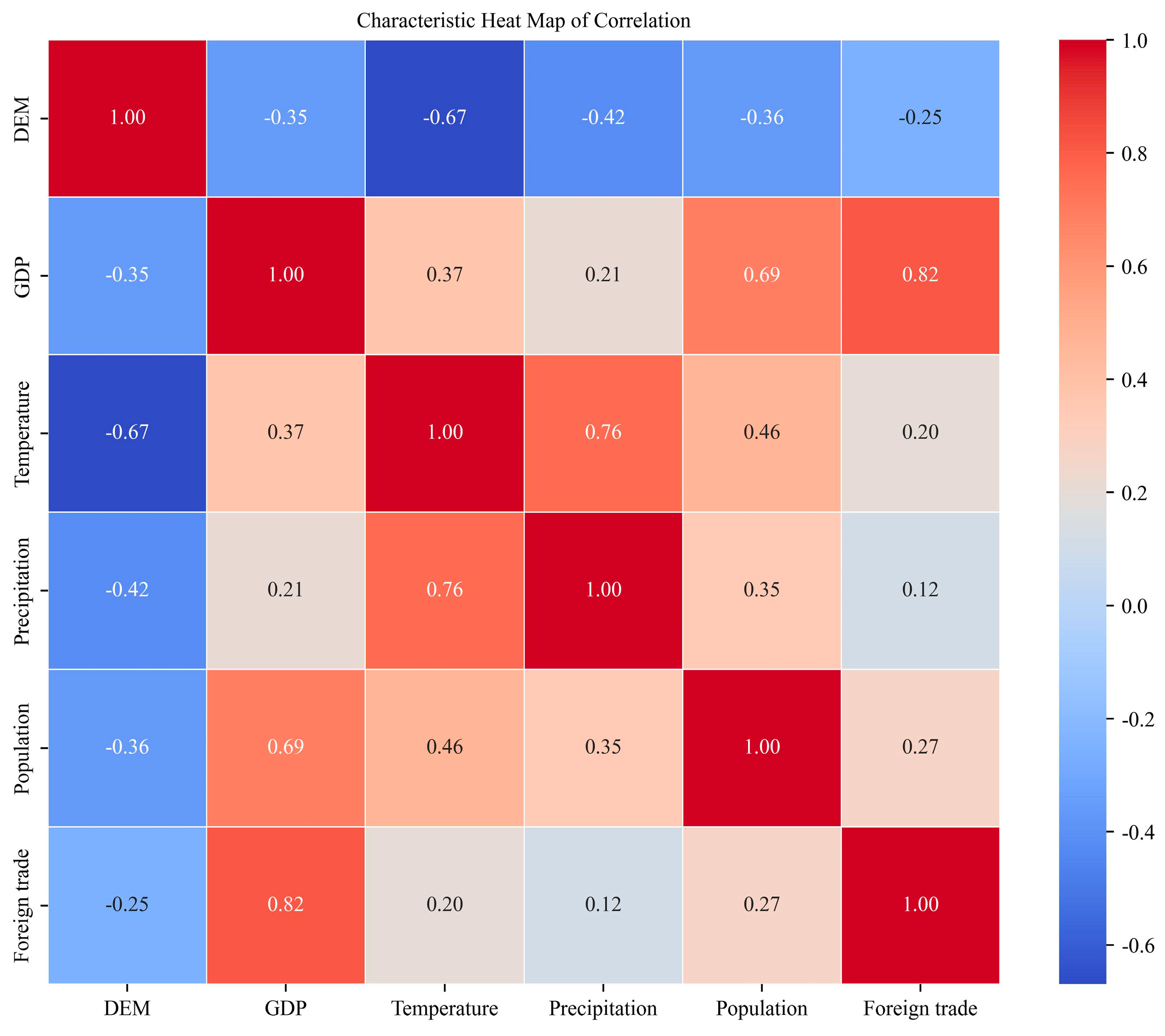
3.1. Analysis of Drivers

We initially included seven candidate variables in the analysis: GDP, GDP per capita, IEV, population, MAT, MAP, and DEM. To avoid multicollinearity, we first conducted an autocorrelation test, whose results are visualized in the heatmap (Figure 2). This test revealed a strong positive correlation between GDP and IEV (r = 0.82, p < 0.001), indicating significant redundancy. Given this collinearity, along with methodological issues such as systematic biases in IEV data (e.g., customs declaration inconsistencies, as noted in Section 2.2.1), IEV was excluded from subsequent analyses.
Figure 2. Heatmap of Pearson correlation coefficients between invasive species counts and environmental/socioeconomic factors. Color gradient from cool colors (negative correlation) to warm colors (positive correlation) indicates the strength and direction of relationships.
Diversity 17 00521 g002
Following the exclusion of IEV, we re-conducted correlation analyses between the remaining six variables and the number of invasive alien plant species. The results (Table 2) showed varying degrees of association, with mean annual temperature (MAT) and annual precipitation (MAP) exhibiting the strongest correlations, confirming their roles as key climatic drivers.
In addition, to account for the effects of urbanization on biological invasions, we constructed an integrated Urbanization Index (UI) representing regional development intensity. The index was derived using principal component analysis (PCA) based on four representative variables: GDP, population, built-up area, and night-time lighting (Figure 3).
The comparison of models and the selected linear regression prediction results are shown (Figure 4).

3.2. Climate Zones

Based on the clustering procedure described in Section 2.2.3, the K-means algorithm grouped provinces into six distinct climate zones using standardized MAT and MAP values. The resulting clusters exhibited strong internal consistency and significant differences in climate characteristics, as confirmed by one-way ANOVA (p < 0.001).
The K-means clustering method ensured objective climate partitioning. Results are shown in Figure 5.

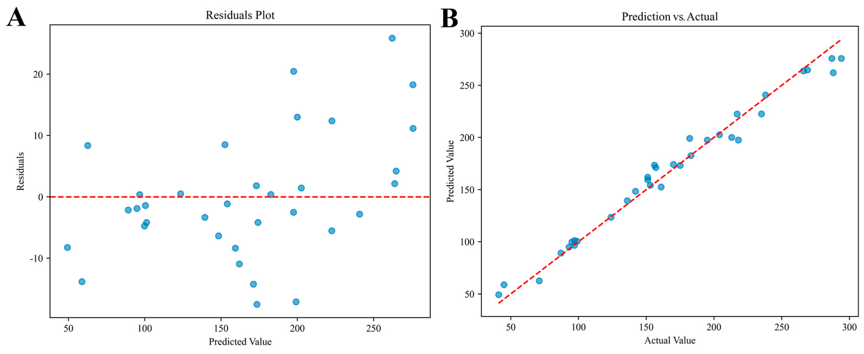
3.3. Ensemble Model Performance

After the integration of the model, the performance of its cross-validated prediction results significantly improved, with the specific data as follows: the MSE was 45.58, the MAE was 5.91, and the R2 reached 0.87, indicating that the model is able to explain 87% of the variance in the number of invasive alien plant species, demonstrating high accuracy. The distribution of prediction errors was relatively uniform across provinces, without any evident systematic bias, which further confirms that the model had strong robustness and generalization performance. Residual plots and regression plots of actual versus predicted values are presented in Figure 6. Additional details are provided in the Supplementary Materials.

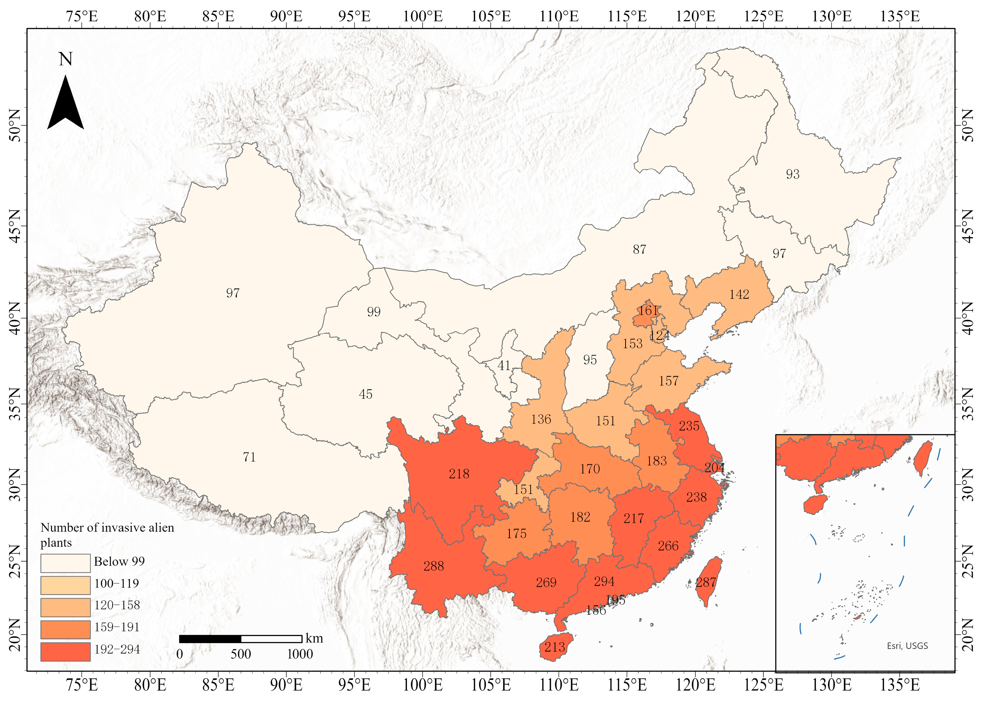
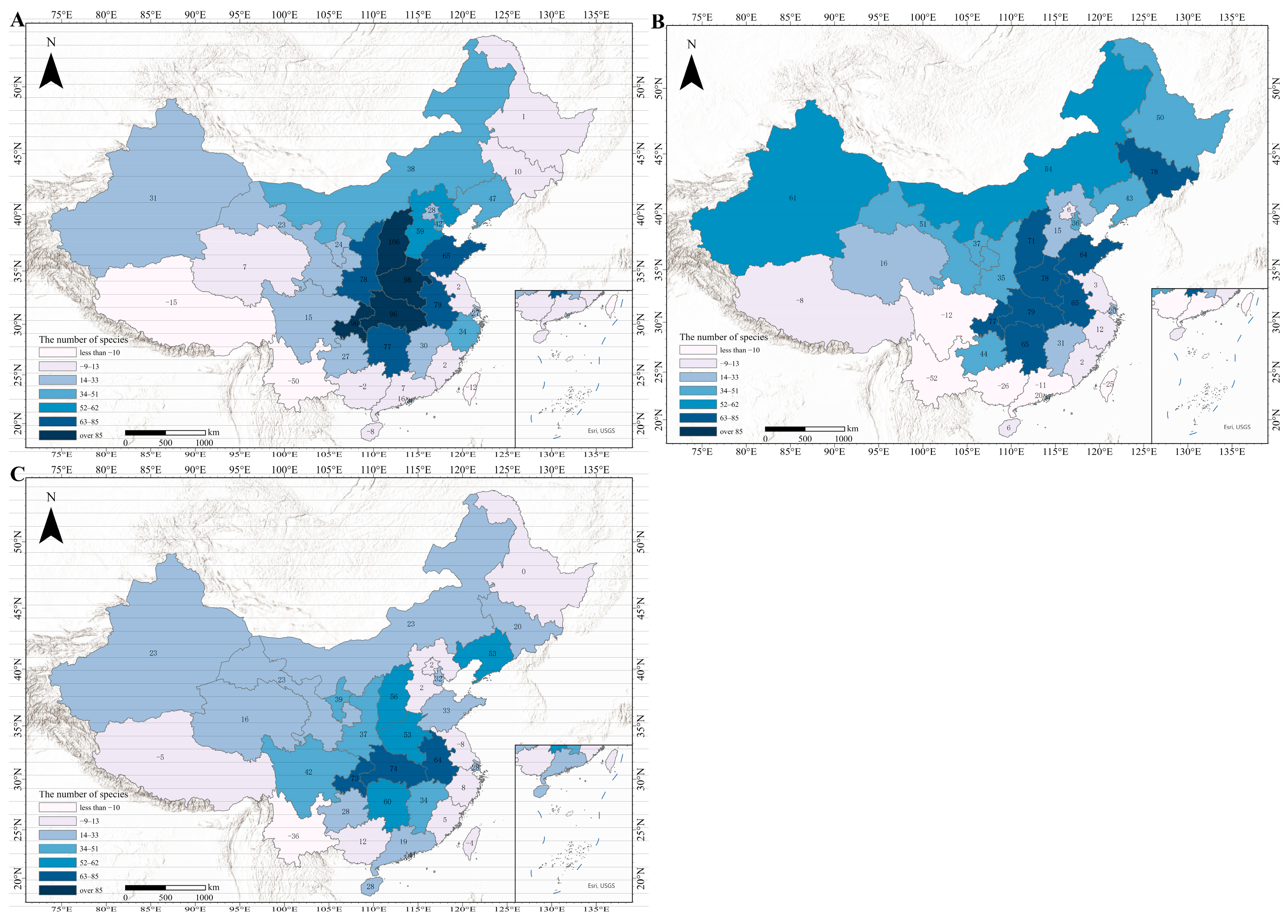
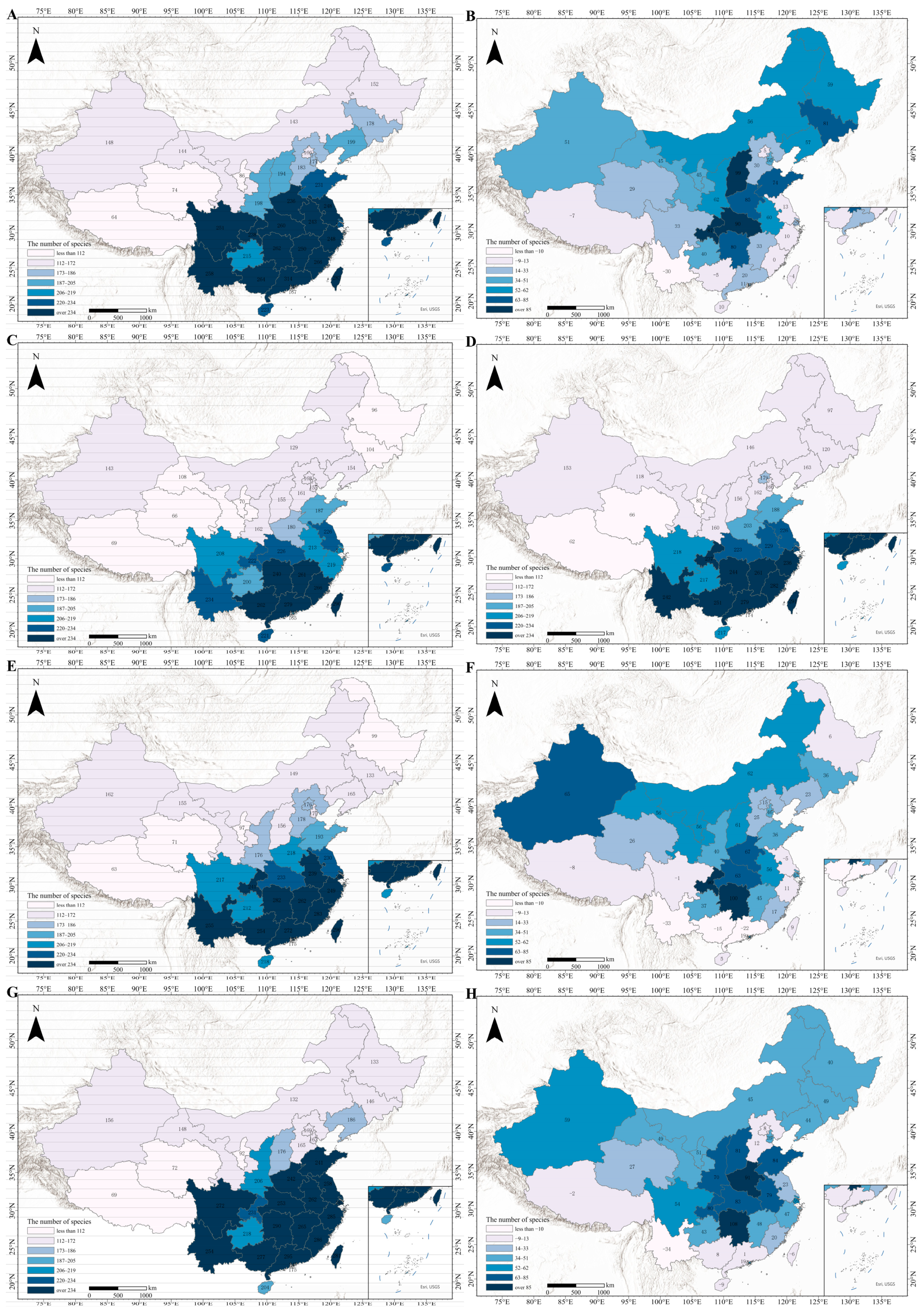
3.4. Status of Species Invasions

Numerous studies have shown that most invasive alien plant species are more likely to establish in anthropogenically disturbed or transformed habitats—such as urban fringes, roadsides, agricultural lands, and degraded ecosystems—rather than in stable, undisturbed native communities. These human-altered areas often provide open ecological niches, reduced biotic resistance, and elevated propagule pressure. In contrast, ecologically intact primary communities tend to exhibit stronger resistance to alien species establishment.
In 2022, invasive alien plant species exhibited distinct provincial-level variations (Figure 7). At a national scale, the southeastern coastal region has become the “hardest-hit” area of invasive alien plants, with the number of invasive species exceeding 200 in several provinces. Among these, Guangdong Province ranks first nationwide with 294 species, followed by Yunnan Province with 288 species; provinces such as Taiwan, Fujian, and Guangxi also have over 260 species. In contrast, northern provinces show significantly lower levels of invasion, with only 41 invasive species in Ningxia Hui Autonomous Region, making it the province least affected by plant invasions nationwide, followed by Qinghai Province with only 45 species, both exhibiting low levels of invasion. This spatial trend shows a clear gradient, gradually decreasing from the southeast coast to the northwest and northeast inland.
This pattern aligns with the classic latitudinal diversity gradient, whereby species richness typically increases toward lower latitudes and decreases toward the poles. Provinces located in subtropical and tropical regions, such as Guangdong and Yunnan, have more alien plant species than provinces in temperate or alpine regions, consistent with global biodiversity distribution patterns.
Regional differences in invasion risk appear closely tied to both climate and human activity. Southeastern coastal regions—characterized by warm, humid climates, dense populations, and rapid economic growth—are particularly susceptible to biological invasions. In contrast, drier, less populated areas with limited trade activity, such as northeastern and northwestern provinces, experience significantly lower invasion pressure [14]. Additionally, in certain provinces, such as parts of Inner Mongolia, Sichuan, and Tibet, large areas of relatively intact native vegetation remain, particularly in forested and mountainous regions. These areas have experienced minimal urbanization or agricultural conversion, thereby retaining higher structural complexity and ecological resilience. In contrast, provinces in the southeastern region have undergone extensive land-use transformations, leading to habitat fragmentation, which has further exacerbated alien plant invasions.
In summary, this phenomenon not only indicates that natural and human factors jointly drive the formation of invasion patterns, but also provides a theoretical basis for developing spatially differentiated management strategies.

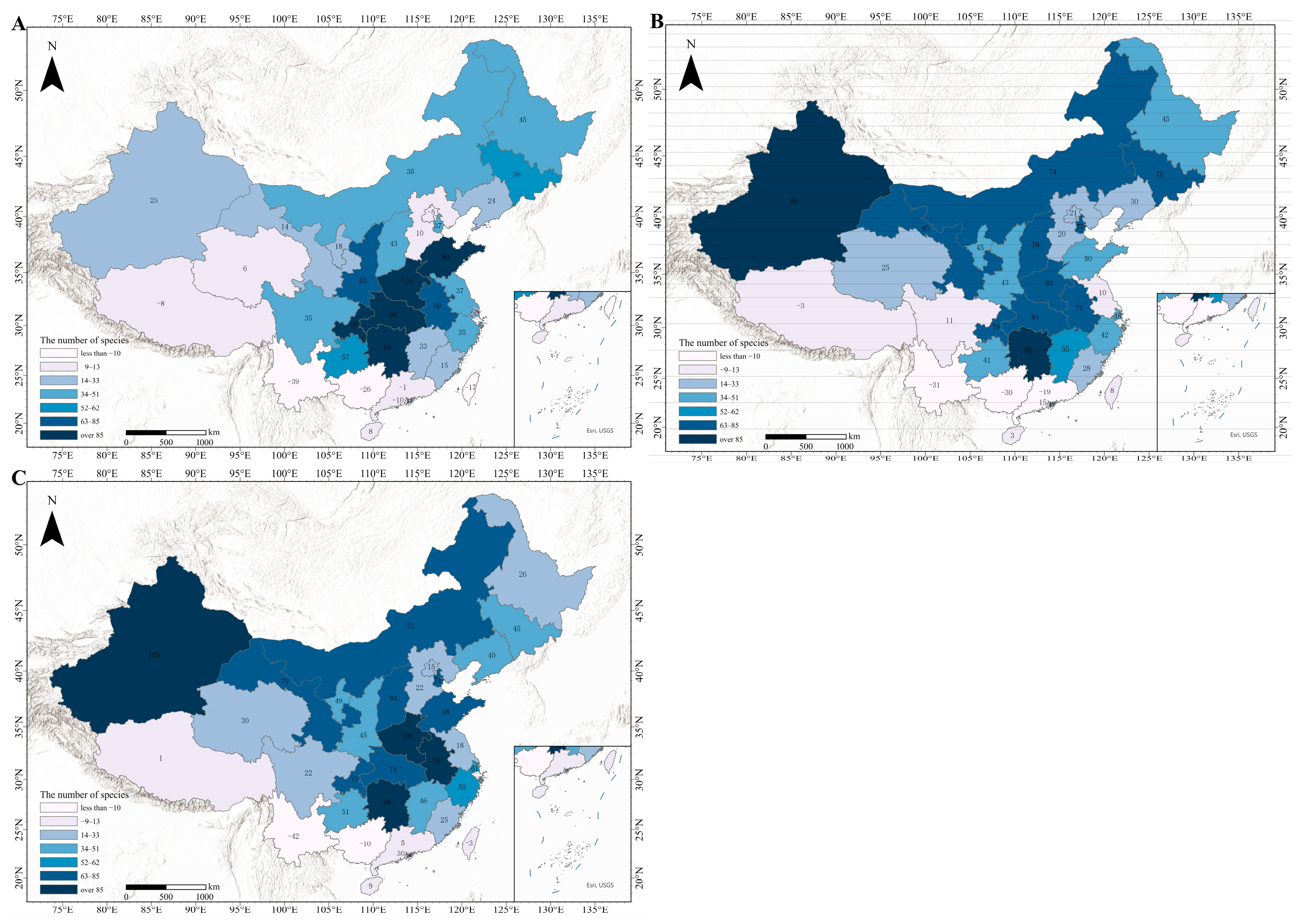
3.5. Overall Change Characteristics

This study integrates multiple climate projection models (EC-Earth3, GFDL-ESM4, and MRI-ESM2-0) with shared socioeconomic pathways (SSPs) using the machine learning model aforementioned.
The results indicate that a significant shift will occur with new hotspots in central and northwest China.
This finding indicates that under the dual influence of climate change and human activities, ecological security hotspots are expanding toward inland areas and ecologically fragile high-latitude regions. The changes are visualized in Figure 8, Figure 9, Figure 10 and Figure 11 and Table 3.
EC-Earth3 predicts greater increases in invasive species under SSP585, while GFDL-ESM4 is more conservative, particularly in coastal areas. MRI-ESM2-0 shows spatial similarity to EC-Earth3 but lower values.
Notably, the results of the three climate models have the smallest differences in the SSP119 scenario and the largest differences in the SSP585 scenario, reflecting that extreme climate change exacerbates the risk of species invasion. For example, under the SSP585, the EC-Earth3 model predicts a national average of 55.6 invasive species, which is higher than the averages under SSP245 (42.3 species) and SSP119 (38.6 species) for the same model.
The predicted increase in the number of invasive alien plant species is not merely a quantitative change; it also implies potential qualitative shifts in local biodiversity. For instance, many of the predicted invasion hotspots (e.g., central China provinces such as Hunan and Henan) are home to a rich assemblage of endemic or narrowly distributed native species. A rapid influx of invasive taxa could lead to biotic homogenization, competitive exclusion, or the displacement of native plant guilds—particularly in fragmented or transitional ecosystems such as agro-pastoral ecotones.
Thus, changes in invasion risk reflect not only the likelihood of increased species counts, but also the vulnerability of local ecological communities to disruption. In arid northwestern provinces, where overall plant diversity is lower and ecosystems are more sensitive to environmental fluctuations, the establishment of invasive species may rapidly destabilize ecological processes such as primary productivity, nutrient cycling, or successional dynamics.

3.6. Regional Variation and Emerging Invasion Hotspots

3.6.1. High-Risk Expansion Zones

At the regional scale, the central region exhibits the most pronounced increasing trend. Hunan, Hubei, Henan, and Jiangxi showed high increases in several model scenarios, suggesting that this region will become a high-risk zone for invasions in the future. These regions also host diverse forest-grassland ecotones and endemic-rich zones, where altered temperature and precipitation regimes may interact with human disturbances to intensify biotic invasions. The introduction of invasive species could result in the decline of local phylogenetic diversity and homogenization of community structures.
Northwest and north China also exhibit an increasing trend across different models. For example, Ningxia and Xinjiang emerged as the provinces with the highest increases nationwide, suggesting that climate change could significantly transform the regional ecosystem structure, thereby creating new ecological niches vulnerable to invasion. This is particularly concerning given that these provinces have low biodiversity and are ecologically fragile. Invasion in such regions may disrupt already stressed trophic networks and introduce novel functional traits that outcompete native desert-adapted flora, altering nutrient cycling and successional processes.
In Northeast China, invasion risks exhibit complex response patterns. For example, Heilongjiang Province had an increase of 50 species in the SSP119 scenario under the GFDL-ESM4 model, but only 1 species under SSP585. Jilin Province exhibited significant growth under SSP119 in both MRI-ESM2-0 (+81 species) and EC-Earth3 (+70 species) simulations. These two provinces exemplify the high uncertainty of invasion risk in the region, which is closely related to differences in data from various climate projection models, with the region being highly sensitive to climate change. This reflects the region’s ecological sensitivity and model-dependent uncertainty, which has implications for conservation planning.

3.6.2. Decreasing or Stabilizing Regions

Yunnan and Tibet exhibit a decreasing trend in almost all models and scenarios. This trend in both regions is driven by highly consistent factors, primarily the projected decline in population in future years. Especially in Yunnan Province, the population is projected to decrease by over 2 million in 2030 and 2040 compared to 2022, and to reach a decline of 3 million in 2050, and this sharp demographic decline directly contributes to Yunnan being the only province with decreasing invasive species across all scenarios and models. Tibet’s population decline is less pronounced than Yunnan’s, on the order of several hundred thousand, but its alpine ecosystem is also an important factor in the decline of its species numbers—lower temperatures and less precipitation in the coming years. However, such trends should not be misinterpreted as indicating low ecological risk. These regions possess high endemism and ecological specialization, especially Tibet’s alpine meadows, where even slight changes in community structure may trigger cascading biodiversity losses.
The trend in the southeastern coastal region is more complex, primarily due to precipitation variability. For example, it is 2200 mm in Guangdong under MRI-ESM2-0 SSP119 but only 1600 mm in the SSP245, a difference of more than 600 mm. This difference is comparable to the total annual precipitation in Hebei and Shanxi (about 700 mm). This large difference in precipitation leads to the observed phenomenon.
Hong Kong, Macao, and Taiwan exhibit high instability. For example, in Macao, the number of invasive species increased by 30 species under the EC-Earth3 SSP585 scenario but only by 3 species under the GFDL-ESM4 SSP245 scenario—significant fluctuations directly related to its small geographic size and the large spatial scale of climate data. Hong Kong and Taiwan showed a certain degree of increase or decrease, and the analysis of the reasons for this is related to urbanization data. However, the causes in each region are different. In Hong Kong, its small geographic area has led to the saturation of urbanization, while in Taiwan, there is a downward trend in urbanization data in the coming years. Considering the combined effects of other factors, this results in fluctuations in the data for both regions, demonstrating a strong sensitivity to exogenous shocks.

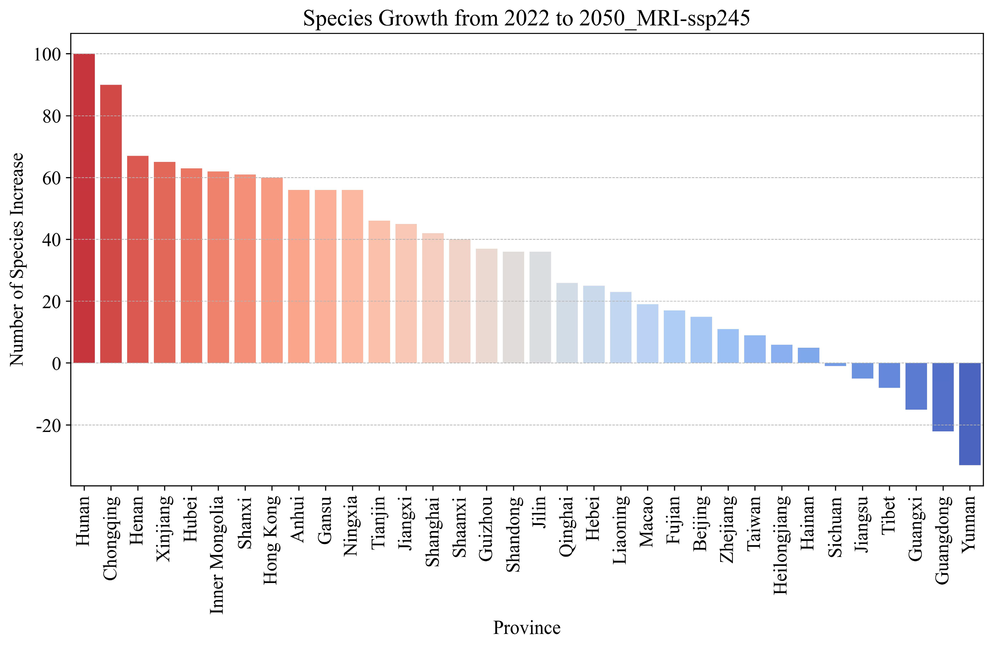
3.7. In-Depth Analysis of the SSP245 Scenario Based on MRI-ESM2-0 Modeling

Among the three climate models applied in this study, EC-Earth3 is notably sensitive to rising greenhouse gas concentrations, particularly carbon dioxide (CO2). It effectively captures the compounded effects of extreme climatic events—such as heatwaves and heavy rainfall—and anthropogenic disturbances like urbanization and trade expansion. These features make it well-suited for modeling high-intensity disturbance scenarios. However, it may overestimate climatic effects in transitional zones such as temperate semi-arid regions, where ecological responses are more variable.
GFDL-ESM4, in contrast, emphasizes long-term carbon–climate feedbacks and characterizes anthropogenic pressure primarily through land-use transitions (e.g., urban sprawl). While suitable for simulating broad-scale ecosystem dynamics, it is less responsive to dynamic human activity indicators, such as nighttime lighting or infrastructure development, and may underrepresent localized invasion dynamics.
MRI-ESM2-0 offers a more balanced approach by combining moderate CO2-induced physiological responses with spatially heterogeneous socioeconomic variables—including provincial-level GDP and population density—allowing for finer-scale differentiation. Its projections align well with the coupled trajectory of carbon mitigation and economic restructuring observed in China, making it the most plausible and regionally interpretable model.
Furthermore, the medium-emission SSP245 scenario shows invasive species expansion with moderate growth and no extreme jumps in most areas, making it the most realistic reference among models.
Therefore, considering the characteristics of both the scenario and the model, this study focuses on analyzing the SSP245 scenario under the MRI-ESM2-0 model. This choice enables a more realistic analysis of the complex characteristics and underlying mechanisms of changes in the number of invasive alien plant species across different regions of China, with the analysis conducted based on the six climate zone types defined in Section 3.3.
Temperate semi-arid zone (Climate Zone 0): This region includes Gansu, Heilongjiang, Jilin, Liaoning, Inner Mongolia, Sichuan, and Xinjiang. With mean annual temperatures ~6 °C and precipitation ~630 mm, this region experiences significant warming (+1.5–2.0 °C), resulting in generally slow but steady growth in invasive species. Xinjiang is an exception, where >2.2 °C warming drives a +60-species surge despite its cold, dry baseline.
Subtropical humid zone (Climate Zone 1): This region includes Fujian, Guangxi, Hunan, Jiangxi, and Zhejiang (18–20 °C and 1500–1600 mm precipitation). The warm, humid conditions favor invasive species, leading to consistent growth (e.g., Hunan’s increase from 80 to 108 species, +28 species) that intensifies competition with native species. Dense native plant communities may face structural shifts due to altered recruitment and growth dynamics, with potential loss of functional diversity.
Temperate humid zone (Climate Zone 2): This region covers nine provinces and cities, including Anhui, Chongqing, Guizhou, Henan, Hubei, Jiangsu, Shandong, Shanghai, and Yunnan. It is one of the regions with the most pronounced species growth under this scenario model. Between 2022 and 2050, mean annual temperature and annual precipitation increase slightly. Additionally, socioeconomic factors in the region, show sustained growth, for example, the GDP of Henan Province is projected to reach CNY 14.9 trillion in 2050, and the urbanization rate (UI) is expected to increase to 0.69. Such transformation may create urban-wildland edges that serve as corridors for invasive species spread, undermining peri-urban biodiversity. Under the combined influence of these factors, the number of invasive species exhibits a marked increase in the region.
Tropical maritime humid zone (Climate Zone 3): This region includes Guangdong, Hainan, Hong Kong, Macao, and Taiwan. With mean annual temperatures >22 °C and precipitation >2000 mm, this region’s hydrothermal advantages intensify under the scenario (e.g., Guangdong reaching ~25 °C and 2200 mm precipitation). These conditions exacerbate thermal stress and drive the fluctuating changes in invasive species detailed in Section 3.6.1.
Plateau cold and arid zone (Climate Zone 4): This region includes Qinghai and Tibet. The mean annual temperature is below 0 °C, annual precipitation is less than 500 mm, and the average altitude exceeds 4000 m. The temperature increases in this region will be more pronounced by 2050, for example, Qinghai’s mean annual temperature is projected to rise to ~2.5 °C. However, the precipitation shows a slight downward trend (less than 400 mm in 2050). Therefore, under the combined effect of these two factors, the number of species in Qinghai Province will increase, though not significantly. These conditions, combined with the demographic factors noted earlier, will result in a small decrease in the number of species in Tibet.
Temperate semi-humid zone (Climate Zone 5): This region includes Beijing, Hebei, Ningxia, Shaanxi, Shanxi, and Tianjin (~11 °C and ~700 mm precipitation). The combination of moderate growth and high habitat connectivity facilitates rapid ecological community turnover (e.g., +60 species in Shanxi, +40 in Shaanxi under SSP245).
In conclusion, the problem of invasive alien plants in Chinese provinces is characterized by a complex spatial and temporal distribution, which is driven by natural factors such as precipitation and temperature, as well as anthropogenic factors such as socioeconomic development and population size. The differences in invasive species changes between regions have widened to different degrees under different scenarios, suggesting that future prevention and control strategies should be adapted to local conditions and dynamically adjusted. At the same time, invasion risk monitoring should be strengthened in high-growth regions. Vigilance should also be maintained in low-risk areas to prevent them from becoming high-risk.

4. Discussion

Our results highlight a marked spatial shift in the hotspots of invasive alien plant species under future climate and socioeconomic scenarios, with increasing invasion risk projected for inland and high-latitude regions. These changes are not random but follow predictable ecological and anthropogenic gradients.
First, the increased risk of invasion in central and northwestern China—regions such as Ningxia and Xinjiang, currently with low species numbers and harsh climates, may become more suitable for invasive species due to rising temperatures and increased precipitation, thereby reducing the physical barriers to colonization. This aligns with Pan et al. [66], who observed that low-diversity habitats subject to frequent disturbance are more susceptible to invasion due to reduced biotic resistance.
Second, socioeconomic drivers, particularly urbanization and GDP growth, appear to be strong drivers of species dispersal. Highly urbanized areas often face habitat fragmentation, microclimate changes, and increased trade and transportation networks, which exacerbate dispersal pressures and facilitate the successful establishment of invasive species. This aligns with the “urban expansion-driven hypothesis” proposed by Boscutti et al. For instance, in Henan Province, under the EC-Earth3 model SSP585 scenario, the increase of 100 invasive plant species is not only due to rising mean annual temperatures (+2.0 °C) and increased precipitation (+8%), but also closely linked to the surge in urbanization rate (UI) from 2.03 to 3.41.
Additionally, the observed reduction or stability in species numbers in the Qinghai-Tibet Plateau region does not necessarily imply ecosystem safety or resilience. Rather, this pattern may be attributed to demographic shifts or limitations in model predictive accuracy. Ecosystems in these regions are extremely fragile—even with few invasive species, low ecological resilience could lead to irreversible damage. This mismatch between predicted species numbers and underlying ecological vulnerability underscores the need to focus not only on species numbers but also on their potential ecological impacts.
It is worth noting that there are differences in the outputs of different climate models (such as EC-Earth3 and GFDL-ESM4), which are particularly significant under extreme scenarios (SSP585). This reflects the uncertainties arising from climate model structures, input assumptions, and downscaling methods, which propagate to predictions of species distribution.
Despite the insights gained from the above analysis, this study, like any modeling work, is not without limitations. Specifically, the theoretical and methodological constraints of the model warrant further discussion.

4.1. Theoretical Limitations

4.1.1. Model Constraints

Although the current integrated model achieves satisfactory prediction accuracy (R2 = 0.87), it remains a static representation reliant on limited factors. Importantly, it fails to account for biotic interactions and ecological feedbacks, particularly in biodiversity hotspots with complex ecosystems. For example, invasive plants may establish facilitative interactions with co-introduced herbivores, fungi, or pathogens, potentially suppressing native species and enhancing invasion success. Such facilitative interactions may magnify invasion impacts, yielding outcomes that exceed predictions based solely on abiotic factors. Therefore, subsequent investigations could incorporate multifactorial analyses, such as integrating population dynamic models (e.g., Lotka-Volterra equations) to simulate resource competition processes between invasive and native species, which would better capture the ecosystem’s feedback regulation mechanisms. Integrating species-specific interaction data would improve model robustness, allowing for more accurate quantification of these ecological feedbacks.
Additionally, finer-scale human intervention data are absent, which affects prediction accuracy. For example, in recent years, Guangdong has strengthened its port quarantine and ecological restoration projects, as well as public awareness of ecological security issues. These factors clearly impact species invasion but are not captured by the model, a limitation that naturally affects the results. This therefore suggests that social factors such as policy implementation need to be incorporated into the prediction framework in the future to obtain more accurate predictions.
Furthermore, the current model does not include species introduction and dispersal pathways, such as ports, airports, road networks, or the ornamental plant trade. These anthropogenic factors often circumvent environmental filters and play a decisive role in determining the timing and location of invasions. For example, regions like Guangdong and Shanghai not only have suitable climates and high levels of urbanization, but also serve as international trade hubs with dense transportation infrastructure and frequent imports of ornamental plants. The absence of such variables in the current model may lead to spatial prediction biases, such as overestimating the risk in regions with suitable climates but limited logistics infrastructure.

4.1.2. Spatial Scale Limitations

The study uses provincial administrative regions as the units of analysis, which is too large a scale to accurately assess the actual risk of invasion across diverse sub-regions within a province. There are often significant differences in topography, climate, vegetation cover, etc., within the same province; the most typical examples being the Daxing’anling forests in the east of Inner Mongolia (Mengdong), the Hulunbeier grasslands versus the Alashan Desert in the west of Inner Mongolia (Mengxi), or the highland mountains in the Kamba region of Sichuan Province versus the Sichuan Basin. In addition, behind these differentiated land cover types are climatic differences, and a comprehensive and generalized division into a provincial unit for analysis may lead to a lack of specificity in the development of prevention and control strategies. Therefore, future studies need to use higher resolution data (e.g., 1 km grids) for smaller scale studies to improve the fineness and accuracy of the prediction results and provide strong support for prevention and control decisions.

4.2. Future Perspectives and Management Implications

4.2.1. Research Priorities

Constructing multi-factor composite models. Current models primarily rely on natural variables (e.g., temperature, precipitation), and socioeconomic variables (e.g., population, GDP) as predictive drivers, but the actual invasion process is more complex, with additional factors—beyond those mentioned—also playing important roles. Land-use changes (e.g., soil desertification, urban expansion, and agricultural land conversions between croplands and forests) directly alter species habitats, thereby influencing invasion risks. However, this study did not incorporate these factors, potentially leading to risk assessment biases—particularly in fine-scale future analyses. Therefore, future prediction frameworks should aim to construct higher-dimensional composite models.
Enhancing spatiotemporal accuracy. Beyond the model itself, long-term time series of invasion data can help better identify the long-term dynamics of alien plant invasion and the long-term effects of various drivers. A limitation of the existing model is the short time scale of species count data, which is only available for 2022. Therefore, in future studies, if more comprehensive and representative long-term data become available, the model can be further optimized and its prediction accuracy will be improved. In terms of spatial scale, the current study area can only go up to the provincial scale, such as the central and western provinces, which are too large and have too many regional differences, and the current study does not effectively incorporate more refined climate zones or detailed economic and demographic data than those described in Section 4.1. Therefore, more detailed data will more accurately capture the unique ecological and socioeconomic characteristics of different regions (at the city and county scales) and improve the accuracy of the results.

4.2.2. Management Recommendations

Develop a regional differentiation strategy. Fully consider the results of the previous risk assessment (Section 4.2.1; ②), and tailor strategies to regional risks through a unified framework with localized measures. For example, in regions with favorable climatic conditions but high species fluctuations (e.g., Guangdong and Yunnan), the risk of alien plant invasion should be reduced by strengthening the resistance of native ecosystems, leveraging the diversity of local ecosystems [66].
Strengthen policy simulation and scenario analysis. Similar to climate data analysis under different SSPs (SSP119, SSP245, SSP585), management studies should conduct multi-scenario simulations of prevention and control policies, use policy simulation models to assess the effects of implementing different policy measures, and assess in depth the impacts of different levels of policies on the future pathways of species expansion, in order to provide a more targeted scientific basis for decision-making, and achieve effective control of invasive alien plant risks.
Interdisciplinary synergy and social participation.
(i)
Addressing spatial mismatch. According to the trend of “ecological hotspots” shifting to central and northwestern China, reconfigure the layout of the monitoring network, and adopt a monitoring mode that combines policy and technological approaches, supplemented by manpower and machines.
(ii)
Incorporating invasion pathway-related factors. Include predictor variables and detailed data on introduction pathways (e.g., port interception records, nursery trade volumes, transportation corridors).
(iii)
Developing scenario-specific strategies. Develop targeted prevention and control strategies according to risk differences in climatic regions and the ecological habits of invasive species.
(iv)
Balancing ecosystem resilience. In regions like the Tibetan Plateau with “natural barriers,” monitoring intensity should be carefully calibrated.

5. Conclusions

This study analyzes various socioeconomic factors and the simulation results of multiple climate models to characterize the spatiotemporal dynamics of invasive plant species in China. The findings indicate that central and northwestern regions will face higher invasion risks in the future, which contrasts significantly with the original spatial pattern of invasion risk, thereby decreasing from the southeastern coast to the northwestern and northeastern inland areas.
The driving mechanisms behind this trend include increased temperatures and precipitation in arid regions, which improve the survival conditions for invasive species; urban expansion, which causes habitat fragmentation and thus increases pathways for species introduction; and economic growth, which facilitates species dispersal through intensified human activities. The synergistic effects of these factors not only provide new ecological niches for invasive species, but also weaken the ecological resilience of native ecosystems, ultimately facilitating successful invasions. Notably, this study indicates that even in regions where the number of invasive species is expected to decrease (e.g., Qinghai-Tibet Plateau region), ecological vulnerability warrants attention. These regions are home to a large number of endemic species, and their ecosystems exhibit low ecological resilience and limited tolerance to external disturbances. Therefore, future management strategies must incorporate both quantitative assessments of invasion risks and qualitative analyses of ecological sensitivity.
In the MRI-ESM2-0 model, the prediction results for the SSP245 scenario exhibit the most spatially balanced projections. This finding emphasizes the need to formulate region-specific management strategies for different climate zones, which can provide a scientific basis for the effective control of invasive plants (e.g., formulation of management plans and the improvement of relevant regulations).
Due to limitations in climate models and spatial scales, the prediction results of this study cannot fully represent future trends and require further refinement.
In summary, the prevention and management of invasive plant species require not only interdisciplinary integration of ecology and social sciences, but also the coordination of multi-dimensional research methods. The comprehensive modeling and prediction framework proposed in this study holds significant value for future research on invasion trends. However, it is important to note that the application of scientific findings into policy practice is hindered by objective factors such as data fragmentation and insufficient interdepartmental coordination. Therefore, research efforts must be sustained and expanded.

Supplementary Materials

The following supporting information can be downloaded at: https://www.mdpi.com/article/10.3390/d17080521/s1. CODE: Python scripts for data preprocessing, modeling, and visualization. DATA: Key datasets including environmental variables and spatial data. README: Instructions for reproducing the analysis and using the files.

Author Contributions

Conceptualization, Y.C. and X.N.; Methodology, Y.C., X.N., Z.J., Y.S. and X.B.; Software, Y.C., X.N., Z.J., Y.S. and X.B.; Validation, Y.C. and X.N.; Formal analysis, Y.C. and X.N.; Data curation, Y.C., X.N., Z.J. and Y.S.; Writing—original draft preparation, Y.C.; Writing—review and editing, Y.C., X.N. and Z.J.; Visualization, Y.C.; Supervision, Y.C. and X.N.; Funding acquisition, X.N. All authors have read and agreed to the published version of the manuscript.

Funding

This study was partially funded by the Inner Mongolia Science and Technology Major Project (Grant No. 2021ZD0011). This work was also supported by the Inner Mongolia University High Level Talent Research Startup Project (Grant No. 21800-5215105).

Institutional Review Board Statement

Not applicable.

Data Availability Statement

Data available on request from the authors.

Conflicts of Interest

The authors declare no conflicts of interest.

References

  1. Lloyd, M.C.; Gatenby, R.A.; Brown, J.S. Chapter 11-Ecology of the Metastatic Process. In Ecology and Evolution of Cancer; Ujvari, B., Roche, B., Thomas, F., Eds.; Academic Press: Cambridge, MA, USA, 2017; pp. 153–165. ISBN 978-0-12-804310-3. [Google Scholar] [CrossRef]
  2. Institute of Botany, Chinese Academy of Sciences. China Invasive Alien Species Information System. Available online: https://www.iplant.cn/ias/ (accessed on 15 October 2023).
  3. Wang, F. Historical, Impact, and Countermeasure Research on Invasive Alien Species. Stud. Dialect. Nat. 2005, 21, 5. [Google Scholar] [CrossRef]
  4. Liu, X.; Huang, W.; Liu, Y.; Zhan, A. Perspectives of Invasive Alien Species Management in China. Ecol. Appl. 2024, 34, e2926. [Google Scholar] [CrossRef]
  5. Qin, F.; Xue, T.T.; Liang, Y.F.; Zhang, W.; Liu, Q.; Chen, T.; Yu, S. Present Status, Future Trends, and Control Strategies of Invasive Alien Plants in China Affected by Human Activities and Climate Change. Ecography 2023, 2024, e06919. [Google Scholar] [CrossRef]
  6. Diagne, C.; Leroy, B.; Vaissière, A.C.; Gozlan, R.E.; Roiz, D.; Jarić, I.; Salles, J.M.; Bradshaw, C.J.A.; Courchamp, F. High and Rising Economic Costs of Biological Invasions Worldwide. Nature 2021, 592, 571–576. [Google Scholar] [CrossRef]
  7. Yang, Q.; Ye, W.; Deng, X.; Xu, K. Characteristics and Hazards of Invasive Alien Plants in China. Ecol. Sci. 2002, 21, 6. [Google Scholar] [CrossRef]
  8. Yan, X.; Zhenyu, L.; Gregg, W.P.; Dianmo, L. Invasive Species in China–An Overview. Biodivers. Conserv. 2001, 10, 1317–1341. [Google Scholar] [CrossRef]
  9. Wan, F.-H.; Guo, J.-Y.; Wang, D.-H. Alien Invasive Species in China: Their Damages and Management Strategies. Biodiv. Sci. 2002, 10, 119–125. [Google Scholar] [CrossRef]
  10. Guo, K.; Pyek, P.; Van Kleunen, M.; Kinlock, N.L.; Lučanová, M.; Leitch, I.J.; Pierce, S.; Dawson, W.; Essl, F.; Kreft, H.; et al. Plant Invasion and Naturalization Are Influenced by Genome Size, Ecology and Economic Use Globally. Nat. Commun. 2024, 15, 1330. [Google Scholar] [CrossRef]
  11. Ju, R.; Li, H.; Shih, C.; Li, B. Progress of Biological Invasions Research in China over the Last Decade. Biodiv. Sci. 2012, 20, 581–611. [Google Scholar] [CrossRef]
  12. Jiang, Q.; Yao, W. Preliminary Establishment of a Risk Assessment Index System for Harmful Organisms. Plant Quar. 1994, 8, 4. [Google Scholar]
  13. Chen, X.-L.; Ning, D.-D.; Xiao, Q.; Jiang, Q.-Y.; Lu, Y.-Y.; Xu, Y.-J. Factors Affecting the Geographical Distribution of Invasive Species in China. J. Integr. Agric. 2022, 21, 1116–1125. [Google Scholar] [CrossRef]
  14. Chen, J.; Ma, F.; Zhang, Y.; Wang, C.; Xu, H. Spatial Distribution Patterns of Invasive Alien Species in China. Glob. Ecol. Conserv. 2021, 26, e01432. [Google Scholar] [CrossRef]
  15. Ministry of Ecology and Environment of the People’s Republic of China. Notice on the Release of the First List of Invasive Alien Species in China: Huanfa [2003] No. 11. Available online: https://www.mee.gov.cn/gkml/zj/wj/200910/t20091022_172155.htm (accessed on 31 July 2024).
  16. Korniss, G.; Caraco, T. Spatial Dynamics of Invasion: The Geometry of Introduced Species. J. Theor. Biol. 2005, 233, 137–150. [Google Scholar] [CrossRef]
  17. Yang, C.; Han, C. Assessment of Economic Losses Caused by Invasive Alien Species. Environ. Prot. 2005, 13, 13–17. [Google Scholar] [CrossRef]
  18. Born, W.; Rauschmayer, F.; Bräuer, I. Economic Evaluation of Biological Invasions—A Survey. Ecol. Econ. 2005, 55, 321–336. [Google Scholar] [CrossRef]
  19. Wang, Y.; Wan, F.; Shen, J. Quantitative Models and Applications for Risk Assessment of Invasive Alien Species. Acta Entomol. Sin. 2007, 50, 512–520. [Google Scholar] [CrossRef]
  20. Wang, Y.; Xie, B.; Wan, F.; Xiao, M.; Dai, L. Application of ROC Curve Analysis in Evaluating Distribution Models of Invasive Species. Biodiversity 2007, 15, 8. [Google Scholar] [CrossRef]
  21. Chen, H.; Chen, L. Predicting the Potential Distribution of Invasive Exotic Species Using GIS and Remote Sensing. J. Remote Sens. 2007, 11, 426–432. [Google Scholar] [CrossRef]
  22. Zhang, Y.; Lu, J. Research Progress on Remote Sensing Monitoring of Invasive Alien Species Spartina alterniflora and Eichhornia crassipes. Sci. Technol. Bull. 2010, 1, 8. [Google Scholar] [CrossRef]
  23. Hao, C.; Lijun, C.; Albright, T.P. Predicting the Potential Distribution of Invasive Exotic Species Using GIS and Information-Theoretic Approaches: A Case of Ragweed (Ambrosia artemisiifolia L.) Distribution in China. Chin. Sci. Bull. 2007, 52, 8. [Google Scholar] [CrossRef]
  24. Xu, H.; Qiang, S.; Han, Z.; Guo, J.; Huang, Z.; Sun, H.; He, S.; Ding, H.; Wu, H.; Wan, F. The Status and Causes of Alien Species Invasion in China. Biodivers. Conserv. 2006, 15, 2893–2904. [Google Scholar] [CrossRef]
  25. Ministry of Ecology and Environment of the People’s Republic of China. Notice on the Release of the Second List of Invasive Alien Species in China: Huanfa 2010. No. 4. Available online: https://www.mee.gov.cn/gkml/hbb/bwj/201001/t20100126_184831.htm (accessed on 1 August 2024).
  26. Ministry of Ecology and Environment of the People’s Republic of China. Announcement on the Release of the Third List of Invasive Alien Species in China: Announcement 2014 No. 57. Available online: https://www.mee.gov.cn/gkml/hbb/bgg/201408/t20140828_288367.htm (accessed on 1 August 2024).
  27. Ministry of Ecology and Environment of the People’s Republic of China. Announcement on the Release of the Fourth List of Invasive Alien Species in China’s Natural Ecosystems: Announcement 2016 No. 78. Available online: https://www.mee.gov.cn/gkml/hbb/bgg/201612/t20161226_373636.htm (accessed on 1 August 2024).
  28. Ma, J.; Li, H. The Checklist of the Alien Invasive Plants in China; Higher Education Press: Beijing, China, 2018; 299p, ISBN 978-7-04-048875-3. [Google Scholar]
  29. Luquan, W. Current Situation and Future of Legislation on Precaution of Alien Species Invasion in China. In Biodiversity Laws, Policies and Science in Europe, the United States and China; Antonelli, G., Qin, T., Ferroni, M.V., Erwin, A., Eds.; Springer: Cham, Switzerland, 2024; pp. 1–16. [Google Scholar] [CrossRef]
  30. Liu, J.; Liang, S.-C.; Liu, F.-H.; Wang, R.-Q.; Dong, M. Invasive Alien Plant Species in China: Regional Distribution Patterns. J. Ecol. 2005, 11, 341–347. [Google Scholar] [CrossRef]
  31. Zhou, Q.; Wang, Y.; Li, X.; Liu, Z.; Wu, J.; Musa, A.; Ma, Q.; Yu, H.; Cui, X.; Wang, L. Geographical Distribution and Determining Factors of Different Invasive Ranks of Alien Species across China. Sci. Total Environ. 2020, 722, 137929. [Google Scholar] [CrossRef]
  32. Yan, X.; Liu, Q.; Shou, H.; Zeng, X.; Zhang, Y.; Chen, L.; Liu, Y.; Ma, H.; Qi, S.; Ma, J. The Categorization and Analysis on the Geographic Distribution Patterns of Chinese Alien Invasive Plants. Biodivers. Sci. 2014, 22, 667. [Google Scholar] [CrossRef]
  33. Xu, H.G.; Qiang, S. Invasive Alien Species in China, Revised ed.; Science Press: Beijing, China, 2018; 299p, ISBN 978-7-04-048875-3. [Google Scholar]
  34. Ministry of Agriculture and Rural Affairs, Ministry of Natural Resources, Ministry of Ecology and Environment, General Administration of Customs. Measures for the Management of Invasive Alien Species: Ministry of Agriculture and Rural Affairs Order 2022. No. 4. Available online: https://www.gov.cn/zhengce/zhengceku/2022-06/17/content_5696171.htm (accessed on 1 August 2024).
  35. National Plant Specimen Resource Center. Checklist of Invasive and Naturalized Plants in China, 2023 Edition. Available online: https://www.cvh.ac.cn/iapc/ (accessed on 1 August 2024).
  36. Pyšek, P.; Hulme, P.E.; Simberloff, D.; Bacher, S.; Blackburn, T.M.; Carlton, J.T.; Dawson, W.; Essl, F.; Foxcroft, L.C.; Genovesi, P.; et al. Scientists’ warning on invasive alien species. Biol. Rev. 2020, 95, 1511–1534. [Google Scholar] [CrossRef]
  37. Tu, W.; Xiong, Q.; Qiu, X.; Zhang, Y. Dynamics of invasive alien plant species in China under climate change scenarios. Ecol. Indic. 2021, 129, 107919. [Google Scholar] [CrossRef]
  38. Gallien, L.; Douzet, R.; Pratte, S.; Zimmermann, N.E.; Thuiller, W. Invasive species distribution models–how violating the equilibrium assumption can create new insights. Glob. Ecol. Biogeogr. 2012, 21, 1126–1136. [Google Scholar] [CrossRef]
  39. Yang, M.; Zhao, H.; Xian, X.; Wang, R.; Yang, N.; Chen, L.; Liu, W. Assessing risk from invasive alien plants in China: Reconstructing invasion history and estimating distribution patterns of Lolium temulentum and Aegilops tauschii. Front. Plant Sci. 2023, 14, 1113567. [Google Scholar] [CrossRef]
  40. GEBCO Compilation Group. GEBCO 2023 Grid. 2023. Available online: https://doi.org/10.5285/f98b053b-0cbc-6c23-e053-6c86abc0af7b (accessed on 1 May 2024).
  41. National Centers for Environmental Information. Global Summary of the Day. NOAA. Available online: https://www.ncei.noaa.gov/data/global-summary-of-the-day/archive/ (accessed on 1 August 2024).
  42. Muñoz Sabater, J. ERA5-Land Monthly Averaged Data from 1950 to Present. Copernicus Climate Change Service (C3S) Climate Data Store (CDS). 2019. Available online: https://cds.climate.copernicus.eu/cdsapp#!/dataset/reanalysis-era5-land-monthly-means?tab=overview (accessed on 1 May 2024).
  43. Peng, S.; Ding, Y.; Liu, W.; Li, Z. 1 km Monthly Temperature and Precipitation Dataset for China from 1901 to 2017. Earth Syst. Sci. Data 2019, 11, 1931–1946. [Google Scholar] [CrossRef]
  44. National Bureau of Statistics. China City Statistical Yearbook; China Statistics Press: Beijing, China, 2000–2023. Available online: https://www.stats.gov.cn/english/Statisticaldata/yearbook/ (accessed on 1 August 2024).
  45. Tong, J.; Su, B.; Jing, C.; Wang, Y.; Huang, J.; Guo, H.; Yang, Y.; Wang, G. Yong Luo National and Provincial Population and Economy Projection Databases under Shared Socioeconomic Pathways (SSP1-5)_v2. Sci. Data Bank 2024. [Google Scholar] [CrossRef]
  46. Chen, Y.; Guo, F.; Wang, J.; Cai, W.; Wang, C.; Wang, K. Provincial and Gridded Population Projection for China under Shared Socioeconomic Pathways from 2010 to 2100. Sci. Data 2020, 7, 83. [Google Scholar] [CrossRef]
  47. Census and Statistics Department. Hong Kong Population Projections 2017–2066. Hong Kong SAR Government. Available online: https://www.censtatd.gov.hk/tc/page_1335.html (accessed on 11 August 2024).
  48. Statistics and Census Service. Population Projections. Macao SAR Government. Available online: https://www.dsec.gov.mo/zh-MO/Statistic?id=102 (accessed on 11 August 2024).
  49. He, C.; Liu, Z.; Tian, J.; Ma, Q. Urban Expansion Dynamics and Natural Habitat Loss in China: A Multiscale Landscape Perspective. Glob. Change Biol. 2014, 20, 2886–2902. [Google Scholar] [CrossRef]
  50. Liu, Z.; Ying, J.; Bai, Q.; Pan, X.; He, C.; Huang, Q. Dataset of Global Urban. Expansion (1992–2070) V2.0. National Tibetan Plateau Third Pole Environment Data Center. 2023. Available online: https://doi.org/10.11888/HumanNat.tpdc.300871 (accessed on 15 May 2024).
  51. He, C.; Liu, Z.; Xu, M.; Lu, W. Dataset of Urban. Built-up Area in China (1992–2020) V1.0. National Tibetan Plateau/Third Pole Environment Data Center. 2022. Available online: https://doi.org/10.11888/HumanNat.tpdc.272851 (accessed on 15 May 2024).
  52. Chen, Z.; Yu, B.; Yang, C.; Zhou, Y.; Yao, S.; Qian, X.; Wang, C.; Wu, B.; Wu, J. An Extended Time Series (2000–2018) of Global NPP-VIIRS-like Nighttime Light Data from a Cross-Sensor Calibration. Earth Syst. Sci. Data 2021, 13, 889–906. [Google Scholar] [CrossRef]
  53. Chen, X.; Wang, Z.; Zhang, F.; Shen, G.; Chen, Q. A Global Annual Simulated VIIRS Nighttime Light Dataset from 1992 to 2023. Sci. Data 2024, 11, 1380. [Google Scholar] [CrossRef]
  54. World Trade Organization. World Trade Report 2023: Re-globalization for a Secure, Inclusive and Sustainable Future; WTO: Geneva, Switzerland, 2023; Volume xii, 130p, ISBN 978-92-870-7410-2. [Google Scholar]
  55. National Bureau of Statistics of China. China System of National Accounts (2016); China Statistics Press: Beijing, China, 2017; ISBN 978-7-5037-8136-5. [Google Scholar]
  56. Silva-Junior, V.; Souza, D.G.; Queiroz, R.T.; Souza, L.G.R.; Ribeiro, E.M.S.; Santos, B.A. Landscape Urbanization Threatens Plant Phylogenetic Diversity in the Brazilian Atlantic Forest. Urban. Ecosyst. 2018, 21, 625–634. [Google Scholar] [CrossRef]
  57. Boscutti, F.; Lami, F.; Pellegrini, E.; Buccheri, M.; Busato, F.; Martini, F.; Sibella, R.; Sigura, M.; Marini, L. Urban Sprawl Facilitates Invasions of Exotic Plants across Multiple Spatial Scales. Biol. Invasions 2022, 24, 1497–1510. [Google Scholar] [CrossRef]
  58. Bruederle, A.; Hodler, R. Nighttime Lights as a Proxy for Human Development at the Local Level. PLoS ONE 2018, 13, e0202231. [Google Scholar] [CrossRef]
  59. Levin, N.; Zhang, Q. A Global Analysis of Factors Controlling VIIRS Nighttime Light Levels from Densely Populated Areas. Remote Sens. Environ. 2017, 190, 366–382. [Google Scholar] [CrossRef]
  60. Friedman, J.H. Greedy Function Approximation: A Gradient Boosting Machine. Ann. Statist. 2001, 29, 1189–1232. [Google Scholar] [CrossRef]
  61. Chen, T.; Guestrin, C. XGBoost: A Scalable Tree Boosting System. In Proceedings of the 22nd ACM SIGKDD International Conference on Knowledge Discovery and Data Mining, San Francisco, CA, USA, 13–17 August 2016; pp. 785–794. [Google Scholar] [CrossRef]
  62. Breiman, L. Random Forests. Mach. Learn. 2001, 45, 5–32. [Google Scholar] [CrossRef]
  63. Ke, G.; Meng, Q.; Finley, T.; Wang, T.; Chen, W.; Ma, W.; Ye, Q.; Liu, T. LightGBM: A Highly Efficient Gradient Boosting Decision Tree. In Proceedings of the 31st Conference on Neural Information Processing Systems (NIPS 2017), Long Beach, CA, USA, 4–9 December 2017; pp. 3149–3157, ISBN 978-1-5108-6096-4. [Google Scholar]
  64. Wolpert, D.H. Stacked Generalization. Neural Netw. 1992, 5, 241–259. [Google Scholar] [CrossRef]
  65. Wani, N.; Mathias, S.; Gajjam, J.A.; Bhattacharyya, P. The Whole is Greater than the Sum of its Parts: Towards the Effectiveness of Voting Ensemble Classifiers for Complex Word Identification. In Proceedings of the 13th Workshop on Innovative Use of NLP for. Building Educational Applications, New Orleans, LA, USA, 5 June 2018; pp. 200–205. [Google Scholar] [CrossRef]
  66. Pan, Y.; Tang, S.; Wei, C.; Li, X.; Lü, S. Competition between Three Native Plants and Invasive Ageratina adenophora. Acta Ecol. Sin. 2022, 42, 2394–2404. [Google Scholar] [CrossRef]
Figure 1. Conceptual framework illustrating the analysis of socioeconomic and climatic drivers for invasive alien plant species prediction across Chinese provinces.
Diversity 17 00521 g001
Figure 3. Principal component analysis (PCA) of urbanization drivers (A) and provincial urbanization index (UI) scores (B). In (A), each blue dot represents the urbanization score of a sample. In (B), the purple curve is used to smoothly show the probability distribution form of urbanization scores.
Diversity 17 00521 g003
Figure 4. Comparison of machine learning model performance (GBM, SVR, RF) based on mean squared error (MSE), mean absolute error (MAE), and coefficient of determination (R2) (A), and scatter plot of observed versus predicted species counts (B). In (B), each colored dot represents sample data, with color gradient reflecting Predicted Value; the red dashed line is the ideal y = x line.
Diversity 17 00521 g004
Figure 5. K-means clustering results of China’s climate zones based on temperature and precipitation (A), where colors represent clustered climatic zone types (Clusters 0–6), provincial distribution of zones (B), with different colors corresponding to distinct climatic zones and boxplots showing climatic variability within zones (C,D).
Diversity 17 00521 g005aDiversity 17 00521 g005b
Figure 6. Residual distribution of the ensemble model predictions (A) and linear regression fit between observed and predicted number of invasive species (B), with R2 = 0.87. In (A), blue dots represent residuals of ensemble model predictions; the red dashed line is the zero-residual reference. In (B), dots show observed vs. predicted invasive species counts, with the red dashed line as the ideal y = x fit (R2 = 0.87).
Diversity 17 00521 g006
Figure 7. Spatial distribution of invasive alien plant species in China’s provinces, 2022. The number shows a decreasing trend from the southeast coast to the northwest and northeast regions.
Diversity 17 00521 g007
Figure 8. Projected changes (Δ2050–2022) in the number of invasive plant species across Chinese provinces under the EC-Earth3: SSP119 (A), SSP245 (B), and SSP585 (C).
Diversity 17 00521 g008
Figure 9. Projected changes (Δ2050–2022) in the number of invasive alien plant species across Chinese provinces under the GFDL-ESM4: SSP119 (A), SSP245 (B), and SSP585 (C).
Diversity 17 00521 g009
Figure 10. Spatial and temporal changes in the number of invasive alien plant species in Chinese provinces under the MRI-ESM2.0: SSP119 scenario in 2050 (A); SSP119 scenario in 2050 relative to 2022 (Δ2050–2022) (B); SSP245 scenario in 2030 (C); SSP245 scenario in 2040 (D); SSP245 scenario in 2050 (E); SSP245 scenario in 2050 relative to 2022 (Δ2050–2022) (F); SSP585 scenario in 2050 (G); SSP585 scenario in 2050 relative to 2022 (Δ2050–2022) (H).
Diversity 17 00521 g010
Figure 11. Histograms of provincial changes in the number of invasive species under the SSP245 of the MRI-ESM2-0 (Δ2050–2022). Bars represent species count change for each province: positive values (warm colors) indicate growth from 2022 to 2050, negative values (cool colors) indicate decline.
Diversity 17 00521 g011
Table 1. Overview of datasets employed in the study, including invasive species, climate data (including historical and future precipitation, temperature), and socioeconomic indicators (e.g., GDP, population), with their corresponding spatial and temporal resolutions and data sources.
Data TypeData SourceSource Website
Invasive SpeciesInvasive Alien Species of Chinahttps://www.iplant.cn/ias/ (accessed on 15 August 2024)
Chinese Virtual Herbariumhttps://www.cvh.ac.cn/ (accessed on 15 August 2024)
DEMBritish Oceanographic Data Centre (BODC)https://www.gebco.net/data_and_products/gridded_bathymetry_data/ (accessed on 15 August 2024)
Precipitation Amount DataNational Oceanic and Atmospheric Administration (NOAA)https://www.ncei.noaa.gov/data/global-summary-of-the-day/archive/ (accessed on 15 August 2024)
Temperature DataEuropean Centre for Medium-Range Weather Forecasts (ECMWF)https://cds.climate.copernicus.eu/cdsapp#!/dataset/reanalysis-era5-land-Monthly-means?tab=overview (accessed on 15 August 2024)
Future precipitation and temperature dataInstitute of Tibetan Plateau Research Chinese Academy of Sciences [43]https://data.tpdc.ac.cn/home (accessed on 15 August 2024)
GDP and per capita GDPthe National Bureau of Statistics and the Report on Regional Economic and Social Developmenthttps://www.stats.gov.cn/ (accessed on 15 August 2024)
Projected GDP dataGridded datasets for population and economy under Shared Socioeconomic Pathways [45]https://cstr.cn/31253.11.sciencedb.01683 (accessed on 15 August 2024)
Regional Government Statistical Centers
Projected population dataCity-level population projection for China under different pathways from 2010 to 2100 [46]https://doi.org/10.6084/m9.figshare.c.6669299.v1 (accessed on 15 August 2024)
Regional Government Statistical Centers
Urban built-up areaInstitute of Tibetan Plateau Research Chinese Academy of Science [49]https://data.tpdc.ac.cn/home (accessed on 15 August 2024)
VIIRSHarvard Dataversehttps://dataverse.harvard.edu/dataset.xhtml?persistentId=doi:10.7910/DVN/YGIVCD (accessed on 15 August 2024)
Table 2. Pearson correlation coefficients and significance levels between the number of invasive species and environmental/socioeconomic predictors.
VariablesNumber of SpeciesDEMGDP per CapitaPopulationPrecipitationTemperatureGDP
Number of species1−0.389 *0.1980.469 **0.659 **0.819 **0.590 **
Significance 0.0230.2610.0050.00020.00030.0002
Note: ** indicates a significance level of less than 0.01 (p < 0.01), i.e., highly significant; * indicates a significance level of less than 0.05 (p < 0.05), i.e., significant.
Table 3. Projected changes in invasive plant species numbers (Δ2050–2022) by province under three climate models (EC-Earth3, GFDL-ESM4, MRI-ESM2-0) and SSPs.
ProvinceMRI-ESM2-0
SSP119
MRI-ESM2-0
SSP245
MRI-ESM2-0
SSP585
GFDL-ESM4
SSP119
GFDL-ESM4
SSP245
GFDL-ESM4
SSP585
EC-Earth3
SSP119
EC-Earth3
SSP245
EC-Earth3
SSP585
Anhui605679796564697294
Macao11191916203−101530
Beijing51582862−52115
Chongqing879080967773927977
Fujian01720225152825
Gansu455649235123148579
Guangdong20−2217−1119−1−195
Guangxi−5−158−2−2612−26−30−10
Guizhou403743274428574151
Hainan105−9−8628839
Hebei30251259152102022
Heilongjiang596401500454526
Henan85679198785312683100
Hubei906383967974988474
Hunan80100108776560949398
Jiangsu13−52323−8371018
Jiangxi334548303134335546
Jilin813649107820567045
Liaoning572344474353243040
Inner Mongolia566245385423357472
Ningxia455651243739184549
Qinghai2926277161662530
Shandong743684656433905068
Shanghai294259272028304861
Shaanxi624070783537634345
Shanxi9961811067156437884
Sichuan33−15415−1242351122
Taiwan−49−6−12−25−4−178−3
Tianjin504639423632377771
Hong Kong456052363741154965
Xinjiang5165593161232588105
Tibet−7−8−2−15−8−5−8−31
Yunnan−30−33−34−50−52−36−39−31−42
Zhejiang10114734128354255
Disclaimer/Publisher’s Note: The statements, opinions and data contained in all publications are solely those of the individual author(s) and contributor(s) and not of MDPI and/or the editor(s). MDPI and/or the editor(s) disclaim responsibility for any injury to people or property resulting from any ideas, methods, instructions or products referred to in the content.

