Review

Satellite Remote Sensing for Monitoring Cork Oak Woodlands—A Comprehensive Literature Review

1
Department of Agriculture, Food, Environment and Forest Science and Technology (DAGRI), University of Florence, 50144 Florence, Italy
2
Fondazione AlberItalia, 47018 Santa Sofia, Italy
3
Fondazione per il Futuro delle Città, 50127 Florence, Italy
4
Department of Agricultural Sciences, University of Sassari, 07100 Sassari, Italy
5
Department of Architecture and Project, University of Rome, La Sapienza, Piazza Borghese 9, 00186 Rome, Italy
6
Department of Science and Technology of Agriculture and Environment (DISTAL), University of Bologna, 40127 Bologna, Italy
*
Author to whom correspondence should be addressed.
Diversity 2025, 17(6), 420; https://doi.org/10.3390/d17060420
Submission received: 7 May 2025 / Revised: 3 June 2025 / Accepted: 10 June 2025 / Published: 14 June 2025
(This article belongs to the Section Plant Diversity)

Abstract

Cork oak (Quercus suber) woodlands hold significant ecological, cultural, and economic value in the Mediterranean basin, particularly due to cork production, one of the most valued non-wood forest products worldwide. However, cork oak ecosystems are increasingly threatened by climate change, land-use intensification, and rural abandonment, leading to widespread signs of decline. To address these challenges, data-driven and scalable methods are more essential than ever. Satellite-based remote sensing (RS) offers a promising approach for large-scale, cost-effective, and timely monitoring of cork oak forests dynamics and health, but an exhaustive review about this topic is missing. This study reviews 35 peer-reviewed articles published between 2010 and 2025, assessing how satellite RS has been applied to monitor cork oak landscapes. The results show that key research topics include forest disturbances, land cover classification, and forest and environmental variables monitoring. Landsat is the most frequently used satellite mission, and NDVI is the most applied vegetation index. Although machine learning techniques and accuracy metrics are heterogeneous, with results that are difficult to compare, relevant performances have been achieved. For instance, the highest classification accuracy (98%) was reached in mapping cork oak mortality. However, the field remains fragmented, with limited attention to key ecological indicators such as biodiversity, resilience, and ecosystem services. RS for cork oak monitoring is still a relatively young discipline with high potential for development, requiring greater methodological consistency and stronger integration with conservation strategies to support adaptive management in the face of future environmental pressures.

1. Introduction

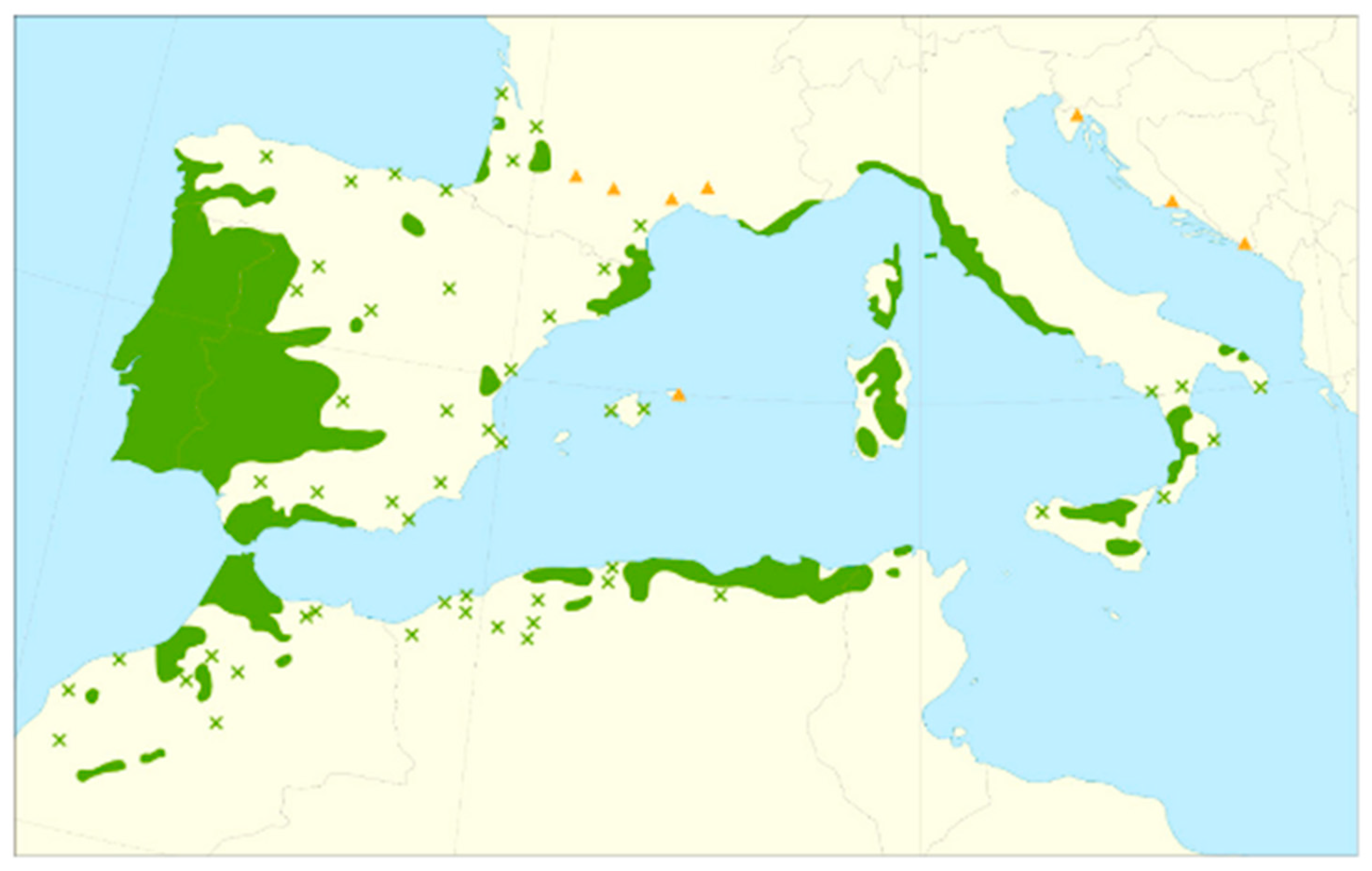
Cork oak (Quercus suber L.) woodlands have a key ecological and economic value in the Mediterranean region and cover approximately 2.2 million hectares, mainly distributed across seven countries: Portugal, Spain, Morocco, Algeria, Tunisia, Italy, and France [1] (Figure 1). Cork oak ecosystems refers broadly to two main structural types, primarily based on stand density but also taking into account their ecological functions, productive uses, and silvicultural management: (1) open cork oak systems characterized by low tree density and integrated grazing or cropping and (2) dense cork oak woodlands, with higher canopy cover, reduced understory management, and more continuous forest structure [2]. Open cork oak stands are mainly known as agroforestry and silvopastoral systems, structurally similar to savannas, and locally identified by various regional names—montado in Portugal, dehesa in Spain, azaghar in North Africa, and meriagos in Sardinia.
The ecological significance of cork oak systems extends beyond species richness to include their role in supporting globally and regionally threatened taxa [3]. These landscapes are recognized as biodiversity hotspots, sustaining high alpha-diversity across multiple taxa, including birds, mammals, amphibians, and reptiles, many of which are endemic or threatened. They also serve as critical habitats for migratory and overwintering bird species [4]. Variation in plant species composition among cork oak communities is shaped by geographic location, structural complexity, management regimes, and local ecological conditions [2]. As such, their sustainable management is of strategic importance for preserving biodiversity across the Mediterranean basin. Additionally, cork oak systems are iconic Mediterranean landscapes, protected by the Natura 2000 network and classified as “biodiversity-based product systems” under the Convention on Biological Diversity [5]. They are also listed in Annex I of the Habitats Directive [6] as key conservation habitats.
Characterized by low-input, multifunctional land management, cork oak ecosystems follow a “one system, multiple land uses” approach, delivering a wide range of regulating, supporting, and provisioning services. These include biodiversity conservation, carbon storage, soil protection, water retention, and landscape connectivity, as well as sustainable productions of goods such as cork, acorns, and forage. Socio-culturally, they support traditional pastoral and agricultural practices, shaping rural Mediterranean identities for millennia [2,7].
Figure 1. Map of the Quercus suber distribution area. Continuous green = native continuous range; green cross = isolated native populations; orange triangle = introduced and naturalized (synanthropic) populations (EUFORGEN Database [8]).
Diversity 17 00420 g001
Cork, the main product of cork oak trees, is one of the most valuable non-wood forest products worldwide [9]. Cork is traditionally stripped from the trunks of mature trees, typically older than 25 years, every 9 to 14 years, in a process that does not harm the tree and allows for continuous production over its lifespan. Its remarkable physical properties, such as low permeability, high elasticity, rot resistance, and thermal insulation, make it uniquely versatile. Historically, cork has played a crucial role in ancient civilizations for over 6000 years, used in fishing and maritime activities by the Greeks, Egyptians, Persians, and Chinese. In ancient Greece, cork’s softness and durability made it a material of choice for footwear—a tradition that persists to the present day. Nowadays, Portugal is the world leader in cork production (46%), followed by Spain (33%), Morocco (6%), Algeria (5%), Tunisia (4%), Italy (3%), and France (3%) [10]. While cork has a variety of applications, 70% of its production has historically been used for wine bottle stoppers [9]. This use dates back to Roman times and later expanded into industrial-scale production in the 17th century [2]. Although the demand for cork wine stoppers has declined due to concerns over “cork taint,” cork remains an environmentally sustainable material with a lower carbon footprint than plastic and aluminum alternatives [11,12]. Modern applications are valorizing other cork uses, which generate solid industrial activity, including insulation, aerospace materials, construction materials, and sustainable fashion [1].
Despite their economic, ecological, and cultural significance, cork oak woodlands have diminished over the past decades, increasingly threatened by both climatic and anthropogenic pressures [13,14]. Rural area abandonment, the expansion of mechanized agriculture, overgrazing, fires, rising temperatures, prolonged droughts, afforestation with exotic trees, pests, dieback, and the broader impact of climate change have all contributed to their decline [2]. This decline has been observed in several ecosystem features such as tree dieback, reduced growth and regeneration, tree canopy cover, lower cork yields and quality, and complex pest dynamics [15,16]. Climate change alone is projected to reduce cork production by up to 20% by the end of the 21st century [7]. These pressures not only undermine cork production but also compromise the long-term resilience of these fragile ecosystems.
Effectively addressing these challenges requires timely, accurate, and continuous monitoring. Remote sensing (RS) has emerged as a powerful tool for forest health monitoring, enabling the observation of large areas, faster data acquisition, and reduced costs compared to traditional field assessments [17]. RS includes various platforms, such as airborne LiDAR (Light Detection and Ranging) and UAVs (Unmanned Aerial Vehicles), which provide high-resolution data suitable for detailed local studies. However, airborne surveys are extremely resource-demanding in terms of both costs and time and less feasible for large-scale assessments. Given these considerations, this review focuses on spaceborne RS data, as only satellite-based observations provide consistent, comparable, and frequently updated information across broad areas at no cost—an essential requirement for monitoring cork oak systems, which are widespread across several Mediterranean countries and currently facing a general decline. Satellite RS enables systematic, repeatable, and scalable observations, supporting long-term assessments of tree cover, productivity, and ecosystem health [18]. It enables the creation of detailed, spatially explicit maps crucial for disturbance assessment [19], while offering a cost-effective solution for large-scale forest monitoring [20,21]. Freely available datasets such as Landsat (30 m spatial resolution, 16-day revisit time) and Sentinel-2 (up to 10 m spatial resolution, 5-day revisit time) provide medium to fine resolution and are widely used for monitoring forest ecosystems [22,23,24]. Furthermore, advancements in computational capabilities, machine learning, and artificial intelligence [25,26] have significantly enhanced RS data processing, enabling automated land cover classification, dieback risk prediction, and optimized conservation strategies [27,28,29].
In this context, a thorough assessment is needed to review the current state of the art of satellite RS application in monitoring cork oak woodlands. This work aims to provide a comprehensive overview of how RS has been applied to study these ecosystems and their associated ecosystem services. Specifically, this study investigates (i) where and which aspects of cork oak ecosystems have been monitored, (ii) the satellite data and derived predictors most commonly used as proxies, and (iii) the effectiveness of RS in assessing key parameters within these woodlands. Understanding these factors is essential for developing cost-effective and scalable methods to support the sustainable management and conservation of cork oak landscapes.

2. Materials and Methods

The selection of articles was conducted using the advanced search feature of Elsevier’s Scopus engine (www.scopus.com), URL accessed on 6 February 2025. The search included the following fixed keywords within the “Article title, Abstract and Keywords” fields: 1. (“cork oak” OR “quercus suber” OR “montado” OR “dehesa” OR “savannah like ecosystem*” OR “agrosilvopastoral mediterranean system*”) AND 2. (“remote sensing” OR “satellite” OR “earth observation” OR “MODIS” OR “sentinel” OR “landsat”). The search terms were intentionally designed to focus on spaceborne remote sensing applied to cork oak woodlands, ensuring a focused scope for the review. Consequently, terms related to airborne remote sensing technologies (e.g., “LiDAR”, “UAV”, “drone”) were not included, except in cases where such technologies were explicitly combined with satellite data. Based on this search, 145 papers were found. Then, only original, peer-reviewed, and final-stage publication papers defined as “Article” written in English were considered. Additionally, the selection was restricted to manuscripts published from 2010 onward, as advancements in technology have significantly shaped the field, making older research less relevant. This resulted in a final set of 104 articles. Since the terms dehesa and montado are sometimes used to describe not only cork oak (Quercus suber) woodlands but also other oak species, such as holm oak (Quercus ilex), relying solely on abstracts was not sufficient to determine a study’s relevance for our review. Therefore, a meticulous full-text review of all 104 articles was conducted to confirm the relevance of Quercus suber in the study and to ensure its inclusion in this review (Figure 2). More specifically, only articles addressing both the following two topics were selected: (A) the use of satellite-based remote sensing methodology, either alone or in combination with other techniques and (B) a focus on the cork oak (Quercus suber) or at least the inclusion of cork oak among the studied species. After applying these criteria and carefully reading the 104 articles, 35 articles were finally selected. In total, 16 articles were excluded because they did not address both topics (A) and (B). Overall, 25 articles were excluded because they did not address topic (A), and 28 articles were excluded because they did not address topic (B).
For the systematic review, a comprehensive analysis of the selected articles was conducted, and the following key information was extracted: (1) the country where the study was carried out, (2) the type of satellites data used, their spatial resolution, and the observation period, (3) the satellite-derived predictors and the object of the study, and (4) the main analysis methods or algorithms applied along with their accuracy metrics, namely the coefficient of determination (R2), root mean square error (RMSE), and the overall accuracy (OA). In detail, R2 represents the proportion of variance in the dependent variable explained by the model, ranging from 0 to 1, where values closer to 1 indicate better predictive performance. On the other hand, RMSE measures the difference between observed and predicted values, with lower RMSE indicating a more accurate model. Finally, OA quantifies the accuracy of classification models as the proportion of correctly classified instances out of the total predictions made. Accuracy metrics other than R2, RMSE, and OA were not reported in this review to maintain consistency and comparability across studies.
In addition, each article was categorized into one of four main research themes based on its primary objective and the specific application of satellite-based remote sensing. These thematic groups reflect the major areas of investigation within the selected literature and include the following: forest disturbances (FDs), which includes studies addressing drivers of cork oak forest degradation such as dieback, wildfires, and water stress; forest variables (FV), focusing on structural and functional aspects of the woodlands, including biomass, canopy cover, and productivity; classification (C), which involves land use and land cover mapping, as well as species identification using satellite data; and environmental variables (EV), covering broader climatic and ecological factors influencing cork oak ecosystems. Collectively, these thematic areas also provide key insights into the biodiversity dynamics of cork oak systems, highlighting how disturbances, forest structure, species distribution, and environmental conditions interact to shape ecosystem integrity and resilience. This classification was used to guide the organization of the results and to highlight prevailing research trends and existing knowledge gaps (table in below).

3. Results

3.1. Study Areas Distribution

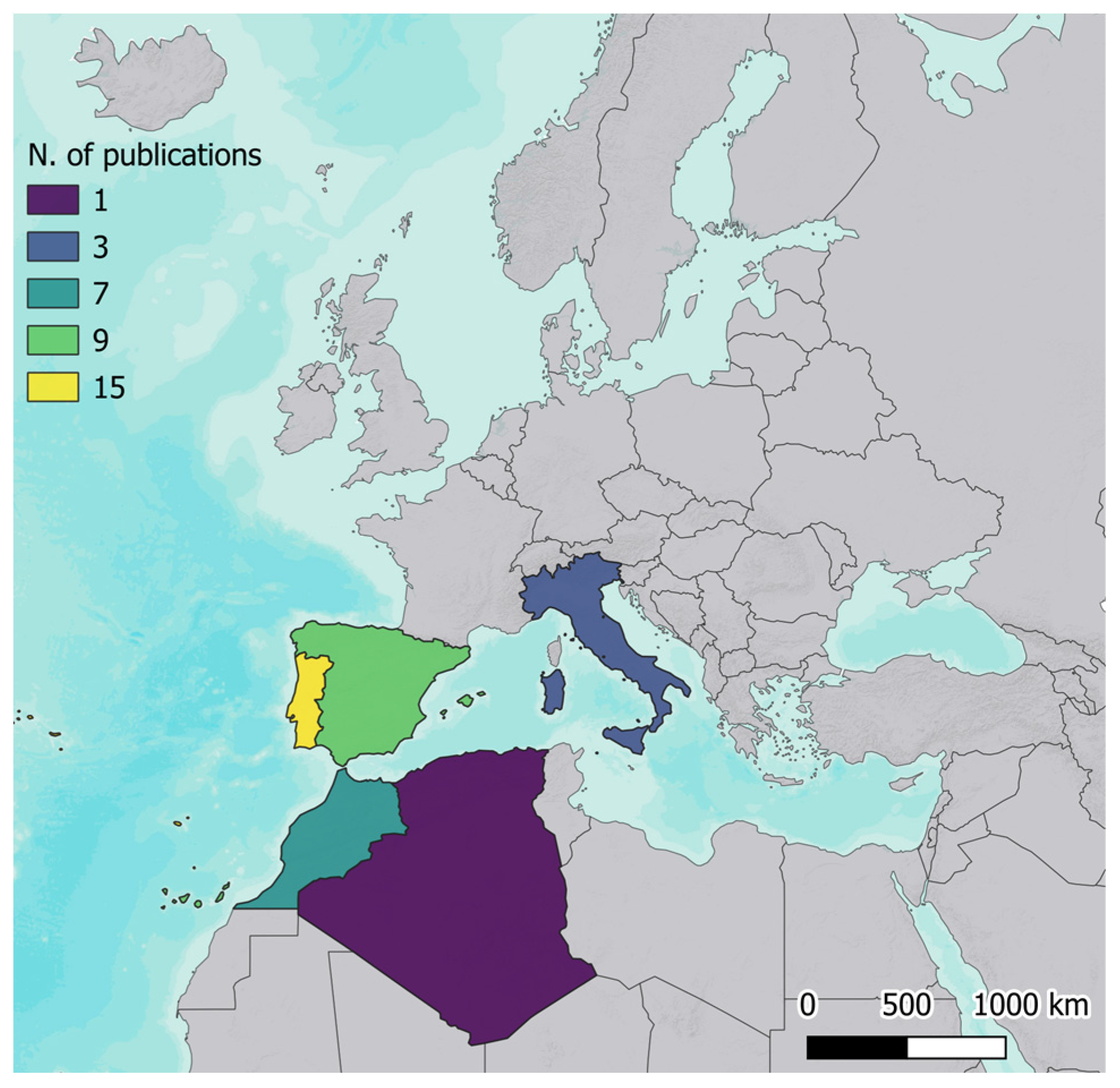
Portugal recorded the highest number of publications using satellite data for cork oak monitoring, with 15 articles, followed by Spain (9) and Morocco (7). Italy and Algeria showed significantly lower research output, with three and one publications each (Figure 3). No studies using satellite remote sensing specifically focused on cork oak were identified for France or Tunisia, despite these countries being part of the natural ecological distribution range of Quercus suber (Figure 1). The first studies from Morocco appeared only recently, starting in 2022 and in 2021 for Algeria.

3.2. Bibliometric Analysis

Building on the thematic classification presented in the methodology, the 35 articles selected for this review (Table 1) were analyzed according to their primary research focus, highlighting how satellite remote sensing has been applied to monitor cork oak woodlands across different domains. As shown in Figure 4, forest disturbances (FDs) represent the largest category and include 12 studies investigating various drivers of cork oak forest degradation, such as dieback and decline [30,31,32,33], epidemic outbreaks [34], wildfire risk assessment and post-wildfire vegetation recovery [35,36,37,38], deforestation hotspots [39], and water stress [40,41]. The second group, C, consisting of nine studies, primarily investigates land use and land cover changes over time, assessing how cork oak woodlands evolve in response to environmental and anthropogenic factors [42,43,44,45,46]. It also explores the spectral reflectance properties of cork oak trees [47,48], and species distribution [49]. FV includes eight studies and focuses on the structural and functional characteristics of cork oak woodlands. Research in this category focuses on biomass, carbon stock, and productivity [16,50,51,52,53,54], as well as tree canopy cover [55], tree canopy density [56], and evapotranspiration [57], providing insights on forest growth, carbon sequestration, and water balance. Lastly, the EV group comprises six studies that investigate broader climatic and ecological factors influencing cork oak ecosystems. This includes research on aridity [58], on the potential of vegetation indexes (VIs) in modelling soil organic matter (SOM) [59], on the suitability of ground-dependent vegetation (GDV) [60], hydrology [61], and water consumption [62], and on the role of oaks canopy cover in land surface temperature (LST) and albedo (LSA) [63].
Table 1. Results of the selected articles.
Ref.AOISatellite DataResolution [m]Observation
Period
Satellite-Derived PredictorsObject of the StudyTopicMain Method/
Algorithm
Accuracies
[59]ESLS30 1994–2021NDVIAridity-induced
phenological changes
EV R2 = 0.57
[32]ESMODIS250 2000–2022 Tree dover declineFDRTA (TS, CMK, FDR)OA = 70.4%
[35]ITS2, PS, S13 ÷ 10 2018–2022NDVI, GNDVI, MCARI, NDI45, NDWI, REIP, SCI, VH/VV, VHxVV, mRFDIEpidemic outbreaksFDRFOA = 74.4%
OA = 50.88%
[43]PTS210 2019GNDVI, SAVI, NDII, EVI, NDRE 1, NDRE 2, CILand cover changeCRF
KNN
OA = 92.16%
OA = 88.69%
[51]MALS30 1985–2020NDVI, ARVI, CIgreen, DVI, EVI, GNDVI, OSAVI, SAVI, TVIBiomass, Carbon stockFVMLR-biomass
MLR-carbon stock
R2 = 0.81
R2 = 0.69
[44]MALS30 1989–2022RGB 3, 2, 1
RGB 4, 3, 2
Land cover changeCMLCOA = 91.29%
[31]MALS15 ÷ 602015–2017NDVI, SAVIForest diebackFDMLR, Kruskal-Wallis ANOVA, MCA
[40]MALS30 2000–2020GFCDeforestation hotspotsFDGetis-Ord Gi MK
[36]MAMODIS2502002–2020Fire_CC51,
FIRMS
Wildfire risk assessmentFDOHA
EHA
[52]ESLS30 1994–2008NDVIBiomass, ProductivityFVGLMM-biomass
GLMM-productiv.
RMSE = 31.42 Mgha
RMSE = 0.73 Mg/ha
[37]ESLS, S2,
ASTER
10 ÷ 1002017–2021NDVI, LSTWildfire risk assessmentFD
[60]MALS 2018NDVIVIs for SOM modellingEVPearson correlation matrix, ANOVA, Newman-Keuls post-hoc test
[33]PTPleiades0.5 2018–2020 NDVI, RGI, GNDVIDead tree detectionFDK-means OA = 98%
[50]IT LS30 2000–2020NDVI, EVI, SAVI, EVI2, MSAVI, NBR, NDWISpecies distributionCRF, GBT, GLM, KNN, CART
[47]MAMODIS250 2000–2021NDVI, EVILand cover changeCPettitt homogeneity, MK
[62]ESS210 NDVIHydrology, terrain and vegetationEV
[45]DZLS30 1987–2017 Land cover changeCKNN
[63]PTLS,
MODIS
30 ÷
1000
2013–2015 Evapotranspiration (ET)EVSTARFM RMSE = 0.67 mm/day
[41]PTMODIS1000 ÷ 10,000 2001–2018NDVI, LSA, LSTWater stressFDSEBSR2 = 0.76
[38]ESLS601975–1993NDVIPostfire vegetation recoveryFD
[42]ESS2 NDVI, SAVIWater stressFDVI-ETo RMSE = 0.47 mm/day
[55]PTLS15 ÷ 30 1984, 1999, 2014EVI, SWIR32, CRI1, CIG, NMDI, SATVILand cover changeCSGBOA = 81.85%
OA = 75.58%
OA = 80.07%
[34]PTS210 ÷ 60 m2017–2018NDVI, SAVI, NDWI, GNDVI, CIred, VCIDiseased tree detectionFDCDFOA = 68%
[61]PTASTER25 NDWIGroundwater Dependent Vegetation (GDV)EVGWR
[16]PTLS, MODIS30 ÷ 250 1984–2017NDVIBiomass, Carbon stock, ProductivityFVMK, CMK, TS
[53]PTQB,
WV2
0.5 ÷ 0.7 2006, 2011EVI, SAVI, NDVI,
SR
Biomass, Carbon stock, ProductivityFVCSS, OOC
[46]PTLS30 1984–2009NDVI, TCTLand cover changeCCVA, SLCCOA = 71%
[56]PTS210 2015NDVI, PSRI
NDII, SWIR32, NDRE1-2-3
Tree canopy coverFVSGB
[58]ESLS,
MODIS
2012–2013LAI, LSTWater stress and ETFVTSEB
[54]PTLS 2000–2013EVIBiomass, Carbon stock, ProductivityFVTSA, Kendall’s Tau, Spearman’s correlation
[57]PTLS30 ÷ 120 AVI, BI, SI,
SSI, TI, B1-
B6
Canopy densityFVFCDOA = 78%
[64]PTLS,
MODIS
30 ÷ 120 2011EVI, SWIR32, CRI1,
CIgreen, NMDI,
SATVI
LST, LSAEVSGBR2 = 0.86
R2 = 0.94
[48]ITLS15 ÷ 302014–2015B1-B8Spectral signatureCMLC-Scr study area
MLC-Ang study area
OA = 93.3
OA = 87.7
[49]PTMODIS500 2011–2013NDVI, SAVI, EVISpectral signatureCGORT
[39]ESQB2.4 2003–2004NDVI, B1, B2, B3, B4Postfire vegetation recoveryFDRtA, BRTR2 = 0.50
R2 = 0.65
R2 = 0.79
Abbreviations—Satellite-derived predictors: ARVI (Atmospherically Resistant Vegetation Index), AVI (Advanced Vegetation Index), BI (Bare Soil Index), CI (Chlorophyll Index), CIgreen (Chlorophyll Index Green), CIred (Red-edge Chlorophyll Index),), CRI1 (Carotenoid Reflectance Index 1), ET (Evapotranspiration), GFC (Global Forest Cover Change), GNDVI (Green Normalized Difference Vegetation Index), LSA (Land Surface Albedo), LST (Land Surface Temperature), MCARI (Modified Chlorophyll Absorption in Reflectance Index), mRFDI (Modified Radar Forest Degradation Index), MSAVI (Modified Soil Adjusted Vegetation Index), NBR (Normalized Burn Ratio), NDII (Normalized Difference Infrared Index), NDRE (Normalized Difference Red Edge Index), NDVI (Normalized Difference Vegetation Index), NDWI (Normalized Difference Water Index), NMDI (Normalized Multi-band Drought Index), OSAVI (Optimized Soil Adjusted Vegetation Index), PSRI (Plant Senescence Reflectance Index), REIP (Red-Edge Inflection Point), RGI (Simple Ratio Red/Green Index), SATVI (Soil-Adjusted Total Vegetation Index), SCI (Soil Colour Index), SI (Shadow Index), SR (Simple Ratio), SSI (Scaled Shadow Index), SWIR32 (Short Wave Infrared Reflectance 3/2 Ratio), TCT (Tasseled Cap Transformation), TI (Thermal Index), TVI (Triangular Vegetation Index), VCI (Vegetation Condition Index), VH/VV, VH*VV. Abbreviations—Main method/algorithm: BRT (Boosted Regression Tree), CART (Classification and Regression Trees), CDF (Cumulative Distribution Function), CMK (Contextual Mann–Kendall Test), CVA (Change Vector Analysis), CSS (Contrast Split Segmentation), EHA (Emerging Hotspot Analysis), FCD (Forest Canopy Density), FDR (False Discovery Rate), GBT (Gradient Boosted Tree), GLM (Generalized Linear Model), GLMM (Generalized Linear Mixed Models), GORT (Geometric-Optical and Radiative Transfer), GWR (Geographically Weighted Regression), KNN (K-Nearest Neighbor), MCA (Multiple Correspondence Analysis), MLC (Maximum Likelihood Classification), MLR (Multiple Linear Regression),), MK (Mann-Kendall Test), OHA (Optimized Hotspot Analysis), OOC (Object-Oriented Classification), RF (Random Forest), RTA (Robust Trend Analysis), RtA (Regression Tree Analysis), SEBS (Surface Energy Balance System), SGB (Stochastic Gradient Boosting), SLCC (Supervised Land Cover Classification), STARFM (Spatial and Temporal Adaptive Reflectance Fusion Model), TSA (Time-Series Analysis), TS (Theil–Sen Slope), TSEB (Two-Source Energy Balance). Abbreviations—Topic: C (Classification), EVs (Environmental Variables), FDs (Forest Disturbances), FVs (Forest Variables). Abbreviations—Satellite Data: LS (Landsat), S2 (Sentinel-2), S1 (Sentinel-1), PS (PlanetScope), WV2 (WorldView2), QB (QuickBird).

3.3. Satellite Missions and Derived Predictors

As shown in Figure 5, the Landsat mission emerged as the most frequently used source of information (20 studies) among the analyzed studies, primarily applied for long-term monitoring of cork oak forests’ land cover change [43,44,45,54]. On the other hand, MODIS data, used in nine studies, supported large-scale analyses of vegetation dynamics [31], wildfire risk [35], and water stress [40] due to its daily revisit time. Several studies combined Landsat and MODIS information, such as to model evapotranspiration [62], forest health and productivity [16], surface energy fluxes and water use [57], and the role of oak canopy cover in land surface albedo (LSA) and temperature (LST) [63]. Furthermore, Sentinel-2 (seven studies) was mainly employed to detect cork oak decline [33] and map tree cover [55], thanks to its higher spatial resolution. Also, Sentinel-2 was integrated in one study together with PlanetScope and Sentinel-1, serving as an input in the Random Forest (RF) to model healthy and disease classes in the two cork oak distribution sites in Italy [34]. Finally, ASTER (two studies) was adopted to calculate the slope from the digital elevation model predicting the distribution of groundwater-dependent vegetation (GDV) in Portugal [61], while commercial satellites (QuickBird, WorldView2, Pléiades) appeared in isolated cases, mainly for high-resolution biomass estimation [52], to assess species richness recovery post-wildfire [38], and dead tree detection [32].
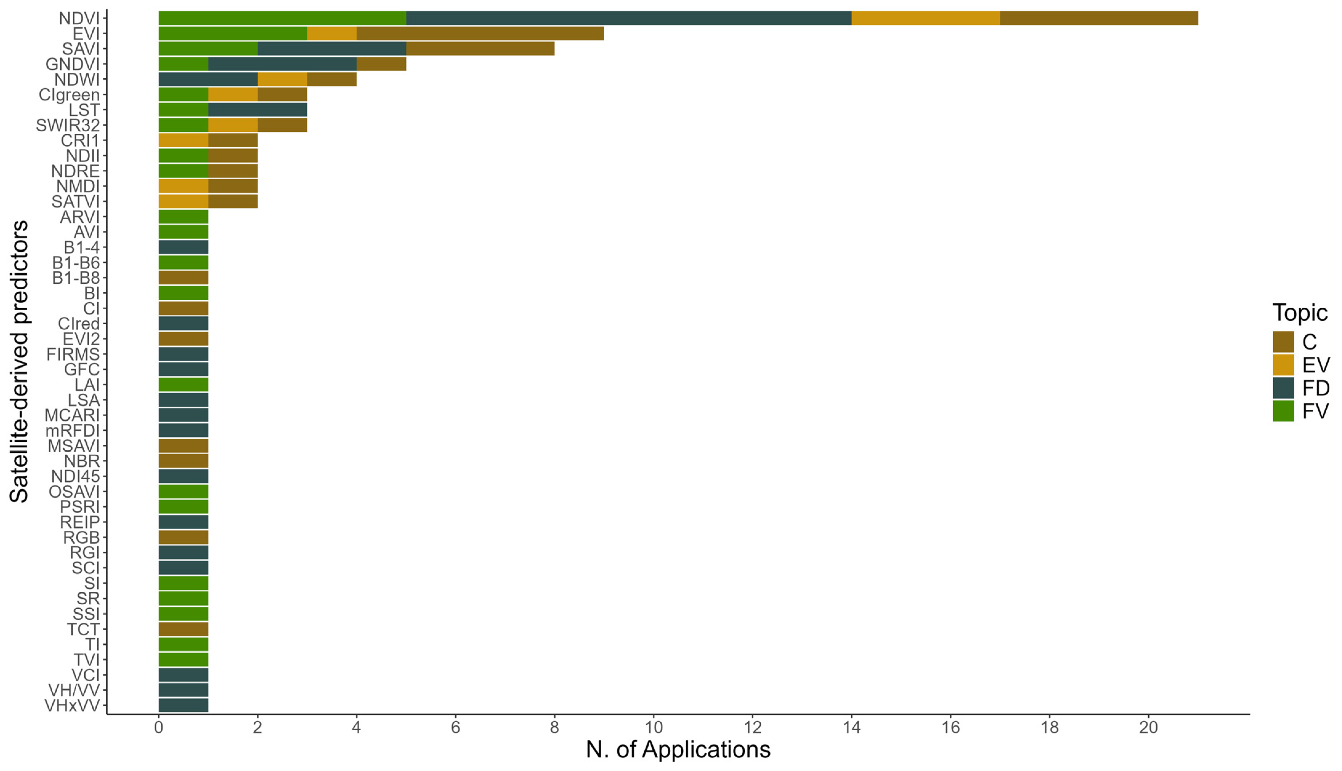
Among the satellite-based indices, the NDVI (Normalized Difference Vegetation Index) was the most frequently used, accounting for 60% of the studies analyzed (Figure 6). Indeed, NDVI has been used in all the research topics (FD, FV, C, EV). Similarly, EVI (Enhanced Vegetation Index) and SAVI (Soil-Adjusted Vegetation Index) were frequently employed (in 25% and 23% of the studies, respectively).

3.4. Statistical Performance

Among the studies reviewed in Table 1, model accuracy was primarily evaluated using supervised learning performance metrics, such as R2, RMSE, and OA.
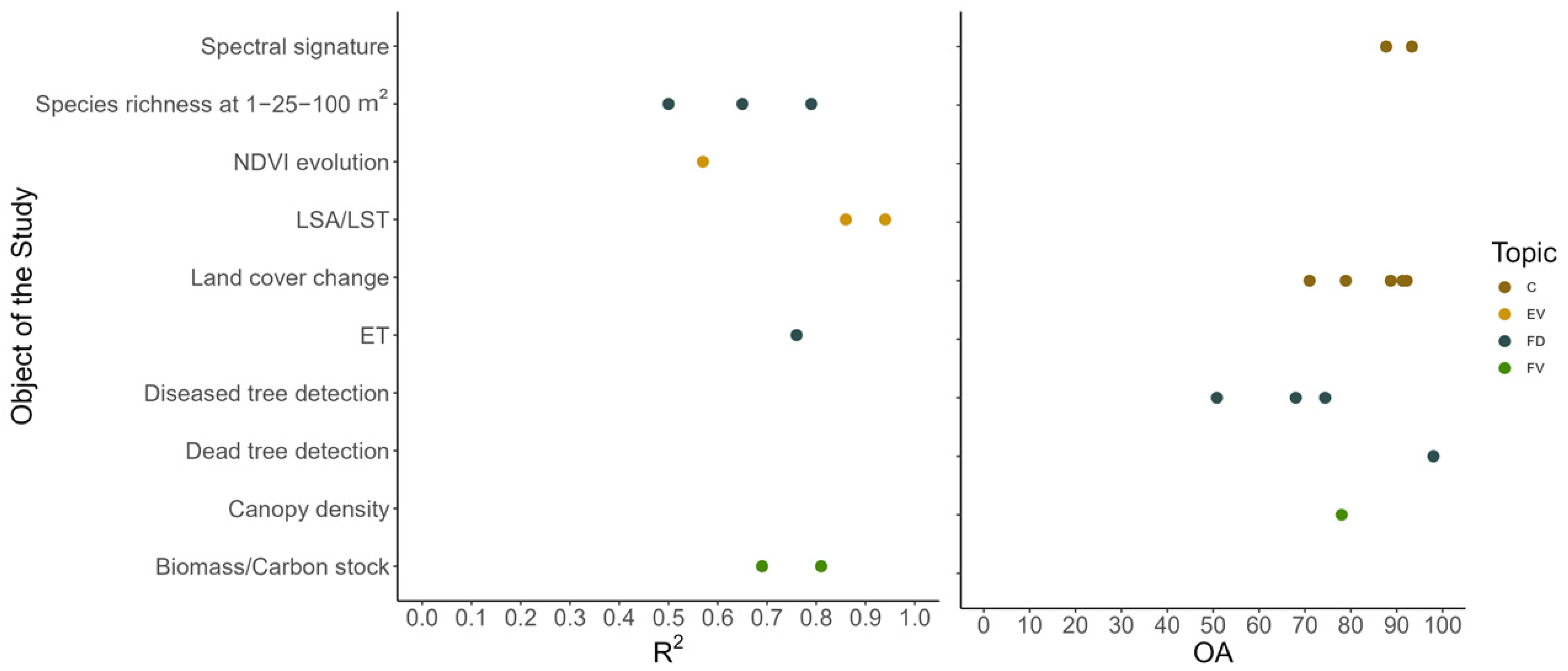
For R2 (Figure 7), the highest accuracy was reached by [63] in analyzing the impact of oak canopy cover on LSA and LST, achieving R2 values of 0.86 and 0.94, respectively. This study utilized Landsat and MODIS imagery and the Stochastic Gradient Boosting (SGB) hybrid machine learning. On the other hand, Ref. [50] assessed biomass and carbon stock spatialization and changes in Morocco’s Maamora cork oak forest, using multiple linear regression (MLR) and integrating Landsat imagery with UAV LiDAR and forest surveys. The highest accuracy was achieved for biomass (R2 = 0.81) and carbon stock (R2 = 0.69), with ARVI (Atmospherically Resistant Vegetation Index) performing as the most effective vegetation index. Ref [40] investigated long-term water stress in a cork oak ecosystem in Portugal using MODIS imagery and ERA-Interim tower data within the SEBS model, reaching an R2 of 0.76 to assess evapotranspiration (ET). Ref. [38] investigated species richness recovery in a cork oak woodland in Spain, one year after a wildfire, using very high-resolution QuickBird imagery. Among the spectral variables, reflectance and spectral contrast proved to be the most informative. The use of Boosted Regression Trees (BRT) and Regression Tree Analysis (RtA) enhanced predictive accuracy, particularly at broader spatial scales: R2 increased from 0.50 at a 1 m2 resolution to 0.79 at 100 m2. Finally, Ref. [58] analyzed 25 years of NDVI data from Landsat to evaluate phenological shifts due to aridity in Mediterranean forests, with an R2 of 0.57 for cork oak.
To assess classification performance, the OA was reported (Figure 7). The highest OA (98%) was achieved by [32] using a K-means unsupervised algorithm for NDVI on Pléiades very high resolution imagery for mapping cork oak mortality in a pasture environment. Here, NDVI proved effective in distinguishing healthy from dead cork oak trees. Similarly, Ref. [47] obtained 93.3% OA in characterizing the spectral signature of cork oaks, applying the Maximum Likelihood Classification (MLC) on Landsat imagery combined with digital photointerpretation and field surveys. Supervised machine learning approaches also demonstrated strong classification performance. For instance, Ref. [41] compared K-Nearest Neighbor (KNN) and Random Forest (RF) for forest cover mapping using Sentinel-2 in southern Portugal, with RF achieving the highest OA (92.16%) compared to KNN (88.69%). Similarly, Ref. [43] employed MLC on Landsat imagery to analyze land use and land cover changes in the Maamora Cork Oak Forest (Morocco), obtaining an OA of 91.29%.
Conversely, studies on disease detection reported lower accuracies. For instance, Ref. [34] monitored ink disease (Phytophthora cinnamomi) in cork oaks in southern Italy using Sentinel-1, Sentinel-2, and PlanetScope imagery, applying RF to assess different levels of disease severity. Here, OA reached 74.4% for two classes (healthy/damaged) but dropped to 50.8% when distinguishing among disease classes of different severity (healthy/damaged/severely damaged). Canopy density was also investigated: ref. [56] evaluated montado canopy density to identify High Nature Value (HNV) farmland using Landsat imagery and the Forest canopy density (FCD) model, achieving an OA of 78%.
Finally, for RMSE, the best performing models were developed by [41,62] for monitoring oak savanna vegetation water consumption and water stress. By estimating ET using Landsat and MODIS data as well as Sentinel-2, they achieved RMSE values of 0.47 mm/day and 0.67 mm/day, respectively. Ref. [51] modelled aboveground biomass and productivity, and the impact of climate change on various Mediterranean species, including cork oak, using Landsat imagery. Here, spectral (NDVI) and structural (tree density) variables have proven to be the most relevant variables for modelling forest biomass (RMSE = 31.42 Mg/ha) and productivity (RMSE = 0.73 Mg/ha) for cork oak trees.

4. Discussion

4.1. Contextualization of the Study

Satellite-based remote sensing (RS) provides ready-to-use, free, and high spatial and temporal resolution data that has increasingly been adopted in forest monitoring worldwide. In the last few years, satellite RS is becoming an important component to monitor cork oak (Quercus suber) ecosystems, as these landscapes face growing environmental and socio-economic pressures. This study comprehensively reviews 35 peer-reviewed articles retrieved through a structured search on the Scopus database, using specific keywords related to cork oak systems and RS technologies. Our review is a valuable snapshot of current research trends, methodological approaches, and knowledge gaps, offering insights for future scientific development and practical applications, and should represent a key document for guiding researchers approaching this topic.

4.2. Spatial Overview of Reviewed Research

Most of the reviewed studies were conducted in Portugal and Spain, accounting for 12 and 9 studies, respectively. This geographic concentration reflects the significant ecological and economic weight of cork oak systems in these two countries, which together represent approximately 80% of global cork production. In addition to being the primary non-wood forest product in Southern Europe [64], cork harvesting remains deeply embedded in the socio-cultural fabric of Iberian rural areas and constitutes a key pillar of the local bioeconomy [9]. Morocco has shown a recent rise in publications of satellite-based monitoring of cork oak ecosystems, especially after 2022, reflecting increased attention to sustainable forest management, certification initiatives, and the conservation of Mediterranean silvopastoral systems. Morocco’s efforts aim to support both biodiversity and the livelihoods of smallholders and local communities [14]. In contrast, research output remains limited in Italy (3) and North African countries like Algeria (1), while France and Tunisia showed no satellite-based studies specifically focused on cork oak, despite being part of the natural distribution of Quercus suber (Figure 1). This spatial imbalance may stem from a decreasing economic interest in cork oak woodlands, as their lower economic returns, compared to western Mediterranean countries with shorter harvest cycles and higher yields [14], reduce their appeal and the incentive for active management. Additionally, the relatively low number of studies originating from North African countries can be largely explained by structural constraints, including limited access to scientific infrastructure, insufficient research funding, and a lack of sustained international collaboration. These dynamics highlight the urgent need for integrated, transboundary strategies to effectively monitor, conserve, and manage cork oak ecosystems under increasing socio-ecological pressures across the Mediterranean basin [65].

4.3. Research Focus and Thematic Gaps

The reviewed studies were aggregated into four main research topics: forest disturbance (FD), forest variables (FVs), land cover classification (C), and environmental variables (EVs), with FD and C emerging as the most explored topics. Studies on FD, such as cork oak woodlands dieback and decline [30,31,32,33], pest outbreaks [34], wildfire risk [35,36,37,38], and water stress [40,41] reflect the vulnerability of cork oak ecosystems to climate change and biotic and anthropogenic pressures. Research on C examined land cover changes in cork oak ecosystems over time [42,43,44,45], reflecting a general cork oak decline all over the areas of study. Research on FV investigated indicators such as biomass, carbon stock, and evapotranspiration [16,51,52,53,54,55,58] to assess ecosystem health, carbon dynamics, and productivity, highlighting not only ecological functions but also the economic value of cork. These pressures are driving land abandonment, contributing to significant biodiversity loss, and undermining the crucial ecosystem services provided by these landscapes, underscoring the need for robust policy frameworks to support sustainable forest management and land-use planning [65,66].
However, some ecologically crucial themes remain underexplored. Topics such as biodiversity and ecosystem resilience are rarely addressed directly. When they do appear, they are often isolated cases with limited cross-comparability, hindering the development of a systemic understanding of cork oak ecosystem functioning. For example, the assessment of cork oak forest post-wildfire resilience [37] provides valuable insight into resilience but is restricted to specific contexts. Studies on groundwater dependency [60] and soil organic matter [59] explore environmental variables relevant to cork oak ecosystems, yet they are disconnected from broader ecological assessments. Similarly, research on landscape connectivity [54] focuses on aspects related to biodiversity but remains a standalone analysis. Collectively, these cases underline the fragmented nature of current research and highlight the need for more integrated approaches.
An important step forward for a more comprehensive understanding of resilience would be to leverage satellite-derived recovery metrics. Ref. [67] demonstrated how long-term Landsat time series can effectively quantify disturbance and recovery dynamics at a large scale using metrics such as Year to Recovery (Y2R). Adapting similar methodologies to cork oak ecosystems, which are increasingly exposed to multiple pressures and disturbances, could provide scalable and repeatable insights into resilience patterns, supporting informed management decisions. In terms of biodiversity, Ref. [68] showed that spectral diversity derived from high-resolution IKONOS satellite imagery can successfully predict habitat heterogeneity and plant species richness in temperate mixed forests. Applying such methods to cork oak woodlands could enhance biodiversity monitoring across large spatial scales, offering an opportunity to connect remote sensing indicators with ecological processes and overcoming the limitations of isolated field-based studies.

4.4. Satellite Data and Derived Predictors

Among satellite missions, Landsat emerged as the most frequently used, appearing in 20 studies. Its long temporal record and its freely available datasets make it suitable for long-term monitoring of forest variables such as biomass, carbon stock, and land cover changes. MODIS, used in 9 studies, enabled large-scale monitoring of vegetation and hydrological variables such as evapotranspiration and water stress. However, a few limitations were found in the MODIS application, such as coarse spatial resolution (250–1000 m). It often fails to capture fine-scale variability, limiting the effectiveness in detecting subtle changes in cork oak cover, especially in mixed forest systems or fragmented landscapes [31,35]. Sentinel-2, thanks to its higher spatial and temporal resolution, proved particularly effective for studies on FD, including damage detection, species differentiation, and water stress assessment. Commercial satellite data, such as QuickBird, WorldView2, and Pléiades, have been used only in isolated cases. This highlights the key role of open-access satellite missions, which provide broader accessibility.
NDVI was the most widely applied vegetation index across all research themes, with a total of 20 applications. This aligns with the fact that NDVI is the most popular vegetation index in remote sensing. Its dominance stems from its historical significance, simplicity, broad applicability, and effectiveness in extracting vegetation information from multispectral imagery [69]. NDVI showed a highly significant correlation with dieback severity [30], forest biomass and productivity [51], or soil organic matter (SOM) [59]. Furthermore, NDVI proved to be highly effective in distinguishing healthy from dead cork oak trees [32]. However, this accuracy was likely influenced by the well-spaced distribution of trees. In dense forests or areas where cork oak canopies overlap, the algorithm failed to identify individual trees [32]. Nevertheless, its limitations are well-documented, as it tends to saturate under high biomass conditions and performs poorly in dense or overlapping canopies [48]. As a result, complementary indices—such as EVI, SAVI, and texture-based or SWIR-derived metrics—were increasingly adopted to overcome these issues, especially in heterogeneous Mediterranean landscapes [48].
Several studies integrated or validated satellite data with other methodologies, achieving improved model performance. For instance, [16,51,60] used National Forest Inventories (NFIs) alongside satellite information, while [33,47] combined remote sensing with field surveys and UAV data. Other studies incorporated ALS data [36] or validated satellite data with UAV LiDAR and ground observations [50]. These approaches demonstrated the value of combining satellite data with higher-resolution, detailed measurements from airborne or ground-based platforms to improve accuracy and understanding of cork oak ecosystems.
Interestingly, while hyperspectral data from airborne platforms or portable spectrometers have been frequently used to study cork oak ecosystems [70,71,72,73], no studies were found that applied hyperspectral data from spaceborne sensors to these environments. Considering the recent availability of free and open-access hyperspectral satellite missions (e.g., PRISMA, EnMAP) and their ability to cover much larger study areas compared to the methods mentioned above, this gap presents a promising opportunity to expand cork oak monitoring with detailed spectral information at a broader spatial scale.

4.5. Methods and Statistical Performance

Machine learning techniques have been widely adopted (24 different methods used), reflecting the growing complexity and volume of satellite data. Random Forest (RF), K-Nearest Neighbors (KNN), Mann-Kendall (MK), and Stochastic Gradient Boosting (SGB) were each applied three times across the studies. However, their use was highly heterogeneous, not only in terms of the variety of algorithms but also in the diversity of topics addressed (e.g., forest disturbances, productivity, land cover classification) and the characteristics of the input data (e.g., sensor type, temporal extent, spatial resolution), which complicates direct comparisons of results and the integration of findings across studies. Moreover, many studies could not be included in a direct comparison of accuracy because they used unusual accuracy metrics that were not adopted by any other studies. This lack of standardization was particularly evident in studies focusing on carbon stock, biomass, and productivity [16,52,53], where different accuracy metrics were used, making it difficult to compare with studies on the same topic like [50], which used R2, or [51], which used RMSE. Similarly, research on environmental variables such as [37,59,61] lacked standard accuracy evaluation methods. On the other hand, land cover classification studies were generally more consistent, with most adopting OA as accuracy metric, enabling more direct cross-comparison.
Despite these challenges, some models achieved better performances than others: Ref. [63] reported the highest R2 values (0.86–0.94) when analyzing the influence of oak canopy cover on land surface albedo (LSA) and temperature (LST), demonstrating that a potential tree canopy cover regression in oak ecosystem may produce significant changes in LSA and LST, which from a long-term perspective that may potentially alter the micrometeorological conditions affecting cork oak ecosystem functioning and sustainability. Meanwhile, Ref. [41] reported the lowest RMSE (0.47 mm/day) by estimating ET using Sentinel-2 for monitoring water consumption and water stress in cork oak savanna. Finally, Ref. [32] reached 98% OA with a K-means unsupervised algorithm on Pléiades very high resolution imagery for cork oak mortality mapping in a pasture environment. On the other hand, other studies suffered from poor performance in complex classification tasks, particularly in discriminating different classes of tree disease severity (intermediate damaged/severely damaged) with an OA of 50.8% [34].

4.6. From Monitoring to Management: Enhancing Ecosystem Resilience Through Sustainable Practices

Cork oak forests represent key ecosystems that provide ecological, cultural, and economic services. However, these forests are increasingly threatened by climate change and human pressures, with challenges including rising tree mortality, prolonged droughts, pest infestations, more frequent wildfires, and forest abandonment. Warmer and drier springs and summers are expected to reduce cork harvests and likely hinder cork oak growth, particularly in continental, seasonally dry regions of the main cork-producing countries [7]. The reviewed studies report a consistent and serious decline of cork oak ecosystems across all examined countries of study. The analysis of Los Alcornocales Natural Park (Spain), Europe’s largest cork oak forest, reveals significant declines in tree cover between 2000 and 2022, highlighting the severity of oak decline [31]. In Morocco, a decrease in cork oak cover (from 60.71% to 44.42%) and an increase in eucalyptus (from 18.11% to 39.31%) have been identified [43]. Additionally, studies in Morocco [35,39] identify the main regions affected by deforestation and wildfires in cork oak and matorral stands. Research by [54] highlights the increasing isolation and fragmentation of montado properties in Portugal. Managing these declining forests is a critical challenge that must be addressed to maintain the ecosystem services provided by cork oak forests and ensure their resilience in the near future. Therefore, continuous and long-term monitoring is essential to assess the status of ecosystem assets and track environmental trends [74]. Addressing these challenges requires adaptive strategies that combine continuous monitoring, advanced technologies, and localized restoration efforts to support the long-term sustainability of these ecosystems [7,75].
A proactive, forward-looking approach is needed for managing these agroforestry ecosystems. Remote sensing (RS) constitutes an essential tool for informing and supporting ecosystem management, providing scalable, cost-efficient, and continuous monitoring of ecological conditions. By harnessing satellite-derived data, it is possible to detect areas of decline, evaluate stressors such as drought and canopy degradation, and prioritize targeted interventions, including thinning, pest management, and water regulation. These data-driven insights facilitate the implementation of a wide array of adaptive management strategies—from wildfire prevention and rotational grazing to the enhancement of landscape connectivity—that collectively bolster ecosystem resilience and promote the long-term sustainability of cork oak woodlands. Among these, certain nature-based approaches, such as restoring degraded areas or promoting multifunctional land use, can complement technical and silvicultural measures to enhance overall system functionality [15,76]. The adoption of integrated management approaches also requires strong political will and policy support for sustainable forest management and ecosystem restoration, ensuring the long-term sustainability of cork oak forests and addressing global ecological challenges [74,75]. Combining cutting-edge monitoring technologies with adaptive management and supportive policy frameworks is essential to address current challenges and maintain the ecological integrity and productivity of these ecosystems.

4.7. Future Research Directions

Despite growing interest and technological progress, the use of satellite RS for monitoring cork oak ecosystems remains in an early stage of development, with a total of just 35 articles published to date. As highlighted throughout this review, significant potential remains untapped, particularly in terms of methodological standardization, thematic expansion, and operational integration.
The reviewed studies addressed a variety of topics, from forest disturbances to productivity, land cover classification, and environmental variables, which naturally leads to differences in objectives in data characteristics. However, certain components of the methodological workflow could benefit from greater standardization. For example, the consistent use of validation metrics (e.g., OA, RMSE, R2) would improve comparability across studies on similar topics and enable clearer benchmarking of model performance. Rather than aiming for a universal framework that covers all possible research questions, a more feasible approach would be to establish standardized components within flexible workflows, allowing for both comparability and thematic specificity.
At the same time, there is a need to broaden the thematic scope of RS applications. To date, most studies have focused on forest structure and stress indicators, such as canopy cover, biomass, or water stress. However, to effectively support conservation and restoration efforts, monitoring must also capture more functional and ecological indicators, including biodiversity, ecosystem services, and resilience. These variables are essential to understand long-term ecosystem functioning but remain poorly represented in scientific literature, often addressed only through indirect proxies.
Future studies should also seek to improve data integration across spatial scales and data sources. The combination of satellite imagery with UAV data, field surveys, and airborne LiDAR can provide a more comprehensive and nuanced picture of cork oak ecosystem dynamics [42]. Recent advances in satellite missions, such as the Harmonized Landsat and Sentinel-2 (HLS) products, also offer promising opportunities for higher temporal and spatial resolution, which could significantly enhance predictive power and monitoring precision [49]. Further exploration of alternative spectral indices—such as NDWI, NMDI, PSRI, and SWIR-based composites—may support more accurate assessments of moisture stress, senescence, and vegetation health. Furthermore, the lack of hyperspectral satellite data in cork oak studies highlights an area for future exploration. With the availability of free hyperspectral missions like PRISMA and EnMAP, there is an opportunity to enhance monitoring efforts. For example, Ref. [77] demonstrated PRISMA’s potential for detailed forest fuel types mapping in Mediterranean holm oak forests, a methodology that could be adapted to cork oak ecosystems. In parallel, research efforts should be extended to regions currently under-monitored, particularly in North Africa, to ensure a more comprehensive understanding of cork oak ecosystems across their full biogeographic range. Strengthening scientific collaboration and capacity-building in these areas will be essential to achieve a more equitable and comprehensive understanding of cork oak woodlands across their full biogeographic range.
Finally, remote sensing research should move beyond technical accuracy and align more closely with practical management needs and policy frameworks. A stronger integration with adaptive forest management strategies, such as the EU Biodiversity Strategy, is essential to ensure that scientific innovations effectively support operational and policy-relevant actions. This involves designing RS tools not only for academic purposes, but also as practical instruments for restoration planning, early-warning systems, and performance monitoring of conservation efforts.

5. Conclusions

Cork oak woodlands represent one of the most emblematic agro-silvo-pastoral systems of the Mediterranean basin, renowned for their sustainable production of cork—one of the most valuable non-wood forest products worldwide—and for supporting a wide range of flora and fauna, including endemic and threatened species, while playing a vital role in sustaining ecosystem services and rural livelihoods. Yet they are increasingly vulnerable to climatic and anthropogenic stressors, land abandonment, and degradation. Satellite RS represents an increasingly essential tool for monitoring forest dynamics, enabling the tracking of ecological health, species habitat quality, and forest degradation on cork oak systems—topics directly relevant to biodiversity and conservation. Based on the current body of literature, three main conclusions can be drawn.
First, the use of satellite RS in cork oak landscapes is still a relatively young and evolving field. Although several innovative applications exist, the lack of common protocols and methodological benchmarks reveals both a gap and a promising potential for further development and interdisciplinary collaboration.
Second, the integration of multi-source satellite data with advanced modelling techniques, such as machine learning and time-series analysis, has demonstrated high potential for capturing key forest variables, including decline dynamics, productivity trends, and hydrological stress. These methods offer scalable solutions for both local assessments and international planning.
Third, to fully support more effective agroforestry management, future research should expand toward more functional and ecosystem-based indicators, incorporating variables such as biodiversity and ecosystem resilience. Strengthening the connection between RS outputs, practical management strategies and policies can provide critical support for adaptive decision-making and the implementation of sustainable practices.
Our review provides a valuable overview of current research trends, methodological approaches, and existing knowledge gaps. It offers insights to support future scientific advancements and practical applications, serving as a key reference for researchers entering this field.

Author Contributions

Conceptualization, S.F., E.B. and F.S.; methodology, S.F. and E.B.; formal analysis, E.B.; investigation, E.B. and S.A.; data curation, E.B., C.B. and S.F.; writing—original draft preparation, E.B. and S.F.; writing—review and editing, E.B., S.F., S.A., F.S., M.M. and G.C.; visualization, E.B.; supervision, S.F. All authors have read and agreed to the published version of the manuscript.

Funding

This research was carried out in the framework of the following projects: DRYAD, project funded by the European Commission, number 101156076. FORWARDS. H2020 project funded by the European Commission, number 101084481 call HORIZON-CL6-2022-CLIMATE-01-05. MONIFUN. H2020 project funded by the European Commission, number 101134991 call HORIZON-CL6-2023-CircBio-01-14. NextGenCarbon. H2020 project funded by the European Commission, number 101184989 call HORIZON-CL5-2024-D1-01-07. SUPERB. H2020 project funded by the European Commission, number 101036849 call LC-GD-7-1-2020; MULTIFOR “Multi-scale observations to predict Forest response to pollution and climate change” PRIN 2020 Research Project of National. Relevance funded by the Italian Ministry of University and Research (prot. 2020E52THS). This research received no external funding.

Conflicts of Interest

The authors declare no conflicts of interest.

References

  1. Houston Durrant, T.; de Rigo, D.; Caudullo, G. Quercus Suber in Europe: Distribution, Habitat, Usage and Threats. In European Atlas of Forest Tree Species; Publication Office of the European Union: Luxembourg, 2016; pp. 1–8. [Google Scholar]
  2. Aronson, J.; Pereira, J.S.; Pausas, J.G. Cork Oak Woodlands on the Edge: Ecology, Adaptive Management, and Restoration; Island Press: Washington, DC, USA, 2009; ISBN 978-1-59726-478-5. [Google Scholar]
  3. Selvi, F.; Valleri, M. Cork Oak Woodlands in the North Tyrrhenian Area (Italy): Distribution and Plant Species Diversity of a Relict Forest Ecosystem. Biodivers. Conserv. 2012, 21, 3061–3078. [Google Scholar] [CrossRef]
  4. Dias, F.S.; Bugalho, M.N.; Orestes Cerdeira, J.; João Martins, M. Is Forest Certification Targeting Areas of High Biodiversity in Cork Oak Savannas? Biodivers. Conserv. 2013, 22, 93–112. [Google Scholar] [CrossRef]
  5. Pollastrini, M.; Chiavetta, U.; Cutini, A.; Casula, A.; Maltoni, S.; Dettori, S.; Corona, P. Indicators for the Assessment and Certification of Cork Oak Management Sustainability in Italy. iForest—Biogeosci. For. 2018, 11, 668–674. [Google Scholar] [CrossRef]
  6. European Commission. Council Regulation (EEC) No 1973/92 of 21 May 1992 Establishing a Financial Instrument for the Environment (LIFE). Off. J. Eur. Communities 1992, 35, 2–6. [Google Scholar]
  7. Camarero, J.J.; Gazol, A.; Valeriano, C.; Colangelo, M.; Rubio-Cuadrado, Á. Growth Responses to Climate and Drought in Relict Cork Oak Populations as a Benchmark of the Species Tolerance. Forests 2023, 15, 72. [Google Scholar] [CrossRef]
  8. Caudullo, G.; Welk, E.; San-Miguel-Ayanz, J. Chorological Maps for the Main European Woody Species. Data Br. 2017, 12, 662–666. [Google Scholar] [CrossRef]
  9. Bugalho, M.N.; Caldeira, M.C.; Pereira, J.S.; Aronson, J.; Pausas, J.G. Mediterranean Cork Oak Savannas Require Human Use to Sustain Biodiversity and Ecosystem Services. Front. Ecol. Environ. 2011, 9, 278–286. [Google Scholar] [CrossRef]
  10. APCOR Cortiça. Cork 2020; Associação Portuguesa da Cortiça: Aveiro, Portugal, 2020; pp. 1–108. [Google Scholar]
  11. Yadav, M.; Singhal, I. Sustainable Construction: The Use of Cork Material in the Building Industry. Mater. Renew. Sustain. Energy 2024, 13, 375–383. [Google Scholar] [CrossRef]
  12. Gibson, L.J. Cork: Structure, Properties, Applications. Available online: https://arboretum.harvard.edu/stories/cork-structure-properties-applications/ (accessed on 18 April 2025).
  13. Marques, M.; Bugalho, M.N.; Acácio, V.; Catry, F.X. Disentangling Research on Oak Decline Factors in Mediterranean-Type Climate Regions: A Systematic Review. Trees For. People 2025, 19, 100803. [Google Scholar] [CrossRef]
  14. FAO; Plan Bleu. State of Mediterranean Forests 2018; Food and Agriculture Organization of the United Nations (FAO): Rome, Italy; Plan Bleu: Marseille, France, 1310; ISBN 978-92-5-131047-2. [Google Scholar]
  15. Palma, J.H.N.; Paulo, J.A.; Faias, S.P.; Garcia-Gonzalo, J.; Borges, J.G.; Tomé, M. Adaptive Management and Debarking Schedule Optimization of Quercus Suber L. Stands under Climate Change: Case Study in Chamusca, Portugal. Reg. Environ. Change 2015, 15, 1569–1580. [Google Scholar] [CrossRef]
  16. Aubard, V.; Paulo, J.A.; Silva, J.M.N. Long-Term Monitoring of Cork and Holm Oak Stands Productivity in Portugal with Landsat Imagery. Remote Sens. 2019, 11, 525. [Google Scholar] [CrossRef]
  17. Stone, C.; Mohammed, C. Application of Remote Sensing Technologies for Assessing Planted Forests Damaged by Insect Pests and Fungal Pathogens: A Review. Curr. For. Rep. 2017, 3, 75–92. [Google Scholar] [CrossRef]
  18. Borghi, C.; Francini, S.; Pollastrini, M.; Bussotti, F.; Travaglini, D.; Marchetti, M.; Munafò, M.; Scarascia-Mugnozza, G.; Tonti, D.; Ottaviano, M.; et al. Monitoring Thirty-Five Years of Italian Forest Disturbance Using Landsat Time Series. Planet Care Space 2021, 2, 112–115. [Google Scholar]
  19. Forzieri, G.; Pecchi, M.; Girardello, M.; Mauri, A.; Klaus, M.; Nikolov, C.; Rüetschi, M.; Gardiner, B.; Tomastik, J.; Small, D.; et al. A Spatially Explicit Database of Wind Disturbances in European Forests over the Period 2000–2018. Earth Syst. Sci. Data 2020, 12, 257–276. [Google Scholar] [CrossRef]
  20. Gómez, C.; White, J.C.; Wulder, M.A. Optical Remotely Sensed Time Series Data for Land Cover Classification: A Review. ISPRS J. Photogramm. Remote Sens. 2016, 116, 55–72. [Google Scholar] [CrossRef]
  21. Hansen, M.C.; Potapov, P.V.; Moore, R.; Hancher, M.; Turubanova, S.A.; Tyukavina, A.; Thau, D.; Stehman, S.V.; Goetz, S.J.; Loveland, T.R.; et al. High-Resolution Global Maps of 21st-Century Forest Cover Change. Science 2013, 342, 850–853. [Google Scholar] [CrossRef]
  22. Müller, M.; Olsson, P.-O.; Eklundh, L.; Jamali, S.; Ardö, J. Response and Resilience to Drought in Northern Forests Revealed by Sentinel-2. Int. J. Remote Sens. 2024, 45, 5130–5157. [Google Scholar] [CrossRef]
  23. Francini, S.; Chirici, G. A Sentinel-2 Derived Dataset of Forest Disturbances Occurred in Italy between 2017 and 2020. Data Br. 2022, 42, 108297. [Google Scholar] [CrossRef]
  24. Giannetti, F.; Pecchi, M.; Travaglini, D.; Francini, S.; D’Amico, G.; Vangi, E.; Cocozza, C.; Chirici, G. Estimating VAIA Windstorm Damaged Forest Area in Italy Using Time Series Sentinel-2 Imagery and Continuous Change Detection Algorithms. Forests 2021, 12, 680. [Google Scholar] [CrossRef]
  25. Francini, S.; Chirici, G.; Chiesi, L.; Costa, P.; Caldarelli, G.; Mancuso, S. Global Spatial Assessment of Potential for New Peri-Urban Forests to Combat Climate Change. Nat. Cities 2024, 1, 286–294. [Google Scholar] [CrossRef]
  26. Gorelick, N.; Hancher, M.; Dixon, M.; Ilyushchenko, S.; Thau, D.; Moore, R. Google Earth Engine: Planetary-Scale Geospatial Analysis for Everyone. Remote Sens. Environ. 2017, 202, 18–27. [Google Scholar] [CrossRef]
  27. Bozzini, A.; Francini, S.; Chirici, G.; Battisti, A.; Faccoli, M. Spruce Bark Beetle Outbreak Prediction through Automatic Classification of Sentinel-2 Imagery. Forests 2023, 14, 1116. [Google Scholar] [CrossRef]
  28. Cavalli, A.; Francini, S.; McRoberts, R.E.; Falanga, V.; Congedo, L.; De Fioravante, P.; Maesano, M.; Munafò, M.; Chirici, G.; Scarascia Mugnozza, G. Estimating Afforestation Area Using Landsat Time Series and Photointerpreted Datasets. Remote Sens. 2023, 15, 923. [Google Scholar] [CrossRef]
  29. D’Amico, G.; Francini, S.; Giannetti, F.; Vangi, E.; Travaglini, D.; Chianucci, F.; Mattioli, W.; Grotti, M.; Puletti, N.; Corona, P.; et al. A Deep Learning Approach for Automatic Mapping of Poplar Plantations Using Sentinel-2 Imagery. GISci. Remote Sens. 2021, 58, 1352–1368. [Google Scholar] [CrossRef]
  30. Dallahi, Y.; Boujraf, A.; Meliho, M.; Orlando, C.A. Assessment of Forest Dieback on the Moroccan Central Plateau Using Spectral Vegetation Indices. J. For. Res. 2023, 34, 793–808. [Google Scholar] [CrossRef]
  31. Gutiérrez-Hernández, O.; García, L.V. Robust Trend Analysis in Environmental Remote Sensing: A Case Study of Cork Oak Forest Decline. Remote Sens. 2024, 16, 3886. [Google Scholar] [CrossRef]
  32. Catalão, J.; Navarro, A.; Calvão, J. Mapping Cork Oak Mortality Using Multitemporal High-Resolution Satellite Imagery. Remote Sens. 2022, 14, 2750. [Google Scholar] [CrossRef]
  33. Navarro, A.; Catalao, J.; Calvao, J. Assessing the Use of Sentinel-2 Time Series Data for Monitoring Cork Oak Decline in Portugal. Remote Sens. 2019, 11, 2515. [Google Scholar] [CrossRef]
  34. Sebastiani, A.; Bertozzi, M.; Vannini, A.; Morales-Rodriguez, C.; Calfapietra, C.; Vaglio Laurin, G. Monitoring Ink Disease Epidemics in Chestnut and Cork Oak Forests in Central Italy with Remote Sensing. Remote Sens. Appl. Soc. Environ. 2024, 36, 101329. [Google Scholar] [CrossRef]
  35. Boubekraoui, H.; Maouni, Y.; Ghallab, A.; Draoui, M.; Maouni, A. Wildfires Risk Assessment Using Hotspot Analysis and Results Application to Wildfires Strategic Response in the Region of Tangier-Tetouan-Al Hoceima, Morocco. Fire 2023, 6, 314. [Google Scholar] [CrossRef]
  36. Calvo, R.C.; Varo Martínez, M.Á.; Ruiz Gómez, F.; Ariza Salamanca, A.J.; Navarro-Cerrillo, R.M. Improvements of Fire Fuels Attributes Maps by Integrating Field Inventories, Low Density ALS, and Satellite Data in Complex Mediterranean Forests. Remote Sens. 2023, 15, 2023. [Google Scholar] [CrossRef]
  37. Prodon, R.; Diaz-Delgado, R. Assessing the Postfire Resilience of a Mediterranean Forest from Satellite and Ground Data (NDVI, Vegetation Profile, Avifauna). Écoscience 2021, 28, 81–91. [Google Scholar] [CrossRef]
  38. Viedma, O.; Torres, I.; Pérez, B.; Moreno, J.M. Modeling Plant Species Richness Using Reflectance and Texture Data Derived from QuickBird in a Recently Burned Area of Central Spain. Remote Sens. Environ. 2012, 119, 208–221. [Google Scholar] [CrossRef]
  39. Boubekraoui, H.; Maouni, Y.; Ghallab, A.; Draoui, M.; Maouni, A. Spatio-Temporal Analysis and Identification of Deforestation Hotspots in the Moroccan Western Rif. Trees For. People 2023, 12, 100388. [Google Scholar] [CrossRef]
  40. González-Dugo, M.P.; Chen, X.; Andreu, A.; Carpintero, E.; Gómez-Giraldez, P.J.; Carrara, A.; Su, Z. Long-Term Water Stress and Drought Assessment of Mediterranean Oak Savanna Vegetation Using Thermal Remote Sensing. Hydrol. Earth Syst. Sci. 2021, 25, 755–768. [Google Scholar] [CrossRef]
  41. Carpintero, E.; Andreu, A.; Gómez-Giráldez, P.J.; Blázquez, Á.; González-Dugo, M.P. Remote-Sensing-Based Water Balance for Monitoring of Evapotranspiration and Water Stress of a Mediterranean Oak–Grass Savanna. Water 2020, 12, 1418. [Google Scholar] [CrossRef]
  42. Isbaex, C.; Coelho, A.M.; Gonçalves, A.C.; Sousa, A.M.O. Mapping of Forest Species Using Sentinel-2A Images in the Alentejo and Algarve Regions, Portugal. Land 2024, 13, 2184. [Google Scholar] [CrossRef]
  43. Ghouldan, A.; Benhoussa, A.; Ichen, A. Evolution of Land Use/Land Cover in Mediterranean Forest Areas—A Case Study of the Maamora in the North-West Morocco. Ecol. Eng. Environ. Technol. 2024, 25, 134–149. [Google Scholar] [CrossRef]
  44. Bardadi, A.; Souidi, Z.; Cohen, M.; Amara, M. Land Use/Land Cover Changes in the Tlemcen Region (Algeria) and Classification of Fragile Areas. Sustainability 2021, 13, 7761. [Google Scholar] [CrossRef]
  45. Allen, H.; Simonson, W.; Parham, E.; de Basto e Santos, E.; Hotham, P. Satellite Remote Sensing of Land Cover Change in a Mixed Agro-Silvo-Pastoral Landscape in the Alentejo, Portugal. Int. J. Remote Sens. 2018, 39, 4663–4683. [Google Scholar] [CrossRef]
  46. Moukrim, S.; Benabou, A.; Lahssini, S.; Aafi, A.; Chkhichekh, A.; Moudden, F.; Ben Bammou, M.; El Aboudi, A.; Laaribya, S. Spatio-Temporal Analysis of North African Forest Cover Dynamics Using Time Series of Vegetation Indices—Case of the Maamora Forest (Morocco). Biosyst. Divers. 2022, 30, 372–379. [Google Scholar] [CrossRef]
  47. Modica, G.; Solano, F.; Merlino, A.; Di Fazio, S.; Barreca, F.; Laudari, L.; Fichera, C.R. Using Landsat 8 Imagery in Detecting Cork Oak (Quercus Suber L.) Woodlands: A Case Study in Calabria (Italy). J. Agric. Eng. 2016, 47, 205. [Google Scholar] [CrossRef]
  48. Häusler, M.; Silva, J.M.N.; Cerasoli, S.; López-Saldaña, G.; Pereira, J.M.C. Modelling Spectral Reflectance of Open Cork Oak Woodland: A Simulation Analysis of the Effects of Vegetation Structure and Background. Int. J. Remote Sens. 2016, 37, 492–515. [Google Scholar] [CrossRef]
  49. Bonannella, C.; Hengl, T.; Heisig, J.; Parente, L.; Wright, M.N.; Herold, M.; de Bruin, S. Forest Tree Species Distribution for Europe 2000–2020: Mapping Potential and Realized Distributions Using Spatiotemporal Machine Learning. PeerJ 2022, 10, e13728. [Google Scholar] [CrossRef]
  50. Fadil, S.; Sebari, I.; Ajerame, M.M.; Ajeddour, R.; El Maghraoui, I.; Ait El kadi, K.; Zefri, Y.; Jabrane, M. An Integrating Framework for Biomass and Carbon Stock Spatialization and Dynamics Assessment Using Unmanned Aerial Vehicle LiDAR (LiDAR UAV) Data, Landsat Imagery, and Forest Survey Data in the Mediterranean Cork Oak Forest of Maamora. Land 2024, 13, 688. [Google Scholar] [CrossRef]
  51. Herraiz, A.D.; Salazar-Zarzosa, P.C.; Mesas, F.J.; Arenas-Castro, S.; Ruiz-Benito, P.; Villar, R. Modelling Aboveground Biomass and Productivity and the Impact of Climate Change in Mediterranean Forests of South Spain. Agric. For. Meteorol. 2023, 337, 109498. [Google Scholar] [CrossRef]
  52. Gonçalves, A.C.; Sousa, A.M.O.; Mesquita, P. Functions for Aboveground Biomass Estimation Derived from Satellite Images Data in Mediterranean Agroforestry Systems. Agrofor. Syst. 2019, 93, 1485–1500. [Google Scholar] [CrossRef]
  53. Santos, M.; Baumann, M.; Esgalhado, C. Drivers of Productivity Trends in Cork Oak Woodlands over the Last 15 Years. Remote Sens. 2016, 8, 486. [Google Scholar] [CrossRef]
  54. Machado, R.; Godinho, S.; Guiomar, N.; Gil, A.; Pirnat, J. Using Graph Theory to Analyse and Assess Changes in Mediterranean Woodland Connectivity. Landsc. Ecol. 2020, 35, 1291–1308. [Google Scholar] [CrossRef]
  55. Godinho, S.; Guiomar, N.; Gil, A. Estimating Tree Canopy Cover Percentage in a Mediterranean Silvopastoral Systems Using Sentinel-2A Imagery and the Stochastic Gradient Boosting Algorithm. Int. J. Remote Sens. 2018, 39, 4640–4662. [Google Scholar] [CrossRef]
  56. Godinho, S.; Gil, A.; Guiomar, N.; Neves, N.; Pinto-Correia, T. A Remote Sensing-Based Approach to Estimating Montado Canopy Density Using the FCD Model: A Contribution to Identifying HNV Farmlands in Southern Portugal. Agrofor. Syst. 2016, 90, 23–34. [Google Scholar] [CrossRef]
  57. Andreu, A.; Kustas, W.P.; Polo, M.J.; Carrara, A.; González-Dugo, M.P. Modeling Surface Energy Fluxes over a Dehesa (Oak Savanna) Ecosystem Using a Thermal Based Two Source Energy Balance Model (TSEB) II—Integration of Remote Sensing Medium and Low Spatial Resolution Satellite Images. Remote Sens. 2018, 10, 558. [Google Scholar] [CrossRef]
  58. Herraiz, A.D.; Salazar-Zarzosa, P.; Acosta-Muñoz, C.; Hernández-Clemente, R.; Villar, R. Aridity-Induced Phenological Shifts and Greening Trends in Mediterranean Forest Species: Insights from 28 Years of Landsat Data in Southern Spain. Ecol. Indic. 2025, 171, 113115. [Google Scholar] [CrossRef]
  59. Dallahi, Y.; Malaainine, M.E.I.; Hbiak, I.; Boujraf, A.; Ould Abidine, M.M.; Orlando, C.A.; Meliho, M.; El Mderssa, M.; Minoubi, A. Contribution to the Modeling of the Organic Matter of Moroccan Forest Soils within the Context of Global Change: Case Study of the Central Plateau. Ecol. Eng. Environ. Technol. 2023, 24, 261–271. [Google Scholar] [CrossRef]
  60. Gomes Marques, I.; Nascimento, J.; Cardoso, R.M.; Miguéns, F.; Condesso de Melo, M.T.; Soares, P.M.M.; Gouveia, C.M.; Kurz Besson, C. Mapping the Suitability of Groundwater-Dependent Vegetation in a Semi-Arid Mediterranean Area. Hydrol. Earth Syst. Sci. 2019, 23, 3525–3552. [Google Scholar] [CrossRef]
  61. García-Gamero, V.; Peña, A.; Laguna, A.M.; Giráldez, J.V.; Vanwalleghem, T. Factors Controlling the Asymmetry of Soil Moisture and Vegetation Dynamics in a Hilly Mediterranean Catchment. J. Hydrol. 2021, 598, 126207. [Google Scholar] [CrossRef]
  62. Carpintero, E.; Anderson, M.C.; Andreu, A.; Hain, C.; Gao, F.; Kustas, W.P.; González-Dugo, M.P. Estimating Evapotranspiration of Mediterranean Oak Savanna at Multiple Temporal and Spatial Resolutions. Implications for Water Resources Management. Remote Sens. 2021, 13, 3701. [Google Scholar] [CrossRef]
  63. Godinho, S.; Gil, A.; Guiomar, N.; Costa, M.J.; Neves, N. Assessing the Role of Mediterranean Evergreen Oaks Canopy Cover in Land Surface Albedo and Temperature Using a Remote Sensing-Based Approach. Appl. Geogr. 2016, 74, 84–94. [Google Scholar] [CrossRef]
  64. Sacchelli, S.; Borghi, C.; Fratini, R.; Bernetti, I. Assessment and Valorization of Non-Wood Forest Products in Europe: A Quantitative Literature Review. Sustainability 2021, 13, 3533. [Google Scholar] [CrossRef]
  65. Pinto-Correia, T.; Muñoz-Rojas, J.; Thorsøe, M.H.; Noe, E.B. Governance Discourses Reflecting Tensions in a Multifunctional Land Use System in Decay; Tradition Versus Modernity in the Portuguese Montado. Sustainability 2019, 11, 3363. [Google Scholar] [CrossRef]
  66. Sørensen, I.H.; Torralba, M.; Quintas-Soriano, C.; Muñoz-Rojas, J.; Plieninger, T. Linking Cork to Cork Oak Landscapes: Mapping the Value Chain of Cork Production in Portugal. Front. Sustain. Food Syst. 2021, 5, 787045. [Google Scholar] [CrossRef]
  67. White, J.C.; Wulder, M.A.; Hermosilla, T.; Coops, N.C.; Hobart, G.W. A Nationwide Annual Characterization of 25 Years of Forest Disturbance and Recovery for Canada Using Landsat Time Series. Remote Sens. Environ. 2017, 194, 303–321. [Google Scholar] [CrossRef]
  68. Warren, S.D.; Alt, M.; Olson, K.D.; Irl, S.D.H.; Steinbauer, M.J.; Jentsch, A. The Relationship between the Spectral Diversity of Satellite Imagery, Habitat Heterogeneity, and Plant Species Richness. Ecol. Inform. 2014, 24, 160–168. [Google Scholar] [CrossRef]
  69. Huang, S.; Tang, L.; Hupy, J.P.; Wang, Y.; Shao, G. A Commentary Review on the Use of Normalized Difference Vegetation Index (NDVI) in the Era of Popular Remote Sensing. J. For. Res. 2021, 32, 1–6. [Google Scholar] [CrossRef]
  70. Hornero, A.; Zarco-Tejada, P.J.; Marengo, I.; Faria, N.; Hernández-Clemente, R. Detection of Oak Decline Using Radiative Transfer Modelling and Machine Learning from Multispectral and Thermal RPAS Imagery. Int. J. Appl. Earth Obs. Geoinf. 2024, 127, 103679. [Google Scholar] [CrossRef]
  71. Soares, C.; Silva, J.M.N.; Boavida-Portugal, J.; Cerasoli, S. Spectral-Based Monitoring of Climate Effects on the Inter-Annual Variability of Different Plant Functional Types in Mediterranean Cork Oak Woodlands. Remote Sens. 2022, 14, 711. [Google Scholar] [CrossRef]
  72. Guerra, R.; Pires, R.; Brázio, A.; Cavaco, A.M.; Schütz, G.; Coelho, A.C. Spectral Analysis, Biocompounds, and Physiological Assessment of Cork Oak Leaves: Unveiling the Interaction with Phytophthora Cinnamomi and Beyond. Forests 2023, 14, 1663. [Google Scholar] [CrossRef]
  73. Cerasoli, S.; Costa e Silva, F.; Silva, J.M.N. Temporal Dynamics of Spectral Bioindicators Evidence Biological and Ecological Differences among Functional Types in a Cork Oak Open Woodland. Int. J. Biometeorol. 2016, 60, 813–825. [Google Scholar] [CrossRef]
  74. Gentilesca, T.; Camarero, J.; Colangelo, M.; Nolè, A.; Ripullone, F. Drought-Induced Oak Decline in the Western Mediterranean Region: An Overview on Current Evidences, Mechanisms and Management Options to Improve Forest Resilience. iForest—Biogeosci. For. 2017, 10, 796–806. [Google Scholar] [CrossRef]
  75. Pettorelli, N.; Laurance, W.F.; O’Brien, T.G.; Wegmann, M.; Nagendra, H.; Turner, W. Satellite Remote Sensing for Applied Ecologists: Opportunities and Challenges. J. Appl. Ecol. 2014, 51, 839–848. [Google Scholar] [CrossRef]
  76. Cohen-Shacham, E.; Walters, G.; Janzen, C.; Maginnis, S. (Eds.) Nature-Based Solutions to Address Global Societal Challenges; IUCN International Union for Conservation of Nature: Gland, Switzerland, 2016; ISBN 9782831718125. [Google Scholar]
  77. Shaik, R.U.; Laneve, G.; Fusilli, L. An Automatic Procedure for Forest Fire Fuel Mapping Using Hyperspectral (PRISMA) Imagery: A Semi-Supervised Classification Approach. Remote Sens. 2022, 14, 1264. [Google Scholar] [CrossRef]
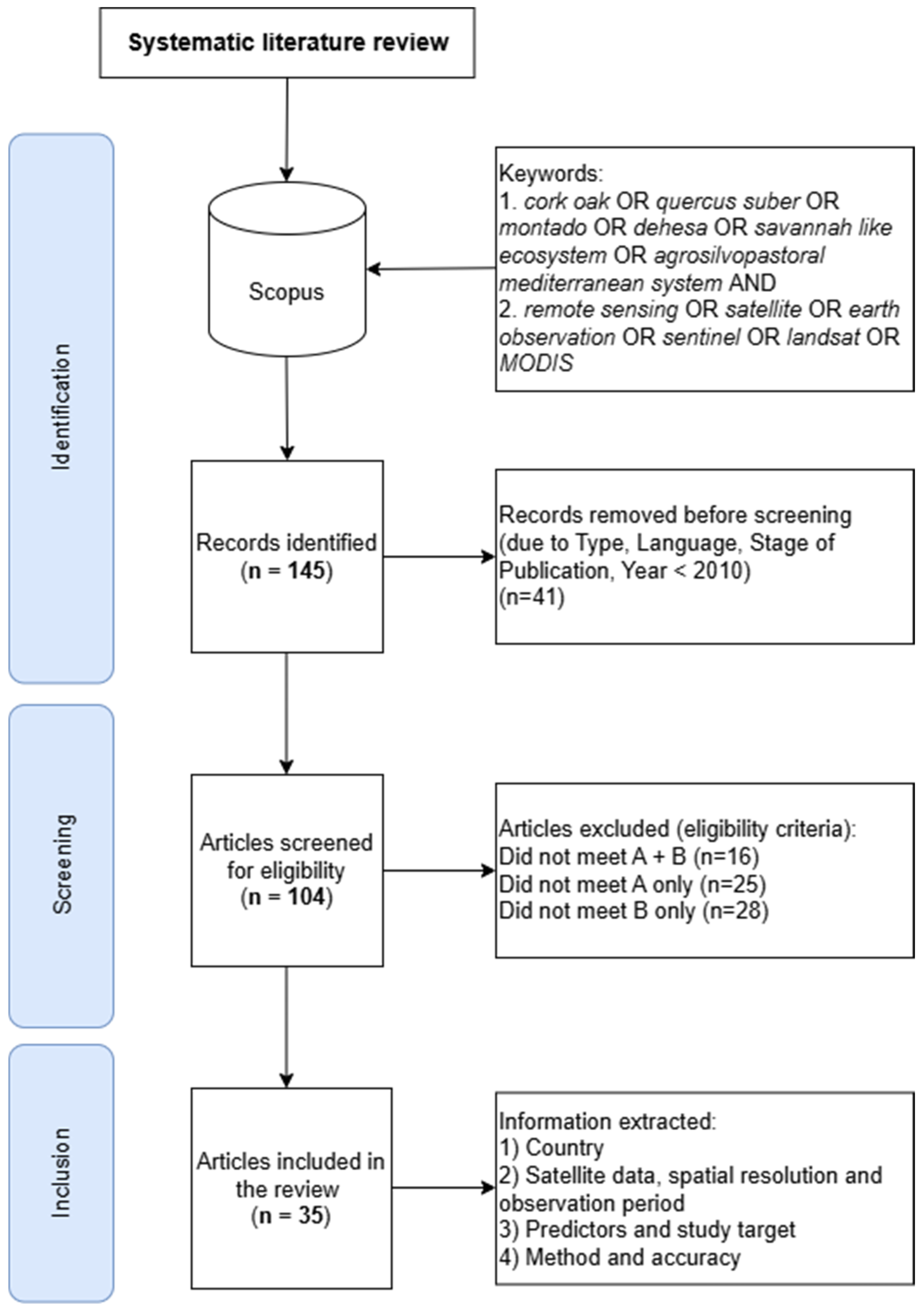
Figure 2. Systematic review workflow diagram. Criteria A: use of satellite-based remote sensing; criteria B: cork oak focus.
Diversity 17 00420 g002
Figure 3. Number of reviewed studies per country, based on the location of the area of interest.
Diversity 17 00420 g003
Figure 4. Distribution of studies by research object, aggregated by research topic. Classification (C), environmental variables (EVs), forest disturbances (FDs), forest variables (FV).
Diversity 17 00420 g004
Figure 5. Satellite data used in the analyzed papers grouped by publication period.
Diversity 17 00420 g005
Figure 6. Number of variables assessed through satellite-based data, grouped by research topic: C (classification), EVs (environmental variables), FD (forest disturbance), FVs (forest variables).
Diversity 17 00420 g006
Figure 7. Distribution of R2 (left) and OA (right) for the analyzed study variables, grouped by research topic (EV, FD, FV).
Diversity 17 00420 g007
Disclaimer/Publisher’s Note: The statements, opinions and data contained in all publications are solely those of the individual author(s) and contributor(s) and not of MDPI and/or the editor(s). MDPI and/or the editor(s) disclaim responsibility for any injury to people or property resulting from any ideas, methods, instructions or products referred to in the content.