Article

Biodiversity as a Tool in the Assessment of the Conservation Status of Coastal Habitats: A Case Study from Calabria (Southern Italy)

by
Antonio Morabito
1,
Carmelo Maria Musarella
1,
Giuseppe Caruso
1,2 and
Giovanni Spampinato
1,*
1
AGRARIA Department, University “Mediterranea” of Reggio Calabria, Feo di Vito, 89124 Reggio Calabria, Italy
2
Agricultural Technical Institute “V. Emanuele II”, via Cortese 1, 88100 Catanzaro, Italy
*
Author to whom correspondence should be addressed.
Diversity 2024, 16(9), 535; https://doi.org/10.3390/d16090535
Submission received: 1 July 2024 / Revised: 2 August 2024 / Accepted: 6 August 2024 / Published: 2 September 2024
(This article belongs to the Special Issue Biodiversity Conservation Planning and Assessment)

Abstract

:
The Mediterranean coasts are threatened by human activities that alter habitats structure and functionality, modifying vegetation and causing the loss of typical species. The definition of the conservation status of coastal habitats is essential to preserve these fragile environments through planned policies. This study aims to assess the conservation status of the habitats of community interest (sensu EEC Directive 43/92) through the analysis of biodiversity and correlating it with urbanisation. A total of 73 vegetation relevés were carried out, so allowing 13 revealing different habitats to be identified. The total plant species diversity per habitat was measured by means of the H-index, also used to assess naturalness (N), differently considering native, alien, and disturbance species. To correlate the N index with distance from urban centres, a statistical analysis was performed. The analysis showed the highest values of H+ were found in habitats 2240, 2110, 2260, and 2230, while lowest values were observed in habitats 2270* and 2240. The habitats 2270* and 2240, the closest to urban centres, have a lower naturalness score than habitats 1420, 2120, 2250*, and 2270*, where higher naturalness scores have been found and therefore lower levels of disturbance. The criteria and methods discussed in this study can be used in coastal management in order to identify the most sensitive habitats and implement an effective conservation strategy.

1. Introduction

Coastal ecosystems are typical transition ecosystems, linked to the interface between marine and terrestrial environments, usually with linear development, along the coastline, where environmental factors profoundly influence their dimensions, shape, and boundaries [1,2]. They are very dynamic ecosystems affected by strong environmental gradients, mainly related to the coherence of the substrate, salinity, wind, and salt spray, which vary with distance from the coastline and host a series of distinctive habitats of high conservation value, characterised by plant communities with relatively few but highly specialised and exclusive species [3,4].
In recent decades, habitats have been recognized to play an important role in biodiversity conservation and ecosystems functionality, so to deserve specific protection measures [5]. In the European Union, coastal habitats are of “Community interest” for the protection of European biodiversity and included in Annex I EU Habitats Directive (92/43/EEC), a fundamental legal tool in the European nature conservation policy. Furthermore, some of the habitats are “prioritary” in EU biodiversity conservation strategy [6].
Anthropogenic pressures on coastal ecosystems make them particularly vulnerable and highly endangered, as they are considered among the habitats most threatened by extinction [7,8]. From the 1950s to 1980s, coasts, especially across the Mediterranean basin, have been deeply anthropized, becoming very attractive tourist destinations [9] and useful areas for agriculture [10]. This has drastically changed the vegetation and ecological diversity formerly characterising these habitats [10,11], which have recently been included among those at the greatest risk of extinction [12].
The exploitation of the coastal zone for urbanisation and tourism has led to the decline and even extinction of typical coastal habitat species, at the same time promoting the rapid spread of synanthropic species, such as weedy and ruderal species adapted to urban environments [13], and the establishment of invasive species [14]. This has resulted in significant alterations of the structure and functionality of plant communities characterising coastal habitats, potentially threatening the extinction of the highly specialised and typical species [15,16,17]. The spread of invasive alien species is one of the most serious pressures on ecosystems, and one of the main threats to biodiversity conservation [14,18], especially for coastal ecosystems [19]. The establishment of synanthropic and invasive alien species in coastal ecosystems also causes serious changes in physical processes, and the loss of native species diversity reduces the ability of ecosystems to maintain their functioning in an environment increasingly affected by climate change [20,21].
From this perspective, habitat monitoring has considerable importance both in the assessment of the conservation status of the environment and to identify priorities and critical issues in coastal ecosystem management [22]. According to Carboni et al. [23], vegetation survey could help performing the assessment of biodiversity and conservation status of coastal habitats.
Mediterranean coastal ecosystems high ecological value is mainly due to both species diversity and environmental heterogeneity [24]. This implies that active management is always needed in areas globally considered crucial for biodiversity conservation, such as the Natura 2000 Network of the European Union [25]. Indicator species can be used to assess the conservation status of vegetation and habitats [26].
Several scientific approaches quantified habitat and vegetation human-induced change by applying indices such as species richness and diversity, in order to assess the conservation status of coastal habitats [27,28,29]. These can include habitat-specific specialist species and species associated with habitat degradation, such as synanthropic species.
At the habitat scale, alpha diversity can be estimated by considering species richness and species importance, and also used to evaluate the conservation status of a habitat and its naturalness; H’ dune is a plant diversity index to assess human impact on coastal dunes derived from the Shannon index of entropy [30]. The Shannon–Wiener diversity index (H+) [31] is often used in ecological studies, and vegetation analysis [32] can be applied to assess habitat conservation status and naturalness [33], distinguishing the contribution of typical and synanthropic/alien species to biodiversity.
The aim of this research, which takes as a case study the coastal habitats of Calabria(Southern Italy) is to propose a useful method for assessing the conservation status of coastal environments. The proposed methodology is biodiversity-based through the analysis of vegetation and landscape, also considering the impact of urbanisation on coastal habitats. The coastal habitats of Calabria are well suited for this study because they are quite well known thanks to many studies, mainly performed by various authors applying the phytosociological method [34,35,36,37,38,39]. Our study has three main objectives: (1) to evaluate the conservation status of coastal habitats by applying diversity indices to the plant assemblage; (2) to verify how the impact of urban centres affects the conservation of characteristic habitats and typical species; and (3) to test the effectiveness of this methodology based on landscape analysis using a Geographic Information System (GIS), and analysis of the habitat diversity through the study of vegetation.

2. Materials and Methods

This study was conducted on the coastal habitats of Calabria, a region in the centre of the Mediterranean basin, located in the southern Italian peninsula between the Ionian Sea to the east and the Tyrrhenian Sea to the west. The region has more than 700 km of coastline, most of which is sandy, partly affected by coastal erosion [40].
The analysis of coastal habitats was based on vegetation relevés carried out in the period 2018–2021, applying the phytosociological method of the Zurich–Montpellier school which consist in a list of plants in each homogeneous area, including the degree of coverage for each species expressed using the scale provided by Braun-Blanquet [41].
Seventy-three unpublished relevés with 261 species were carried out along the Calabrian coasts (Supplementary Materials File S1).
A multivariate analysis was performed on the matrix of phytosociological relevés for the definition of statistical-based coenological groups. To this end, the abundance–dominance value of each species reported with the Braun-Blanquet scale was converted to the numerical value scale proposed by Van der Mareel [42]. The softwares used for the organization of the raw data and the subsequent statistical analysis have been Microsoft Excel 2010; PASSED version 4.13; and R 4.1.1 R Core Team 2021.
The cluster analysis of the relevé matrix used the average linkage criterion (UPGMA) and the Chord distance algorithm to identify homogeneous floristic compositions. The interpretation of habitats was performed according to the literature [43,44,45].
From the Nature Map of the Calabria Region [46], all the polygons between 0 and 200 m a.s.l. (Figure 1) were extrapolated using the QGIS software (2023).
The distance in meters between the points of the relevés and the centre of the polygons coded as urban were calculated by QGIS.
According to the literature [47], the spatial model of dune plant communities was compared with quality and disturbance by plant community analyses.
Indicator species can be used to assess the conservation status of vegetation [48]. These can include habitat-specialised species and species associated with habitat degradation (e.g., synanthropic). Synanthropic species structure two main vegetation types: weedy vegetation and ruderal vegetation [49]. Weedy vegetation grows on crop land for agricultural purposes, while ruderal vegetation can be found in urban areas, and more generally in different human infrastructures, such as roads, railways, walls, industrial or commercial settlements, etc.
The total plant species diversity by habitat was measured with the Shannon–Wiener H+ index, one of the most used indices to estimate the species diversity of a biological community, combining species richness (the number of species in the community) and species evenness (how equal are the numbers of individuals of each species) [31].
H + = j = 1 s p i log p i
where pi = coverage of the i-th species compared to the entire community; S = number of species.
The total diversity does not provide information on the species types that make up the plant assemblage of the various habitats; typical or alien species can equally contribute. Different indices can be calculated to give a better indication of the flora. As highlighted by Grunewald and Schubert [30], Pinna et al. [29], and Caldaresi et al. [50], the Shannon–Wiener index (H+) allows the evaluation of levels of naturalness (N) of a habitat by distinguishing the biodiversity linked to autochthonous species and that due to alien species; we, on the other hand, also considered species linked to anthropic disturbance [51], i.e., species typical of synanthropic habitats (e.g., uncultivated land, ruderal environments, species infesting crops, etc.), reshaping the naturalness index as follows:
N   =   H + ( without   alien   and   disturbing   plant   species )   / H +
The naturalness index assumes values ranging 0 to 1, where 0 indicates that plant diversity consists entirely of alien and disturbance species, while 1 indicates the absence of the latter in the plant communities. Alien species were identified in accordance with the Portal to the Flora of Italy [52], while plant communities and disturbance species were verified considering the “Prodromo della Vegetazione d’Italia” [49] as well as the contributions of other authors [16,17,18,19,20,21,22,23,24,25,26,27,28,29,30,31,32,33,34,35,36,37,38,39,40,41]. In particular, the disturbance species were identified considering the characteristics of plant communities belonging to the anthropogenic vegetation of the phytosociological classes Stellarietea mediae Tüxen, Lohmeyer & Preising ex Von Rochow 1951 and Galio aparine-Urticetea dioicae Passarge ex Kopecký 1969 according to Biondi and Blasi [49].
To correlate the habitat naturalness index (N) with the average distances from urban centres (Ds), a statistical analysis was performed using PAST version 4.13, a linear regression model with Pearson’s correlation coefficients, and the Durbin–Watson and Breusch–Pagan tests. [53,54,55,56].

3. Results

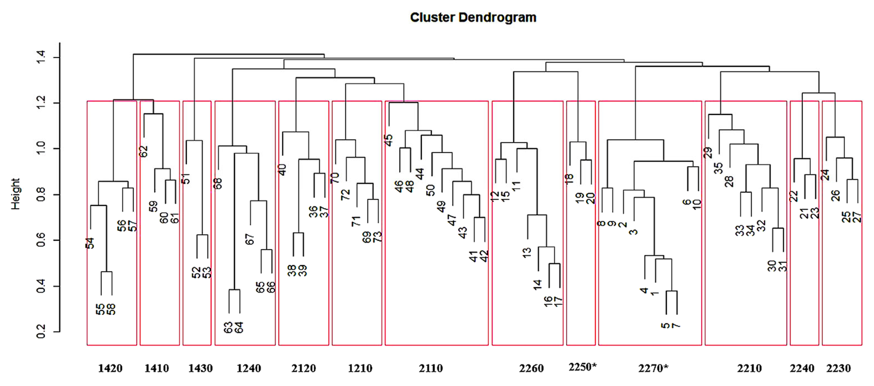
Cluster analysis of the vegetation matrix produced the dendrogram in Figure 2, where the abscissa represents the distinguishing number of each survey, and the ordinate represents the similarity scale. The first subdivision is at a similarity level of 1.4 and separates the typically halophilic habitats of brackish depressions from the others. The subsequent subdivisions (similarity coefficient 1.2) shows a total of 13 groups of relevés, each corresponding to a specific habitat type according to Annex 1 of European Directive 43/92.
Table 1 show the EEC 92/43 habitats identified by means of the cluster analysis. For each habitat, indicated by the code and the name of Annex I of the EEC Directive 92/43, the following information is provided: a brief description, the typical species present in the analysed relevés (Supplementary Material File S1) with the scientific names updated according to the “Portal to the Flora of Italy” [52], and the reference phytosociological syntaxa according to Biondi et al. [43]. In File S2 (Supplementary Material) the syntaxonomic scheme of the cited syntaxa is reported, updated according to the ‘Prodromo della Vegetazione d’Italia’ [49].
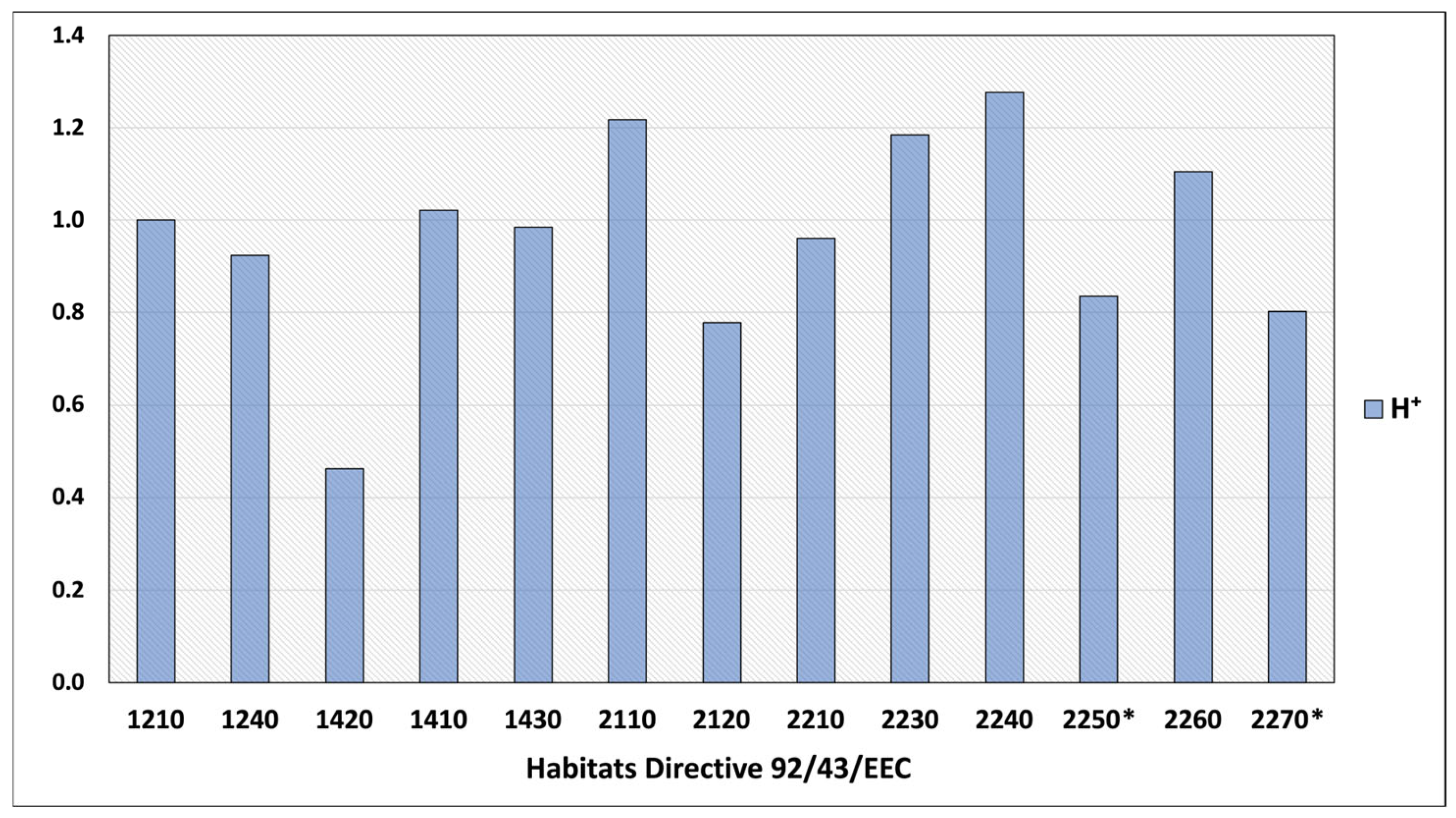
The biodiversity values of the coastal habitats compared (Table 2, Figure 3) show that the Shannon–Wiener index (H+) is higher for habitats 2240, 2110, 2260, and 2230. Lower values were found in habitats 1420, 2120, 2250*, and 2270*.
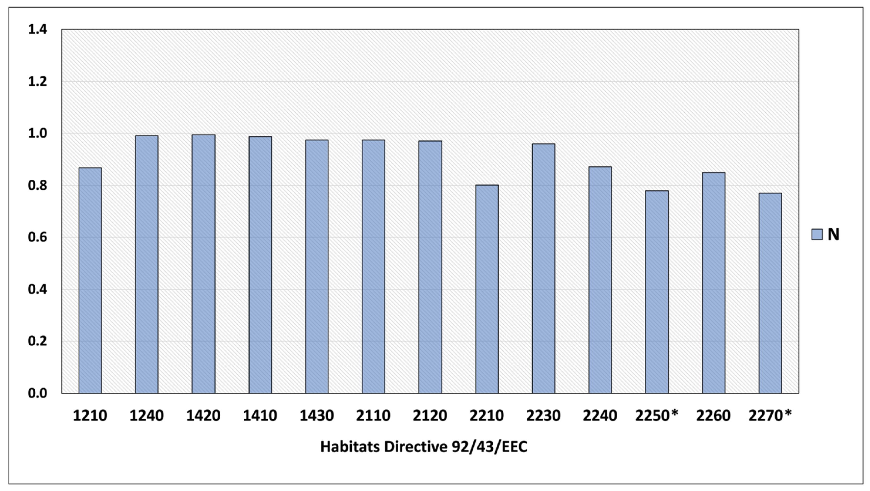
The highest values of the naturalness index (N), equal to 1, were found in habitats 1240, 1420, 1410, 2110, and 2230 (Figure 4), while the lowest values, around 0.8, were observed for habitats 2270*, 2250*, and 2210, which were found to be more susceptible to disturbance as they host a high number of synanthropic species such as Cynodon dactylon (L.) Pers., Galactites tomentosus Moench, Reichardia picroides (L.) Roth, Pallenis spinosa (L.) Cass., and alien species such as Acacia saligna (Labill.) H.L.Wendl., Carpobrotus acinaciformis (L.) L.Bolus, Erigeron canadensis L., Oxalis pes-caprae L., and Pittosporum tobira (Thunb.) W.T. Aiton.
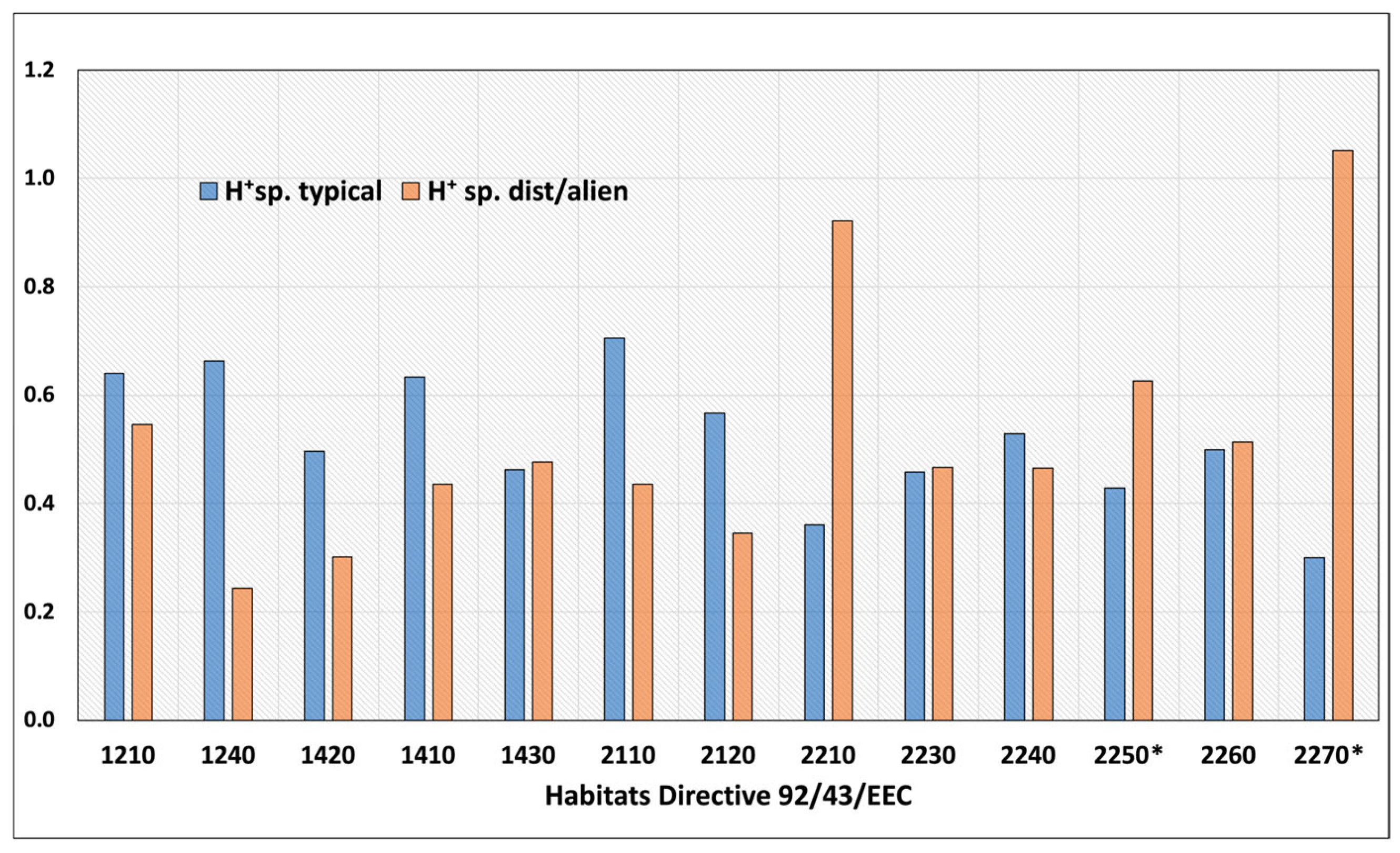
Figure 5 shows that in habitats 2270*, 2250*, 2230, and 2210 the H+ values of disturbance species (H+dist./alien) are higher than the H+ values of typical species (H+ typical), unlike habitats 2110, 2120, 1210, 1240, 1410, and 1420, where the greatest diversity (H+) is represented by typical species.
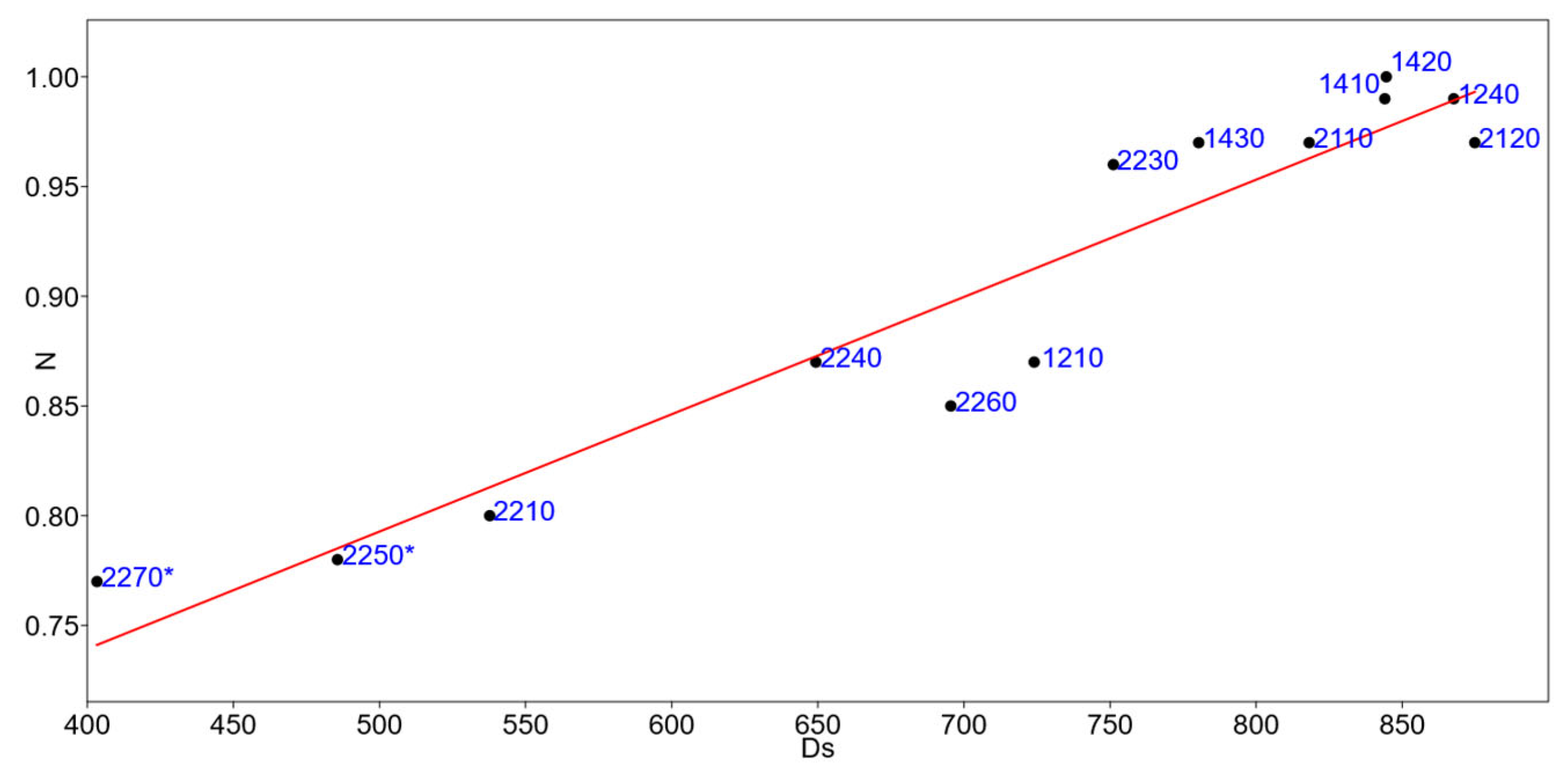
The linear correlation analysis r (Pearson) between the naturalness index values (N) and the average distances (Ds) between the relevés carried out and the polygons coded as urban centres shows a strong significance for the two variables with p-value < 0.05 (1.03 × 10⁻⁷).
For the statistical analysis, a linear regression model (Figure 6) was applied between the mean distances and the naturalness index (N). Although the number of cases is not very high, the model shows a significant slope p-value < 0.05 (0.00000048404), and a correlation of 0.96. (Supplementary Materials, File S3).
This analysis shows that the naturalness of habitats increases with increasing distance from polygons coded as urban, confirming that the closest habitats to urban areas are those most impacted by human activity.
To verify the autocorrelation analyses, the Durbin–Walson statistical test was applied with a value of 1.83 and a probability of autocorrelation of 0.45 (p > 0.05), while the variance of the residuals and therefore the homoscedasticity was calculated with the Breusch–Pagan test, with a value of 0.01 and a probability of homoscedasticity of 0.91 (p > 0.05). (Supplementary Materials File S4)
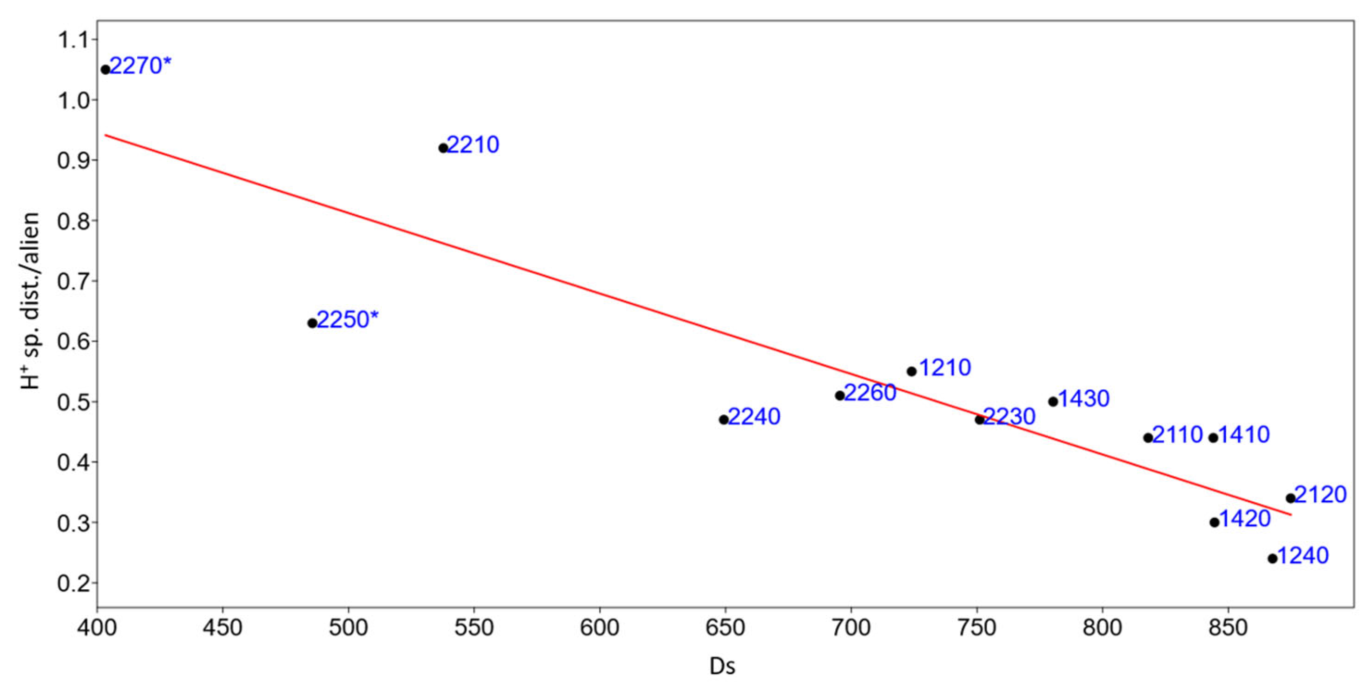
The linear correlation r (Pearson) was also applied between the percentage values obtained from the diversity index H + of the disturbance and alien species, and the values of the average distances with a significant correlation of 0.03, p < 0.05.
In Figure 7, a linear regression model is applied between the average distances (Ds), and the percentage of Shannon–Wiener index (H+) values obtained only by considering the disturbance species including aliens. Although the number of cases is not very high, the model shows a significant slope p-value < 0.05 (0.02), and a 0.6 correlation. This analysis agrees with the previous one showing that the presence of ruderal and alien species decreases with increasing distance from urban centres.
In order to verify the autocorrelation analysis, the Durbin–Walson statistical test was applied with a value of 1.34 and a probability of autocorrelation of 0.14% (p > 0.05), while the variance of the residuals and therefore the homoscedasticity was calculated with the Breusch–Pagan test, with a value of 3.65 and a probability of homoscedasticity of 0.5 (p > 0.05).
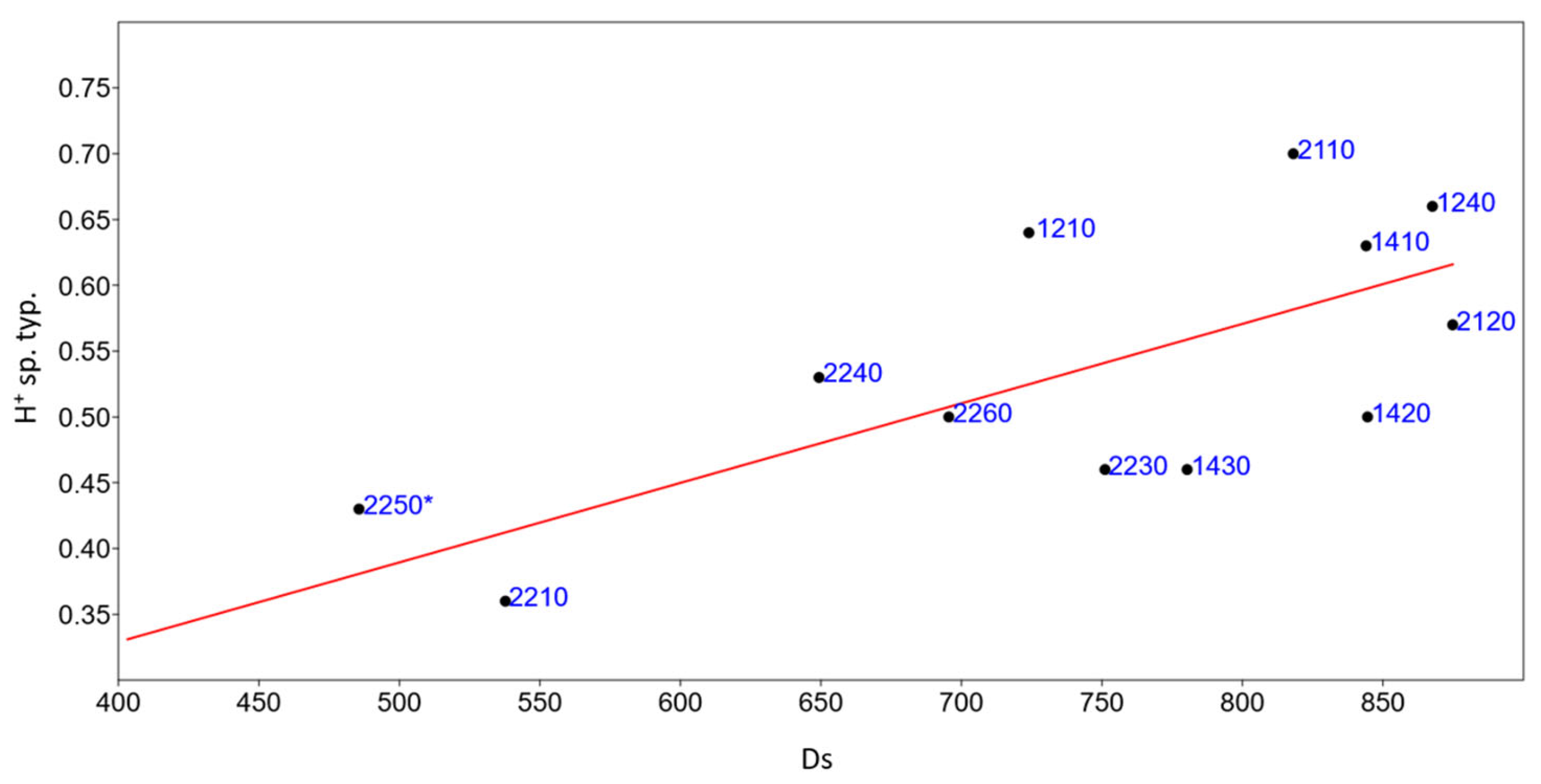
Linear correlation analysis r (Pearson) shows a strong significance for the two variables with p-values < 0.05 (0.01).
A linear regression model (Figure 8) is applied between the average distances (Ds), and the percentage of the Shannon–Wiener index taking into account typical species (H+ sp. Typ.). The model shows a significant slope p-value < 0.05 (0.01), and a correlation of 0.7 (Supplementary Materials, File S5). This analysis is consistent with previous ones, showing that typical habitat reference species increase with increasing distance from urban centres and are therefore less impacted by human activity.

4. Discussion

Coastal habitats are particularly fragile and highly threatened environments, which implies the need for active monitoring and management of these habitats.
In this study, vegetation analysis proved to be an excellent tool in the identification and assessment of the conservation status of coastal habitats. The occurrence of different plant communities, characteristic of different habitat types, was found along the Calabrian coasts. The distribution of these communities generally follows the succession typical of other Mediterranean coasts: on sandy coasts, the succession of habitats begins with annual vegetation near the coastline (habitat 1210) and continues inland with psammophilous herbaceous communities of embryonic and mobile dunes (habitat 2110; 2120), then fixed dunes (habitat 2210), interspersed with annual herbaceous phytocoenoses (habitats 2230; 2240) up to shrub or forest communities on stabilised dunes (2250*; 2260 and 2270*).
The analysis of plant community diversity using the naturalness index (N) proved to be very interesting in assessing the impact of anthropisation on coastal habitats, conversely to what has been shown in other studies [57]. In fact, the low values of the naturalness index (N) are not only due to the presence of alien taxa in the study area, but also to the presence of synanthropic species, which are indicators of disturbance.
The analysis shows that coastal habitats closer to urban centres show low naturalness values and a higher contribution to total diversity from exotic and disturbance species, highlighting that, in agreement with other studies [57], urbanisation and invasive non-native species constitute the most important threats to coastal habitats not only in open environments but also in more stabilised ecosystems, such as grey dunes and forests. Among these, we can observe habitat 2270*, 2250*, and 2210, the latter in agreement with other studies [58], are considered the most sensitive to anthropogenic disturbance. Several studies (European Commission 2008) [12] have shown that habitat 2210—Crucianellion maritimae fixed beach dunes—is considered at risk in all Mediterranean coasts. Meanwhile, habitat 2250*, in accordance with Acosta et al. [59], in Calabria is also currently limited to the few coastal stretches not exploited for tourist or residential purposes.
The results obtained show that in habitat 2270* synanthropic species are particularly widespread and this agrees with what has been observed in other territories by Bonari et al. [60] and Sarmati et al. [61]. Probably one of the main vectors in the establishment of these weeds and ruderal communities is trampling resulting from tourist exploitation. Habitat 2250* also has a bad conservation status, in agreement with other studies [11], and shows a marked reduction in area due to human activity.
According to Acosta et al. [62], the species richness of coastal dune habitats is maximum in the intermediate dune, and the diversity in the inland area is more characterized by synanthropic species such as therophytes or chamaephytes.
The presence and spread of alien species within wooded dunes is another critical issue for the protection of coastal habitats, altering their diversity in different ecosystems [63], including Acacia saligna, which is used for reforestation and produces litter that takes a long time to decompose, negatively affecting soil availability.

5. Conclusions

Coastal ecosystems are dynamic systems influenced by both natural and anthropogenic pressures, which have increasingly intensified in recent decades, resulting in changes in plant communities and landscapes. This relationship can be used as a monitoring tool in coastal habitats. Plant communities, which represent a well-identifiable component of habitats with relatively stable composition, structure, and interrelationships, all of which are linked to specific environmental conditions, can provide a reliable basis for monitoring activities. Habitat vegetation analysis and environmental analysis through a GIS can provides a complete picture of the naturalness, allowing us to recognise the conservation status of coastal habitats.
Our results show that priority should be given to, and monitoring activities should focus primarily on wooded dune habitats and stable dunes near urban centres, due to the presence of alien and disturbance species that affect these habitats, causing a reduction in biodiversity and posing a threat to the conservation of these habitats. The application of diversity indices linked to landscape analysis are therefore suitable for identifying the causes of alteration due to invasive and disturbance species and can also be used to monitor and assess the conservation status of habitats of community interest. This methodology summarises the conservation status of coastal vegetation in a standardised, objective, and repeatable way over the years to assess the effects of management changes, through the analysis of plant community and the use of different diversity indicators. Overall, it can be a valuable support for the implementation of a conservation strategy compatible with the integrated management of Mediterranean coastal ecosystems.

Supplementary Materials

The following supporting information can be downloaded at: https://www.mdpi.com/article/10.3390/d16090535/s1, File S1—Phytosociological relevés; File S2—Syntaxonomic scheme; File S3—Linear regression model between naturalness index (N) and mean distances (Ds) between habitat types and polygons coded as urban; File S4—Linear regression model between average distances from urban centres (Ds) and % H+ values of typical species (H+ sp. typ.) including aliens for each habitat types; File S5—Linear regression model between average distances from urban centres (Dist.) and % H+ values of typical species (H+ sp. dist./alien) including aliens for each habitat types.

Author Contributions

Conceptualization, A.M., G.S. and C.M.M.; methodology, A.M. and G.S.; software, A.M.; analysis, A.M.; data curation, A.M.; writing—original draft preparation, A.M.; writing—review and editing, C.M.M., G.C. and G.S.; supervision, G.S.; funding acquisition, G.S. All authors have read and agreed to the published version of the manuscript.

Funding

This research was partially supported by the “Nature Map System” project signed between the AGRARIA Department—Mediterranean University of Reggio Calabria and the Territory and Environment Department of Calabria Region, Sector 5, Parks and Protected Natural Areas, under the Regional Operational Program (ROP) 2014/2020—Action 6.5.A.1—Actions provided for in the Prioritez Action Framework (PAF) and in the Natura 2000 Network Management Plans, scientific manager Giovanni Spampinato.

Institutional Review Board Statement

Not applicable.

Data Availability Statement

The original contributions presented in the study are included in the article.

Conflicts of Interest

The authors declare no conflict of interest.

References

  1. McLachlan, A.; Brown, A.C. The Ecology of Sandy Shores; Academic Press: Burlington, VT, USA, 2006. [Google Scholar]
  2. Glemarec, E.; Bioret, F. Assessment of the dynamic trajectories and maritime character of Armorican cliff-top coastal heathlands. Plant Sociol. 2023, 60, 1–24. [Google Scholar] [CrossRef]
  3. Acosta, A.; Ercole, S.; Stanisci, A.; Pilastro, V.D.P.; Blasi, C. Zonazione della vegetazione costiera e morfologia delle dune in alcuni ecosistemi mediterranei. J. Coast. Res. 2007, 23, 1518–1524. [Google Scholar] [CrossRef]
  4. Marcenò, C.; Guarino, R.; Loidi, J.; Herrera, M.; Isermann, M.; Knollová, I.; Tichý, L.; Tzonev, R.T.; Acosta, A.T.R.; FitzPatrick, Ú.; et al. Classification of European and Mediterranean coastal dune vegetation. Appl. Veg. Sci. 2018, 21, 533–559. [Google Scholar] [CrossRef]
  5. Bonari, G.; Fantinato, E.; Lazzaro, L.; Sperandii, M.G.; Acosta, A.T.R.; Allegrezza, M.; Assini, S.; Caccianiga, M.; Di Cecco, V.; Frattaroli, A.; et al. Shedding light on typical species: Implications for habitat monitoring. Plant Sociol. 2021, 58, 157–166. [Google Scholar] [CrossRef]
  6. Feola, S.; Carranza, M.L.; Schaminée, J.H.J.; Janssen, J.A.M.; Acosta, A.T.R. EU habitats of interest: An insight into Atlantic and Mediterranean beach and foredunes. Biodivers. Conserv. 2011, 20, 1457–1468. [Google Scholar] [CrossRef]
  7. Cardinale, B.J.; Duffy, J.E.; Gonzalez, A.; Hooper, D.U.; Perrings, C.; Venail, P.; Narwani, A.; Mace, G.M.; Tilman, D.; Wardle, D.A.; et al. Biodiversity loss and its impact on humanity. Nature 2012, 486, 59. [Google Scholar] [CrossRef]
  8. van Rooijen, N.M.; de Keersmaecker, W.; Ozinga, W.A.; Coppin, P.; Hennekens, S.M.; Schaminée, J.H.J.; Somers, B.; Honnay, O. Plant Species Diversity Mediates Ecosystem Stability of Natural Dune Grasslands in Response to Drought. Ecosystems 2015, 18, 1383–1394. [Google Scholar] [CrossRef]
  9. Malavasi, M.; Santoro, R.; Cutini, M.; Acosta, A.; Carranza, M.L. The impact of human pressure on landscape patterns and plant species richness in Mediterranean coastal dunes. Plant Biosyst.-Int. J. Deal. Asp. Plant Biol. 2014, 150, 73–82. [Google Scholar] [CrossRef]
  10. Sciandrello, S.; Musarella, C.M.; Puglisi, M.; Spampinato, G.; Tomaselli, V.; Minissale, P. Updated and new insights on the coastal halophilous vegetation of southeastern Sicily (Italy). Plant Sociol. 2019, 56, 81–98. [Google Scholar] [CrossRef]
  11. Prisco, I.; Angiolini, C.; Assini, S.; Buffa, G.; Gigante, D.; Marcenò, C.; Sciandrello, S.; Villani, M.; Acosta, A.T.R. Conservation status of Italian coastal dune habitats in the light of the 4th monitoring report (92/43/EEC habitats directive). Plant Sociol. 2020, 57, 55–64. [Google Scholar] [CrossRef]
  12. Janssen, J.A.M.; Rodwell, J.S.; García Criado, M.; Gubbay, S.; Haynes, T.; Nieto, A.; Sanders, N.; Landucci, F.; Loidi, J.; Ssymank, A.; et al. European Red List of Habitats. Part 2, Terrestrial and Freshwater Habitats; Publications Office of the European Union: Luxembourg, 2016. [Google Scholar]
  13. Carranza, M.L.; Drius, M.; Marzialetti, F.; Malavasi, M.; de Francesco, M.C.; Acosta, A.T.R.; Stanisci, A. Urban expansion depletes cultural ecosystem services: An insight into a Mediterranean coastline. Rend. Lince-Sci. Fis. Nat. 2020, 31, 103–111. [Google Scholar] [CrossRef]
  14. Musarella, C.M.; Laface, V.L.A.; Angiolini, C.; Bacchetta, G.; Bajona, E.; Banfi, E.; Barone, G.; Biscotti, N.; Bonsanto, D.; Calvia, G.; et al. New Alien Plant Taxa for Italy and Europe: An Update. Plants 2024, 13, 620. [Google Scholar] [CrossRef] [PubMed]
  15. Vitti, S.; Pellegrini, E.; Casolo, V.; Trotta, G.; Boscutti, F. Contrasting responses of native and alien plant species to soil properties shed new light on the invasion of dune systems. J. Plant Ecol. 2020, 13, 667–675. [Google Scholar] [CrossRef]
  16. Lami, F.; Vitti, S.; Marini, L.; Pellegrini, E.; Casolo, V.; Trotta, G.; Sigura, M.; Boscutti, F. Habitat type and community age as barriers to alien plant invasions in coastal species-habitat networks. Ecol. Indic. 2021, 133, 108450. [Google Scholar] [CrossRef]
  17. Simberloff, D.; Martin, J.-L.; Genovesi, P.; Maris, V.; Wardle, D.A.; Aronson, J.; Courchamp, F.; Galil, B.; García-Berthou, E.; Pascal, M.; et al. Impacts of biological invasions: What’s what and the way forward. Trends Ecol. Evol. 2013, 28, 58–66. [Google Scholar] [CrossRef]
  18. Buffa, G.; Fantinato, E.; Pizzo, L. Effects of disturbance on sandy coastal ecosystems of N-Adriatic coasts (Italy). In Biodiversity Enrichment in a Diverse World; Lameed, G.A., Ed.; InTech: Rijeka, Croatia, 2012; pp. 339–372. [Google Scholar]
  19. Tordoni, E.; Petruzzellis, F.; Nardini, A.; Savi, T.; Bacaro, G. Make it simpler: Alien species decrease functional diversity of coastal plant communities. J. Veg. Sci. 2019, 30, 498–509. [Google Scholar] [CrossRef]
  20. Carboni, M.; Santoro, R.; Acosta, A.T.R. Are some communities of the coastal dune zonation more susceptible to alien plant invasion? J. Plant Ecol. 2010, 3, 139–147. [Google Scholar] [CrossRef]
  21. Genovesi, P.; Angelini, P.; Bianchi, E.; Dupré, E.; Ercole, S.; Giacanelli, V.; Ronchi, F.; Stoch, F. Specie e Habitat di Interesse Comunitario in Italia: Distribuzione, stato di Conservazione e Trend; Serie Rapporti 194/2014; ISPRA: Rome, Italy, 2014. [Google Scholar]
  22. Ostermann, O.P. The need for management of nature conservation sites designated under Natura 2000. J. Appl. Ecol. 1998, 35, 968–973. [Google Scholar] [CrossRef]
  23. Carboni, M.; Carranza, M.L.; Acosta, A.T.R. Assessing conservation status on coastal dunes: A multiscale approach. Landsc. Urban. Plan. 2009, 91, 17–25. [Google Scholar] [CrossRef]
  24. Biondi, E. Riflessioni sull’ecologia e sulla sintassonomia di alcune tipologie vegetali della costa mediterranea. Fitosociologia 2007, 44, 3–10. [Google Scholar]
  25. Lazzaro, L.; Bolpagni, R.; Buffa, G.; Gentili, R.; Lonati, M.; Stinca, A.; Acosta, A.T.R.; Adorni, M.; Aleffi, M.; Allegrezza, M.; et al. Impact of invasive alien plants on native plant communities and Natura 2000 habitats: State of the art, gap analysis and perspectives in Italy. J. Environ. Manag. 2020, 274, 111140. [Google Scholar] [CrossRef]
  26. Siddig, A.A.H.; Ellison AMOchs, A.; Villar-Leeman, C.; Lau, M.K. How do ecologists select and use indicator species to monitor ecological change? Insights from 14 years of publication in Ecological Indicators. Ecol. Indic. 2016, 60, 223–230. [Google Scholar] [CrossRef]
  27. Pretto, F.; Celesti-Grapow, L.; Carli, E.; Brundu, G.; Blasi, C. Determinants of non-native plant species richness and composition across small Mediterranean islands. Biol. Invasions 2012, 14, 2559–2572. [Google Scholar] [CrossRef]
  28. van der Hagen, H.G.; Lammers, E.; van der Meulen, F.; Pätsch, R.; van Rooijen, N.M.; Sýkora, K.V.; Schaminée, J.H. The role of livestock grazing in long-term vegetation changes in coastal dunes: A case study from the Netherlands. Plant Sociol. 2023, 60, 1–12. [Google Scholar] [CrossRef]
  29. Pinna, M.S.; Bacchetta, G.; Cogoni, D.; Fenu, G. Is vegetation an indicator for evaluating the impact of tourism on the conservation status of Mediterranean coastal dunes? Sci. Total Environ. 2019, 674, 255–263. [Google Scholar] [CrossRef]
  30. Grünewald, R.; Schubert, H. The definition of a new plant diversity index “H′ dune” for assessing human damage on coastal dunes–derived from the Shannon index of entropy H′. Ecol. Indic. 2007, 7, 1–21. [Google Scholar] [CrossRef]
  31. Shannon, C.E.; Weaver, W. A Mathematical Theory of Communication; University of Illinois Press: Urbana, IL, USA, 1949. [Google Scholar]
  32. Kent, M.; Coker, P.; Kershaw, K.A. Vegetation description and analysis: A practical approach. In Quantitative and Dynamic Plant Ecology, 2nd ed.; Edward Arnold publishers, Ltd.: New York, NY, USA; London, UK, 1992; p. 363. [Google Scholar]
  33. Del Vecchio, S.; Slaviero, A.; Fantinato, E.; Buffa, G. The use of plant community attributes to detect habitat quality in coastal environments. AoB Plants 2016, 8, plw040. [Google Scholar] [CrossRef]
  34. Brullo, S.; Scelsi, F.; Spampinato, G. La Vegetazione dell’Aspromonte. Studio Fitosociologico; Laruffa Editore: Reggio Calabria, Italy, 2001. [Google Scholar]
  35. Maiorca, G.; Spampinato, G.; Caprio, A. Flora e vegetazione dei laghi costieri La Vota (Calabria centro-occidentale). Fitosociologia 2002, 39, 81–108. [Google Scholar]
  36. Caridi, D.; Maiorca, G.; Spampinato, G.; Cameriere, P.; Crisafulli, A. Analisi diacronica della vegetazione della riserva “Foce del Fiume Crati” (Calabria, Italia). In Proceedings of the Atti 10° Conferenza ASITA, Bolzano, Italy, 14–17 September 2006; pp. 539–544. [Google Scholar]
  37. Maiorca, G.; Spampinato, G.; Crisafulli, A.; Cameriere, P. Flora vascolare e vegetazione della Riserva Naturale Regionale Foce del Fiume Crati (Calabria Italia meridionale) Webbia. J. Plant Taxon. Geogr. 2007, 62, 121–174. [Google Scholar]
  38. Caruso, G. Andar per Piante tra Terra e Mare. Escursioni Botaniche Sulle Coste della Calabria; Koeltz Scientific Books: Oberreifenberg, Germany, 2015. [Google Scholar]
  39. Maiorca, G.; Crisafulli, A.; Puntillo, D.; Signorino, G.; Spampinato, G. Wetland vegetation of the Tarsia Lake Regional Nature Reserve (Calabria, southern Italy). Medit. Bot. 2020, 41, 67–84. [Google Scholar]
  40. Foti, G.; Barbaro, G.; Besio, G.; Barillà, G.C.; Mancuso, P.; Puntorieri, P. Wave Climate along Calabrian Coasts. Climate 2022, 10, 80. [Google Scholar] [CrossRef]
  41. Braun-Blanquet, J. Pflanzensoziologie. Grundzüge der Vegetationskunde, 3rd ed.; Springer: Vienna, Austria, 1964. [Google Scholar] [CrossRef]
  42. Van der Maarel, E. Trasformation of cover-abundance values in phytosociology and its effects on community similarity. Vegetatio 1979, 39, 97–144. [Google Scholar]
  43. Biondi, E.; Blasi, C.; Burrascano, S.; Casavecchia, S.; Copiz, R.; Del Vico, E.; Galdenzi, D.; Gigante, D.; Lasen, C.; Spampinato, G.; et al. Manuale Italiano di Interpretazione degli Habitat della Direttiva 92/43 /CEE. Società Botanica Italiana—Ministero dell’Ambiente e della tutela del Territorio e del Mare, Direzione Protezione della Natura. 2009. Available online: http://vnr.unipg.it/habitat/ (accessed on 4 June 2024).
  44. Angelini, P.; Casella, L.; Grignetti, A.; Genovesi, P. Manuali per il Monitoraggio di Specie e Habitat di Interesse Comunitario (Direttiva 92/43/CEE) in Italia: Habitat; ISPRA, Serie Manuali e Linee Guida, 142/2016; Istituto Superiore Per la Ricerca Ambientale: Rome, Italy, 2016. [Google Scholar]
  45. Chytrý, M.; Tichý, L.; Hennekens, S.M.; Knollová, I.; Janssen, J.A.; Rodwell, J.S.; Schaminée, J.H. EUNIS Habitat Classification: Expert system, characteristic species combinations and distribution maps of European habitats. Appl. Veg. Sci. 2020, 23, 648–675. [Google Scholar] [CrossRef]
  46. Aramini, G.; Bernardo, L.; Spampinato, G. (Eds.) Carta Natura. Geografia degli Habitat. Monografia Calabria; Arti Grafiche Cardamone: Decollatura, Italy, 2023. [Google Scholar]
  47. Acosta, A.; Blasi, C.; Carranza, M.L.; Ricotta, C.; Stanisci, A. Quantifying ecological mosaic connectivity and hemeroby with a new topoecological inde. Phytocoenologia 2003, 33, 623–631. [Google Scholar] [CrossRef]
  48. Silva, V.; Catry, F.X.; Fernandes, P.M.; Rego, F.C.; Paes, P.; Nunes, L.; Caperta, A.D.; Sérgio, C. Effects of grazing on plant composition, conservation status and ecosystem services of Natura 2000 shrub-grassland habitat types. Biodivers. Conserv. 2019, 28, 1205–1224. [Google Scholar] [CrossRef]
  49. Biondi, E.; Blasi, C. Prodromo della Vegetazione Italiana. MATTM, SBI. 2015. Available online: www.prodromo-vegetazione-italia.org (accessed on 4 June 2024).
  50. Calderisi, G.; Cogoni, D.; Loni, A.; Fenu, G. Difference between invasive alien and native vegetation in trapping beach litter: A focus on a typical sandy beach of W-Mediterranean Basin. Mar. Pollut. Bull. 2023, 192, 115065. [Google Scholar] [CrossRef] [PubMed]
  51. Morabito, A.; Musarella, C.M.; Spampinato, G. Diversity and Ecological Assessment of Grasslands Habitat Types: A Case Study in the Calabria Region (Southern Italy). Land 2024, 13, 719. [Google Scholar] [CrossRef]
  52. Portal to the Flora of Italy. 2023. Available online: http://dryades.units.it/floritaly (accessed on 4 June 2024).
  53. Farebrother, R.W. Pan’s procedure for the tail probabilities of the Durbin-Watson statistic. Appl. Stat. 1980, 29, 224–227. [Google Scholar] [CrossRef]
  54. Rousseeuw, P.J.; van Driessen, K. Computing LTS Regression for Large Data Sets. Data Min. Knowl. Discov. 2006, 12, 29–45. [Google Scholar] [CrossRef]
  55. Warton, D.I.; Wright, I.J.; Falster, D.S.; Westoby, M. Bivariate line-fitting methods for allometry. Biol. Rev. 2006, 81, 259–291. [Google Scholar] [CrossRef]
  56. Wooldridge, J.M. Introductory Econometrics—A Modern Approach, 5th ed.; Michigan State University: East Lansing, MI, USA, 2013. [Google Scholar]
  57. Ciccarelli, D. Mediterranean Coastal Sand Dune Vegetation: Influence of Natural and Anthropogenic Factors. Environ. Manag. 2014, 54, 194–204. [Google Scholar] [CrossRef] [PubMed]
  58. Šilc, U.; Stešević, D.; Luković, M.; Caković, D. Changes of a sand dune system and vegetation between 1950 and 2015 on Velika plaža (Montenegro, E Mediterranean). Reg. Stud. Mar. Sci. 2020, 35, 101139. [Google Scholar] [CrossRef]
  59. Acosta, A.; Ercole, S. (Eds.) Gli Habitat delle Coste Sabbiose Italiane: Ecologia e Problematiche di Conservazione; Serie Rapporti, 215/2015; ISPRA: Rome, Italy, 2015. [Google Scholar]
  60. Bonari, G.; Acosta, A.T.R.; Angiolini, C. Mediterranean coastal pine forest stands: Understorey distinctiveness or not? For. Ecol. Manag. 2017, 391, 19–28. [Google Scholar] [CrossRef]
  61. Sarmati, S.; Bonari, G.; Angiolini, C. Conservation status of Mediterranean coastal dune habitats: Anthropogenic disturbance may hamper habitat assignment. Rendiconti Lincei. Sci. Fis. Nat. 2019, 30, 623–636. [Google Scholar] [CrossRef]
  62. Acosta, A.T.R.; Carranza, M.L.; Izzi, C.F. Are there habitats that contribute best to plant species diversity in coastal dunes? Biodivers. Conserv. 2009, 18, 1087–1098. [Google Scholar] [CrossRef]
  63. Calabrese, V.; Frate, L.; Iannotta, F.; Prisco, I.; Stanisci, A. Acacia saligna: Specie invasiva delle coste molisane. Forest 2017, 14, 28–33. [Google Scholar] [CrossRef]
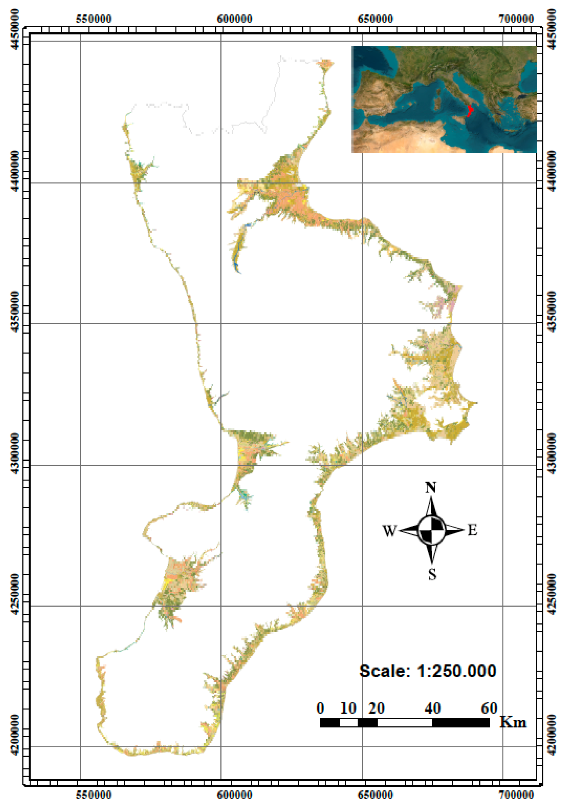
Figure 1. Study area with highlighted Nature Map habitats of the Calabria region extrapolated in the altitudinal range 0-200 m a.s.l.
Diversity 16 00535 g001
Figure 2. Dendrogram derived from cluster analysis on matrix relevés (Chord as distance coefficient and UPGMA as clustering algorithm) showing 13 habitat types (see Table 1).
Diversity 16 00535 g002
Figure 3. Biodiversity values of Shannon–Wiener index (H+) in the coastal habitat types. (* priority habitat type in accordance with Directive 92/43/EEC).
Diversity 16 00535 g003
Figure 4. Values of the naturalness index (N) the coastal habitat types. (* priority habitat type in accordance with Directive 92/43/EEC).
Diversity 16 00535 g004
Figure 5. H+ index values of typical species (H+ sp. typical) and of disturbance and alien species (H+ sp. dist/alien) in the coastal habitat types. (* priority habitat type in accordance with Directive 92/43/EEC).
Diversity 16 00535 g005
Figure 6. Linear regression model between naturalness index (N) versus average distances from urban centres in metres (Ds) between habitat types and polygons coded as urban (* priority habitat type in accordance with Directive 92/43/EEC).
Diversity 16 00535 g006
Figure 7. Linear regression model between average distances from urban centres (Ds) versus % H+ values of typical species (H+ sp. typical) including aliens for each habitat types. (* priority habitat type in accordance with Directive 92/43/EEC).
Diversity 16 00535 g007
Figure 8. Linear regression model between average distances from urban centres (Ds) and percentages of Shannon–Wiener diversity index due to alien and disturbance species (H+dist./alien) for each habitat types. (* priority habitat type in accordance with Directive 92/43/EEC).
Diversity 16 00535 g008
Table 1. Main characteristics of identified habitat types of community interest by the cluster analysis. (* priority habitat type in accordance with Directive 92/43/EEC).
Habitat
Directive
DescriptionTypical SpeciesSintaxa
1210—Annual vegetation of drift linesSandy or shingle beaches with little or no vegetation.Cakile maritima subsp. maritima, Euphorbia peplis, Glaucium flavum, Polygonum maritimum, Salsola squarrosa.Salsolo kaliCakiletum maritimae Costa & Manzanet 1981 nom. mut. propos. in Rivas-Martínez et al. 2002
1240—Vegetated sea cliffs of the Mediterranean coasts with endemic Limonium spp.Rocky shores with discontinuous and sparse vegetation, characterised by stenoendemic species of the genus Limonium and Crithmum maritimum.Limonium calabrum, Limonium remotispiculum, Crithmum maritimum, Limbarda crithmoides subsp. longifolia, Allium commutatum, Hyoseris lucida L. subsp. taurina.Crithmo-Limonietum remotispiculi Bartolo, Brullo & Signorello 1989, Limonietum calabri Bartolo, Brullo & Signorello 1989
1410—Mediterranean salt meadows (Juncetalia maritimi)Halophilous rushes with Juncus maritimus, J. acutus, J. subulatus, located in coastal depressions behind dunes, periodically flooded by saline or sub-saline water in winter and dried out in summer.Juncus acutus, Juncus maritimus, Limonium narbonense, Puccinellia festuciformis subsp. lagascana.Juncetum maritimo-acuti Horvatić 1934.
1420—Mediterranean and thermo-Atlantic halophilous scrubs (Sarcocornetiea fruticosi)Purely halophilous low shrub formations dominated by woody Chenopodiaceae and other salt-tolerant species.Sarcocornia perennis, Suaeda veraPuccinellio festuciformisSarcocornietum perennis (Braun-Blanquet 1931) Géhu 1976
1430—Halo-nitrophilous scrubs (Pegano-Salsoletea)Shrubby vegetation with nanophanerophytes and halophilous, often succulent, chamaephytes found on dry, usually salty, soils in the coastal strip with a hot, dry Mediterranean bioclimate.Salsola oppositifolia, Moricandia arvensis.Asparago albi-Salsoletum oppositifoliae Brullo, Giusso del Galdo, Guarino, Minissale, Sciandrello, Spampinato 2012
2110—Embryonic shifting dunesMobile coastal sands with sparse herbaceous perennial vegetation. The dunes are first colonised by Agropyron junceum (Elymus farctus) and then consolidated by Ammophila arenaria, which is rare on the Calabrian coast.Thinopyrum junceum, Achillea maritima, Echinophora spinosa, Eryngium maritimum, Medicago marina, Pancratium maritimum, Cyperus capitatus, Lotus creticus.Echinophoro spinosae-Elymetum farcti Géhu 1987,
2120—Shifting dunes along the shoreline with Ammophila arenaria (white dunes)Mobile coastal sands with sparse herbaceous perennial vegetation. The dunes are first colonised by Agropyron junceum (Elymus farctus) and then consolidated by Ammophila arenaria, which is rare on the Calabrian coast.Calamagrostis arenaria, Achillea maritima, Echinophora spinosa, Eryngium maritimum, Medicago marina, Pancratium maritimum, Lotus creticus, Polygonum maritimum, Matthiola incana, Seseli tortuosum.Echinophoro spinosae-Ammophiletum australis (Br.-Bl. 1933) Géhu, Rivas-Martinez & R. Tx. 1972 in Géhu et al. 1984
2210—Crucianellion maritimae fixed beach dunesThis is a chamaephytic and suffruticose vegetation represented by the primary garrigues that develop on the inner slopes of the shifting dunes with more stable and compact sands.Ephedra distachya, Pancratium maritimum, Anthemis peregrina, Artemisia campestris subsp. variabilis.Helichryso italici-Ephedretum distachyae Géhu et al. 1987
2230—Malcolmietalia dune grasslandsAnnual vegetation on sandy substrates, and often abundant ephemeral spring bloom, located in clearings of perennial vegetation belonging to the Ammophiletea and Helichryso-Crucianelletea classes.Marcus-kochia ramosissima, Medicago littoralis, Lagurus ovatus, Ononis variegata, Polycarpon tetraphyllum, Silene niceensis.Sileno nicaeensis-Ononidetum variegatae Géhu et al. 1986
2240—Brachypodietalia dune grasslands with annualsEphemeral annual plant communities of stabilized dunes that develop in spring on sandy oligotrophic soils that are base-rich, often calcareous, located in the clearings of scrub and perennial herbaceous vegetation.Andryala integrifolia, Lagurus ovatus, Anchusa hybrida.Community of Andryala integrifolia and Anchusa hybrida.
2250*—Coastal dunes with Juniperus spp.Stable inland brown dunes colonised by psammophilous scrub, dominated by tall shrubby junipers, generally associated with other evergreen sclerophyllous species.Juniperus turbinata, Phillyrea latifolia, Pistacia lentiscus, Smilax aspera, Stachys majorOleo sylvestris-Juniperetum turbinatae Arrigoni, Bruno, De Marco & Veri 1985 in De Marco, Dinelli & Caneva 1985 corr. 1992
2260—Cisto-Lavanduletalia dune sclerophyllous shrubsInland brown dunes colonised by the evergreen sclerophylls of the Mediterranean scrub.Pistacia lentiscus, Myrtus communis, Stachys major, Rhamnus alaternus, Cistus salviifolius, Clematis flammula, Lonicera implexa, Osyris albaMyrto communis-Pistacietum lentisci Rivas-Martínez 1974
2270*—Wooded dunes with Pinus pinea and/or Pinus pinasterThermophilous Mediterranean pine forest located on the most inland and stable coastal dunes. They tend to have naturalisation processes of considerable landscape value.Pinus pinea, Asparagus acutifolius, Phillyrea latifolia, Smilax aspera, Pistacia lentiscus, Rubia peregrinaCommunity of Pinus pinea
Table 2. Indicators of naturalness and biodiversity of different habitat types. N—naturalness index; H+—Shannon–Wiener diversity index; Ds—average distances from urban centres in metres; H+ sp. typ.—percentages of Shannon–Wiener diversity index due to typical species, H+ dist./alien percentages of Shannon–Wiener diversity index due to alien and disturbance species. (* priority habitat type in accordance with EEC Directive 92/43/EEC).
Habitat TypeNH+ DsH+ sp. typ.H+ sp. dist./alien
12100.871.00724.00.640.55
12400.990.92867.60.660.24
14201.000.46844,50.500.30
14100.991.02844.00.630.44
14300.970.98780.30.460.5
21100.971.22818.10.700.44
21200.970.78874.80.570.34
22100.800.96537.70.360.92
22300.961.18751.10.460.47
22400.871.28649.30.530.47
2250*0.780.84485.60.430.63
22600.851.10695.50.500.51
2270*0.770.80403.30.301.05
Disclaimer/Publisher’s Note: The statements, opinions and data contained in all publications are solely those of the individual author(s) and contributor(s) and not of MDPI and/or the editor(s). MDPI and/or the editor(s) disclaim responsibility for any injury to people or property resulting from any ideas, methods, instructions or products referred to in the content.