Abstract
The International Union for Conservation of Nature (IUCN)’s Red List of Threatened Species is regarded as the primary source of global extinction risk for species. Despite this importance, the IUCN has assessed less than 20% of the world′s estimated 400,000 flowering plants due to issues like insufficient data or a lack of experts. Thousands of conservation status assessments were generated recently in response to the call to action by the revised Target 2 of the Global Strategy for Plant Conservation (GSPC), “An assessment of the conservation status of all known plant species, as far as possible, to guide conservation action.” Accelerated extinction risk assessments are needed to identify species that are most at risk of extinction, which can then be thoroughly evaluated by the Red List assessment procedure. The land area in the Pacific Islands is significantly smaller than in other parts of the world. Plant species restricted to these islands may be identified as “At Risk” due to the limited land area of these islands, despite being widespread locally. Distribution and abundance data of single-island endemic plant taxa of Kosrae, Federated States of Micronesia, are analyzed and combined with digital elevation model files from this island, ArcGIS, and herbarium data, to calculate the percentage of land area that is available within a species′ elevational occurrence, a metric we have coined the Extent of Inhabitable Elevation of Island Occurrence (EIEIO). This metric can be used as a streamlined system to rapidly identify species that need plant conservation attention and allows for a swifter response to Target 2 of the GSPC.
1. Introduction
The conservation of plant diversity has been hindered by the lack of a comprehensive global inventory of plant species [1] and a lack of sufficient data to assess the conservation status of each species [2,3].
The International Union for Conservation of Nature (IUCN)’s Red List of Threatened Species [4] (hereafter referred to as the Red List) is the most authoritative source on global extinction risk for species. The Red List is one of the most potent plant conservation tools because it supports and informs conservation policy, planning, and management [5]. Despite the importance of the Red List, less than 20% of flowering plants have been assessed through the IUCN process. This low rate is because of issues such as a lack of experts, insufficient data, lack of knowledge on most plant species, and the significant amount of time required to evaluate the species. For most species, little is known about their population biology. Most species are known from at least one cited specimen (a holotype) and a summary of its broader distribution [6]. The most reliable data are species′ locations and ranges, the source of which is usually a dried plant specimen held collectively in the world herbaria [2].
In recent years, there has been rapid growth in plant coverage on the Red List due to a call to action by the Global Strategy for Plant Conservation (GSPC). The revised Target 2 of the GSPC, “An assessment of the conservation status of all known plant species, as far as possible, to guide conservation action,” was set to be accomplished by 2020. While this goal was not met, thousands of assessments of plant species were generated and published in National Red Lists, online resources, and academic journals, of which over 60% of the species lack an assessment on the global Red List [7].
The Red List assessment can be carried out using various criteria (i.e., population size reduction, population size and decline, or very small or restricted populations). However, for plants, criterion B (geographic range) is the most appropriate method for assessment, as adequate population biology data are rarely available for plant species [2,8]. With over 300,000 plant species yet to be assessed, quickly identifying species at greater extinction risk or “greenlisting” species that are not of immediate conservation concern would allow scientists to focus on species that most need attention. Miller et al. [9] presented two streamlined methods that can be used to identify plant species considered “At Risk” under the Global Strategy for Plant Conservation [10]. The New York Botanical Garden (NYBG) used georeferenced plant collection data from herbaria to calculate the extent of occurrence (EOO) and to identify “At Risk” species from those with calculated EOO values below the IUCN′s 20,000 km2 threshold for vulnerable species. This methodology identified 570 of the 2205 native plant species at some risk of extinction. While it is not a complete IUCN designation, it provides an extinction risk assessment for the plants of Puerto Rico and highlights those 570 species for which more effort can be directed and more data gathered.
While this methodology rapidly assesses plants at risk, the Pacific Region presents an interesting dilemma for this conservation assessment methodology given the small amount of land area distributed throughout the Pacific Ocean. Micronesia, a subregion of Oceania, comprises thousands of small islands in the western Pacific Ocean. It is spread over an area of over 7 million km2, comparable to the continental United States, yet only encompasses a total land mass of 2700 km2. When using an EOO measurement, it does not include discontinuities, like areas of ocean [11], but it can still provide an artificially higher evaluation of the extent to which an organism can occur. For example, an EOO measurement can include habitat areas, like beaches or mangroves, for species that occur in tropical forest. Micronesia/Polynesia comprises some of the most biologically diverse coral reefs and unique tropical forests in the world [12]. It is recognized as one of the world′s twenty-five biodiversity hotspots [13]. These small islands are particularly vulnerable to human disturbance, habitat loss, climate change [14], and alien plant and animal species invasion. Given the small land area, plants endemic to the Micronesia region would automatically be given an “At Risk” designation under the NYBG methodology [8] despite being widespread throughout the area (i.e., Syzygium stelechanthum (Diels), Glassman, (Myrtaceae), Piper ponapense C. DC. (Piperaceae)). Widespread species evaluated with an “At Risk” designation would pull attention away from the plant species that are actually the most “At Risk” in this region.
Botanical collection activities throughout Micronesia have been carried out in an uncoordinated and sporadic fashion since the first botanist, Franz C. Mertens, visited Pohnpei in 1828 [15]. Several dozen botanists who have collected plants on Kosrae have mostly concentrated their efforts on more readily accessible habitats, while only a few have carried out expeditions into the steep interior (Figure 1). Based on the estimates from the literature and recent collections, there are 607 plant species on Kosrae; of which 250 are indigenous, 18 are endemic, and 342 have been introduced (W. Law unpubl. data). Costion and Lorence [16] presented a checklist of endemic plants for the Caroline Islands with a relative rarity index. They commented that blanks were left to inspire others to fill them in. Of the 364 vascular plants considered endemic to the region, we examined and evaluated the eighteen Kosraean endemic species previously identified by Costion and Lorence [16] and a new species, Psychotria kosraenesis Lorence & K.R. Wood, none of which have been evaluated by the IUCN Red List.
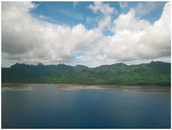
Figure 1.
Aerial shot of Kosrae Island, showing steep interior mountains.
To assess plants at risk and conservation priorities, more information can provide us with accurate and robust recommendations. However, for some plant species, only information such as their locality (latitude, longitude, and elevation) might be available. Because topographical factors are tied to the ranges of plant populations [17] and are easier to obtain than soil data, aspects, and other environmental factors, we propose the use of a rapid assessment methodology that includes species elevational range. We evaluated each of the nineteen endemic species of Kosrae using the available herbarium data, literature, personal knowledge of the flora, and geographical information system (GIS) tools. We compare these evaluations of the conservation statuses with a new rapid assessment methodology that can be utilized with just herbarium locality data. Based on collection data, this methodology can rapidly identify species at risk and requiring the most attention so that conservation plans can be developed to locate, monitor, and protect these species. We do not believe this should replace the use of the EOO, area of occupancy (AOO), or IUCN Red listing, but we feel this methodology can be utilized throughout the Pacific and may be used to identify species at risk due to restricted habitat requirements quickly.
2. Materials and Methods
Herbarium collections from the Bishop Museum (BISH), the National Tropical Botanical Garden (PTBG), the New York Botanical Garden (NY), and the Smithsonian (US) [18] were examined, and locality information was extracted from specimens. Locality information from transects (W. Law unpubl. data) was also added for several species to increase the available data. When collection material was unavailable in herbarium collections, species descriptions were studied for information regarding their occurrence and locality.
The authors conducted intensive biological field surveys on the island of Kosrae from 2006 to 2016. Kosrae, located north of the equator at 5°21′ N longitude and 163° E latitude, is the easternmost island of Micronesia in the western Pacific Ocean. Kosrae′s steep mountainous central region has remained poorly understudied due to the difficulty of accessing these areas. The small, roughly triangular, and high volcanic island is about 10–15 km across with rugged mountains, deep valleys, and a total area of approximately 109 km2 with a maximum elevation of 629 m. The average rainfall on Kosrae has been estimated at 5000 mm per year at the lower elevations and 7500 mm in the mountainous interior [19]. This island′s most insufficiently studied areas are the low-elevation cloud forests found in this area, extending to ca. 450 m in elevation. These low-elevation cloud forest ecosystems are home to many of Kosrae′s rare endemic plant species, for which documentation of their abundance and location is still lacking.
The objectives were to (1) locate populations of rare endemic plant taxa, (2) assess population health, (3) evaluate threats, (4) locate previously unrecorded species, and (5) make recommendations for managing and monitoring these rare endemic plant species. Access to locations with rugged topography was challenging. Several overnight expeditions were carried out to explore the steep peaks. Walkthrough transect methods were carried out on the peaks and areas just below the peaks. Occasionally, ropes were used to ensure the safety of the exploration. Herbarium voucher collections were made to document common and rare plant taxa during the surveys. Collection notes for each plant were made with detailed information of their location, color, height, habitat, and co-occurring species. The data for herbarium specimens were entered into the PTBG and NY herbarium databases. The participants of the field surveys were asked to rank the conservation assessments of individual endemic species based on the field observations and herbarium collections into one of three categories: (1) low risk of extinction, (2) high risk of extinction, and (3) high risk of extinction due to a lack of data.
The locations of endemic species were obtained using latitude and longitude directly from the collection notes from the surveys, data from the Bishop Museum Herbarium, the National Tropical Botanical Garden, the Smithsonian Museum, the Global Biodiversity Information Facility (GBIF) (http://www.gbif.org/) (accessed on 20 June 2014), and the New York Botanical Garden’s Virtual Herbarium (https://www.gbif.org/dataset/d415c253-4d61-4459-9d25-4015b9084fb0, accessed on 20 June 2014), or georeferenced using locality information from the collections and Google Earth [20]. The locality data were imported from a Microsoft Excel datasheet into ArcGIS 10 [21], and specimens with geographic coordinates were projected using WGS1984 UTM Zone 57 projection and made into a new shapefile. A digital elevation model (DEM) layer for Kosrae was added to the map database, and a new additional shapefile was created in Arc-Catalog, selecting “coordinates will contain Z values” to enable ArcMap to calculate the elevation data for each species. After calculating the lowest elevation per species, Raster Calculator was used to create a new raster file containing the area of the island in which the species is believed to be able to inhabit based on the elevation data available for that species.
We termed this metric the Extent of Inhabitable Elevation of the Island Occurrence (EIEIO). Suppose species are restricted to a particular elevation due to a specific habitat (i.e., mangroves). In this case, an elevational range (i.e., 10 m to 70 m) could be included; however, this was not utilized for the endemic species analyzed in this paper. For all species in this study, it was assumed that the species had an EIEIO that could include the entire island area above the lowest known elevational occurrence. For those species with an EIEIO value of less than 5% of the island’s area, they were considered “At Risk”.
3. Results
3.1. Preliminary Evaluations
Of the 19 Kosrae endemic plant species studied, it was determined that one species, Pandanus amissus Huynh, is actually a synonym of Pandanus dubius Spreng., a species occurring in southeast Asia and the Pacific islands, and it should no longer be included in the list of endemics. Eight species, Agrostophyllum kusaiense Tuyama, Bulbophyllum fukuyamae Tuyama, B. kusaiense Tuyama, Elaphoglossum kusaiense H.Ito., Psychotria hosokawae Fosberg, Selaginella kusaiensis Hosokawa, Rhynchophreatia pacifica (Fukuy.) Fosberg & Sachet, and Robiquetia kusaiensis Fukuy. were not represented by any modern collections or known from any current population, and we consider these species to be at high risk of extinction due to the absence of data. For the remaining species, because they are single-island endemics, we consider them all to be at risk of extinction but ranked them as either at high or low risk of extinction (Table 1).

Table 1.
Endemic species of Kosrae and their preliminary evaluations and evaluation after Extent of Inhabitable Elevation of the Island Occurrence calculation.
3.2. EIEIO Evaluation
For the eight species not known from the modern collections or current populations, we were able to calculate the EIEIO for three of these species, of which two, Agrostophyllum kusaiense and Rhynchophreatia pacifica, qualify under the at-risk designation, while Selaginella kusaiensis appear to be not at risk based on the EIEIO of historical data. Due to our lack of elevational data for the remaining species, we were unable to calculate their EIEIO values. We still consider these species at risk due to the lack of data, as these species are of special concern until more information can be learned about them. The remaining species were evaluated using all the locality information that could be compiled. The EIEIO for each of the species can be found in Table 1.
3.3. Species Evaluated to Be at Risk
3.3.1. Orchids
With CITES restrictions and the Federated States of Micronesia not being a signatory, it is difficult to transport collections of orchids even for scientific purposes, which may have contributed to the low collection of orchid specimens. Most of the endemic orchid species appear to be rare and are not known in any current populations. Phreatia kusaiensis Tuyama, while only represented by a single collection, is likely only limited because of the lack of collections due to CITES restrictions and the difficulties that come with the shipping of these specimens. Agrostophyllum kusaiense is reported in two collections; the first, collected by Takamatsu in 1936 from Mt. Mutunte, is currently housed at Bishop Museum, and the second was collected from Mt. Bauche in 1939 by Hatusima and is at the University of Tokyo Herbarium (TI). Bulbophyllum fukuyamae and B. kusaiense are known only in their type collections. The former was collected from Mt. Mutunte from the trunk of a tree in 1941, while the latter was collected by Hatusima in 1938 from Mt. Bauche. Both specimens are housed at TI. Robiquetia kusaiensis is another endemic orchid species that is only known from its type collection, which was collected from the Utwe Municipality, is housed at the National Taiwan University Herbarium (NTU), and is not known in any present day population. Rhynchophreatia pacificia has been collected five times, but the most recent collection is from 1946, and the species has not been identified in any present-day populations.
3.3.2. Cyrtandra kusaimontana Hosok.
This species of Cyrtandra is known in several modern-day localities but in low individual numbers, and it is only found at high elevations (Figure 2). Due to its sparse distribution, we consider this species at high risk of extinction, which coincides with an "At Risk" EIEIO evaluation since it is believed to only inhabit less than 3% of the island (Figure 3a).
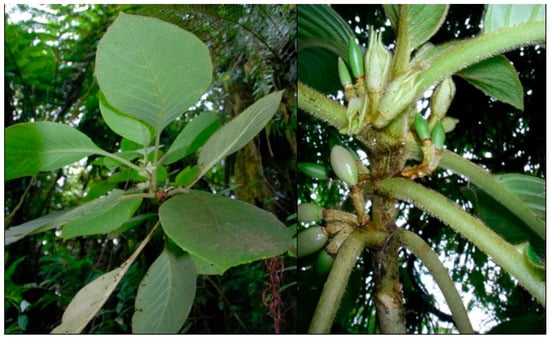
Figure 2.
Cyrtandra kusaimontana, with a close-up of the stem pubescence and inflorescences.
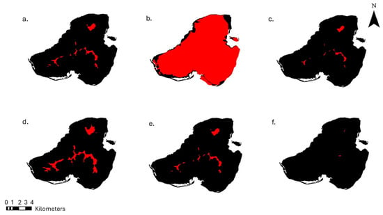
Figure 3.
The Extent of Inhabitable Elevation of the Island Occurrence indicated by the red areas (black areas indicate the areas of the island outside of the species range) of (a) Cyrtandra kusaimontana occupies less than 3% of the land area of Kosrae. (b) Elatostema fenkolense corresponds to more than 88% of the land area of Kosrae. (c) Medinilla diversifolia is only found above 460 m, and it only inhabits less than 2% of the land area of Kosrae. (d) Pandanus kusaicolous, a rare species, is found in just above the 5% threshold of the land area of Kosrae. (e) Peperomia kusaiensis occurs on less than 3% of the land area of Kosrae; it is fairly common in these areas, (f) Psychotria kosraensis is a newly discovered species, is extremely rare, and only occurs on less than 1% of the island of Kosrae.
Materials examined: Federated States of Micronesia (FSM), CAROLINE ISLANDS. Kosrae: Utwa Municipality, Finkol summit, 633 m elev., 11 September 2009, Wood et al. 13,944 (NY, PTBG); Lelu Municipality, peaks NE of Mutunte, 497 m elev., 18 March 2009, Wood et al. 13,621 (NY, PTBG); Malem Municipality, Mt. Oma, 410 m elev., 4 September 2009, Wood et al. 13,893 (NY, PTBG); Malem Municipality, Mt. Oma, 457 m elev., 18 March 2009, Perlman et al. 21,570 (NY, PTBG); Malem Municipality, Mt. Oma Summit, 2 December 1996, Flynn et al. 5995 (BISH, US, WU).
3.3.3. Elatostema fenkolense Hosok.
Our initial conservation assessment of this specimen evaluated this species at high risk of extinction because of the deficiency of data. The description of the type specimen of this collection was provided by Hosokawa in 1933 from the summit of “Mt. Fenkol” in an “Astronia thicket”, although a physical specimen was not examined for this study. Explorations of the summit have been unsuccessful in relocating this species in this location. There are a total of four different species of Elatostema reported from Kosrae. Elatostema kuasiensis is easily distinguished from the other three species, as it is ferruginous-hirsute, while E. fenkolense, E. calcarum, and E. urvilleanum are glabrous. While E. kusaiensis has been fairly well collected, the remaining three species are represented from Kosrae by their type material or species descriptions. After examination of the limited collection material and species descriptions of E. fenkolense, E. calcarum, and E. urvilleanum, the voucher collected by DH Lorence (9387) and previously identified as E. calcareum could be E. fenkolense. This voucher was collected from a coconut plantation at the south end of Walung Village. Using this location as the lowest known collection occurrence, we calculated the EIEIO for this species at 97.7211 km2 or 88.84% of the island area, and it is a species that should not be at risk (Figure 3b).
Materials examined: Federated States of Micronesia (FSM), CAROLINE ISLANDS. Kosrae: Utwe Municipality, Walung Village, south end, 2 m elev., 28 January 2005, Lorence et al. 9387 (NY, PTBG).
3.3.4. Medinilla diversifolia Kaneh.
The type specimen of this plant was collected by R. Kanehira from “Mt. Hinkoln” at 630 m. While it is difficult to match the name Mt. Hinkoln to any present location name, based on this elevation, it would most likely be Mount Finkol, as this is the highest point of Kosrae Island. Exploration of the peak of Mount Finkol did not lead to a relocation of Medinilla diversifolia. However, explorations of areas just below the peak revealed a population of M. diversifolia at 530 m.
Exploration of Mt. Oma in 2006 located one population of this plant along the highest ridge on the top of the mountain (Figure 4). As a climbing shrub, and due to its intertwining nature, it is difficult to distinguish if the clump found was more than one individual. It was located growing on a dead tree. When visiting this population in 2011, the tree had fallen over. It is unclear if this population will be able to persist on the ground.
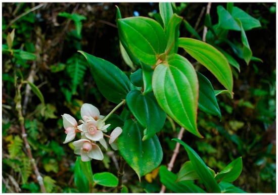
Figure 4.
Medinilla diversifolia.
Another population was identified below the peak of Mt. Mutunte. For this population, a clump, appearing to be at least two individuals, was found growing along the trail to the peak, and due to its location, it is at risk of being trampled. A second clump was found off the trail, climbing up a Sphaeropteris nigricans (Mett.) R. M. Tryon; this clump appears to be at minimal risk.
The lowest elevation this species was recorded at was 460 m. By using this elevation in ArcGIS, we calculated the EIEIO to be 1.6072 km2 which is only 1.46% of the island′s area. Therefore, we would consider this species to be at risk (Figure 3c).
Materials examined: Federated States of Micronesia (FSM), CAROLINE ISLANDS. Kosrae: Utwa Municipality, slopes just below Finkol, 530 m elev., 2 February 2010, Wood et al. 14,104 (NY, PTBG); Lelu Municipality, Mutunte, 580 m elev., 6 February 2010, Wood et al. 14,130 (NY, PTBG), loc. cit., 19 September 2011, Wood et al. 14,776 (NY, PTBG), Malem Municipality, Mt Oma, 460 m elev., 19 March 2009, Wood et al. 13,640 (NY, PTBG); loc. cit., 17 September 2011, Wood and Law 14,774 (NY, PTBG).
3.3.5. Pandanus kusaicolus Kaneh.
The endemic Pandanus is known from modern populations and occurs only close to the upper portions of the mountains. Given its large size, it is easy to identify and locate (Figure 5), although populations are fairly sparse. Although there are not many herbarium collections, this species occurs in several of the vegetation transects performed on the island. The authors rank this species at high risk of extinction; however, the EIEIO evaluation ranks this species as not at risk, as it just surpasses the 5% threshold of the island by less than 1% (Figure 3d).
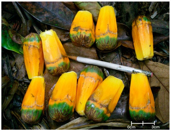
Figure 5.
The keys of the fruit of Pandanus kusaicolus.
Materials examined: Federated States of Micronesia (FSM), CAROLINE ISLANDS. Kosrae: Malem Municipality, 410 m elev., 4 September 2009, Wood, et al. 13,894 (NY, PTBG).
3.3.6. Pyschotria hosokawae Fosberg
This species is only known from the holotype housed at the Arnold Arboretum, which was collected in 1938 by T. Hosokawa. Attempts to relocate this plant, starting with identifying the collection area, “Ibrare, Kusaie”, have been unsuccessful. As described for this specimen by F.R. Fosberg in 1987, this rare, endemic plant is not known in any current populations. As we were unable to successfully locate from where this specimen was collected, we were unable to calculate the EIEIO, and consider this plant to be at risk due to data deficiency.
Materials examined: Federated States of Micronesia (FSM), CAROLINE ISLANDS. Kosrae: Ibrâre, 17 August 1938, T. Hosokawa 8775 (A).
3.3.7. Peperomia kusaiensis Hosok.
Known from several populations on the island (Figure 6), the authors feel that this species is at low risk of extinction. However, the EIEIO analysis ranked this species as one that should be considered at risk due to the area of the island in which it can occur—2.23% of the island (Figure 3e).
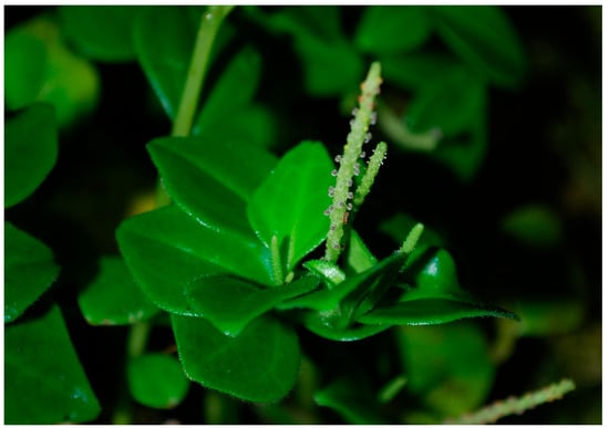
Figure 6.
Close-up picture of Peperomia kusaiensis.
Materials examined: Federated States of Micronesia (FSM), CAROLINE ISLANDS. Kosrae: Malem Municipality, Mt Oma, 410 m elev., 4 September 2009, Wood et al. 13,889 (NY, PTBG); Malem Municipality, Mt Oma, 440 m elev., 17 September 2009, Wood et al. 13,975 (NY, PTBG); Malem Municipality, Mt Oma, 440 m elev., 17 September 2009, Wood et al. 13,978 (NY, PTBG); Utwa Municipality, Mt. Finkol, 530 m elev., 2 February 2010, Wood et al. 14,106 (NY, PTBG).
3.3.8. Psychotria kosraensis Lorence & K.R. Wood
This species was previously undescribed. A small population of five individuals was located in one area below the steep peak of Mt. Mutunte and described by Lorence and Wood [22]. This species differs from other Psychotria spp. by its combination of narrowly elliptic leaves with a long acuminate apex, a peduncle less than 2 mm long, and fruit crowned with long calyx tube with dentate lobes [22] (Figure 7). The rest of the slope was intensively searched for other populations, but none were identified. Based on this population, the EIEIO of this species is 0.067% of the island, and it is considered at risk (Figure 3f).
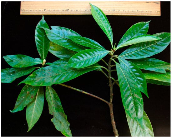
Figure 7.
Psychotria kosraensis, a recently described species.
Materials examined: Federated States of Micronesia (FSM), CAROLINE ISLANDS. Kosrae: Lelu Municipality, Finol (Mt.) Mutunte, NE slopes, 520 m, 6 February 2010, Wood and Law et al. 14,132 (holotype, PTBG-051672, PTBG-051673 [2 sheets]; Isotypes NY); loc. cit. 19 September 2011, Wood and Law et al. 14,778 (NY, PTBG).
3.3.9. Selaginella kusaiensis Hosok.
The type description of Selaginella kusaiensis reports specimens being collected from “Terminalia lowland forests in Utuwa (Utwe)” and from a “mossy Astonia forest at the summit of Mt. Bauche (Mt. Mutunte)”. The description states that it is closely related to S. kanehira Alston, and based on the text, the main differences between the two species are the overall size of the plant and its lateral leaves. S. kusaiensis is about 20 cm high, while S. kanehira grows to 35 cm; the leaves of S. kusaienses are 2–3 mm long and 0.8 mm wide with an acute apex, while those of S. kanehira are 2–5 mm long and 1.0 mm wide with a subacute apex. The majority of recent collections of Selaginella from Kosrae have been identified as S. kanehira. While most S. kusaiensis collections were collected pre-1950, there is a specimen collected by AF Rinehart in the 1990s. Based on the available historic data, this species has an EIEIO of 75.91 km2, can inhabit 69.18% of the island, and is not considered at risk. The absence of present-day collections, however, does raise red flags.
4. Discussion
Based on our observations, if we were to use the IUCN endangerment criteria [23], many of these species would fall into the Critically Endangered (CR) category, which designates these species as facing the highest risk of extinction. From our evaluations, several species appear to meet several points of the IUCN criteria, which include having an extent of occurrence of less than 100 km2, a severely fragmented distribution, a continuing decline in the number of mature individuals (as some species can no longer be found), an area of occupancy of less than 10 km2, a population size of fewer than 250 mature individuals, and no subpopulation containing more than 50 mature individuals. These are presented in Table 1.
However, to properly evaluate species using the IUCN criteria, many data need to be gathered for all of the indicated species. Our evaluation shows how we may be able to expedite part of this process by quickly identifying which species are at the greatest risk of extinction by using just the data that already exist from herbarium or previous collections. As our results show, our observations of extinction risk for these plant species are largely consistent with the rapid assessment methodology, which is only based on elevational data for the species when available. This does not mean that the IUCN assessment methodology is not needed; in fact, by utilizing EIEIO, we can direct our attention rapidly to the species that need the greatest attention and require effort to collect the data needed to properly identify Red List species.
Exceptions do occur. For example, Selaginella kusaiensis and Elatostema fenkolense, which we were able to calculate an EIEIO for, need further investigation. It is unclear if the pattern of Selaginella collection is based on a lack of representation in populations or if they are truly different species. The species delimitations and species concepts of these two species are poorly understood and require further study [16]. Additionally, Elatostema fenkolense is only known from two specimens despite potentially being distributed throughout the island; increased efforts to voucher these species are necessary to understand the species relationships, locations of the species, and size of the population. The historical data give us an incomplete picture of the species’ occurrence and range. Without further collections of these plants, understanding these species and accurate evaluation of their risk are not possible.
As for the other rare species, including Agrostophyllum kusaiense, Bulbophyllum fukuyamae, Bulbophyllum kusaiensis, Psychotria hosokawae, and Rhynchophreatia pacifica, more information is needed for these plants, as it currently appears that they may be extinct.
While elevational range is but one of the determining factors of the niche of a species, it is easier to collect than some of the other microclimate factors, like soil type, rainfall, and aspect. Utilizing this methodology can supplement other rapid assessment methodologies that are being developed for larger-scale areas [24], and it provides an additional type of opportunistic data that can be used for determining species that should ultimately be evaluated for threat by the IUCN [25]. Having more tools available to assess plants at risk will be important if we are to assist in Red List assessments, and we need to provide methods that will support the IUCN assessors with easy-to-use, appropriate techniques to prioritize assessments [26].
5. Conclusions
In Kosrae, a continued effort is needed to protect the upland forest. More research and exploration is required to locate the rare endemic species of this island and in other parts of the Pacific. The rapid assessment methodology utilized here can assist in quickly identifying which species are at risk by quickly understanding how much land area species can occur in based on elevational restrictions. This method is not meant to supplant the IUCN evaluation process but bring to attention the species that are most in need of assessment, so that management plans and conservation efforts can be designed around them. This methodology can also be broadly applied to other species evaluations in other locations with small land areas. It allows for studying the extent of occurrence and area of occupancy by narrowing down the specific area in which a species is able to occur and factoring in the elevational range in which it can occur.
Author Contributions
Conceptualization, W.L. and M.C.; methodology, W.L. and M.C.; software, M.C.; validation, W.L., K.R.W. and D.H.L.; investigation, W.L., K.R.W., D.H.L., J.S. and C.C.; data curation, W.L.; writing—original draft preparation, W.L.; writing—review and editing, W.L., K.R.W. and D.H.L.; funding acquisition, W.L. All authors have read and agreed to the published version of the manuscript.
Funding
This research was funded by the National Science Foundation, grant #0743375, and the National Geographic Foundation, grant #8519-08. The GIS work and lab was supported by the Prospect Hill Foundation. The preparation of the manuscript was supported by the Lynn University Writing Fellows Grant.
Institutional Review Board Statement
Not applicable.
Informed Consent Statement
Not applicable.
Data Availability Statement
The specimen data of the species can be found from the herbarium mentioned in the manuscript. The localities of the transect data remain unpublished but can be requested if needed to continue the conservation work.
Acknowledgments
We would like to thank Andy George of the Kosrae Conservation and Safety Organization and Robert Jackson and Erick Waguk of the Kosrae Island Resource Management Authority for their help in the fieldwork for this project.
Conflicts of Interest
The authors declare no conflicts of interest. The funders had no role in the design of the study; in the collection, analyses, or interpretation of data; in the writing of the manuscript; or in the decision to publish the results.
References
- Nic Lughadha, E. Towards a working list of all known plant species. Philos. Trans. R. Soc. B 2004, 359, 681–687. [Google Scholar] [CrossRef] [PubMed]
- Brummitt, N.; Bachman, S.P.; Moat, J. Applications of the IUCN Red List: Towards a global barometer for plant diversity. Endanger. Species Res. 2008, 6, 127–135. [Google Scholar] [CrossRef]
- IUCN. The IUCN Red List of Threatened Species 2009 Update: Plant Facts; IUCN: Gland, Switzerland, 2009; Available online: https://www.iucnredlist.org/ (accessed on 1 September 2010).
- IUCN. In The IUCN Red List of Threatened Species; Version 2002; IUCN: Gland, Switzerland, 2023.
- Couch, C.; Cheek, M.; Haba, P.; Molmou, D.; Williams, J.; Magassouba, S.; Doumbouya, S.; Yaya Diallo, M. Threatened Habitats and Tropical Important Plant Areas (TIPAs) of Guinea, West Africa; Royal Botanic Gardens: Kew, UK, 2019. [Google Scholar]
- Nic Lughadha, E.; Baillie, J.; Barthlott, W.; Brummitt, N.A.; Cheek, M.R.; Farjon, A.; Govaerts, R.; Hardwick, K.A.; Hilton-Taylor, C.; Meagher, T.R.; et al. Measuring the fate of plant diversity: Towards a foundation for future monitoring and opportunities for urgent action. Philos. Trans. R. Soc. B Biol. Sci. 2005, 360, 359–372. [Google Scholar] [CrossRef] [PubMed][Green Version]
- Nic Lughadha, E.; Bachman, S.P.; Leão, T.C.C.; Forest, F.; Halley, J.M.; Moat, J.; Acedo, C.; Bacon, K.L.; Brewer, R.F.A.; Gâteblé, G.; et al. Extinction risk and threats to plants and fungi. Plants People Planet 2020, 2, 389–408. [Google Scholar] [CrossRef]
- Willis, F.; Moat, J.; Paton, A. Defining a role for herbarium data in Red List assessments: A case study of Plectranthus from eastern and southern tropical Africa. Biodivers. Conserv. 2003, 12, 1537–1552. [Google Scholar] [CrossRef]
- Miller, J.S.; Porter-Morgan, H.A.; Stevens, H.; Boom, B.; Krupnick, G.A.; Acevedo-Rodríguez, P.; Fleming, J.; Gensler, M. Addressing target two of the Global Strategy for Plant Conservation by rapidly identifying plants at risk. Biodivers. Conserv. 2012, 21, 1877–1887. [Google Scholar] [CrossRef]
- GSPC. Global Strategy for Plant Conservation; The Secretariat of the Convention on Biological Diversity: Montreal, QC, Canada, 2002. [Google Scholar]
- Gaston, K.J.; Fuller, R.A. The sizes of species’ geographic ranges. J. Appl. Ecol. 2009, 46, 1–9. [Google Scholar] [CrossRef]
- The Nature Conservancy. A Blueprint for Conserving the Biodiversity of the Federated States of Micronesia; Micronesia Program Office: Kolonia, Micronesia, 2003. [Google Scholar]
- Myers, N.; Mittermeier, R.A.; Mittermeier, C.G.; da Fonseca, G.A.; Kent, J. Biodiversity hotspots for conservation priorities. Nature 2000, 403, 853–858. [Google Scholar] [CrossRef] [PubMed]
- Pouteau, R.; Giambelluca, T.W.; Ah-Peng, C.; Meyer, J.Y. Will climate change shift the lower ecotone of tropical montane cloud forests upwards on islands? J. Biogeogr. 2018, 45, 1326–1333. [Google Scholar] [CrossRef]
- Luetke, F.P. 1853. Voyage Autour de Monde sur la Corvette Dans les Annees 1826–1829; De L’Imprimerie de Crapelet: Paris, France, 1853; pp. 132–144, 337–352. [Google Scholar]
- Costion, C.M.; Lorence, D.H. The Endemic Plants of Micronesia: A Geographical Checklist and Commentary. Micronesica 2012, 43, 51–100. [Google Scholar]
- Slaton, M.R. The roles of disturbance, topography and climate in determining the leading and rear edges of population range limits. J. Biogeogr. 2015, 42, 255–266. [Google Scholar] [CrossRef]
- Thiers, B. Index Herbariorum. 2023. Available online: https://Sweetgum.Nybg.Org/Science/Ih/ (accessed on 15 June 2023).
- Laird, W.E. Soil Survey of Island of Kosrae, Federated States of Micronesia; United States Department of Agriculture: Washington, DC, USA, 1983. [Google Scholar]
- Google Inc. Google Earth, Version 7.1.5.1557; Google Inc.: Mountain View, CA, USA, 2013. [Google Scholar]
- ESRI. ArcGIS Desktop: Release 10; Environmental Systems Research Institute: Redlands, CA, USA, 2011. [Google Scholar]
- Lorence, D.H.; Wood, K.R. Psychotria kosraensis (Rubiaceae), a new species from Kosrae, Caroline Islands, Micronesia. Novon A J. Bot. Nomencl. 2012, 22, 51–55. [Google Scholar] [CrossRef]
- IUCN Standards and Petitions Committee. Guidelines for Using the IUCN RedList Categores and Criteria; IUCN: Gland, Switzerland, 2022. [Google Scholar]
- Pelletier, T.A.; Carstens, B.C.; Tank, D.C.; Sullivan, J.; Espíndola, A. Predicting plant conservation priorities on a global scale. Proc. Natl. Acad. Sci. USA 2018, 115, 13027–13032. [Google Scholar] [CrossRef] [PubMed]
- Maes, D.; Isaac, N.J.B.; Harrower, C.A.; Collen, B.; van Strien, A.J.; Roy, D.B. The use of opportunistic data for IUCN Red List assessments. Biol. J. Linn. Soc. 2015, 115, 690–706. [Google Scholar] [CrossRef]
- Cazalis, V.; di Marco, M.; Butchart, S.H.M.; Akçakaya, H.R.; González-Suárez, M.; Meyer, C.; Clausnitzer, V.; Böhm, M.; Zizka, A.; Cardoso, P.; et al. Bridging the research-implementation gap in IUCN Red List assessments. Trends Ecol. Evol. 2022, 37, 359–370. [Google Scholar] [CrossRef] [PubMed]
Disclaimer/Publisher’s Note: The statements, opinions and data contained in all publications are solely those of the individual author(s) and contributor(s) and not of MDPI and/or the editor(s). MDPI and/or the editor(s) disclaim responsibility for any injury to people or property resulting from any ideas, methods, instructions or products referred to in the content. |
© 2024 by the authors. Licensee MDPI, Basel, Switzerland. This article is an open access article distributed under the terms and conditions of the Creative Commons Attribution (CC BY) license (https://creativecommons.org/licenses/by/4.0/).