Article

Plant Diversity and Composition Changes along an Altitudinal Gradient in the Isolated Volcano Sumaco in the Ecuadorian Amazon

1
Herbario ECUAMZ, Universidad Estatal Amazónica, Km 2 ½ vía Puyo Tena, Paso Lateral, 160-150 Puyo, Ecuador
2
Dpto. de Ciencias Biológicas, Universidad Técnica Particular de Loja, San Cayetano Alto s/n, 110-104 Loja, Ecuador
3
Dpto. de Ingeniería Civil y Ambiental, Universidad de los Andes, Cra. 1E No. 19a-40, 111711 Bogotá, Colombia
4
IBED, Paleoecology & Landscape ecology, University of Amsterdam, Science Park 904, 1098 HX Amsterdam, The Netherlands
5
Universidad de las Fuerzas Armadas ESPE, Av. General Rumiñahui s/n, P.O.Box, 171-5-231B Sangolquí, Ecuador
*
Author to whom correspondence should be addressed.
Diversity 2020, 12(6), 229; https://doi.org/10.3390/d12060229
Submission received: 29 April 2020 / Revised: 27 May 2020 / Accepted: 29 May 2020 / Published: 8 June 2020

Abstract

:
The paramo is a unique and severely threatened ecosystem scattered in the high northern Andes of South America. However, several further, extra-Andean paramos exist, of which a particular case is situated on the active volcano Sumaco, in the northwestern Amazon Basin of Ecuador. We have set an elevational gradient of 600 m (3200–3800 m a.s.l.) and sampled a total of 21 vegetation plots, using the phytosociological method. All vascular plants encountered were typified by their taxonomy, life form and phytogeographic origin. In order to determine if plots may be ensembled into vegetation units and understand what the main environmental factors shaping this pattern are, a non-metric multidimensional scaling (NMDS) analysis was performed. In addition, species turnover was quantified in order to appreciate the quantity and sort of species which are responsible for the similarity or dissimilarity between vegetation units. Therefore, a SIMPER similarity percentage analysis was conducted. We encountered 68 plant species belonging to 54 genera and 31 families, of which three are Ecuadorian endemics. The most frequent life forms were erect herbs, rosette and tussocks, whereas the least were cushions. At genus level, 44% of the Sumaco paramo flora was of tropical origin, followed by temperate (33%) and finally cosmopolitan (22%). The neotropical montane element was the most represented with 15 species, followed by the Austral-Antarctic with ten, wide temperate with another ten and cosmopolitan with seven. Regarding vegetation, four floristically distinct groups were segregated being lower gradient (3250–3500 m a.s.l.) and high altitude (3500–3800 m a.s.l.)

1. Introduction

The paramo includes all natural and semi-natural ecosystems located above the natural montane tree line in the northern Andes [1,2,3]. Nevertheless, few isolated paramos exist, apart from the main cordilleras and are called extra-Andean paramos. The most adequate examples are located in Ecuador and cover the mountain tops of the Sumaco and Sangay volcanoes in the Amazon basin [4], as well as the Kutuku and El Condor Cordillera [5,6]. To date, only basic research has been conducted on these isolated paramos, even though they constitute a priority candidate for ecological and conservation efforts [7,8]. Generally, the largest distribution of the paramo is in the tropical mountains of Central and South America. Nonetheless, it is also present in certain areas within East Africa, Hawaii and Malaysia [9,10]. Chronologically, the paramo is constituted by tropical, temperate and cosmopolitan elements [11]. In addition, the evolutionary history of the paramo demonstrates that the origins of the present flora depend dominantly on elements from the northern continent more than own elements and southern hemisphere [12].
The Andean paramo is distributed in the high mountains of Venezuela, Colombia, Ecuador and northern Peru, where its flora contributes an important percentage of the regional biodiversity [13,14,15,16]. Currently, it is considered that the paramo is a strategic ecosystem in terms of environmental and landscape services, of which the most important are water production and regulation, as well as carbon storage [17,18]. In Ecuador, the paramo covers approximately five percent of the national territory and hosts about 1500 vascular plant species [19], with an endemism rate estimated of about 60% at species level [1]. It is considered as a fragile ecosystem, where the main threats are mainly fire, grazing, and Andean crops, among other minor causes [20,21,22,23].
Several studies have considered the ecosystem and its flora, trying to fit it into a regular classification system [24,25,26,27,28,29,30]. Its crossed flora and ecotones indicate a variety of local floristic features leading the classification of the vegetation of the paramo to advance significantly, particularly in Ecuador [1,31,32,33,34]. The denominations by their physiognomy (shrub, herbaceous), by type of climate (wet, dry) and/or plant associations [35], resulted in several types of paramo, such as the sub-paramo, where dense and shrubby vegetation dominates [36,37]. The mid paramo is considered a transition zone between the tree line and the open paramo, being of moist dense shrubland and glasslands vegetation [1,38]. The super paramo is characterized by sparse and discontinuous vegetation, with predominantly lichens, mosses and small herbs and shrubs, often belonging to the Asteraceae family, such as Senecio or Culcitium [39,40].
There is a severe lack of knowledge about the phytogeography on the extra-Andean paramo. Studies of the paramo of Costa Rica to Peru, where twelve genera have been described, originated from the Savannas [41]. In the study of the flora of Avila (Eastern Cordillera of Colombia), some 18 genera (15%) have been encountered [42], which originated from the Savannah [43]. Other studies of the phytogeography of the flora of the Podocarpus National Park in southern Ecuador indicated that very humid climate and regional isolation are considered as key factors in the current geographic distribution of the 187 genera of the paramo [44]. There are 40 genera in common with the puna (21%), and three other types of floristic geographical components, such as tropical (55%), temperate (38%) and cosmopolitan (7%).
In Ecuador, isolated paramos outside the eastern to western ranges of the Andes are physiognomically different from the paramos encountered on the ridges of both mountain ranges, which have been developed upon volcanic ash deposits and lava flows. Unfortunately, there are so far no studies in the isolated paramos of the Sumaco and Sangay volcanoes, most probably due to particular adverse weather conditions and accessibility [45], except for a single exploratory expedition which took place in 1979 [27]. Nonetheless, a recent study on Sumaco paramos has revealed new species records, and clarified the endemism as well as the plant communities [4].
The current study represents pioneering research on the ecology of extra Andean paramos, focusing on the Sumanco volcano. Hereby, we most likely count a lack of anthropogenic intervention, possibly presenting its own floristic evolution and with different types of paramo. There are so far no floristic records of the native taxa of these sites, leading undoubtedly to the first register of the flora and the ecologically identification of existing plant formations in the altitudinal gradient of the Sumaco volcano. Therefore, the main goal of our study has been to fully characterize the given flora (taxonomical diversity), vegetation (life forms) and the chorological aspects of the paramo belt on the Sumaco volcano.

2. Materials and Methods

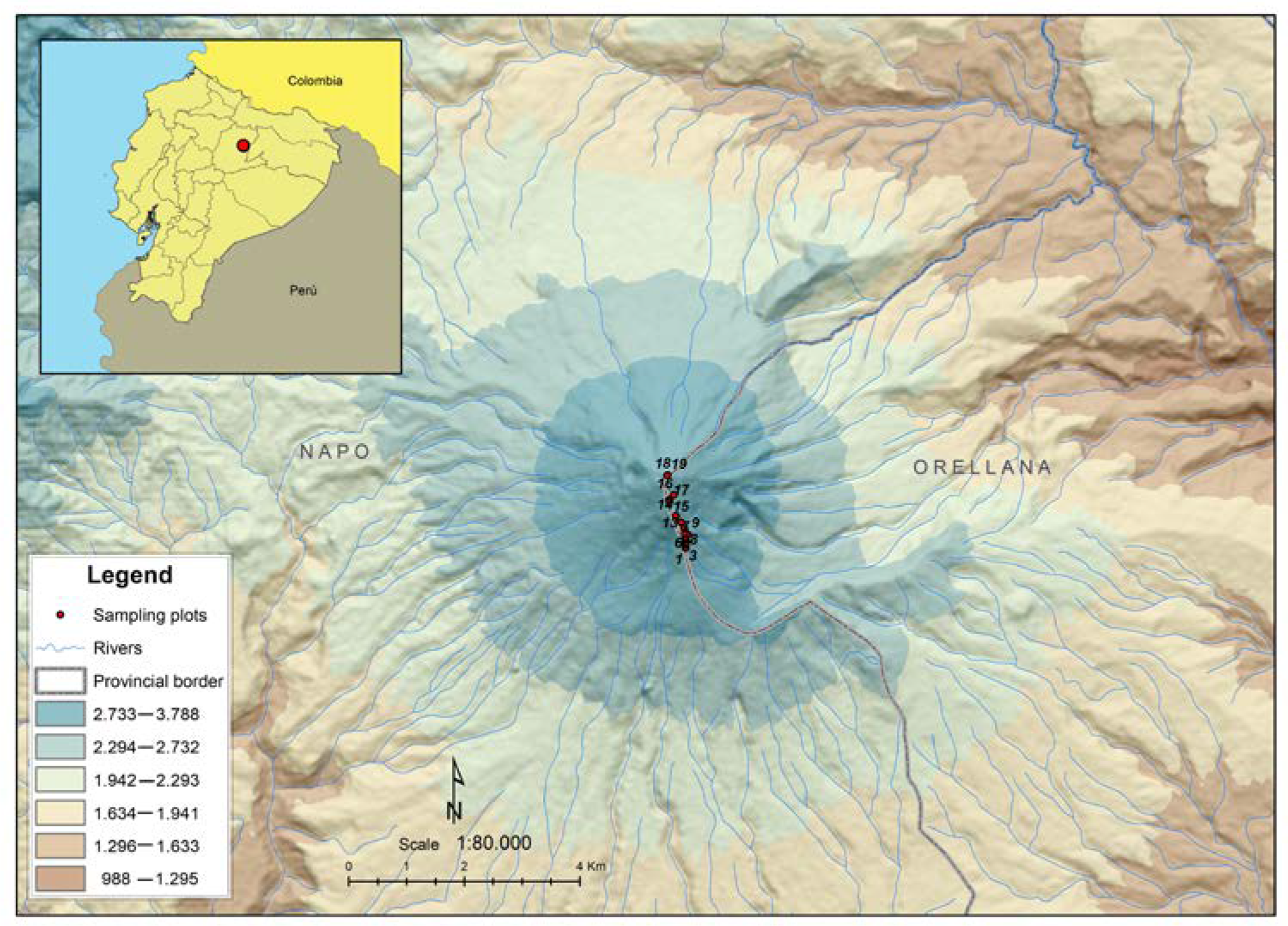
2.1. Study Area and Geological History of the Sumaco Volcano

The study was conducted within the Sumaco Napo—Galeras National Park (PNSNG), in the core area of the Sumaco Biosphere Reserve, which is located in the northeastern area of the Ecuadorian Amazon, between the provinces of Napo, Francisco de Orellana and Sucumbíos (Figure 1). The Sumaco volcano culminates at 3800 m above sea level (m a.s.l.), which is part of the sub-Andean volcanic cordillera and has been discovered and first described just a century ago [46,47,48,49]. It is located at approximately 105 km southeast of the city of Quito and 35 km northwest of Loreto, which is the nearest village in the Orellana province.
The active volcano and its magmatic products perforated pre-existing geological formations, such as the formations of Misahuallí, Hollín, Napo, Tena and Tiyuyocu, as well as granitic rocks of the Guacamayos [47,48]. The Sumaco Volcano was formed in two phases, of which the oldest phase, the Paleo-Sumaco (Ia and Ib, for its volcanic products) reached an approximate height of 3750 m a.s.l. After a violent eruption (Volcanic Explosivity Index = 6), it collapsed, and its height was reduced by almost half [49]. Later, a parasitic cone called Guagua Sumaco took place on the eastern slope of the volcano. The collapse itself produced an avalanche of debris that was deposited on the eastern side of the volcano. The event left a remarkable mark at a height of 2400 m a.s.l., while the ejected material covered a radius of at least 120 km2 around the volcano. The debris avalanche mainly filled the Suno River valley up to 500 m a.s.l., and partially the Rio Molino valley, which caused the damming of the waters in the two upper watersheds. The ash ejected during the eruption covered the surroundings of the volcano with a layer thickness of up to 10 to 20 m from the center of the emission and this allowed one to conclude that during the evolutionary process of the Sumaco volcano, explosive episodes of great magnitude took place. One of these was probably the cause of the collapse of the Paleo-Sumaco cone and the sliding of the north-eastern flank. After that, a landslide was generated in the north-eastern section of the volcanic building (Paleo-Sumaco) sequence of the collapse of a part of the cone [49].
The second phase (the current volcano, IIa and IIb) grew on the remains of the Paleo-Sumaco and reached a height of about 3732 m a.s.l. The Sumaco volcano is currently characterized by two craters. The oldest on the south flank appears with a strong erosion of the eastern side and the second is located in the north, of which the morphological characteristics are well preserved. The lava of this volcano is alkaline in nature, being the only ones in the Andes with this composition [46,50,51,52,53]. Its stages of volcanic reactivation should be related to the high tectonic activity present in this area [54,55]. Although historical eruptions have not been recorded, it is estimated that the most recent eruptions occurred between 1865 and 1925. Therefore, the volcano represents a potential hazard to the inhabitants of Loreto and Ávila Vieja, as well as to the transecuadorian pipeline system (SOTE) and for the oleoduct of heavy oils (OCP), although these will most likely be affected by the massive fall of ash [56].

2.2. Data Sampling and Processing

The sampling sites were located on the isolated paramo (00°32’28.7’’ S to 77°37’37” W), in the upper cone area, above the 3200 m a.s.l. elevation line up to 3800 m a.s.l. at the edge of the main cone. A total of 21 temporary plots of 5 × 5 m in four altitudinal classes were installed and sampled according to the phytosociological Braun Blanquet method [57,58] (3380 m a.s.l. n =6; 3500 m a.s.l. n = 6; 3700 m a.s.l. n = 3; 3800 m a.s.l. n = 6), which is considered adequate for low-height vegetation as found in the paramo, and has been extensively used in the paramo ecosystem [59,60], and specifically in Ecuador, e.g., [1,33,38,61]. In each plot, all vascular species present were listed and those that were not identified on the field were collected and coded. Abundance scores were established according to the Braun Blanquet scale (1, <5%; 2, 6–25%; 3, 26–50%; 4, 51–75%; 5, >75%); the symbols—‘r’ and ‘+’ were not used, due to the small size [9]. Then each species was classified according to its lifeform as: cushion, erect shrub, erect herb, prostrate herb, tussocks, acaulescent rosette, basal rosette or stem rosette [62,63,64]. The frequency of each of the life-forms described above was evaluated.
Other data acquired for each plot were the total cover of each vegetation stratum, geographic position, elevation, slope of the terrain, aspect and environmental temperature. These data were obtained with a frequency of four times every three months, within a one-year period. For all vascular plant species, 3–4 specimens were collected (Table S1), codified and stored in ziplocs for their ulterior transportation to the ECUAMZ herbarium, where they were then processed and added to the collection [65,66]. The taxonomic identification of each specimen was performed, based on the key treatments Flora of Ecuador [67] in the herbariums of the Universidad Estatal Amazónica (ECUAMZ), the Ecuadorian Museum of Sciences (QCNE) and the herbarium of the Pontificia Universidad Católica de Quito (QCA)

2.3. Statistical Analyses of Plant Diversity and Species Assemblages

In order to reflect plant diversity at plot level, the Shannon diversity index (SDI) was calculated [68,69]. This index offers insight on the effect on each species, in relation to the number of individuals. The equation indicated below was applied using the PAST software [70].
H = i = 1 S p i   l n p i
H′ is the Shannon index, p is the proportion (n/N) of individuals of one particular species found (n) divided by the total number of individuals found (N), ln is the natural log, Σ is the sum of the calculations, and S is the number of species.
In order to determine if the plots were grouped into vegetation units and understand what the main environmental factors are that form this pattern, a non-metric multidimensional scaling analysis (NMDS) was performed [71,72]. In order to assess the goodness of the NMD cluster, we used the stress values proposed by Clarke 1993 [73], as follows: 0.05 = excellent, = 0.10 good, 0.20 usable and > 0.20 not acceptable.
First, the Bray–Curtis dissimilarity distance was calculated [74,75], which is a statistic used to quantify the compositional dissimilarity between two different sites. The values of Bray–Curtis dissimilarity are bounded between 0 and 1, where 0 means the two sites have the same composition (that is they share all the species), and 1 means the two sites do not share any species, based on species counts at each site, and is calculated by applying the equation:
B C i j = 1 2 C i j S i + S j
where Cij is the sum of the lesser values for only those species in common between both sites. Si and Sj are the total number of specimens counted at both sites [76].
In order to build a dissimilarity matrix between plots, and later the final results, they were plotted in a NMDS ordination diagram using the ‘vegan’ package in R.3.4.4 [77]. Values of relative species abundance and environmental variables were then fitted onto the first two axes of the NMDS ordination, squared correlation coefficients (r2) and empirical p-values (p), which were calculated for these linear fittings. The averages at plot level and group level of Shannon diversity index SDI and others characters were compared using a Kruskall–Wallis test between each group assimilable to a vegetation unit.
The frequency of lifeforms was compared using a Chi-square test (χ2) contrasting the same groups or communities resulting of the previous ordination analysis. In addition, species turnover was quantified, in order to count and list the species responsible for the similarity or dissimilarity between vegetation units. Therefore, a SIMPER similarity percentage analysis was conducted [78,79] using the software PRIMER v6 [80]. This procedure, proposed by (Clarke, 1993), assesses the average percentage contribution of individual variables (species) to the dissimilarity between objects in a Bray–Curtis dissimilarity matrix. It allows one to identify variables that are likely to be the major contributors to any differences between groups.

2.4. Geographic Plant Distribution

The paramo vascular plant genera of the Sumaco volcano were grouped into geographic component and flora element following Cleef 1979 [81], Cleef and Chaverri 1992 [82,83] and Sklenář et al., 2011 [84]. This was based on three main components; (a) tropical, (b) temperate and (c) cosmopolitan, and the percentages of each geographic component and element were calculated.

3. Results

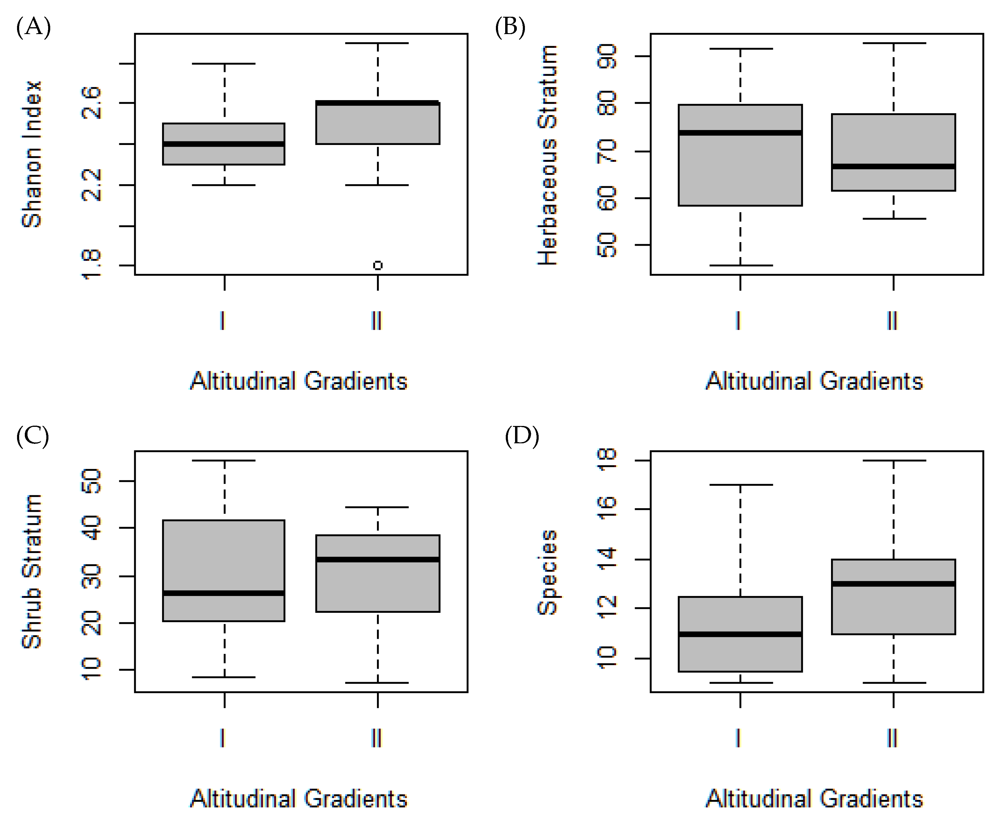
3.1. Plant Diversity

The paramo plant diversity on the Sumaco volcano is represented by 68 species of terrestrial vascular plants, belonging to 54 genera and 31 families. The vegetation covers between 95–100% of the substrate and the height of the main vegetation strata reach 0.5–2 m. The predominant life forms of the Sumaco Volcano plants are erect shrubs, erect herbs, tussocks, just a few cushions, and various types of rosettes characteristic of the paramos. The most diverse families were Asteraceae with eleven species (14.9% of the total determined species), Orchidaceae with seven species (10.4%), followed by Cyperaceae, Dryopteridaceae, Ericaceae, Lycopodiaceae and Poaceae with four species, each representing 6% of the total species. At genus level, the dominant ones were Elaphoglossum, Epidendrum and Huperzia with four species each, followed by Carex with three species, and Agrostis, Blechnum, Elleanthus, Grammitys, Miconia and Stellis with two species, whereas all other genera only presented one species. The SDI values (2.6 ± 0.1) did not show significant differences along the altitudinal gradients (χ2 = 0.87, p = 0.34), and neither did the other environmental variables.

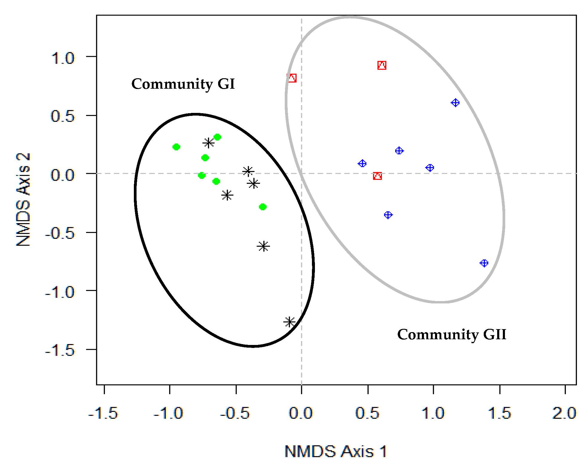
3.2. Species Assemblages and Floristic Groups along Gradient

Following the NMDS analysis, the plots were grouped within two preliminary “communities” or floristic groups (Figure 2), the first group (G I) including the plots of the lowest altitude classes, while the second group (G II) accounted for the plots located in the highest altitude classes. The stress values that the cluster reached when reducing the dimensionality of the model are acceptable (stress = 0.12). There are further factors other than the altitude, which is the most influential variable that determines the clustering of plots (Table 1, Figure 3). The growth habit also determines the affinity of the plots, being the greater presence of herbaceous species in the plots of the first two gradients that influence its grouping, while the greater number of shrub species in the plots located in the higher gradients, is the factor that determines the separation in the groups. Temperature is not relevant in the grouping.
In the community GII (3300–3504 m a.s.l.), 39 species and 31 genera were determined, Orchidaceae being the most diverse family, with nine species, followed by Asteraceae and Ericaceae with four species each, and Dryopteridaceae, Cyperaceae and Poaceae with two species each. This gradient develops at an intermediate altitude of the volcano and it presents a dense vegetation of herbaceous and shrubby type, with a range of plant cover of 100%. The height of the herbaceous layer is of about 0.15–2 m and the shrub layer is around 0.30–2.50 m. This strip is very well delimited. The arboreal stratum decreases its size, increasing the altitude and bushes scattered among the “pajonal” next to small grasses. The species with the highest percentage of coverage belonging to the dominant families throughout the sampled area were: Elleanthus aurantiacus (20%) for Orchidaceae; Elaphoglossum dendricolum (20%) for Dryopteridaceae; Cortaderia nitida (75%) for Poaceae; Pernettya prostrata (15%) and Disterigma codonanthum (15%) for Ericaceae; and Monticalia andicola (5%) for Asteraceae.
In the community GI (3585–3778 m a.s.l.), 42 species and 34 genera were determined. Asteraceae is the most diverse family with seven species, followed by Orchidaceae with five species, and Cyperaceae, and Poaceae with three species each. The species with the highest coverage are Monticalia andicola (25%), Diplostephium rupestre (25%), Pernettya prostrata (25%), Huperzia hystrix (5%) and Blechnum cordatum (5%). This community has been encountered in the upper cone, on a rounded crest, and it has low herbaceous, as well as shrubby vegetation of around 0.15–1 m in height. The “pajonal” is a variable where there are low, dry and humid “pajonales” grasslands. In most of the sites, they are covered by a great variety of mosses.

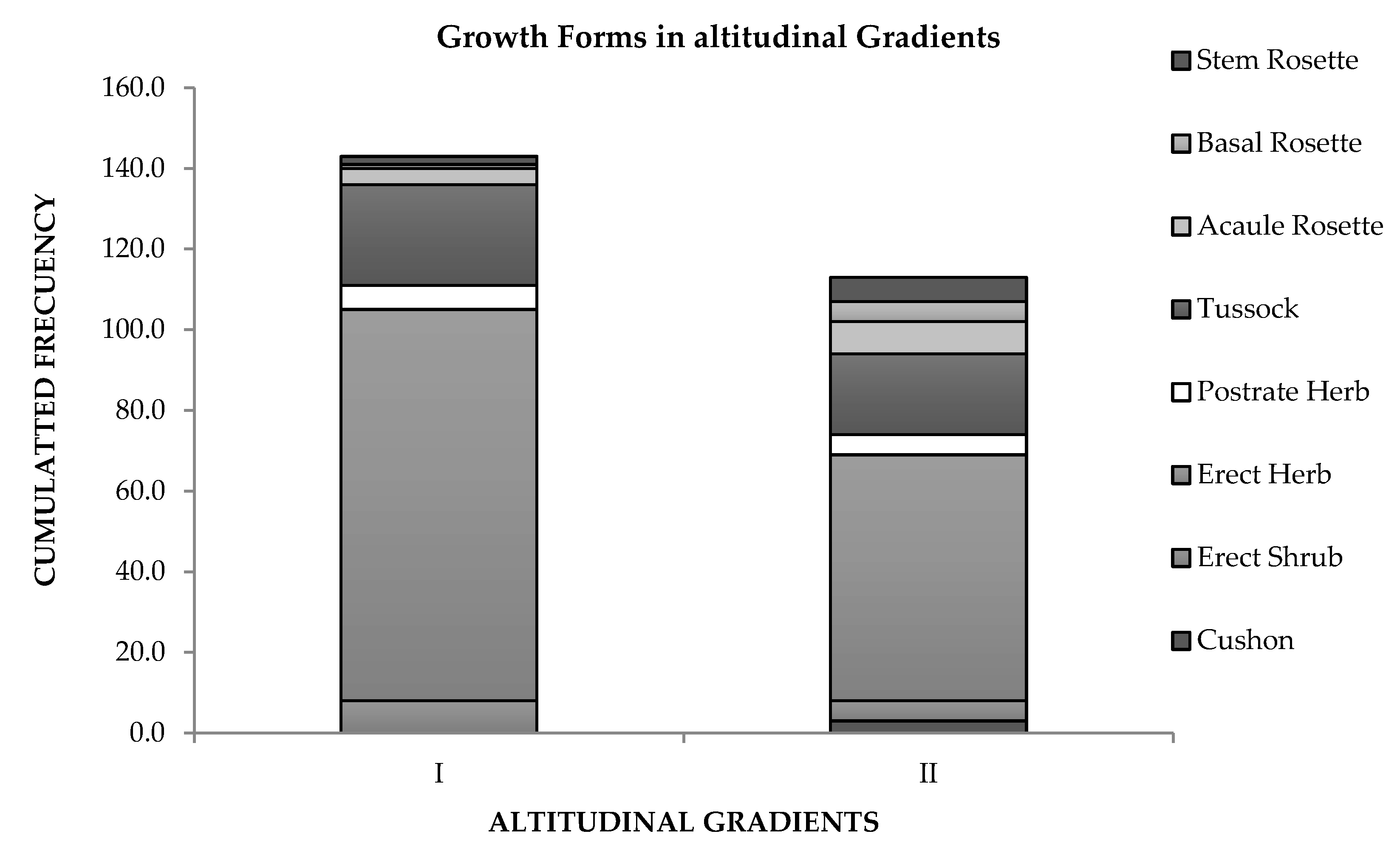
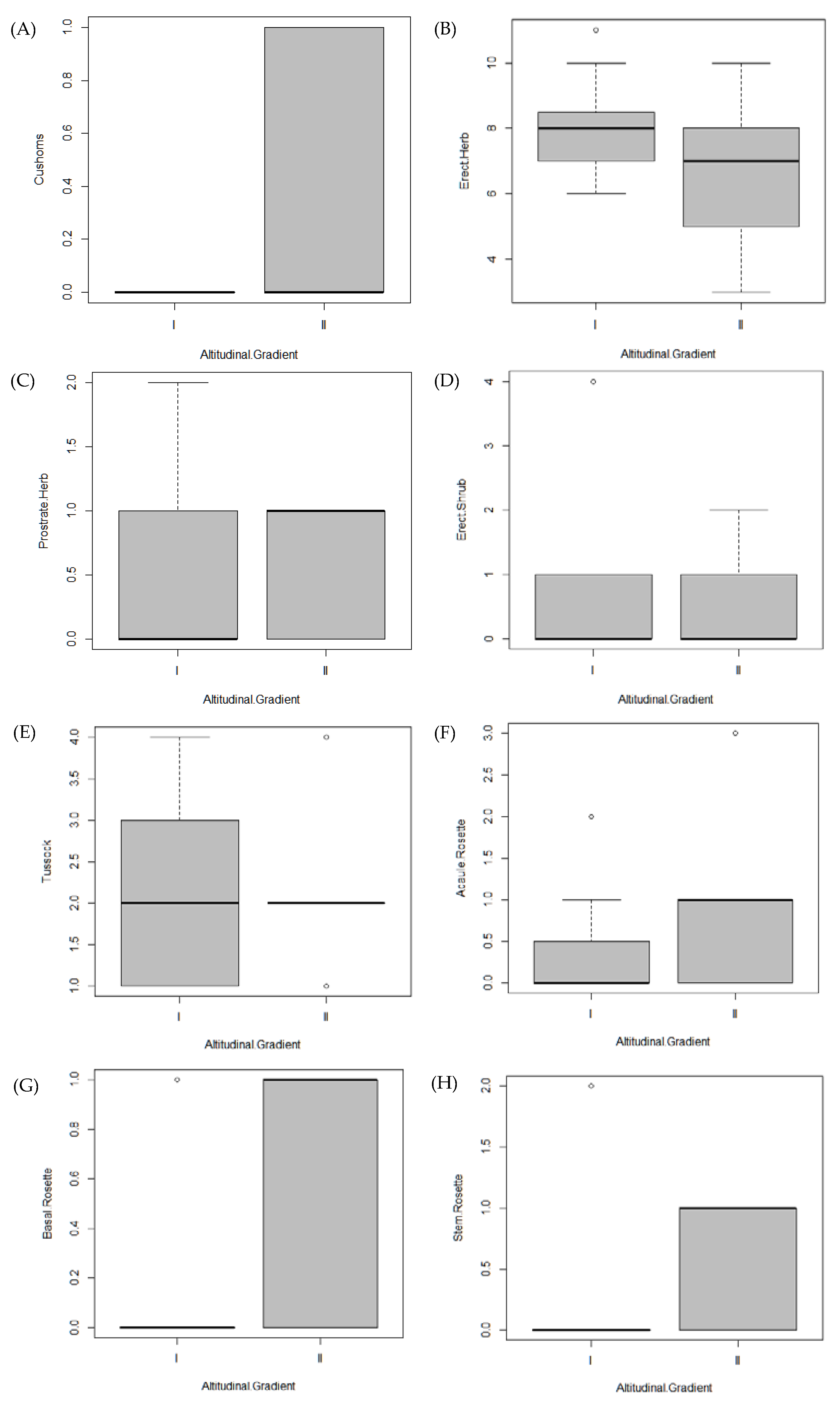
3.3. Life Forms and Species Turnover

In the communities of the two gradients, the dominant lifeforms of the species were the erect herbs (39 species of the 68 registered, 59%), the bunchgrass (10 species 14.5%) and the prostrate herbs (4 species 5.8%). There are so far no records of cushion plants at the first community. However, at the next community, just one species is present (1.4%). The “rosettes”, in general, are acaulescent, with six species (8.7%), two basal (2.8%) and four stem rosettes (5.8%) (Figure 4).
The lifeforms that indicate a significant difference in frequency between gradients are the cushions (Table 2, Figure 5), the basal rosettes, and the stem rosettes, which are more frequently in community II at higher altitudes. The rest of the lifeforms lack the presentation of significant differences throughout the two communities.
The turnover species among the gradients is the main reason why the plots are grouped. The gradients are floristically different. Distribution and abundance are characteristics that respond to its spatial distribution pattern, and to other factors that we have not been classified so far. The difference between gradients is evident and the SIMPER analysis indicates the calculated values for each of the gradients. The gradients III–IV are the most dissimilar (84.8%), while the least dissimilar are the gradients I–II (54.1%). The values of dissimilarity between the I–III gradients are also high (77.9%) and the dissimilarity values between the III–IV gradients (67.7%) confirm the floristic separation of the first two gradients in a floristic group and the other two gradients, forming another floristic group. Table 3 lists the five species responsible for the floristic dissimilarity in each gradient, as well as the average values of abundance of each of them in each gradient and a cumulative value of the percentage that represent each one of them.

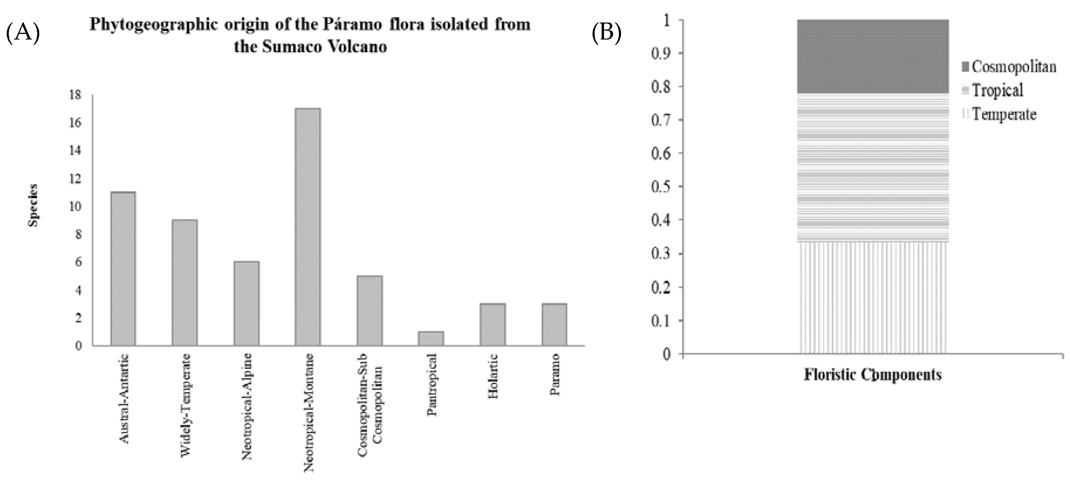
3.4. Plant Geography

Of the total 54 genera recorded, 44.5% belong to the tropical component, followed by temperate with 33.3%, and cosmopolitan with 22.2%. The neotropical montane element has the highest number of species with 15, followed by Austral-Antarctic with ten species. Similarly, with ten and seven species are wide temperate and cosmopolitan, respectively, and this declined to five and four species for the paramo-puna and paramo, respectively (Figure 6).
Correlating the migration on extra-Andean paramo, at the same latitude in the paramos of the cordillera real (Antisana Ecological Reserve, UTM code 17MRV24, VegParamo 2018), there are 13 species and 5 genera in common with the Sumaco Volcano, most of them being erect herbs. Although there is also a considerable amount of tussocks that occur in both paramos, Xenophyllum humile (Kunth) VA Funk, is the only rosette shared on both sites [85]. Further, west within the same Reserve Antisana (UTM code 17MRV14, VegParamo 2018), only four species and seven genera are present in both sites. Likewise, in the area of Aloag—Machachi (UTM code 17MQV64), we only found two species and one genus in common with the species recorded in the Sumaco volcano.

4. Discussion

4.1. Diversity and Main Life Form

The results reveal the importance of examining the biodiversity and ecology of isolated volcanos and their extra-Andean paramos in particular, as part of the recovery plant species growing mainly on ash and volcanic rock, where distribution models of plant species and communities obey to patterns are widely known [86,87,88,89], even with phytoclimatics patterns [90], where the plant distribution is clearly shown and now confirmed by the applied analysis and the given results. According to our study, the Sumaco vascular flora reaches 68 species of terrestrial vascular plants, a significantly higher amount than the previously reported 43 species and we observed several additional non-vascular species, including some lichens [27]. The most abundant species registered on the Sumaco are of Monticalia andicola (previously registered and referred to as Senecio andicola (Asteraceae), Disterigma codonanthum and Pernettya prostrata (Ericaceae), Cortaderia nitida (Poaceae), Huperzia hystrix (Lycopodiaceae), and Elaphoglossum dendricolum (Dryopteridaceae) [85,91,92]. Such species are common in other areas of the northern and central paramo of Ecuador, especially on active and dormant volcanoes. This counts as one of the types of vegetation of the Chimborazo and Chiles volcanoes in the Highlands, being an environment of desert paramo of cushions, where they stand out from the rest of the groups [93]. There, the vegetation is low, characterized by the presence of small erect shrubs and herbs, while rosettes are absent [5].
Other paramos, like in the Podocarpus National Park [94], are much more diverse than the paramo of the Sumaco volcano. There, in a single plot, there have been around 86 species registered. Nevertheless, it is necessary to demonstrate that the conditions, mainly of volcanism, are impediments, and therefore, its natural restoration phase reaches the later stages, leading to an idea of the flora which is potentially fully adapted to such conditions. This low diversity species, with a notable absence of endemic species, with only four registered species vs. some 39–40% in high elevation paramos, represented by ~508 species reported by Balslev 1988 [95], is low due to the fact that the paramos of the Sumaco volcano are in the center of the Amazon rainforest on a cone of the volcano, with a short time of colonization. In addition, due to the last eruption of Sumaco Volcano, which occurred some 150 years ago, most of the vegetation of the upper slopes was destroyed, therefore it is called a “young paramo” based on the given restoration time [27].
Another aspect that should be highlighted in the flora of Sumaco is that the bushes represent a low percentage of its composition with some nine species (13%). In other paramos of Ecuador that are included in the Eastern Cordillera, the shrub elements occupy entire strips, even being called strip of paramo (shrubland), which has a high amount of species [96]. However, the shrub species in the isolated volcanoes are adapted to much harder conditions, being both climatic and edaphic [26].

4.2. Phytogeography and Distribution Patterns

The presence of 54 genera is low compared with the 201 genera recorded at the Podocarpus massif, the 149 genera in the Sierra Nevada de Mérida, or the 150 genera in Guaramacal of Venezuela [44,97,98]. The presence of island-type ecosystem in middle of the Amazon basin forest is remarkable, producing a high percentage of neotropical montane element, due to the high precipitation range and easy wild dispersion. This probably occurs due to the lack of organic soil and the dominance of ash and volcanic rock, allowing the higher second presence of the Austral-Antarctic element, where most of the landscape is covered by Cortaderia tussocks. This may also be well influenced by the presence of the paramo-puna element, whereas the presence of cosmopolitan and wide temperate obeys an easy system of colonization by wind or bird distribution.
There is a broad description of the distribution patterns of the paramo species, of the isolated volcano areas, which is lacking [99]. By trying to compare the patterns of the Sumaco volcano with the paramos of the central mountain range, we may yield that the distribution of the Sumaco species obeys the same factors that distribute the species in the paramos of other volcanoes to the west of the mountain range (Antisana and Chimborazo volcanoes). Thereby, the vertical zonation, with its respective climatic characteristics and the relatively young vegetation cover, leads to the composition of the Sumaco volcano being similar to the rest of the volcanoes, although the absence of shrub elements is typical of lower vegetation formations and of higher paramos (super paramos), placing it within a unique composition of species.

5. Conclusions

On the Sumaco volcano isolated paramo, the vegetation is mountain-characteristic and as elevation increases, the vegetation physiognomy gradually changes from shrubby to grasslands and finally patchy to bare substrate where the most recent eruptions occured. Although the flora of the isolated Amazonian volcanoes has been poorly studied, apparently the influence of altitude exerts the same effect on the paramo of the mountain range, as well as the volcanoes. An altitudinal gradient in the mountain range central discriminates the super-paramo (at higher altitudes), with the lower ranges dominated by Poaceae and possibly with lower paramos (mid paramo), dominated by bushes (Ericaceae) and herbs (ferns and lycopodium). This is something that occurs in the Sumaco volcano, since the rosettes and cushion typical of the super-paramo are present in the highest gradient. The presence of these species determines the structure of the so-called super paramo. Plant diversity can also be influenced by altitude.
The isolated paramos of the Sumaco volcano are in a good state of conservation, with a range of pioneer plant cover of 95% to 100%. There are significant differences in the number of individuals, life forms and diversity, with respect to the altitudinal gradient. Marked differences were found within each strip, which is possibly a product of the presence of microhabitats caused by the interaction of the edaphic—environmental variables of the different altitudes in which they were sampled. The intact conservation of this ecosystem is due to the distance, rough terrain and difficult access to the summit.

Supplementary Materials

The following are available online at https://www.mdpi.com/1424-2818/12/6/229/s1, Table S1: Field data (excel supplement).

Author Contributions

Conceptualization, P.L.; Methodology, P.L., G.P., O.C.; Writing—original draft preparation, P.L., O.C., G.P., A.C., and T.T.; Writing—review and editing, P.L., O.C., G.P., A.C. and T.T. All authors have read and agreed to the published version of the manuscript.

Funding

This work was technically and financially supported by Universidad Estatal Amazónica and Universidad Técnica Particular de Loja.

Acknowledgments

To Mgs. Galo Guaman (UTPL) for helping in GIS analysis. We would also like to express our acknowledgements to the Ecuadorian environmental ministry in the Napo province.

Conflicts of Interest

The authors declare no conflict of interest.

References

  1. Luteyn, J.L.; Churchill, S.P.; Griffin, D.; Gradstein, S.R.; Sipman, H.J.; Mauricio, R. Gavilanes A. Paramos: A Checklist of Plant Diversity, Geographical Distribution, and Geo Botanical Literature; New York Botanical Garden Press: Bronx, NY, USA, 1999; Volume 84. [Google Scholar]
  2. García, V.J.; Márquez, C.O.; Isenhart, T.M.; Rodríguez, M.; Crespo, S.D.; Cifuentes, A.G. Evaluating the conservation state of the páramo ecosystem: An object-based image analysis and CART algorithm approach for central Ecuador. Heliyon 2019, 5, e02701. [Google Scholar] [CrossRef] [PubMed] [Green Version]
  3. Christmann, T.; Oliveras, I. Nature of Alpine Ecosystems in Tropical Mountains of South America; Elsevier: Amsterdam, The Netherlands, 2020. [Google Scholar]
  4. Lozano, P.; Cleef, A.M.; Yangora, J.; Torres, B.; Carrión, J.; Abril, R. Páramos Aislados del Volcán Sumaco, Amazonía del Ecuador; Universidad Estatal Amazónica: Puyo, Ecuador, 2013; p. 120. [Google Scholar]
  5. Guayasamin, J.M.; Bonaccorso, E. (Eds.) Evaluación Ecológica Rápida de la Biodiversidad de los Tepuyes de la Cuenca Alta del Río Nangaritza, Cordillera del Cóndor, Ecuador; Conservación Internacional: Quito, Ecuador, 2013; p. 135. [Google Scholar]
  6. Quizhpe, W.; Benítez, Á.; Cuenca, K.; Uvidia, H.; Huamantupa-Chuquimaco, I.; Muñoz, J.; Cabrera, O. Forest Diversity and Structure in the Amazonian Mountain Ranges of Southeastern Ecuador. Diversity 2019, 11, 196. [Google Scholar] [CrossRef] [Green Version]
  7. Hodge, A.-M.C.; Arbogast, B.S. Carnivore diversity at a montane rainforest site in Ecuador’s Gran Sumaco Biosphere Reserve. Oryx 2015, 50, 474–479. [Google Scholar] [CrossRef] [Green Version]
  8. Torres, B.; Vasco, C.; Günter, S.; Knoke, T. Determinants of Agricultural Diversification in a Hotspot Area: Evidence from Colonist and Indigenous Communities in the Sumaco Biosphere Reserve, Ecuadorian Amazon. Sustainability 2018, 10, 1432. [Google Scholar] [CrossRef] [Green Version]
  9. Ramsay, P.M.; Oxley, E.R.B. The growth form composition of plant communities in the ecuadorian páramos. Plant Ecol. 1997, 131, 173–192. [Google Scholar] [CrossRef]
  10. Sklenar, P. Advance of plant species on slopes of the Chimborazo volcano (Ecuador) calculated based on unreliable data. Proc. Natl. Acad. Sci. USA 2016, 113, E407–E408. [Google Scholar] [CrossRef] [PubMed] [Green Version]
  11. Vilhena, D.A.; Antonelli, A. A network approach for identifying and delimiting biogeographical regions. Nat. Commun. 2015, 6, 6848. [Google Scholar] [CrossRef] [PubMed]
  12. Sklenar, P.; Duskova, E.; Balslev, H. Tropical and Temperate: Evolutionary History of Páramo Flora. Bot. Rev. 2010, 77, 71–108. [Google Scholar] [CrossRef]
  13. Hofstede, R.; Segarra, P.; Mena Vásconez, P. (Eds.) Los Páramos del Mundo. Proyecto Atlas Mundial de los Páramos; Global Peatland Initiative: Quito, Ecuador, 2003; p. 299. [Google Scholar]
  14. Jiménez-Rivillas, C.; García, J.J.; Quijano-Abril, M.A.; Daza, J.M.; Morrone, J.J. A new biogeographical regionalization of the Paramo biogeographic province. Aust. Syst. Bot. 2018, 31, 296–310. [Google Scholar] [CrossRef]
  15. Cuesta, F.; Muriel, P.; Llambí, L.D.; Halloy, S.; Aguirre, N.; Beck, S.; Carilla, J.; Meneses, R.I.; Cuello, S.; Grau, A.; et al. Latitudinal and altitudinal patterns of plant community diversity on mountain summits across the tropical Andes. Ecography 2017, 40, 1381–1394. [Google Scholar] [CrossRef]
  16. Lozano, P. Plant Biodiversity of Ecuador: A Neotropical Megadiverse Country. In Global Biodiversity: Selected Countries in the Americas and Australia; Apple Academic Press: Waretown, NJ, USA, 2018; Volume 4, pp. 185–211. [Google Scholar]
  17. Harden, C.P.; Hartsig, J.; Farley, K.A.; Lee, J.; Bremer, L.L. Effects of Land-Use Change on Water in Andean Páramo Grassland Soils. Ann. Assoc. Am. Geogr. 2013, 103, 375–384. [Google Scholar] [CrossRef]
  18. Buytaert, W.; Tobón, C.; Cuesta-Camacho, F. Potential impacts of climate change on the environmental services of humid tropical alpine regions. Glob. Ecol. Biogeogr. 2010, 20, 19–33. [Google Scholar] [CrossRef]
  19. León-Yánez, S. La Flora de los Páramos Ecuatorianos. En: La Biodiversidad de los Páramos; Serie Páramo; GTP/AbyaYala: Quito, Ecuador, 2000; Volume 7, pp. 5–21. [Google Scholar]
  20. Vásquez, D.L.A.; Balslev, H.; Sklenar, P. Human impact on tropical-alpine plant diversity in the northern Andes. Biodivers. Conserv. 2015, 24, 2673–2683. [Google Scholar] [CrossRef]
  21. Webster, P.X.A.; Barros, S.; Siddons, D.C.; Zárate, E. Influence of habitat modification by livestock on páramo bird abundance in southern Andes of Ecuador. Stud. Neotrop. Fauna Environ. 2017, 53, 29–37. [Google Scholar]
  22. Espinosa, J.; Rivera, D. Variations in water resources availability at the Ecuadorian páramo due to land-use changes. Environ. Earth Sci. 2016, 75, 1173. [Google Scholar] [CrossRef]
  23. Borrelli, P.; Armenteras, D.; Panagos, P.; Modugno, S.; Schütt, B. The Implications of Fire Management in the Andean paramo: A Preliminary assessment using Satellite Remote Sensing. Remote Sens. 2015, 7, 11061–11082. [Google Scholar] [CrossRef] [Green Version]
  24. Acosta Solís, M. Divisiones Fitogeográficas y Formaciones Geobotánicas del Ecuador; Casa de la Cultura Ecuatoriana: Quito, Ecuador, 1968; No. 581.9866 A26. [Google Scholar]
  25. Harling, G. The Vegetation Types of Ecuador: A Brief Survey; Academic Press: London, UK, 1979. [Google Scholar]
  26. Cañadas, L. El Mapa Bioclimático del Ecuador; Ediciones del Banco Central del Ecuador: Quito, Ecuador, 1983. [Google Scholar]
  27. Løjtnant, B.; Molau, U. Analysis of virgin paramo plant community on Volcán Sumaco, Ecuador. Nord. J. Bot. 1982, 2, 567–574. [Google Scholar] [CrossRef]
  28. Sierra, R. Propuesta Preliminar de un Sistema de Clasificación de Vegetación Para el Ecuador Continental; Proyecto Inefan/Gef-Birf; EcoCiencia: Quito, Ecuador, 1999. [Google Scholar]
  29. Josse, C.; Cuesta, F.; Navarro, G.; Barrena, V.; Cabrera, E.; Chacón-Moreno, E.; Tovar, A. Ecosistemas de los Andes del Norte y Centro. Bolivia, Colombia, Ecuador, Perú y Venezuela. In Secretaría General de la Comunidad Andina, Programa Regional ECOBONA-Intercooperation, CONDESAN-Proyecto Páramo Andino, Programa BioAndes, EcoCiencia, NatureServe, IAvH, LTA-UNALM, ICAE-ULA, CDC-UNALM, RUMBOL SRL; Universidad de Los Andes: Lima, Peru, 2009; pp. 7–9. [Google Scholar]
  30. Sklenář, P. Vegetation Ecology and Phytogeography of Ecuadorian Super Paramos. Ph.D. Thesis, Charles University, Prague, Czech, 2000. [Google Scholar]
  31. Ramsay, P.M. The Paramo Vegetation of Ecuador: The Community Ecology, Dynamics and Productivity of Tropical Grasslands in the Andes. Ph.D. Thesis, University of Wales UCNW, Bangor, UK, 1992. [Google Scholar]
  32. Peyre, G. Plant Diversity and Vegetation of the Andean Paramo. Ph.D. Thesis, University of Barcelona, Barcelona, Spain, March 2015. [Google Scholar]
  33. Peyre, G.; Balslev, H.; Font, X. Phytoregionalisation of the Andean páramo. PeerJ 2018, 6, e4786. [Google Scholar] [CrossRef] [PubMed] [Green Version]
  34. Fiallos, L.; Herrera, R.S.; Velázquez, R. Flora diversity in the Ecuadorian Paramo grassland ecosystem. Revista Cubana de Ciencia Agrícola 2015, 49, 399–405. [Google Scholar]
  35. Lozano, P.; Delgado, T.; Aguirre, Z. La Flora Endémica del Occidente del Parque Nacional Podocarpus. Lyonia 2003, 3, 145–308. [Google Scholar]
  36. Maarten, K.; Sally, H. The Paramo ecosystem of Costa Rica’s highlands. In Costa Rican Ecosystems; The University of Chicago Press: Chicago, IL, USA, 2016; pp. 492–523. [Google Scholar]
  37. Carrillo-Rojas, G.; Silva, B.; Córdova, M.; Célleri, R.; Bendix, J. Dynamic Mapping of Evapotranspiration Using an Energy Balance-Based Model over an Andean Páramo Catchment of Southern Ecuador. Remote Sens. 2016, 8, 160. [Google Scholar] [CrossRef] [Green Version]
  38. Dušková, E.; Sklenar, P.; Kolar, F.; Vásquez, D.L.A.; Romoleroux, K.; Fér, T.; Marhold, K. Growth form evolution and hybridization in Senecio (Asteraceae) from the high equatorial Andes. Ecol. Evol. 2017, 7, 6455–6468. [Google Scholar] [CrossRef] [PubMed]
  39. Vásquez, D.L.; Calvo, J. Senecio sangayensis (Asteraceae, Senecioneae): A striking new species from the Ecuadorian highlands. Phytotax 2016, 268, 102. [Google Scholar]
  40. Cleef, A.M.; Van Der Hammen, T. El elemento de origen sabanero en la flora de los páramos. Pérez-Abelaezia 1989, 2, 417–427. [Google Scholar]
  41. Cleef, A.M.; van der Hammen, T.; Hooghiemstra, H. The savanna relationship in the Andean paramo flora. Opera Bot. 1993, 121, 285–290. [Google Scholar]
  42. Steyermark, J.A.; Huber, O. Flora del Ávila: Flora y vegetación de las Montañas del Ávila, de la Silla y del Naiguatá; Sociedad Venezolana de Ciencias Naturales bajo los auspicios de “Vollmer Foundation” y Ministerio del Ambiente y de los Recursos Naturales Renovables: Caracas, Venezuela, 1978; p. 971. [Google Scholar]
  43. Lozano, P.; Cleef, A.; Bussmann, R. Phytogeography of the vascular paramo flora of Podocarpus National Park, south Ecuador. Arnaldoa 2009, 16, 59–85. [Google Scholar]
  44. Lozano, P.; Duque, J.; Balslev, H.; Ollgaard, B.; Peyre, G.; Vallejo, S.; Valverde, V.; López, P. Flora Paramuna de la Base del Cono del Volcan Sangay—Amazonía del Ecuador; Universidad Estatal Amazónica: Puyo, Ecuador, 2018; p. 135. [Google Scholar]
  45. Colony, R.J.; Sinclair, J.H. The lavas of the Volcano Sumaco, eastern Ecuador, South America. Am. J. Sci. 1928, 94, 299–312. [Google Scholar] [CrossRef]
  46. Sheppard, G. Igneous and Associated Rocks from the Andes of Eastern Ecuador. Geol. Mag. 1930, 67, 361–371. [Google Scholar] [CrossRef]
  47. Tschopp, H.J. Oil Explorations in the Oriente of Ecuador, 1938-1950. AAPG Bull. 1953, 37, 2303–2347. [Google Scholar]
  48. Toulkeridis, T. Volcanes Activos: Ecuador; Santa Rita: Quito, Ecuador, 2013; p. 165. [Google Scholar]
  49. Barragan, R.; Geist, D.; Hall, M.; Larson, P.; Kurz, M. Subduction controls on the compositions of lavas from the Ecuadorian Andes. Earth Planet. Sci. Lett. 1998, 154, 153–166. [Google Scholar] [CrossRef]
  50. Garrison, J.M.; Sims, K.W.W.; Yogodzinski, G.M.; Escobar, R.D.; Scott, S.; Mothes, P.; Hall, M.L.; Ramón, P. Shallow-level differentiation of phonolitic lavas from Sumaco Volcano, Ecuador. Contrib. Miner. Pet. 2017, 173, 6. [Google Scholar] [CrossRef]
  51. Bryant, J.A.; Yogodzinski, G.M.; Hall, M.L.; Lewicki, J.L.; Bailey, D.G. Geochemical Constraints on the Origin of Volcanic Rocks from the Andean Northern Volcanic Zone, Ecuador. J. Pet. 2006, 47, 1147–1175. [Google Scholar] [CrossRef]
  52. Ancellin, M.-A.; Samaniego, P.; Vlastélic, I.; Nauret, F.; Gannoun, A.; Hidalgo, S. Across-arc versus along-arc Sr-Nd-Pb isotope variations in the Ecuadorian volcanic arc. Geochem. Geophys. Geosystems 2017, 18, 1163–1188. [Google Scholar] [CrossRef]
  53. Tibaldi, A.; Ferrari, L.; Pasquarè, G. Landslides triggered by earthquakes and their relations with faults and mountain slope geometry: An example from Ecuador. Geomorphology 1995, 11, 215–226. [Google Scholar] [CrossRef]
  54. Schuster, R.L.; NietoThomas, A.S.; O’Rourke, T.D.; Crespo, E.; Plaza-Nieto, G. Mass wasting triggered by the 5 March 1987 ecuador earthquakes. Eng. Geol. 1996, 42, 1–23. [Google Scholar] [CrossRef]
  55. Toulkeridis, T.; Zach, I. Wind directions of volcanic ash-charged clouds in Ecuador – implications for the public and flight safety. Geomat. Nat. Hazards Risk 2016, 8, 242–256. [Google Scholar] [CrossRef] [Green Version]
  56. Toulkeridis, T.; Zak, V.; Delgado, F.; León-Reyes, A.; Silva, X.; Burbano, F.; Rodriguez, A. Sumaco Ecoroute Guide; Corporación Andina de Fomento (CAF): Caracas, Venezuela, 2009. [Google Scholar]
  57. Braun Blanquet, J. Fito Sociología-Bases Para el Estudio de las Comunidades Vegetales; Blume: Madrid, Spain, 1979; p. 820. [Google Scholar]
  58. Peyre, G.; Balslev, H.; Font, X.; Tello, J.S. Fine-Scale Plant Richness Mapping of the Andean Páramo According to Macroclimate. Front. Ecol. Evol. 2019, 7, 377. [Google Scholar] [CrossRef] [Green Version]
  59. Cleef, A.M. The Vegetation of the Paramos of the Colombian Cordillera Oriental; Lubrecht & Cramer Ltd.: New York, NY, USA, 1981; Volume 61, pp. 1–321. [Google Scholar]
  60. Cuello, A.N.L.; Cleef, A.M. The paramo vegetation of Ramal de Guaramacal, Trujillo State, Venezuela. Zonal vegetation. Phytocoenologia 2009, 39, 295–320. [Google Scholar] [CrossRef]
  61. Ramsay, P.M. The zonal paramo vegetation of Volcán Chiles. In The Ecology of Volcán Chiles: High-Altitude Ecosystems on the Ecuador-Colombia Border; Pebble & Shell: Plymouth, UK, 2001; pp. 27–38. [Google Scholar]
  62. Zomer, M.A.; Ramsay, P.M. Post-fire changes in plant growth form composition in Andean páramo grassland. BioRxiv 2020. [Google Scholar] [CrossRef]
  63. Bremer, L.L.; Farley, K.A.; DeMaagd, N.; Suárez, E.; Tandalla, D.C.; Tapia, S.V.; Vásconez, P.M. Biodiversity outcomes of payment for ecosystem services: Lessons from páramo grasslands. Biodivers. Conserv. 2019, 28, 885–908. [Google Scholar] [CrossRef]
  64. Minaya, V.; Corzo, G.; Romero-Saltos, H.; van der Kwast, J.; Lantinga, E.; Galárraga-Sánchez, R.; Mynett, A. Altitudinal analysis of carbon stocks in the Antisana páramo, Ecuadorian Andes. J. Plant Ecol. 2016, 9, 553–563. [Google Scholar] [CrossRef] [Green Version]
  65. Asanza, M.; Vargas, J.C.; Neil, D.; Gutiérrez, D.; Vázquez, A.; Ramírez, W.; Scalvenzi, L. Herbario Amazónico del Ecuador ECUAMZ; Universidad Estatal Amazónica: Pastaza, Ecuador, 2017; Volume 2, pp. 44–54. [Google Scholar]
  66. Huamantupa-Chuquimaco, I.; Neill, D.A. Vochysia condorensis (Vochysiaceae), a new species from the Cordillera del Cóndor, Ecuador. Phytotaxa 2018, 340, 79–85. [Google Scholar] [CrossRef]
  67. Holm-Nielsen, L.B.; Harling, G. Flora of Ecuador; Department of Systematic Botany, University of Göteborg, Section for Botany, Riksmuseum: Amsterdam, The Netherlands, 1986; pp. 1–92. [Google Scholar]
  68. Peet, R.K. Relative Diversity Indices. Ecology 1975, 56, 496–498. [Google Scholar] [CrossRef]
  69. Xiao, Y.; Xu, Y.; Dong, W.; Liang, Y.; Fan, F.; Zhang, X.; Zhang, X.; Niu, J.; Ma, L.; She, S.; et al. The complicated substrates enhance the microbial diversity and zinc leaching efficiency in sphalerite bioleaching system. Appl. Microbiol. Biotechnol. 2015, 99, 10311–10322. [Google Scholar] [CrossRef]
  70. Hammer, Ø.; Harper, D.A.; Ryan, P.D. PAST: Paleontological statistics software package for education and data analysis. Palaeontol. Electron. 2001, 4, 9. [Google Scholar]
  71. González, Y.; Aragón, G.; Benítez, A.; Prieto, M. Changes in soil cryptogamic communities in tropical Ecuadorean páramos. Community Ecol. 2017, 18, 11–20. [Google Scholar] [CrossRef] [Green Version]
  72. Cabrera, O.; Benítez, Á.; Cumbicus, N.; Naranjo, C.; Ramón, P.; Tinitana, F.; Escudero, A. Geomorphology and Altitude Effects on the Diversity and Structure of the Vanishing Montane Forest of Southern Ecuador. Diversity 2019, 11, 32. [Google Scholar] [CrossRef] [Green Version]
  73. Clarke, K.R. Non-parametric multivariate analyses of changes in community structure. Austral. J. Ecol. 1993, 18, 117–143. [Google Scholar] [CrossRef]
  74. Beals, E.W. Bray-Curtis Ordination: An Effective Strategy for Analysis of Multivariate Ecological Data. In Food Webs: From Connectivity to Energetics; Elsevier BV: Amsterdam, The Netherlands, 1984; Volume 14, pp. 1–55. [Google Scholar]
  75. Ricotta, C.; Podani, J. On some properties of the Bray-Curtis dissimilarity and their ecological meaning. Ecol. Complex. 2017, 31, 201–205. [Google Scholar] [CrossRef]
  76. Legendre, P.; Legendre, L.F. Numerical ecology, In Developments in Numerical Ecology; Elsevier: Amsterdam, The Netherlands, 2012; Volume 24, pp. 1–990. [Google Scholar]
  77. Oksanen, J. Vegan: Community Ecology Package R package version 2.0-2. Available online: http://CRAN.R-project.org/package=vegan (accessed on 1 September 2019).
  78. Anderson, M.; Gorley, R.N.; Clarke, R.K. Permanova+ for Primer: Guide to Software and Statistical Methods; Primer-E Limited: Plymouth, UK, 2008. [Google Scholar]
  79. Gibert, C.; Escarguel, G. PER-SIMPER—A new tool for inferring community assembly processes from taxon occurrences. Glob. Ecol. Biogeogr. 2018, 28, 374–385. [Google Scholar] [CrossRef]
  80. Clarke, K.R.; Gorley, R.N. Primer; Primer-E: Plymouth, UK, 2006. [Google Scholar]
  81. Cleef, A.M. The phytogeographical position of the neotropical vascular páramo flora with special reference to the Colombian Cordillera Oriental. In Tropical Botany; Larsen, K., Holm-Nielsen, L.B., Eds.; Academic Press: London, UK, 1979; pp. 175–184. [Google Scholar]
  82. Cleef, A.M. Phytogeography of the generic vascular páramo flora of Tatamá (Western Cordillera), Colombia. In La Cordillera Occidental Colombiana—Transecto Tatamá. Studies on Tropical Andean Ecosystems; van der Hammen, T., Rangel, J.O., Cleef, A.M., Eds.; J. Cramer, Berlin-Stuttgart: Stutgart, Germany, 2005; Volume 6, pp. 661–668. [Google Scholar]
  83. Miranda-Esquivel, D.R.; Romero-Alarcon, L.V.; Diaz, C. Páramos Neotropicales como unidades biogeográficas. Revista de Biología Tropical 2020, 68, 2. [Google Scholar]
  84. Cleef, A.M.; Chaverri, A. Phytogeography of the páramo flora of Cordillera Talamanca, Costa Rica. In Páramo: An Andean Ecosystem under Human Influence; Balslev, H., Luteyn, J.L., Eds.; Academic Press: London, UK, 1992; pp. 45–60. [Google Scholar]
  85. Testoni, D.; Linder, H.P. Synoptic taxonomy of Cortaderia Stapf (Danthonioideae, Poaceae). PhytoKeys 2017, 76, 39–69. [Google Scholar] [CrossRef] [PubMed] [Green Version]
  86. Kessler, M.; Grytnes, J.A.; Halloy, S.R.P.; Kluge, J.; Krömer, T.; León, B.; Macía, M.J.; Young, K.R. Gradientes de diversidad vegetal: Patrones y procesos locales. In Cambio Climático y la Biodiversidad en los Andes Tropicales; Herzog, S.K., Martínez, R., Jørgensen, P.M., Tiessen, H., Eds.; Instituto Interamericano para la Investigación del Cambio Global (IAI), São José dos Campos, Comité Científico sobre Problemas del Medio Ambiente (SCOPE): Paris, France, 2012; pp. 235–253. [Google Scholar]
  87. McCain, C.M. Elevational gradients in diversity of small mammals. Ecology 2005, 86, 366–372. [Google Scholar] [CrossRef]
  88. Arzac, A.; Llambí, L.D.; Dulhoste, R.; Olano, J.M.; Moreno, E.J.C. Modelling the effect of temperature changes on plant life-form distribution across a treeline ecotone in the tropical Andes. Plant Ecol. Divers. 2019, 12, 1–13. [Google Scholar] [CrossRef] [Green Version]
  89. Campos, P.V.; Villa, P.M.; Nunes, J.A.; Schaefer, C.E.; Porembski, S.; Neri, A.V. Plant diversity and community structure of Brazilian Páramos. J. Mt. Sci. 2018, 15, 1186–1198. [Google Scholar] [CrossRef]
  90. Richter, M.; Moreira-Muñoz, A. Heterogeneidad climática y diversidad de la vegetación en el sur de Ecuador: Un método de fitoindicación. Revista Peruana de Biología 2005, 12, 217–238. [Google Scholar]
  91. Øllgaard, B. New neotropical Lycopodiaceae. Phytotaxa 2016, 277, 266–274. [Google Scholar] [CrossRef]
  92. González, F.; Seas, C.; Barrientos, Z.; Quesada-Acuña, S.G.; Amador, R.A.M. Poás Volcano Biodiversity. In Poás Volcano; Springer: Cham, Switzerland, 2019; pp. 309–317. [Google Scholar]
  93. Morueta-Holme, N.; Engemann, K.; Sandoval-Acuña, P.; Jonas, J.D.; Segnitz, R.M.; Svenning, J.C. Strong upslope shifts in Chimborazo’s vegetation over two centuries since Humboldt. Proc. Natl. Acad. Sci. USA 2015, 112, 12741–12745. [Google Scholar] [CrossRef] [Green Version]
  94. Eguiguren, P.; Ojeda, T.; Aguirre, N. Diversidad Florística del Ecosistema Páramo del Parque Nacional Podocarpus para el Monitoreo del Cambio Climático; Universidad Nacional de Loja: Loja, Ecuador, 2010; p. 14. [Google Scholar]
  95. Balslev, H. Distribution pattern of Ecuadorian plant species. Taxon 1988, 37, 567–577. [Google Scholar] [CrossRef]
  96. Keating, P.L. Changes in Paramo Vegetation Along an Elevation Gradient in Southern Ecuador. J. Torrey Bot. Soc. 1999, 126, 159–175. [Google Scholar] [CrossRef]
  97. Cuello, N.L.; Cleef, A.M.; Aymard, G. Phytogeography of the vascular páramo flora of Ramal de Guaramacal (Andes, Venezuela) and its ties to other páramo floras. Anales del Jardín Botánico de Madrid 2010, 67, 177–193. [Google Scholar] [CrossRef] [Green Version]
  98. Ricardi, M.; Gaviria, J.; Estrada, J. La flora del super páramo venezolano y sus relaciones fitogeográficas a lo largo de los Andes. Plantula 1997, 1, 171–187. [Google Scholar]
  99. Sklenar, P.; Jørgensen, P.M. Distribution patterns of paramo plants in Ecuador. J. Biogeogr. 1999, 26, 681–691. [Google Scholar] [CrossRef]
Figure 1. Location of the study area and distribution of the sampling plots along the cone of the Sumaco Volcano. Colors identify the various altitudinal classes.
Diversity 12 00229 g001
Figure 2. Non-metric multidimensional scaling (NMDS) diagram, showing the grouped plots based on the floristic composition (Stress = 0.12). The circles separate the floristic groups (Communities I–II). The black circle contains the plots installed in the lowest areas of the cone of the Volcano and the gray circle contains the plots sampled in the highest areas of the cone.
Diversity 12 00229 g002
Figure 3. Boxplot of some structural and richness characteristics in each altitudinal gradient. Hereby (A) represents the Shanon index; (B) the herbaceous stratum; (C) the shrub stratum; and (D) total species.
Diversity 12 00229 g003
Figure 4. Cumulative frequency values of lifeforms for each community in two altitudinal gradients.
Diversity 12 00229 g004
Figure 5. All Lifeforms’ plant boxplot by altitudinal gradients. The altitudinal gradients are plotted versus (A) Cushion; (B) Erect Herb; (C) Prostrate Herb; (D) Erect. Shrub; (E) Tussock; (F) Acaulescent Rosette; (G) Basal Rosette; (H) Stem Rosette.
Diversity 12 00229 g005
Figure 6. Geographical Distribution of Vascular Flora of Sumaco Paramo. (A) Species versus phytogeographic origin of the Paramo flora isolated from the Sumaco volcano; (B) Floristic components in relative distribution.
Diversity 12 00229 g006
Table 1. p-Values of variables that significantly influence the formation of floristic groups in the paramo of Sumaco volcano. NMDS: non-metric multidimensional scaling. *** p < 0.001 * p < 0.05.
VariablesNMDS1NMDS2r2Pr(>r)
Altitude−0.680900.732370.830.001 ***
Herbaceous stratum0.047770.998860.530.001 ***
Shrub stratum−0.04777−0.998860.530.001 ***
Slope0.87744−0.479690.340.023 *
Temperature0.13639−0.990660.230.087
Table 2. p-Values of Kruskall–Wallis test, comparing the frequency of lifeforms. * p < 0.05.
LifeformGIGIIX-Squareddfp
Cushion034.410.03 *
Erect Shrub850.110.9
Erect Herb97611.910.1
Prostrate Herb650.1610.68
Tussock25200.0510.8
Acaulescent Rosette48310.08
Basal Rosette155.310.02 *
Stem Rosette266.0110.01 *
Table 3. Species and values of floristic dissimilarity between primary levels of sampling.
Level I to Level II Average Dissimilarity = 54.1
SpeciesLevel I Average AbundanceLevel II Average AbundanceAverage DissimilarityContribution (%)Cumulative (%)
Macleania rupestris0.80.23.25.95.9
Agrostis perennans0.20.83.15.711.6
Epidendrum elleanthoides0.20.72.74.916.5
Elaphoglossum muscosum0.30.82.64.8721.4
Elaphoglossum dendriculum0.70.52.24.0725.4
Level I to Level III Average Dissimilarity = 77.9
SpeciesLevel I Average AbundanceLevel III Average AbundanceAverage DissimilarityContribution (%)Cumulative (%)
Disterigma codonanthum0.803.24.14.1
Macleania rupestris0.803.24.18.2
Gaultheria amoena0.21.03.24.112.3
Elleanthus aurantiacus0.702.73.515.7
Huperzia hystrix00.72.63.319.1
Level I to Level IV Average Dissimilarity = 81.9
SpeciesLevel I Average AbundanceLevel IV Average AbundanceAverage DissimilarityContribution (%)Cumulative (%)
Elaphoglossum antisanae0.803.74.54.5
Macleania rupestris0.803.54.38.7
Carex microglochin00.83.54.213.0
Lachemila hispidula00.83.34.117.0
Elleanthus aurantiacus0.702.93.620.6
Level II to Level III Average Dissimilarity = 76.1
SpeciesLevel II Average AbundanceLevel III Average AbundanceAverage DissimilarityContribution (%)Cumulative (%)
Elleanthus aurantiacus1.004.15.45.4
Elaphoglossum muscosum0.803.44.59.9
Gaultheria amoena0.213.44.514.4
Disterigma codonanthum0.803.44.418.8
Huperzia hystrix00.672.73.622.4
Level II to Level IV Average Dissimilarity = 84.8
SpeciesLevel II Average AbundanceLevel IV Average AbundanceAverage DissimilarityContribution (%)Cumulative (%)
Elleanthus aurantiacus1.004.55.25.2
Elaphoglossum antisanae0.803.74.49.7
Elaphoglossum muscosum0.803.74.414.1
Carex microglochin00.833.74.418.4
Agrostis perennans0.803.74.322.8
Level III - Level IV Average Dissimilarity = 67.7
SpeciesLevel III Average AbundanceLevel IV Average AbundanceAverage DissimilarityContribution (%)Cumulative (%)
Huperzia hystrix0.702.74.04.0
Gaultheria amoena1.00.32.73.97.9
Elaphoglossum dendriculum0.70.32.33.411.3
Carex microglochin0.30.82.33.414.7
Hieracium frigidum0.30.72.33.318.0

