Assessing Water Resources Vulnerability by Using a Rough Set Cloud Model: A Case Study of the Huai River Basin, China

Abstract
1. Introduction
2. Methodology
2.1. Construction the Evaluation Index System of River Basin Water Resources Vulnerability
2.2. Improved Blind Deletion Rough Set Method
2.3. Weight Determination Approach for the Reduced Evaluation Index System
2.4. Cloud Model
2.4.1. Cloud Model and Normal Cloud
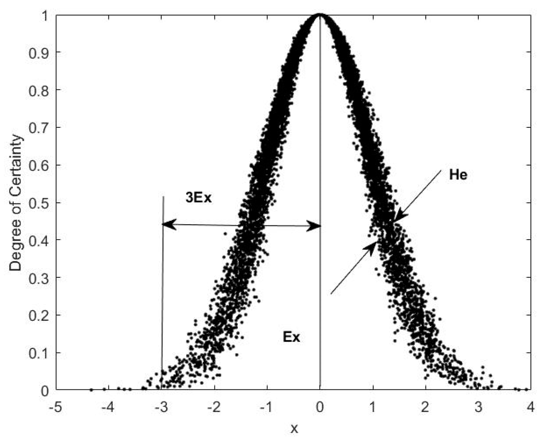
2.4.2. Forward Direction Generator of Cloud Model
2.4.3. Calculating the Characteristic Parameters of a Cloud Model
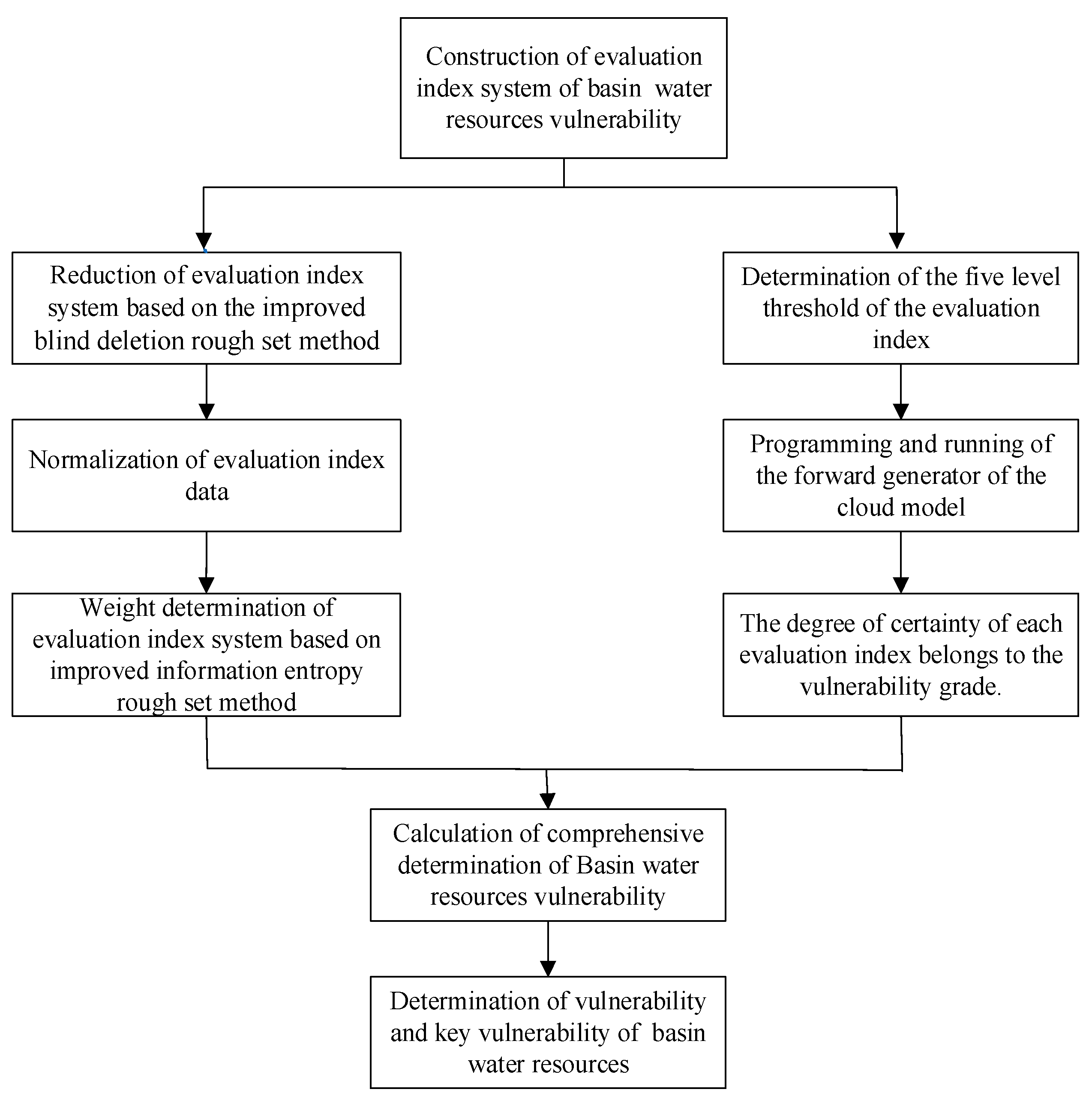
2.4.4. Steps of Vulnerability Evaluation Using Cloud Models
3. Case Study
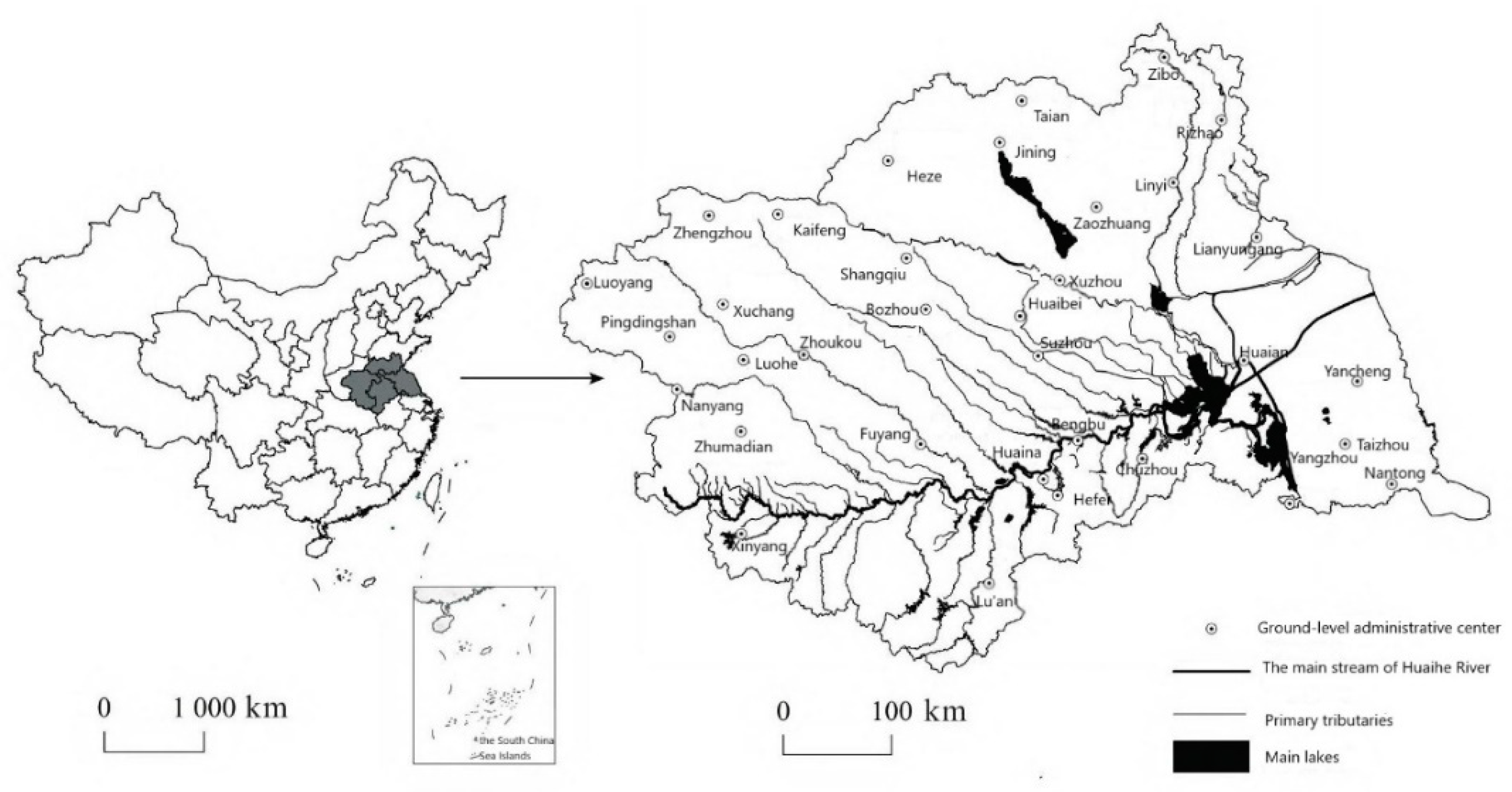
3.1. Research Area
3.2. Evaluation Grade and Trend Analysis of Water Resources Vulnerability in Huai River Basin
3.2.1. Attribute Reduction of Water Resources Vulnerability Evaluation Index
- Set up the initial index set B. We first select 12 important evaluation indicators from the original index set, that is,
- Whether the validation equation is set up. We verify that this equation is set up. It shows that the initial index set B has the same classification ability as the original conditional attribute set C and does not need to add additional index.
- Verify the necessity of each evaluation index in index set B. The verification process of each evaluation index in set B is as follows:
- According to the order of importance of the index, we select the important indexes from the set {B-N} collection to add to the collection set B:
- Through the above steps, we can get a better reduction index set , which has the same evaluation ability as the conditional attribute C. At the same time, the index is more balanced in the process of adding and can be used as the basis of cloud model calculation. We use the improved blind deletion rough set reduction method to get the evaluation index system as shown in Table 2.
3.2.2. Calculation of the Weights of Evaluation Indexes
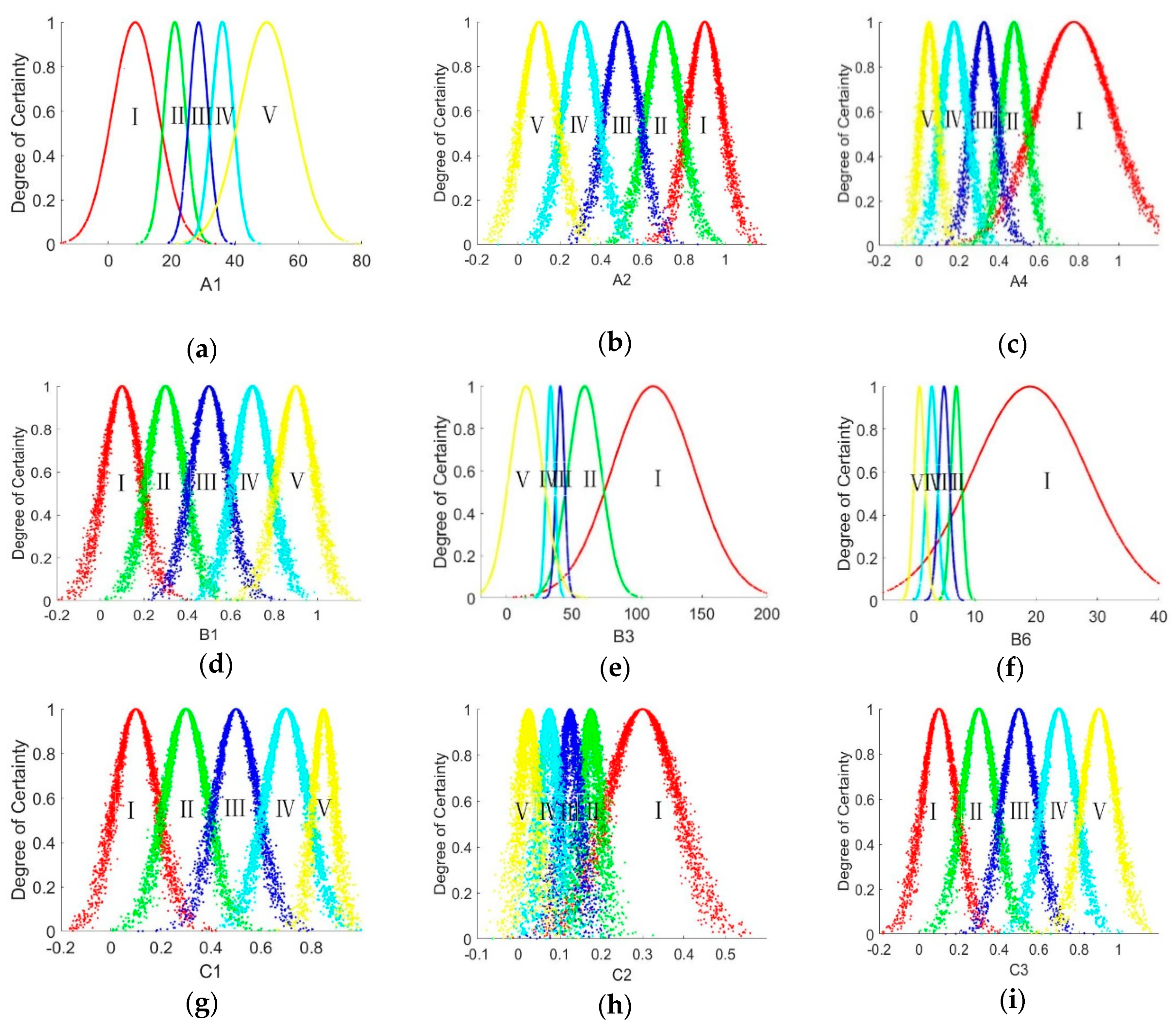
3.2.3. Calculation of the Characteristic Values and Cloud Model
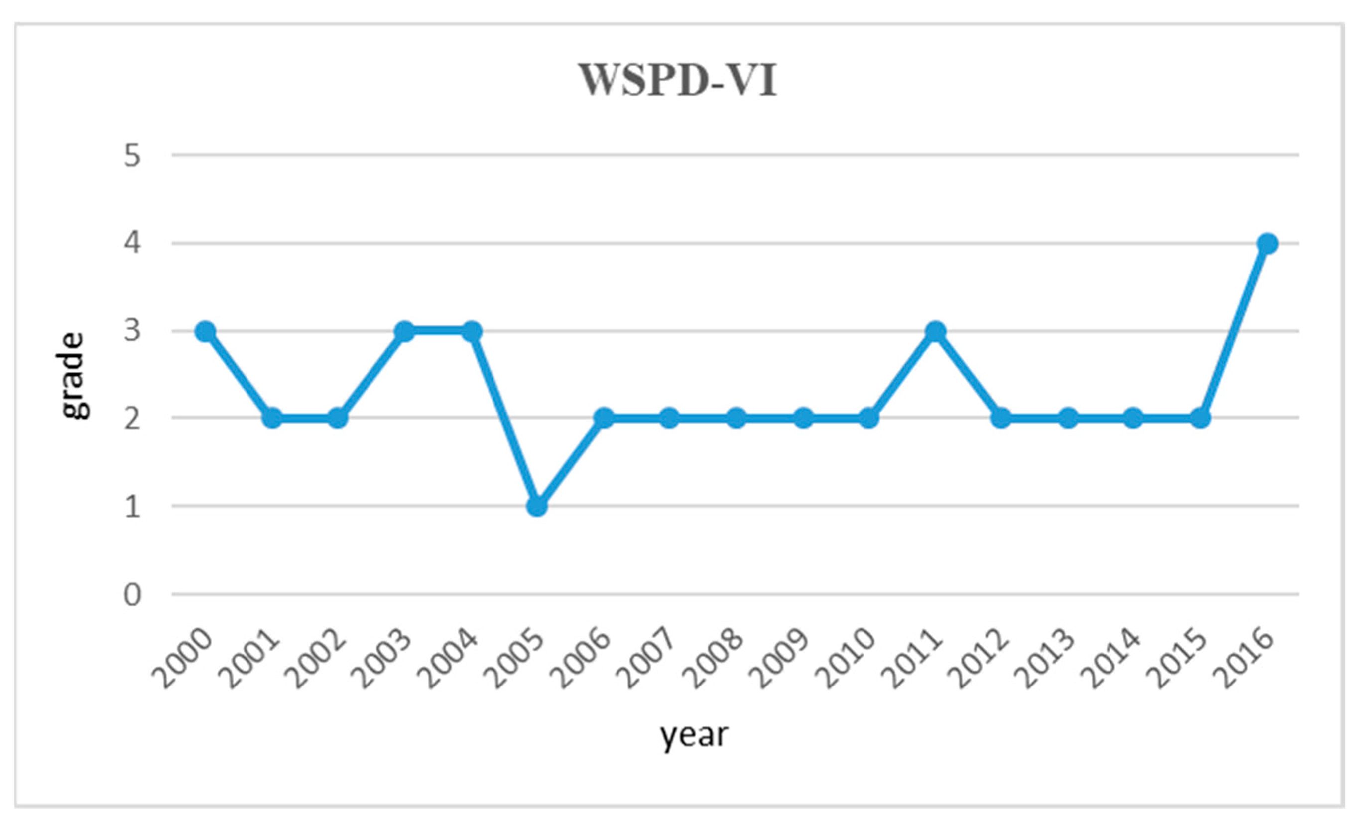
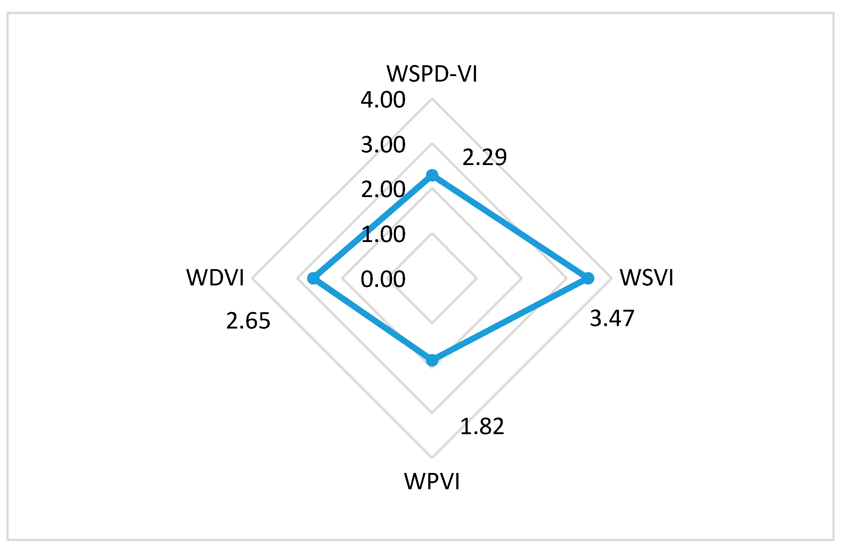
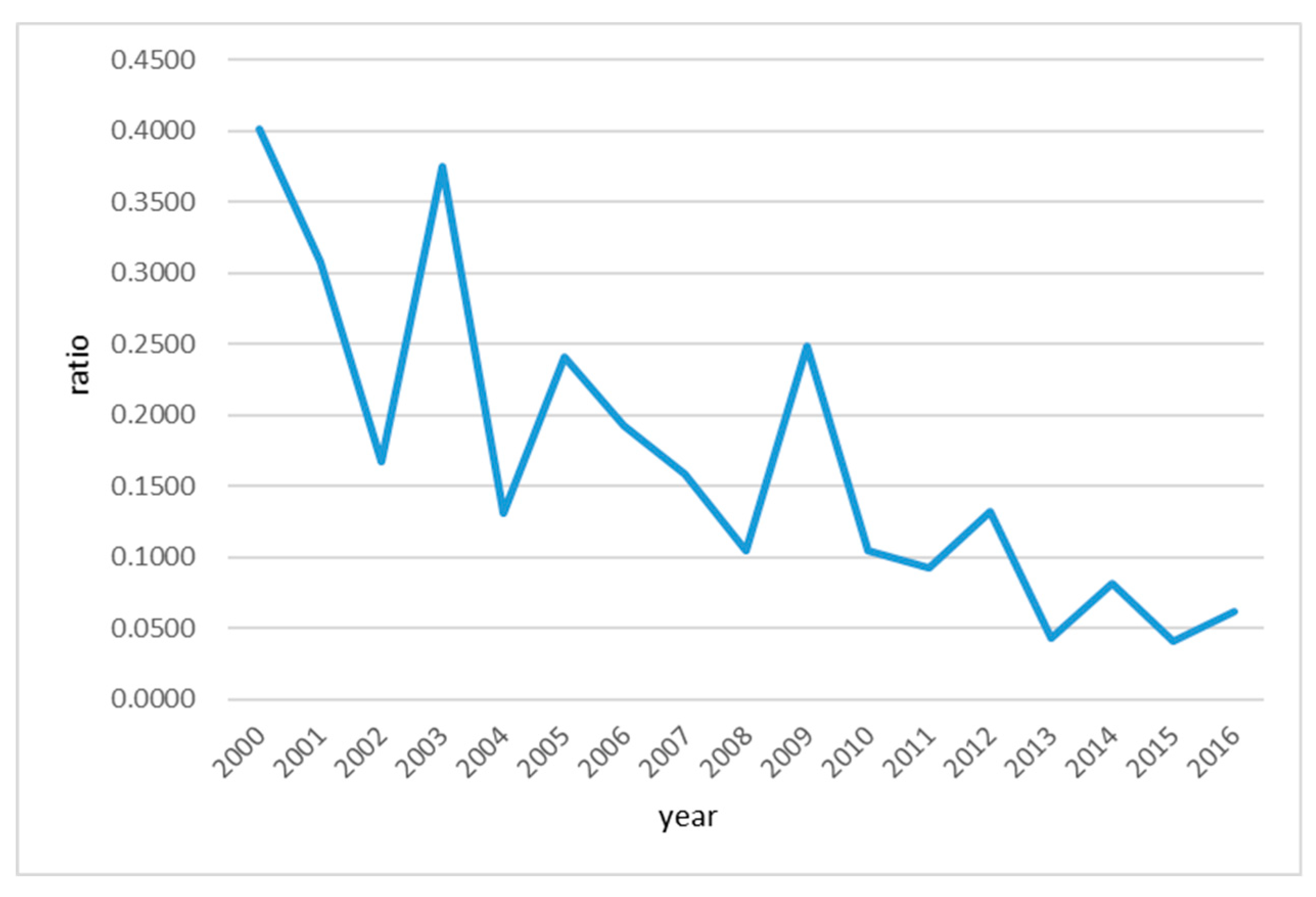
3.2.4. Degree of Certainty and Trend Analysis of Basin Water Resources Vulnerability
3.3. Identification of Key Vulnerability in Huai River Basin
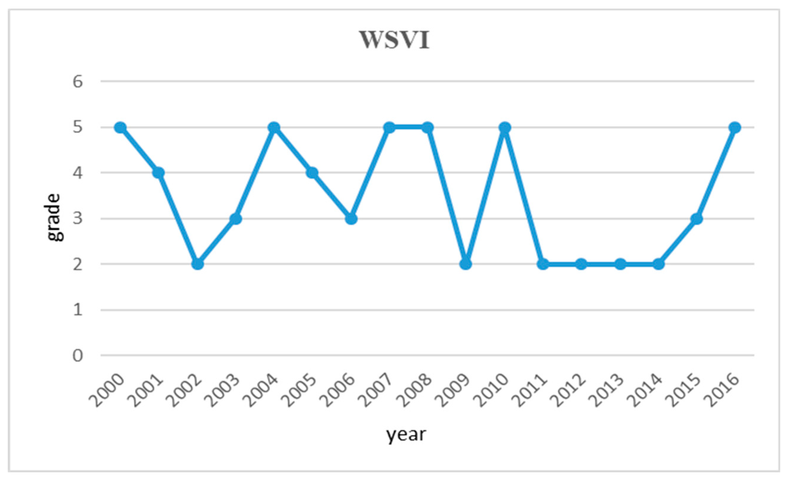
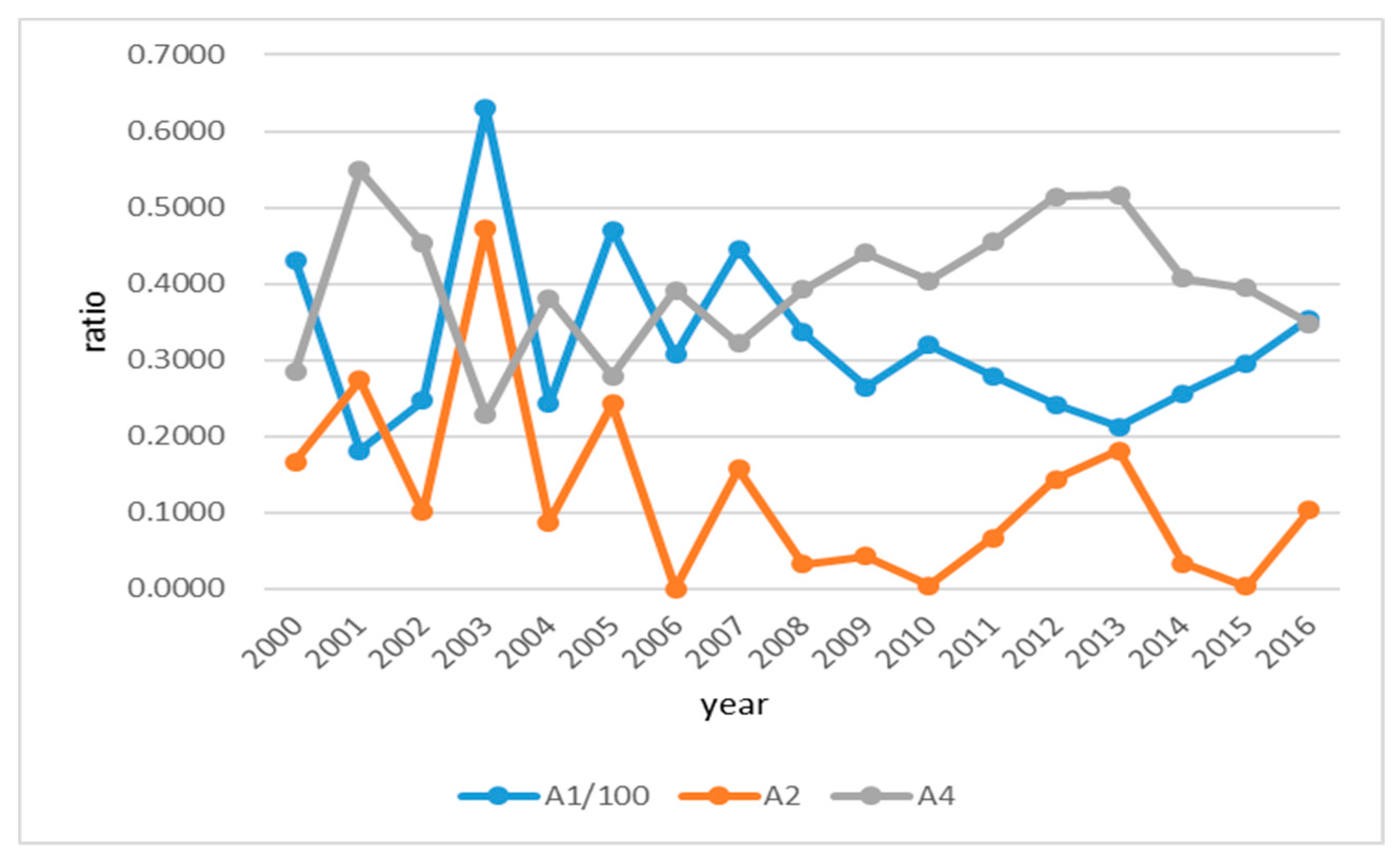
3.3.1. Analysis of the Vulnerability of Water Shortage in Huai River Basin
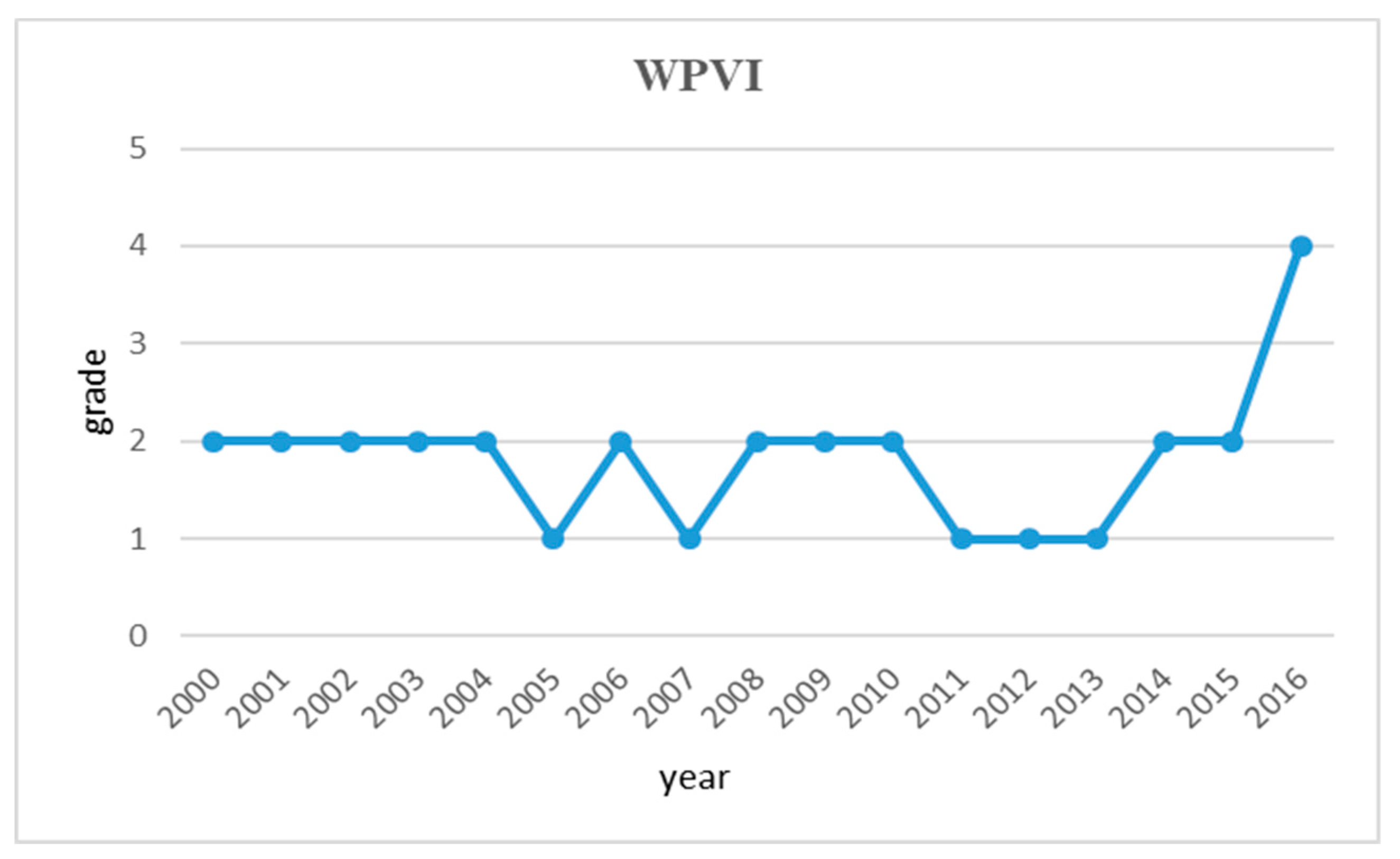
3.3.2. Analysis of the Vulnerability of Water Pollution in the Huai River Basin
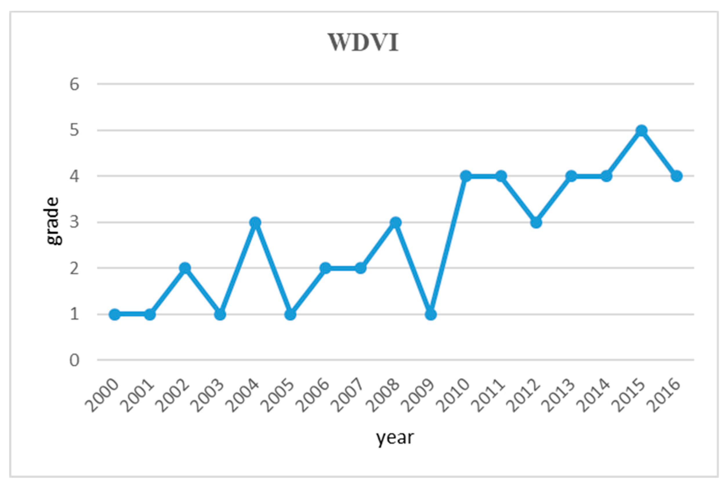
3.3.3. Analysis of the Water-related Natural Disaster Vulnerability in the Huai River Basin
3.4. Discussion of the Main Results
4. Conclusions
Author Contributions
Acknowledgments
Conflicts of Interest
Appendix A. The Details of Expert Judgement on the Importance of Attributes

| I 10 Points | II 20 Points | III 30 Points | IV 40 Points | V 50 Points | Total Score | Importance Ranking | |
|---|---|---|---|---|---|---|---|
| A1 | 2 | 3 | 5 | 430 | 1 | ||
| A2 | 2 | 2 | 3 | 2 | 1 | 280 | 6 |
| A3 | 2 | 2 | 5 | 1 | 250 | 8 | |
| A4 | 3 | 5 | 2 | 290 | 5 | ||
| A5 | 5 | 5 | 150 | 16 | |||
| A6 | 3 | 3 | 3 | 1 | 220 | 9 | |
| B1 | 5 | 3 | 2 | 170 | 13 | ||
| B2 | 4 | 3 | 2 | 1 | 200 | 10 | |
| B3 | 7 | 2 | 1 | 140 | 17 | ||
| B4 | 5 | 4 | 1 | 160 | 14 | ||
| B5 | 4 | 3 | 2 | 1 | 200 | 11 | |
| B6 | 4 | 4 | 2 | 380 | 2 | ||
| C1 | 4 | 5 | 1 | 270 | 7 | ||
| C2 | 7 | 2 | 1 | 340 | 3 | ||
| C3 | 4 | 1 | 2 | 3 | 340 | 4 | |
| C4 | 3 | 5 | 2 | 190 | 12 | ||
| C5 | 6 | 2 | 2 | 160 | 15 | ||
| C6 | 7 | 2 | 1 | 140 | 18 |
References
- Xia, J.; Qiu, B.; Li, Y. Water resources vulnerability and adaptive management in the Huang, Huai and Hai river basins of China. Water Int. 2012, 37, 523–536. [Google Scholar] [CrossRef]
- Albinet, M.; Margat, J. Cartographie de la vulnérabilité à la pollution des nappes d’eau souterraine. Bull. BRGM 1970, 4, 13–22. [Google Scholar]
- Brouwer, F.; Falkenmark, M. Climate-induced water availability changes in Europe. Environ. Monit. Assess. 1989, 13, 75–98. [Google Scholar] [CrossRef] [PubMed]
- Mirauda, D.; Ostoich, M. Surface water vulnerability assessment applying the integrity model as a decision support system for quality improvement. Environ. Impact Assess. Rev. 2011, 31, 161–171. [Google Scholar] [CrossRef]
- Houghton, J.T.; Meiro Filho, L.G.; Callander, B.A.; Harris, N.; Kattenburg, A.; Maskell, K. Climate Change 1995: The Science of Climate Change, 1st ed.; Cambridge University Press: Cambridge, UK, 1996; pp. 572–584. [Google Scholar]
- Zhou, J.B.; Zou, J. Vulnerability assessment of water resources to climate change in Chinese cities. Ecol. Econ. 2010, 6, 106–114. [Google Scholar]
- Farley, K.A.; Tague, C.; Grant, G.E. Vulnerability of water supply from the Oregon Cascades to changing climate: Linking science to users and policy. Glob. Environ. Chang. 2011, 21, 110–122. [Google Scholar] [CrossRef]
- Xia, J.; Luo, X.; Cao, J.; Chen, J.; Ning, L.; Hong, S. Impact and assessment of climate change on the water resources vulnerability in the Eastern China monsoon region. Prog. Inquisitiones Mutatione Clim. 2015, 1, 8–14. [Google Scholar]
- Xia, J.; Shi, W.; Chen, J.; Hong, S. Study on vulnerability of water resources and its adaptive regulation under changing environment: A case of Haihe River basin. Water Resour. Hydropower Eng. 2015, 6, 27–33. [Google Scholar]
- Li, C.; Wang, H.; Tong, J.; Li, R. Vulnerability assessment of water resources adaptive system facing climate change: A case of the Poyang lake basin. Resour. Environ. Yangtze Basin 2013, 2, 172–181. [Google Scholar]
- Baubion, C.; Marsily, G. Water resources assessment in the Huai River basin: Hydrological modelling and remote sensing. Dragon Program. Mid-Term Results Proc. 2006, 611, 245–260. [Google Scholar]
- Chen, J.; Xia, J. Using the RESC Model and Diversity Indexes to Assess the Cross-Scale Water Resource Vulnerability and Spatial Heterogeneity in the Huai River Basin, China. Water 2016, 8, 431. [Google Scholar] [CrossRef]
- Xia, J.; Bing, Q.; Xingyao, P.; Jianwu, W.; Guobin, F.; Rulin, O. Assessment of water resources vulnerability under climate change and human activities. Adv. Earth Sci. 2012, 27, 443–451. [Google Scholar]
- Xia, J.; Weng, J.; Chen, J. Multi-scale water vulnerability assessment research. J. Basic Sci. Eng. 2012, 20, 1–14. [Google Scholar]
- Tang, G.; Li, X.; Liu, Y. Assessment method of vulnerability of water resources under global climate change. Adv. Earth Sci. 2000, 15, 313–317. [Google Scholar]
- Perveen, S.; James, L.A. Scale invariance of water stress and scarcity indicators: Facilitating cross-scale comparisons of water resources vulnerability. Appl. Geogr. 2011, 31, 321–328. [Google Scholar] [CrossRef]
- Busey, R.; Hinzman, L.; White, D. Freshwater vulnerabilities and resilience on the Seward Peninsula: Integrating multiple dimensions of landscape change. Glob. Environ. Chang. 2008, 18, 256–270. [Google Scholar]
- Ngcobo, S.; Jewitt, G.P.; Stuart-Hill, S.I.; Warburton, M.L. Impacts of global change on southern African water resources systems. Curr. Opin. Environ. Sustain. 2013, 5, 655–666. [Google Scholar] [CrossRef]
- Zghibi, A.; Merzougui, A.; Chenini, I.; Ergaieg, K.; Zouhri, L.; Tarhouni, J. Groundwater vulnerability analysis of Tunisian coastal aquifer: An application of DRASTIC index method in GIS environment. Groundw. Sustain. Dev. 2016, 2, 169–181. [Google Scholar] [CrossRef]
- Jun, K.; Chung, E.; Sung, J.; Lee, K. Development of spatial water resources vulnerability index considering climate change impacts. Sci. Total Environ. 2011, 409, 5228–5242. [Google Scholar] [CrossRef] [PubMed]
- Aydi, A. Evaluation of groundwater vulnerability to pollution using a GIS-based multi-criteria decision analysis. Groundw. Sustain. Dev. 2018, 7, 204–211. [Google Scholar] [CrossRef]
- Rajesh, S.; Jain, S.; Sharma, P. Inherent vulnerability assessment of rural households based on socio-economic indicators using categorical principal component analysis: A case study of Kimsar region, Uttarakhand. Ecol. Indic. 2018, 85, 93–104. [Google Scholar] [CrossRef]
- Xu, H.; Ma, C.; Lian, J.; Xu, K.; Chaima, E. Urban flooding risk assessment based on an integrated k-means cluster algorithm and improved entropy weight method in the region of Haikou, China. J. Hydrol. 2018, 8, 975–986. [Google Scholar] [CrossRef]
- Yilmaz, L. Chaos in the water resources system. Appl. Math. Comput. 2006, 183, 761–773. [Google Scholar] [CrossRef]
- Deng, X.; Xu, Y.; Han, L.; Yu, Z.; Yang, M.; Pan, G. Assessment of river health based on an improved entropy-based fuzzy matter-element model in the Taihu Plain, China. Ecol. Indic. 2015, 57, 85–95. [Google Scholar] [CrossRef]
- Feng, S.; Li, J.; Zhu, Z.; Zhong, Y.; Lei, X. Vulnerability evaluation of water resources in central Yunnan province. Water Resour. Prot. 2010, 1, 13–16. [Google Scholar]
- Jiang, X.; Xu, S.; Liu, Y.; Wang, X. River ecosystem assessment and application in ecological restorations: A mathematical approach based on evaluating its structure and function. Ecol. Eng. 2015, 76, 151–157. [Google Scholar] [CrossRef]
- Cheng, C.T.; Chau, K.W. Flood control management system for reservoirs. Environ. Model. Softw. 2004, 19, 1141–1150. [Google Scholar] [CrossRef]
- Fotovatikhah, F.; Herrera, M.; Shamshirband, S.; Chau, K.W.; Faizollahzadeh Ardabili, S.; Piran, M.J. Survey of Computational Intelligence as Basis to Big Flood Management: Challenges, research directions and Future Work. Eng. Appl. Comput. Fluid Mech. 2018, 12, 411–437. [Google Scholar] [CrossRef]
- Taormina, R.; Chau, K.W.; Sivakumar, B. Neural network river forecasting through base flow separation and binary-coded swarm optimization. J. Hydrol. 2015, 529, 1788–1797. [Google Scholar] [CrossRef]
- Wu, C.L.; Chau, K.W. Rainfall-Runoff Modeling Using Artificial Neural Network Coupled with Singular Spectrum Analysis. J. Hydrol. 2011, 399, 394–409. [Google Scholar] [CrossRef]
- Wang, W.C.; Xu, D.M.; Chau, K.W.; Chen, S. Improved annual rainfall-runoff forecasting using PSO-SVM model based on EEMD. J. Hydroinform. 2013, 15, 1377–1390. [Google Scholar] [CrossRef]
- Chau, K.W. Use of Meta-Heuristic Techniques in Rainfall-Runoff Modelling. Water 2017, 9, 186. [Google Scholar] [CrossRef]
- Chen, J.; Hong, J.; Liao, S.; Weng, Q.; Weng, J. Progress of research in water resources key vulnerability identification and the adaptation measures. Yellow River 2013, 35, 24–26. [Google Scholar]
- Pawlak, Z. Rough set approach to knowledge-based decision support. Eur. J. Oper. Res. 1997, 99, 48–57. [Google Scholar] [CrossRef]
- Liu, Q.; Chen, Y. Vulnerability prediction of basin water resources on rough set and BP neural network: A case of Huai River basin. Resour. Environ. Yangtze Basin 2016, 25, 1317–1327. [Google Scholar]
- Che, X.; Mi, J.; Chen, D. Information fusion and numerical characterization of a multi-source information system. Knowl. Based Syst. 2018, 145, 121–133. [Google Scholar] [CrossRef]
- Wang, H.; Wang, G.; Zeng, X.; Peng, S. Online streaming feature selection based on conditional information entropy. In Proceedings of the 2017 IEEE International Conference on Big Knowledge (ICBK), Hefei, China, 9–10 August 2017; pp. 230–235. [Google Scholar]
- Gao, X.; Chen, L.; Sun, B.; Liu, Y. Employing SWOT analysis and normal cloud model for water resource sustainable utilization assessment and strategy development. Sustainability 2017, 9, 1439. [Google Scholar]
- Li, D.; Liu, C.; Gan, W. A new cognitive model: Cloud model. Int. J. Intell. Syst. 2009, 24, 357–375. [Google Scholar] [CrossRef]
- Pan, Z.; Ruan, X.; Qian, M.; Hua, J.; Shan, N.; Xu, J. Spatio-temporal variability of streamflow in the Huai River basin, China: Climate variability or human activities? Hydrol. Res. 2018, 49, 177–193. [Google Scholar] [CrossRef]
- Raza, M.S.; Qamar, U. A heuristic based dependency calculation technique for rough set theory. Pattern Recognit. 2018, 81, 309–325. [Google Scholar] [CrossRef]
- Dai, J.; Yan, Y.; Li, Z.; Liao, B. Dominance-based fuzzy rough set approach for incomplete interval-valued data. J. Intell. Fuzzy Syst. 2018, 34, 423–436. [Google Scholar] [CrossRef]
- Wang, X.; Zhang, J.; Shahid, S.; Xie, W.; Du, C.; Shang, X.; Zhang, X. Modeling domestic water demand in Huai River basin of China under climate change and population dynamics. Environ. Dev. Sustain. 2018, 2, 911–924. [Google Scholar] [CrossRef]
- Dou, M.; Zhang, Y.; Li, G. Temporal and spatial characteristics of the water pollutant concentration in Huaihe River Basin from 2003 to 2012, China. Environ. Monit. Assess. 2016, 188, 1123–1140. [Google Scholar] [CrossRef] [PubMed]
- Xiao, M.; Bao, F.; Wang, S.; Cui, F. Water quality assessment of the Huai River segment of Bengbu (China) using multivariate statistical techniques. Water Resour. 2016, 43, 166–176. [Google Scholar] [CrossRef]
- Wu, Y.; Zhong, P.; Xu, B.; Zhu, F.; Ma, B. Changing of flood risk due to climate and development in Huai River basin, China. Stoch. Environ. Res. Risk Assess. 2017, 31, 935–948. [Google Scholar] [CrossRef]


| Evaluation Index System | Attribute Sign | ||
|---|---|---|---|
| Water shortage vulnerability (WSVI) | Natural vulnerability | Water yield per km2 A1 | positive |
| Absolute value of variation coefficient of annual precipitation A2 | negative | ||
| Man-made vulnerability | The proportion of surface water resources being utilized A3 | negative | |
| The proportion of groundwater resources being utilized A4 | negative | ||
| Vulnerability of carrying capacity | Per capita water consumption A5 | negative | |
| Water consumption for irrigation per mu A6 | negative | ||
| Water pollution vulnerability (WPVI) | Natural vulnerability | Water quality examination pass rate in water function area B1 | positive |
| The decline rate of water quality examination pass rate B2 | negative | ||
| Man-made vulnerability | Total COD emission per 10,000 people B3 | negative | |
| Total ammonia and nitrogen emission per 10,000 people B4 | negative | ||
| Vulnerability of carrying capacity | Ecosystem water consumption B5 | positive | |
| Wastewater generation per 10,000-yuan GDP B6 | negative | ||
| Water-related natural disaster vulnerability (WDVI) | Natural vulnerability | Water yield coefficient C1 | positive |
| Proportion of area affected by flood and drought C2 | negative | ||
| Man-made vulnerability | The proportion of soil erosion being controlled C3 | positive | |
| The proportion of farmland area being the effectively irrigated C4 | positive | ||
| Vulnerability of carrying capacity | Proportion of population under levee protection C5 | positive | |
| Regulation and storage capacity of water conservancy projects C6 | positive | ||
| Evaluation Index System | Weight | |
|---|---|---|
| WSVI | Water yield per km2 A1 | 0.0517 |
| Absolute value of variation coefficient of annual precipitation A2 | 0.1313 | |
| The proportion of groundwater resources being utilized A4 | 0.1348 | |
| WPVI | Water quality examination pass rate in water function area B1 | 0.1454 |
| Total COD emission per 10,000 people B3 | 0.1371 | |
| Wastewater generation per 10,000-yuan GDP B6 | 0.1422 | |
| WDVI | Water yield coefficient C1 | 0.0528 |
| Proportion of area affected by flood and drought C2 | 0.1380 | |
| The proportion of soil erosion being controlled C3 | 0.0667 | |
| Indicator | Grading Standard of Basin Water Resource Vulnerability | ||||
|---|---|---|---|---|---|
| Extreme Vulnerability (1st Level) | Severe Vulnerability (2nd Level) | Moderate Vulnerability (3rd Level) | Mild Vulnerability (4th Level) | Not Vulnerability (5th Level) | |
| A1 | 0~17 | 17~25 | 25~32 | 32~40 | 40~60 |
| A2 | 80%~100% | 60%~80% | 40%~60% | 20%~40% | 0~20% |
| A4 | 55%~100% | 40%~55% | 25%~40% | 10%~25% | 0~10% |
| B1 | 0~20% | 20%~40% | 40%~60% | 60%~80% | 80%~100% |
| B3 | 75~150 | 45~75 | 37.5~45 | 30~37.5 | 0~30 |
| B6 | 8~30 | 6~8 | 4~6 | 2~4 | 0~2 |
| C1 | 0~20% | 20%~40% | 40%~60% | 60%~80% | 80%~90% |
| C2 | 20%~40% | 15%~20% | 10%~15% | 5%~10% | 0~5% |
| C3 | 0~20% | 20%~40% | 40%~60% | 60%~80% | 80%~100% |
| Year | WSPD-VI | WSVI | WPVI | WDVI |
|---|---|---|---|---|
| Degree | Degree | Degree | Degree | |
| 2000 | 3 | 5 | 2 | 1 |
| 2001 | 2 | 4 | 2 | 1 |
| 2002 | 2 | 2 | 2 | 2 |
| 2003 | 3 | 3 | 2 | 1 |
| 2004 | 3 | 5 | 2 | 3 |
| 2005 | 1 | 4 | 1 | 1 |
| 2006 | 2 | 3 | 2 | 2 |
| 2007 | 2 | 5 | 1 | 2 |
| 2008 | 2 | 5 | 2 | 3 |
| 2009 | 2 | 2 | 2 | 1 |
| 2010 | 2 | 5 | 2 | 4 |
| 2011 | 3 | 2 | 1 | 4 |
| 2012 | 2 | 2 | 1 | 3 |
| 2013 | 2 | 2 | 1 | 4 |
| 2014 | 2 | 2 | 2 | 4 |
| 2015 | 2 | 3 | 2 | 5 |
| 2016 | 4 | 5 | 4 | 4 |
| Mean value | 2.29 | 3.47 | 1.82 | 2.65 |
© 2018 by the authors. Licensee MDPI, Basel, Switzerland. This article is an open access article distributed under the terms and conditions of the Creative Commons Attribution (CC BY) license (http://creativecommons.org/licenses/by/4.0/).
Share and Cite
Chen, Y.; Feng, Y.; Zhang, F.; Wang, L. Assessing Water Resources Vulnerability by Using a Rough Set Cloud Model: A Case Study of the Huai River Basin, China. Entropy 2019, 21, 14. https://doi.org/10.3390/e21010014
Chen Y, Feng Y, Zhang F, Wang L. Assessing Water Resources Vulnerability by Using a Rough Set Cloud Model: A Case Study of the Huai River Basin, China. Entropy. 2019; 21(1):14. https://doi.org/10.3390/e21010014
Chicago/Turabian StyleChen, Yan, Yazhong Feng, Fan Zhang, and Lei Wang. 2019. "Assessing Water Resources Vulnerability by Using a Rough Set Cloud Model: A Case Study of the Huai River Basin, China" Entropy 21, no. 1: 14. https://doi.org/10.3390/e21010014
APA StyleChen, Y., Feng, Y., Zhang, F., & Wang, L. (2019). Assessing Water Resources Vulnerability by Using a Rough Set Cloud Model: A Case Study of the Huai River Basin, China. Entropy, 21(1), 14. https://doi.org/10.3390/e21010014