Abstract
This study investigates the sensitivity of an urban parameterization scheme of the Weather Research and Forecasting model (WRF). The model sensitivity is tested during the period April–May 2020 over the greater Paris region. The parent domain covers Europe with a 12 km horizontal resolution, with a nested one covering the greater Paris region with a 3 km horizontal resolution. A multi-layer urban scheme called Building Effect Parameterization coupled with the Building Energy Model (BEP-BEM) was applied in two simulations: (1) BEP-BEM Paris, with urban options tailored for the Paris region, which were derived from Earth Observation data, and (2) BEP-BEM Europe, which uses an updated urban parameter table with an estimated average profile for European cities. These two simulations were compared with observations and a WRF simulation using a simple urban parameterization (BULK approach). BULK and multi-layer urban scheme experiments present a similar general error for April, underestimating temperature, while the BEP-BEM runs overestimate temperature for May. The simulation with the advanced tailored urban parameterization over Paris appears to have the best overall performance in this 2-month period.
1. Introduction
Urban areas are responsible for a large contribution to a wide range of environmental issues, from global (climate change) to local (air pollution and thermal stress) scales. This is caused by the ongoing and projected rapid growth of the population living in cities [1]. Hence, the importance of urban planning in mitigating the impact of cities on their inhabitants from social, environmental, and health perspectives has emerged.
Anthropogenic activities (industry, traffic, domestic heating/cooling) and urban surface materials, which retain more energy than those in rural areas, modify the urban atmosphere. To better understand these processes, parameterization schemes concerning the urban environment have been developed and integrated into atmospheric models. These parameterizations take into consideration characteristics such as the effect of building height, street and building width, anthropogenic heating, albedo, and emissivity of materials.
The goal of this study is to evaluate the performance of WRF multi-layer urban scheme BEP-BEM, having the greater Paris region as a case study. One of the novelties of this study resides in the modification of this urban scheme by altering some of the default parameters that it integrates and by using tailored urban characteristics derived from high-resolution Earth Observation data, specifically for the Paris region.
2. Data and Methodology
2.1. Model Set-Up
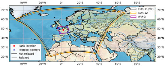
In this study, the non-hydrostatic Weather Research and Forecasting (WRFv4.5.1) [2] model was utilized. The basic domain configurations and model set-up follow the WCRP-CORDEX-Flagship Pilot Study (FPS) URBan environments and Regional Climate Change (URB-RCC) [3]. The FPS URB-RCC enables a better assessment of processes and phenomena relevant to regional climate, in which the urban environment is included [4]. The domain consisted of two nests covering Europe (d01) and the bigger part of France (d02), while the horizontal grid spacings were 12 km and 3 km, respectively (Figure 1). All three runs were driven by the ECMWF ERA-5 reanalysis dataset (0.25° × 0.25°) at six hourly intervals. Each model run was initialized on March 1st at 00 UTC, and the duration of each simulation was three months. All simulations used the first month (March 2020) as spin-up time. Moreover, 59 vertical levels were considered with increased resolution in the boundary layer.

Figure 1.
Domain configuration. EUR-12 (colored yellow) represents the outer d01 domain, which was selected in such a way to fit the EURO-CORDEX domain (colored black). PAR-3 (colored purple) represents the inner d02 domain, while the red dot points to Paris.
The NOAH-MP was used as a land surface model, while the Thompson microphysics scheme was employed for the representation of microphysical processes. Furthermore, longwave and shortwave radiation were represented by the RRTMG schemes, and the BouLac PBL scheme was used, since it is the PBL scheme that has been tested most extensively with BEP-BEM. These parameterizations were used for all simulations and both domains, while for the outer domain, the sub-grid-scale convection was parameterized by the Kain–Fritsch scheme.
2.2. Urban Modeling System
Urban canopy schemes have been developed and integrated into WRF as part of its physics options. These advanced urban models are tailored to realistically represent urban form—such as the geometry of buildings and street canyons—as well as surface properties like albedo, heat capacity, emissivity, and the distribution of urban and vegetated areas. BEP-BEM [5] is the most sophisticated urban scheme available in WRF, as it is the second generation of BEP that considers energy consumption in buildings (heating/cooling) for a more accurate effect on urban heat budget. The BEP component simulates how buildings influence airflow and turbulence—by adding terms to the Turbulent Kinetic Energy (TKE) conservation equation—and accounts for heat sources and sinks by solving the energy balance for each surface. Meanwhile, the BEM component estimates anthropogenic heat released by air conditioning systems and models heat exchanges between building interiors and the surrounding atmosphere. Characteristics such as building height, roof and road width, and the albedo and emissivity of materials are used as inputs for urban physics schemes and are stored in a lookup table called URBPARM_LCZ.TBL. WRF includes a default lookup table with typical values for these parameters. However, this table is not hardcoded, allowing users the flexibility to modify or replace it with more accurate, location-specific data for the area of interest (AOI).
Since the Paris region is the AOI, the BEP-BEM Paris simulation uses urban characteristics specifically tailored for Paris. These were derived from high-resolution Earth Observation data, including building height, roof and road width, and fraction of the urban landscape without natural vegetation, from the Copernicus Land Monitoring Service, albedo from Sentinel-2, and emissivity from ECOSTRESS, and were implemented into the lookup table.
For the BEP-BEM Europe run, the lookup table used is the one adopted in the STAGE-0 simulations of FPS-URB-RCC. This table contains several modifications from WRF’s default version, aiming to better represent urban characteristics of European cities—with Madrid used as the reference city.
The BULK run, which has no urban physics options turned on, follows the modification of some parameters inside NOAH-MP regarding grid cells that have an urban land-use category [6]. In this way, urban areas are better represented with respect to wind speed and heat storage capacity.
2.3. Observations and Land Use
Surface observations from 51 stations of Meteo-France RADOME network, surrounding Paris region, have been used to evaluate WRF simulations. RADOME has classified these stations in two main categories: (1) urban stations, and (2) crops and forest stations.
All the runs use a land cover map based on LANDMATE PFT data translated into the standard IGBP MODIS classes present in WRF. For BEP-BEM runs, the urban areas are represented by the WUDAPT Local Climate Zones (LCZ) [7,8] (Figure 2a). The LCZ system includes 17 land-use types, with 10 focused on urban areas. The BEP-BEM scheme uses the 10 urban classes plus the “Bare rock or paved” (considered as asphalt, class E), offering more detail and discretization for urban cells than category 13 (“Urban and Built-Up”) of IGBP MODIS.

Figure 2.
Land-use in the Paris region (Île-de-France): (a) BEP-BEM runs; (b) BULK run. Black dots indicate the location of stations.
On the other hand, the BULK run used 1 land-use class (category 13), instead of 10, for all urban cells (Figure 2b). Therefore, BULK does not allow the discretization of urban areas into different land use and physical property classes [9], unlike BEP-BEM as mentioned above. Furthermore, the use of 1 urban class instead of 10 reduces computation time, this is why this approach has been employed in real-time weather forecasts.
3. Results
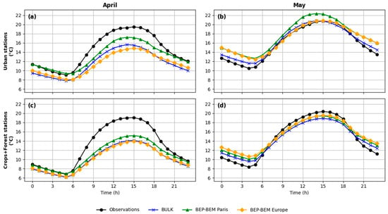
In an effort to investigate whether the station types indicated by the RADOME network match the land-use categories represented in the simulations, it was found that 10 out of 51 stations do not match the real land use due to the resolution of the model grid. As a result, mean daily cycles of 2 m temperature for each month were generated for two land-use groups—urban stations and crops/forest stations—using the remaining 41 stations, for which the real land-use type coincides with that in the simulations. Figure 3a,c shows that for April, all three simulations underestimate temperature during sunlight hours in both urban and crops/forest stations, with BEP-BEM Paris having the smallest bias in both occasions. Furthermore, the BEP-BEM Paris run appears to have a better performance for nighttime temperatures. This may be due to the use of exact building heights tailored for Paris, leading to a more accurate representation of the trapping of longwave radiation by the height of buildings. As for May (Figure 3b,d), all three simulations tend to overestimate nighttime temperatures for urban and crops/forest stations, while BEP-BEM Europe appears to be more precise on sunlight hours. BEP-BEM Paris slightly overestimates temperature throughout the whole day, especially for urban stations for this month. Despite being the simplest and least computationally demanding configuration, the BULK run shows good performance for May, reaching the precision of BEP-BEM runs.

Figure 3.
Daily profiles of 2 m temperature of observations (black), BULK (blue), BEP-BEM Paris (green), and BEP-BEM Europe (orange) for: (a) urban stations in April; (b) urban stations in May; (c) crops/forest stations in April; (d) crops/forest stations in May.
Table 1 presents a statistical analysis of the simulations’ performance using the correlation coefficient (R), bias, and root mean square error (RMSE) across all 51 stations—including those with land-use mismatches—in order to assess the overall behavior of the simulations, throughout the 2-month period. All three simulations exhibit a similar error pattern: underestimation of 2 m temperature (bias < 0 °C), with BEP-BEM Paris showing the smallest bias. Although BULK has the largest bias, its correlation with observations is comparable to that of the BEP-BEM runs, outperforming BEP-BEM Europe in RMSE too. BEP-BEM Paris simulation appears to have better overall performance in this 2-month spell.

Table 1.
Statistical analysis of (R, Bias, and RMSE) BULK, BEP-BEM Paris, and BEP-BEP Europe performance, concerning 2 m temperature.
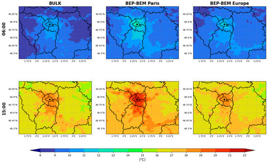
At the time of the daily minimum temperature (06:00 AM), the BEP-BEM Paris simulation shows a sharper temperature gradient between the city of Paris and the surrounding rural areas, as illustrated in Figure 4. This occurs because, as previously mentioned, the simulation includes detailed urban characteristics specific to Paris, such as building structures and street canyons, to more realistically represent air flow and heat fluxes within the urban environment. A similar pattern is observed at 15:00 PM, suggesting that BEP-BEM Paris potentially captures the urban heat island effect more effectively.

Figure 4.
2 m temperature at 06:00 AM and 15:00 PM local time, with respect to April–May 2020: BULK (left panel), BEP-BEM Paris (central panel), and BEP-BEM Europe (right panel). The black dot marks the center of Paris.
4. Conclusions
High-quality input data and parameterizations are essential for achieving accurate modeling results. In this study, the BEP-BEM urban scheme of WRF was tested using detailed urban characteristics specifically tailored for Paris. The results were then analyzed and compared against a default WRF set-up (BULK), a BEP-BEM configuration modified to better represent average urban characteristics of European cities, and observational data. The focus of the evaluation was 2 m temperature.
Although the evaluation period (April–May) is marked by greater variability compared to other months, due to its transitional nature, the BEP-BEM Paris simulation performed adequately, generally outperforming the other two simulations. Given that the BEP-BEM scheme can incorporate more urban-specific data—such as anthropogenic heat generated by air conditioning systems and household equipment—it is recommended that future studies also include energy-related data to fully leverage the capabilities of this scheme.
Author Contributions
Conceptualization, E.K. and V.P.; methodology, I.K., V.P. and E.K.; software and analysis, I.K. and M.G.; validation, I.K. and M.G.; investigation, V.P., I.K. and Z.M.; resources, E.K.; data curation, V.P. and I.K.; writing—original draft preparation, I.K.; writing—review and editing, E.K., V.P., Z.M. and N.C.; visualization, I.K.; supervision, E.K.,V.P. and N.C.; project administration, E.K.; funding acquisition, E.K. All authors have read and agreed to the published version of the manuscript.
Funding
The research project was implemented in the framework of H.F.R.I. called “Basic Research Financing (Horizontal Support of All Sciences)” under the National Recovery and Resilience Plan “Greece 2.0”, funded by the European Union–NextGenerationEU (H.F.R.I. Project Number: 14696).
Institutional Review Board Statement
Not applicable for this study.
Informed Consent Statement
Not applicable for this study.
Data Availability Statement
Meteo-France RADOME Network “https://www.aeris-data.fr/en/projects/observation-data-from-the-meteo-france-ground-based-observation-network/ (accessed on 1 June 2025)”; LANDMATE PFT landcover dataset for Europe 2015 (Version 1.0) “https://www.wdc-climate.de/ui/entry?acronym=LM_PFT_LandCov_EUR2015_v1.0 (accessed on 1 June 2025)”.
Acknowledgments
The authors acknowledge the support of the Greek Research and Technology Network (GRNET) High Performance Computing (HPC) infrastructure for providing the computational resources of AUTH simulations (under project IDs pr016029_thin and pr017036_thin) and the AUTH Scientific Computing Center for technical support.
Conflicts of Interest
The authors declare no conflicts of interest. The funders had no role in the design of the study; in the collection, analysis, or interpretation of data; in the writing of the manuscript; or in the decision to publish the results.
References
- World Health Organization. Global Report on Urban Health: Equitable, Healthier Cities for Sustainable Development; WHO Kobe Centre: Kobe, Japan, 2016; ISBN 9789241565271. [Google Scholar]
- Skamarock, W.C.; Klemp, J.B.; Dudhia, J.; Gill, D.O.; Liu, Z.; Berner, J.; Wang, W.; Powers, J.G.; Duda, M.G.; Barker, D.M.; et al. A Description of the Advanced Research WRF Model Version 4; NCAR: Boulder, CO, USA, 2021. [Google Scholar]
- Langendijk, G.S.; Halenka, T.; Hoffmann, P.; Adinolfi, M.; Aldama Campino, A.; Asselin, O.; Bastin, S.; Bechtel, B.; Belda, M.; Bushenkova, A.; et al. Towards Better Understanding the Urban Environment and Its Interactions with Regional Climate Change—The WCRP CORDEX Flagship Pilot Study URB-RCC. Urban Clim. 2024, 58, 102165. [Google Scholar] [CrossRef]
- Katragkou, E.; Sobolowski, S.P.; Teichmann, C.; Solmon, F.; Pavlidis, V.; Rechid, D.; Hoffmann, P.; Fernandez, J.; Nikulin, G.; Jacob, D. Delivering an Improved Framework for the New Generation of CMIP6-Driven EURO-CORDEX Regional Climate Simulations. Bull. Am. Meteorol. Soc. 2024, 105, E962–E974. [Google Scholar] [CrossRef]
- Salamanca, F.; Krpo, A.; Martilli, A.; Clappier, A. A New Building Energy Model Coupled with an Urban Canopy Parameterization for Urban Climate Simulations-Part I. Formulation, Verification, and Sensitivity Analysis of the Model. Theor. Appl. Climatol. 2010, 99, 331–344. [Google Scholar] [CrossRef]
- Liu, Y.; Chen, F.; Warner, T.; Basara, J. Verification of a Mesoscale Data-Assimilation and Forecasting System for the Oklahoma City Area during the Joint Urban 2003 Field Project. J. Appl. Meteorol. Climatol. 2006, 45, 912–929. [Google Scholar] [CrossRef]
- Stewart, I.D.; Oke, T.R. Local Climate Zones for Urban Temperature Studies. Bull. Am. Meteorol. Soc. 2012, 93, 1879–1900. [Google Scholar] [CrossRef]
- Brousse, O.; Martilli, A.; Foley, M.; Mills, G.; Bechtel, B. WUDAPT, an Efficient Land Use Producing Data Tool for Mesoscale Models? Integration of Urban LCZ in WRF over Madrid. Urban Clim. 2016, 17, 116–134. [Google Scholar] [CrossRef]
- Ribeiro, I.; Martilli, A.; Falls, M.; Zonato, A.; Villalba, G. Highly Resolved WRF-BEP/BEM Simulations over Barcelona Urban Area with LCZ. Atmos. Res. 2021, 248, 105220. [Google Scholar] [CrossRef]
Disclaimer/Publisher’s Note: The statements, opinions and data contained in all publications are solely those of the individual author(s) and contributor(s) and not of MDPI and/or the editor(s). MDPI and/or the editor(s) disclaim responsibility for any injury to people or property resulting from any ideas, methods, instructions or products referred to in the content. |
© 2025 by the authors. Licensee MDPI, Basel, Switzerland. This article is an open access article distributed under the terms and conditions of the Creative Commons Attribution (CC BY) license (https://creativecommons.org/licenses/by/4.0/).