Proceeding Paper

Air Pollutants Projections Using SHERPA Simulator: How Can Cyprus Achieve Cleaner Air †

by
Jude Brian Ramesh
1,*,
Stelios P. Neophytides
1,2,
Orestis Livadiotis
1,
Diofantos G. Hadjimitsis
1,2,
Silas Michaelides
1 and
Maria N. Anastasiadou
1,2
1
ERATOSTHENES Centre of Excellence, Limassol 3012, Cyprus
2
Remote Sensing and GeoEnvironment Lab, Department of Civil Engineering and Geomatics, Cyprus University of Technology, Limassol 3036, Cyprus
*
Author to whom correspondence should be addressed.
Presented at the 17th International Conference on Meteorology, Climatology, and Atmospheric Physics—COMECAP 2025, Nicosia, Cyprus, 29 September–1 October 2025.
Environ. Earth Sci. Proc. 2025, 35(1), 63; https://doi.org/10.3390/eesp2025035063 (registering DOI)
Published: 3 October 2025

Abstract

Air quality is a vital factor for safeguarding public and environmental health. Particulate matter (i.e., PM2.5 and PM10) and nitrogen dioxide are among the most harmful air pollutants leading to severe health risks such as respiratory and cardiovascular diseases, while also affecting the environment negatively by contributing to the formation of acid rains and ground level ozone. The European Union has introduced new thresholds on those pollutants to be met by the year 2030, taking into consideration the guidelines set by the World Health Organization, aiming for a healthier environment for humans and living species. Cyprus is an island that is vulnerable to those pollutants mostly due to its geographic location, facilitating shipping activities and dust transport from Sahara Desert, and the methods used to produce electricity which primarily rely on petroleum products. Furthermore, the country suffers from heavy traffic conditions, making it susceptible to high levels of nitrogen dioxide. Thus, the projection of air pollutants according to different scenarios based on regulations and policies of the European Union are necessary towards clean air and better practices. The Screening for High Emission Reduction Potential on Air (SHERPA) is a tool developed by the European Commission which allows the simulation of emission reduction scenarios and their effect on the following key pollutants: NO, NO2, O3, PM2.5, PM10. This study aims to assess the potential of the SHERPA simulation tool to support air quality related decision and policy planning in Cyprus to ensure that the country will remain within the thresholds that will be applicable in 2030.

1. Introduction

Air pollution has emerged as a major environmental health risk globally, with wide-ranging impacts on human well-being and ecosystems. Among the most harmful pollutants are particulate matter—PM2.5 and PM10—and nitrogen dioxide (NO2), which have been consistently linked to increased mortality and morbidity from respiratory and cardiovascular diseases [1,2]. Furthermore, these pollutants contribute to the formation of acid deposition and ground-level ozone, causing damage to vegetation, soil, and water resources [3].
In response to this pressing challenge, the European Union has adopted ambitious policy frameworks and regulatory instruments designed to progressively improve air quality. The Ambient Air Quality Directives (2008/50/EC and subsequent amendments) set legally binding limit values for key pollutants, while the European Green Deal and the Zero Pollution Action Plan aim to align EU standards more closely with the WHO Air Quality Guidelines [2]. By 2030, Member States are expected to achieve significantly lower concentrations of PM2.5, PM10, and NO2, fostering a healthier environment for humans and other living species [2]. In response to this pressing challenge, the European Union has adopted ambitious policy frameworks and regulatory instruments designed to progressively improve air quality. The Ambient Air Quality Directives (2008/50/EC and subsequent amendments) set legally binding limit values for key pollutants, while the European Green Deal and the Zero Pollution Action Plan aim to align EU standards more closely with the Guidelines from World Health Organization [2].
As a Mediterranean island, Cyprus is particularly vulnerable to multiple air pollution sources and processes. Its geographic location exposes it to frequent long-range dust transport events originating in the Sahara Desert and the Middle East, which can elevate particulate matter concentrations far beyond EU limit values [4]. Cyprus is also characterized by intensive shipping activities, with maritime transport contributing to NOx emissions and secondary particulate formation near port areas.
Moreover, the country’s energy production relies heavily on petroleum-based fuels, a factor that increases both greenhouse gas emissions and local air pollutants. Urban centers suffer from high vehicle density and chronic traffic congestion, making nitrogen dioxide concentrations a persistent concern for public health [5]. These combined factors underscore the importance of robust planning tools that can help quantify the potential benefits of emissions reduction strategies and support evidence-based policy design.
Recent developments in air quality modeling and scenario analysis have led to the creation of operational tools capable of estimating the impact of specific policies or interventions on pollutant concentrations. Among these, the Screening for High Emission Reduction Potential on Air (SHERPA) tool, developed by the European Commission’s Joint Research Centre, provides a transparent, accessible framework for simulating emissions reduction scenarios and their effects on ambient air quality [6]. SHERPA integrates model outputs with emission inventories and atmospheric chemistry mechanisms to deliver policy-relevant information tailored to urban and regional scales.
The primary aim of this study is to assess the potential of the SHERPA simulation tool to support air quality-related decision-making and policy planning in Cyprus. By projecting pollutant concentrations under different emissions reduction scenarios, the analysis seeks to determine whether Cyprus can meet the more stringent air quality thresholds expected to apply in 2030.
Specifically, this study aims to simulate baseline and alternative policy scenarios using the SHERPA tool to estimate the concentrations of key pollutants, including nitrogen dioxide (NO2), fine particulate matter (PM2.5), and coarse particulate matter (PM10). By generating these projections, the analysis will help evaluate the potential reductions in pollutant levels that could be achieved through the implementation of EU-aligned emissions abatement measures. In addition, the study seeks to identify priority sectors and activities—such as transportation, energy production, and industry—where targeted mitigation actions would have the greatest impact on improving air quality. Finally, the research will discuss the implications of the findings for national air quality management strategies in Cyprus, highlighting how scenario-based insights can inform compliance planning and support the country’s efforts to meet the forthcoming regulatory thresholds by 2030.
The remainder of this paper is organized as follows. Section 2 reviews relevant literature on air quality scenario modeling and previous applications of SHERPA in Europe. Section 3 describes the study area, data sources, and methodology, including scenario definitions and model configuration. Section 4 presents the simulation results. Finally, Section 5 provides a combined discussion and conclusion, interpreting the findings in terms of policy relevance, identifying model strengths and limitations, and offering recommendations for the integration of SHERPA outputs into national air quality management strategies.

2. Related Work

Across Europe, various studies investigate the significance of air quality improvement in response to alterations in emissions from anthropogenic sources, utilizing SHERPA tools for real-time air quality scenario simulation at national, regional, and urban levels, and comparing them with datasets from local measurements. For instance, Peduzzi et al. [7] applied the SHERPA model across various European countries to compare emission reductions based on the population density of the area (urban centers, agricultural areas). This study demonstrates a reduction in PM2.5 exposure among the population. It validates the applicability of SHERPA’s model for policy support under the National Emission Ceiling Directive, while also addressing local air quality issues.
Pisoni et al. [8] complemented this with an uncertainty and sensitivity analysis of SHERPA model outputs, showing that despite simplifications, SHERPA retains sufficient accuracy to support decision-making and emission control prioritization. Similarly, Thunis et al. [6] introduced the SHERPA tool as a policy-support instrument designed to assess the impact of emission reductions on air quality across Europe. Using a case study in the London area, SHERPA applied source-receptor relationships to quantify how changes in emissions affect pollutant concentrations at various spatial scales. The tool supports source allocation and scenario planning, especially for PM2.5 and NO2, and demonstrates how simplified screening models can complement complex chemical transport models for regional planning. The study takes place in the London metropolitan area, focusing on the integration of top-down modeling and bottom-up emissions data to improve the accuracy of air quality assessments. In their study, Sartini et al. [9] examined pollutant dispersion and source attribution in a coastal region of northwestern Italy using a full 3D chemical transport modeling chain. Their study compared top-down model outputs with localized emission inventories, revealing discrepancies in estimated contributions from traffic and harbor activities. The results emphasized the importance of harmonizing model simulations with ground-level data to enhance source allocation accuracy, particularly for PM and NOx in urban-industrial environments.
Recent SHERPA developments have also focused on operational usability at the local scale. Degraeuwe et al. [10] introduced SHERPA-City, a web-based tool for rapidly screening the effects of traffic-related policies—such as low-emission zones or fuel type restrictions—on urban NO2 levels. Although it relies on pan-European data by default, it allows for the integration of local inputs, making it adaptable to context-specific studies, such as those in Cyprus. Similarly, the release of SHERPA-Cloud [11] marks a significant shift toward cloud-based scenario screening, offering improved computational efficiency and online accessibility. Designed for both experts and stakeholders, SHERPA-Cloud enables faster testing of air quality policy scenarios across European urban areas and could be instrumental in local-level decision-making where resource constraints limit access to full-scale modeling.
These studies collectively demonstrate the importance of validating and customizing regional-scale models, such as SHERPA, to specific geographic and policy contexts. They support the approach adopted in the present study, which evaluates the reliability of CAMS near-real-time products against ground-based measurements from Cyprus’ national monitoring network. This type of localized model assessment is essential in regions such as the Eastern Mediterranean, where transboundary dust events, industrial emissions, and urban traffic interact to create highly variable and challenging air quality conditions.

3. Materials and Methods

3.1. Screening for High Emission Reduction Potential on Air Simulation Tool

SHERPA (https://github.com/enricopisoni/SHERPA-simulation, accessed on 1 July 2025) is a simulation tool, which enables stakeholders, governmental bodies and researchers with rapid simulations and projections on air quality improvements according to national, regional and local emission reduction scenarios. This publicly available tool is available to European Union’s Member States and is equipped with data on emissions and source-receptor models with a spatial resolution of 6 × 6 km2. Moreover, the tools currently use as reference emissions those produced by CAMS for the year 2019 through European Monitoring and Evaluation Programme chemical transport model for air quality. The resolution offered through SHERPA’s interface is 0.1 × 0.05.

3.2. Scenarios for Potential Improvement of Air Quality

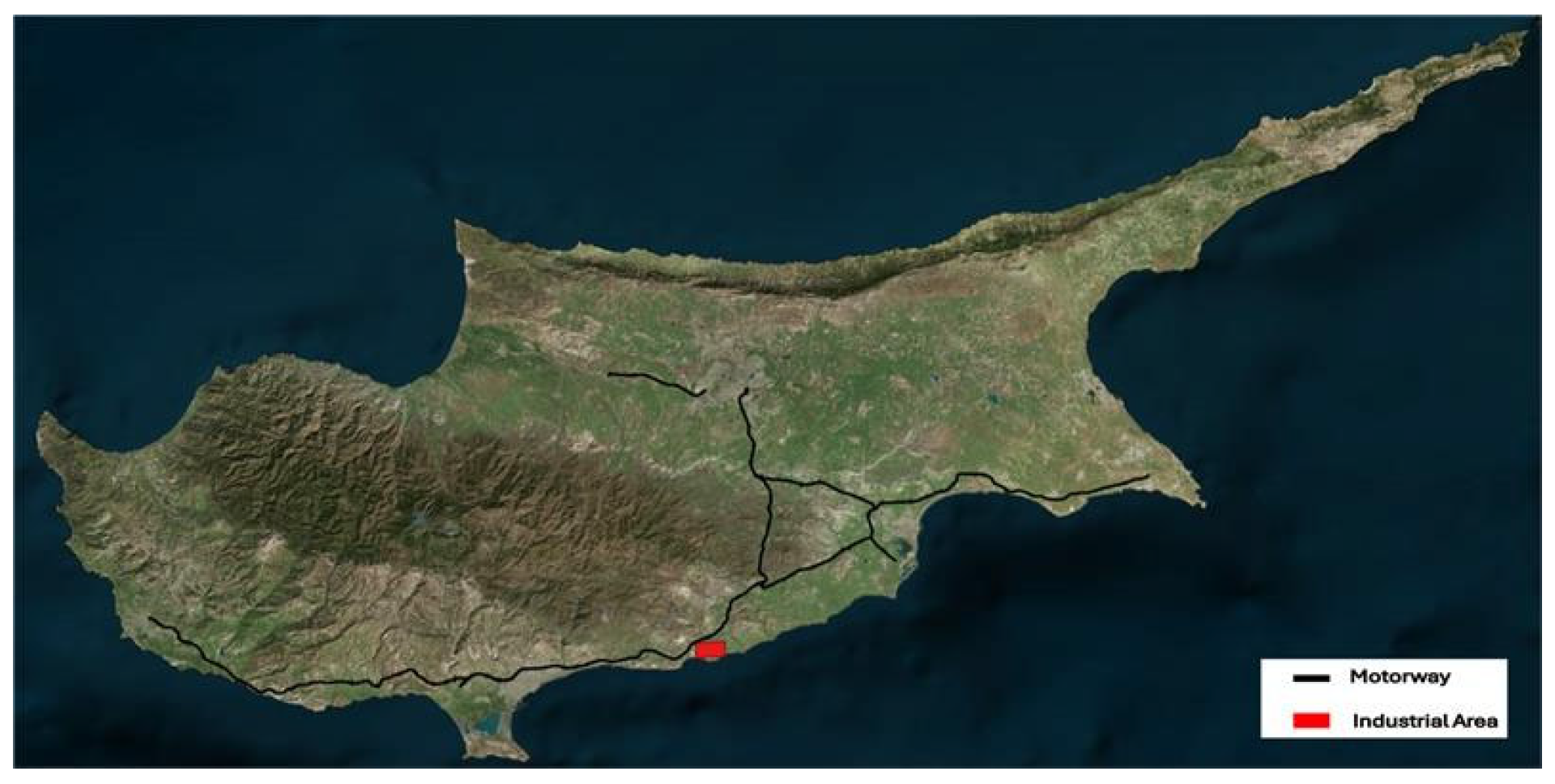
Figure 1 displays the study area. Black colored line illustrates the main motorways of Cyprus and red colored box represents the major industrial area. Air quality above Cyprus is mainly affected by the conventional electric power generation and road transportations in the island [12]. Moreover, air pollution from such economic activities had a negative effect in health on society [13]. Thus, in this study we executed the following two extreme scenarios towards cleaner energy production and road transportation:
  • Scenario 1: Assumption of 60% reduction in emissions from major combustion sources including public electric power and heat generation, petroleum refining and other energy industries, as well as commercial, institutional, military, and residential sectors.
  • Scenario 2: Assumption of 20% reduction in emissions from the road transport sector, covering both exhaust emissions from vehicle types and non-exhaust sources such as tire and brake wear.
Figure 1. Study area. Black colored line represents the main motorways of Cyprus and red colored box represents the main industrial area.
Eesp 35 00063 g001
The scenarios were designed to approximate ambitions set by the European Green Deal, the NEC Directive, and the Zero Pollution Action Plan. Scenario 1 reflects deep reductions in combustion emissions foreseen for 2030 targets, while Scenario 2 aligns with policies prioritizing NO2 reduction in transport-dominated areas. For the impact of these two scenarios, we focus on two main study sections, as shown in Figure 1. The first consists of the main motorways of the Republic of Cyprus which are used for daily movements by the society using private vehicles, public transportation, and commercial transportation. The second is the main industrial area of the Republic of Cyprus, where the main electric power station is located. Scenario 1 simulates the delta concentrations [7] of PM2.5 and PM10, and Scenario 2 the delta concentrations of NO2 over Cyprus as value and percentage differences.

4. Results

Figure 2, Figure 3 and Figure 4 present simulations of air pollutant reductions, specifically PM2.5, PM10, and NO2, across Cyprus. These simulations are based on two hypothetical emission reduction scenarios, utilizing the online SHERPA scenario analysis modeling tool.
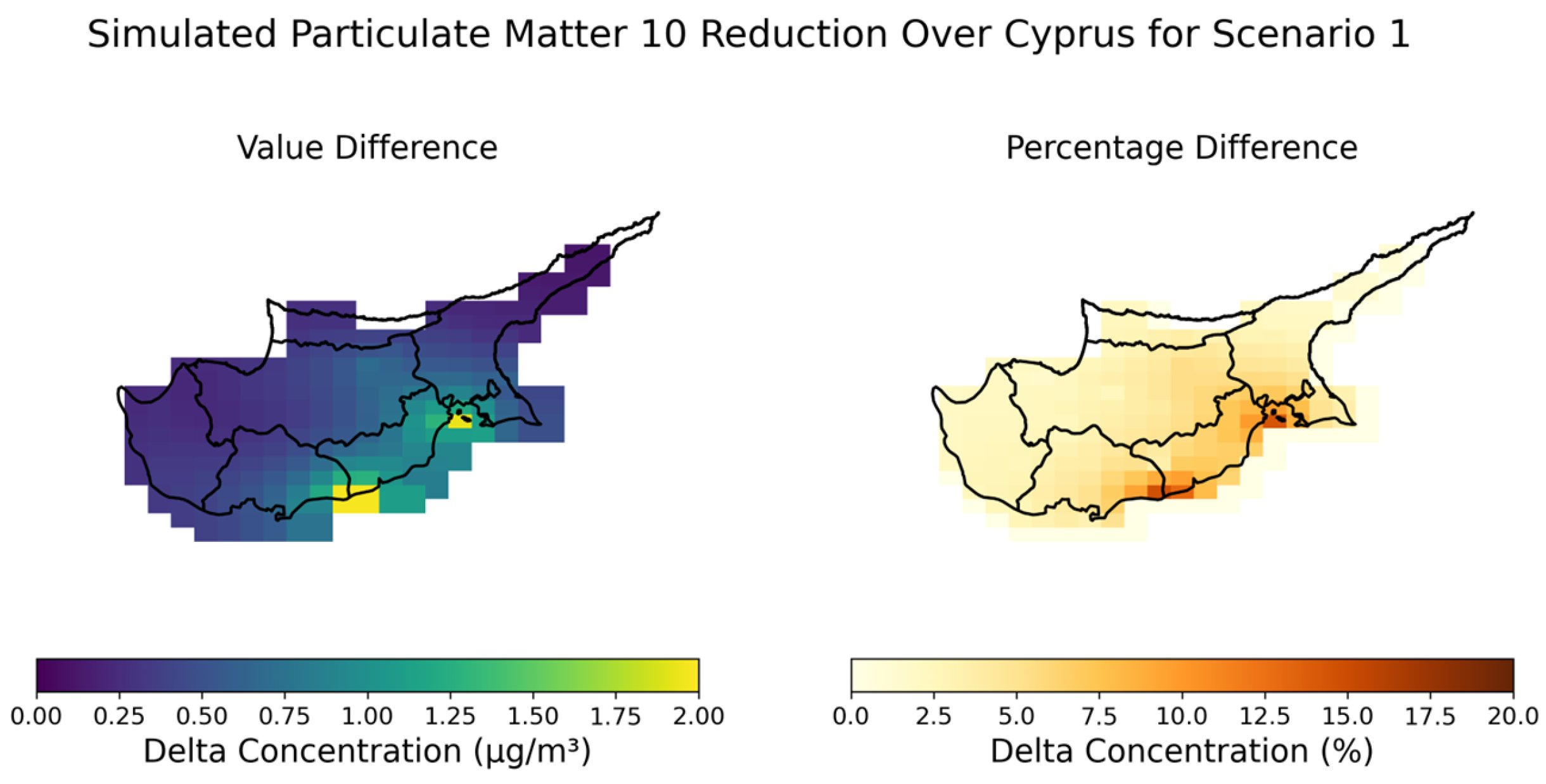
Scenario 1 describes a 60% reduction in emissions from major combustion sources, including public electricity and heat production, petroleum refining and other energy industries, as well as commercial, institutional, military, and residential sectors. These sources correspond to the GNFR_A, GNFR_B, and GNFR_C parameters(columns) in the SHERPA tool’s reduction table. Under this scenario, Figure 2 illustrates the resulting reduction in fine particulate matter (PM2.5), while Figure 3 depicts the reduction in coarse particulate matter (PM10).
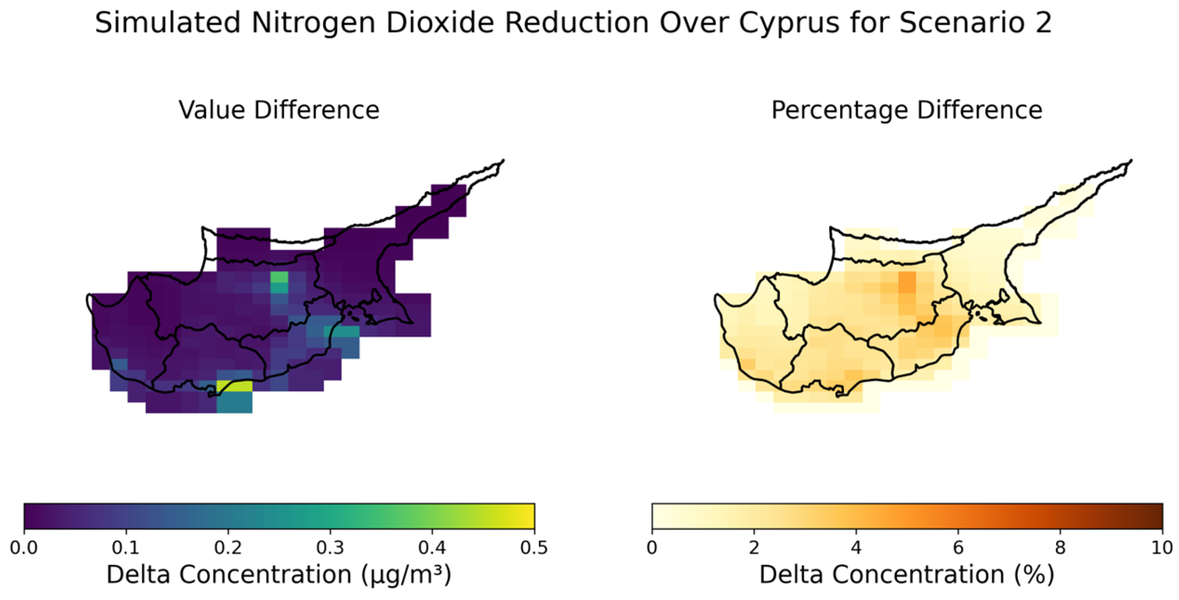
Scenario 2 illustrates a 20% reduction in emissions from the road transport sector, covering both exhaust emissions from all vehicle types and non-exhaust sources such as tire and brake wear. This source corresponds to GNFR_F parameter(column) in the SHERPA tool. The effect of this targeted intervention on NO2 concentrations is visualized in Figure 4. Each figure consists of two subplots: the left plot depicts the reduction value compared to the baseline in µg/m3, while the plot on the right side shows the rate of reduction in percentage. This dual representation offers both quantitative and proportional insight into air quality improvements under each scenario across Cyprus.

5. Discussion and Conclusions

The simulation results highlight the potential effectiveness of targeted emissions reduction strategies for improving air quality in Cyprus. Scenario 1, which addressed large combustion sources, resulted in substantial reduction in particulate matter concentrations along the southern coast of Cyprus, particularly near the Mari and Zygi industrial zones, as demonstrated in Figure 2 and Figure 3. This finding underscores the detrimental impact of energy production and industrial activities to particulate matter concentrations. Scenario 2 demonstrated that even a 20% reduction in road transport emissions can meaningfully decrease NO2 levels in densely populated zones and along the motorways in Cyprus, as illustrated in Figure 4. Although the improvements under both scenarios are not uniformly distributed across Cyprus, the results highlight those specific locations exhibited notable reductions in pollutants relevant to each respective scenario.
These findings underscore the value of using SHERPA as a screening tool to support policy development and scenario planning. By quantifying expected reductions in pollutant concentrations, SHERPA enhances air quality planning in Cyprus and informs policy decisions by assessing their potential contributions toward meeting future EU air quality targets.
Author Contributions

Conceptualization, J.B.R., S.P.N. and M.N.A.; methodology, S.P.N. and M.N.A.; software, J.B.R.; validation, S.P.N., M.N.A. and D.G.H.; formal analysis, J.B.R. and S.P.N.; investigation, M.N.A.; resources, J.B.R. and O.L.; data curation, J.B.R.; writing—original draft preparation, J.B.R., M.N.A., S.P.N. and O.L.; writing—review and editing, D.G.H. and S.M.; visualization, M.N.A.; supervision, S.M. and D.G.H.; project administration, D.G.H.; funding acquisition, D.G.H. All authors have read and agreed to the published version of the manuscript.

Funding

This research and APC were funded by ‘EXCELSIOR’ (European Union’s Horizon 2020 research and innovation programme), grant number “857510”.

Institutional Review Board Statement

Not applicable.

Informed Consent Statement

Not applicable.

Data Availability Statement

Data are available as pre-loaded component in Screening for High Emission Reduction Potential on Air (SHERPA) simulation tool (https://github.com/enricopisoni/SHERPA-simulation, accessed on 5 July 2025).

Acknowledgments

This work was partially supported by Copernicus Atmosphere Monitoring Service (CAMS) National Collaboration Programme under the “National Integration and Optimization of CAMS Products: A Collaborative Approach for Monitoring”, CAMS2_72CY_ECoE and the HORIZON European Research and Innovation Programme under the ‘EXCELSIOR’: ERATOSTHENES: Excellence Research Centre for Earth Surveillance and Space-Based Monitoring of the Environment H2020 Widespread Teaming project (www.excelsior2020.eu). The CAMS is one of six services of the Copernicus Programme and is implemented by the European Centre for Medium-Range Weather Forecasts (ECMWF) with funding from the European Commission. Copernicus is the Earth observation component of the European Union’s space programme. The ‘EXCELSIOR’ project has received funding from the European Union’s Horizon 2020 research and innovation programme under Grant Agreement No 857510, from the Government of the Republic of Cyprus through the Directorate General for the European Programmes, Coordination and Development and the Cyprus University of Technology.

Conflicts of Interest

The authors declare no conflicts of interest.

References

  1. Pope, C.; Dockery, D. Health Effects of Fine Particulate Air Pollution: Lines That Connect. J. Air Waster Manag. Assoc. 2006, 56, 709–742. [Google Scholar] [CrossRef] [PubMed]
  2. World Health Organization. WHO Global Air Quality Guidelines: Particulate Matter (PM2.5 and PM10), Ozone, Nitrogen Dioxide, Sulfur Dioxide, and Carbon Monoxide; World Health Organization: Geneva, Switzerland, 2021. [Google Scholar]
  3. Air Quality in Europe 2022. Available online: https://www.eea.europa.eu/publications/air-quality-in-europe-2022 (accessed on 10 July 2025).
  4. Querol, X.; Alastuey, A.; Moreno, T.; Viana, M.; Castillo, S.; Pey, J.; Rodríguez, S.; Artíñano, B.; Salvador, P.; Sánchez, M.; et al. Spatial and Temporal Variations in Airborne Particulate Matter (PM10 and PM2.5) across Spain 1999–2005. Atmos. Environ. 2008, 42, 3964–3979. [Google Scholar] [CrossRef]
  5. Vrekoussis, M.; Richter, A.; Hilboll, A.; Burrows, J.P.; Gerasopoulos, E.; Lelieveld, J.; Barrie, L.; Zerefos, C.; Mihalopoulos, N. Economic Crisis Detected from Space: Air Quality Observations over Athens/Greece. Geophys. Res. Lett. 2013, 40, 458–463. [Google Scholar] [CrossRef]
  6. Thunis, P.; Degraeuwe, B.; Pisoni, E.; Ferrari, F.; Clappier, A. On the Design and Assessment of Regional Air Quality Plans: The SHERPA Approach. J Environ. Manag. 2016, 183, 952–958. [Google Scholar] [CrossRef] [PubMed]
  7. Peduzzi, E.; Pisoni, E.; Clappier, A.; Thunis, P. Multi-Level Policies for Air Quality: Implications of National and Sub-National Emission Reductions on Population Exposure. Air Qual. Atmos. Health 2018, 11, 1121–1135. [Google Scholar] [CrossRef] [PubMed]
  8. Pisoni, E.; Albrecht, D.; Mara, T.A.; Rosati, R.; Tarantola, S.; Thunis, P. Application of Uncertainty and Sensitivity Analysis to the Air Quality SHERPA Modelling Tool. Atmos. Environ. 2018, 183, 84–93. [Google Scholar] [CrossRef]
  9. Sartini, L.; Antonelli, M.; Pisoni, E.; Thunis, P. From Emissions to Source Allocation: Synergies and Trade-Offs between Top-down and Bottom-up Information. Atmos. Environ. X 2020, 7, 100088. [Google Scholar] [CrossRef]
  10. Degraeuwe, B.; Pisoni, E.; Christidis, P.; Christodoulou, A.; Thunis, P. SHERPA-City: A Web Application to Assess the Impact of Traffic Measures on NO2 Pollution in Cities. Environ. Model. Softw. 2021, 135, 104904. [Google Scholar] [CrossRef] [PubMed]
  11. Pisoni, E.; De Marchi, D.; di Taranto, A.; Bessagnet, B.; Sajani, S.Z.; De Meij, A.; Thunis, P. SHERPA-Cloud: An Open-Source Online Model to Simulate Air Quality Management Policies in Europe. Environ. Model. Softw. 2024, 176, 106031. [Google Scholar] [CrossRef]
  12. Tsilingiridis, G.; Sidiropoulos, C.; Pentaliotis, A.; Evripidou, C.; Papastavros, C.; Mesimeris, T.; Papastavrou, M. A Spatially Allocated Emissions Inventory for Cyprus. Glob. NEST J. 2010, 12, 99–107. [Google Scholar] [CrossRef]
  13. Giannakis, E.; Serghides, D.; Dimitriou, S.; Zittis, G. Land Transport CO 2 Emissions and Climate Change: Evidence from Cyprus. Int. J. Sustain. Energy 2020, 39, 634–647. [Google Scholar] [CrossRef]
Figure 2. Spatial distribution of reduction in PM2.5, resulting from Scenario 1. Left and right subplots illustrate delta concentrations as value and percentage differences, respectively.
Eesp 35 00063 g002
Figure 3. Spatial distribution of reduction in PM10, resulting from Scenario 1. Left and right subplots illustrate delta concentrations as value and percentage differences, respectively.
Eesp 35 00063 g003
Figure 4. Spatial distribution of reduction in NO2, resulting from Scenario 2. Left and right subplots illustrate delta concentrations as value and percentage differences, respectively.
Eesp 35 00063 g004
Disclaimer/Publisher’s Note: The statements, opinions and data contained in all publications are solely those of the individual author(s) and contributor(s) and not of MDPI and/or the editor(s). MDPI and/or the editor(s) disclaim responsibility for any injury to people or property resulting from any ideas, methods, instructions or products referred to in the content.