Proceeding Paper

First Results of Strategic Infrastructure Project CYGMEN: Cyprus GNSS Meteorology Enhancement †

by
Christina Oikonomou
1,2,*,
Haris Haralambous
1,3,
Despina Giannadaki
2,
Filippos Tymvios
4,
Demetris Charalambous
4,
Vassiliki Kotroni
5,
Konstantinos Lagouvardos
5 and
Eleftherios Loizou
6
1
Frederick Research Center, Nicosia 1036, Cyprus
2
Cloudwater Ltd., Nicosia 1026, Cyprus
3
Department of Electrical Engineering, Computer Engineering and Informatics, Frederick University, Nicosia 1036, Cyprus
4
Department of Meteorology, Nicosia 1036, Cyprus
5
National Observatory of Athens, 11810 Athens, Greece
6
Nicosia Development Agency, Nicosia 2253, Cyprus
*
Author to whom correspondence should be addressed.
Presented at the 17th International Conference on Meteorology, Climatology, and Atmospheric Physics—COMECAP 2025, Nicosia, Cyprus, 29 September–1 October 2025.
Environ. Earth Sci. Proc. 2025, 35(1), 35; https://doi.org/10.3390/eesp2025035035
Published: 16 September 2025

Abstract

The CYGMEN (Cyprus GNSS Meteorology Enhancement) infrastructure project aims to establish a meteorological cluster (CyMETEO) in Cyprus of a lightning detection network, a dense GNSS (Global Navigation Satellite System) network for atmospheric water vapor estimation, a Radar Wind Profiler, and a microwave radiometer. Additionally, observational data generated by CyMETEO infrastructure will be assimilated into the Weather Research and Forecasting (WRF) model with the aim of improving short-term weather forecasting. The preliminary results of precipitable water vapor (PWV) estimation by employing (a) a GNSS network, (b) a microwave radiometer, (c) radiosonde, and (d) ERA5 reanalysis datasets over the Athalassas super-site in Nicosia, during May 2025, are intercompared in this study.

1. Introduction

The Eastern Mediterranean and Middle East region has been identified as a major climate change hotspot mainly due to changes in the mean climate conditions leading to a combination of extreme weather events, including long drought periods, extreme temperatures, and extreme and abrupt rainfall [1,2]. Precipitable water vapor (PWV), which is the total amount of water vertically integrated in the atmospheric column over an area, is an important indicator of the potential for heavy rainfall and is a valuable parameter for near-real-time extreme weather forecasting. Accurate estimation of PWV can significantly improve numerical weather prediction (NWP) models and short-range weather forecasting and nowcasting [3,4]. Several methods have been developed to estimate PWV, with radiosonde measurements, remote sensing techniques, microwave radiometers (MWRs), and GNSS (Global Navigation Satellite System) observations being among the most widely used. Radiosonde is the primary in situ measurement to obtain PWV from detailed vertical profiles with high accuracy and is commonly used as a reference for the validation of other methods. However, it faces various biases and instability in severe weather conditions (e.g., thunderstorms). It has low spatial resolution, significant temporal inhomogeneity, and a very high cost. Thus, it cannot cover the needs of monitoring and forecasting extreme weather phenomena [5]. Microwave radiometers provide continuous, ground-based measurements with larger spatial coverage and are relatively cheaper and more convenient to deploy. One significant limitation, though, is that MWR-derived PWV and water vapor profiles are becoming unreliable during moderate and heavy precipitation events due to contamination of rainwater on the sensor covering the instrument [6]. GNSS ground-based PWV is a reliable technique to estimate PWV by exploiting the propagation delay of the GNSS satellite signals caused by the dry and wet components of the troposphere. It is a widely used method for the last 20 years with proven advantages of high accuracy, high temporal and spatial resolution, long-term stability, and lower cost compared to the traditional methods of radiosonde and MWRs. Zhang et al. [7], Vaquero-Martínez et al. [8], and Zhao et al. [9] confirm the robustness of ground-based GNSS-derived PWV against radiosonde and ECMWF data. Numerous studies have used the GNSS-PWV measurements as a reference for comparison purposes with other methods. Renju et al. [6] performed a comparison of PWV estimated from an MWR against PWV estimated from GPS signals in a tropical region, yielding a correlation coefficient of 0.98 and an RMS difference of 1.6 mm in all seasons. Hu et al. [10] also found that the PWV values retrieved from the MWR were positively correlated with those from GNSS ground stations, radiosonde, and ECMWF reanalysis. They found, though, that the MWR overestimates PWV values under rain conditions. In a more recent study by Vaquero-Martínez et al. [11], PWV data recorded from MWRs and sun photometers show a very good agreement against reference GNSS PWV data in the Portuguese and Spanish stations analyzed, with a high correlation coefficient (0.94–0.98) in all cases and a standard deviation below 1.5 mm. They also point out the reduced quality of MWR products under rainfall conditions.
In Cyprus, extreme temperatures and abrupt and heavy rain events are expected to become more frequent [2]. In particular, coastal areas around the eastern Mediterranean Sea have been very frequently subjected to severe convective storms during the last 10 years. “Medicanes”, hurricane-like cyclonic systems in the Mediterranean Sea, are becoming an increasingly severe problem for many countries, causing loss of lives and extensive damage. There is a clear demand to combine meteorological data from different sources, such as satellites, weather radar, wind profilers, and radiometers, into weather prediction models in order to synthesize a more comprehensive picture of these fast-developing intense storms over the EM region. The assimilation of space and ground-based data into weather prediction models/services, such as near-real-time GNSS-derived PWV data, comprises a significant step forward to improve short-term forecasting of rapid convective storms and heavy precipitation events.
In this regard, the CYGMEN infrastructure project, which is a collaboration οf the Frederick Research Center and the Cyprus Department of Meteorology (DoM), aspires to produce heterogeneous weather observations for the purpose of (a) improving operational weather forecasting (with a focus on precipitation and convection) by the Cyprus DoM and (b) enhancing research activities in the field of meteorology, weather prediction, and atmospheric physics. The objective of the present investigation is to intercompare initial PWV observations deriving from CyMETEO instruments (GNSS receiver and microwave radiometer), the radiosonde station of the DoM, and ERA5 reanalysis data during two rainy events of May 2025.

2. Materials and Methods

Athalassas Radiosonde Station. The radiosonde station of the Cyprus DoM is located in Athalassa (35.127° N, 33.392° E) in Nicosia province. The station provides upper air measurements (also called soundings or radio-soundings), which make use of special equipment known as sondes or radiosondes. These devices are equipped with meteorological sensors for measuring atmospheric temperature, humidity, and pressure, as well as a GPS sensor. The end product of the sounding is the determination of a thermodynamic profile of the atmosphere from the surface to the stratosphere. The radiosonde measurements provide valuable information for the numerical weather prediction models used for weather forecasting. Soundings at Athalassa take place twice per day, at 06 and 12 UTC.
Microwave radiometer (MWR). In addition to in situ measurements from the radiosonde station, a 14-channel HATPRO (Humidity And Temperature PROfiler) microwave radiometer (MWR) was recently installed (March 2025) as part of the CyMETEO network infrastructure in Athalassa station in the framework of the CYGMEN project. The HATPRO MWR is a passive instrument with two frequency reception bands of 22.24–31.4 GHz to retrieve humidity profiles, precipitable water vapor (PWV), and liquid water path (LWP) and 51–58 GHz to retrieve temperature profiles.
GNSS ground-based measurements. The CyMETEO-GNSS network has installed 13 GNSS receivers in close vicinity to meteorological stations operated by the Cyprus DoM. Raw GNSS data from all available operational GNSSs (GPS, GALILEO, GLONASS, and BeiDou) are processed to estimate the near-real-time (15 min time resolution) PWV by exploiting the zenith tropospheric delay (ZTD) of GNSS satellite signals. Bevis et al. [12] introduced this method, mathematically described by Equations (1)–(3), where the ZWD and the ZHD are the zenith delay caused by the wet and dry components of the troposphere, respectively, as shown in the following equations:
PWV = Π × ZWD,
ZWD = ZTD × ZHD,
Π = 1 0 6   ρ R u ( k 3 T m + k 2 ) 1
where k2 = k2 − mk1, k1 = 77.604 K/hPa, k2 = 17 K/hPa, and k3 = 3.776 × 10⁵ K/hPa, ρ = 1025, kg m−3 is the density of liquid water, Ru = 461.51, J K−1kg−1 is the specific gas constant of water vapor, Tm is the water vapor weighted mean temperature of the atmosphere as defined by Davis et al. (1985) [13], and m is the ratio of the molar mass of water vapor and dry air. The weighted mean temperature Tm is derived from Equation (4), which holds for mid-latitudes as follows:
Tm = 50.4 + 0.789Ts
where Ts is the surface temperature in Kelvin. k1, k2, and k3 are the atmospheric refractivity constants. The largest source of error in calculating PWV from Equations (1) and (2) comes from uncertainties in the weighted mean temperature Tm and in the physical constants k1, k2, and k3. The ZHD is estimated by the following formula:
ZHD P , Φ , h = 0.0022768 P 1 0.00266 cos ( 2 Φ ) 0.00028 h
where P is the atmospheric pressure, Φ is the station latitude, and h the station’s orthometric height. For this study, the essential parameters Tm and P were obtained from the GPT2w blind empirical model.
The preliminary results of PWV monitoring over Athalassas station during 2 rain events in May 2025, as obtained from the radiosonde, the MWR, and the GNSS operation of CyMETEO, will be presented in the next section. For the intercomparison of PWV products, hourly ECMWF-ERA5 reanalysis PWV data are also used (5th generation of the European Centre for Medium-Range Weather Forecasts (ECMWF)), as they have been compared with in situ observations and show high accuracy and reliability in PWV estimations. Figure 1 shows the infrastructure used for the atmospheric water vapor monitoring, including the HATPRO MWR in the Athalassas station and the GNSS network (red dots) of the Frederick Research Center FRC-CyMETEO cluster and the radiosonde instrument of the Department of Meteorology.

3. Results

The estimations of PWV over Athalassa station in Nicosia derived from the GNSS receiver (near-real-time), the HATPRO MWR (continuous), the radiosonde (point values), and the ERA5 (hourly) together with the 10 min rain from the Cyprus DoM during 1–4 May (event 1), and 13–14 May 2025 (event 2) are presented in Figure 2. For event 2, there are no PWV data from the MWR, as the instrument was out of order. The time series analysis shows that the GNSS-PWV values have great similarity with the radiosonde point values and follow a very similar time evolution pattern to the ERA5-PWV with comparable values. The MWR-PWV shows excellent comparison with the GNSS-PWV before and after rain, while during the rainfall time, it significantly overestimates PWV, which is a well-known constraint for the performance of the MWR. During event 2, with 14 May being a day with heavy rainfall (accumulated rain at 20 mm), GNSS-PWV shows comparable performance with the radiosonde data, while compared to ERA5-PWV estimations, although they follow a similar pattern for most of the period before rain, GNSS-PWV takes lower values most of the time. Finally, for both events, PWV has an increasing trend before the rain starts, reaching a peak value during rainfall, followed by a decreasing trend after peak rainfall (except the ERA5-PWV in event 2 reaching a peak 1 h before the onset of rain).

4. Discussion and Conclusions

The first results of PWV monitoring over Athalassa station show a good comparison between the GNSS, MWR, radiosonde, and ERA5-derived PWV, especially during event 1, following a very similar time evolution pattern, with the exception of MWR-PWV during the time of rainfall on 4 May. The MWR-PWV values are too large when there is rainfall. This outcome is in agreement with other studies that also find that MWR-PWV is well intercompared with PWV derived from GNSS, radiosonde, and ECMWF reanalysis, but MWR measurements are often overestimated during rain [6,10,11]. Raindrops can attenuate and scatter the microwave radiation, impacting the accuracy of PWV retrievals. Moreover, water accumulation on the MWR radome can further impair measurements. The strong microwave signal from rain droplets can overwhelm the weaker signal from water vapor, which can explain the overestimation of MWR-PWV during rain, with larger raindrops having a more significant impact on MWR performance [14].
Finally, the concurrent time series of PWV and rain for the two events shows an increasing trend in GNSS-PWV before rainfall starts, with a peak value during the time of rain peak, followed by a decline, which is in agreement with the findings of recent studies investigating the PWV–rain relationship. These preliminary results are encouraging for the prospects of densely and highly accurate PWV monitoring, which will be used to investigate extreme precipitation events and improve short-range weather forecasting in Cyprus.

Author Contributions

Conceptualization, C.O. and F.T.; methodology, H.H. and C.O.; software, D.C. and H.H.; validation, D.G. and C.O.; data curation, D.C.; writing—original draft preparation, D.G. and C.O.; writing—review and editing, D.G., C.O., H.H., V.K., K.L. and E.L.; supervision, H.H. and C.O.; project administration, C.O. and D.G. All authors have read and agreed to the published version of the manuscript.

Funding

This study is conducted in the framework of the Strategic Infrastructure project CYPRUS GNSS METEOROLOGY ENHANCEMENT (CYGMEN, Proposal No. STRATEGIC INFRASTRUCTURES/1222/0198), which is implemented in the framework of the Cohesion Policy Programme “THALIA 2021–2027” and is co-funded by the European Union.

Institutional Review Board Statement

Not applicable.

Informed Consent Statement

Not applicable.

Data Availability Statement

All CyMETEO data are available from the authors upon request.

Acknowledgments

The authors acknowledge the Cyprus Dept. of Meteorology for radiosonde rainfall data provision.

Conflicts of Interest

Despina Giannadaki was employed by Cloudwater Ltd. and declares that the research was conducted in the absence of any commercial or financial relationships that could be construed as a potential conflict of interest”.

References

  1. Lelieveld, J.; Hadjinicolaou, P.; Kostopoulou, E.; Chenoweth, J.; El Maayar, M.; Giannakopoulos, C.; Hannides, C.; Lange, M.A.; Tanarhte, M.; Tyrlis, E.; et al. Climate change and impacts inthe Eastern Mediterranean and the Middle East. Clim. Change 2012, 114, 667–687. [Google Scholar] [CrossRef] [PubMed]
  2. Zittis, G.; Almazroui, M.; Alpert, P.; Ciais, P.; Cramer, W.; Dahdal, Y.; Fnais, M.; Francis, D.; Hadjinicolaou, P.; Howari, F.; et al. Climate change and weather extremes in the Eastern Mediterranean and Middle East. Rev. Geophys. 2022, 60, e2021RG000762. [Google Scholar] [CrossRef]
  3. Mazzarella, V.; Milelli, M.; Lagasio, M.; Federico, S.; Torcasio, R.C.; Biondi, R.; Realini, E.; Llasat, M.C.; Rigo, T.; Esbrí, L.; et al. Is an NWP-Based Nowcasting System Suitable for Aviation Operations? Remote Sens. 2022, 14, 4440. [Google Scholar] [CrossRef]
  4. Zhang, Z.; Lou, Y.; Zhang, W.; Liang, H.; Bai, J.; Song, W. Correlation Analysis between Precipitation and Precipitable Water Vapor over China Based on 1999–2015 Ground-Based GPS Observations. J. Appl. Meteorol. Climatol. 2022, 61, 1669–1683. [Google Scholar] [CrossRef]
  5. Huang, L.; Mo, Z.; Xie, S.; Liu, L.; Chen, J.; Kang, C.; Wang, S. Spatiotemporal characteristics of GNSS-derived precipitable water vapor during heavy rainfall events in Guilin, China. Satell Navig. 2021, 2, 13. [Google Scholar] [CrossRef]
  6. Renju, R.; Raju, C.S.; Mathew, N.; Antony, T.; Moorthy, K.K. Microwave radiometer observations of interannual water vapor variability and vertical structure over a tropical station. J. Geophys. Res. Atmos. 2015, 120, 4585–4599. [Google Scholar] [CrossRef]
  7. Zhang, Q.; Ye, J.; Zhang, S.; Han, F. Precipitable Water Vapor Retrieval and Analysis by Multiple Data Sources: Ground-Based GNSS, Radio Occultation, Radiosonde, Microwave Satellite, and NWP Reanalysis Data. J. Sens. 2018, 2018, 3428303. [Google Scholar] [CrossRef]
  8. Vaquero-Martínez, J.; Antón, M.; Ortiz de Galisteo, J.P.; Román, R.; Cachorro, V.E.; Mateos, D. Comparison of integrated water vapor from GNSS and radiosounding at four GRUAN stations. Sci. Total Environ. 2019, 648, 1639–1648. [Google Scholar] [CrossRef] [PubMed]
  9. Zhao, Q.; Yao, Y.; Yao, W.; Zhang, S. GNSS-derived PWV and comparison with radiosonde and ECMWF ERA-Interim data over mainland China. J. Atmos. Sol.-Terr. Phys. 2019, 182, 85–92. [Google Scholar] [CrossRef]
  10. Hu, H.; Yang, R.; Lee, W.; Cao, Y.; Mao, J.; Gao, L. Multi-sensor study of precipitable water vapor and atmospheric profiling from microwave radiometer, GNSS/MET, radiosonde, and ECMWF reanalysis in Beijing. J. Appl. Remote Sens. 2020, 14, 044514. [Google Scholar] [CrossRef]
  11. Vaquero-Martínez, J.; Antón, M.; Costa, M.; Bortoli, D.; Navas-Guzmán, F.; Alados-Arboledas, L. Microwave radiometer, sun-photometer and GNSS multi-comparison of integrated water vapor in Southwestern Europe. Atmos. Res. 2023, 287, 106698. [Google Scholar] [CrossRef]
  12. Bevis, M.; Businger, S.; Chiswell, S.; Herring, T.A.; Anthes, R.; Rocken, C.; Ware, R.H. GPS Meteorology: Mapping Zenith Wet Delays onto Precipitable Water. J. Appl. Meteorol. 1994, 33, 379–386. [Google Scholar] [CrossRef]
  13. Davis, J.L.; Herring, T.A.; Shapiro, I.I.; Rogers, A.E.E.; Elgered, G. Geodesy by radio interferometry: Effects of atmospheric modelling errors on estimates of baseline length. Radio. Sci. 1985, 20, 1593–1607. [Google Scholar] [CrossRef]
  14. Foth, A.; Lochmann, M.; Saavedra Garfias, P.; Kalesse-Los, H. Determination of low-level temperature profiles from microwave radiometer observations during rain. Atmos. Meas. Tech. 2024, 17, 7169–7181. [Google Scholar] [CrossRef]
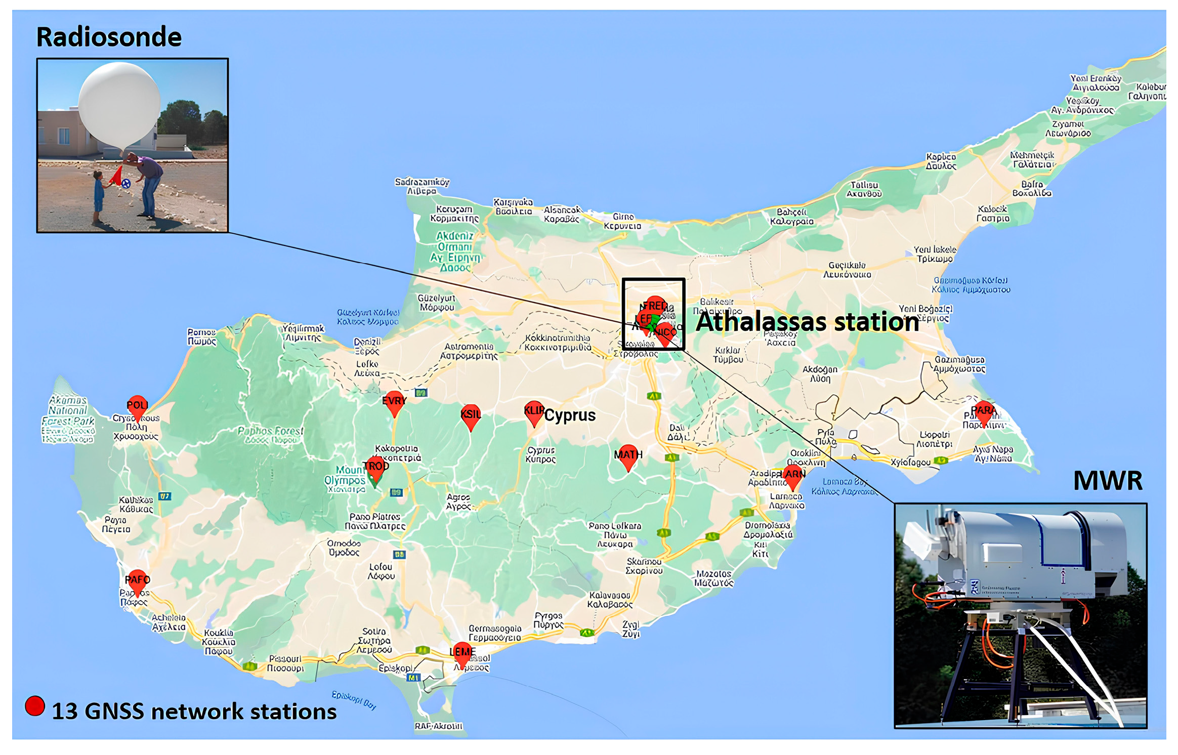
Figure 1. Infrastructure used for atmospheric water vapor estimation over Athalassas station in the framework of the CYGMEN project: GNSS network (red dots) and microwave radiometer (MWR) of the Frederick Research Center FRC-CyMETEO cluster and radiosonde instrument of the Department of Meteorology.
Eesp 35 00035 g001
Figure 2. Estimations of PWV from the GNSS receiver, MWR, radiosonde (RD), and ERA5 and rain measurements from the Cyprus DoM during 1–4 May and 13–14 May 2025 (MWR-PWV not available) over Athalassa station.
Eesp 35 00035 g002
Disclaimer/Publisher’s Note: The statements, opinions and data contained in all publications are solely those of the individual author(s) and contributor(s) and not of MDPI and/or the editor(s). MDPI and/or the editor(s) disclaim responsibility for any injury to people or property resulting from any ideas, methods, instructions or products referred to in the content.