Abstract
On 31 March 2025, a severe thunderstorm system affected the Cyclades region, causing extensive flash floods on the islands of Paros and Mykonos and leading to significant material damage. This study investigates the meteorological characteristics of the event and focuses on the potential role of elevated sea surface temperatures (SSTs) in intensifying the storm’s severity. The analysis is centered on the broader Aegean region (geographic extent: 41.25° N, 21.83° E to 34.30° N, 28.51° E), utilizing ERA5 reanalysis data from ECMWF. These data provide high-resolution information on the atmospheric and ocean surface conditions during the event. The primary research objective is to explore how warmer SSTs may have contributed to enhanced moisture in the lower troposphere and increased energy availability for convective storm development. The theoretical background and a preliminary data exploration suggest that elevated SSTs likely favored increased evaporation, enhanced low-level moisture transport, and greater atmospheric instability, leading to the development of deep convective clouds. This, in turn, may have intensified precipitation rates and elevated the flood risk. This study aims to contribute to a better understanding of the mechanisms behind such extreme weather events, particularly in island environments, and to explore the sea’s potential catalytic role under a changing climate.
1. Introduction
Recent studies have highlighted the significant influence of sea surface temperature (SST) on high-impact weather events [1]. Sea surface temperature is a fundamental boundary condition in the modulation of atmospheric processes over oceanic and semi-enclosed basin environments. In the mid-latitudes, SST anomalies and horizontal SST gradients have been shown to significantly influence surface heat fluxes, the lower-tropospheric moisture content, and static stability, thereby affecting the development and intensification of synoptic and mesoscale systems [2]. Numerous studies [3,4,5] have established a positive association between elevated SST values and the deepening rates of cyclonic systems, particularly under baroclinic conditions. Recent research focusing on the Mediterranean has highlighted the role of sea surface temperature gradients in enhancing convective intensity and precipitation, emphasizing the thermodynamic destabilization that they induce in the lower troposphere [6].
An elevated sea surface temperature increases the magnitude of latent and sensible heat fluxes, which, under favorable synoptic forcing, may serve as a preconditioning mechanism for the onset of intense convective systems. Observational and modeling studies have further demonstrated that severe convective events tend to coincide with regions of enhanced sea surface temperature gradients rather than with peak sea surface temperature values alone, underscoring the dynamical importance of the horizontal thermal structure [7,8].
On 31 March 2025, a severe convective system affected the Cyclades region of the central Aegean Sea, producing intense rainfall and flash flooding, particularly on the islands of Paros and Mykonos. The objectives of the present study are to determine whether a warm SST anomaly was present during the event and to assess the extent to which it influenced the thermodynamic and dynamic conditions that favored the development and intensification of the convective system. Specifically, this study investigates the extent to which SST-induced surface fluxes enhanced low-level moisture and destabilized the atmospheric column, thereby influencing convective intensity and precipitation rates. To quantify the degree of atmospheric instability, the convective available potential energy (CAPE) index is employed as a diagnostic tool, providing insights into the vertical thermodynamic structure and potential for deep convection during the event.
2. Data and Methodology
The analysis utilizes high-resolution ERA5 reanalysis data from the European Centre for Medium-Range Weather Forecasts (ECMWF), focusing on the geographic domain encompassing the broader Aegean basin. ERA5 represents the most recent reanalysis dataset from ECMWF, featuring a regular latitude–longitude grid, with a spatial resolution of 0.5° × 0.5°. By examining both the temporal evolution and spatial distribution of sea surface temperatures (SSTs) and associated surface fluxes, this study aims to elucidate the coupling between oceanic thermal conditions and mesoscale atmospheric processes during this high-impact weather event. The findings contribute to a better understanding of air–sea interactions in the Mediterranean and support improved forecasting capabilities for convective hazards in maritime environments under a warming climate regime.
3. Results
This study focuses on a storm that affected parts of Greece—specifically the Cyclades—with extreme rainfall and unprecedented widespread flooding on 31 March 2025. The highest daily rainfall was recorded at the automatic weather station operated by the National Observatory of Athens/meteo.gr, located on the island of Mykonos (Elev: 10 m, 37.4° N, 25.3° E), reaching 71.6 mm. Notably, 65 mm of this total fell within just two hours, between 17:10 and 19:10 local time on Monday, March 31.
The synoptic conditions in the upper troposphere on that day are of particular interest, as an Omega-type blocking anticyclone had settled over the European region, shifting the atmospheric circulation pattern from zonal to meridional (Figure 1). In this configuration, the anticyclone is flanked by two low-pressure systems—one upstream and one downstream. Over the Greek region, a deep mid-tropospheric low was present, as seen in the 500 hPa chart at 18 UTC, accompanied by cold air masses with temperatures around –23 °C.
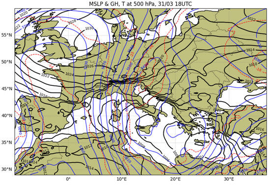
Figure 1.
Sea level pressure (continuous black lines, in hPa), distribution of geopotential heights (continuous blue lines, in gpm), and temperature (dashed red lines, in °C) on the 500 hPa isobaric surface at 18 UTC on March 31.
On the surface, a low-pressure system with a central pressure of 1000 hPa moved slowly from the southwest to the northeast, following the path of a branch of the polar jet stream, which was associated with the broader cyclonic disturbance. The presence of the polar jet enhanced the intensity of the phenomena by injecting turbulent kinetic energy into the upper tropospheric flow, which was converted into available potential energy [9], thereby supporting the deepening of the disturbance.
In addition to the dynamic processes in the upper troposphere, the diabatic conditions in the lower troposphere also played a crucial role in the intensity of the event. Surface latent and sensible heat fluxes from the warmer Aegean Sea (Figure 2) enhanced the thermal potential of the region, enriching the atmosphere with moisture and energy. The upward transport of this warm and moist air, combined with the intrusion of cold air in the mid-troposphere, created strong thermodynamic forcing, enhancing upward motion and leading to the organization of deep convective cloud development by midday.
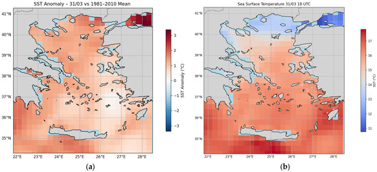
Figure 2.
(a) Sea surface temperature (SST) anomaly on 31 March 2025 relative to the 1981–2010 climatological mean, showing positive deviations of up to +1.5 °C, over the central and southern Aegean. (b) Absolute sea surface temperature (°C) at 18 UTC on 31 March 2025, highlighting warm SSTs (17–18 °C) over the southern Aegean that contributed to enhanced atmospheric instability during the convective event.
In the central and southern Aegean, a positive sea surface temperature (SST) anomaly of about 1 to 1.5 °C was observed compared to the 1981–2010 reference period (Figure 2a). According to [10] [X1] and [11] [X2], such anomalies are considered significant and sufficient to enhance vertical cloud development. Therefore, the storm that impacted the Cyclades developed in an environment that was particularly favorable for deep atmospheric instability, driven by the ascent of warm, moist air masses over warm sea surfaces with temperatures of 17–18 °C (Figure 2b).
This temperature contrast between the surface and the mid-troposphere significantly strengthened the positive vertical temperature gradient, resulting in increased values of convective available potential energy (CAPE), which favored the formation of deep convective clouds. CAPE quantifies thermodynamic instability by combining the temperature lapse rate and moisture content, while vertical wind shear promotes convective organization [12,13]. Prior to and during the storm event, CAPE values reached up to 1500 J/kg, indicating highly unstable conditions (Figure 3), while after 22:00 UTC, these values weakened significantly.
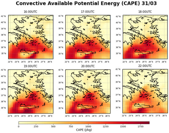
Figure 3.
Hourly evolution of convective available potential energy (CAPE, in J/kg) over Greece and the Aegean on 31 March 2025 from 16:00 to 22:00 UTC. CAPE values peak between 17:00 and 20:00 UTC over the central and southern Aegean, reaching up to 1500 J/kg, indicating a highly unstable atmospheric environment that is conducive to deep convective development. After 22:00 UTC, CAPE values decline significantly, suggesting stabilization of the atmosphere following the main convective activity.
The coexistence of positive surface thermal anomalies, intense upper-tropospheric cooling, and surface convergence along the low-pressure system acted as a key mechanism triggering the storm, resulting in locally severe weather phenomena across the Cyclades during the midday and afternoon hours of March 31.
4. Conclusions
This study analyzed a severe thunderstorm event that affected the Cyclades on 31 March 2025, causing destructive flash floods, particularly on Paros and Mykonos. The findings indicate that warm sea surface temperature (SST) anomalies, ranging from +1 to +1.5 °C, played a crucial role in intensifying the storm. The warm waters of the Aegean Sea enhanced latent and sensible heat fluxes toward the atmosphere, increasing low-level moisture and promoting strong thermodynamic instability. Simultaneously, the intrusion of cold air masses in the mid-troposphere reinforced the vertical temperature gradient, leading to high CAPE values of up to 1500 J/kg, which favored the development of deep convective clouds. Surface convergence, enhanced upper-tropospheric dynamics (linked to the polar jet stream), and an accompanying low-pressure system acted as key triggering mechanisms. Overall, the coexistence of positive SST anomalies, upper-level cooling, and dynamic forcing created an environment that was highly conducive to severe convection. This study highlights the catalytic role of elevated SSTs in amplifying extreme weather events, underscoring the importance of ocean thermal conditions in forecasting convective hazards in island and coastal regions.
Author Contributions
Conceptualization, S.T.A. and T.H.K.; methodology, S.T.A. and T.H.K.; software, S.T.A.; validation, T.H.K.; formal analysis, S.T.A.; investigation, S.T.A. and T.H.K.; resources, T.H.K. and S.T.A.; data curation, S.T.A.; writing—original draft preparation, S.T.A.; writing—review and editing, S.T.A. and T.H.K.; visualization, S.T.A. and T.H.K.; supervision, T.H.K. and S.T.A.; project administration, S.T.A. and T.H.K.; funding acquisition, not applicable. All authors have read and agreed to the published version of the manuscript.
Funding
This research received no external funding.
Institutional Review Board Statement
Not applicable.
Informed Consent Statement
Not applicable.
Data Availability Statement
The digital elevation data used in this study were obtained from the USGS EROS Archive—Digital Elevation—Shuttle Radar Topography Mission (SRTM) 1 Arc-Second Global, available online at https://www.usgs.gov/centers/eros/science/usgs-eros-archive-digital-elevation-shuttle-radar-topography-mission-srtm-1 (accessed on 30 July 2018). Lightning data were provided by the Hellenic National Meteorological Service (HNMS) and are not publicly available.
Conflicts of Interest
Sotirios T. Arsenis was employed by the company AXON Enviro-Group Ltd. The remaining authors declare that the research was conducted in the absence of any commercial or financial relationships that could be construed as a potential conflict of interest.
References
- Balu, S.; Huget, S.; Medina Reyes, J.J.; Ragueneau, E.; Panneerselvam, K.; Fischer, S.N.; Claussen, E.R.; Kourtis, S.; Combe, C.W.; Meldal, B.H.; et al. Complex portal 2025: Predicted human complexes and enhanced visualisation tools for the comparison of orthologous and paralogous complexes. Nucleic Acids Res. 2025, 53, D644–D650. [Google Scholar] [CrossRef] [PubMed]
- Arsenis, S.T.; Siozos, A.I.; Nastos, P.T. Thermodynamic Study of a Mediterranean Cyclone with Tropical Characteristics in September 2020. Atmosphere 2025, 16, 722. [Google Scholar] [CrossRef]
- Mullen, S.L. Explosive cyclogenesis associated with cyclones in polar air streams. Mon. Weather Rev. 1983, 111, 1537–1543. [Google Scholar] [CrossRef]
- Reed, R.J.; Albright, M.D. A case study of explosive cyclogenesis in the eastern Pacific. Mon. Weather Rev. 1986, 114, 2297–2319. [Google Scholar] [CrossRef][Green Version]
- Davis, C.A.; Emanuel, K.A. Observational evidence for the influence of surface heat fluxes on rapid maritime cyclogenesis. Mon. Weather Rev. 1988, 116, 2649–2659. [Google Scholar] [CrossRef]
- Papadopoulos, G.E.; Arvanitaki, A.; Markidis, E.; Mouratoglou, S.A.; Farmakis, I.T.; Gourgiotis, P.; Chrysochoidis Trantas, T.; Feloukidis, C.; Kouparanis, A.; Didagelos, M.; et al. Temporal trends in diagnostic hemodynamics and survival of patients with pulmonary hypertension: A single-center study. Life 2023, 13, 2225. [Google Scholar] [CrossRef] [PubMed]
- Pytharoulis, I.; Matsangouras, I.T.; Tegoulias, I.; Kotsopoulos, S.; Karacostas, T.S.; Nastos, P.T. Numerical study of the medicane of November 2014. In Perspectives on Atmospheric Sciences; Springer International Publishing: Berlin/Heidelberg, Germany, 2017; pp. 115–121. [Google Scholar]
- Christodoulou, M.C.; Orellana Palacios, J.C.; Hesami, G.; Jafarzadeh, S.; Lorenzo, J.M.; Domínguez, R.; Moreno, A.; Hadidi, M. Spectrophotometric methods for measurement of antioxidant activity in food and pharmaceuticals. Antioxidants 2022, 11, 2213. [Google Scholar] [CrossRef] [PubMed]
- Michaelides, S.C.; Prezerakos, N.G.; Flocas, H.A. Quasi-Lagrangian energetics of an intense Mediterranean cyclone. Q. J. R. Meteorol. Soc. 1999, 125, 139–168. [Google Scholar] [CrossRef]
- Hagay, A.; Filipe, T.N.; Maxime, L.; Trindade, R.I. Non-monotonic growth and motion of the South Atlantic Anomaly. Earth Planets Space (Online) 2021, 73, 38. [Google Scholar] [CrossRef]
- Alimohammadi, H.; Jedi, M.; Firouzjah, J.A. The Effect of Dynamic Capabilities on Organizational Performance with the Mediating Role of Ambidexterity and Digital Platforms in Tehran Municipality Sports Organization. Management 2023, 5, 1046–1065. [Google Scholar]
- Púčik, T.; Groenemeijer, P.; Rýva, D.; Kolář, M. Proximity soundings of severe and nonsevere thunderstorms in central Europe. Mon. Weather Rev. 2015, 143, 4805–4821. [Google Scholar] [CrossRef]
- Taszarek, M.; Pilguj, N.; Allen, J.T.; Gensini, V.; Brooks, H.E.; Szuster, P. Comparison of convective parameters derived from ERA5 and MERRA-2 with rawinsonde data over Europe and North America. J. Clim. 2021, 34, 3211–3237. [Google Scholar] [CrossRef]
Disclaimer/Publisher’s Note: The statements, opinions and data contained in all publications are solely those of the individual author(s) and contributor(s) and not of MDPI and/or the editor(s). MDPI and/or the editor(s) disclaim responsibility for any injury to people or property resulting from any ideas, methods, instructions or products referred to in the content. |
© 2025 by the authors. Licensee MDPI, Basel, Switzerland. This article is an open access article distributed under the terms and conditions of the Creative Commons Attribution (CC BY) license (https://creativecommons.org/licenses/by/4.0/).