Article

Wildlife-Vehicle Collisions as a Threat to Vertebrate Conservation in a Southeastern Mexico Road Network

by
Diana L. Buitrago-Torres
1,
Gilberto Pozo-Montuy
1,*,
Brandon Brand Buitrago-Marulanda
2,
José Roberto Frías-Aguilar
3 and
Mauricio Antonio Mayo Merodio
3
1
Conservación de la Biodiversidad del Usumacinta, Carretera Balancán-Tulipán km 12, Ranchería Leona Vicario, Balancan 86936, Mexico
2
Grupo de Investigación en Evolución, Ecología y Conservación EECO, Universidad del Quindío, Armenia 63001, Colombia
3
Ecología y Manejo Ambiental en Obras SA de CV, Cunduacan 86690, Mexico
*
Author to whom correspondence should be addressed.
Submission received: 1 April 2025 / Revised: 13 May 2025 / Accepted: 23 June 2025 / Published: 30 June 2025

Simple Summary

Wildlife roadkills are a growing problem that threatens biodiversity and disrupts ecosystems. This issue intensifies as human activities expand, with roads fragmenting natural habitats and raising the likelihood of animal-vehicle collisions. In this study, we analyzed the environmental and landscape factors that influence roadkills in southeastern Mexico. We surveyed highways in Campeche, Chiapas, and Tabasco, identifying affected species and locations. Our results show that mammals, regardless of size, are the most impacted. Roadkill rates vary across different land cover types, and elevation may play a role, although its effect remains unclear. These findings highlight the urgent need for better road planning, wildlife crossings, and conservation strategies to reduce animal fatalities. Addressing this issue not only protects species but also helps maintain balanced ecosystems, assists in the reduction of vehicle accidents, and supports sustainable development. By implementing effective wildlife protection strategies, such as wildlife corridors, road signs, and habitat restoration, we can ensure a healthier environment for future generations.

Abstract

Wildlife-vehicle collisions (WVCs) threaten biodiversity, particularly in the Gulf of Mexico, where road expansion increases habitat fragmentation. This research analyzes WVC patterns in southeastern Mexico, estimating collision rates across road types and assessing environmental factors influencing roadkill frequency. Field monitoring in 2016 and 2023 recorded vertebrate roadkills along roads in Campeche, Chiapas, and Tabasco. Principal Component Analysis (PCA) and Generalized Additive Models (GAM) evaluated landscape influences on WVC occurrences. A total of 354 roadkill incidents involving 73 species of vertebrates were recorded, with mammals accounting for the highest mortality rate. Hotspots were identified along Federal Highway 259 and State Highways Balancán, Frontera-Jonuta, and Salto de Agua. Road type showed no significant effect. Land cover influenced WVCs, with cultivated forests, grasslands, and savannas showing the highest incidences. PCA identified temperature and elevation as key environmental drivers, while GAM suggested elevation had a weak but notable effect. These findings highlight the risks of road expansion in biodiversity-rich areas, where habitat fragmentation and increasing traffic intensify WVCs. Without targeted mitigation strategies, such as wildlife corridors, underpasses, and road signs, expanding infrastructure could further threaten wildlife populations by increasing roadkill rates and fragmenting habitats, particularly in ecologically sensitive landscapes like wetlands, forests, and coastal areas.

Graphical Abstract

1. Introduction

Wildlife-vehicle collisions (WVCs) represent a widespread and increasing threat to animal populations globally, significantly contributing to biodiversity loss and ecosystem degradation [1,2,3]. As road networks expand to meet the demands of urbanization, agriculture, and tourism, WVCs have become one of the leading causes of mortality for numerous species, notably vertebrates [4,5]. As road networks expand to meet the demands of urbanization, agriculture, and tourism, they are often built without considering the natural migration routes of animal species. This lack of planning increases wildlife-vehicle collisions (WVCs), now recognized as a leading cause of mortality for numerous species, especially vertebrates [6]. This issue is particularly pronounced in biodiversity-rich regions such as the tropics and Latin America, where rapid infrastructure development often outpaces conservation planning [7,8,9,10]. In Mexico, a country highly recognized for its biodiversity, wildlife roadkills have emerged as a critical conservation challenge, with the Gulf of Mexico being a region of particular concern due to its high species richness and the rapid expansion of the roadway network in recent years [11,12,13].
The Gulf of Mexico encompasses a wide range of ecosystems, including coastal wetlands, estuaries, and marine environments, which support numerous vertebrate species and ecological interactions [14,15]. The ecological significance of this region is highlighted by its role as a habitat for endangered species, such as sea turtles and various migratory birds [16,17,18]. However, the increasing density of roads in the Gulf of Mexico has intensified habitat fragmentation and reduced connectivity among wildlife populations, exacerbating the risks associated with WVCs [13,19,20]. Factors such as climate variability, human expansion, and habitat degradation further complicate this situation, potentially increasing roadkill frequency as wildlife moves across altered landscapes [13,21].
The ecological consequences of WVCs extend beyond individual species mortality; they can lead to population declines and structural changes in communities, ultimately affecting ecosystem dynamics [22,23]. Vulnerable species, particularly those with restricted distribution ranges or specific habitat requirements, face an elevated risk of road-related mortality [1,24,25]. Additionally, WVCs can interact synergistically with other threats, such as habitat fragmentation and climate change, amplifying their impact on biodiversity [11,24]. This interconnection underscores the need for comprehensive wildlife conservation approaches that address multiple stressors simultaneously [2,5].
Although research on the impacts of roads on wildlife mortality in Mexico has expanded in recent years, with most studies focusing on mammals [26], reptiles and amphibians [27], birds [28], and, to a lesser extent, insects [29], these efforts have largely overlooked the Gulf of Mexico region. The lack of a standardized recording system hinders accurate estimations of both the number and diversity of wildlife casualties from vehicle collisions [12], meaning the true impact of wildlife roadkill in this area remains underestimated, and the limited number of studies—mostly focused on specific taxa or localized areas—leaves a gap in broader taxonomic and geographic coverage [12,18]. Moreover, tourism development and agricultural expansion, prioritizing infrastructure over conservation, exacerbate environmental conflicts [30,31], underscoring the need for flexible, context-specific monitoring approaches to support effective conservation planning.
In this context, this study examines wildlife-roadkill patterns in southeastern Mexico, evaluating environmental and landscape features that could influence vertebrate roadkill frequency. We hypothesize that the frequency of vertebrate roadkill varies significantly among species groups and is significantly associated with at least one environmental or landscape characteristic. Additionally, we expect to observe differences between federal and state highways, as well as among different types of land cover. Our findings will provide a foundational understanding of roadkill dynamics in one of the main road networks of the Gulf of Mexico, offering insights that could support future mitigation efforts.

2. Materials and Methods
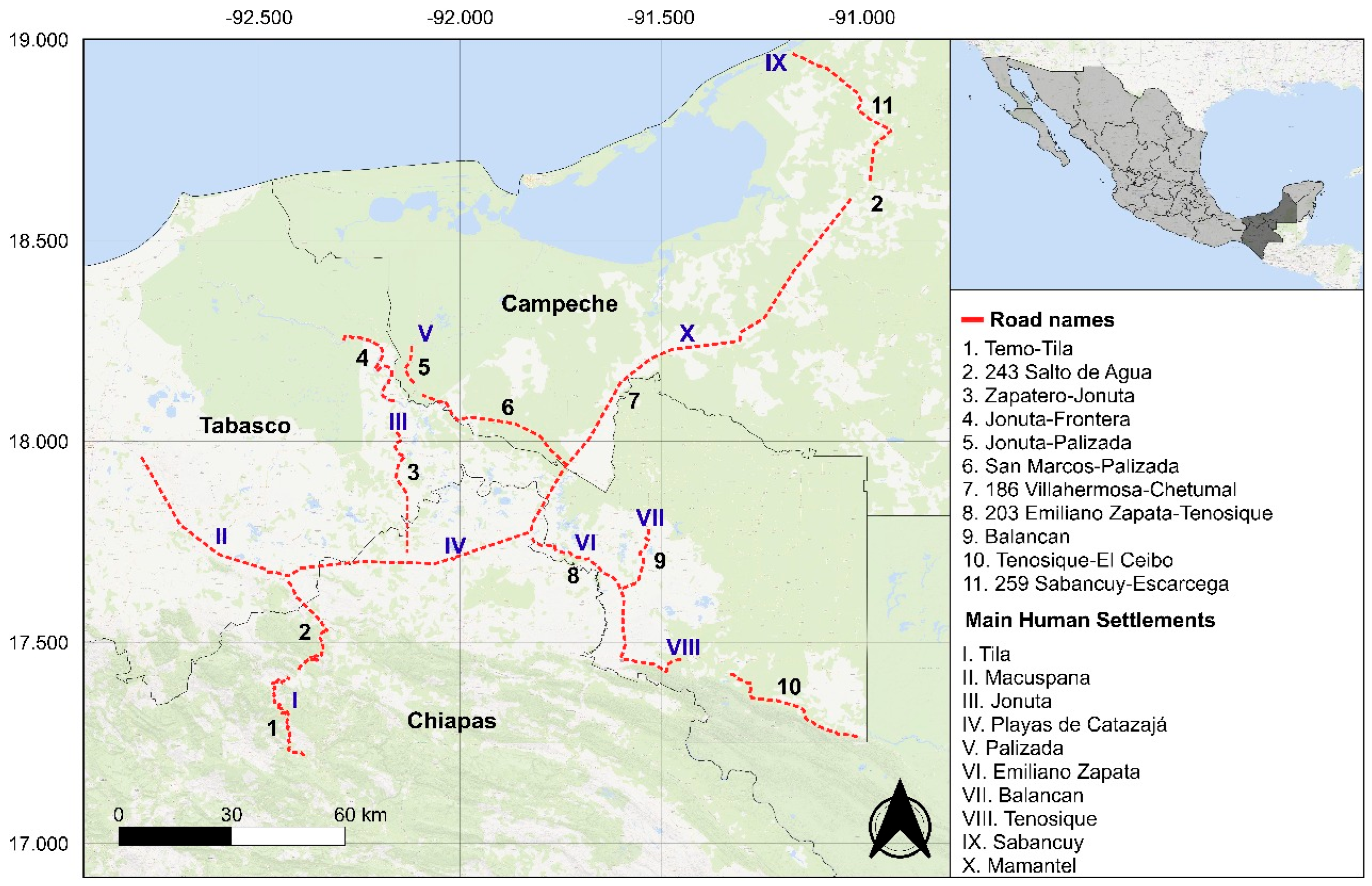
2.1. Study Area

The road network, consisting of federal roads (with greater length and reach, connecting different states and regions, and therefore subject to heavier traffic) and state highways (shorter, limited to a single state, and generally experiencing less traffic), is located between the states of Campeche, Chiapas, and Tabasco, with coordinates ranging from 17.21976816° N to 18.96406386° N and −92.79105556° W to −91.0146248° W (Figure 1). This network traverses a predominantly tropical humid forest ecosystem, which includes wetlands and alluvial plains. The Usumacinta and Grijalva rivers play a key ecological role, supporting an extraordinary level of biodiversity. The climate in this area is warm and humid (Af and Am according to Köppen [32]), with temperatures ranging from 24 °C to 28 °C and annual precipitation exceeding 2000 mm. The terrain is predominantly flat, with some hills and wetlands. Land use includes agriculture, livestock, urban development, and protected areas.

2.2. Data Collection

Roadkill data were recorded during the expansion/modernization works on a road network in the southeast of Mexico, from 11 August 2016, to 8 January 2017, and from 9 February 2023, to 18 October 2023. The temporal gap in data collection corresponds to a period during which no construction activities or related field trips were conducted along the monitored roads, and therefore no monitoring efforts took place. The monitoring consisted of a total of 40 trips and 10,865.2 km covered, during which the species, date, and geographic coordinates (latitude and longitude) of each incident were documented. The trips were conducted between 07:00 and 09:00 h, and between 16:00 and 18:00 h, as these were the regular times for departure to and return from the construction sites, departing from Villahermosa city towards the construction sites in Balancán, Carmen, Emiliano Zapata, Frontera, Jonuta, Libertad, Macuspana, Palenque, Palizada, Playas de Catazajá, Tenosique, and Tila. The surveys were carried out by vehicle, with travel speeds ranging between 60 and 100 km/h. Upon detection of a roadkill event, researchers halted the vehicle and approached the specimen to confirm the identification and collect detailed information. Specimens in advanced stages of decomposition that lacked clearly visible diagnostic features were not recorded. Data collection was primarily conducted by one or two researchers, with the involvement of two individuals being typical. The sampling design was mixed, consisting of systematic routes in terms of frequency and timing during the period in which construction works were carried out in the municipalities.
The records served as the foundation for further data extraction and analysis. The dataset included the following attributes: taxonomic classification (family, order, class, and common name), road characteristics (road name, type, and length), conservation status (IUCN Red List category, CITES appendix, and NOM-059-SEMARNAT-2010 classification), state and Land Cover. For comparisons, species were grouped into amphibians & reptiles, birds, small mammals (below 5 kg average for adults), and medium-large mammals (above 5 kg average for adults). This body mass criterion facilitates comparisons in line with thresholds commonly used in ecological and conservation studies [33,34,35]. The classification of carcasses by body mass in >5 kg or ≤5 kg was based on the average adult weight of the identified species rather than the specific specimen, due to the challenges in estimating the age or developmental stage of the individual—particularly in cases involving advanced decomposition or disfigurement Land cover information was obtained from the Uso del Suelo y Vegetación dataset (scale 1:250,000, Series VII) provided by the Comisión Nacional para el Conocimiento y Uso de la Biodiversidad (CONABIO) and produced by INEGI (19 November 2021).

2.3. Roadkill Rates and Kernel Density Estimations

To ensure standardized comparisons, only roads longer than 10 km and with more than five recorded roadkills were included in the analysis. Each road was measured by calculating the distance between the farthest recorded roadkill locations (the start and end points). Roadkill rates were calculated separately for amphibians & reptiles, birds, and mammals to enable comparisons among species groups. The roadkill rates were expressed using three different metrics. Roadkills per kilometer (RK/km) were calculated by dividing the total number of recorded roadkills for each group by the total length of the surveyed road. Roadkills per day (RK/day) were obtained by dividing the total number of recorded roadkills by the number of days sampled in that year. Similarly, Roadkills per month (RK/month) were determined by dividing the total number of recorded roadkills by the number of months sampled in that year. These calculations were performed separately for data collected in 2016 and 2023. Then, roadkill densities were estimated using the “Kernel Density Estimation” tool in QGIS v3, generating heatmaps to visualize areas with the highest concentration of events. KDE were calculated overall, by year, and by species group per year: birds, amphibians & reptiles, small mammals, and medium-large mammals.

2.4. Roadkill Rate Variations

To compare roadkill rates across Species Group, Road Type, and Land Cover, a vector map of the road network was generated in QGIS v3, and roads were segmented into 10 km sections with unique IDs. Roadkill records were then spatially associated with their respective segments, and the total number of events was calculated for each category within these attributes, enabling roadkill rate estimations. Data distribution was assessed using the Shapiro-Wilk test, which indicated non-normality across all categories (p < 0.05), justifying the use of non-parametric tests. The Kruskal-Wallis test was applied to evaluate differences in roadkill counts among road types, and Wilcoxon to evaluate differences in land covers, and species groups. When significant differences among land covers, and species groups were detected, Dunn’s test with Bonferroni correction identified specific category variations.

2.5. Computation of Continuous Variables

Data processing was conducted in Google Earth Engine (GEE). A 1000 m (or 1 km) buffer was applied around each roadkill point for four of the five variables: temperature, precipitation, human population density, and NDVI. This buffer was selected as effective for evaluating anthropogenic variables in landscape-sensitive species [36,37], so it is well suited for rural areas with highly variable settlement density. This scale captures local variations in landscape and climate [38], and topography [39] and has proven useful for assessing vegetation productivity via NDVI and its effects on habitat use [40]. The mean temperature in degrees Celsius was derived from the ERA5-Land dataset (ECMWF), averaging values over ±3 days from each event date and converting from Kelvin. Mean precipitation in millimeters per day was obtained from the CHIRPS dataset (UCSB-CHG) using the same temporal range and averaging values within the buffer. Human population density was extracted from the GHS-POP dataset (JRC), selecting the image corresponding to the closest year (2015 and 2020 data, respectively) and averaging values within the buffer. NDVI was calculated using Sentinel-2 imagery (ESA) acquired within ±15 days of each event. It was computed using the formula: NDVI = (B8B4)/(B8 + B4), where B8 corresponds to the near-infrared (NIR) band and B4 to the red band. The mean NDVI value within the buffer was extracted. Elevation (m.a.s.l) was obtained from the SRTM digital elevation model (USGS), extracting point-specific values at a 30 m resolution.

2.6. Principal Component Analysis (PCA)

To analyze the relationship between continuous variables and vertebrate roadkill records, a Principal Component Analysis (PCA), as implemented in recent ecological studies [41,42,43,44], was conducted. The variables (mean temperature, mean precipitation, elevation, human population density, and NDVI) were standardized using z-score normalization to ensure that all variables contributed equally to the analysis, preventing biases due to differences in measurement scales. Subsequently, they were discretized into 20 equidistant intervals. The optimal number of principal components was determined based on the proportion of explained variance, using statistical criteria such as the inspection of a scree plot and the eigenvalue-based retention rule. Finally, to facilitate the interpretation of the results, visual representations were generated to identify relationships among the variables and their contribution to the principal components.

2.7. Generalized Additive Models (GAM)

A generalized additive model (GAM) was employed to model the non-linear relationship between continuous variables and the frequency of roadkills. The model was fitted using a Poisson distribution with a logarithmic link function to appropriately capture the non-linear effects of predictors on roadkill counts. To prevent overfitting, the smoothing functions for each predictor variable were constrained to k = 4, a value determined through cross-validation. Model performance was assessed through the analysis of estimated coefficients, visualization of predictor effects, and specific diagnostic checks for GAMs. To evaluate model robustness, alternative link functions (log, identity, and square root) were explored, with model fit comparisons based on the Akaike Information Criterion (AIC). Furthermore, a 10-fold cross-validation was conducted to assess the predictive performance of the model, using the root mean squared error (RMSE) as a comparative metric across different link function configurations.

3. Results

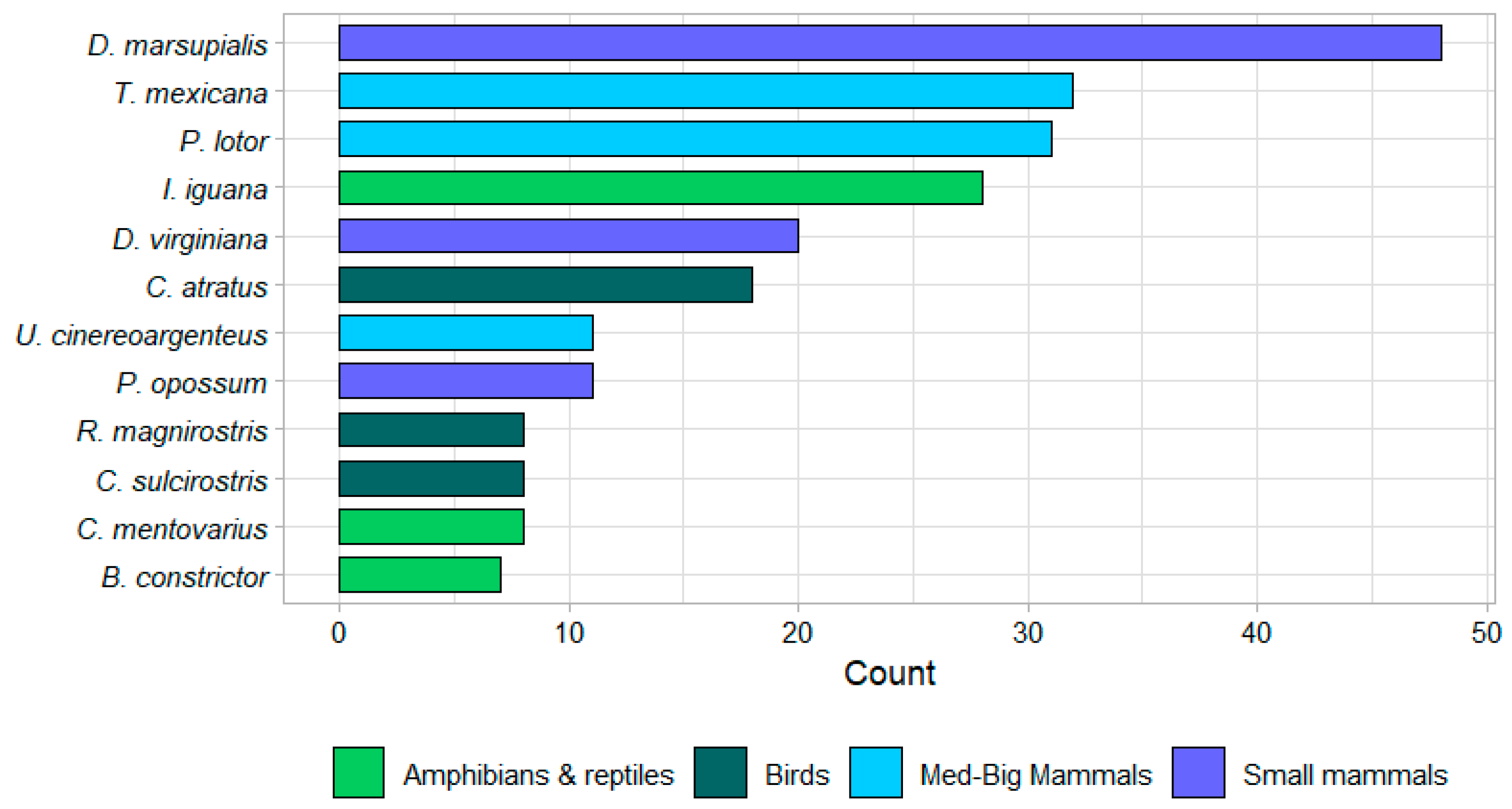
3.1. Roadkill Patterns

Monitoring was conducted over 150 days in 2016 and over 251 days in 2023 (35.8 weeks, 8.2 months). The study covered 11 roads, of which 7 (64%) were state roads and 4 (36%) were federal roads, spanning 647.3 km within the study area (Figure 1, Table S1).
A total of 354 roadkill events were recorded, including 272 in 2016 and 82 in 2023. These involved 198 mammals (94 small and 104 medium-large), 66 birds, and 90 amphibians and reptiles, which belong to 73 species from 43 families. Species richness was highest in birds (28 species) and amphibians & reptiles (26 species), followed by medium-large mammals (12 species) and small mammals (7 species). At the family level, birds had the highest diversity (18 families), followed by amphibians & reptiles (12 families), medium-large mammals (9 families), and small mammals (4 families). The three species most frequently recorded as roadkill were all mammals: Didelphis marsupialis (Linnaeus, 1758) (48, 13.56%), Tamandua mexicana (Saussure, 1860) (32, 9.04%), and Procyon lotor (Linnaeus, 1758) (31, 8.76%), totaling 111 events (31.36% of all records). The most frequently recorded bird was Coragyps atratus (Bechestein, 1793), with 18 (5.08%), while Iguana iguana (Linnaeus, 1758) was the most frequently recorded reptile, with 28 (7.91%) (Figure 2).

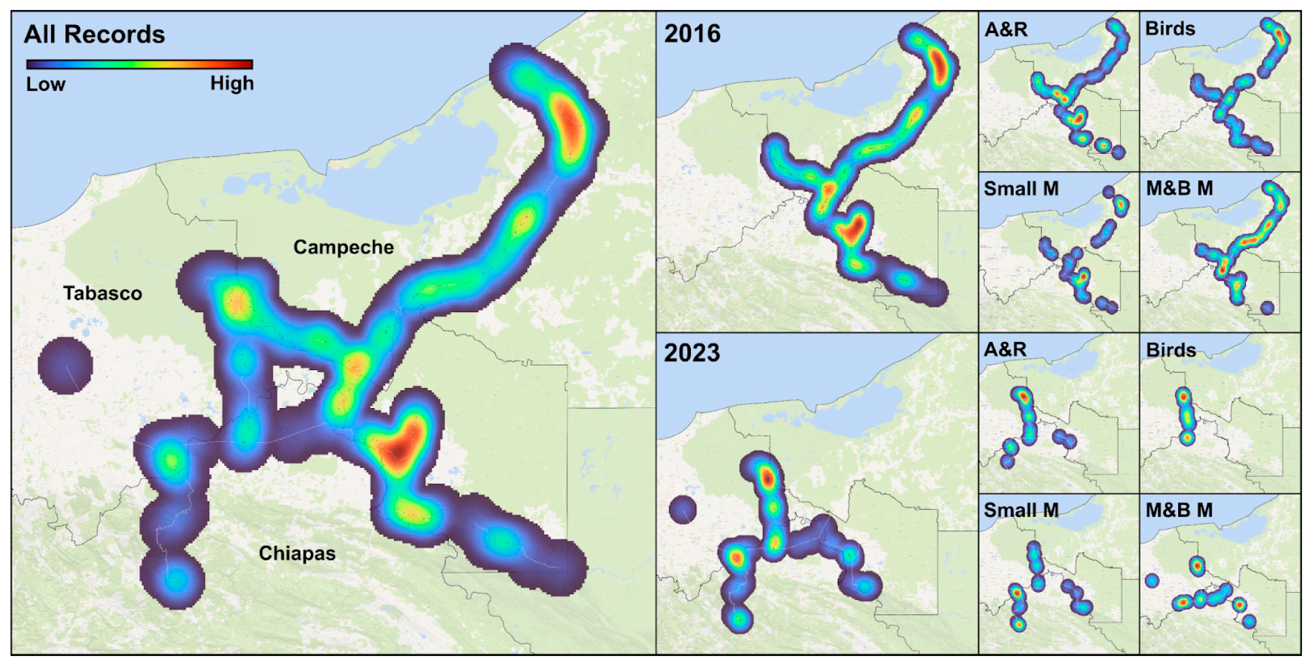
3.2. Wildlife Mortality Rates and Hotspot Identification via KDE

In 2016, within the area surveyed in that year, the roads with the highest roadkill incidence across multiple categories were Carretera Balancán and Carretera Federal 186 Villahermosa-Chetumal. Carretera Balancán had the highest roadkill rates per kilometer for amphibians & reptiles (0.422 RK/km) and mammals (0.797 RK/km). Meanwhile, Carretera Federal 186 Villahermosa-Chetumal recorded the highest daily (0.14 RK/day) and monthly (4.28 RK/month) bird roadkill, as well as the highest daily (0.373 RK/day) and monthly (11.42 RK/month) mammal roadkills. Meanwhile, in 2023, within the study area of that period, the most critical roads for roadkill were Carretera Estatal Jonuta-Frontera, Carretera Estatal Zapatero (Jalapa-Jonuta), and Carretera 243 Salto de Agua. Carretera Estatal Jonuta-Frontera recorded the highest roadkill rates for amphibians & reptiles (0.281 RK/km, 0.0398 RK/day, 1.219 RK/month) and also had the highest bird collision rate per kilometer (0.0845 RK/km). Carretera Estatal Zapatero (Jalapa-Jonuta) shares the highest daily (0.0119 RK/day) and monthly (0.337 RK/month) bird roadkill rates. As for mammals, Carretera 243 Salto de Agua registered the highest roadkill rate per kilometer (0.246 RK/km), making it the most affected road for this group (Table 1).
In the “All Records” map, which combines data from 2016 and 2023, the highest concentrations of roadkill hotspots were identified along Federal Highway 259 (Sabancuy–Escárcega) and at the intersection of State Highway Balancán with Federal Highway 203 (Emiliano Zapata–Tenosique). In 2016, roadkill events were primarily concentrated along Federal Highway 259 and State Highway Balancán, whereas in 2023, the most critical zones were located on State Highway Frontera–Jonuta and State Highway Salto de Agua. Regarding species groups, in 2016, hotspots of amphibian & reptile roadkills were primarily found along State Highway Balancán and at the intersection of State Highway Santo Domingo with Federal Highway 186. Bird roadkill hotspots were most prominent along Federal Highway 259, while small mammals had a more fragmented distribution, with a hotspot on State Highway Balancán. Medium-large mammals were more widely distributed along Federal Highway 186, with a notable hotspot at the intersection of Federal Highway 203 (Emiliano Zapata–Tenosique) and Federal Highway 186. By 2023, new hotspots of amphibian & reptile roadkill emerged on State Highway Frontera–Jonuta, while bird roadkill hotspots appeared on the same highway. Small mammals showed a new hotspot on State Highway Salto de Agua, whereas medium-large mammals registered additional hotspots on State Highway Balancán, State Highway Salto de Agua, and State Highway Frontera–Jonuta (Figure 3).

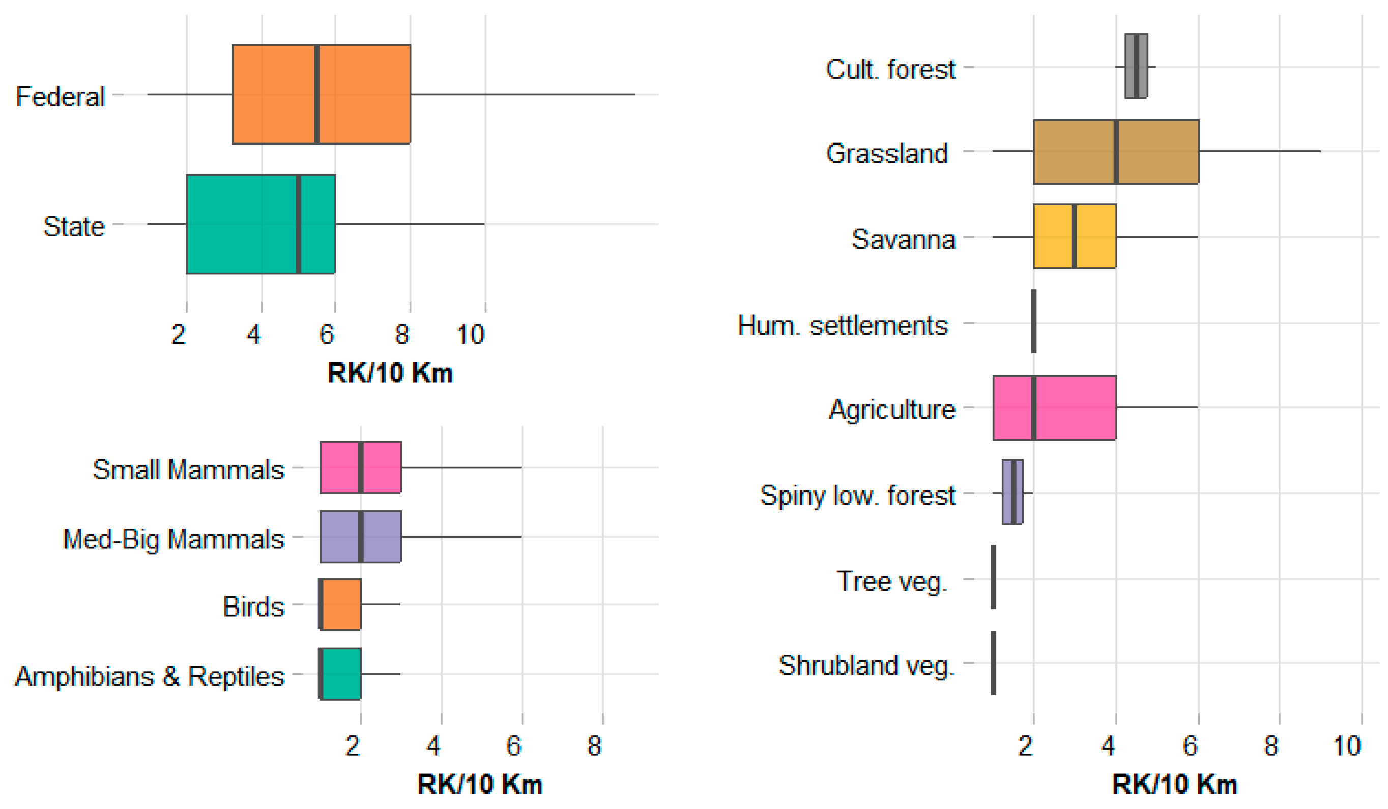
3.3. Variation in Roadkill Rates: Influence of Road Type, Faunal Group, and Land Cover

No significant differences were found in roadkill rates between federal and state (p > 0.05), indicating that road type does not strongly influence vertebrate mortality across the road network. When evaluating species groups, no statistical differences were detected between birds and amphibians & reptiles (p > 0.05) or between small and medium-large mammals (p > 0.05). However, a marginal trend toward significance was observed when comparing both mammal groups with birds and amphibians & reptiles (p-values close to 0.05), suggesting that mammals tend to exhibit higher roadkill rates than other taxa.
Although the Kruskal-Wallis test assessed global differences among categories of land cover, value dispersion suggested potential inference bias. To address this, a permutation test was performed, generating a null distribution through random data rearrangements to evaluate effect significance without relying on theoretical distributions. Thus, the highest median number of roadkill incidents was observed in Cultivated forest (4.5), followed by Grassland (4) and Savanna (3). Agriculture and Human settlements had a median of 2, while Spiny low. forest had a slightly lower value (1.5). The lowest median values were recorded in Shrubland vegetation and Tree vegetation, both at 1. Regarding data variability, Grassland exhibited the highest interquartile range (IQR = 4), while Savanna and Agriculture showed intermediate dispersion levels (IQR = 2 and 3, respectively). Cultivate forest and Spiny low forest had lower variability (IQR = 0.5), whereas human settlements, Shrubland vegetation, and Tree vegetation. displayed a homogeneous distribution of roadkill incidents (IQR = 0) (Figure 4).

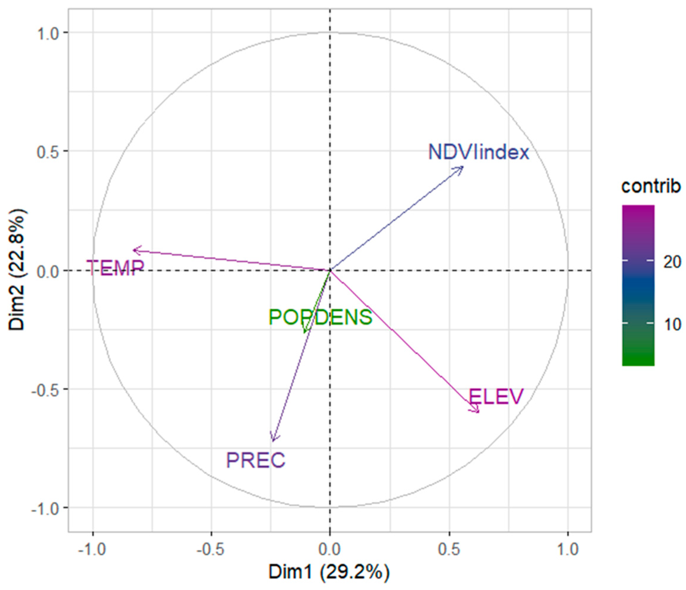
3.4. Dimensionality Reduction via PCA

The first four components together account for 88.8% of the total variance, capturing most of the dataset’s structure while minimizing dimensionality loss. The results indicated that the first principal component (PC1) accounts for 29.2% of the variance, the second principal component (PC2) explains 22.8%, and the third principal component (PC3) contributes 20.1%. Together, PC1 and PC2 capture 52.0% of the total variability in the dataset, while the combined contribution of the first three principal components reaches 72.1% of the total variance. Regarding the contribution of variables to the principal components, elevation and temperature exhibit the highest contributions to overall data variability. The normalized difference vegetation index (NDVI) and precipitation show moderate contributions, whereas human population density has the lowest contribution, indicating that its impact on dataset variability is limited compared to environmental variables. PC1 is primarily influenced by temperature (47.20%), whereas PC2 is predominantly associated with precipitation (45.59%). These findings suggest an underlying structure in the data that differentiates collision sites according to specific environmental gradients. (Figure 5).
The generalized additive model (GAM) explained 17.4% of the deviance (adjusted R2 = 0.118). Among the smooth terms, elevation (ELEV) exhibited a marginal effect (p = 0.0951), whereas temperature (TEMP), precipitation (PREC), human population density (POPDENS), and NDVI were not statistically significant (p > 0.1). A comparison of alternative link functions using the Akaike Information Criterion (AIC) showed that the log link model (AIC = 668.18) outperformed the identity (AIC = 669.05) and square root (AIC = 668.63) alternatives. Cross-validation yielded an RMSE of 0.688, indicating moderate predictive accuracy. Model diagnostics, including the UBRE criterion and basis dimension tests, confirmed an adequate fit. However, low p-values in the k-index tests suggest that further refinement of the basis dimension may be necessary.

4. Discussion

This study provides the first multi-group and multi-year analysis of wildlife-vehicle collisions (WVCs) in the Gulf of Mexico, revealing significant roadkill hotspots along key road networks and identifying mammals as the most affected group. While environmental variables showed limited predictive power, land cover patterns and elevation exhibited marginal influences, highlighting the complexity of roadkill dynamics in tropical ecosystems.
Across a road network in southeastern Mexico, integrating data from two monitoring periods (2016 and 2023). Over a total of 401 monitoring days, we recorded 354 roadkill events, with mammals exhibiting the highest roadkill rates, particularly Didelphis marsupialis, Tamandua mexicana, and Procyon lotor. Birds and amphibians & reptiles showed lower overall mortality, although Coragyps atratus and Iguana iguana stood out as the most frequently affected species in their respective groups. Spatial analyses identified key roadkill hotspots along Federal Highway 259, State Highway Balancán, and State Highways Frontera–Jonuta and Salto de Agua, where roadkill incidence was consistently high. Although no significant differences were detected between federal and state roads, mammals exhibited a marginal trend toward higher mortality rates. Land cover also influenced roadkill patterns, with the highest incidence observed in cultivated forests, grasslands, and savannas. Principal Component Analysis (PCA) revealed that temperature and precipitation were the primary environmental variables driving variation in roadkill patterns, while the Generalized Additive Model (GAM) suggested that elevation exerted a weak but notable effect. These findings highlight the spatial and species group variability of roadkill events, emphasizing the need for targeted mitigation strategies in high-risk areas.
A broader review of wildlife roadkills in tropical ecosystems by Monge-Nájera (2018) [8] highlights the predominance of mammals, regardless of body size, as the vertebrate group with the highest roadkill rates. Likewise, Medrano-Vizcaíno et al. (2023) [10] recently reviewed vertebrate roadkill in Latin America, reporting a higher prevalence of medium-sized mammals and large-bodied birds. Kolb et al. (2025) [45] conducted a systematic review and meta-analysis in the Neotropics, which aligns with these findings, with mammals exhibiting the largest effect size, followed by amphibians and reptiles. Their findings closely align with ours, where mammals exhibited the highest roadkill rates, and the bird species with the highest incidence was Coragyps atratus, a large-bodied scavenger. The prevalence of mammals in roadkill records is not only a documented pattern in reviews but also reflects the research effort in Mexico, where most vertebrate roadkill studies have focused on this group [46,47,48,49]. Among the studied species, large mammals such as Panthera onca (Linnaeus, 1758) [50] and the black bear Ursus americanus (Pallas, 1780) [51,52] have been the focus of specific research.
Geographically, the most studied region has been the south-southeast of the country, particularly in the states of Chiapas, Guerrero, Tabasco, and Veracruz [20,31,47,53,54]. Additionally, Sinaloa and Michoacán have also been key regions for roadkill research [31,49]. In this regional context, our results align with previous studies indicating that mammals are the most affected group by roadkill [20,54] highlighting their vulnerability to traffic exposure and landscape fragmentation caused by roads. This study presents the first analysis of wildlife-vehicle collisions in the Gulf of Mexico using multi-group and multi-year data, making a key contribution to the growing body of knowledge on this critical issue. Its significance is particularly relevant in the context of rapid urban expansion and the development of associated infrastructure within biodiversity hotspots, where mitigating these impacts is increasingly urgent.
The relationship between road type and wildlife mortality was not consistent across studies. While we found no significant differences between state and federal roads Cervantes-Huerta et al. (2017) [31] documented higher mortality on highways compared to freeways with different types of central barriers. This implies that beyond road type, other infrastructure may influence the incidence of roadkill events. Concerning land cover, it is widely recognized that land use adjacent to roads influences wildlife road mortality [54,55]. However, neither the results of this study nor the existing literature reveal consistent patterns, and there is still no consensus on the influence of vegetation structure and type on roadkill rates. In this road network in the Gulf of Mexico, roadkill incidents were most frequent in cultivated forests, followed by grasslands and savannas. This finding is consistent with García-Sánchez et al. (2023) [20], who reported higher roadkill rates in low-urbanization areas, but contrasts with Cervantes-Huerta et al. (2017) [31], who found greater mortality in stretches with low sinuosity and high forest cover. Other studies suggest that forest-dependent species tend to avoid crossing roads [9], which could explain the low mortality observed in natural forests but not the high incidence in cultivated forests. Additionally, the higher frequency of roadkill in grasslands aligns with the idea that early-successional vegetation is associated with increased mortality rates, as is the presence of roadside grass [56,57]. However, the variability observed in these environments indicates that other landscape features may be influencing this effect.
Agricultural areas and human settlements exhibited intermediate roadkill values. While some studies have reported that agricultural landscapes increase roadkill rates for birds and mammals [58], the values in this study were not particularly high. This may be due to differences in species composition or local agricultural practices. Among the most recorded species in this land cover were Didelphis marsupialis, D. virginiana (opossums) and Procyon lotor (raccoon). These species are known to exploit anthropogenic resources, such as crops and food waste, which increase their presence in these modified habitats. Studies have shown that opossums, such as Didelphis virginiana, often increase in density in agricultural ecosystems [59] and benefit from the availability of food sources like carrion linked to human land use [60]. Similarly, raccoons (Procyon lotor) are known to take advantage of food subsidies in human-altered environments, particularly in agricultural areas where they feed on C4 plants such as corn [61]. These behaviors may increase their exposure to roads, making them more vulnerable to collisions. In the case of human settlements, lower mortality rates align with studies indicating that anthropogenic activity reduces wildlife presence and, consequently, the risk of collisions [62]. Finally, the lowest values were recorded in shrublands and tree vegetation, with this being the land cover where some studies have documented a higher species richness in roadkill incidents [63]. These discrepancies suggest that additional ecological factors—such as habitat availability, prey presence, shelter, and species movement—may modulate the relationship between landscape cover and wildlife mortality [64], varying across regions and ecological contexts.
The impact of environmental variables on wildlife collisions has been extensively studied and debated. Contrary to previous studies that identified a significant influence of temperature and precipitation on wildlife collision patterns [1,65], our results did not show a statistically significant relationship between these variables and collision distribution. These patterns may be more clearly understood in areas with distinct climatic seasons, such as subtropical and temperate zones, or in studies conducted over longer periods, which would allow for a more detailed capture of the microclimatic variability typical of tropical ecosystems. Similarly, we found no clear relationship with population density. In this regard, previous research has indicated that the boundaries between urban and natural areas may be critical risk points for dispersing wildlife [66], and that the risk of collisions tends to increase with road density up to a certain threshold [42], suggesting that, rather than human population density itself, other factors associated with human settlements might be influencing collision occurrence.
Regarding vegetation cover, although the NDVI did not show a significant effect in our model, this and other spectral indices are increasingly being used to describe habitat complexity and analyze spatial and temporal patterns of wildlife co6llisions [67]. Finally, the only variable with a marginal effect in our model was elevation. However, the relationship between these variable and collision rates or events is unclear. In this regard, other factors related to topography or road characteristics, which require more intensive sampling to be incorporated into the analysis, may be influencing the distribution of collisions in our study area.
Given the considerations outlined above, the Gulf of Mexico is a priority area for research, especially in light of the increasing expansion of road infrastructure and its potential effects on biodiversity. The southeastern region of Mexico, which includes the states of Campeche, Chiapas and Tabasco, houses one of the largest and best-preserved tropical forests on the continent, surpassed only by the Amazon [68]. Consequently, the construction of the Mayan Train, by traversing these sensitive ecosystems, poses a significant threat, potentially fragmenting vital habitats, disrupting the migration patterns of various species, and impacting ecological connectivity, thereby increasing the risk of wildlife-vehicle collisions. Such disturbances can lead to high mortality rates among mammals, reptiles, and birds, which would negatively affect local population dynamics and alter the ecological interactions essential for maintaining ecosystem balance [69].
To better understand these impacts, it is necessary to standardize sampling methods and ensure their systematic and homogeneous application across time and space. Additionally, implementing a sampling design along an altitudinal gradient would allow for a detailed evaluation of the effect of elevation or other topographical and road characteristics on wildlife collisions. Furthermore, increased sampling efforts would facilitate the collection of sufficient records to make more detailed comparisons within vertebrate groups. In this context, several studies have highlighted the need for specific mitigation measures for each species group, as collision hotspots and high-risk areas vary depending on the group analyzed, suggesting differences in species’ vulnerability to their environment [10,41,70]. To reduce mortality in biodiverse regions, it is recommended to avoid development in rural areas with high biodiversity, valuable water bodies, migratory corridors, and areas inhabited by vulnerable species [71]. Additionally, strategies to improve data collection have been proposed, such as road management, the implementation of wildlife crossing structures, and the use of participatory methodologies like citizen science [51]. Finally, in line with what other researchers in the field have indicated [72], this study emphasizes the importance of understanding patterns of roadkill in tropical ecosystems.

5. Conclusions

Our findings, partially consistent with those reported by other authors, highlight the urgency of expanding research efforts in the region, underscoring the critical importance of generating localized, high-resolution data to inform evidence-based conservation actions. Building upon previous studies, our research contributes valuable new evidence to inform the design of effective mitigation strategies that safeguard biodiversity and ecological connectivity in the Neotropical region, where rapid infrastructure expansion threatens critical ecosystems.
Our results weakly support the initial hypothesis. While vertebrate roadkill rates did not significantly differ between federal and state roads or among major faunal groups, mammals exhibited a tendency toward higher roadkill rates. Furthermore, although environmental gradients such as elevation and temperature appeared to influence the spatial distribution of collision sites, their effects were not statistically robust in the generalized additive model. These findings highlight the complexity of roadkill dynamics and the need for further hypothesis-driven research to disentangle the roles of ecological and infrastructural factors in shaping collision patterns.
Understanding the spatial and species group variability of wildlife-vehicle collisions (WVCs) is fundamental for developing context-specific conservation strategies. Our results reveal significant differences in roadkill patterns across habitats and species groups, emphasizing the need to refine predictive models by integrating ecological factors (species behavior, movement patterns) and infrastructural variables (road design, traffic volume). Such integration will improve the precision of future roadkill risk assessments and mitigation planning.
Given the ecological sensitivity of the Gulf of Mexico and other biodiversity hotspots in southeastern Mexico, future efforts should prioritize targeted research and long-term monitoring in regions where road networks intersect critical habitats. Identifying high-risk areas and vulnerable species will enable the development of adaptive mitigation strategies that minimize the impact of road infrastructure on wildlife.
Achieving meaningful conservation outcomes requires strengthening collaboration among researchers, policymakers, infrastructure developers, and local communities. This interdisciplinary approach will be crucial for implementing evidence-based solutions that balance infrastructure development with biodiversity conservation. Promoting participatory methodologies, such as citizen science and community-based monitoring, can further enhance data collection and ensure the long-term success of mitigation initiatives.

Supplementary Materials

The following supporting information can be downloaded at: https://www.mdpi.com/article/10.3390/wild2030024/s1, Table S1: Wildlife-Vehicle Collisions Database.

Author Contributions

Conceptualization, G.P.-M. and D.L.B.-T.; methodology, D.L.B.-T.; software, B.B.B.-M.; validation, G.P.-M., D.L.B.-T. and J.R.F.-A.; formal analysis, D.L.B.-T.; investigation, J.R.F.-A., G.P.-M. and M.A.M.M.; resources, J.R.F.-A., G.P.-M. and M.A.M.M.; data curation, B.B.B.-M.; writing—original draft preparation, D.L.B.-T.; writing—review and editing, G.P.-M.; visualization, G.P.-M. and D.L.B.-T.; supervision, G.P.-M.; project administration, M.A.M.M.; funding acquisition, J.R.F.-A., G.P.-M. and M.A.M.M. All authors have read and agreed to the published version of the manuscript.

Funding

This research was partially funded by the Comisión Nacional de Áreas Naturales Protegidas (CONANP) through the Programa de Conservación de Especies en Riesgo (PROCER) in 2016, under the supervision of the Dirección Regional Planicie Costera y Golfo de México Agreement Number PROCER/DRPCGM/01/2016. Data collection conducted during the 2016 monitoring period was supported by this funding. The 2023 monitoring period was carried out with self-funded resources provided by Ecología y Manejo Ambiental en Obras S.A. de C.V. No additional external funding was received for this research.

Institutional Review Board Statement

Not applicable.

Informed Consent Statement

Not applicable.

Data Availability Statement

The original contributions presented in this study are included in the article. Further inquiries can be directed to the corresponding author(s).

Acknowledgments

We would like to express our sincere gratitude to Santiago Diwisch Narváez and Valentina López Velasco for reviewing the final document and contributing valuable improvements, as well as for their assistance with formatting and text standardization. We are also deeply thankful to the technical field staff of COBIUS who participated in the roadkill monitoring surveys: Saúl de la Cruz Córdova, Guillermo Sánchez, and Marco Antonio Torres Pérez. Their dedication and commitment were essential to the success of this project. Special thanks go to Gabriela López Ramírez for her continued support and close follow-up during the implementation of the PROCER project in 2016. Finally, we wish to honor the memory of José Luis Álvarez Flores, a devoted environmentalist who lost his life in the line of duty and played a key role in advancing roadkill monitoring initiatives in the region. His passion and legacy continue to inspire conservation efforts in southeastern Mexico.

Conflicts of Interest

Author José Roberto Frías-Aguilar was employed by the company Ecología y Manejo Ambiental en Obras S.A. de C.V. The remaining authors declare that the research was conducted in the absence of any commercial or financial relationships that could be construed as a potential conflict of interest.

Abbreviations

The following abbreviations are used in this manuscript:
CITESConvention on International Trade in Endangered Species of Wild Fauna and Flora
CONABIOComisión Nacional para el Conocimiento y Uso de la Biodiversidad
GAMGeneralized Additive Models
GEEGoogle Earth Engine
IUCNInternational Union for Conservation of Nature
KDEKernel Density Estimation
NDVINormalized Difference Vegetation Index
PCAPrincipal Component Analysis
RK/dayRoadkills per day
RK/monthRoadkills per month
RK/kmRoadkills per kilometer
RMSERoot Mean Squared Error
SRTMShuttle Radar Topography Mission
UBREUn-Biased Risk Estimator
WVCsWildlife-vehicle collisions

References

  1. Schwartz, A.; Shilling, F.; Perkins, S. The value of monitoring wildlife roadkill. Eur. J. Wildl. Res. 2020, 66, 18. [Google Scholar] [CrossRef]
  2. Silva, I.; Crane, M.; Savini, T. The road less traveled: Addressing reproducibility and conservation priorities of wildlife-vehicle collision studies in tropical and subtropical regions. Glob. Ecol. Conserv. 2021, 27, e01584. [Google Scholar] [CrossRef]
  3. Bíl, M.; Andrášik, R.; Cícha, V.; Arnon, A.; Kruuse, M.; Langbein, J.; Seiler, A. COVID-19 related travel restrictions prevented numerous wildlife deaths on roads: A comparative analysis of results from 11 countries. Biol. Conserv. 2021, 256, 109076. [Google Scholar] [CrossRef] [PubMed]
  4. Litvaitis, J.A.; Tash, J.P. An approach toward understanding wildlife-vehicle collisions. Environ. Manag. 2008, 42, 688–697. [Google Scholar] [CrossRef] [PubMed]
  5. Bennett, V.J. Effects of Road Density and Pattern on the Conservation of Species and Biodiversity. Curr. Landsc. Ecol. Rep. 2017, 2, 1–11. [Google Scholar] [CrossRef]
  6. Balčiauskas, L.; Kučas, A.; Balčiauskienė, L. The impact of roadkill on cervid populations in Lithuania. Forests 2023, 14, 1224. [Google Scholar] [CrossRef]
  7. Arroyave, M.D.P.; Gómez, C.; Gutiérrez, M.E.; Múnera, D.P.; Zapata, P.A.; Vergara, I.C.; Ramos, K.C. Impactos de las carreteras sobre la fauna silvestre y sus principales medidas de manejo. Rev. EIA 2006, 5, 45–57. [Google Scholar]
  8. Monge-Nájera, J. Road kills in tropical ecosystems: A review with recommendations for mitigation and for new research. Rev. Biol. Trop. 2018, 66, 722–738. [Google Scholar] [CrossRef]
  9. Pinto, F.A.; Clevenger, A.P.; Grilo, C. Effects of roads on terrestrial vertebrate species in Latin America. Environ. Impact Assess. Rev. 2020, 81, 106337. [Google Scholar] [CrossRef]
  10. Medrano-Vizcaíno, P.; Grilo, C.; Brito-Zapata, D.; González-Suárez, M. Landscape and road features linked to wildlife mortality in the Amazon. Biodivers. Conserv. 2023, 32, 4337–4352. [Google Scholar] [CrossRef]
  11. Cullen, L.; Stanton, J.; Lima, F.; Uezu, A.; Perilli, M.; Akçakaya, H. Implications of fine-grained habitat fragmentation and road mortality for jaguar conservation in the Atlantic Forest, Brazil. PLoS ONE 2016, 11, e0167372. [Google Scholar] [CrossRef] [PubMed]
  12. González-Gallina, A.; Hidalgo-Mihart, M.G. A review of road-killed felids in Mexico. Therya 2018, 9, 147–159. [Google Scholar] [CrossRef]
  13. Canales-Delgadillo, J.; Pérez-Ceballos, R.; Zaldívar-Jiménez, A.; Gómez-Ponce, M.; Vázquez-Pérez, N.; Rosa, M.D.L.; Potenciano-Morales, L. Muertes por tráfico sobre la carretera costera del golfo de México: ¿cuántas y cuáles especies de fauna silvestre se están perdiendo? Rev. Mex. Biodivers. 2020, 91, 913189. [Google Scholar] [CrossRef]
  14. Felder, D.L.; Camp, D.K. (Eds.) Gulf of Mexico Origin, Waters, and Biota: Biodiversity; Texas A&M University Press: College Station, TX, USA, 2009. [Google Scholar]
  15. Engle, V.D. Estimating the provision of ecosystem services by Gulf of Mexico coastal wetlands. Wetlands 2011, 31, 179–193. [Google Scholar] [CrossRef]
  16. Navarro-Sigüenza, A.G.; Rebón-Gallardo, M.F.; Gordillo-Martínez, A.; Townsend Peterson, A.; Berlanga-García, H.; Sánchez-González, L.A. Biodiversidad de aves en México. Rev. Mex. Biodivers. 2014, 85, S476–S495. [Google Scholar] [CrossRef]
  17. Cohen, E.B.; Barrow, W.C., Jr.; Buler, J.J.; Deppe, J.L.; Farnsworth, A.; Marra, P.P.; Moore, F.R. How do en route events around the Gulf of Mexico influence migratory landbird populations? Condor Ornithol. Appl. 2017, 119, 327–343. [Google Scholar] [CrossRef]
  18. Liceaga-Correa, M.; Uribe-Martínez, A.; Cuevas, E. Ecological vulnerability of adult female marine turtles as indicators of opportunities for regional socioecosystem management in the southern gulf of mexico. Sustainability 2021, 14, 184. [Google Scholar] [CrossRef]
  19. Pozo-Montuy, G.; Bonilla-Sánchez, Y.M. Population decline of an endangered primate resulting from the impact of a road in the Catazajá wetlands, Chiapas, México. Therya Notes 2022, 3, 75–81. [Google Scholar] [CrossRef]
  20. García-Sánchez, S.; Juárez-Agis, A.; Alvarez-Alvarez, E.A.; Salome, B.O.; Zeferino-Torres, J.; Rivas-González, M.; Osorio-Rodriguez, A.N. Wild vertebrates’ roadkill across human settlements of the Mexican Southern Pacific. Rev. Biol. Trop. 2023, 71, e53600. [Google Scholar]
  21. Pinto, C.M.; Soto, J.S.V.; Flatt, E.; Barboza, K.; Whitworth, A. Identifying wildlife road crossing mitigation sites using a multi-data approach—A case study from southwestern Costa Rica. J. Environ. Manag. 2024, 361, 121263. [Google Scholar] [CrossRef]
  22. Neumann, W.; Ericsson, G.; Dettki, H.; Bunnefeld, N.; Keuler, N.S.; Helmers, D.P.; Radeloff, V.C. Difference in spatiotemporal patterns of wildlife road-crossings and wildlife-vehicle collisions. Biol. Conserv. 2012, 145, 70–78. [Google Scholar] [CrossRef]
  23. Abraham, J.O.; Mumma, M.A. Elevated wildlife-vehicle collision rates during the COVID-19 pandemic. Sci. Rep. 2021, 11, 20391. [Google Scholar] [CrossRef] [PubMed]
  24. Coffin, A.W. From roadkill to road ecology: A review of the ecological effects of roads. J. Transp. Geogr. 2007, 15, 396–406. [Google Scholar] [CrossRef]
  25. Gunson, K.E.; Mountrakis, G.; Quackenbush, L.J. Spatial wildlife-vehicle collision models: A review of current work and its application to transportation mitigation projects. J. Environ. Manag. 2011, 92, 1074–1082. [Google Scholar] [CrossRef] [PubMed]
  26. D’Amico, M.; Périquet, S.; Román, J.; Revilla, E. Road avoidance responses determine the impact of heterogeneous road networks at a regional scale. J. Appl. Ecol. 2016, 53, 181–190. [Google Scholar] [CrossRef]
  27. Colino-Rabanal, V.J.; Lizana, M. Herpetofauna and roads: A review. Basic Appl. Herpetol. 2012, 26, 5–31. [Google Scholar] [CrossRef]
  28. Torres, A.; Palacín, C.; Seoane, J.; Alonso, J.C. Assessing the effects of a highway on a threatened species using Before-During-After and Before-During-After-Control-Impact designs. Biol. Conserv. 2011, 144, 2223–2232. [Google Scholar] [CrossRef]
  29. Ramírez, M.I.; Miranda, R.; Zubieta, R.; Jiménez, M. Land cover and road network map for the Monarch Butterfly Biosphere Reserve in Mexico, 2003. J. Maps 2007, 3, 181–190. [Google Scholar] [CrossRef]
  30. Fahrig, L.; Rytwinski, T. Effects of roads on animal abundance: An empirical review and synthesis. Ecol. Soc. 2009, 14, 21. Available online: https://www.jstor.org/stable/26268057 (accessed on 15 February 2020). [CrossRef]
  31. Cervantes-Huerta, R.; Escobar, F.; García-Chávez, J.H.; González-Romero, A. Atropellamiento de vertebrados en tres tipos de carretera de la región montañosa central de Veracruz, México. Acta Zool. Mex. 2017, 33, 472–481. [Google Scholar] [CrossRef]
  32. Köppen, W. Klassifikation der Klimate nach Temperatur, Niederschlag und Jahresablauf. Petermanns Geogr. Mitt. 1918, 64, 193–203, 243–248. Available online: https://commons.wikimedia.org/wiki/File:Klassifikation_der_Klimate_nach_Temperatur,_Niederschlag_und_Jahreslauf_(1918).pdf (accessed on 15 February 2020).
  33. Stoddart, D.M. (Ed.) Ecology of Small Mammals; Springer Science & Business Media: Berlin/Heidelberg, Germany, 2012. [Google Scholar]
  34. Ascensão, F.; LaPoint, S.; van der Ree, R. Roads, traffic and verges: Big problems and big opportunities for small mammals. In Handbook of Road Ecology; Wiley Online Library: Hoboken, NJ, USA, 2015; pp. 325–333. [Google Scholar]
  35. Boonstra, R.; Krebs, C.J.; Reid, D.G. Studying small mammal population dynamics: Advice to consider and pitfalls to avoid-a 60-year overview. Can. J. Zool. 2025, 103, 1–12. [Google Scholar] [CrossRef]
  36. Nagy-Reis, M.B.; Estevo, C.A.; Setz, E.Z.F.; Ribeiro, M.C.; Chiarello, A.G.; Nichols, J.D. Relative importance of anthropogenic landscape characteristics for Neotropical frugivores at multiple scales. Anim. Conserv. 2017, 20, 520–531. [Google Scholar] [CrossRef]
  37. Boggie, M.A.; Collins, D.P.; Donnelly, J.P.; Carleton, S.A. Land use, anthropogenic disturbance, and riverine features drive patterns of habitat selection by a wintering waterbird in a semi-arid environment. PLoS ONE 2018, 13, e0206222. [Google Scholar] [CrossRef] [PubMed]
  38. Williams, J.J.; Freeman, R.; Spooner, F.; Newbold, T. Vertebrate population trends are influenced by interactions between land use, climatic position, habitat loss and climate change. Glob. Change Biol. 2022, 28, 797–815. [Google Scholar] [CrossRef]
  39. Steyaert, S.M.; Zedrosser, A.; Elfström, M.; Ordiz, A.; Leclerc, M.; Frank, S.C.; Swenson, J.E. Ecological implications from spatial patterns in human-caused brown bear mortality. Wildl. Biol. 2016, 22, 144–152. [Google Scholar] [CrossRef]
  40. Lewis, J.S.; Spaulding, S.; Swanson, H.; Keeley, W.; Gramza, A.R.; VandeWoude, S.; Crooks, K.R. Human activity influences wildlife populations and activity patterns: Implications for spatial and temporal refuges. Ecosphere 2021, 12, e03487. [Google Scholar] [CrossRef]
  41. Chyn, K.; Lin, T.E.; Wilkinson, D.P.; Tracy, J.L.; Lawing, A.M.; Fitzgerald, L.A. Fine-scale roadkill risk models: Understanding the intersection of wildlife and roads. Biodivers. Conserv. 2021, 30, 139–164. [Google Scholar] [CrossRef]
  42. Kent, E.; Schwartz, A.L.; Perkins, S.E. Life in the fast lane: Roadkill risk along an urban–rural gradient. J. Urban Ecol. 2021, 7, juaa039. [Google Scholar] [CrossRef]
  43. Lombardi, J.V.; Yamashita, T.J.; Blackburn, A.; Young Jr, J.H.; Tewes, M.E.; Anderson, C.J. Examining the spatial structure of woody cover within a highway road effect zone for ocelots in Texas. Urban Ecosyst. 2023, 26, 1057–1069. [Google Scholar] [CrossRef]
  44. Yamashita, T.J.; Perotto-Baldivieso, H.L.; Wester, D.B.; Ryer, K.W.; Kline, R.J.; Tewes, M.E.; Lombardi, J.V. A multivariate approach to assessing landscape structure effects on wildlife crossing structure use. Ecol. Process. 2024, 13, 76. [Google Scholar] [CrossRef]
  45. Kolb, M.; Cruz-Cano, R.; Saldaña-Vázquez, R.A. Atropellamientos de vertebrados terrestres en carreteras: Los vacíos cuantitativos para el neotrópico. Acta Zoológica Mex. (NS) 2025, 41, 1–35. [Google Scholar] [CrossRef]
  46. Ríos-Solís, J.A.; Lavariega, M.C.; Flores-Martínez, J.J.; Sanchez, V.; Pech-Canché, J.M. Roadkills on medium-sized mammals in a tropical region in southern Mexico. SSRN 2024. [Google Scholar] [CrossRef]
  47. Ruíz-Ramírez, L.; González-Gallina, A.; Soto, V.; Pacheco-Figueroa, C.J.; Pech-Canché, J.M. Comparison of road-killed mammals on roads of different types of jurisdictions and traffic volume in Veracruz, México. Therya Notes 2022, 3, 82–86. [Google Scholar] [CrossRef]
  48. Cervantes-Huerta, R.; Durán-Antonio, J. Seasonal variation of mammal roadkill hotspots in the Sierra Madre Occidental, México. Therya Notes 2022, 3, 70–74. [Google Scholar] [CrossRef]
  49. Rubio-Rocha, Y.; Gaxiola-Camacho, S.; Morales-García, M.; Artigas-Gutiérrez, B.; Sánchez-Ríos, A.; Carvajal-Sauceda, F.; Espinoza-Evans, G. First records of road-killed mammals in the state of Sinaloa, México. Therya Notes 2022, 3, 53–58. [Google Scholar] [CrossRef]
  50. Rubio-Rocha, Y.; Chávez-Tovar, C.; Gaxiola-Camacho, S.; Ayala-Rubio, M.; Alvarado-Hidalgo, D.; Pérez-Camacho, A.; Sicairos-López, J. Impact of the roadkill of a jaguar cub (Panthera onca) on social networks and the inhabitants of Sinaloa, México. Therya Notes 2022, 3, 92–97. [Google Scholar] [CrossRef]
  51. Zarco-González, Z.; Carrera-Treviño, R.; Monroy-Vilchis, O. Conservation of black bear (Ursus americanus) in Mexico through GPS tracking: Crossing and roadkill sites. Wildl. Res. 2023, 51, WR22121. [Google Scholar] [CrossRef]
  52. Zarco-González, Z.; Monroy-Vilchis, O. Roadkill risk model of black bear (Ursus americanus) in Mexico. Environ. Monit. Assess. 2024, 196, 89. [Google Scholar] [CrossRef]
  53. Pacheco-Figueroa, C.J.; de Dios Valdez-Leal, J.; Cervantes, F.A.; del Carmen Luna-Ruíz, R.; Mata-Zayas, E.E.; Saenz, J.C. Documentation of a road-killed spectral bat (Vampyrum spectrum) and first report of the species in Tabasco, México. Therya Notes 2022, 3, 98–103. [Google Scholar] [CrossRef]
  54. Delgado-Trejo, C.; Herrera-Robledo, R.; Martínez-Hernández, N.; Bedolla-Ochoa, C.; Hart, C.E.; Alvarado-Díaz, J.; Mendoza, E. Vehicular impact as a source of wildlife mortality in the Western Pacific Coast of Mexico. Rev. Mex. Biodivers. 2018, 89, 1234–1244. [Google Scholar] [CrossRef]
  55. Canal, D.; Camacho, C.; Martín, B.; de Lucas, M.; Ferrer, M. Fine-scale determinants of vertebrate roadkills across a biodiversity hotspot in Southern Spain. Biodivers. Conserv. 2019, 28, 3239–3256. [Google Scholar] [CrossRef]
  56. Bristow, C.A. Effects of Road Characteristics, Land Cover, and Topography on Roadkill Patterns Across a Rural-Urban Gradient in Southwest Virginia. Ph.D. Thesis, Virginia Tech, Blacksburg, VA, USA, 2023. [Google Scholar]
  57. Seo, C.; Thorne, J.H.; Choi, T.; Kwon, H.; Park, C.H. Disentangling roadkill: The influence of landscape and season on cumulative vertebrate mortality in South Korea. Landsc. Ecol. Eng. 2015, 11, 87–99. [Google Scholar] [CrossRef]
  58. Cuyckens, G.A.E.; Mochi, L.S.; Vallejos, M.; Perovic, P.G.; Biganzoli, F. Patterns and composition of road-killed wildlife in northwest Argentina. Environ. Manag. 2016, 58, 810–820. [Google Scholar] [CrossRef]
  59. Beatty, W.S.; Beasley, J.C.; Olson, Z.H.; Rhodes, O.E., Jr. Influence of habitat attributes on density of Virginia opossums (Didelphis virginiana) in agricultural ecosystems. Can. J. Zool. 2016, 94, 411–419. [Google Scholar] [CrossRef]
  60. Walsh, L.L.; Tucker, P.K. Evaluating anthropogenic influence on a mesopredator: Opossum (Didelphis virginiana) isotope values influenced by corn agriculture more than urbanization. Can. J. Zool. 2023, 101, 307–316. [Google Scholar] [CrossRef]
  61. Demeny, K.; McLoon, M.; Winesett, B.; Fastner, J.; Hammerer, E.; Pauli, J.N. Food subsidies of raccoons (Procyon lotor) in anthropogenic landscapes. Can. J. Zool. 2019, 97, 654–657. [Google Scholar] [CrossRef]
  62. Lala, F.; Chiyo, P.I.; Kanga, E.; Omondi, P.; Ngene, S.; Severud, W.J.; Bump, J. Wildlife roadkill in the Tsavo Ecosystem, Kenya: Identifying hotspots, potential drivers, and affected species. Heliyon 2021, 7, e06364. [Google Scholar] [CrossRef]
  63. Obando-Tobón, J.M.; Urrego-Giraldo, L.E.; Saravia-Ruiz, P.; Arias-Alzate, A. Influence of behavior and habitat on wildlife roadkill: The case of vertebrates on peri-urban roads in the Colombian Andes. Rev. Biol. Trop. 2024, 72, e56433. [Google Scholar]
  64. Hill, J.E.; DeVault, T.L.; Belant, J.L. A review of ecological factors promoting road use by mammals. Mammal Rev. 2021, 51, 214–227. [Google Scholar] [CrossRef]
  65. Oddone Aquino, A.G.H.E.; Nkomo, S.P.L. Spatio-temporal patterns and consequences of road kills: A review. Animals 2021, 11, 799. [Google Scholar] [CrossRef] [PubMed]
  66. Kreling, S.E.; Gaynor, K.M.; Coon, C.A. Roadkill distribution at the wildland-urban interface. J. Wildl. Manag. 2019, 83, 1427–1436. [Google Scholar] [CrossRef]
  67. Valerio, F.; Basile, M.; Balestrieri, R. The identification of wildlife-vehicle collision hotspots: Citizen science reveals spatial and temporal patterns. Ecol. Process. 2021, 10, 6. [Google Scholar] [CrossRef]
  68. García Quintanilla, A.; López Barreto, M.F.; Espadas-Manrique, C.; Cach-Pérez, M.J.; Caballero Vázquez, J.A.; Zepeda, C.H. Impact of the Tren Maya Megaproject on the Biocultural Heritage of the Mayan Area in Mexico’s Best Conserved Tropical Forest. Int. J. Environ. Sci. Nat. Resour. 2022, 31, 556317. [Google Scholar] [CrossRef]
  69. López González, C.A.; Cruz Torres, F.; Hidalgo Mihart, M.G. Female puma (Puma concolor) highway crossings in the Yucatan Peninsula. West. N. Am. Nat. 2021, 80, 19. [Google Scholar] [CrossRef]
  70. Arca-Rubio, J.; Moreno-Rueda, G.; Ortega, Z. The distribution of vertebrate roadkill varies by season, surrounding environment, and animal class. Eur. J. Wildl. Res. 2023, 69, 42. [Google Scholar] [CrossRef]
  71. Blais, B.R.; Shaw, C.J.; Brocka, C.W.; Johnson, S.L.; Lauger, K.K. Anthropogenic, environmental and temporal associations with vertebrate road mortality in a wildland–urban interface of a biodiverse desert ecoregion. R. Soc. Open Sci. 2024, 11, 240439. [Google Scholar] [CrossRef]
  72. Filius, J.; van der Hoek, Y.; Jarrín-V, P.; van Hooft, P. Wildlife roadkill patterns in a fragmented landscape of the Western Amazon. Ecol. Evol. 2020, 10, 6623–6635. [Google Scholar] [CrossRef]
Figure 1. The study area, a road network connecting Campeche, Chiapas, and Tabasco, Mexico. Target roads are marked with a red dashed line, while state boundaries are delineated by a solid black line.
Wild 02 00024 g001
Figure 2. Top 3 Species with the Highest Roadkill Counts per Group.
Wild 02 00024 g002
Figure 3. Spatial Patterns of Vertebrate-roadkill Collisions in Southeastern Mexico (2016 & 2023).
Wild 02 00024 g003
Figure 4. Variation in roadkill rates (RK/10 km) across road types, faunal groups, and landscape cover categories.
Wild 02 00024 g004
Figure 5. Principal Component Analysis (PCA) of Environmental and Landscape Features: Temperature, Precipitation, Elevation, Human Population Density, and NDVI.
Wild 02 00024 g005
Table 1. Roadkill rates (RK/km, RK/day, RK/month) for amphibians & reptiles, birds, and mammals across the road network. Roads are classified by type (State or Federal), and their corresponding lengths are reported in kilometers (km).
2016
Amphibians & ReptilesBirdsMammals
RoadTypeLenghtRK/kmRK/dayRK/MonthRK/kmRK/dayRK/MonthRK/kmRK/dayRK/Month
Carretera Estatal Jonuta-FronteraState35.4840.11
Carretera Estatal San marcos-PalizadaState46.1670.090.103.060.090.030.820.320.103.06
Carretera Estatal Temo-TilaState40.260.10
Carretera Estatal Tenosique-El CeiboState41.540.100.041.220.070.020.610.100.030.82
Carretera Estatal Zapatero (Jalapa-Jonuta)State37.340.11
Carretera Federal 186 Villahermosa-ChetumalFederal252.80.020.092.650.080.144.290.220.3711.43
Carretera Federal 203 Emiliano Zapata-TenosiqueFederal67.970.060.090.050.120.051.630.340.154.69
Carretera 243 Salto de AguaState40.610.10
Carretera Federal 259 Sabancuy-EscarcegaFederal52.3860.080.051.430.360.133.880.570.206.12
Carrtera BalancanState21.310.190.061.840.050.010.200.800.113.27
Carretera Estatal Jonuta-PalizadaFederal11.450.350.030.820.170.010.410.170.010.41
 
2023
Amphibians & ReptilesBirdsMammals
RoadTypeLenghtRK/kmRK/dayRK/MonthRK/kmRK/dayRK/MonthRK/kmRK/dayRK/Month
Carretera Estatal Jonuta-FronteraState35.4840.280.041.220.080.010.340.230.030.90
Carretera Estatal San marcos-PalizadaState46.167
Carretera Estatal Temo-TilaState40.2640.020.000.11 0.150.020.67
Carretera Estatal Tenosique-El CeiboState41.535
Carretera Estatal Zapatero (Jalapa-Jonuta)State37.3350.160.020.670.080.010.340.190.030.79
Carretera Federal 186 Villahermosa-ChetumalFederal252.8180.000.000.110.010.010.220.040.041.12
Carretera Federal 203 Emiliano Zapata-TenosiqueFederal67.9650.030.010.22 0.150.041.12
Carretera 243 Salto de AguaState40.6080.070.010.34 0.250.041.12
Carretera Federal 259 Sabancuy-EscarcegaFederal52.386
Carrtera BalancanState21.312
Carretera Estatal Jonuta-PalizadaFederal11.452
Disclaimer/Publisher’s Note: The statements, opinions and data contained in all publications are solely those of the individual author(s) and contributor(s) and not of MDPI and/or the editor(s). MDPI and/or the editor(s) disclaim responsibility for any injury to people or property resulting from any ideas, methods, instructions or products referred to in the content.

