Abstract
The Placerias quarry is a dicynodont-dominated bonebed in Upper Triassic Chinle Group strata near St. Johns in east-central Arizona, USA. Though long identified as being in strata of the lower Chinle Group, recently published numerical ages apparently indicate a stratigraphically much higher (younger) position in the Chinle section for the Placerias quarry. Nevertheless, recent analysis of outcrop and subsurface (hydrologic) data in the vicinity of the Placerias quarry confirms its stratigraphic position very low in the Chinle Group section, close to the base of the Bluewater Creek Formation. A regional Upper Triassic lithostratigraphy has been established across east-central Arizona and west-central New Mexico by nearly a century of stratigraphic studies and geologic mapping by diverse workers, and is supported by biostratigraphy; in this lithostratigraphy the Placerias quarry is near the Chinle Group base. However, U/Pb ages on zircons from Upper Triassic strata in eastern Arizona/western New Mexico have been used to reorganize this lithostratigraphy to indicate intertonguing and dramatic lithofacies changes over relatively short lateral distances. But, if the well-established lithostratigraphy is followed, the U/Pb ages are problematic, particularly where younger ages (such as at the Placerias quarry) are stratigraphically below older ages. A handful of numerical ages should not be used to over-rule well-established understanding of lithostratigraphy and biostratigraphy, unless the lithostratigraphy and biostratigraphy need to be modified based on stratigraphic data. Numerical ages need to be used judiciously and evaluated critically with regard to established lithostratigraphy, biostratigraphy and other age constraints.
Keywords:
Triassic; Arizona; New Mexico; Chinle Group; lithostratigraphy; biostratigraphy; U/Pb ages 1. Introduction
In the western United States, the Upper Triassic Chinle Group (also Formation according to various workers) is siliciclastic red beds, primarily of fluvial origin, that include one of the most extensive fossil records of terrestrial organisms that lived during the Late Triassic [1,2,3]. An important aspect of this record are vertebrate-fossil bonebeds that are mass assemblages of amphibians, synapsids and/or reptiles. Unique among these is the Placerias quarry in east-central Arizona, the only bonebed of dicynodont fossils in the Chinle Group in the western USA. Located near the town of St. Johns (Figure 1), the Placerias quarry was discovered in 1930 and collected by the University of California in 1931–1932 to yield more than one thousand bones of the large dicynodont Placerias and other tetrapods [4,5] (Figure 2). Other than the Placerias quarry, dicynodont fossils in the Chinle Group are a few records of isolated bones, all from stratigraphically low in the Chinle section [3,4,6,7].
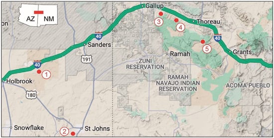
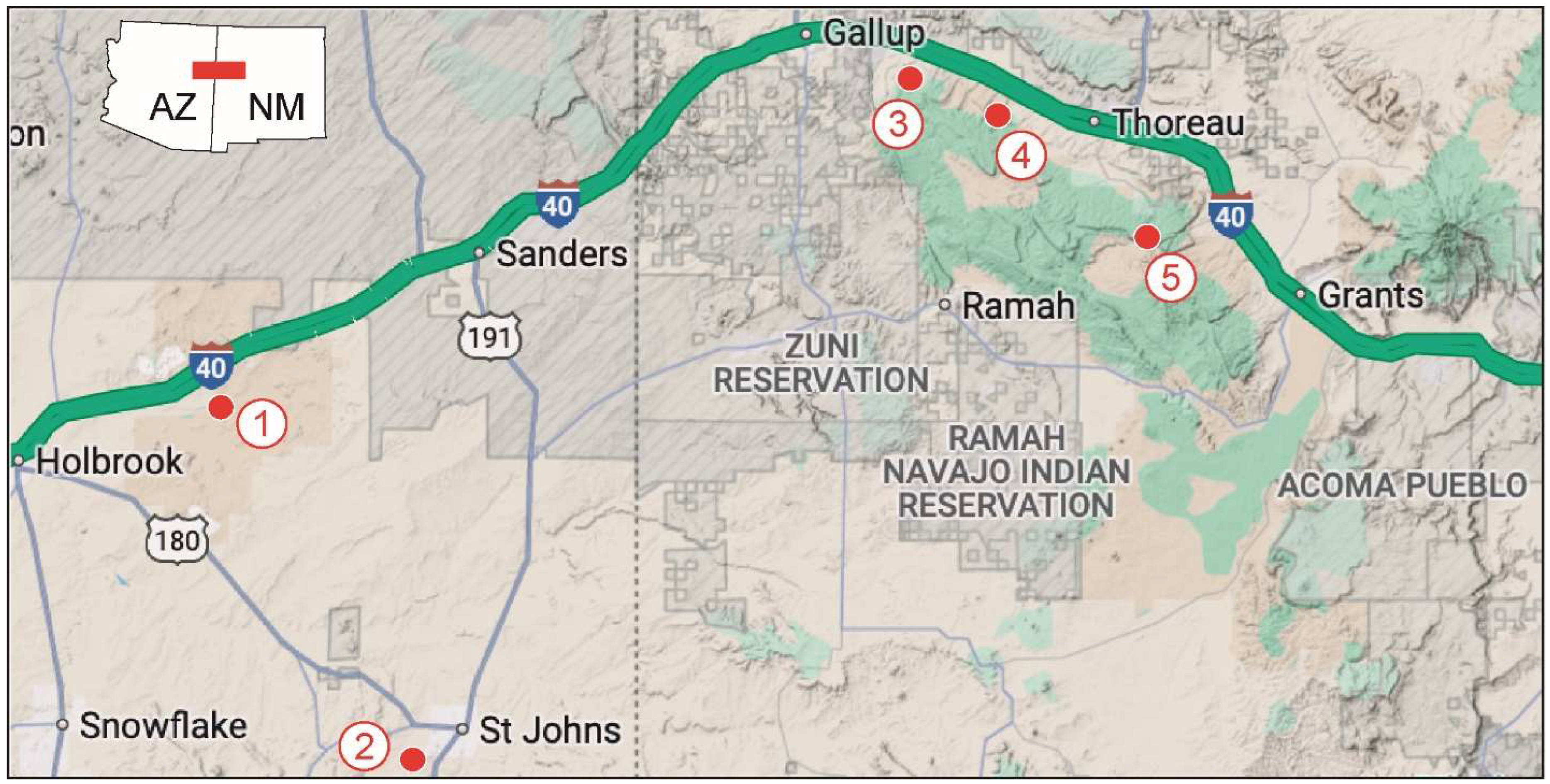
Figure 1.
Map of part of east-central Arizona and west-central New Mexico, USA, showing the main localities mentioned in the text. Localities are 1 = Petrified Forest National Park (PEFO); 2 = Placerias quarry; 3 = Fort Wingate; 4 = Sixmile Canyon; 5 = Bluewater Creek. Base map from Google Maps.

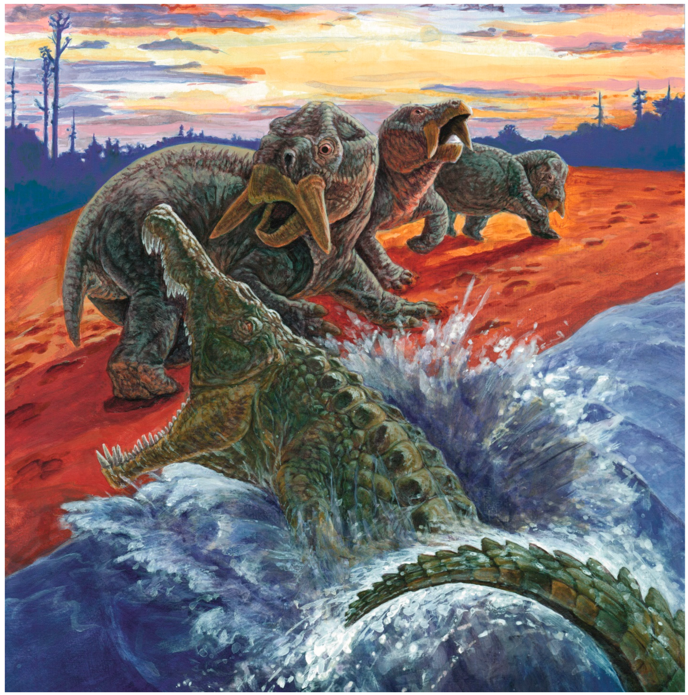
Figure 2.
Group of dicynodonts of the genus Placerias attacked by a phytosaur. Artwork by Matt Celeskey.
Placerias was a large dicynodont with a total body length of about 3.4 m and an estimate weight of about 1000 kg. This large herbivore was one of the last dicynodonts. It is primarily (and perhaps exclusively) known from the Placerias quarry, where the remains of about 40 individuals were collected. Other possible records of Placerias are from North Carolina and Morocco and merit further research.
From its initial publication, diverse authors located the Placerias quarry stratigraphically low in the Chinle Group section, and biostratigraphy indicates it is about 225–230 Ma [3,8]. However, Ramezani et al. [9] published U/Pb ages on detrital zircons from the quarry to suggest it is much younger, about 219 Ma, and thus much higher stratigraphically in the Chinle section. Indeed, based on the U/Pb ages of the Placerias quarry strata and lower Chinle strata to the east, Ramezani et al. [9] reorganized the local and regional Chinle Group lithostratigraphy to indicate major lithofacies changes over lateral distances of a few km to tens of km (also see [10,11]). Here, I review already published data and present new data and analysis that support a stratigraphic position of the Placerias quarry very low in the Chinle Group. This calls into question the numerical ages published by Ramezani et al. [9] and leads to the conclusion that numerical ages need to be interpreted within the framework of well-established lithostratigraphy and biostratigraphy.
2. Previous Stratigraphic Observations on the Placerias Quarry
The Placerias quarry is located in east-central Arizona about 10 km southwest of St. Johns near the southern edge of the Colorado Plateau (sec. 14, T12N. R27E; UTM zone 12, 641445E, 3812105N, NAD 83) (Figure 1 and Figure 3). Camp and Welles [4] (p. 258) first published stratigraphic observations on the Placerias quarry, noting that “the hills in the area are obscure, weathered, and overgrown with grass, low shrubs, and junipers, so it was impossible to measure an accurate stratigraphic section to connect with the base of the Chinle at the Moenkopi and Shinarump outcrops 3 miles east”. They then stated that “the best stratigraphic guide is the presence in the quarry of the broad squamosals of the St. Johns phytosaur, Machaeroprosopus zunii, which occurs a few miles away within 15 to 100 ft [5 to 30 m] of the base of the lower Chinle” (pp. 238–239). Earlier, Camp et al. [12] indicated that the Placerias quarry was stratigraphically low in the Chinle section.
Jacobs and Murry [13] (p. 56), largely based on the mapping of Akers [14], stated that “the Placerias quarry is in the Petrified Forest Member, low in the Chinle”, and Long and Padian [15] also advocated that stratigraphic position. Jacobs and Murry [13] also reported another vertebrate-fossil locality they called the Downs quarry, which is ~72 m east of the Placerias quarry and at approximately the same stratigraphic level (the Placerias and Downs quarries occupy a stratigraphic interval a couple of meters thick [16]). Tannenbaum [17] and Kaye and Padian [18] (p. 193) noted that the microfauna they described from the Placerias–Downs quarry complex is most similar to the microfauna Murry [19] described from low in the Chinle in the Petrified Forest National Park and concluded that “this observation is consistent with the low placement of the Placerias quarry in the Petrified Forest Member, as noted by previous workers.” Murry and Long [20] and Long and Murry [7] followed earlier workers in assigning the Placerias quarry to a stratigraphic position low in the Chinle section.
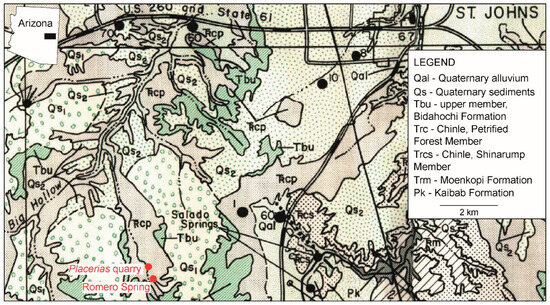
Figure 3.
Geologic map of the St Johns-Placerias quarry area in Arizona, modified from [14].
Figure 3.
Geologic map of the St Johns-Placerias quarry area in Arizona, modified from [14].

Lucas et al. [8] presented the first actual lithostratigraphic evaluation of the stratigraphic position of the Placerias quarry. They concluded that the quarry is very near the base of the Bluewater Creek Formation, which is nearly at the base of the Chinle section (also see [21]). However, some later workers [9,10,22] have assigned the Placerias quarry a much higher stratigraphic position in the Chinle section, based either on their lithostratigraphic interpretations or on U/Pb ages on tuffaceous and detrital zircons (DZ).
Here, I apply surface and subsurface stratigraphic data to reaffirm a stratigraphic position of the Placerias quarry very low in the Chinle section. I also review the discordance between some of the published U/Pb ages on Chinle zircons to argue that such ages need to be placed in the well-established lithostratigraphic framework, not used to overturn that framework.
3. Permo-Triassic Stratigraphy Around the Placerias Quarry
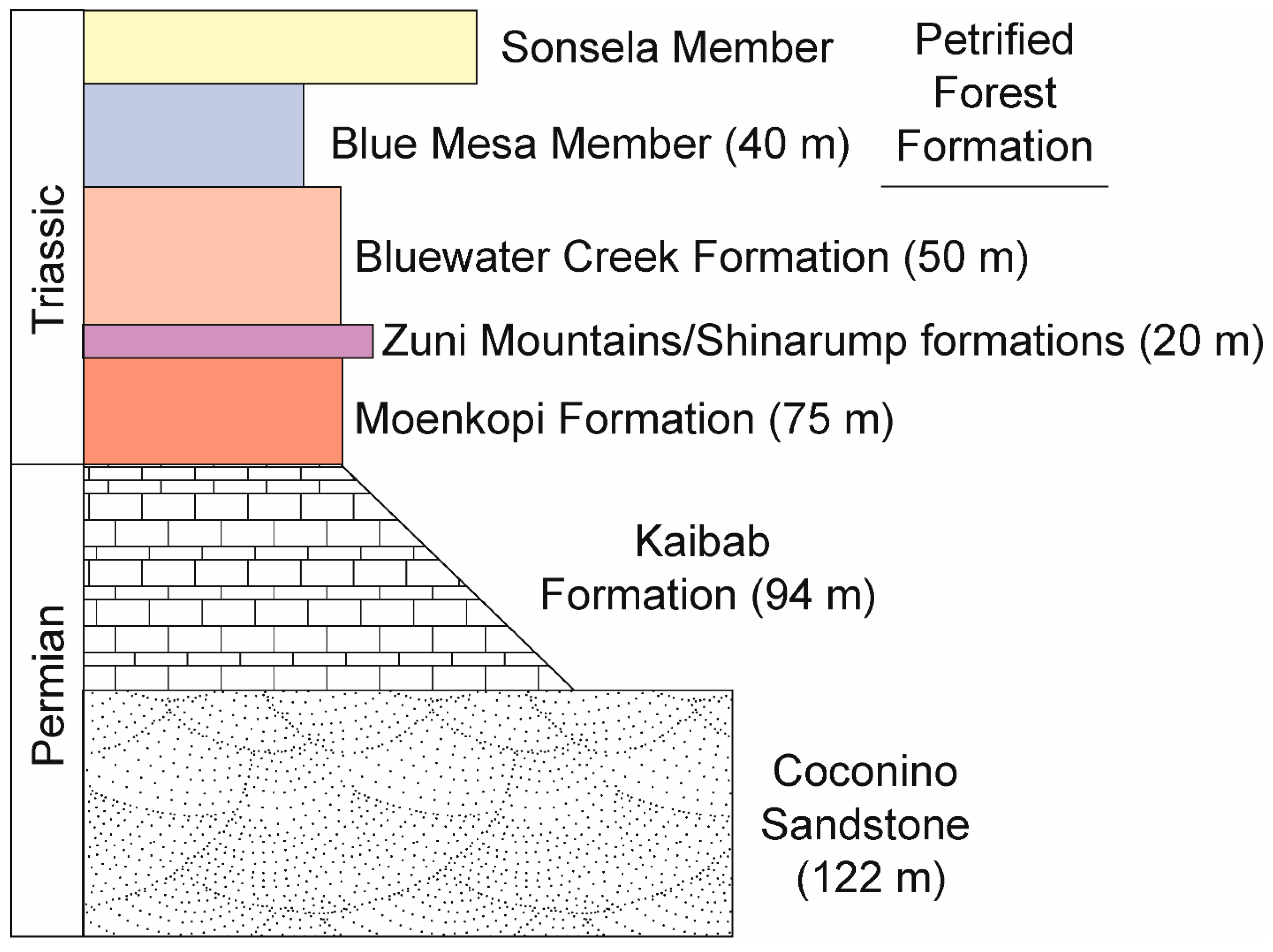
In east-central Arizona, in the area around the St. Johns, which encompasses the Placerias quarry and vicinity, Permian and Triassic strata in the subsurface and at the surface are relevant to the stratigraphic position of the quarry (Figure 4). The relevant subsurface units begin with the Coconino Sandstone, a lower Permian eolianite that is mostly crossbedded, quartzose sandstone that is up to 122 m (400 ft) thick. It is locally and intermittently overlain by the lower-middle Permian Kaibab Formation, primarily limestone, that is up to 94 m (310 ft) thick but also locally absent. These Permian strata are the principal aquifers in the area around the Placerias Quarry [14,23,24].
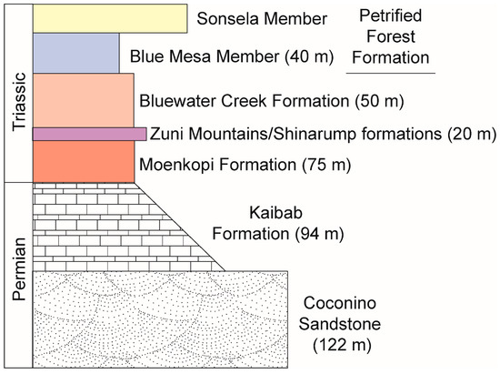
Figure 4.
Generalized stratigraphic section of subsurface (Coconino, Kaibab and Moenkopi formations) and surface (lower Chinle Group strata) lithostratigraphic units in the Placerias quarry area with maximum unit thicknesses indicated (based primarily on [14,21,25,26,27,28,29,30,31].
A substantial unconformity separates the Permian strata from the overlying Triassic Moenkopi Formation, which is as much as 75 m (229 ft) of red bed mudstone, lesser sandstone and minor conglomerate [25,26,27,28]. The Placerias quarry is east of the pinchout of the lower (Wupatki) and middle (Moqui) members of the Moenkopi Formation in eastern Arizona, so the entire Moenkopi Formation in the St. Johns area is the Holbrook Member. Reported thicknesses of the Moenkopi Formation in the area of the Placerias quarry range from as little as 15 m to a maximum of 75 m [25,26,27,28]. Another unconformity separates Moenkopi strata from the overlying base of the Chinle Group. The great variation in Moenkopi thickness is likely due to erosion and paleotopography associated with its bounding unconformities.
Above the Moenkopi Formation, four Chinle Group formations are present (ascending): Zuni Mountains Formation (“mottled strata”), Shinarump, Bluewater Creek and Petrified Forest formations [21,26,27,29,30,31] (Figure 4). The Shinarump Formation is quartz sandstone and siliceous conglomerate up to 20 m thick and only present locally. Where it is not present, the lowermost Chinle strata are assigned to the Zuni Mountains Formation (“mottled strata” of [29]). The Zuni Mountains Formation is largely a stack of paleosols represented by purple sandy mudrock with kaolinitic intervals and numerous rhizoliths, and can be up to 25 m thick but is usually thinner, 1.5–8 m thick [29]. Locations where Shinarump strata are present represent channel fills at the onset of Chinle deposition and are laterally equivalent to (though not necessarily temporally equivalent to) Zuni Mountains Formation strata that were deposited on the interfluves between the Shinarump channels [29,31,32].
The Zuni Mountains/Shinarump interval is overlain by a mudrock-dominated interval that is primarily red beds, the Bluewater Creek Formation, which is up to 50 m thick. The overlying Petrified Forest Formation consists of three members (ascending): Blue Mesa, Sonsela and Painted Desert. The Blue Mesa Member is primarily blue, purple and green bentonitic mudstone up to 40 m thick. The Sonsela is two sheets of conglomerate/sandstone divided by a more muddy interval. The Painted Desert Member is red beds, but not relevant to the discussion here.
All workers agree that the Placerias quarry is of Late Triassic age and in the Chinle Group section. Precise placement in that section can be made based on surface and subsurface stratigraphic data, and that placement is supported by regional lithostratigraphy and biostratigraphy.
4. Surface Stratigraphy at the Placerias Quarry
Despite the comments of some early workers (see above), there are significant Chinle outcrops at and near the Placerias quarry (Figure 5, Figure 6, Figure 7 and Figure 8). These outcrops are essentially flat lying except for an interval where there is some low amplitude folding of the Chinle strata (see below). Akers [14] mapped the geology around the Quarry (Figure 3) and located it in what he called the Petrified Forest Member of the Chinle Formation, a unit that encompassed all of the Chinle strata between the Shinarump and Owl Rock members. About 8 km to the west-southwest of the Placerias quarry, Akers [14] mapped a Moenkopi–Chinle contact at about 6000 ft (1858 m) altitude, which, within resolution, is the altitude of the Placerias quarry [8] (Figure 2). About 5 km east of the Placerias Quarry at approximately the same elevation on strike, around Salado Spring the contact of the basal Chinle Shinarump Formation over Moenkopi Formation crops out (Figure 3), which also suggests that the Placerias quarry is close to the Chinle–Moenkopi contact. Wilson et al. [33], in a bedrock geology map of Apache County, Arizona, at a scale of 1: 375,000, also mapped that Moenkopi–Chinle contact outcrop, as did Akers, and mapped most of the area for several km around the Placerias quarry as Chinle Formation.
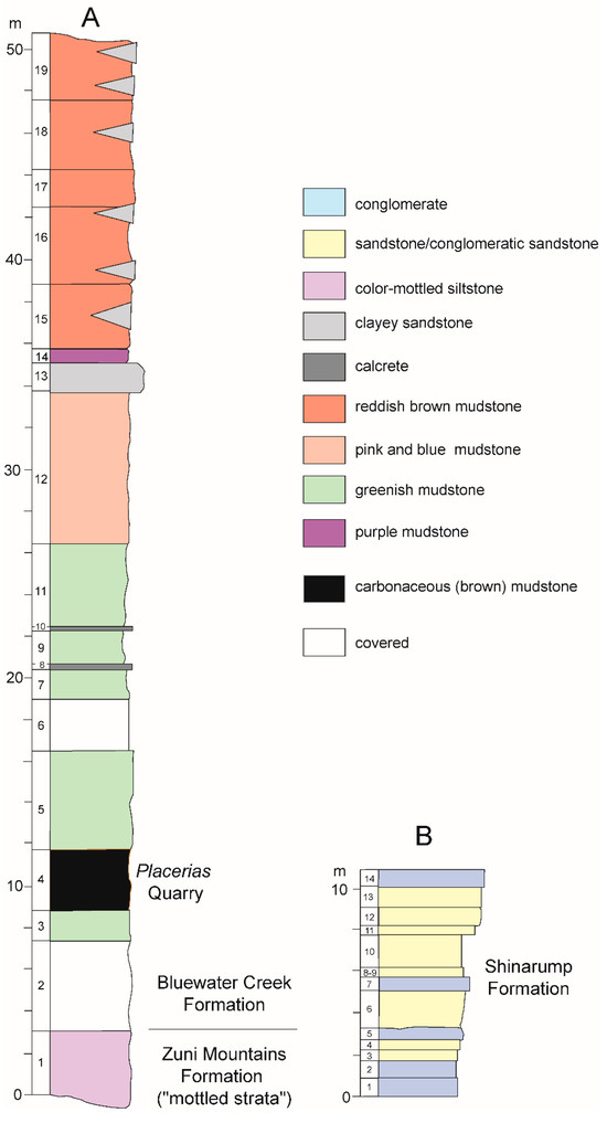
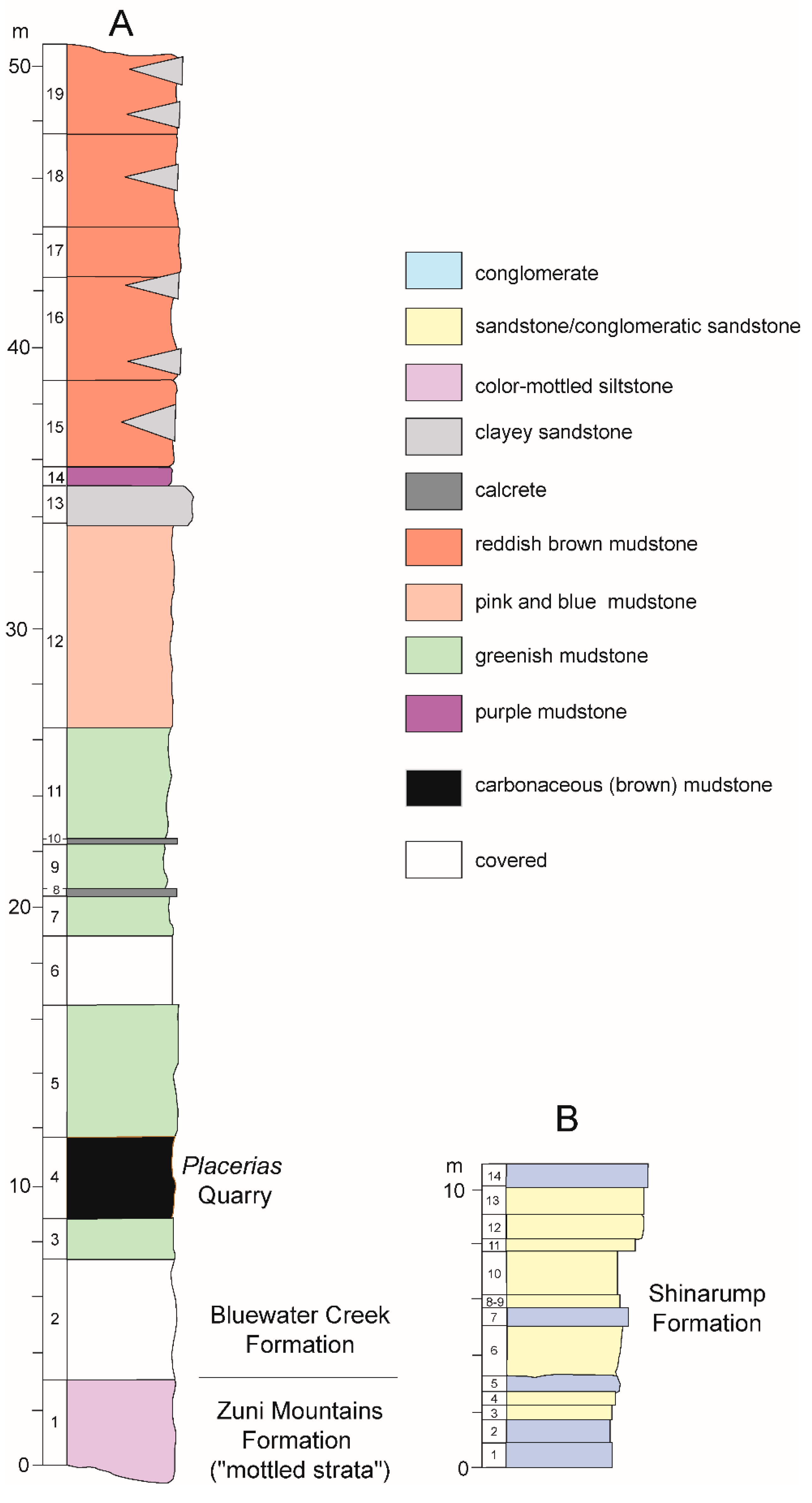
Figure 5.
Measured stratigraphic sections at and in the vicinity of the Placerias quarry. (A) is the stratigraphic section at the quarry and of the outcrops to the northeast. (B) is the stratigraphic section of the slumped block of Shinarump Formation. See text for further discussion.

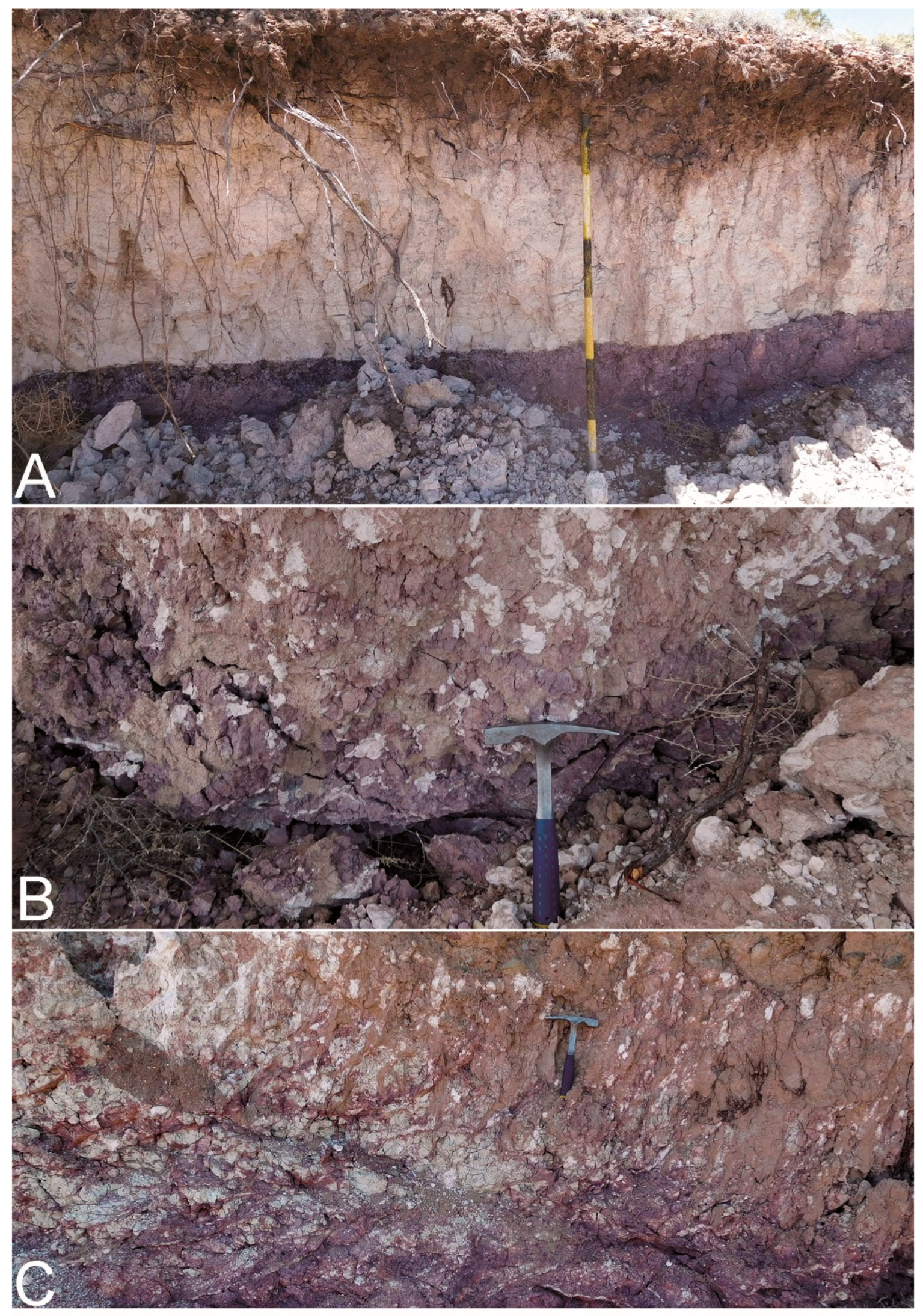
Figure 6.
Zuni Mountains Formation (“mottled strata”) outcrops just northwest of the Placerias quarry at UTM zone 12, 641245E, 3811618N. (A) Bluish siltstone overlain by heavily kaolinized horizon. (B) Siltstone with rhizoliths and breccia pieces of kaolinite. (C) Various rhizoliths and nodules in siltstone.

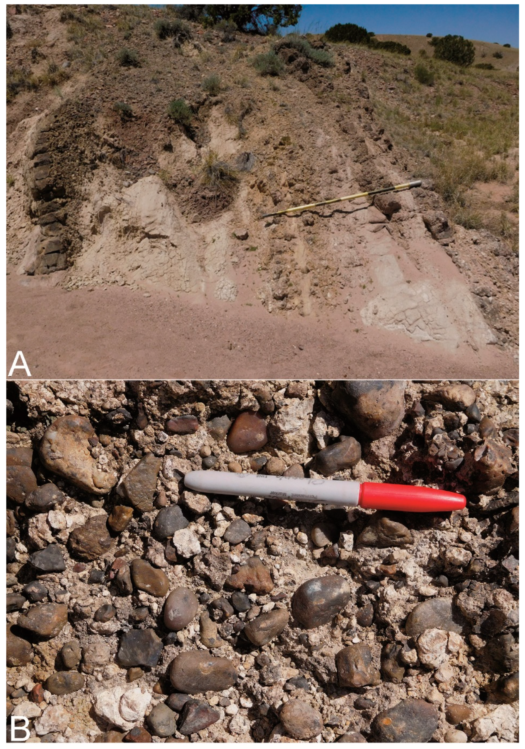
Figure 7.
Faulted outcrop of Shinarump Formation near the Placerias quarry (UTM zone 12, 641134E, 3812559N). (A) Overview of Shinarump Formation and sandstones steeply dipping to the SE. (B) Closeup photograph of siliceous pebbles in conglomerate.

Figure 8.
Chinle Group outcrops immediately to the northeast of the Placerias quarry. These are red beds of the Bluewater Creek Formation. (A) Overview. (B) Closeup of conical hill on upper left in (A). In (A), note that “c” in the lower right is the carbonaceous mudstone that hosts the Placerias quarry (Figure 5, unit 4 in stratigraphic section (A)).
Since the 1990s, when Lucas et al. [8] made their stratigraphic observations, erosion coupled with further examination on the outcrop makes a definitive conclusion about the lithostratigraphic position of the Placerias quarry possible, one that supports the conclusion of Lucas et al. [8] that the quarry is close to the Chinle base. Most significant has been cut bank failure in the arroyo about 600 m northwest of the Placerias quarry at UTM 12, 641245E, 3811618N (datum NAD 83). This has exposed 2–3 m of grayish purple and white, color mottled silty and sandy mudstone with white kaolinitic lenses and interbeds as well as numerous rhizoliths in some beds (Figure 5 and Figure 6). Some grayish-red chert pebbles are dispersed in the siltstone as are thin lenses of white to very light gray sandstone. These are lithotypes characteristic of and restricted to the Zuni Mountains Formation (“mottled strata”) at the Chinle base on the southern Colorado Plateau [21,29,32,34]. An outcrop of these “mottled strata” at UTM 641345E, 3811782N is about 300 m northwest of the Placerias Quarry and is at the base of stratigraphic section A in Figure 5 and was also at the base of the Romero Spring stratigraphic section of [9] Figure 3 (also see [8] Figure 4).
Not far northwest of the Placerias quarry, at UTM zone 12, 641134E, 3812559 (NAD 83), there is a faulted outcrop of the Shinarump Formation in the nearby tributary of Big Hollow Wash (Figure 5 and Figure 7). Here, the exposed Shinarump strata are about 11 m thick, and beds are nearly vertical. Most of the beds are conglomerate or conglomeratic sandstone that are pinkish-gray, light brownish-gray and olive-gray. Clasts are red, black and gray chert and irregular-shaped pinkish gray limestone (likely calcrete nodules) up to about 2.5 cm in diameter in a coarse sandstone matrix. Sandstone beds are yellowish gray, coarse grained and crossbedded. The presence of this Shinarump outcrop, though faulted, indicates proximity to the Chinle base, where the Shinarump is locally present [8,14,21,26,27]. If the Placerias quarry is, as claimed by some workers, in the upper Blue Mesa or Sonsela interval, then it would be about 100 m above the local Chinle base (see below). This would require a reverse fault of substantial magnitude to bring the Shinarump to the surface near the Placerias Quarry, and no such reverse faults have been identified in the area (see, for example, mapping by [14]).
A covered interval 4.5 m thick is above the Zuni Mountains Formation, overlain by greenish-gray mudstone that contains some yellowish gray gypsum nodules (Figure 5). The overlying 2.5–3 m of pale brown and light brown, carbonaceous mudstone host the Placerias quarry vertebrate fossils. About 4.5 m of pale green and light brown mudstone overlie this bone-bearing unit, and are overlain by variegated green and purple mudstone with calcrete nodules and two thin (0.1 m thick) ledges of nodular calcrete.
To the northeast of the Placerias quarry, the outcrop continues, and there is no fault here, just some low amplitude folding of the strata (Figure 8). This folding is likely the local expression of the syndepositional slumping seen in this interval of the lower Bluewater Creek Formation in the Blue Hills near St. Johns [21,35,36] and in New Mexico near Fort Wingate [36,37]. There is no faulting in the stratigraphic section, and the folding is of low amplitude and does not structurally disrupt the stratigraphic section. Thus, stratigraphic section A (Figure 5) is a homoclinal stratigraphic section of Chinle strata, as was also concluded by [9] and is evident in the geologic mapping (Figure 3) by Akers [14].
Therefore, I have concluded, as have others, that the outcrops to the northeast are part of the same stratigraphic succession as the Placerias quarry (Figure 5 and Figure 8), overlying the green-brown mudstones that characterize the bone-bearing strata (as did [9] Figure 4, who also measured this red-bed-mudrock-dominated stratigraphic interval). These overlying strata are about 28 m thick and are mostly mudstone that is variegated reddish brown, purple and pink. One prominent bed and lenses of white sandstone/clayey sandstone are common in the upper part of this succession (Figure 5 and Figure 8). These strata are readily assigned to the Bluewater Creek Formation [8,21,32,34,38] based on stratigraphic position and lithology.
However, Parker [10], p. 3 stated that “lithostratigraphic correlation from Petrified Forest National Park, 62 km northwest of the [Placerias] quarry demonstrates that the quarry is located in the uppermost portion of the Blue Mesa Member or in the lowermost portion of the Sonsela Member (Parker and Martz, 2011; Irmis et al., 2011; W.G. Parker and J.W. Martz, 2010, unpublished data)” and that “red beds above the quarry level assigned to the Bluewater Creek Member of the Chinle Formation (Lucas, Heckert and Hunt, 1997 [8]) are actually deposits of the Miocene-Pliocene Bidahochi Formation separated from the Chinle Formation by angular unconformities (Akers, 1964; W.G. Parker & J.W. Martz, 2008, unpublished data)”. Nevertheless, these statements are both erroneous and misleading:
- Parker and Martz [39] and Irmis et al. [40] presented no lithostratigraphic correlation between the Petrified Forest National Park (PEFO) and the Placerias quarry. The correlation advocated by Parker [10] matches dis-similar lithostratigraphic units to each other and contradicts the well-established regional Chinle lithostratigraphy (see later discussion).
- Akers [14] (pl. 3) mapped the red beds just northeast of the Placerias Quarry as Chinle Formation, not Bidahochi Formation (Figure 3). He did map a small outcrop of the upper member of the Bidahochi Formation around part of the western margin of the upland surface northeast of the quarry and above the red beds (Figure 3). The upper member of the Bidahochi Formation is yellowish-gray silty travertine intercalated with lenticular beds of sandstone and siltstone [14,41,42], very different from the Chinle red beds exposed immediately to the northeast of the Placerias quarry.
Furthermore, the red beds northeast of the Placerias Quarry are not separated by angular unconformities from underlying Upper Triassic strata nor do they include the characteristic conglomerate found at the base of the Bidahochi Formation [14,41]. The lower member of the Bidahochi Formation does include some red beds similar to Chinle red beds, but it is generally a variegated gray, brown, pink and green unit of mudstone, siltstone and sandstone with a few volcanic ash beds. And, the lower member is not present south of a latitude north of St. Johns as it was truncated southward by a Quaternary erosion surface so that the upper member of the Bidahochi is the oldest part of the formation in the St. Johns-Placerias quarry area [14] (Figure 3).
- 3.
- As already noted, Ramezani et al. [9] measured the red bed section above the Placerias quarry, and their section (“Romero Spring”) is very similar to mine in lithologic succession and thickness. From a level ~20 m stratigraphically above the Placerias quarry they reported a U/Pb age on DZ of ~218 Ma (this is in bed 12 of section A in Figure 4), which is not a Miocene-Pliocene age.
A stratigraphic succession similar to that at the Placerias quarry has been documented to the northeast, at the Blue Hills north of St. Johns in Arizona, and in west-central New Mexico, near Fort Wingate and in Sixmile Canyon (Figure 1). Near Fort Wingate, the “Ciniza lake beds” of Ash [37] at the base of the Bluewater Creek Formation are remarkably similar to the strata that host the Placerias quarry—brown carbonaceous mudstone and green mudstone with nodular calcrete about 5–6 m thick [32,34]. Similar carbonaceous and green mudrocks are present in the Monitor Butte Formation near the Chinle Group base in southeastern Utah [43,44,45]. Indeed, Dubiel et al. [36] assigned these strata at Fort Wingate and similar strata in the Blue Hills near St. Johns to the Monitor Butte Formation.
These strata are generally interpreted as lacustrine deposits [36,37], though Fiorillo et al. [5] considered the Placerias quarry to be in a palustrine deposit of pedogenically modified floodplain mudrock. No dicynodont bones are present in these strata in the Blue Hills, but near Fort Wingate the “lake beds” have abundant dicynodont coprolites [46,47]. Indeed, such carbonaceous beds are limited to strata very low in the Chinle Group section [1,29,43,44,45]. Given the rarity of carbonaceous mudrock and its restriction to strata very low in the Chinle Group [1], the presence of this lithotype at the Placerias quarry, Fort Wingate and at Sixmile Canyon suggests a correlation as well as a correlation to part of the Monitor Butte Formation of southeastern Utah, which is near the base of the Chinle section there [1,29,43,44]. In all of these places, the carbonaceous beds are very low in the Chinle section near the base of the Bluewater Creek Formation. Furthermore, as Lucas and Tanner [48] argued, these carbonaceous and lacustrine facies are associated with “wet paleosols” and thus are likely indicative of the well know pluvial episode of Carnian age.
Thus, the surface lithostratigraphy at the Placerias quarry places it stratigraphically low in the Chinle section, very low in the Bluewater Creek Formation not far above the Zuni Mountains Formation (as was also concluded by [8]). Correlation to similar stratigraphic successions to the east, in the Blue Hills near St. Johns, Arizona and near Fort Wingate and in Sixmile Canyon in New Mexico, supports that stratigraphic placement of the Placerias quarry.
5. Subsurface Stratigraphy at the Placerias Quarry
Another way to establish the stratigraphic position of the Placerias quarry that has not been used before is to examine subsurface water well data, which is extensive in the St. Johns area [14,23,24]. These data show that the aquifer being tapped around the Placerias quarry is in the Permian Coconino Sandstone and/or Permian Kaibab Formation (Figure 4). The depth to water in this Permian aquifer is a way to estimate approximately how much Triassic section is above the aquifer and in the subsurface below the Placerias quarry stratigraphic level.
From these sources [14,23,24], the following points are clear:
- Water wells drilled in the vicinity of the Placerias quarry are drawing water primarily from the Permian Coconino Sandstone, though some water may be coming from the Permian Kaibab Formation.
- In the vicinity of the Placerias Quarry, the potentiometric contour (altitude at which water level would have stood in a tightly cased well) is close to 5900 ft above MSL (mean sea level) (Figure 3). Akers [14] (pl. 3) shows it above 5800 ft, close to 5900 ft, Harper and Anderson [23] show it between 5800 and 5900 ft, and Mann and Nemecek [24] (pl. 3) locate the Placerias quarry as between the 5900 and 6000 contours. I thus consider the potentiometric contour at the Placerias quarry to be approximately 5900 ft.
- Depth to water in wells drilled near the Placerias Quarry is relatively shallow, 100 ft (30 m) or less. At the well nearest to the Placerias Quarry at Romero Springs (A-12-27-4 of [24]) the depth to water is only 10 ft (3 m) or less, as this is a spring at the surface. A well 1 mile (1.6 km) to the south (12-27-23 of [24]) has a depth to water of 100 ft (30 m), and a well 1 mile (1.6 km) east-southeast has a depth to water of 32 ft (10 m) (well 32/5893/3240 of [23] pl. 1). A well 1.5 miles (2.4 km) to the east-southeast has a depth to water of 75 ft (23 m) (well 75R/5845/1350 of [23] pl. 1). These last two wells have potentiometric contours of 5893 and 5845 ft, respectively. A water well about 1.25 miles (2 km) northeast of the Placerias quarry in Akers [14] (well 1—see Figure 3) has depth to water of 60 ft at 5900 ft. Data and locations on these and other wells in the area of St. Johns and the Placerias Quarry are compiled by Akers, Harper and Anderson and Mann and Nemeck [14,23,24].
- This indicates that there are approximately 100 ft (30 m) or less of post-Permian strata between the water in the Permian aquifer and the land surface at the Placerias Quarry, which is at about 6000 ft above MSL. Moenkopi thickness locally can be up to 75 m (see above), which would easily account for all of the subsurface Triassic thickness. There is certainly not a substantial section of Chinle Group strata in the subsurface.
- Note that one imprecision here is how deep into the Permian strata were the water wells drilled to encounter water. This means that at least some of the depth to water locally may include Permian strata, which reduces the potential thickness of the Triassic strata in the subsurface beneath the Placerias Quarry. In other words, 30 m is a maximum Triassic thickness in the subsurface, and it may be well less than that.
To resolve the stratigraphic position of the Placerias quarry in the Chinle section, Bagley et al. [49] used a surface direct current electrical resistivity (likely a 1D analysis, though that was not stated) to estimate what sediments were in the subsurface below the Placerias quarry. According to their results, there is no detectable lithological change (based on resistivity) to a depth of 50 m below the quarry. This contradicts the water well data, which suggests a substantial change in lithology at the top of the subsurface Permian strata (see Figure 4). Bagley et al. [49] concluded that “our results therefore indicate that the higher stratigraphic position [of the Placerias quarry], in the Blue Mesa Member, is most likely correct…” However, this method, especially when it is a 1D analysis, does not readily distinguish thin strata or strata of similar resistivity to adjacent strata, and it cannot give unique solutions for both thickness and resistivity [50]. Thus, Seidel and Lange [50] (p. 212) noted that “it is important to correlate resistivity sounding data with data from boreholes in the area of investigation”. Clearly Bagley et al. did not have access to boreholes to evaluate their resistivity analysis. Their conclusion that 50 m of Triassic strata underneath the surface would place the Placerias quarry in the Blue Mesa Member interval thus is inconsistent with water well data and based on an analysis that uses a crude tool of questionable value unless checked against borehole data.
6. Chinle Stratigraphy in East-Central Arizona and West-Central New Mexico
There is a consistent lithostratigraphic architecture of the lower Chinle Group section from the Petrified Forest National Park in Arizona to the Bluewater Creek area near Grants in New Mexico, a transect of ~195 km (Figure 9). This is not surprising as the transect is nearly perpendicular to depositional dip in a very large depositional system [1,51,52]. Across this transect, Chinle Group strata rest disconformably on strata of the Moenkopi Formation. The Chinle succession is as follows:
- Shinarump and Zuni Mountains formations, siliceous sandstones and conglomerates (Shinarump) and color mottled mudrock with rhizoliths and other evidence of pedogenesis (Zuni Mountains).
- An interval of red beds, mostly mudstone dominated, referred to by various workers under different names: lower part or all of lower Petrified Forest Member, lower red member, Monitor Butte Member, Mesa Redondo Member or Bluewater Creek Formation. For reasons presented by Lucas [1] and Heckert and Lucas [21,32,38], I refer to these strata by one name, Bluewater Creek Formation. The Bluewater Creek Formation to the east (particularly near St. Johns and Fort Wingate, New Mexico), has a relatively thin (less than 10 m thick) lower interval of greenish mudstone and carbonaceous clay/lignite that is overlain by the red beds that make up the bulk of the formation [32]. This is precisely the lithologic succession of Bluewater Creek strata in the vicinity of the Placerias Quarry.
At PEFO, this unit, primarily in a subsurface core, is about 30 m thick [53,54] but it is not clear if the Zuni Mountains Formation is present at the base of the Chinle Group section in the core (also see [55]). Water well data identify the Shinarump and Zuni Mountains formations in the subsurface near PEFO [38,56,57]. And, about 1.5 m of Zuni Mountains Formation strata crop out at the base of the Chinle section about 10 km WNW of the southern part of PEFO [57].
- 3.
- Blue Mesa Member of Petrified Forest Formation, a succession of bentonitic mudstones that are blue-gray-purple, green and white with some thin sandstone interbeds and calcretes [1].
- 4.
- Sonsela Member of Petrified Forest Formation, a conglomerate- and sandstone-dominated interval with a scour base with up to 7 m of local relief [58]. Continuity of this sharp basal contact is one of the reasons that the Sonsela base has been identified as a regional unconformity [1,59], though the hiatus associated with this unconformity may be geologically short. The Sonsela is usually two conglomerate/sandstone sheets divided by a medial mudrock interval. The lower Sonsela sheet is more conglomeratic than the upper sheet. The conglomerates are both intrabasinal (mudstone and calcrete rip ups) and extrabasinal (siliceous clasts). Petrified logs are common.

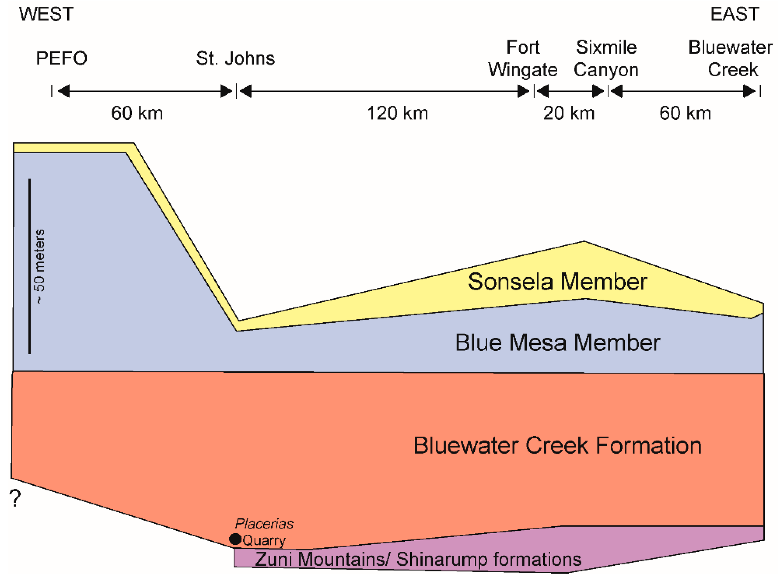
Figure 9.
Simplified lithostratigraphic cross section from the Petrified Forest National Park (PEFO) in Arizona to Bluewater Creek in New Mexico. Modified from [59] and based largely on data in [31,32]. Note that the presence of Zuni Mountains/Shinarump formations in the subsurface at PEFO is uncertain. Stratigraphic position of the Placerias quarry indicated in the St. Johns area. The “?” indicates the lack of detailed subsurface stratigraphic data at PEFO.
The Sonsela Member represents a significant change in deposition from floodplain deposition of the underlying Blue Mesa Member to that of an extensive braidplain [58]. The lower Sonsela is conglomeratic, whereas the upper Sonsela is finer grained, sandstone dominated. However, no stratigrapher or mapper has reported evidence of intertonguing of the Sonsela with underlying strata. As Repenning et al. [60] (p. B21) noted, “the Sonsela is an excellent datum for mapping, tracing, and correlating the units of the Chinle Formation.”
This lithostratigraphic succession been recognized for about a century in various portions of this transect or across all of it in east-central Arizona and west-central New Mexico by diverse workers doing stratigraphic work and geologic mapping (e.g., [12,14,21,22,27,28,30,32,34,36,38,57,60,61,62,63,64,65,66,67,68,69,70,71,72,73,74,75,76,77,78,79,80,81,82]. Recent efforts to modify this lithostratigraphy have been made based on lithostratigraphic errors [10] or on discordant numerical ages [9].
7. Biostratigraphy of the Placerias Quarry
Note here that I do not use the “long Norian” used by many workers but instead the “short Norian” of Lucas et al. [83] by which the Carnian–Norian boundary is about 221 Ma, and the Otischalkian and Adamanian land-vertebrate faunachrons (LVFs) are Carnian in age. I also point out different usage by other workers, who generally term Norian strata that I identify as late Carnian. This is an essential piece of book keeping here but not critical to the correlations being advocated.
Previous workers have correlated the vertebrate-fossil assemblage at the Placerias quarry to similar vertebrate fossil assemblages found stratigraphically low in the Chinle Group, especially in the Petrified Forest National Park [4,7,15,17,18,81]. Lucas et al. [8] regarded the Placerias quarry as very close to the beginning of the Adamanian LVF because it contains the characteristic Otischalkian phytosaur Parasuchus (=Paleorhinus) and Adamanian index taxa such as the phytosaur Rutiodon and the aetosaurs Stagonolepis (=Calyptosuchus) and Desmatosuchus (also see [3]). I continue to advocate an early Adamanian age for the Placerias quarry, which is a late Carnian age [3,83].
Kozur and Weems [84] correlated the conchostracans from the “Ciniza lake beds” near Fort Wingate, New Mexico, to Newark Supergroup and German Keuper conchostracans to conclude they indicate a late Carnian (Tuvalian) age. Palynomorphs and megafossil plants of the lower Chinle Group, including localities at Fort Wingate, New Mexico, indicate a Carnian age [85,86,87]. Thus, biostratigraphy indicates a Carnian age for the Placerias quarry close to the Otischalkian–Adamanian LVF boundary, and this is an age close to the early-late Carnian (Julian-Tuvalian) boundary [3].
8. Numerical Ages and Chinle Group Lithostratigraphy
Having established the lithostratigraphic position and biostratigraphic age of the Placerias quarry, it is surprising that Ramezani et al. [9] published a numerical age of ~219 Ma for the quarry. By the current Triassic timescale, the quarry should be substantially older, close to the numerical age of the Julian–Tuvalian boundary, which has numerical age control indicating it is close in age to 230.9 Ma [88,89]. Furthermore, the Placerias quarry is stratigraphically below ages older than 219 Ma already published by Ramezani et al. [9,90] and others.
There are numerous published U-Pb ages for lower Chinle Group l zircons in east-central Arizona-west-central New Mexico [9,11,40,53,90,91,92,93,94]. Most of these ages are concentrated in PEFO where the dates have been on zircons on outcrop and in core. These ages encompass the lower Chinle Group section, but the ages from outcrop samples [9,53] and from core samples [92,93,94] are not entirely consistent, particularly the ages from coarser-grained beds. Nevertheless, there is enough overlap in the ages to conclude the following:
- The Bluewater Creek strata at the base of the Chinle Group section in PEFO are 223–227 Ma. This is consistent with DZ ages of 225–234 Ma from the Shinarump Formation outside of PEFO [91].
- Blue Mesa Member strata range in age from 216 to 222 Ma.
- Sonsela Member strata range in age from 213 to 221 Ma; the overlap with some Blue Mesa ages reflects the inconsistency between the surface and subsurface ages. Dickinson and Gehrels [91] published an age range of 208 to 229 Ma for the Sonsela Member.
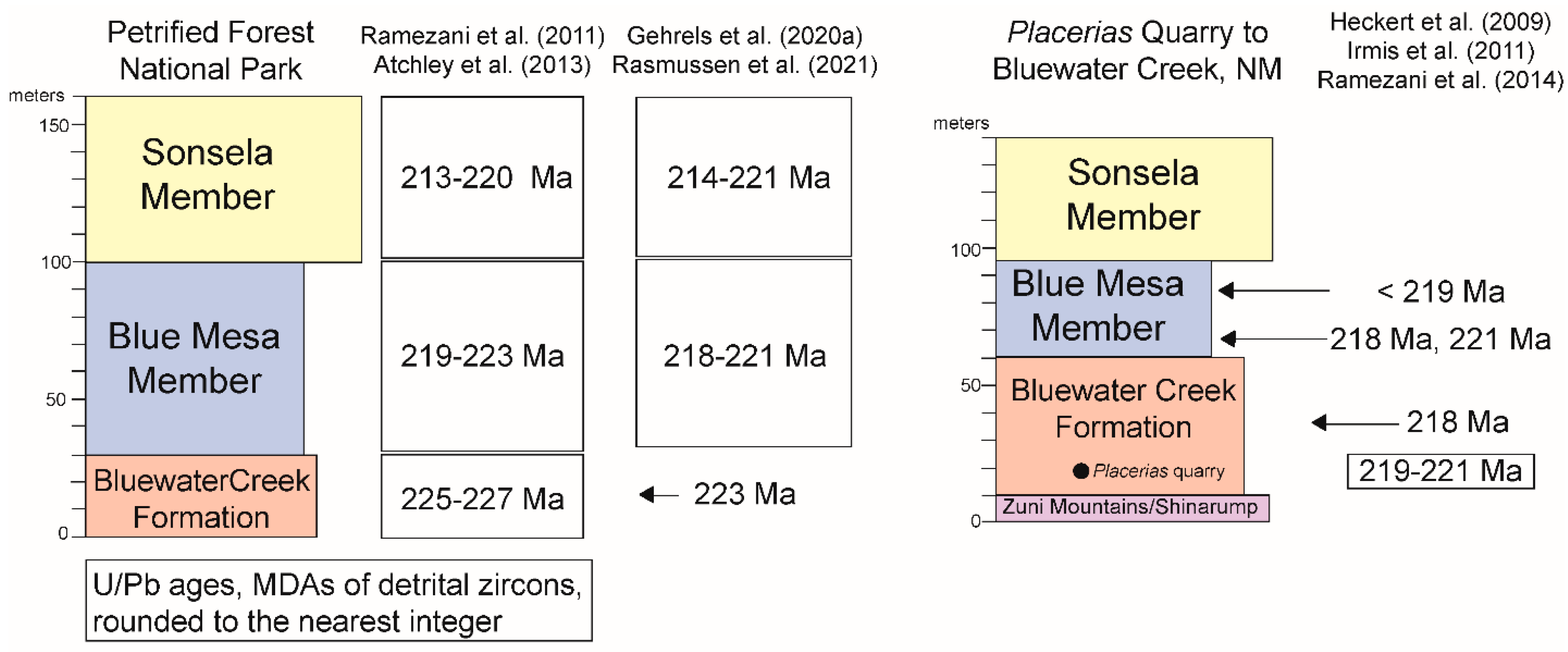
However, when placed into their correct lithostratigraphic position, the U/Pb ages published for the Bluewater Creek Formation and Blue Mesa Member farther east in Arizona and in west-central New Mexico are discordant with these ages (Figure 10). Thus, Irmis et al. [40] reported a U/Pb age of ~218 Ma at the base of the Blue Mesa Member in Sixmile Canyon, New Mexico. This is a Norian age on any timescale. It is also substantially younger than the oldest Blue Mesa Member ages in PEFO (Figure 10). Indeed, based on this age, Marsh et al. [11] reassigned the dated horizon at Sixmile Canyon to the Sonsela Member, even though there is no lithostratigraphic basis for this correlation, especially given that the base of the Sonsela Member is ~42 m above the dated horizon in the same stratigraphic section at Sixmile Canyon [32,40]. Also, note that Heckert et al. [95], in an abstract, reported an ID-TIMS date of ~221 Ma from the same bed Irmis et al. sampled, but this age is also younger than the oldest Blue Mesa Member age reported at PEFO.
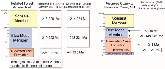
Figure 10.
Lower Chinle Group numerical ages at PEFO compared to the numerical ages of equivalent strata to the east. References cited in the figure are: [9,40,53,90,92,94,95].
The ages reported by Ramezani et al. [9] (Figure 3) from Bluewater Creek Formation strata at the Placerias quarry (their Romero Springs section), not far east at Salado Spring in Arizona and in west-central New Mexico at Bluewater Creek are also anomalously young (Figure 10). They substantially overlap ages from the Sonsela Member at PEFO. Recognizing this, Ramezani et al. [9] (Figure 3) correlated the Bluewater Creek Formation at these localities to the uppermost Blue Mesa Member and the Sonsela Member at PEFO. However, there is no lithologic resemblance between the Bluewater Creek red beds and the Blue Mesa and Sonsela members. And, at Bluewater Creek (and elsewhere), the Blue Mesa Member overlies the Bluewater Creek Formation, and the Sonsela Member overlies the Blue Mesa Member [34,59]. So, by Ramezani et al.’s correlation, the Blue Mesa and Sonsela members at Bluewater Creek must be younger than those same units at PEFO.
In other words, the numerical ages supposedly over-rule the well-established regional lithostratigraphy reviewed above. Ramezani et al. [9] (p. 994) concluded that “the new geochronological results highlight drastic changes in fluvial lithofacies on geographic scales less than 50 km”. They noted that “white, medium- to coarse-siliciclastic deposits of the lower Sonsela Member in PEFO…surprisingly show almost no lithologic resemblance to their age-equivalent, mudstone-dominated beds in the nearby St. Johns-Salado area”. Ramezani et al. [9] (p. 994) concluded that “this further emphasizes the complex, horizontally discontinuous and vertically repetitive depositional architecture of the fluvial deposits in extensional continental settings.” However, the surprise here is that Ramezani et al. [9] were willing, based on a handful of U/Pb ages of detrital zircons, to disregard nearly a century of mapping and lithostratigraphic work by diverse workers (see above) supported by the biostratigraphy. Furthermore, Ramezani et al. [9] presented no lithostratigraphic or biostratigraphic data or analysis to contradict the regional lower Chinle stratigraphy, they simply rejected that lithostratigraphy based on their U/Pb ages.
If the mudrock-dominated strata at the Placerias Quarry and to the east, which yield ages of 218 to <221 Ma, are correlative to the Sonsela Member, where are the pre-Sonsela strata at the Placerias Quarry? That section should be about 100 m thick, but there is not enough subsurface thickness of the Triassic strata at the Placerias Quarry to include that section. Perhaps, Ramezani et al. would argue that these Sonsela-age strata overlie a greatly thinned lower Chinle section or the Moenkopi Formation, though those relationships are not seen to the west or to the east across a broad outcrop belt where the Sonsela is near the middle of the Chinle Group section (Figure 9).
The numerical ages supposedly indicating the age equivalence of the Bluewater Creek Formation and lower Blue Mesa Member in west-central New Mexico to the Sonsela Member at PEFO have been used to argue that Blue Mesa and Sonsela strata are laterally equivalent, so that the two units intertongue [9,11]. However, there is no lithostratigraphic evidence of such intertonguing. Indeed, across east-central Arizona and west-central New Mexico, the Sonsela Member has a sharp contact through the area studied on top of the Blue Mesa Member, often channelized and considered by Heckert and Lucas [1,59] to be a regional unconformity. No worker has ever documented intertonguing of the Blue Mesa and Sonsela members.
At the type section of the Sonsela Member in eastern Arizona, Marsh et al. [11] plotted the age ranges of 69 DZ ages (their “youngest coherent subpopulation of detrital zircons”) and then took the mean value of these ages of 216.57 Ma as the age of the sample, However, the range of ages of this subpopulation of grains is 200 to 235 Ma, and 10 of the grains have age ranges totally older than the mean value and 14 have values younger than the mean. Such a widely dispersed multigrain dataset (its MSWD value of 4.9) is not likely to produce precise age estimates [96,97]. Thus, the age of 216.57 Ma that Marsh et al. [11] advocated for the local Sonsela base is a very imprecisely calculated estimate, and it should not be used for age assignment and correlation.
A misleading aspect of the stratigraphic conclusions of Marsh et al. [11] is their identification of the strata immediately below the type Sonsela section as Bluewater Creek Formation. This contradicts previous workers, who identified the strata beneath the Sonsela Member at its type section as lower Petrified Forest Member (=Blue Mesa Member) [31,60,68]. Lucas et al. [31] (p. 101, Figure 5) described and illustrated that stratigraphic section where the Sonsela is underlain by about 22 m of mostly grayish blue, bentonitic mudrock readily assigned to the Blue Mesa Member. Indeed, Marsh et al.’s [11] (Table 1) stratigraphic section below the type Sonsela is ~30 m of mostly grayish-purple and greenish-gray claystone and siltstone with a friable sandstone interbed, strata characteristic of the Blue Mesa Member.
The anomalously young ages published by Ramezani et al. [9] could be due to undetected lead loss, a common problem with U–Pb ages [97,98,99]. Ramezani and Gehrels in [93] discussed possible lead loss in the PEFO dated samples. But, averaging in multigrain analyses makes it difficult to impossible to recognize U-Pb loss [96]. Thus, “multigrain data in contrast to single-grain data tend to disguise rather than expose complications potentially hidden in zircon populations” [96] (p. 134) and lead to “homogenization of real grain-to-grain dispersion” (p. 142). However, although it is beyond my purpose or resources to determine why the numerical ages published by Ramezani et al. [9] are incorrect, let me offer the following observations:
- The Chinle numerical ages discussed here were determined by four different laboratories (Boston, Vancouver, Tucson and Berkeley). Different laboratories often do not determine the same ages for the same beds. This is well illustrated here by [40], who determined an age of 218.1 ± 0.7 Ma and [95], who determined an age of 220.9 ± 0.6 Ma, on the same tuffaceous bed in the Blue Mesa Member in west-central New Mexico.
- Different datasets have also been employed to determine the Chinle ages. Most of the ages are of zircons that are thought to be of volcanic origin. But, some are of detrital zircons (DZ) reworked into the layer being dated. The DZ ages are maximum depositional ages, not necessarily the age of the bed, whereas the ages of the volcanically derived zircons are more likely to be the age of the bed sampled.
- Many of these Chinle ages are multigrain ages in which the reported age is the average of the different ages of the multiple grains dated, a process that introduces imprecision [96].
- Lead loss is common in zircons and can lead to anomalously young ages [97,98,99]. And, as Ramezani noted in remarking on [93], “no a priori indicator of lead loss exists”, so this undetectable problem can introduce errors into the numerical age estimates.
Regardless of the potential problems with the numerical ages, I conclude that the ages Ramezani et al. [9] published for the Placerias quarry and lower Chinle strata farther east are discordant with other lower Chinle numerical ages and contradict well-established lithostratigraphy and biostratigraphy, so they are not accurate age estimates.
9. Conclusions
Based on the above, the following conclusions are advocated:
- Surface and subsurface stratigraphic data confirm an earlier conclusion that the Placerias Quarry is stratigraphically very low in the Chinle Group, just above the base of the Bluewater Creek Formation.
- Regional lithostratigraphy undertaken by diverse stratigraphers and mappers has established a consistent regional lithostratigraphy of the lower Chinle Group in east-central Arizona and west-central New Mexico of the following units (ascending): Zuni Mountains/Shinarump formations, Bluewater Creek Formation, and Blue Mesa and Sonsela members of the Petrified Forest Formation. No stratigrapher or mapper has identified lateral equivalence or intertonguing of these units.
- Biostratigraphy indicates an age of the Placerias Quarry close to the Otischalkian–Adamanian LVF boundary, which is an age close to (likely slightly younger than) the early-late Carnian (Julian–Tuvalian) boundary, which has an age of about 231 Ma.
- Published U/Pb ages on zircons at the Placerias Quarry of ~219 Ma and of Bluewater Creek Formation and Blue Mesa Member strata to the east of ~218–221 Ma are anomalously young.
- This becomes clear when those ages are compared to the extensive datasets of U/Pb ages on zircons from PEFO, where ages of 221–223 MA are stratigraphically higher than the ages from the Bluewater Creek Formation to the east.
- Lower Chinle Group U/Pb ages need to be placed in the well-established lithostratigraphic framework, not used to modify or overturn that framework. Nearly a century of stratigraphic analysis and geologic mapping by diverse workers established a Chinle Group lithostratigraphy across east-central Arizona and west-central New Mexico. A handful of numerical ages, discordant with others, is not a sound basis for rejecting that lithostratigraphy.
Finally, let me offer a note of caution in the use of numerical ages that is exemplified by the ages associated with the Placerias quarry. Many paleontologists and geologists consider numerical ages to be the “gold standard” for assigning geological ages to rocks and fossils. However, when numerical ages contradict well-established lithostratigraphy and/or biostratigraphy, the numerical ages may simply be incorrect. The Placerias quarry is a good example of this but is not unique. Another good Triassic example that was used to overturn well-established biostratigraphy was recently published based on work in Argentina. There, Ottone et al. [100] published a numerical age of ~236 Ma for a tuff directly associated with Cynognathus assemblage zone tetrapods. This is a Carnian age for a tetrapod assemblage found across much of Triassic Pangea with diverse age constraints that indicate it is no younger than Anisian [101], and thus about 6 million years or more older than the age published by Ottone et al. [100]. As Lucas and Hancox [102] argued, the Ottone et al. [100] age is based on a multigrain dataset with high dispersion and is likely spuriously young due to lead loss. Yet, several paleontologists uncritically adopted that age and assigned the Cynognathus assemblage zone a Carnian age, contradicting more than a century of biostratigraphic analysis, as well as other age constraints.
My recommendation is for greater caution when using and interpreting numerical ages. They are one of several tools available for determining the ages of rocks and fossils. However, this tool has its own limitations and needs to be used judiciously and evaluated critically, especially with regard to well-established lithostratigraphy and biostratigraphy. The most reliable age estimates come from the careful integration of consistent, reinforcing datasets, not from one tool that contradicts all others.
Funding
This research received no external funding.
Data Availability Statement
All data compiled for this study are in the article.
Acknowledgments
Filed research reported here began in the 1990s with the collaboration of Andy Heckert, Adrian Hunt and the late Steve Hayden. I am grateful to John Rogers for assistance in the field in 2019. The reviewers provided helpful comments that improved the content and clarity of the manuscript.
Conflicts of Interest
The author declares no conflict of interest.
References
- Lucas, S.G. The Chinle Group: Revised stratigraphy and biochronology of Upper Triassic nonmarine strata in the Western United States. Mus. North. Ariz. Bull. 1993, 59, 27–50. [Google Scholar]
- Lucas, S.G. Upper Triassic Chinle Group, western United States: A nonmarine standard for Late Triassic time. In Late Paleozoic and Early Mesozoic Circum-Pacific Events and Their Global Correlation; Cambridge University Press: Cambridge, MA, USA, 1997; pp. 209–228. [Google Scholar]
- Lucas, S.G. Late Triassic terrestrial tetrapods: Biostratigraphy, biochronology and biotic events. In The Late Triassic World; Tanner, H.L., Ed.; Springer: Cham, Switzerland, 2018; Volume 46, pp. 351–405. [Google Scholar]
- Camp, C.L.; Welles, S. Triassic dicynodont reptiles. Mem. Univ. Calif. 1956, 13, 255–348. [Google Scholar] [CrossRef]
- Fiorillo, A.R.; Padian, K.; Musikasinthorn, C. Taphonomy and depositional setting of the Placerias quarry (Chinle Formation: Late Triassic, Arizona). Palaios 2000, 15, 373–386. [Google Scholar] [CrossRef]
- Lucas, S.G.; Hunt, A.P. A dicynodont from the Upper Triassic of New Mexico and its biochronological significance. New Mex. Mus. Nat. Hist. Sci. Bull. 1993, 3, 321–325. [Google Scholar]
- Long, R.A.; Murry, P.A. Late Triassic (Camian and Norian) tetrapods from the southwestern United States. New Mex. Mus. Nat. Hist. Sci. Bull. 1995, 4, 1–254. [Google Scholar]
- Lucas, S.G.; Heckert, A.B.; Hunt, A.P. Stratigraphy and biochronological significance of the Late Triassic Placerias Quarry, eastern Arizona (U.S.A.). N. Jb. Geol. Palaont. Abh. 1997, 203, 23–46. [Google Scholar]
- Ramezani, J.; Fastovsky, D.E.; Bowring, S.A. Revised chronostratigraphy of the lower Chinle Formation strata in Arizona and New Mexico (USA): High-precision U-Pb geochronological constraints on the Late Triassic evolution of dinosaurs. Amer. J. Sci. 2014, 314, 981–1008. [Google Scholar] [CrossRef]
- Parker, W.G. Redescription of Calyptosuchus (Stagonolepis) wellesi (Archosauria: Pseudosuchia: Aetosauria) from the Late Triassic of the southwestern United States with a discussion of genera in vertebrate paleontology. Peer J. 2018, 6, e4291. [Google Scholar] [CrossRef]
- Marsh, A.D.; Parker, W.G.; Stockli, D.F.; Martz, J.W. Regional correlation of the Sonsela Member (Upper Triassic Chinle Formation) and detrital U-P{b zircon data from the Sonsela Sandstone bed near the Sonsela Buttes, northwestern Arizona, USA, support the presence of a distributive fluvial system. Geosphere 2019, 15, 1128–1139. [Google Scholar] [CrossRef]
- Camp, C.L.; Colbert, E.H.; McKee, E.D.; Welles, S.P. A guide to the continental Triassic of northern Arizona. Plateau 1947, 20, 1–7. [Google Scholar]
- Jacobs, L.L.; Murry, P.A. The vertebrate community of the Triassic Chinle Formation near St. Johns, Arizona. In Aspects of Vertebrate History: Essays in Honor of Edwin Harris Colbert; Jacobs, L.L., Ed.; Museum of Northern Arizona Press: Flagstaff, AZ, USA, 1980; pp. 55–70. [Google Scholar]
- Akers, J.P. Geology and ground-water in the central part of Apache County, Arizona. U.S. Geol. Surv. Water Sup. Pap. 1964, W1771, 1–107. [Google Scholar]
- Long, R.A.; Padian, K. Vertebrate biostratigraphy of the Late Triassic Chinle Formation, Petrified Foret National Park, Arizona: Preliminary results. In The Beginning of the Age of Dinosaurs; Padian, K., Ed.; Cambridge University Press: Cambridge, MA, USA, 1986; pp. 161–169. [Google Scholar]
- Heckert, A.B.; Nesbitt, S.J.; Stocker, M.R.; Schneider, V.P.; Hoffman, D.K.; Zimmer, B.W. A new short-faced archosauriform from the Upper Triassic Placerias/Downs’ quarry complex, Arizona, USA, expands the morphological diversity of the Triassic archosauriform radiation. Sci. Nat. 2021, 108, 32. [Google Scholar] [CrossRef]
- Tannenbaum, F. The Microvertebrate Fauna of the Placerias and Downs Quarries, Chinle Formation (Upper Triassic) Near St. Johns, Arizona. Master’s Thesis, University of California, Berkeley, CA, USA, 1983; 111p. [Google Scholar]
- Kaye, F.; Padian, K. Microvertebrates from the Placerias quarry: A window on Late Triassic vertebrate diversity in the American Southwest. In In The Shadow if the Dinosaurs: Early Mesozoic Tetrapods; Fraser, N.C., Sues, H.-D., Eds.; Cambridge University Press: Cambridge, MA, USA, 1994; pp. 171–196. [Google Scholar]
- Murry, P.A. New reptiles from the Upper Triassic Chinle Formation of Arizona. J. Paleont. 1987, 61, 773–786. [Google Scholar] [CrossRef]
- Murry, P.A.; Long, R.A. Geology and paleontology of the Chinle Formation, Petrified Forest National Park and Vicinity, Arizona and a discussion of vertebrate fossils of the southwestern Upper Triassic. In Dawn of the Age of Dinosaurs in the American Southwest; Lucas, S.G., Hunt, A.P., Eds.; New Mexico Museum of Natural History: Albuquerque, NM, USA, 1989; pp. 29–64. [Google Scholar]
- Heckert, A.B.; Lucas, S.G. Stratigraphy and paleontology of the lower Chinle Group (Adamanian: Latest Carnian) in the vicinity of St. Johns, Arizona. New Mex. Geol. Soc. Guideb. 2003, 54, 281–288. [Google Scholar]
- Martz, J.W.; Parker, W.G. Revised lithostratigraphy of the Sonsela Member (Chinle Formation, Upper Triassic) in the southern part of Petrified Forest National Park, Arizona. PLoS ONE 2010, 5, e9329. [Google Scholar] [CrossRef]
- Harper, R.W.; Anderson, T.W. Maps Showing Ground-Water Conditions in the Concho, St. Johns, and White Mountains Areas, Apache and Navajo Counties, Arizona; Water-Resources Investigations Report 76-104; U.S. Geological Survey: Reston, VI, USA, 1976. [Google Scholar]
- Mann, L.J.; Nemeck, E.A. Geohydrology and water use in southern Apache County, Arizona. Ariz. Dept. Water Res. Bull. 1983, 1, 1–86. [Google Scholar]
- McKee, E.D. Stratigraphy and history of the Moenkopi Formation of Triassic age. Geol. Soc. Amer. Memoir. 1954, 61, 1–133. [Google Scholar]
- Cooley, M.E. Geology of the Chinle Formation in the Upper Little ·Colorado Drainage area, Arizona and New Mexico. Master’s Thesis, University of Arizona, Tucson, AZ, USA, 1957; pp. 1–317. [Google Scholar]
- Cooley, M.E. Triassic stratigraphy in the state line region of west-central New Mexico and east-central Arizona. New Mex. Geol. Soc. Guideb. 1959, 10, 66–73. [Google Scholar]
- Stewart, J.H.; Poole, F.G.; Wilson, R.F. Stratigraphy and origin of the Moenkopi Formation and related strata in the Colorado Plateau region. U.S. Geol. Surv. Prof. Pap. 1972, 691, 1–195. [Google Scholar]
- Stewart, J.H.; Poole, F.G.; Wilson, R.F. Stratigraphy and origin of the Chinle Formation and related Upper Triassic strata in the Colorado Plateau region. U.S. Geol. Surv. Prof. Pap. 1972, 90, 1–336. [Google Scholar]
- Heckert, A.B. Lithostratigraphy and Biochronology of the Lower Chinle Group, East-Central Arizona and West-Central New Mexico, with a Description of a New Theropod (Dinosauria: Theropoda) From the Bluewater Creek Formation. Master’s Thesis, University of New Mexico, Albuquerque, NM, USA, 1997; pp. 1–278. [Google Scholar]
- Lucas, S.G.; Heckert, A.B.; Estep, J.W.; Anderson, O.J. Stratigraphy of the Upper Triassic Chinle Group, Four Corners region. New Mex. Geol. Soc. Guideb. 1997, 48, 81–107. [Google Scholar]
- Heckert, A.B.; Lucas, S.G. Lower Chinle Group (Upper Triassic, Carnian) stratigraphy in the Zuni Mountains, west-central New Mexico. New Mex. Mus. Nat. Hist. Sci. Bull. 2002, 21, 51–72. [Google Scholar]
- Wilson, E.D.; Moore, R.T.; O’Haire, R.T. Geologic Map of Navajo and Apache Counties, Arizona; Arizona Bureau of Mines, University of Arizona: Tucson, AZ, USA, 1960; scale 1:375,000. [Google Scholar]
- Lucas, S.G.; Hayden, S.N. Triassic stratigraphy of west-central New Mexico. New Mex. Geol. Soc. Guideb. 1989, 40, 191–211. [Google Scholar]
- Green, T.E., Jr. Disturbed Chinle Beds Near St. Johns, Apache County, Arizona. Master’s Thesis, University of Texas at Austin, Austin, TX, USA, 1956; 71p. [Google Scholar]
- Dubiel, R.F.; Ash, S.R.; Hasiotis, S.T. Syndepositional deformation in the Monitor Butte Member of the Chinle Formation at Fort Wingate, NM and St. Johns, AZ. New Mex. Mus. Nat. Hist. Sci. Bull. 1993, 3, G27–G29. [Google Scholar]
- Ash, S.R. (Ed.) Geology, Paleontology, and Paleoecology of a Late Triassic Lake, Western New Mexico; Brigham Young University Geology Studies; Brigham Young University, Department of Geology: Provo, UT, USA, 1978; Volume 25, pp. 1–100. [Google Scholar]
- Heckert, A.B.; Lucas, S.G. Revised Upper Triassic stratigraphy of the Petrified Forest National Park, Arizona, U.S.A. New Mex. Mus. Nat. Hist. Sci. Bull. 2002, 21, 1–36. [Google Scholar]
- Parker, W.G.; Martz, J.W. The Late Triassic (Norian) Adamanian-Revueltian tetrapod faunal transition in the Chinle Formation of Petrified Forest National Park, Arizona. Trans. Royal Soc. Edinb. Earth Environ. Sci. 2011, 101, 231–260. [Google Scholar] [CrossRef]
- Irmis, R.B.; Mundil, R.; Martz, J.W.; Parker, W.G. High-resolution U-Pb ages from the Upper Triassic Chinle Formation (New Mexico, USA) support a diachronous rise of dinosaurs. Earth Planet. Sci. Lett. 2011, 309, 258–267. [Google Scholar] [CrossRef]
- Repenning, C.A.; Irwin, J.H. Bidahochi Formation of Arizona and New Mexico. AAPG Bull. 1954, 38, 1821–1826. [Google Scholar]
- Love, D.W. Bidahochi Formation: An interpretive summary. New Mex. Geol. Soc. Guideb. 1989, 40, 273–280. [Google Scholar]
- Dubiel, R.F. Sedimentology of the Upper Triassic Chinle Formation, Southeastern Utah. Ph.D. Thesis, University of Colorado, Boulder, CO, USA, 1987; pp. 1–132. [Google Scholar]
- Dubiel, R.F. Sedimentology and new fossil occurrences of the Upper Triassic Chinle Formation, southeastern Utah. Four Corners Geol. Soc. Guideb. 1987, 10, 99–107. [Google Scholar]
- Tanner, L.F.; Lucas, S.G. Stratigraphic distribution and significance of a 15 million-year record of fusain in the Upper Triassic Chinle Group, southwestern USA. Palaeoecol. Paaleogeog. Palaeoclimat. 2016, 461, 261–271. [Google Scholar] [CrossRef]
- Hunt, A.P.; Lucas, S.G.; Lockley, M.G. Taxonomy and stratigraphic and facies significance of vertebrate coprolites of the Upper Triassic Chinle Group, western United States. Ichnos 1998, 5, 225–234. [Google Scholar] [CrossRef]
- Hunt, A.P.; Lucas, S.G.; Spielmann, J.A. Triassic vertebrate coprolite ichnofaunas. New Mex. Mus. Nat. Hist. Sci. Bull. 2013, 61, 237–258. [Google Scholar]
- Lucas, S.G.; Tanner, L.H. Record of the Carnian wet episode in strata of the Chinle Group, western USA. J. Geol. Soc. 2018, 175, 1004–1011. [Google Scholar] [CrossRef]
- Bagley, C.T.; Heckert, A.B.; Marshall, S.T.; Ludlum, I. Using electrical resistivity surveys to determine the stratigraphic position of the Upper Triassic Placerias Quarry, east-central Arizona. Geol. Soc. Amer. Abstr. Progr. 2013, 45, 610. [Google Scholar]
- Seidel, K.; Lange, G. Direct current resistivity methods. In Environmental Geology: Handbook of Field Methods and Case Studies; Springer: Berlin/Heidelberg, Germany, 2007; pp. 205–237. [Google Scholar]
- Lawton, T.F. Tectonic setting of Mesozoic sedimentary basins, Rocky Mountain region, United States. In Mesozoic Systems of the Rocky Mountain Region; Caputo, M.V., Peterson, J.A., Franczyk, K.J., Eds.; Rocky Mountain Section (SEPM): Denver, CO, USA, 1994; pp. 1–25. [Google Scholar]
- Riggs, N.R.; Lehman, T.M.; Gehrels, G.E.; Dickinson, W.R. Detrital zircon link between headwaters and terminus of the Upper Triassic Chinle-Dockum paleoriver system. Science 1996, 273, 97–100. [Google Scholar] [CrossRef]
- Atchley, S.C.; Nordt, L.C.; Dworkin, S.I.; Ramezani, J.; Parker, W.G.; Ash, S.R.; Bowring, S.A. A linkage among Pangean tectonism, cyclic alluviation, climate change, and biologic turnover in the Late Triassic: The record from the Chinle Formation, southwestern United States. J. Sed. Res. 2013, 83, 147–161. [Google Scholar] [CrossRef]
- Olsen, P.E.; Geissman, J.W.; Kent, D.V.; Gehrels, G.E.; Mundil, R.; Irmis, R.B.; Lepre, C.; Rasmussen, C.; Giesler, D.; Parker, W.G.; et al. Colorado Plateau Coring Project, Phase I (CPCP-I): A continuously cored, globally exportable chronology of Triassic continental environmental change from western North America. Sci. Drill. 2018, 24, 15–40. [Google Scholar] [CrossRef]
- Haque, Z.; Geissman, J.W.; Irmis, R.B.; Olsen, P.E.; Lepre, C.; Buhedma, H.; Mundil, R.; Parker, W.G.; Rasmussen, C.; Gehrels, G.E. Magnetostratigraphy of the Triassic Moenkopi Formation from the continuous cores recovered in Colorado Plateau Coring Project Phase 1 (CPCP-1), Petrified Forest National park, Arizona, USA: Correlation of the Early to Middle Triassic strata and biota in Colorado Plateau and its environs. JGR Solid Earth 2021, 126, e2021JB021899. [Google Scholar] [CrossRef]
- Harrell, M.A.; Eckel, E.B. Ground-water resources of the Holbrook region, Arizona. U.S. Geol. Surv. Prof. Pap. 1939, 836-B, 19–105. [Google Scholar]
- Heckert, A.B.; Lucas, S.G. The oldest Triassic strata exposed in the Petrified Forest National Park, Arizona. U.S. Dept. Inter. Natl. Park Serv. Tech. Rep. 1998, NPS/NRGRD/GRDTR-98/01, 129–134. [Google Scholar]
- Deacon, M.W. Depositional Analysis of the Sonsela Sandstone Bed, Chinle Formation, Northeast Arizona and Northwest New Mexico. Master’s Thesis, Northern Arizona University, Flagstaff, AZ, USA, 1990; pp. 1–127. [Google Scholar]
- Heckert, A.B.; Lucas, S.G. Stratigraphic description of the Tr-4 unconformity in west-central New Mexico and eastern Arizona. New Mex. Geol. 1996, 18, 61–70. [Google Scholar] [CrossRef]
- Repenning, C.A.; Cooley, M.E.; Akers, J.P. Stratigraphy of the Chinle and Moenkopi Formations, Navajo and Hopi Indian Reservations Arizona, New Mexico, and Utah. U.S. Geol. Surv. Prof. Pap. 1969, 521-B, 1–34. [Google Scholar]
- Darton, N.H. “Red beds” and associated formations in New Mexico. U.S. Geol. Surv. Bull. 1928, 794, 1–356. [Google Scholar]
- Camp, C.L. A study of the phytosaurs, with description of new material from western North America. Mem. Univ. Calif. 1930, 10, 1–161. [Google Scholar]
- Foster, R.W. Stratigraphy of west-central New Mexico. Four Corners Geol. Soc. Guideb. 1957, 2, 62–72. [Google Scholar]
- Smith, C.T. Geology of the Thoreau Quadrangle, McKinley and Valencia counties, New Mexico. New Mex. Bur. Mines Min. Res. Bull. 1954, 31, 1–22. [Google Scholar]
- Smith, C.T. Geology of the Zuni Mountains, Valencia and McKinley counties, New Mexico. Four Corners Geol. Soc. Guideb. 1957, 2, 53–61. [Google Scholar]
- Smith, C.T. Geology of the Foster Canyon Quadrangle, Valencia and McKinley counties, New Mexico. New Mex. Bur. Mines Min. Res. Geol. Map 1958, 9. scale 1:48,000. [Google Scholar]
- Cooley, M.E. The Mesa Redondo Member of the Chinle Formation, Apache and Navajo Counties, Arizona. Plateau 1958, 31, 7–15. [Google Scholar]
- Akers, J.P.; Cooley, M.E.; Repenning, C.A. Moenkopi and Chinle formations of Black Mesa (Arizona) and adjacent areas. New Mex. Geol. Soc. Guideb. 1958, 9, 88–94. [Google Scholar]
- Thaden, R.E.; Ostling, E.J. Geologic map of the Bluewater Quadrangle Valencia and McKinley counties New Mexico. U.S. Geol. Surv. Map 1967, GQ-679. scale 1:24,000. [Google Scholar]
- Green, M.W.; Pierson, C.T. Geologic map of the Thoreau Quadrangle McKinley County, New Mexico. U.S. Geol. Surv. Map 1971, GQ-954. scale 1:24,000. [Google Scholar]
- O’Sullivan, R.B. The Upper Triassic Chinle Formation in north-central New Mexico. New Mex. Geol. Soc. Guideb. 1974, 25, 171–174. [Google Scholar]
- O’Sullivan, R.B. Triassic rocks in the San Juan Basin of New Mexico and adjacent area. New Mex. Geol. Soc. Guideb. 1977, 28, 139–146. [Google Scholar]
- Billingsley, G.H. General stratigraphy of the Petrified Forest National Park, Arizona. Mus. North. Ariz. Bull. 1985, 54, 3–8. [Google Scholar]
- Billingsley, G.H. Geological Map of the Petrified Forest National Park, Arizona; Petrified Forest Museum Association: Petrified Forest National Park, AZ, USA, 1985; scale 1:48,000. [Google Scholar]
- Robertson, J.F. Geologic map of the Thoreau Quadrangle, McKinley County, New Mexico. U.S. Geol. Surv. Map 1990, GQ-1675. scale 1:24,000. [Google Scholar]
- Hackman, R.J.; Olson, A.B. Geology, structure, and uranium deposits of the Gallup 1o x 2o Quadrangle, New Mexico and Arizona. U.S. Geol. Surv. Map 1997, I-981. scale 1:250,000. [Google Scholar]
- Lucas, S.G.; Heckert, A.B.; Anderson, O.J. Triassic stratigraphy and paleontology on the Fort Wingate quadrangle, west-central New Mexico. New Mex. Geol. 1997, 19, 33–42. [Google Scholar] [CrossRef]
- Polcyn, M.J.; Winkler, D.S.; Jacobs, L.L.; Newman, K. Fossil occurrences and structural disturbance in the Triassic Chinle Formation at North Stinking Springs Mountain New St. Johns, Arizona. New Mex. Mus. Nat. Hist Sci. Bull. 2002, 21, 43–49. [Google Scholar]
- Anderson, O.J.; Maxwell, C.H.; Lucas, S.G. Geology of Fort Wingate quadrangle, McKinley County, New Mexico. New Mex. Bur. Geol. Min. Res. Open-file Rep. 2003, 473, 1–14, 1:24,000 geologic map. [Google Scholar]
- Woody, D.T. Revised stratigraphy of the lower Chinle Formation (Upper Triassic) of Petrified Forest National Park. Mus. N. Ariz. Bull. 2006, 62, 17–45. [Google Scholar]
- Martz, J.W.; Parker, W.G.; Skinner, L.; Raucci, J.J.; Umhoefer, P.; Blakey, R.C. Geological Map of Petrified Forest National Park, Arizona; Arizona Geological Survey Contributed Map; 1 Map Sheet, scale: 1:50,000; Arizona Geological Survey: Tucson, AZ, USA, 2012; Volume CM-12-A, pp. 1–18. [Google Scholar]
- Lucas, S.G. Triassic stratigraphy of the southeastern Colorado Plateau, west-central New Mexico. New Mex. Geol. Soc. Guideb. 2021, 71, 229–239. [Google Scholar]
- Lucas, S.G.; Tanner, L.H.; Kozur, H.W.; Weems, R.E.; Heckert, A.B. The Late Triassic timescale: Age and correlation of the Carnian-Norian boundary. Earth-Sci. Rev. 2012, 114, 1–18. [Google Scholar] [CrossRef]
- Kozur, H.W.; Weems, R.E. The biostratigraphic importance of conchostracans in the continental Triassic of the northern hemisphere. Geol. Soc. Lond. Spec. Pub. 2010, 334, 315–417. [Google Scholar] [CrossRef]
- Ash, S.R. Upper Triassic floral zones of North America. In Biostratigraphy of Fossil Plants; Dilcher, D.L., Taylor, T.M., Eds.; Dowden, Hutchinson and Ross, Inc.: Stroudsburg, PA, USA, 1980; pp. 153–270. [Google Scholar]
- Litwin, R.L.; Traverse, A.; Ash, S.R. Preliminary palynological zonation of the Chinle Formation, southwestern U.S.A., and its correlation to the Newark Supergroup (eastern U.S.A.). Rev. Palaeobot. Palynol. 1991, 68, 259–287. [Google Scholar] [CrossRef]
- Lucas, S.G. Plant megafossil biostratigraphy and biochronology, Upper Triassic Chinle Group, western USA. New Mex. Mus. Nat. Hist. Sci. Bull. 2013, 61, 354–363. [Google Scholar]
- Furin, S.; Preto, N.; Rigo, M.; Roghi, G.; Gianolla, P.; Crowley, J.L.; Bowring, S.A. High-precision U-Pb zircon age from the Triassic of Italy: Implications for the Triassic time scale and the Carnian origin of calcareous nannoplankton and dinosaurs. Geology 2006, 34, 1009–1012. [Google Scholar] [CrossRef]
- Ogg, J.G.; Chen, Z.Q.; Orchard, M.J.; Jiang, H.S. The Triassic Period. In Geologic Time Scale 2020; Gradstein, F.M., Ogg, J.G., Schmitz, M.D., Ogg, G.M., Eds.; The Geologic Time Scale 2012; Elsevier: Amsterdam, The Netherlands, 2020; Volume 2, pp. 903–953. [Google Scholar]
- Ramezani, J.; Hoke, G.D.; Fastovsky, D.E.; Bowring, S.A.; Therrien, F.; Dworkin, S.I.; Atchley, S.C.; Nordt, L.C. High-precision U-Pb zircon geochronology of the Late Triassic Chinle Formation, Petrified Forest National Park (Arizona, USA): Temporal constraints on the early evolution of dinosaurs. GSA Bull. 2011, 123, 2142–2159. [Google Scholar] [CrossRef]
- Dickinson, W.R.; Gehrels, G.E. Use of U-Pb ages of detrital zircons to infer maximum depositional ages of strata: A test against a Colorado Plateau Mesozoic database. Earth Planet. Sci. Lett. 2009, 288, 115–125. [Google Scholar] [CrossRef]
- Gehrels, G.; Giesler, D.; Olsen, P.; Kent, D.; Marsh, A.; Parker, W.; Rasmussen, C.; Mundil, R.; Irmis, R.; Geissman, J.; et al. LA-ICPMS U-Pb geochronology of detrital zircon grains from the Coconino, Moenkopi, and Chinle formations in the Petrified Forest National Park (Arizona). Geochronology 2020, 2, 257–282. [Google Scholar] [CrossRef]
- Gehrels, G.; Giesler, D.; Olsen, P.; Kent, D.; Marsh, A.; Parker, W.; Rasmussen, C.; Mundil, R.; Irmis, R.; Geissman, J.; et al. Interactive comment on “LA-ICPMS U-Pb geochronology of detrital zircon grains from the Coconino, Moenkopi, and Chinle formations in the Petrified Forest National Park (Arizona)” by George Gehrels et al. Geochron. Discuss 2020, 2020, 1–7. [Google Scholar]
- Rasmussen, C.; Mundil, R.; Irmis, R.B.; Geisler, D.; Gehrels, G.E.; Olsen, P.E.; Kent, D.V.; Lepre, C.; Kinney, S.T.; Geissman, J.W.; et al. U-Pb zircon geochronology and depositional age models for the Upper Triassic Chinle Formation (Petrified Forest National Park, Arizona, USA): Implications for Late Triassic paleoecological and paleoenvironmental change. GSA Bull. 2021, 133, 539–558. [Google Scholar] [CrossRef]
- Heckert, A.B.; Lucas, S.G.; Dickinson, W.R.; Mortensen, J.K. New ID-TIMS U-Pb ages for Chinle Group strata (Upper Triassic) in New Mexico and Arizona, correlation to the Newark Supergroup, and implications for the “long Norian”. Geol. Soc. Amer. Abstr. Progr. 2009, 41, 123. [Google Scholar]
- Mundil, R.; Metcalfe, I.; Ludwig, K.; Renne, P.R.; Oberli, F.; Nicoll, R.S. Timing of the Permian-Triassic biotic crisis: Implications from new zircon U/Pb age data and their limitations. Earth Planet. Sci. Lett. 2001, 187, 131–145. [Google Scholar] [CrossRef]
- Schoene, B. U–Th–Pb geochronology. Treatise Geochem. 2014, 4, 341–378. [Google Scholar]
- Metzger, K.; Krogstad, E.J. Interpretation of discordant U-Pb zircon ages: An evaluation. J. Metamorph. Geol. 1997, 15, 127–140. [Google Scholar] [CrossRef]
- Bowring, S.A.; Schoene, B.; Crowley, J.L.; Ramezani, J.; Condon, D.J. High-precision U–Pb zircon geochronology and the stratigraphic record: Progress and promise. Geochronol. Emerg. Oppor. 2006, 11, 23–43. [Google Scholar] [CrossRef]
- Ottone, E.G.; Monti, M.; Marsicano, C.A.; de la Fuente, M.S.; Naipauer, M.; Armstrong, R.; Mancuso, A.C. A new Late Triassic age for the Puesto Viejo Group (San Rafael depocenter, Argentina): SHRIMP U–Pb zircon dating and biostratigraphic correlations across southern Gondwana. J. S. Am. Earth Sci. 2014, 56, 186–199. [Google Scholar] [CrossRef]
- Lucas, S.G.; Hancox, P.J. Age and correlation of the bone-bearing Puesto Viejo Group, Triassic of Argentina. Paleont. J. 2022, 56, 1512–1517. [Google Scholar] [CrossRef]
- Lucas, S.G.; Hancox, P.J. Definition, correlation and age of the Cynognathus assemblage zone, Lower–Middle Triassic of Pangea. Paleont. J. 2022, 56, 1518–1537. [Google Scholar] [CrossRef]

Disclaimer/Publisher’s Note: The statements, opinions and data contained in all publications are solely those of the individual author(s) and contributor(s) and not of MDPI and/or the editor(s). MDPI and/or the editor(s) disclaim responsibility for any injury to people or property resulting from any ideas, methods, instructions or products referred to in the content. |
© 2025 by the author. Licensee MDPI, Basel, Switzerland. This article is an open access article distributed under the terms and conditions of the Creative Commons Attribution (CC BY) license (https://creativecommons.org/licenses/by/4.0/).